Review

A Systematic Review of Existing Early Warning Systems’ Challenges and Opportunities in Cloud Computing Early Warning Systems

by
Israel Edem Agbehadji
1,*,
Tafadzwanashe Mabhaudhi
1,2,
Joel Botai
3 and
Muthoni Masinde
4
1
Centre for Transformative Agricultural and Food Systems, School of Agricultural, Earth and Environmental Sciences, University of KwaZulu-Natal, Private Bag X01, Pietermaritzburg 3209, South Africa
2
International Water Management Institute, Southern Africa Office, 333 Grosvenor Street, Hatfield, Pretoria 0083, South Africa
3
South African Weather Service (SAWS), Private Bag X097, Centurion, Pretoria 0157, South Africa
4
Department of IT, Central University of Technology, Free State Private Bag X20539, Bloemfontein 9301, South Africa
*
Author to whom correspondence should be addressed.
Climate 2023, 11(9), 188; https://doi.org/10.3390/cli11090188
Submission received: 9 August 2023 / Revised: 1 September 2023 / Accepted: 2 September 2023 / Published: 8 September 2023

Abstract

:
This paper assessed existing EWS challenges and opportunities in cloud computing through the PSALSAR framework for systematic literature review and meta-analysis. The research used extant literature from Scopus and Web of Science, where a total of 2516 pieces of literature were extracted between 2004 and 2022, and through inclusion and exclusion criteria, the total was reduced to 98 for this systematic review. This review highlights the challenges and opportunities in transferring in-house early warning systems (that is, non-cloud) to the cloud computing infrastructure. The different techniques or approaches used in different kinds of EWSs to facilitate climate-related data processing and analytics were also highlighted. The findings indicate that very few EWSs (for example, flood, drought, etc.) utilize the cloud computing infrastructure. Many EWSs are not leveraging the capability of cloud computing but instead using online application systems that are not cloud-based. Secondly, a few EWSs have harnessed the computational techniques and tools available on a single platform for data processing. Thirdly, EWSs combine more than one fundamental tenet of the EWS framework to provide a holistic warning system. The findings suggest that reaching a global usage of climate-related EWS may be challenged if EWSs are not redesigned to fit the cloud computing service infrastructure.

1. Introduction

An early warning system (EWS) is an integrated system that facilitates preparedness and response mechanisms through the dissemination of early warning to reduce the impact of a natural disaster. An early warning system is an indispensable tool that helps save lives and reduce the impact of disasters on any infrastructure, such as roads, buildings, farmlands, etc. It has been estimated that USD 800 million is spent annually to develop and operationalize EWSs in developing countries that lack the requisite resources to mitigate the impact of any natural disaster [1]. From a global context, it is estimated that the ratio of persons with access to early warning services is one in three people, whereas the proportion is twice as high in Africa. Currently, it is estimated that 3.3 to 3.6 billion people live in situations that are highly vulnerable to climate-related events [2]. Thus, Africa might have more vulnerable people than any part of the world. Therefore, to bridge this gap, new adaptation strategies that leverage the capability of digital technologies are required to empower the majority of vulnerable people and to ensure effective risk knowledge gathering, monitoring, prediction, dissemination of warning information, and response mechanisms [3].
An early warning system helps with people’s coping mechanisms during a natural disaster. However, its limited use can negatively impact coping mechanisms. Aside from this, EWSs are unable to effectively share computational resources because of platform dependency constraints and the need to protect legacy early warning systems. Consequently, this limits system integration and data acquisition that support climate events simulation models. Furthermore, even if large data are fed into climate models, as the data sets grow exponentially, their computational capability deteriorates, leading to inaccurate climate event prediction. Despite this, no single climate model addresses all the uncertainties of an early warning system [4]. Therefore, the choice of computational model has an impact on an EWS’s computational performance, which can cause a delay in warning dissemination [5].
Climate change has the propensity to threaten human lives, and this calls for international organizations and researchers to intervene in finding alternative approaches that harness computational models for improved performance, thereby ensuring everyone on the planet is protected by early warning systems. There is a need for dynamic climate data-capturing techniques in order to create a uniform integrated service structure that supports early warning service management [2]. An effective warning system coordinates different stakeholders to create the required EWS value chain that could assure the provision of a standard early warning alert procedure among stakeholders. Dutta [6] suggests that information dissemination among stakeholders is still a gap in the design of EWS, and if this is addressed, it can provide efficiently reliable, timely, and accurate information to all stakeholders within the value chain of climate risk reduction and mitigation.
Despite a need to substantially intensify access and availability of EWS globally by 2030, there is currently no research that categorizes climate-related EWSs as either utilizing digital technology infrastructure, such as the cloud service infrastructure, or not. The cloud computing framework offers value in terms of access and interactivity with volumes of data [7]. It is touted to provide standard web services and open data that can support distributed services and interoperable systems. Again, it facilitates the application of open-source applications and greatly contributes to the distribution of early warning system applications. Furthermore, the cloud infrastructure supports new emerging technologies like the Internet of Things (IoT) to facilitate risk knowledge gathering, prediction, detection, monitoring, and collection of climate-related data [8]. However, the services’ interoperability and open or big data are uncommon on local systems or server-client applications that are built in-house for climate-related EWS [9]. Big data is characterized by the value created from voluminous data which is processed quickly irrespective of the data variability. To this end, this study conducts a systematic review of existing early warning systems to highlight the challenges and opportunities for cloud computing-based early warning systems. Thus, the following research objectives are raised:
Research objective 1: To examine existing literature on climate-related EWS and identify the underlying approaches and challenges. Thus, the following research questions were raised:
RQ1: Which existing climate-related EWSs are not based on cloud service infrastructure?
RQ2: What modelling approaches are utilised in assessing the effectiveness of the existing climate-related EWS?
RQ3: How are the challenges with existing climate-related EWSs addressed?
RQ4: Which type of existing climate-related EWS had the highest and the least number of studies?
Research objective 2: To examine extant literature on the categories of climate-related EWS in cloud computing environments and identify the approaches, opportunities, and limitations. Thus, the following research questions were raised:
RQ5: What is the current cloud-based climate-related EWS?
RQ6: Which modelling approaches are common to measure cloud-based climate-related EWS effectiveness?
RQ7: What are the opportunities for cloud-based climate-related EWSs?
RQ8: What are the limitations of cloud-based climate-related EWSs?
RQ9: Which cloud-based climate-related EWS types had the highest and the least number of studies?
RQ10: To what extent do extant literature on climate-related EWSs (both cloud EWS and non-cloud EWS) cover more than one fundamental tenet of the EWS framework?
These questions are important in making decisions about approaches used in cloud and non-cloud-based EWSs for the needed policy intervention, which is achieved from the perspective of academic researchers who are subject area experts within a wider body of knowledge. The remaining sections of this paper are presented as follows: related literature on EWSs (Section 2); method and material (Section 3); results (Section 4); results discussion (Section 5); limitations, practical and policy implication (Section 6); and conclusion (Section 7).

2. Related Literature on EWS

2.1. Fundamental Tenet of Early Warning Systems

The Early Warning System (EWS) framework comprises complex processes interlinked to provide the needed structure that supports timely information dissemination on natural disasters. Its fundamental tenet of the framework comprises a warning model including a monitoring model, a communication strategy, and an emergency plan to help in managing natural disasters [10,11]. This shows an interdisciplinary knowledge integration between scientists, researchers, and stakeholders towards creating an effective climate-related EWS model for disaster management [12]. Key stakeholders who interface with the processes include government agencies, communities, and individuals. The challenge with the fundamental tenet is the extent of coverage of a climate event and the adequacy of tools for risk gathering, which includes observation and data collection and the likely impact on people, infrastructure, etc. Climate risk is multidimensional and comprises exposure of people or assets to the hazard, vulnerability, and coping strategies of persons exposed to the hazard [13]. An example of a risk framework is INFORM [14], which is an open-source risk framework. The monitoring and prediction utilise technologies or tools to assist in processing observed climate conditions in real time to determine the possible outcome of climate-related events. Dissemination and response mechanisms help in communicating prediction outcomes to communities that are impacted by climate events. Though there are challenges associated with each process, a timely response mechanism from an established relief agency is the most challenging [15]. Unfortunately, even when warning information is issued in good time, it either may not reach many people at risk or people in the affected community may fail to adhere to warning messages [16]. Though [17] outlined factors hindering the effective operation of disaster management practices, it is imperative to establish effective service platforms that leverage technologies, such as cloud computing, in bridging the gap in disaster-related management practices.
The Sendai framework is also a disaster risk framework that provides measures to address multidimensional risk factors and prevent emerging risks. Sendai’s framework outlines seven global pillars for sustainable access and availability of early warning systems, which is equally in line with the 2030 vision of increasing the availability and access of early warning systems. In spite of this, multinational organizations, such as the World Meteorological Organization (WMO) and the Global Water Partnership, have programmes and policies to support the implementation of the Sendai Framework. The challenge with the Sendai framework is the lack of consistent and systematic data collection and reporting regimes from established government agencies [18]. Resolving this challenge enhances communication and ensures that early warnings reach the final consumer or individual. Therefore, the social, technological, and organizational contexts are imperative for improving the value-addition process of EWSs. Within the social context, an EWS serves as the information delivery mechanism for people who are vulnerable. The technological context focuses on tools that help in the automation of services to build the required EWS value chain. The organizational context focuses on agencies responsible for receiving appropriate funding that helps in implementing an intervention mechanism for society. These contexts are significant in creating a value chain to ensure the timely delivery of early warnings. Scientific and managerial considerations are drivers for effective communication of early warning [19]. In view of these, scientific knowledge helps to give credence and quantitative measures on drivers for effective warning systems and also helps identify practical, managerial, or technical considerations to inform the right stakeholders of the appropriate intervention.

2.2. Existing Early Warning Systems

Existing EWSs store and process climate risk data in-house or on local servers, where data processing becomes a challenge when climate data is voluminous. Existing EWSs deployed on web-based platforms that are managed on a single server need continuous updates of their dataset; however, due to the volume of data required, its operation becomes a challenge. Therefore, it is imperative to ensure an effective integrated service automation. Thus, a web-based platform is a basic step toward operating EWSs [20]. For the purpose of this research, existing EWSs are described as warning systems developed without using a cloud computing framework. Web-based systems that offer static and limited interaction with data might have structured processes but lack dynamism in gathering risk information, monitoring, and predicting recurring or occurring natural disasters, including droughts, floods, earthquakes, etc., [21].
A drought EWS is complex because of the biophysical drivers involved in creating different drought indicators. Additionally, human experiences of drought and its impacts contribute to the complexity of creating a drought EWS, thus leading to a challenge in designing drought monitoring early warning (MEW) systems, which are key in drought preparedness [22]. Flash drought has rapid intensification without sufficient early warning, which poses a challenge in current flash drought early warning systems, and thus, typifying flash drought events to find the risk of exposure is still a challenge [23]. The challenges with on-site earthquake EWSs include predicting the location, magnitude, and structural drift to enhance seismic preparedness and safety measures [24,25,26]. For example, the extended “integrated particle filter” (IPFx) is an automated earthquake source identification system for the “Japanese earthquake early warning” (EEW) system, which sends early warnings during active seismicity [27]. Floods are the most frequent type of natural disaster, and the challenges with a flood EWS include the accurate sensing of flood to prevent damage to property and life [28], determination of the warning module’s threshold, hydraulic model development, and calibration [29]. An example of a flood-based EWS that leverages the web-application technology, server, and IoT has been proposed by [30]. A landslide EWS requires monitoring and prediction because of its internal mechanism, which requires precise mechanistic models [31]. While many early warning systems can be identified, hydro meteorological hazards remain the most prevalent that impact society both simultaneously and sequentially [32].
The underlying automated technique of an EWS is a computational algorithm that automates the data processing and modelling of the right set of metrics for any natural disaster [33]. Examples of such computational algorithms include artificial neural networks (ANNs) for detecting control risk parameters [33], recursive neural networks for drought forecasting [34], a combination of neural networks and support vector machines for drought prediction [35], the FinDer algorithm [36], etc. DroughtCast includes a machine-learning framework for forecasting drought a week or month before its occurrence [37]. Similarly, “ANYWHERE DEWS” (AD-EWS) is a hydrometeorological drought forecasting system that provides a wide range of indices on water cycle components, such as groundwater, soil moisture, etc. [38]. In spite of these algorithms, the success of early warning systems depends on end-users because they act on the warning message to reduce the impact of climate events on their lives and infrastructure [38].
The challenge with existing climate-related EWS is the inability to process a large set of climate-related data to fit different sets of climate conditions. For instance, data on the location of vulnerable people and infrastructure can be very large, such that it becomes difficult to create and process the required set of risk map metrics. Though the underlying algorithm of an EWS can lead to different processing outcomes at the same time [39], as technology advances, more effective computational platforms with several algorithms can be utilised to overcome the computational challenges of existing climate-related EWSs.

2.3. Cloud Computing-Based EWS Opportunities

Cloud computing is an information technology framework that provides a service infrastructure for different users to access large-scale and shared computing infrastructure capability over the internet. Cloud-based computing platforms also use web-based infrastructure to offer computing capabilities and robust data processing computational models. They can offer substantial access to several warning systems using their shared pool capabilities, thereby ensuring sustainable availability. Sharing cloud resources is more advantageous than expanding existing web-based platforms [40]. The advantage of cloud computing technology is access to real-time voluminous data processing and its ability to obtain a huge volume of data from different integrated systems. Again, its mechanism facilitates easy deployment, offers on-demand scalability, and ensures wide accessibility of resources to help create dynamic systems [41]. The success of EWSs can be measured by their impact on saving lives, land, and infrastructures and supporting the long-term sustainability of the EWS. Generally, people adopt different coping mechanisms for different climate-related events based on the warning information they receive. The benefit of a cloud computing platform is that it provides well-tested cloud platforms that can support pre-emptive modelling of climate events in real time. Again, cloud interoperability ensure one cloud service is connected with another to share data, thereby increasing access to early warning information.
Cloud computing, as an information technology architecture, hosts remote servers on the internet and provides virtual data storage and processing of data. Its architecture can be categorised into private, public, hybrid, and multi-cloud. The hybrid cloud combines a company’s on-premises private cloud and third-party, public cloud services into a single application. The multi-cloud architecture uses several cloud vendors to distribute applications on several cloud environments. Aside from the cloud computing architecture, there are three main services that are provided: infrastructure as a service (IaaS), platform as a service (PaaS), and software as a service (SaaS). IaaS provides computation, networking, and storage resources on demand, whereas PaaS provides hardware, software, and platforms to support the development and maintenance of software or applications on an organization’s computing infrastructure. SaaS is similar to IaaS and PaaS in that it offers software online that can be subscribed to by its users. Multi-cloud provides a mix of IaaS, PaaS, or SaaS resources. This architecture and its services ensure the availability of applications and data governance. Data governance defines how data is collected, stored, and used from top-down and bottom-up [42], thus creating the required framework to support information dissemination from the national (government), local (community), and user (individual) levels. Big data has become an important intangible asset to many organizations, and when measurable performance indicators are set, it creates the needed value chain for data governance [43]. In this regard, cloud computing architecture guarantees reliable data for accurate prediction of climate events in EWS [44].
Both cloud computing-based EWSs and non-cloud EWSs (i.e., existing EWSs) use the internet as a backbone. However, the difference lies in the underlying architecture, which can either be IaaS, SaaS, and PaaS or server-client (e.g., a local server). Cloud storage provides a set of servers with larger capacities to manage voluminous demands for data storage and access. However, the barriers to cloud computing adoption include organisational culture, security, and trust in adopting new technology, such as the “cloud” [45]. Amron, Ibrahim [46] ranked compatibility, top management support, and benefit as the first three factors that influence acceptance of cloud technology.
Since cloud computing allows the sharing of resources, it is easy to share location data [21], which can be used to identify vulnerable communities and people in any disaster situation. Cloud-based search engines that leverage location data in real-time facilitate risk knowledge gathering, monitoring, and warning dissemination to create a customised visualization of a map of a geographical location [21]. Planning the infrastructure of the EWS is crucial to ensure a dynamic location data gathering [47]. Some examples of cloud computing-based EWS include Geological Hazard EWS [48]. Cloud computing-based search engines employ parallel cloud computing capabilities to overcome location data computational challenges. Thus, this makes it easy to incorporate climate-driven data in spatial scales. Among the parallel cloud computing search engines or applications is Google Earth Engine, which provides real-time remote sensing [21]. Search engines are built using algorithms that are executed by the cloud servers for geological disaster prediction and modelling in Geographic Information Systems [48]. “Retrieving Environmental Analytics for Climate and Health” (REACH) is another cloud-based application that uses Google Earth Engine (GEE) to process data on land surface temperature, spectral indices, and precipitation [49]. Algorithms (e.g., machine-learning algorithms), when put on a single platform, such as hybrid cloud, provide the needed flexibility of performing different computing tasks at a greatly reduced cost. In contrast, non-cloud-based systems are unable to provide such algorithm flexibility, which impacts negatively on their performance. Artificial intelligence and cloud-based collaborative platforms provide a logical and structured approach for algorithms to collect and analyse data in order to devise the required strategy for any natural disaster management [50].

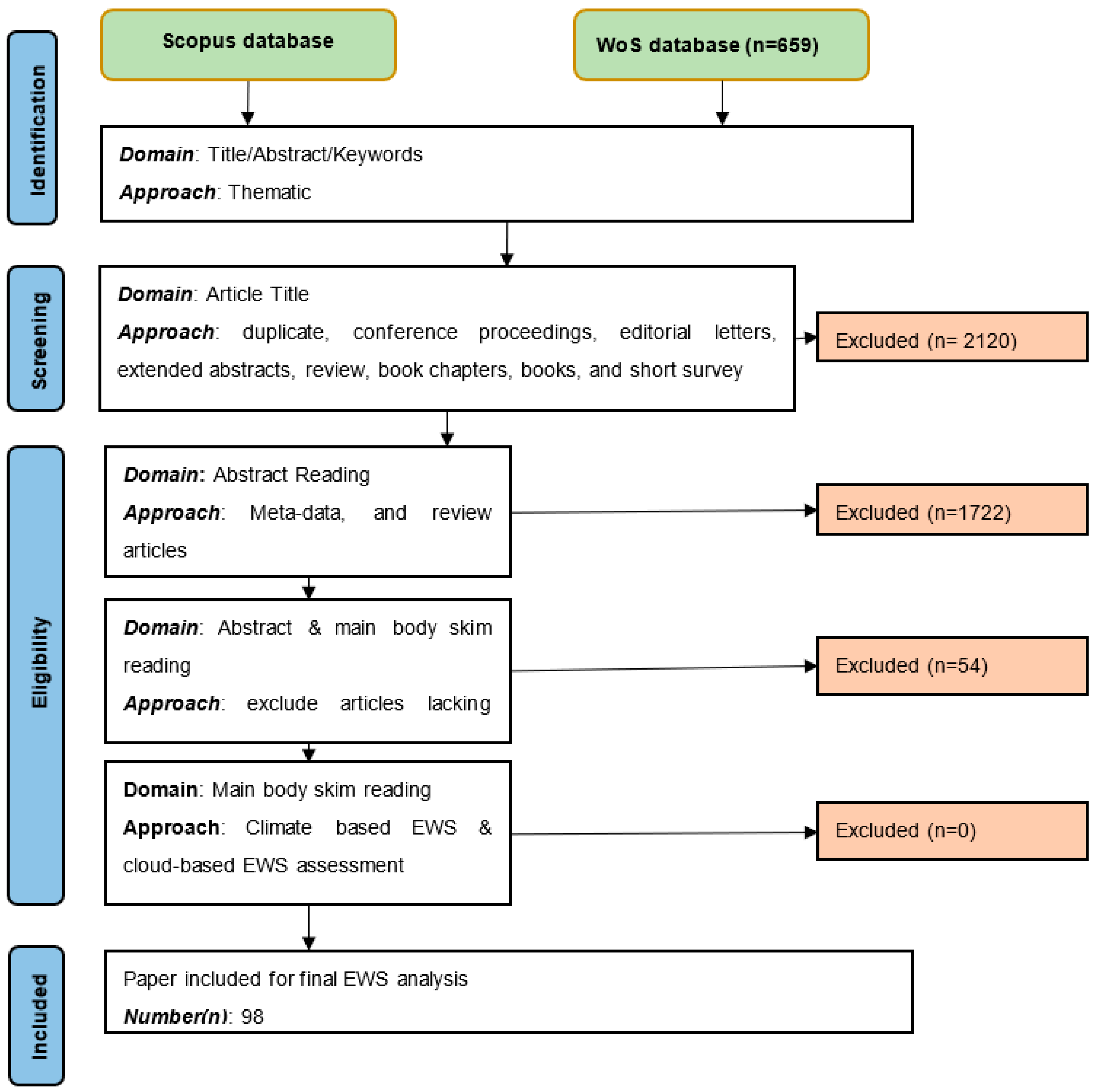
3. Materials and Methods

This study’s methodology is the Protocol Search Appraisal Synthesis Analysis Report (PSALSAR) framework for systematic literature review (SLR) and meta-analysis [51,52]. This method was suitable because it provides a framework that also includes the Preferred Reporting Items for Systematic Reviews and Meta-Analyses (PRISMA) approach, which guided this research to assess existing knowledge of climate-related early warning systems. The systematic literature review helped to identify, evaluate, and synthesize existing literature based on clearly defined inclusion criteria to address the outlined research questions, and the meta-analysis was conducted using simple statistical techniques to find the research output by authors [53]. Table 1 depicts the six steps in the PSALSAR framework for systematic and meta-analysis studies, and these steps guarantee the methodology’s accuracy, systematicity, exhaustiveness, and reproducibility [54], thereby minimising publication bias in the identification and selection of articles. The framework also guided data collection from the data sources for further analysis.

3.1. Protocol

The PICOC framework helped to define the research scope and formulate the key research questions outlined in this study [55]. Table 2 describes the PICOC framework and provides the definition of key aspects of this framework relative to the SLR application.

3.2. Search

This step defines the search string strategy to help identify the relevant literature from online data repositories. The search strings consist of keywords and logical gates to help with the effective filtering of literature and to identify SLR applications. These keywords are the key variables in the research questions. At the same time, the logical gates include “AND”, “OR”, and “NOT” [56]. “AND” unifies the search levels, and “OR” is used for a sequence of synonyms; “NO” limits words that are “messing up” the search of each database. A pilot study was conducted on keywords to refine the search keywords and avoid ambiguity. Keywords can be identified in the document title, abstract, and keywords listed in a publication. The choice of an online data repository depends on the nature of the research topic [57], which also determines its search strategy. Two reviewers worked independently and separately to retrieve articles, which were finalized on 3 March 2023. The articles were restricted between the years 2004 and 2022 from the selected data repositories Scopus and WoS. Scopus is a worldwide peer-reviewed publication. Google Scholar, unlike WoS and Scopus, is limited in terms of publisher list, journal list and types, or information on timespan of records. Though Google Scholar has an advanced search engine for citations not available in other databases [58], it was not considered in this study. The outcome of the search includes the number of available publications, trends, and the fewest research publications on EWS. In this research, the number of articles (n) represents the sample size. Table 3 shows the category of database and search string.
In addition to keywords, inclusion and exclusion criteria were also determined to narrow down the search results to the most relevant paper. Table 4 presents the criteria for article inclusion and exclusion.

3.3. Appraisal

This step involves the selection of articles for further evaluation to identify the relevant paper. Papers might meet the inclusion and exclusion criteria; however, they may not be relevant. Thus, two approaches were conducted: study selection using inclusion criteria and quality assessment. During this step, three independent reviewers screened and reviewed the report presented in a Microsoft Excel template. Differences in opinion were discussed in order to arrive at a consensus on appraisal.
i.
Screening and selection of studies using inclusion criteria:
Literature including extended abstracts, keynotes, presentations, conference proceedings, reviews, and non-English language papers were excluded. A PRISMA flowchart for general screening processes and selection of relevant literature is presented in Figure 1.
The PRISMA flowchart consists of four steps. The identification step is performed using title, abstract, and keywords along the thematic areas. The screening step uses the article’s title to remove duplicates, editorial letters, etc. The eligibility step includes abstract reading and main full-text reading, while the inclusion stage presents all the final papers. All articles that were deemed relevant from the full text were extracted for further quality assessment.
ii.
Quality/risk assessment
The risk assessment was conducted by independent reviewers who verified selected articles to ensure they met the selection criteria. A scaled rating was adopted to measure the quality of selected articles by focusing on key descriptive criteria set in this study. For instance, any article rated as low signifies that the article does not focus on specified criteria. The quality assessment served as a guide to whether each article selected in the final assessment meets all the criteria or not. The first step in the process of quality assessment is that, at each stage of the PRISMA flowchart, articles must meet the specified domain and approach, therefore leading to a number of articles being included and excluded (Figure 1). Secondly, articles included (98 articles) in the final stage of the PRISMA flowchart should meet the criteria in Table 5. Thus, selected articles were deemed as highly focused or otherwise by this study’s independent reviewers. Also, because the articles selected can introduce biases in the systematic literature review, a transparent process in the article selection is needed to minimize bias [59]. Similarly, any differences in opinion can also introduce a bias, which was addressed through an open discussion to reach a consensus. Moreover, the independent reviewers are also mindful of the peer-reviewed journal structure, which in itself is a risk assessment criterion, such that all published papers on WoS or Scopus have already been well scrutinised. This suggests that the published articles have adhered to a journal’s quality assessment standard and that the source of the article can be considered reliable and has scientific merit.

3.4. Synthesis

This step involves data extraction and categorizing relevant literature using the prepared criteria (Table 5). Categorisation helped to organize the data extracted based on variables of interest, the characteristics of the articles, and the criteria used to evaluate the research topic. In this research, the criteria describing the variable of interest by [52] was applied to help synthesise the literature review. Finally, the data on each selected paper was summarised in a Microsoft Excel spreadsheet using the criteria in Table 5.
A systematic literature review seeks to identify articles that meet predefined eligibility criteria; however, this can be compromised when research results from authors are not reported, unavailable, or not indexed, thereby influencing a study’s result by introducing bias in reporting an outcome of a study. Thus, though limiting the type of study to articles that are eligible for inclusion can potentially reduce the risk of bias due to missing results, systematic reviews might suffer from poor indexing, which makes it impossible to identify all studies. Therefore, further topic search on Google was conducted to reduce any bias in reporting.

3.5. Analysis

This involves the evaluation of synthesized data into meaningful information to help address the research questions. The information presented covers both the qualitative and quantitative explanation of the results, discussion, and further direction. The type of statistical tools depends on research findings, hypotheses tested, and the type of statistics reported in the analysis [60]. Descriptive statistics were used to present the publication trends, date of publication, and study coverage and assess indicators of EWSs. An overview of the evidence, knowledge gaps, and research implications were presented based on the selected criteria (see Table 5). Challenges with descriptive analysis include the researcher’s knowledge and understanding of the subject, which can influence personal judgement and future research direction [60]. This limitation with descriptive analysis was also addressed through discussion among the three independent reviewers to arrive at a consensus.

3.6. Report

The report is presented using PRISMA methodology and results summarization. This approach intends to improve the completeness of published articles in meeting the inclusion criteria at each stage of the PRISMA flowchart. Thus, the report is presented using Figures and Tables alongside the qualitative and quantitative description.

4. Results

The results on the PRISMA flowchart (Figure 1) show that at the identification step, a total of 2516 pieces of literature were extracted from the WoS and Scopus. During the screening stage, duplicate pieces of literature were removed using a Microsoft Excel template that enables sorting of rows and columns in ascending order, and literature with “no author name available”, conference papers, editorials, etc., that are not clearly focused on climate EWS assessment were further removed manually by independent reviewers, as these can introduce biases in article selection. Also, articles that were selected (19 articles) without digital object identifier (DOI) were excluded due to the possibility of bias in reporting missing results. Subsequently, a further Google search was conducted on these selected articles without or missing DOI using the article’s topic, which resulted in four articles being retrieved and included in the final analysis. Unfortunately, a request sent directly to the article’s author(s) to make a copy of the full text of their research available yielded no response. Thus, 98 published articles were retained, as they fulfilled all the inclusion criteria. Table 6 shows some studies that appear to meet the inclusion criteria, but because they were not easily assessable, these studies were not retained for the final analysis.
There were 88 articles categorised as non-cloud-based EWSs and 10 cloud-based EWSs. Out of the 88 articles, one article focused on gap analysis of EWSs in general. The findings on the category of EWSs suggest a high number of non-cloud-based EWSs. Thus, 13 (13%) and 22 (22%) selected final articles focused, respectively, on landslides and earthquakes. This result suggests that landslide and earthquake non-cloud-based EWSs have received more attention from researchers. Furthermore, examples of cloud-based EWSs identified in the literature include snowmelt floods (one), drought (one), floods (four), tsunamis (one), and landslides (three). Though there were several natural disaster occurrences, including heat waves, ice storms, dust storms, etc., EWSs for these natural disasters were limited in the data repository considered in this study.
Figure 2 shows the aspect of the EWS framework that the cloud and non-cloud-based EWSs address. Out of the ninety-eight sampled size of literature, forty-seven focused on prediction, while two focused on response mechanisms. This suggests that researchers are focusing their efforts on finding new methods of predicting climate events, with the outcome informing the nature of integration with aspects of the EWS framework.
Table 7 shows that the literature focuses on more than two aspects of the EWS framework. Again, it describes the results of studies that meet the inclusion criteria and the study’s characteristics, focusing on the EWS framework. It is observed that both cloud and non-cloud-based EWSs focus on more than one aspect of the EWS framework. For example, non-cloud-based landslide EWSs combine prediction and monitoring, while cloud-based flood EWSs combine detection and dissemination of warning information. This suggests that EWSs can be designed to detect and, at the same time, disseminate warning information to the affected areas.
Figure 3 shows the use of models to generate data for different EWSs. It is observed that 41 pieces of literature focused on models to generate data for EWSs; some model’s results are validated statistically (eight), other models are validated with historical data (17) or with real-time data (three), and other models are validated with benchmark functions (23). This suggests that models are mostly used to generate data for EWSs, and these models are validated with benchmark functions in order to improve their performance. The limited number of pieces of literature on model validation with real-time data suggests a gap that needs more research.
This study’s result suggests that 57 works of literature focused on computational algorithms, and 41 are not focused on computational algorithms. Thus, the literature on EWSs utilises computational platforms, and it is ideal for harnessing all computational algorithms onto a single platform that can be shared globally.
Figure 4 shows the relevance contribution of reviewed articles, which are categorised into practical, theoretical, policy, and social. It is observed that practical contribution constitutes 72 per cent of the literature, followed by theoretical (6%), policy (5%), and social (13%). This suggests that more emphasis was on the operationality or practicality of EWSs than either theory or policy. Thus, because there are several approaches to practically address emerging climate-related events, it is challenging to create the required policy framework to support EWSs. Furthermore, it is suggestive that theories have been well advanced, and therefore, new implementation approaches are needed.
Appendix A presents the challenges with EWSs and approaches applied to solve those challenges. It is observed that among the challenges with EWS, either non-cloud or cloud-based, include accurate prediction of events using predictive models, collection of climate events data, gaps between the EWS’s message and the public’s response, lack of a global identification/prediction system for the most vulnerable regions, services’ interoperability and open data, etc. Furthermore, current approaches to solving challenges with climate-related EWSs include artificial intelligence, fuzzy logic models, a combination of wavelet transform and particle swarm optimization kernel extreme learning machine, Acoustic Emission techniques, the “Online sequential-extreme learning machine” (OS-ELM) algorithm, recurrent neural networks to build dynamic predictors, use of real-time satellite observations with a database of global terrestrial characteristics, collection of techniques and tools that harnesses the potential of data continuously on a single platform, use of IoT Cloud platform to detection of climate events, etc. This suggests that several approaches or techniques are employed in different EWSs to address emerging issues relating to climate events. Hence, there is a multiplicity of approaches that can be put on a single platform or infrastructure and shared across different EWS frameworks. This demonstrates that more practical approaches were adopted in the design and implementation of EWSs. Though the current approach to resolving the challenge of EWSs has been identified, there is a limited application of the cloud-based service architecture, namely IaaS, PaaS, and IaaS.
The quality assessment of each final article on a fundamental tenet of EWSs using the rating suggests a low (seven), medium (seventy-four), and high (seventeen) focus. Thus, out of the ninety-eight final articles, seven articles were low in quality at describing the fundamental tenets or were not focused on any of the fundamental tenets of EWSs, seventy-four articles were medium in quality, as they focused on only one fundamental tenet of EWSs, and seventeen articles were high in quality, as they focused on more than one fundamental tenet of EWS. This outcome suggests that the extent to which the quality assessment of articles on climate-related EWSs considers more than one fundamental tenet is high.
In terms of cloud-based EWS quality assessment ratings, the record rating is one low, seven medium, and one strong. This result shows that one article was recorded as not focusing on the fundamental tenets of EWSs, seven articles focused on only one fundamental tenet, and one article focused on more than one fundamental tenet of EWSs. These findings suggest that there is a high chance of cloud EWS focusing on only one aspect of the tenet.
In terms of the non-cloud-based EWS, the record rating is six low, sixty-seven medium, and sixteen strong. This result shows that six articles were recorded as not focusing on the fundamental tenets, sixty-seven articles focused on only one fundamental tenet, and sixteen articles focused on more than one fundamental tenet. These findings suggest that there is a high chance of non-cloud EWSs focusing on only one aspect of the tenet. Therefore, both cloud and non-cloud EWSs are more tilted toward focusing on only one aspect of the tenets.

5. Discussion

5.1. Fundamental Tenet of Early Warning Systems

This section discusses the key question that focuses on identifying the underlying approaches and challenges of EWSs. The question of whether existing climate-related EWSs cover more than one aspect of the EWS framework is also addressed. The review suggests that EWSs cover more than one aspect of the EWS framework (Table 7). Again, the review indicates that the aspect of prediction is more dominant than monitoring, detection, dissemination of warning information, and response mechanisms (Figure 2). This demonstrates that there is a drive towards the prediction of climate events, hence the use of models to generate climate data (Figure 2). It reveals that climate models either use historical data or real-time data for model validation (Figure 2).
Secondly, the question on modelling approaches commonly used in assessing existing climate-related EWS effectiveness suggests that different computational approaches were utilised to assess the different aspects of the EWS framework. For example, some predictive models have underlying mathematical models, such as Boussinesq equations, which help in generating the required numerical dataset for the prediction of tsunamis [79], thereby filling the data gap in climate event modelling. Aside from the mathematical model underlying EWSs, some devices have been deployed for the effective monitoring of climate events and the collection of sufficient data for prediction models. The use of devices determines the choice of computational models, and among such devices include the use of IoT and sensor-enabled devices [80,81]. This suggests the possible hybridization of prediction and monitoring approaches to facilitate data processing on EWSs [82], where the hybrid approach uses neural network and heuristic approaches. Aside from hybridisation, EWSs address one or more tenets of the EWS framework (see Table 7), thus providing a multi-dimensional approach to EWS design [79]. For example, Yao, Zeng [31] proposed a landslide EWS that both monitors and predicts landslides. Hsu and Pratomo [67] proposed an earthquake EWS that can predict and disseminate warning information. On the contrary, Zhou, Yin [83] proposed a landslide EWS that only predicts landslide occurrence. Among the papers that address only one aspect of the EWS framework are Zheng, Wang [84] for earthquake prediction, Zhang, Zhang [85] for earthquake detection, and Zhang, Meng [86] for unsafe crew acts (UCAs) detection. Computational models that have been applied in this regard include the Bayesian network (BN) and deep learning models with fully convolutional networks (Table 7). Thus, depending on the focus of EWS, the modelling can focus on addressing one or more aspects of the EWS framework.
Conclusively, the quality assessment report suggests that many EWSs, either non-cloud or cloud-based, focus more on only one fundamental tenet of EWSs. The findings suggest a high chance of cloud EWSs focusing on only one aspect of the fundamental tenet. There is evidence that very few pieces of literature (one article) consider more than one tenet. Similarly, there is a high chance of non-cloud EWSs focusing only on one aspect of the tenet, whereas 16 articles focused on more than one fundamental tenet of non-cloud EWSs. Despite the potential of cloud computing infrastructure, its application is yet to be fully exploited in EWSs toward addressing climate-related risks. Platform dependency limitations might be the reason for having many existing early warning systems focusing on a single tenet.

5.2. Existing Climate-Related Early Warning Systems

This section discusses the question relating to the existing literature on climate-related EWSs, the identification of underlying approaches, and the challenges. Among the key questions raised include whether existing climate-related EWSs use cloud service infrastructure. It is revealed from the literature that many EWSs do not use the cloud-based service infrastructure, and few fall within the cloud computing domain. Again, with the challenges with existing EWSs, it is revealed that early warning systems have challenges that impede their application to climate-related events. Knowing these challenges (Appendix A) helps in finding the most suitable model for assessing the effectiveness of existing climate-related EWSs. The performance of EWS in predicting, monitoring, and sending warning information and responses remains the major challenge. This is because of the uncertainty in estimating parameters that fit a certain threshold, and unfortunately, the performance of this parameter decreases with time, and this affects the performance of EWSs. When existing climate-related non-cloud-based EWSs are unable to process large amounts of data, it impacts their performance. In this regard, the neural network approach remains one of the best approaches to assess the performance or effectiveness of existing climate-related EWSs. For instance, the multi-layer perceptron neural network (MLP-NN) was used to predict tsunamis, with model performance measured by the margin of error in prediction [79]. Altunkaynak and Nigussie [87] combined the wavelet transform (WT) and particle swarm optimization kernel extreme learning machine (PSO-KELM) for predicting daily rainfall with nonlinearity patterns. The internal mechanisms of landslides are very complex, leading to the challenge of having a precise mechanistic model for landslide prediction. Thus, though data-driven models are applicable to predict landslides, the underlying prediction model that is based on feed-forward neural networks can only express the static relationships among data variables; hence, static models are quite limited in landslide prediction tasks. Therefore, application of recurrent neural networks help to build dynamic predictors for landslide prediction [31]. Additionally, machine-learning and satellite remote sensing approaches offer an opportunity to monitor deep-seated landslide deformation and associated processes [88]. Appendix A shows the different approaches to resolving challenges, and it also demonstrates the need to have systematic data and structured data collection and integration techniques [18]. Hence, when a JavaScript library is built into the web browser, it facilitates data collection and enhances user interaction with climate simulation applications.
In addressing the question regarding which type of existing EWS has the highest and the least number of studies, earthquake EWSs have the highest number of works of literature (totalling 22 articles), and the least number of studied EWSs include land falling droughts, sematic, biodiversity, debris flow, surface water quality, algae blooms, unsafe crew acts, air quality, suicide, lightning, thunderstorm, volcano, and flash drought. Landslide EWSs have the second-highest number of works of literature (totalling 13 articles). Yao, Zeng [31] suggest that due to a lack of data on earthquakes and landslides, data-driven models are proposed to address this challenge. Other researchers that also identified data-driven models include landslide detection by Tzouvaras, Danezis [77] and pluvial flood prediction (floodGAN) by Hofmann and Schüttrumpf [89].

5.3. Cloud Computing-Based EWS Opportunities

This section also addresses the key research question regarding the assessment from the literature of the categories of EWSs in cloud computing to identify the approaches, opportunities, and limitations. Based on the question on the current cloud-based EWS, the literature reveals that early warning systems for cloud computing include flood, drought, landslide, and snowmelt flood. Flood EWS has the highest number of studies, accounting for four works of literature (representing 4% of analysed sampled literature), while drought and snowmelt floods both account for the least number (one) (representing 1% of analysed sampled literature). These categories of EWSs use different underlying approaches to model data capture and processing. De Filippis, Rocchi [9] indicate that interoperable web services and the use of open data platforms help customise hydro-climatic information to user’s needs, thus ensuring data capture and storage, data flow management procedures from several data providers, real-time web publication, and service-based information dissemination. For example, EWSs leverage the capability of cloud computing by combining artificial intelligence (AI) and several techniques to predict drought [90]. In terms of tsunamis, an EWS named INSPIRE leverages cloud computing capability for the simulation of tsunamis [91]. With respect to flood, computer vision with image processing functionality was embedded in an IoT cloud platform for flood prediction [92]. It can be identified from the reviewed literature that few EWSs deployed on the cloud computing environment could not specifically indicate the service infrastructure, either IaaS, PaaS, or software as a service (SaaS). This notwithstanding, the cloud service’s infrastructure, such as IaaS, PaaS and SaaS, offers unique opportunity to creating a uniform service infrastructure for multiplicity of approaches or techniques.
Regarding the modelling approaches commonly used in measuring the effectiveness of cloud-based EWSs, this review shows that these approaches used in the categorised EWSs (Table 7) offer an opportunity for real-time data processing of satellite observation databases globally [93]. This review shows that there is an application, referred to as DataOps, that combines different techniques and tools onto a single platform that continuously harnesses data on climate information for sharing on web platforms [90]. The IoT cloud computing platform offers an opportunity to monitor and analyse flood images through cloud computer vision with image processing models. Also, LoRa technology in cloud computing frameworks helps customise sensors and gateway devices because of their low energy consumption capabilities [80]. The web environment offers the needed tools for data collection and remote control, which enables technical maintenance and calibration of sensors [20]. Galaz, Cienfuegos [94] indicate that since web browsers can have an inbuilt JavaScript library, it can facilitate consistent data gathering and analysis to support global observation of climate-related events [94]. Cloud services bridge the gap between scientific research on warning and preparedness of institutions and communities [91]. Despite these opportunities, there appears to be very limited literature regarding the use of cloud service infrastructure for climate-related EWSs. Artificial intelligence and machine learning are the common modelling approaches in the processing of climate-related data. While these approaches are relevant, their performance measures the effectiveness of the approach.
It is crucial to note that there is a body of evidence that 88 early warning systems are non-cloud-based while 10 are cloud-based. This outcome suggests a lack of usage of the cloud computing infrastructure despite its benefits. Despite the opportunities of cloud computing, the limitations of cloud computing include data governance [42], which indicates that the structure of data collected, stored, and used in an organization needs to be aligned with the cloud service infrastructure. The fact that no one computational algorithm fits all data models creates a computational challenge that impacts the performance of the computational approaches. Again, since there are different data-driven models with different underlying techniques that help in predicting and monitoring climate conditions, it shows that performance can be a limiting factor [95]. Thus, the performance matrix can create the needed value chain for data governance [43]. The literature review indicates that cloud computing climate-related EWSs can cover multiple aspects of the EWS framework (Table 7), for example, combining prediction and monitoring or detection and dissemination of warning information.
With cloud computing, data can be stored anywhere and accessed via the internet; thus, cloud computing EWSs are more resilient to failure and still remain operational. Unfortunately, the cost of deploying cloud service infrastructure can be a limitation towards its use, and this calls for more funding from international climate-focused organizations. Fortunately, the cost associated with purchasing hardware can be eliminated when the cloud computing infrastructure is adopted in the development of EWSs. Another limitation to cloud computing EWSs is that since data is stored redundantly, it could raise security and privacy concerns. Thus, an organization may adopt using government-hosted cloud computing service infrastructures to ensure compliance. Though commercial-hosted cloud computing service infrastructures can provide a distributed data storage system to operationalize EWSs, contractual issues, and vendor lock-ins could negatively impact access to commercial cloud-hosted EWSs. EWSs should be accessed by every person irrespective of their geographical location; however, developing countries with inadequate internet infrastructure and technological skills can negatively impact global access to EWSs.
Figure 4 shows that more attention is on the operation of EWSs, in which there are more non-cloud-based EWSs than cloud-based EWSs. It could be inferred in terms of the level of maturity that non-cloud-based EWSs could reach either the intermediate or advanced adoption stage, whereas cloud-based EWSs could either be in the foundational stage or intermediate stage. This suggests further research in assessing the level of maturity relative to cloud-based EWSs.

6. Limitations, Practical and Policy Implications

This study’s limitation is the choice of the methodology adopted, which includes documents written in another language apart from the English language not being considered, even though they might have useful and relevant information that could be beneficial to this study. Secondly, documents written prior to 2003 were also not considered despite the relevant information they might contain. Thirdly, the use of the Boolean operator (AND) in the search criteria in the online repository could not yield any information, for example, cloud computing AND early warning systems. The choice of Scopus and WoS as data sources was also the study’s limitation because of the likelihood that other data sources might have relevant articles that can be useful for this study. However, the 2516 works of literature that were extracted, screened, and reduced to 98 pieces of literature were helpful in overcoming this data source limitation.
Practically, this research has identified climate-related EWSs, which are categorised into cloud and non-cloud-based. This classification could help policymakers in knowing the most dominant climate-related EWSs deployed using the cloud computing service infrastructure. In terms of policy, since the cloud computing service infrastructure can be openly accessed, it has the potential to substantially increase the access and availability of climate-related EWSs to support the 2030 vision agenda. Again, policymakers should consider developing the needed legislative framework to support cloud-based climate-related EWSs. This research provides the basis for policymakers to engage EWS design practitioners about the prospects of migrating non-cloud EWSs to cloud infrastructure.

7. Conclusions

This research reviewed recent literature on existing early warning systems’ challenges and opportunities for cloud computing early warning systems. Through this systematic literature review, several EWSs were identified and categorised into cloud and non-cloud. While the cloud computing framework offers a service infrastructure to enable a shared pool of computing resources, the existing EWSs use a server-client computing structure that allows the sharing of limited resources, including storage and processing capabilities. The findings indicate that few EWSs, including flood, drought, landslide, and snowmelt flood, utilise the cloud computing infrastructure, whereas many EWSs either are not leveraging the capability of cloud computing infrastructure or are online platforms that do not utilise the cloud computing service infrastructure. Secondly, few EWSs harness several techniques and tools, such as artificial intelligence techniques, onto a single platform for data processing. Thirdly, sensor capabilities and IoT devices have also been deployed on cloud computing platforms to facilitate data capture for different kinds of natural disaster occurrences. Fourthly, data-generated models that are used in EWSs are often validated using historical data or real-time data. The fact that models are mostly used in generating data for climate-related EWSs, which are then validated with benchmark functions, indicates the reuse of models rather than developing new computational models, which might be time-consuming. Thus, the cloud-based computing infrastructure facilitates climate-related model reuse through its resource-sharing capabilities. Lastly, several challenges with climate-related EWSs were identified and categorised into non-cloud and cloud computing-based systems. These findings contribute significantly toward enhancing the use of early warning systems in vulnerable communities because of the easy-to-access uniform cloud service infrastructure that can perform different climate event simulations. Again, it contributes toward helping EWS practitioners distinguish cloud and non-cloud-based applications and strive toward a cloud computing framework because of the benefits of ensuring resource sharing.

Author Contributions

I.E.A.—idea conceptualization, methodology, software, writing—original draft; J.B.—writing—original draft; T.M.—writing—reviewing and editing, funding acquisition, supervision; M.M.—writing—original draft. All authors have read and agreed to the published version of the manuscript.

Funding

This research was funded by the Government of Flanders through the Integrated Climate-Driven Multi-Hazard Early Warning Systems (ICMHEWS) Project between the South Africa Weather Service (SAWS), the Central University of Technology (CUT) and the University of KwaZulu-Natal (UKZN). The Adaptation Fund is acknowledged for funding through the uMngeni Resilience Project.

Data Availability Statement

Anonymised data are available by contacting the authors.

Conflicts of Interest

The authors declare no known competing financial interests or personal relationships that could have appeared to influence the work reported in this paper.

Appendix A. Challenges with Climate-Related EWSs and Approach to Resolve Challenges

No:#AuthorsYearNature of Climate EventChallenge with EWS (Cloud and Non-Cloud)Current ApproachNon-CloudCloud
1. Zhou, Yin [83]2018LandslideRandom fluctuation of prediction results and inaccurate prediction when step-like deformations happen.Combination of the Wavelet Transform (WT) and “Particle Swarm Optimization-Kernel Extreme Learning Machine (PSO-KELM)” methods and the landslide causal factors. x
2. Zheng, Wang [84]2022EarthquakeCollection of seismic data.Seismic data collection using smartphones to develop a smartphone-based earthquake early warning system. Again, signal-processing techniques and machine-learning algorithms were applied to sensor data for monitoring earthquakes. x
3. Zhang, Zhang [85]2021EarthquakeEarly reporting of earthquake location and magnitude to mitigate seismic hazards. A deep learning approach that uses fully convolutional networks to simultaneously detect earthquakes and estimate source parameters in real-time.x
4. Zhang, Meng [86]2022Unsafe crew acts (UCAs)Gaps exist between prediction models developed by researchers and those adopted by practitioners in predicting unsafe crew acts.A Bayesian network (BN) based approach called “Standardized Plant Analysis Risk–HumanReliability Analysis (SPAR-H)” was applied to predict the probability of seafarers’ unsafe acts. The practicability of SPAR-H and theforward and backward inference functions of BN were applied to evaluate the probabilistic risk of unsafe acts and PSFs.x
5. Zhang, Qiao [96]2021EarthquakeA gap existed between the EEWS’s message and the public’s response.Public participation and training people to be proactive towards warning messages.x
6. Zaki, Chai [97]2014LandslideObtaining data from deforming soil bodies, which are deep lying due to a high level of attenuation and to signal contamination by ambient noise. Acoustic Emission techniques for soil slope monitoring.x
7. Yuan, Wang [23]2019Flash droughtsFlash drought risk change in a warming future climate remains unknown due to a diversity of flash drought definitions, unclear role of anthropogenic fingerprints, and uncertain socioeconomic development. New method for explicitly characterizing flash drought eventsx
8. Yuan, Tu [98]2021Flash floodA single rainfall pattern is inconsistent with the actual diversified rainfall process, thus creating a challenge with early warning of flash floods.Cumulative distribution functions (CDFs) were applied to fit the cumulative rainfall-duration curves corresponding to typical rainfall processes and the probability density functions (PDFs). Afterwards, the HEC-HMS hydrological model is applied to simulate the rainfall-runoff process, and the critical rainfall corresponding to different characteristic rainfall patterns is calculated with a trial algorithm. x
9. Yuan, Liu [99]2019Flash droughtsSudden occurrence and randomness of heavy rainstorms in hilly areas pose challenges to the identification of early warning indicators for mountain flash floods. The HEC-HMS model was applied to simulate the rainfall-runoff process and determine the early warning indicators under different rainfall patterns through repeated trial calculations. x
10. Yao, Yang [79]2021TsunamiModelling of tsunami wave interaction with coral reefs to date focuses mainly on process-based numerical models.A numerical model based on the Boussinesq equations is applied to provide a dataset for MLP-NN training and testing. x
11. Yao, Zeng [31]2015LandslideLandslide early warning systems can be implemented by monitoring and predicting landslide displacements. The challenge is the complexity of the internal mechanisms of landslides, and precise mechanistic models of landslides are difficult to obtain. Therefore, data-driven models are usually applied because traditional models, such as feed-forward neural networks, can only express static relationships; the applicability of these static models is quite limited in landslide prediction tasks.Recurrent neural networks are used to build dynamic predictors of landslide displacement using a training algorithm named reservoir computing. x
12. Yang, Robert [93]2010Flood and landslideLack of a global flood/landslide identification/prediction system for the most vulnerable regions. Combining real-time satellite observations with a database of global terrestrial characteristics. x
13. Yang, Chen [100]2021Algae bloomsThe threat of algal blooms on water resources and their early detection remains a challenge in eutrophication management worldwide. Fuzzy logic has become a robust tool for establishing early warning systems. Application of a fuzzy logic model driven by biochemical data sampled by two auto-monitoring sites and numerically simulated velocity.x
14. Tamburri, van Mierlo [90]2022DroughtData deluge grows exponentially; however, data utilisation is not growing at the same pace. DataOps represents a set of techniques and tools that are used to harness the potential of data continuously whilst incrementally using complex cloud systems orchestration techniques. x
15. Srivihok, Honda [91]2014TsunamiLack of an effective end-to-end tsunami early warning system to connect scientific components of warning with the preparedness of institutions and communities to respond to an emergency.An online tool called “INSPIRE” to help in tsunami inundation simulation and loss estimation. x
16. Soh, Razak [92]2022FloodThe challenge with detecting riverbank level and river water level.A system that monitors the river water level by using computer vision with image processing and IoT Cloud platforms to detect riverbank level and river water level. x
17. Restrepo-Estrada, de Andrade [101]2018FloodA gap in research with regard to the use of social media as a proxy for rainfall-runoff estimations and flood forecasting.Applied transformation function for the proxy variable for rainfall by analysing “geo-social” media messages and rainfall measurements from authoritative sources, which are later incorporated within a hydrological model for streamflow estimation.x
18. Raziei and Fatahi [102]2011DroughtLack of updated and reliable meteorological data in a data-scarce region.Applied NCEP/NCAR gridded precipitation dataset for drought monitoring. Additionally, Principal Component Analysis (PCA) coupled with Varimax rotation to the SPI field of SPI-6 and SPI-12 for both NCEP/NCAR and observational datasets was applied.x
19. Pandeya, Uprety [103]2021FloodExisting data gaps represent the main bottleneck for establishing an effective community-based flood early warning system in a data-scarce region.Applied a citizen science-based hydrological monitoring approach in which we tested low-cost river-level sensors. x
20. Madruga De Brito, Kuhlicke [104]2020DroughtContemporary drought impact assessments have been constrained due to data availability, leading to an incomplete representation of impact trends. Near-real-time monitoring of drought socio-economic impacts based on media reports. Additionally, text mining techniques were employed for impact statement identification relating to livestock, agriculture, forestry, fires, recreation, energy, and transport sectors. x
21. Chai, Luo [105]2019SuicideLack of an effective system to identify suicide-related media reporting.Google Trends and suicide-related media reporting. x
22. Jin, Cai [106]2019Surface water qualityDeterioration of surface water quality in real-time.Data-driven model for surface water quality prediction and provide real-time early warnings according to the historical observation data. Integrated with Genetic algorithm to optimize initial weight parameters. BPNN is used to adjust appropriate connection architectures and identify features of water quality variation in real-time early warning. x
23. De Filippis, Rocchi [9]2022FloodServices interoperability and open data are not common in local systems implemented in developing countries.Web platform and related services developed for the Local Flood Early Warning System of the Sirba River in Niger (SLAPIS) to tailor hydroclimatic information to the user’s needs, both in content and format. This platform uses open-source software components and interoperable web services to create a software framework for data capture and storage, data flow management procedures from several data providers, real-time web publication, and service-based information dissemination. x
24. Fang, Xu [107]2015Snowmelt floodLack of integrated system for snowmelt flood management. Developing a prototype integrated system for snowmelt flood early warning in water resource management.Develop a prototype integrated information system (IIS) for snowmelt flood early warning with the combination of IoT, Geoinformatics and Cloud Service. x
25. Frigerio et al. [20]2014LandslideLack of integrated services adopted for the design and the realization of a web-based platform for automatic and continuous monitoring of the Rotolon landslide.Use a web environment for data collection and a remote control permits technical maintenance and calibration of instruments and sensors.x
26. Jiang, Li [82]2019Air pollutionCurrent early warning systems rarely focus on the mining of pollutant characteristics and their corresponding scientific evaluation.A hybrid forecasting model was proposed combined with an advanced data processing technique—a neural network and a new heuristic algorithm. x
27. Sharma, Deo [108]2020Air qualityLack of effective framework to emulate hourly air quality variables.Online sequential-extreme learning machine (OS-ELM) algorithm integrated with improved complete ensemble empirical mode decomposition with adaptive noise (ICEEMDAN) is designed as a data pre-processing system to robustly extract predictive patterns and fine-tune the model generalization to a near-optimal global solution, which represents modelled air quality at hourly forecast horizons. x
28. Xu, Yang [109]2017Air qualityLack of a model to predict daily air pollution.The hybrid forecasting model is based on the theory of “decomposition and ensemble” and combined with the advanced data processing technique, support vector machine, bio-inspired optimization algorithm and the leave-one-out strategy for deciding weight. x
29. Pramanik, Samal [81]2022Air qualityThe traditional approach of air quality monitoring involves large and expensive scientific equipment permanently installed. Designed an IoT-enabled ambient air quality monitoring system to track the presence of toxic gaseous elements in real-time.x
30. Chieochan, Saokaew [110]2013Debris flowDebris flow detection systems, like wireless sensors, satellite images, and radar, are not suitable for general public use. Use of computer vision technique to build a simulation environment.x
31. Mandl, Frye [111]2013EarthquakeLack of integrated system to couple loosely collaborated sensor systems for a variety of space, airborne, and ground sensors. Use of “SensorWeb” that comprised heterogeneous sensors tied together with an open messaging architecture and web services.x
32. Böse et al. [70]2008EarthquakeThe major challenge in the development of earthquake early warning (EEW) systems is the achievement of robust performance at the largest possible warning time. PreSEIS (Pre-SEISmic) was developed based on single station observations and, at the same time, shows higher robustness. The neural network-based approach was used in parameter estimation.x
33. Iaccarino, Gueguen [26]2021EarthquakePredicting the structural drift for On-site Earthquake Early Warning (EEW) applications.Linear least square regression (LSR) and four non-linear machine-learning (ML) models.x
34. Yucel and Onen [112]2014RainfallDifficulties in estimating precipitation impose an important limitation on the possibility and reliability of hydrologic forecasting and early warning systems.Weather Research and Forecasting (WRF) model and the Multi Precipitation Estimates (MPE) algorithm.x
35. Ritter, Berenguer [71]2020Flash floodFlash floods evolve rapidly in time, which poses particular challenges to emergency managers.A method named ReAFFIRM that uses gridded rainfall estimates was used to assess in real-time the flash flood hazard and translate it into the corresponding impacts.x
36. Watanabe, Koyama [72]2021ForestThe challenge with monitoring forests in tropical regions in real-time.An automatic change detection method for near real-time (NRT) forest monitoring based on L-band ALOS-2/PALSAR-2 ScanSAR HH, HV, and HH/HV ratio was used to detect various deforestation stages based on their different radar scattering characteristics.x
37. Spruce, Sader [113]2011ForestChallenges with detecting forest defoliation by gipsy moth outbreaks.Use of MODIS data for determining near real-time defoliation.x
38. Altunkaynak and Nigussie [87]2015Rainfall Because of its nonlinearity, prediction of daily rainfall with high accuracy and long prediction lead time is difficult.Two methods called combined season-multilayer perceptron (SAS-MP) and hybrid wavelet-season-multilayer perceptron (W-SAS-MP) were developed to enhance prediction accuracy and extend prediction lead time of daily rainfall up to 5 days.x
39. Hofmann and Schüttrumpf [75]2020Pluvial floodThe effective forecast and warning of pluvial flooding in real-time is one of the key elements and remaining challenges of integrated urban flood risk management. Risk-based solutions and 2D hydrodynamic models are used in the early warning process. Additionally, distributed computing of hydrologic independent models was employed over high computational times of hydrodynamic simulations.x
40. Hofmann and Schüttrumpf [89]2021Pluvial floodRecent approaches have used mainly conventional fully connected neural networks, which were (a) restricted to spatially uniform precipitation events and (b) limited to a small amount of input data.Data-driven models that utilizes deep convolutional generative adversarial network are used to predict pluvial flooding caused by nonlinear spatial heterogeny rainfall events. The model developed, floodGAN, is based on an image-to-image translation approach whereby the model learns to generate 2D inundation predictions conditioned by heterogenous rainfall distributions.x
41. Thiery, Gudmundsson [95]2017ThunderstormsEvery year, intense nighttime thunderstorms cause numerous boating accidents on the lake, resulting in thousands of deaths among fishermen. Satellite data-driven storm prediction system, the prototype Lake Victoria Intense Storm Early Warning System (VIEWS).x
42. Qing, Zeng [114]2022TornadoApplying machine-learning algorithms to detect tornadoes usually encounters class imbalance problems because tornadoes are rare events in weather processes. ADASYN-LOF algorithm (ALA) was used to solve the imbalance problem of tornado sample sets based on radar data. x
43. Sayad, Mousannif [115]2019WildfiresChallenge with data set to model wildfire prediction.Used Remote Sensing data related to the state of the crops (NDVI) and meteorological conditions (LST), as well as the fire indicator “Thermal Anomalies” acquired from “MODIS” (Moderate Resolution Imaging Spectroradiometer), to build a model for wildfire prediction. Experiments were made using the big data platform “Databricks”.x
44. van Natijne, Lindenbergh [88]2020LandslideNowcasting and early warning systems for landslide hazards have been implemented mostly at the slope or catchment scale. These systems are often difficult to implement at a regional scale or in remote areas.Machine-learning and satellite remote sensing products offer new opportunities for both local and regional monitoring of deep-seated landslide deformation and associated processes. x
45. Tzouvaras, Danezis [77]2020LandslideLack of data-driven model for landslide detection.Used Copernicus open-access and freely distributed datasets along with open-source processing software SNAP (Sentinel’s Application Platform) for landslide detection triggered by heavy rainfall.x
46. Bagwari, Roy [80]2022LandslideData changes in the monitoring area may be noticed in many days, months, or years, depending on the weather characteristics. Therefore, a frequent and large amount of data from the monitored area is not required to be sent to a cloud server.Use of LoRa technology to design a customized sensor node and gateway node to monitor the changes periodically with low energy power consumption. x
47. Galaz, Cienfuegos [94]2022TsunamiTsunami simulation software has inherent complexities in phases of installation, execution, and pre- and post-processing that prevent its use in other areas of risk management, such as communication and education.A JavaScript library built into a web browser to facilitate data gathering and analyses from tsunami simulations by means of interactive and efficient visualizations.
x

References

  1. World Meteorological Organization. WMO Bulletin: Early Warning and Anticipatory Action. Available online: https://public.wmo.int/en/media/news/wmo-bulletin-early-warning-and-anticipatory-action (accessed on 5 April 2023).
  2. World Meteorological Organization. Early Warnings for All initiative Gains Momentum. Available online: https://public.wmo.int/en/media/press-release/early-warnings-all-initiative-gains-momentum (accessed on 5 April 2023).
  3. International Telecommunication Union. Early Warning Systems for All by 2027. Available online: https://www.itu.int/hub/2023/03/early-warning-systems-for-all-by-2027/ (accessed on 5 April 2023).
  4. Boelee, L.; Lumbroso, D.M.; Samuels, P.G.; Cloke, H.L. Estimation of uncertainty in flood forecasts—A comparison of methods. J. Flood Risk Manag. 2019, 12, e12516. [Google Scholar] [CrossRef]
  5. Perera, D.; Seidou, O.; Agnihotri, J.; Rasmy, M.; Smakhtin, V.; Coulibaly, P.; Mehmood, H. Flood Early Warning Systems: A Review of Benefits, Challenges and Prospects; United Nations University Institute for Water, Environment and Health (UNU-INWEH): Hamilton, ON, Canada, 2019; p. 30. [Google Scholar]
  6. Dutta, R.; Basnayake, S. Gap assessment towards strengthening early warning systems. Int. J. Disaster Resil. Built Environ. 2018, 9, 198–215. [Google Scholar] [CrossRef]
  7. Meng, X.; Feng, L. Research on application of internet of things technology to earthquake prevention and disaster reduction. World Inf. Earthq. Eng. 2014, 30, 129–133. [Google Scholar]
  8. Esposito, M.; Palma, L.; Belli, A.; Sabbatini, L.; Pierleoni, P. Recent Advances in Internet of Things Solutions for Early Warning Systems: A Review. Sensors 2022, 22, 2124. [Google Scholar] [CrossRef]
  9. De Filippis, T.; Rocchi, L.; Massazza, G.; Pezzoli, A.; Rosso, M.; Ibrahim, M.H.; Tarchiani, V. Hydrological Web Services for Operational Flood Risk Monitoring and Forecasting at Local Scale in Niger. ISPRS Int. J. Geo-Inf. 2022, 11, 236. [Google Scholar] [CrossRef]
  10. Calvello, M.; Piciullo, L. Assessing the performance of regional landslide early warning models: The EDuMaP method. Nat. Hazards Earth Syst. Sci. 2016, 16, 103–122. [Google Scholar] [CrossRef]
  11. Jacks, E.; Davidson, J.; Wai, H.G. Guidelines on Early Warning Systems and Application of Nowcasting and Warning Operations; World Meteorological Organization (WMO): Geneva, Switzerland, 2010; pp. 1–25. [Google Scholar]
  12. Rödder, S.; Schaumann, F. It’s something that I do every day. Exploring interdisciplinarity and stakeholder engagement in tsunami science. Front. Earth Sci. 2022, 10, 949803. [Google Scholar] [CrossRef]
  13. Trogrlić, R.Š.; Homberg, M.v.d.; Budimir, M.; McQuistan, C.; Sneddon, A.; Golding, B. Early Warning Systems and Their Role in Disaster Risk Reduction. In Towards the “Perfect” Weather Warning; Golding, B., Ed.; Spring: Cham, Switzerland, 2022; pp. 11–46. [Google Scholar] [CrossRef]
  14. Marin-Ferrer, M.; Poljansek, K.; Vernaccini, L. Index for risk management—INFORM: Concept and methodology, version 2017. Jt. Res. Cent. (Eur. Comm.) 2017. Available online: http://op.europa.eu/en/publication-detail/-/publication/b1ef756c-5fbc-11e7-954d-01aa75ed71a1/language-en/format-PDF (accessed on 10 December 2022).
  15. Chanza, N.; Siyongwana, P.Q.; Williams-Bruinders, L.; Gundu-Jakarasi, V.; Mudavanhu, C.; Sithole, V.B.; Manyani, A. Closing the gaps in disaster management and response: Drawingng on local experiences with Cyclone Idai in Chimanimani, Zimbabwe. Int. J. Disaster Risk Sci. 2020, 11, 655–666. [Google Scholar] [CrossRef]
  16. Perera, D.; Agnihotri, J.; Seidou, O.; Djalante, R. Identifying societal challenges in flood early warning systems. Int. J. Disaster Risk Reduct. 2020, 51, 101794. [Google Scholar] [CrossRef]
  17. Perera, C.; Jayasooriya, D.; Jayasiri, G.; Randil, C.; Bandara, C.; Siriwardana, C.; Dissanayake, R.; Hippola, S.; Sylva, K.; Kamalrathne, T.; et al. Evaluation of gaps in early warning mechanisms and evacuation procedures for coastal communities in Sri Lanka. Int. J. Disaster Resil. Built Environ. 2020, 11, 415–433. [Google Scholar] [CrossRef]
  18. Wilkins, A.; Pennaz, A.; Dix, M.; Smith, A.; Vawter, J.; Karlson, D.; Tokar, S.; Brooks, E. Challenges and opportunities for Sendai framework disaster loss reporting in the United States. Prog. Disaster Sci. 2021, 10, 100167. [Google Scholar] [CrossRef]
  19. Collins, M.L.; Kapucu, N. Early warning systems and disaster preparedness and response in local government. Disaster Prev. Manag. 2008, 17, 587–600. [Google Scholar] [CrossRef]
  20. Frigerio, S.; Schenato, L.; Bossi, G.; Cavalli, M.; Mantovani, M.; Marcato, G.; Pasuto, A. A web-based platform for automatic and continuous landslide monitoring: The Rotolon (Eastern Italian Alps) case study. Comput. Geosci. 2014, 63, 96–105. [Google Scholar] [CrossRef]
  21. Huntington, J.L.; Hegewisch, K.C.; Daudert, B.; Morton, C.G.; Abatzoglou, J.T.; McEvoy, D.J.; Erickson, T. Climate Engine: Cloud Computing and Visualization of Climate and Remote Sensing Data for Advanced Natural Resource Monitoring and Process Understanding. Int. J. Appl. Earth Obs. Geoinf. 2017, 98, 2397–2410. [Google Scholar] [CrossRef]
  22. Hannaford, J.; Collins, K.; Haines, S.; Barker, L.J. Enhancing drought monitoring and early warning for the United Kingdom through stakeholder coinquiries. Weather Clim. Soc. 2019, 11, 49–63. [Google Scholar] [CrossRef]
  23. Yuan, X.; Wang, L.; Wu, P.; Ji, P.; Sheffield, J.; Zhang, M. Anthropogenic shift towards higher risk of flash drought over China. Nat. Commun. 2019, 10, 4661. [Google Scholar] [CrossRef]
  24. Huang, D.; Wang, G.; Jin, F. Performance of On-Site Earthquake Early Warning System Using Strong-Motion Records from Recent Earthquakes. Nat. Hazards Rev. 2019, 20, 4018030. [Google Scholar] [CrossRef]
  25. Medina, M.; Sanchez, R.; Riquelme, S.; Flores, M.C.; Koch, P.; Bravo, F.; Barrientos, S.; Henson, I.; Chung, A.; Melgar, D.; et al. An Earthquake Early Warning System for Northern Chile Based on Elarm S-3. Seismol. Res. Lett. 2022, 93, 3337–3347. [Google Scholar] [CrossRef]
  26. Iaccarino, A.G.; Gueguen, P.; Picozzi, M.; Ghimire, S. Earthquake Early Warning System for Structural Drift Prediction Using Machine Learning and Linear Regressors. Front. Earth Sci. 2021, 9, 666444. [Google Scholar] [CrossRef]
  27. Yamada, M.; Chen, D.Y. Automatic hypocenter determination with the IPFx method for the 2018 Hualien earthquake sequence. Terr. Atmos. Ocean. Sci. 2022, 33, 18. [Google Scholar] [CrossRef]
  28. Wannachai, A.; Aramkul, S.; Suntaranont, B.; Somchit, Y.; Champrasert, P. HERO: Hybrid Effortless Resilient Operation Stations for Flash Flood Early Warning Systems. Sensors 2022, 22, 4108. [Google Scholar] [CrossRef] [PubMed]
  29. Vanderkimpen, P.; Rocabado, I.; Cools, J.; El-Sammany, M.; Abdelkhalek, A. FlaFloM—An early warning system for flash floods in Egypt. WIT Trans. Ecol. Environ. 2010, 133, 193–202. [Google Scholar]
  30. Mendoza-Cano, O.; Aquino-Santos, R.; López-De la Cruz, J.; Edwards, R.M.; Khouakhi, A.; Pattison, I.; Rangel-Licea, V.; Castellanos-Berjan, E.; Martinez-Preciado, M.A.; Rincón-Avalos, P.; et al. Experiments of an IoT-based wireless sensor network for flood monitoring in Colima, Mexico. J. Hydroinform. 2021, 23, 385–401. [Google Scholar] [CrossRef]
  31. Yao, W.; Zeng, Z.; Lian, C.; Tang, H. Training enhanced reservoir computing predictor for landslide displacement. Eng. Geol. 2015, 188, 101–109. [Google Scholar] [CrossRef]
  32. Ginkel, M.v.; Biradar, C. Drought Early Warning in Agri-Food Systems. Climate 2021, 9, 134. [Google Scholar] [CrossRef]
  33. Núñez, J.; Catalán, P.A.; Valle, C.; Zamora, N.; Valderrama, A. Discriminating the occurrence of inundation in tsunami early warning with one-dimensional convolutional neural networks. Sci. Rep. 2022, 12, 10321. [Google Scholar] [CrossRef]
  34. Mishra, A.K.; Desai, V.R. Drought Forecasting Using Feed-forward Recursive Neural Networks. Ecolo. Model 2006, 198, 127–138. [Google Scholar] [CrossRef]
  35. Almikaeel, W.; Cubanová, L.; Šoltész, A. Hydrological Drought Forecasting Using Machine Learning—Gidra River Case Study. Water 2022, 14, 387. [Google Scholar] [CrossRef]
  36. Böse, M.; Smith, D.E.; Felizardo, C.; Meier, M.A.; Heaton, T.H.; Clinton, J.F. FinDer v.2: Improved real-time ground-motion predictions for M2-M9 with seismic finite-source characterization. Geophys. J. Int. 2018, 212, 725–742. [Google Scholar] [CrossRef]
  37. Brust, C.; Kimball, J.S.; Maneta, M.P.; Jencso, K.; Reichle, R.H. DroughtCast: A Machine Learning Forecast of the United States Drought Monitor. Front. Big Data 2021, 4, 1–16. [Google Scholar] [CrossRef] [PubMed]
  38. Sutanto, S.J.; Van Lanen, H.A.J.; Wetterhall, F.; Llort, X. Potential of Pan-European Seasonal Hydrometeorological Drought Forecasts Obtained from a Multihazard Early Warning System. Am. Meteorol. Soc. 2020, 101, E368–E393. [Google Scholar] [CrossRef]
  39. Peng, C.; Jiang, P.; Ma, Q.; Su, J.; Cai, Y.; Zheng, Y. Chinese Nationwide Earthquake Early Warning System and Its Performance in the 2022 Lushan M6.1 Earthquake. Remote Sens. 2022, 14, 4269. [Google Scholar] [CrossRef]
  40. Ahmed, S.T.; Khadhim, B.J.; Kadhim, Q.K. Cloud Services and Cloud Perspectives: A Review. IOP Conf. Ser. Mater. Sci. Eng. 2021, 1090, 012078. [Google Scholar] [CrossRef]
  41. Behbehani, D.; Komninos, N.; Al-Begain, K.; Rajarajan, M. Cloud Enterprise Dynamic Risk Assessment (CEDRA): A dynamic risk assessment using dynamic Bayesian networks for cloud environment. J. Cloud Comput. 2023, 12, 79. [Google Scholar] [CrossRef]
  42. Walsh, M.J.; McAvoy, J.; Sammon, D. Grounding data governance motivations: A review of the literature. J. Decis. Syst. 2022, 31, 282–298. [Google Scholar] [CrossRef]
  43. Yukhno, A. Digital Transformation: Exploring big data Governance in Public Administration. Public Organiz. Rev. 2022, 1–15. [Google Scholar] [CrossRef]
  44. Anju Pillai, S.; Chandraprasad, G.S.; Khwaja, A.S.; Anpalagan, A. A Service Oriented IoT Architecture for Disaster Preparedness and Forecasting System. Internet Things 2019, 14, 100076. [Google Scholar] [CrossRef]
  45. Ababneh, H. Extending the Technology Acceptance Model and Critical Success Factors Model to Predict the Use of Cloud Computing. J. Inf. Technol. Res. (JITR) 2016, 9, 17. [Google Scholar] [CrossRef]
  46. Amron, M.T.; Ibrahim, R.; Bakar, N.A.A.; Chuprat, S. Determining Factors Influencing the Acceptance of Cloud Computing Implementation. Proceedings of The Fifth Information Systems International Conference, Surabaya, Indonesia, 23–24 July 2019; pp. 1055–1063. [Google Scholar]
  47. Zhou, H.; Taal, A.; Koulouzis, S.; Wang, J.; Hu, Y.; Suciu, G., Jr.; Poenaru, V.; Laat, C.D.; Zhao, Z. Dynamic real-time infrastructure planning and deployment for disaster early warning systems. In Proceedings of the Computational Science—ICCS 2018, Proceedings of the 18th International Conference, Wuxi, China, 11–13 June 2018. [Google Scholar] [CrossRef]
  48. Liu, P. Application of Cloud Computing in Geological Hazard Early Warning System. J. Phys. Conf. Ser. 2020, 1533, 022096. [Google Scholar] [CrossRef]
  49. Wimberly, M.C.; Nekorchuk, D.M.; Kankanala, R.R. Cloud-based applications for accessing satellite Earth observations to support malaria early warning. Sci. Data 2022, 9, 208. [Google Scholar] [CrossRef] [PubMed]
  50. Gupta, S.; Modgil, S.; Kumar, A.; Sivarajah, U.; Irani, Z. Artificial intelligence and cloud-based Collaborative Platforms for Managing Disaster, extreme weather and emergency operations. Int. J. Prod. Econ. 2022, 254, 108642. [Google Scholar] [CrossRef]
  51. del Amo, I.F.; Erkoyuncu, J.A.; Roy, R.; Palmarini, R.; Onoufriou, D. A systematic review of Augmented Reality content-related techniques for knowledge transfer in maintenance applications. Comput. Ind. 2018, 103, 47–71. [Google Scholar] [CrossRef]
  52. Mengist, W.; Soromessa, T.; Legese, G. Ecosystem services research in mountainous regions: A systematic literature review on current knowledge and research gaps. Sci. Total Environ. 2019, 702, 134581. [Google Scholar] [CrossRef]
  53. Mengist, W.; Soromessa, T.; Legese, G. Method for conducting systematic literature review and meta-analysis for environmental science research. MethodsX 2020, 7, 100777. [Google Scholar] [CrossRef] [PubMed]
  54. Grant, M.J.; Booth, A. A typology of reviews: An analysis of 14 review types and associated methodologies. Health Info. Libr. J. 2009, 26, 91–108. [Google Scholar] [CrossRef] [PubMed]
  55. Booth, A.; Sutton, A.; Papaioannou, D. Systematic Approaches to a Successful Literature Review; Sage: Hamilton, ON, Canada, 2016. [Google Scholar]
  56. Torres-Carrión, P.V.; González-González, C.S.; Aciar, S.; Rodríguez-Morales, G. Methodology for Systematic Literature Review applied to Engineering and Education. In In Proceedings of the 2018 IEEE Global Engineering Education Conference (EDUCON), Santa Cruz de Tenerife, Canary Islands, Spain, 17–20 April 2018; pp. 1–10. [Google Scholar]
  57. Papaioannou, D.; Sutton, A.; Carroll, C.; Booth, A.; Wong, R. Literature searching for social science systematic reviews: Consideration of a range of search techniques. Health Info. Libr. J. 2010, 27, 114–122. [Google Scholar] [CrossRef]
  58. Yang, K.; Meho, L.I. Citation analysis: A comparison of google scholar, scopus, and web of science. Proc. Am. Soc. Inf. Sci. Technol. 2006, 43, 1–15. [Google Scholar] [CrossRef]
  59. van Laar, E.; van Deursen, A.J.A.M.; van Dijk, J.A.G.M.; de Haan, J. Determinants of 21st-Century Skills and 21st-Century Digital Skills for Workers: A Systematic Literature Review. SAGE Open 2020, 10, 1–14. [Google Scholar] [CrossRef]
  60. Shelby, L.B.; Vaske, J.J. Understanding meta-analysis: A review of the methodological literature. Leis. Sci. 2008, 30, 96–110. [Google Scholar] [CrossRef]
  61. Cavallin, A.; Sterlacchini, A.; Frigerio, I.; Frigerio, S. GIS Techniques and Decision Support System to Reduce Landslide Risk: The Case Study of Corvara in Badia, Northern Italy. Geogr. Fis. Din. Quat. 2011, 34, 81–88. [Google Scholar]
  62. Cheneau, P.; Risser, V. Real-time mapping and pre-alert system for landslides in the Swiss Alps: The OLPAC methodology. Swiss Bull. Appl. Geol. 2019, 24, 55–66. [Google Scholar]
  63. Ghamghami, M.; Ghahreman, N.; Hejabi, S. Detection of climate change effect on meteorological droughts in northwest of Iran. J. Earth Space Phys. 2014, 40, 167–184. [Google Scholar]
  64. Alemaw, B.F. Flood hazard forecasting and geospatial determinants of hydromorphology in the limpopo basin, R Southern Africa. Disaster Adv. 2010, 3, 573–581. [Google Scholar]
  65. Singer, J.; Schuhbäck, S.; Wasmeier, P.; Thuro, K.; Heunecke, O.; Wunderlich, T.; Glabsch, J.; Festl, J. Monitoring the aggenalm landslide using economic deformation measurement techniques. Austrian J. Earth Sci. 2019, 102, 20–34. [Google Scholar]
  66. Kuyuk, H.S.; Allen, R.M.; Brown, H.; Hellweg, M.; Henson, I.; Neuhauser, D. Designing a network-based earthquake early warning algorithm for California: ElarmS-2. Bull. Seismol. Soc. Am. 2014, 104, 162–173. [Google Scholar] [CrossRef]
  67. Hsu, T.Y.; Pratomo, A. Early Peak Ground Acceleration Prediction for On-Site Earthquake Early Warning Using LSTM Neural Network. Front. Earth Sci. 2022, 10, 911947. [Google Scholar] [CrossRef]
  68. Crowell, B.W.; Schmidt, D.A.; Bodin, P.; Vidale, J.E.; Gomberg, J.; Hartog, J.R.; Kress, V.C.; Melbourne, T.I.; Santillan, M.; Minson, S.E.; et al. Demonstration of the cascadia G-FAST geodetic earthquake early warning system for the Nisqually, Washington, Earthquake. Seismol. Res. Lett. 2016, 87, 930–943. [Google Scholar] [CrossRef]
  69. Wald, D.J. Practical limitations of earthquake early warning. Earthq. Spectra 2020, 36, 1412–1447. [Google Scholar] [CrossRef]
  70. Böse, M.; Wenzel, F.; Erdik, M. PreSEIS: A neural network-based approach to earthquake early warning for finite faults. Bull. Seismol. Soc. Am. 2008, 98, 366–382. [Google Scholar] [CrossRef]
  71. Ritter, J.; Berenguer, M.; Corral, C.; Park, S.; Sempere-Torres, D. ReAFFIRM: Real-time Assessment of Flash Flood Impacts—A Regional high-resolution Method. Environ. Int. 2020, 136, 105375. [Google Scholar] [CrossRef]
  72. Watanabe, M.; Koyama, C.N.; Hayashi, M.; Nagatani, I.; Tadono, T.; Shimada, M. Refined algorithm for forest early warning system with ALOS-2/PALSAR-2 ScanSAR data in tropical forest regions. Remote Sens. Environ. 2021, 265, 112643. [Google Scholar] [CrossRef]
  73. Harjupa, W.; Abdillah, M.R.; Azura, A.; Putranto, M.F.; Marzuki, M.; Nauval, F.; Risyanto, S.E.; Jumianti, N.; Fathrio, I. On the utilization of RDCA method for detecting and predicting the occurrence of heavy rainfall in Indonesia. Remote Sens. Appl. Soc. Environ. 2022, 25, 100681. [Google Scholar] [CrossRef]
  74. Mahomed, M.; Clulow, A.D.; Strydom, S.; Mabhaudhi, T.; Savage, M.J. Assessment of a ground-based lightning detection and near-real-time warning system in the rural community of Swayimane, Kwazulu-Natal, South Africa. Weather Clim. Soc. 2021, 13, 605–621. [Google Scholar] [CrossRef]
  75. Hofmann, J.; Schüttrumpf, H. Risk-Based and hydrodynamic pluvial flood forecasts in real time. Water 2020, 12, 1895. [Google Scholar] [CrossRef]
  76. Uwayisenga, A.J.; Mduma, N.; Ally, M. Iot-based system for automated floodwater detection and early warning in the east african region; a case study of Arusha and Dar Es Salaam, Tanzania. Int. J. Adv. Technol. Eng. Explor. 2021, 8, 705–716. [Google Scholar] [CrossRef]
  77. Tzouvaras, M.; Danezis, C.; Hadjimitsis, D.G. Small scale landslide detection using Sentinel-1 interferometric SAR coherence. Remote Sens. 2020, 12, 1560. [Google Scholar] [CrossRef]
  78. Wächter, J.; Babeyko, A.; Fleischer, J.; Häner, R.; Hammitzsch, M.; Kloth, A.; Lendholt, M. Development of tsunami early warning systems and future challenges. Nat. Hazards Earth Syst. Sci. 2012, 12, 1923–1935. [Google Scholar] [CrossRef]
  79. Yao, Y.; Yang, X.; Lai, S.H.; Chin, R.J. Predicting tsunami-like solitary wave run-up over fringing reefs using the multi-layer perceptron neural network. Nat. Hazards 2021, 107, 601–616. [Google Scholar] [CrossRef]
  80. Bagwari, S.; Roy, A.; Gehlot, A.; Singh, R.; Priyadarshi, N.; Khan, B. LoRa Based Metrics Evaluation for Real-Time Landslide Monitoring on IoT Platform. IEEE Access 2022, 10, 46392–46407. [Google Scholar] [CrossRef]
  81. Pramanik, J.; Samal, A.K.; Pani, S.K.; Chakraborty, C. Elementary framework for an IoT based diverse ambient air quality monitoring system. Multimed. Tools Appl. 2022, 81, 36983–37005. [Google Scholar] [CrossRef]
  82. Jiang, P.; Li, C.; Li, R.; Yang, H. An innovative hybrid air pollution early-warning system based on pollutants forecasting and Extenics evaluation. Knowl.-Based Syst. 2019, 164, 174–192. [Google Scholar] [CrossRef]
  83. Zhou, C.; Yin, K.; Cao, Y.; Intrieri, E.; Ahmed, B.; Catani, F. Displacement prediction of step-like landslide by applying a novel kernel extreme learning machine method. Landslides 2018, 15, 2211–2225. [Google Scholar] [CrossRef]
  84. Zheng, Z.; Wang, J.; Shi, L.; Zhao, S.; Hou, J.; Sun, L.; Dong, L. Generating phone-quality records to train machine learning models for smartphone-based earthquake early warning. J. Seismol. 2022, 26, 439–454. [Google Scholar] [CrossRef]
  85. Zhang, X.; Zhang, M.; Tian, X. Real-Time Earthquake Early Warning With Deep Learning: Application to the 2016 M 6.0 Central Apennines, Italy Earthquake. Geophys. Res. Lett. 2021, 48, 2020GL089394. [Google Scholar] [CrossRef]
  86. Zhang, W.; Meng, X.; Yang, X.; Lyu, H.; Zhou, X.-Y.; Wang, Q. A Practical Risk-Based Model for Early Warning of Seafarer Errors Using Integrated Bayesian Network and SPAR-H. Int. J. Environ. Res. Public Health 2022, 19, 10271. [Google Scholar] [CrossRef]
  87. Altunkaynak, A.; Nigussie, T.A. Prediction of daily rainfall by a hybrid wavelet-season-neuro technique. J. Hydrol. 2015, 529, 287–301. [Google Scholar] [CrossRef]
  88. van Natijne, A.L.; Lindenbergh, R.C.; Bogaard, T.A. Machine learning: New potential for local and regional deep-seated landslide nowcasting. Sensors 2020, 20, 1425. [Google Scholar] [CrossRef]
  89. Hofmann, J.; Schüttrumpf, H. Floodgan: Using deep adversarial learning to predict pluvial flooding in real time. Water 2021, 13, 2255. [Google Scholar] [CrossRef]
  90. Tamburri, D.A.; van Mierlo, V.R.; van den Heuvel, W. Big Data for the Social Good: The Drought Early-Warning Experience Report. IEEE Trans. Big Data 2022, 9, 773–791. [Google Scholar] [CrossRef]
  91. Srivihok, P.; Honda, K.; Ruangrassamee, A.; Muangsin, V.; Naparat, P.; Foytong, P.; Promdumrong, N.; Aphimaeteethomrong, P.; Intavee, A.; Layug, J.E.; et al. Development of an online tool for tsunami inundation simulation and tsunami loss estimation. Cont. Shelf Res. 2014, 79, 15. [Google Scholar] [CrossRef]
  92. Soh, Z.H.C.; Razak, M.S.A.; Hamzah, I.H.; Zainol, M.N.; Sulaiman, S.N.; Yahaya, S.Z.; Abdullah, S.A.C. Riverbank Monitoring using Image Processing for Early Flood Warning System via IoT. Int. J. Integr. Eng. 2022, 14, 166–174. [Google Scholar]
  93. Yang, H.; Robert, A.F.; Dalia, B.; George, H. Capacity building for disaster prevention in vulnerable regions of the world: Development of a prototype global flood/landslide prediction system. Disaster Adv. 2010, 3, 14–19. [Google Scholar]
  94. Galaz, J.; Cienfuegos, R.; Echeverría, A.; Pereira, S.; Bertín, C.; Prato, G.; Karich, J.C. Integrating tsunami simulations in web applications using BROWNI, an open source client-side GPU-powered tsunami simulation library. Comput. Geosci. 2022, 159, 104976. [Google Scholar] [CrossRef]
  95. Thiery, W.; Gudmundsson, L.; Bedka, K.; Semazzi, F.H.M.; Lhermitte, S.; Willems, P.; Van Lipzig, N.P.M.; Seneviratne, S.I. Early warnings of hazardous thunderstorms over Lake Victoria. Environ. Res. Lett. 2017, 12, 74012. [Google Scholar] [CrossRef]
  96. Zhang, M.; Qiao, X.; Seyler, B.C.; Di, B.; Wang, Y.; Tang, Y. Brief communication: Effective earthquake early warning systems: Appropriate messaging and public awareness roles. Nat. Hazards Earth Syst. Sci. 2021, 21, 3243–3250. [Google Scholar] [CrossRef]
  97. Zaki, A.; Chai, H.K.; Razak, H.A.; Shiotani, T. Monitoring and evaluating the stability of soil slopes: A review on various available methods and feasibility of acoustic emission technique. Comptes Rendus-Geosci. 2014, 346, 223–232. [Google Scholar] [CrossRef]
  98. Yuan, W.; Tu, X.; Su, C.; Liu, M.; Yan, D.; Wu, Z. Research on the Critical Rainfall of Flash Floods in Small Watersheds Based on the Design of Characteristic Rainfall Patterns. Water Resour. Manag. 2021, 10, 4661. [Google Scholar] [CrossRef]
  99. Yuan, W.; Liu, M.; Wan, F. Calculation of Critical Rainfall for Small-Watershed Flash Floods Based on the HEC-HMS Hydrological Model. Water Resour. Manag. 2019, 33, 2555–2575. [Google Scholar] [CrossRef]
  100. Yang, H.; Chen, Z.; Ye, Y.; Chen, G.; Zeng, F.; Zhao, C. A fuzzy logic model for early warning of algal blooms in a tidal-influenced river. Water 2021, 13, 3118. [Google Scholar] [CrossRef]
  101. Restrepo-Estrada, C.; de Andrade, S.C.; Abe, N.; Fava, M.C.; Mendiondo, E.M.; de Albuquerque, J.P. Geo-social media as a proxy for hydrometeorological data for streamflow estimation and to improve flood monitoring. Comput. Geosci. 2018, 111, 148–158. [Google Scholar] [CrossRef]
  102. Raziei, T.; Fatahi, E. Evaluation of the applicability of the NCEP/NCAR precipitation dataset for drought monitoring in Iran. J. Earth Space Phys. 2011, 37, 225–247. [Google Scholar]
  103. Pandeya, B.; Uprety, M.; Paul, J.D.; Sharma, R.R.; Dugar, S.; Buytaert, W. Mitigating flood risk using low-cost sensors and citizen science: A proof-of-concept study from western Nepal. J. Flood Risk Manag. 2021, 14, e12675. [Google Scholar] [CrossRef]
  104. Madruga De Brito, M.; Kuhlicke, C.; Marx, A. Near-real-time drought impact assessment: A text mining approach on the 2018/19 drought in Germany. Environ. Res. Lett. 2020, 15, 1040A1049. [Google Scholar] [CrossRef]
  105. Chai, Y.; Luo, H.; Zhang, Q.; Cheng, Q.; Lui, C.S.M.; Yip, P.S.F. Developing an early warning system of suicide using Google Trends and media reporting. J. Affect. Disord. 2019, 255, 41–49. [Google Scholar] [CrossRef] [PubMed]
  106. Jin, T.; Cai, S.; Jiang, D.; Liu, J. A data-driven model for real-time water quality prediction and early warning by an integration method. Environ. Sci. Pollut. Res. 2019, 26, 30374–30385. [Google Scholar] [CrossRef]
  107. Fang, S.; Xu, L.; Zhu, Y.; Liu, Y.; Liu, Z.; Pei, H.; Yan, J.; Zhang, H. An integrated information system for snowmelt flood early-warning based on internet of things. Inf. Syst. Front. 2015, 17, 321–335. [Google Scholar] [CrossRef]
  108. Sharma, E.; Deo, R.C.; Prasad, R.; Parisi, A.V. A hybrid air quality early-warning framework: An hourly forecasting model with online sequential extreme learning machines and empirical mode decomposition algorithms. Sci. Total Environ. 2020, 709, 135934. [Google Scholar] [CrossRef] [PubMed]
  109. Xu, Y.; Yang, W.; Wang, J. Air quality early-warning system for cities in China. Atmos. Environ. 2017, 148, 239–257. [Google Scholar] [CrossRef]
  110. Chieochan, O.; Saokaew, A.; Boonchieng, E. Internet of things (IOT) for smart solar energy: A case study of the smart farm at Maejo University. In In Proceedings of the 2017 International Conference on Control, Automation and Information Sciences (ICCAIS), Chiang Mai, Thailand, 31 October–1 November 2017; pp. 262–267. [Google Scholar]
  111. Mandl, D.; Frye, S.; Cappelaere, P.; Handy, M.; Policelli, F.; Katjizeu, M.; Van Langenhove, G.; Aube, G.; Saulnier, J.-F.; Sohlberg, R.; et al. Use of the earth observing one (EO-1) satellite for the namibia sensorweb flood early warning pilot. IEEE J. Sel. Top. Appl. Earth Obs. Remote Sens. 2013, 6, 298–308. [Google Scholar] [CrossRef]
  112. Yucel, I.; Onen, A. Evaluating a mesoscale atmosphere model and a satellite-based algorithm in estimating extreme rainfall events in northwestern Turkey. Nat. Hazards Earth Syst. Sci. 2014, 14, 611–624. [Google Scholar] [CrossRef]
  113. Spruce, J.P.; Sader, S.; Ryan, R.E.; Smoot, J.; Kuper, P.; Ross, K.; Prados, D.; Russell, J.; Gasser, G.; McKellip, R.; et al. Assessment of MODIS NDVI time series data products for detecting forest defoliation by gypsy moth outbreaks. Remote Sens. Environ. 2011, 115, 427–437. [Google Scholar] [CrossRef]
  114. Qing, Z.; Zeng, Q.; Wang, H.; Liu, Y.; Xiong, T.; Zhang, S. ADASYN-LOF Algorithm for Imbalanced Tornado Samples. Atmosphere 2022, 13, 544. [Google Scholar] [CrossRef]
  115. Sayad, Y.O.; Mousannif, H.; Al Moatassime, H. Predictive modelling of wildfires: A new dataset and machine learning approach. Fire Saf. J. 2019, 104, 130–146. [Google Scholar] [CrossRef]
Figure 1. PRISMA flowchart for screening and article selection.
Climate 11 00188 g001
Figure 2. Early warning systems’ framework.
Climate 11 00188 g002
Figure 3. Model type data.
Climate 11 00188 g003
Figure 4. Relevance contribution of reviewed literature.
Climate 11 00188 g004
Table 1. PSALSAR framework for systematic review and meta-analysis.
StepsOutcomesMethods
Protocol Define study scopePICOC framework identifies the research scope and research questions [55].
Search Define the search strategySearching strings.
Search studies platformsSearch databases.
AppraisalSelect studiesUsing inclusion and exclusive criteria.
Quality assessmentDefine the quality assessment approach using three scaled ratings: low (i.e., 0), medium (i.e., 1) or high (i.e., 2).
SynthesisExtract dataData was extracted or collected from Scopus and Web of Science (WoS).
Categorise dataCategorise published research articles and present outcomes for further analysis.
AnalysisData analysisQuantitative, descriptive, and qualitative analysis of results.
Result and discussionShow challenges and result comparison.
ConclusionDerive conclusion and future research.
ReportReport writingPRISMA methodology.
Journal article productionSummarise the research outcome and present its findings.
PICOC: Population, Intervention, Comparison, Outcome, and Context.
Table 2. PICOC framework.
ConceptDefinitionSLR Application
PopulationThe research deals with climate-related EWSs worldwide.Scientific research on climate-related EWSs, including the cloud-based EWS.
InterventionApplication of existing techniques or approaches to address the problem identified.This shows the research gaps that need further research in terms of the appropriate methodology and the least studied.
ComparisonTechniques to contrast the intervention used to measure or assess climate-related EWSs against cloud-based EWSs.Differences between the methods to value/quantify the type of climate-related EWS.
OutcomesDefine the measures to assess the challenges and opportunities in selected publications.Assess the existing knowledge in terms of the most and or least studied types of EWS, model, or approach used. Mentioned gaps in terms of limitations related to the methodological model.
ContextThis defines the settings or area of the population.Trends of climate-related EWS research, existing EWSs and challenges, cloud-based EWSs and their benefits.
Table 3. Category of database and search string.
DatabasesSearch String SyntaxFilterNo. of Articles (Sample Size)Search Date
Scopus(TITLE-ABS-KEY (cloud AND early AND warning AND systems) AND TITLE-ABS-KEY (“challenges”) OR TITLE-ABS-KEY (“gaps” OR TITLE-ABS-KEY (limitations))
(TITLE-ABS-KEY (cloud AND early AND warning AND systems) AND TITLE-ABS-KEY (“techniques”))
“early warning systems” AND “challenges” OR “limitations” OR “gaps”
“early warning systems” AND “techniques”
Initial Filter: year >(current)
EXACTKEYWORD Cloud Computing, Early warning systems
18573 March 2023
WoS“cloud early warning systems” AND “challenges” OR “gap”
“cloud early warning systems” AND “techniques”
“early warning systems” AND “challenges” OR “limitations” OR “gaps”
“early warning systems” AND “techniques”
Initial Filter: and year >(current year)
EXACTKEYWORD Cloud Computing, Early warning systems
6593 March 2023
Table 4. Inclusion and exclusion criteria.
CriteriaDecision
Papers published in a scientific peer-reviewed journal.Included
Predefined keywords should exist as a whole or at least in the title, keywords, or abstract section of the paper.Included
Papers written in the English language.Included
Duplicate papers within the search documents.Excluded
Papers that were not accessible.Excluded
Papers that were published before 2004.Excluded
Table 5. Criteria to extract information from selected articles.
No.CriteriaCategories ConsideredJustification
1.Year of publicationBetween 2004 and Dec 2022Studies before 2004 were not considered.
2.Name of journal-Describe the distribution of the research publication.
3.Study areaName of the countryGeographical location where the study was conducted by the article’s author.
4.Types of data sourcesPrimary dataData sampled in the research field includes data derived from field data, surveys, case studies, or interviews. Primary data is collected using technology, such as sensors. The Internet of Things is also considered.
Secondary dataData was sampled from readily available information and not verified in the field. This data includes socioeconomic data and mixed sources like global statistics.
Mixed dataThese data include organizational reports, modelling, surveys, and field data.
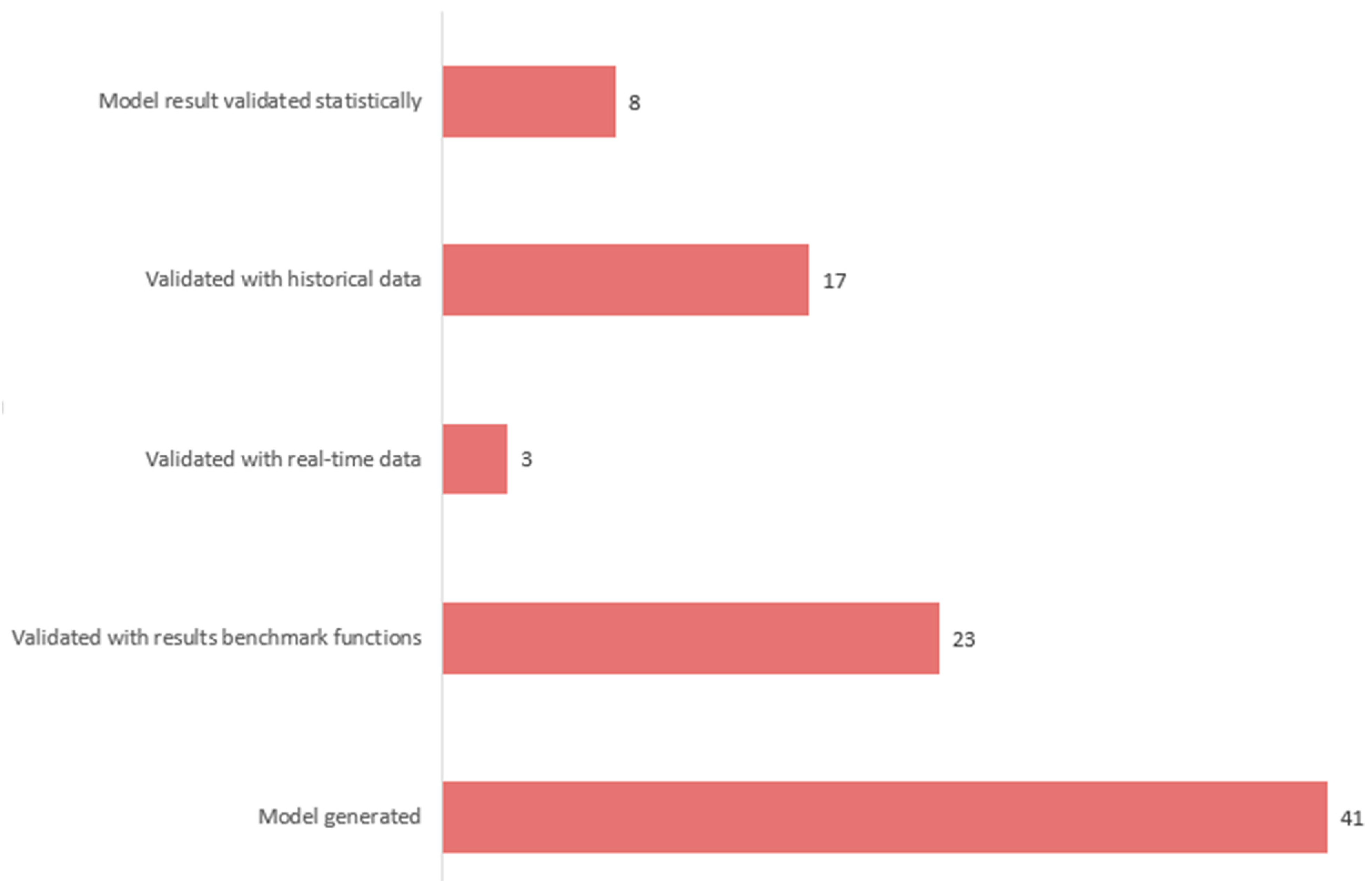
Model generated dataThis is when a model is used to generate data. The model validation approach includes results validation with benchmark functions, results validated with real-time data, results validated with historical data, or results validated statistically.
5.MethodExpert knowledge Experts rank existing EWSs, including the cloud-based EWS, based on their potential to provide warning services to human beings.
Underlining computational algorithmIndicates the computational algorithm interlinking the complex processes of EWSs, namely risk knowledge gathering, monitoring and prediction, communication or dissemination of warning information, and response mechanisms.
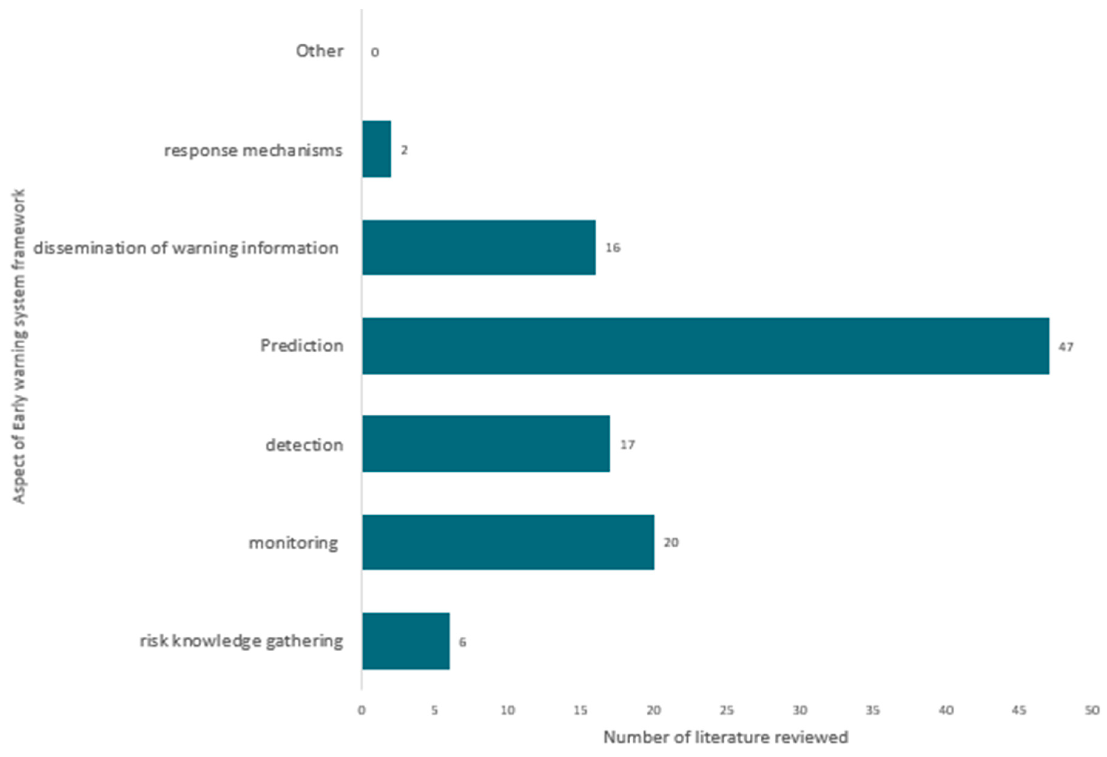
6.Fundamental tenet of early warning systems assessmentRisk knowledge gathering, detection, prediction, dissemination of warning information, and response mechanismsExpresses the components of the early warning systems, which are categorised into five types. EWSs that address more than one tenet are regarded as having a multi-dimensional approach to EWS design.
7.The type of EWSs assessedDifferent kinds of EWSs in literature At least one EWS type should be assessed: flood, drought, earthquake, heat wave, etc.
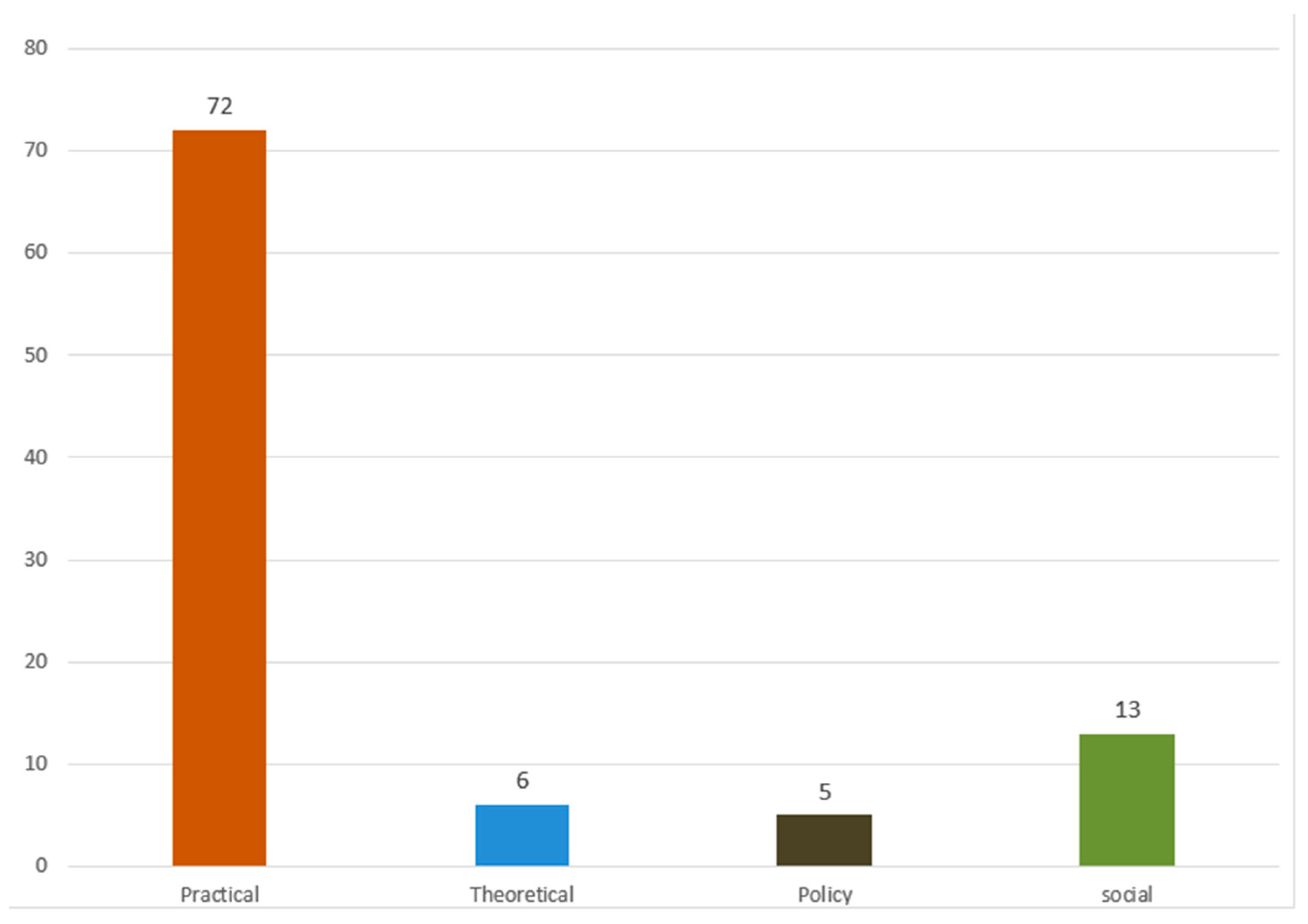
8.Relevant contributionPolicyDescribe the relevant contribution of the reviewed article to policy.
Practical Describe whether the reviewed article has practical relevance.
TheoreticalDescribe whether the reviewed article contributes toward improving theory.
SocialDescribe whether the reviewed article contributes toward improving the societal response to early warnings.
9.LimitationsMethodologicalUncertainties about the result due to the application of the unclear or less developed method.
DataPrimary and secondary data source quality and scarcity that challenge the research work.
Model validationEWS studies that lacks the ability to verify the results using model validation.
Table 6. Articles that met inclusion criteria but were excluded.
AuthorsTopicYear
Cavallin, Sterlacchini [61] GIS techniques and decision support system to reduce landslide risk: the case study of Corvara in Badia, Northern Italy.2011
Cheneau and Risser [62]Real-time mapping and pre-alert system for landslides in the Swiss Alps: the OLPAC methodology.2019
Ghamghami, Ghahreman [63]Detection of climate change effects on meteorological droughts in the Northwest of Iran.2014
Alemaw [64]Flood hazard forecasting and geospatial determinants of hydromorphology in the Limpopo basin, R Southern Africa.2010
Meng, Feng [7] Research on the application of Internet of Things technology in earthquake prevention and disaster reduction2014
Table 7. The EWS framework is divided into cloud and non-cloud components.
AuthorsYearRisk Knowledge GatheringMonitoring DetectionPredictionDissemination of Warning Information Response MechanismsNon-CloudCloudEWS
Yao, Zeng [31]2015 x x x Landslide
Singer, Schuhbäck [65]2009 x x x Landslide
Kuyuk, Allen [66]2014 x x x Earthquake
Hsu and Pratomo [67]2022 xx x Earthquake
Crowell, Schmidt [68]2016 x x x Earthquake
Wald [69]2020 xxx Earthquake
Böse, Wenzel [70]2008 xx x Earthquake
Wannachai, Aramkul [28]2022 x x x Flash droughts
Ritter, Berenguer [71]2020 x x x Flash droughts
Watanabe, Koyama [72]2021 x x x Forest
Harjupa, Abdillah [73]2022 xx x Rainfall
Mahomed, Clulow [74]2021 x x x Lightning
Hofmann and Schüttrumpf [75]2020 xx x Pluvial flood
Uwayisenga, Mduma [76]2021 x x xFlood
Tzouvaras, Danezis [77]2020 xx x Landslide
Wächter, Babeyko [78]2012 x x x Tsunami
Disclaimer/Publisher’s Note: The statements, opinions and data contained in all publications are solely those of the individual author(s) and contributor(s) and not of MDPI and/or the editor(s). MDPI and/or the editor(s) disclaim responsibility for any injury to people or property resulting from any ideas, methods, instructions or products referred to in the content.

