Article

Entropy Change of Historical and Cultural Heritage in Traditional Tibetan Area of China Based on Spatial-Temporal Distribution Pattern

Department of Urban Planning, School of Architecture, Tianjin University, Tianjin 300072, China
*
Author to whom correspondence should be addressed.
These authors contributed equally to this work.
Buildings 2023, 13(12), 2995; https://doi.org/10.3390/buildings13122995
Submission received: 4 September 2023 / Revised: 13 November 2023 / Accepted: 28 November 2023 / Published: 30 November 2023
(This article belongs to the Special Issue Advanced Studies in Urban and Regional Planning)

Abstract

:
The traditional Tibetan area of China is an ethnically and culturally significant region with a historical geographical connection. This study investigates the spatial-temporal distribution patterns and entropy changes of historical and cultural heritage by examining the association between cultural heritage and socio-historical factors. It utilizes analytical methods such as information entropy and incorporates temporal, spatial, and typological information from the data obtained in the Third National Cultural Relics Census. The findings are as follows: (1) The three major regions in the Tibetan area of China alternately serve as development cores for the traditional Tibetan area, exhibiting a fluctuating “dispersion-aggregation” trend of historical and cultural heritage, which also displays notable regional variations. (2) The quantity and entropy change of historical and cultural heritage exhibit correlations between different periods, but there are also some intergenerational differences. (3) The spatial-temporal distribution pattern of historical and cultural heritage demonstrates an inter-era correlation, indicating that socio-historical development is a nonlinear process characterized by both “transition” and “accumulation”. These findings are of significant importance for further understanding the social evolutionary process of human settlements in high-altitude areas and for the comprehensive protection of cultural heritage in ethnic regions.

1. Introduction

Since 2017, China has launched the Second Comprehensive Scientific Expedition to the Qinghai-Tibet Plateau (Qinghai-Tibet Scientific Expedition), which focuses on the human activity history and its impact on the Qinghai-Tibet Plateau. China has a civilization history of over two thousand years. Through long-term interaction and exchange among different ethnic groups, a diverse and unified Chinese civilization has been formed [1]. As an important ethnic region within the Chinese civilization framework, the traditional Tibetan area has produced a precious and unique historical and cultural heritage. Discussing the historical and cultural heritage of the traditional Tibetan area helps us better understand the movement and changes of human cultural activities in the plateau region throughout the history of Chinese civilization. It also provides valuable clues for the Qinghai-Tibet Scientific Expedition and cultural relics census.
In November 2023, the State Council of China issued a notice on conducting the Fourth National Cultural Relics Census, signaling the upcoming launch of a new round of historical and cultural heritage survey nationwide. According to incomplete statistics, China currently has 760,000 historical and cultural heritage sites, which not only include material remains such as ancient sites, buildings, and tombs, but also encompass natural resources with cultural significance, cultural landscapes involving human–nature interaction, and cultural exchange [2]. In 1984, the United States established its first national heritage area, considering interconnected historical and cultural heritage as special linear cultural landscape resources [3]. In recent years, cross-regional historical and cultural heritage resources such as canal waterways [4], railway roads [5], and commercial and cultural routes [6] have received widespread attention from academia.
Analyzing the spatial distribution patterns and formation processes of historical and cultural heritage has become an important scientific topic for reshaping regional civilization processes and strengthening local identity, as it allows for an exploration of the history of regional development and evolution. Historical and cultural heritage (HCH) is the explicit expression of national memory and cultural identity. It records the cumulated social history of spatial resource allocation and reflects social interactions and cultural transmission between nations or regions during certain historical periods [7]. The formation and evolution of historical and cultural heritage are influenced by various factors such as natural climate, geographical conditions, political orientation, and socio-economic factors. There is no consensus on how these factors in history influence historical and cultural heritage.
It can be inferred that social events and processes, cultural diffusion and dissemination, and other information are recorded to varying degrees in historical and cultural heritage. The political, economic, and cultural changes in different historical periods will have an impact on the distribution of heritage. Cultural heritage from different historical periods in the same region will overlap, merge, and transform, forming a new and organic landscape system and spatial order [8]. Although most cultural heritage in a region is expressed in point form, within the framework of territorial spatial planning, the spatial distribution pattern of historical and cultural heritage can be seen as a complex structural entity that involves social processes, cultural stratification, landscape systems, and human–land relationships [9].
Through literature review, we can find that there has been more attention given to the large-scale patterns of historical and cultural heritage [10,11] and cultural heritage routes [12], while there has been less discussion on the distribution of historical and cultural heritage in special regional areas such as ethnic regions, high-altitude areas, and cross-basin areas. Although the geographical characteristics of the integrity [13], systematicity [14], regionality [15], and scalability [16] of historical and cultural heritage have been widely recognized, there has been relatively limited research on the complexity [17], temporality [18], and multiplicativity of historical and cultural heritage. Although some studies have discussed the potential threats and interferences faced by current historical and cultural heritage [19], the impact mechanisms of past geographic factors on the current distribution patterns of historical and cultural heritage still need further investigation and verification [20,21]. Some studies have discussed the distribution patterns of cultural heritage of different periods and types, but little is known about the reasons for changes in the distribution patterns of cultural heritage [22].
Some scholars use time series models to analyze the advantages and changes in the declaration of world cultural heritage in different regions and periods, and assess the impact of heritage strategies on the number of heritage sites included in each region [23]. This interprets the spatial-temporal distribution patterns of historical and cultural heritage as guided by policies, excluding geographical factors. Some scholars have explained the social and historical role of cultural heritage and argue that cultural heritage is primarily a product of economic and social development [24], as well as the dissemination of religion [25], rather than a result of natural geography [23,26,27]. Therefore, the spatial-temporal distribution patterns of historical and cultural heritage should not be regarded as a simple system of geographical factors, but as a geographical phenomenon that can reflect the historical processes of regional societal development and human–environment relationships. It is necessary to consider cultural heritage as the richness of regional social culture [28] and judge the historical processes of regional society based on the complex distribution patterns of cultural heritage [29].
The study of China’s historical and cultural heritage has shifted from a simple case to the study of the coupling between nature and humanity, the relationship between time-space and environment, and the social influence. Scholars have discussed the spatial distribution [30], temporal distribution [31,32], and cultural connotation [33] of historical and cultural heritage in different spatial scopes such as the world [34,35], regions [36,37], river basins [38], and cities [39], and have analyzed the influences of regional geography, national politics, ethnic differences, and other factors on the spatial-temporal distribution pattern of historical and cultural heritage [40,41].
Research on historical and cultural heritage in ethnic regions often concentrates on urban morphology patterns [42,43], ethnic culture [44], religious governance [45], and phenomenon analysis of cultural landscapes [46,47]. The research scope is mostly at the town level or within provinces in areas where ethnic minorities are concentrated, with less study on the spatial distribution and evolution of historical and cultural heritage across administrative boundaries in regions where ethnic minorities live [48]. Analyzing the spatiotemporal distribution characteristics and network structure relationships of historical and cultural heritage can promote human understanding of social changes, cultural succession, and the evolution of human–land relationships [49,50].
The majority of traditional Tibetan areas in China are located on the Qinghai-Tibet Plateau, which is the highest-elevated ethnic region in the world. Despite the analysis of the Prehistoric era in high-altitude areas through geological exploration [51], genetic testing [52,53], ecological footprint [54], and humanity relics [55], our understanding of human activities and social processes on the Qinghai-Tibet Plateau remains very limited [56,57,58,59]. Despite the evidence of human activities in the traditional Tibetan area dating back millions of years [60], including highly mobile, long-distance, and large-scale migration in the early human activities [61], our understanding of human activities and social processes in the traditional Tibetan area during the medieval period on the Qinghai-Tibet Plateau remains limited [62,63,64].
The continuity and development of Tibetan history and culture have been a topic of wide international interest, often criticized for marginalization or cultural extinction of Tibet due to various reasons [65,66]. Discussing the historical and cultural heritage of the traditional Tibetan area from a cultural perspective and incorporating it into the scope of anthropological research by utilizing temporal [67], spatial [68], and typological [69] information stored in the historical and cultural heritage can contribute to a better understanding of cultural exchange trends and spatial evolution mechanisms in high-altitude human settlements. It can also provide strong evidence that the traditional Tibetan area has been an integral part of China since ancient times and, more importantly, help better understand the close connection between the traditional Tibetan area and the central government in history, thereby reshaping the historical narrative discourse of the traditional Tibetan area [70].
In response to the issues of geographical determinism and causal inversion in the current research on the spatial and temporal distribution patterns of cultural heritage, the concept of the complexity of historical and cultural heritage is proposed [71,72]. It discusses the differences and connections between different types and periods of cultural heritage, with time as a potential driving force, forming a formative analytical framework to examine the diversity of historical and cultural heritage. By observing the changes in the diversity of historical and cultural heritage, the phenomenon of cultural exchange, dissemination, and integration that occurred in different historical periods within a region can be discussed [73,74]. Most historical and cultural heritage consists of inherited ancient buildings and structures. Discussing the diversity of historical and cultural heritage helps to bring cultural heritage research into the perspective of anthropology and regional history, which is of great significance for further understanding the unique historical and cultural processes of high-altitude ethnic regions [75].
Therefore, this study aims to analyze the spatiotemporal distribution patterns of 4367 historical and cultural heritages, revealing their distribution in different regions and time periods. This analysis not only helps us understand the background and evolution of these cultural heritages but also provides important reference for the study of regional history. Additionally, through studying their hierarchical patterns, we can uncover the interconnections and influences among different types of cultural heritages, contributing to a more comprehensive understanding of their value and significance. In this study, we will utilize tools such as information entropy and Pearson correlation for analysis. Information entropy assists in quantifying the complexity and diversity of the spatiotemporal distribution patterns of historical and cultural heritages, thus revealing their regularities and characteristics. Meanwhile, Pearson correlation helps explore the degree of correlation between historical and cultural heritages in different periods, further uncovering their mutual influence and mechanisms.
Through the implementation of this study, we hope to provide scientific basis and decision-making support for the protection and inheritance of historical and cultural heritages in traditional Tibetan areas of China. Additionally, we aim to promote the inheritance and promotion of traditional Chinese culture, enhance people’s sense of identity and pride in historical and cultural heritages, and stimulate the diversified development and prosperity of culture [76].

2. Materials and Methods
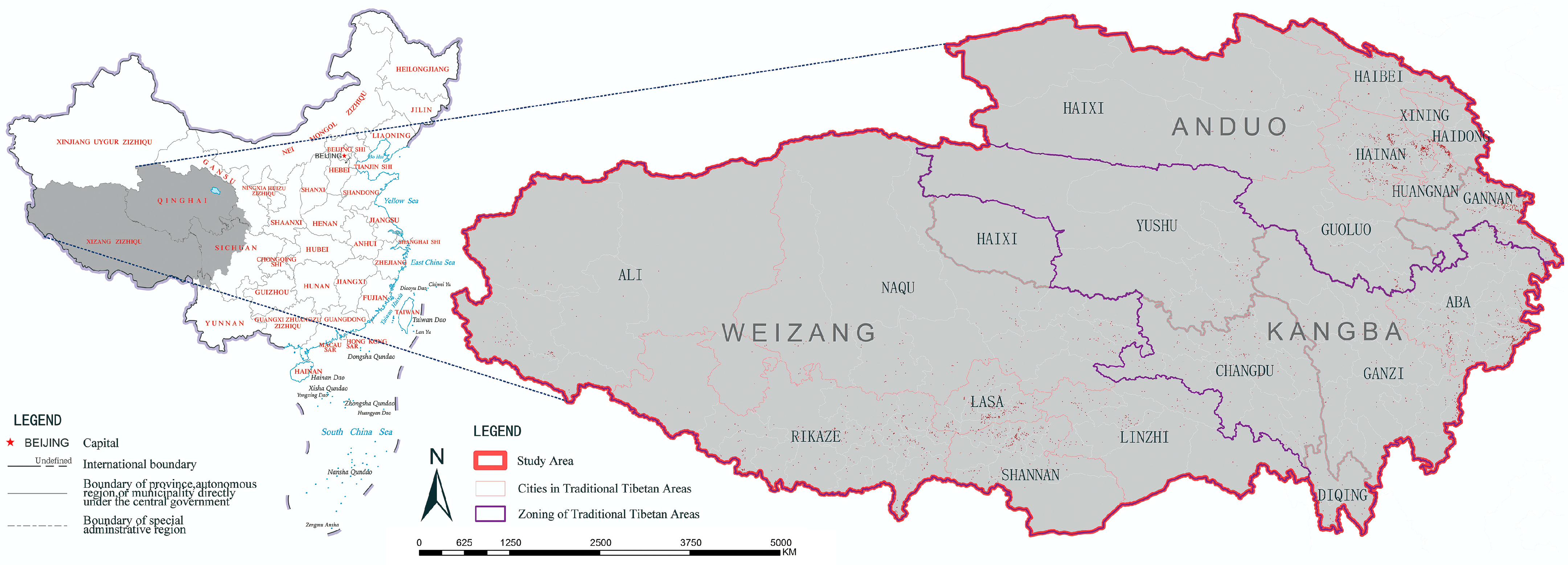
2.1. Study Area

The research area of this study is the traditional Tibetan area (26°51′ N–39°12′ N, 78°23′ E–104°45′ E), with an area of approximately 2,613,819 km2. The traditional Tibetan area in China consists of the regions of Weizang, Anduo, and Kangba, which cover the entire Qinghai and Xizang, as well as parts of Sichuan, Yunnan and Gansu Province. It is an extensive cultural region [77] inhabited mainly by the Tibetan ethnic group, with 19 prefecture-level cities and 161 districts and counties (Figure 1). The traditional Tibetan area is one of the highest-altitude regions in the world, with its steep terrain and complex natural geography nurturing a unique ethnic way of life and religious and social culture than other regions of China.
Since the Yuan Dynasty unified the Tibetan areas and established local governments, the three major Tibetan regions gradually formed. They include the Weizang region (religious domain) primarily in Tibet, the Anduo Tibetan region (pastoral domain) primarily in Qinghai, and the Kangba Tibetan region (human domain) primarily in western Sichuan and eastern Tibet. These three regions are not only dialectal regions in the Tibetan language but also different human and geographical regions. The Tibetan proverb says, “Weizang people are religious, Kangba people are warriors, and Anduo people are good at business”. This reflects the basic understanding of the characteristics of the three major regions by Tibetans. The traditional Tibetan area has a large number and diverse types of historical and cultural heritage. For the purpose of convenience and understanding, this study uses the modern Chinese Pinyin system for place names. Terms such as Weizang (Ü-Tsang), Kangba (Kham), Anduo (Amdo), Rikaze (Shigatse), Changdu (Chamdo), and Lasa (Lhasa) are not written using the traditional Tibetan phonetic system.

2.2. Methods

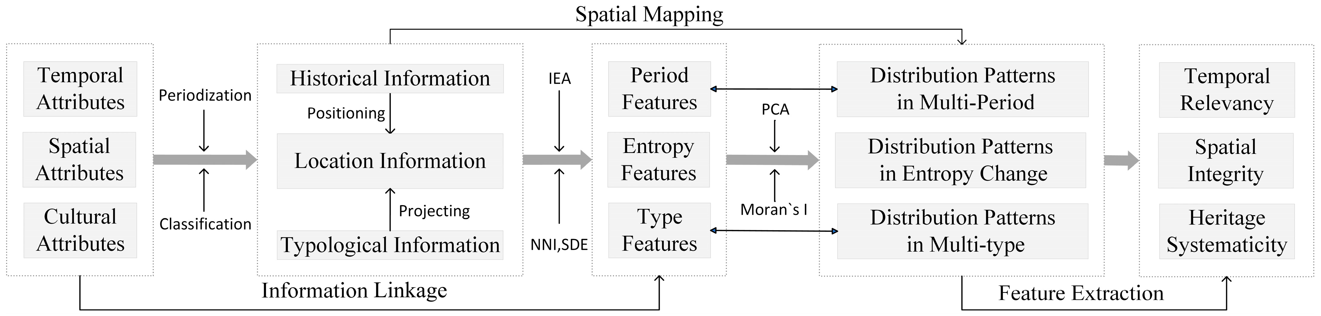
2.2.1. Research Approach

The spatial-temporal distribution pattern of historical and cultural heritage refers to the structural distribution state of material remains with cultural functions within a certain time range and a certain geographical range, which is the result of long-term interaction between the natural environment and human activities. We know that the distribution pattern of historical and cultural heritage is the spatial expression of multiple interacting factors. However, the process of change for many of these factors is unclear. Therefore, by suspending other elements, we view the distribution pattern of historical and cultural heritage as a spatial system, hoping to find clues to the changes from the distribution pattern of historical and cultural heritage. By analyzing this spatial system, the complexity of traditional Tibetan historical and cultural heritage and the social-historical processes it reflects can be discussed (Figure 2).
The distribution pattern of historical and cultural heritage is discussed using basic geographic analysis methods. The method of periodization is used to determine the temporal characteristics of cultural heritage, while the method of classification is used to determine the cultural characteristics of cultural heritage. The combination of temporal and typological features is used to discuss the entropy changes in historical and cultural heritage. By transforming the features of three dimensions into the distribution pattern of historical and cultural heritage, the temporal correlation, spatial integrity, and heritage system of traditional Tibetan historical and cultural heritage can be summarized. Analyzing cumulative temporal changes and entropy rules of historical and cultural heritage is of great significance for scientifically grasping regional development trends and optimizing the pattern of historical and cultural heritage.

2.2.2. Information Entropy Algorithm (IEA)

With technological advancements, new theories and technologies, including social spatial computing, cultural geospatial analysis, complex systems networks, and others, are gradually being introduced into the study of historical and cultural heritage. Methods such as exploratory spatial analysis have gradually been applied to the study of historical and cultural heritage [78,79,80], providing new possibilities for exploring the distribution patterns of historical and cultural heritage [81].
The spatial-temporal distribution patterns of historical and cultural heritage were gradually formed in ancient societal development and evolution. Although some studies have explored the conditions of the spatial-temporal distribution patterns of historical and cultural heritage using contemporary geographic data, such as construction [82], transportation [83], hydrology [30], and climate [84], and argue that these conditions have an impact on the distribution patterns of cultural heritage, the causal relationship between historical and cultural heritage and other geographic factors is still not clear [85,86], and often falls into the trap of geographical determinism.
The current mainstream methods of multi-factor exploration in academic research often result in logical problems of causal inference inversion, leading to temporal contradictions. Therefore, information entropy is used as the main technical method to describe the complexity changes in the distribution patterns of historical and cultural heritage. Within a certain period of time and spatial range, the more numerous and diverse the quantity and types of historical and cultural heritage, the more complex we consider them to be.
Information entropy is an index used to describe the degree of confusion of things. The distribution of historical and cultural heritage in the region presents local characteristics that change with time series, and this characteristic is composed of structure and randomness. In order to measure and predict historical and cultural heritage, Shannon’s information entropy theory is used to perform information entropy calculation of historical and cultural space in different time phases.
H x P x i i = 1 n log 2 P x i   ( P x i = k i N   i   =   1 ,   2 ,   ,   N )
where H x is the information entropy of historical and cultural heritage, P x i is the probability value of each type of cultural heritage, k i is the frequency of a certain type of cultural heritage, and N is the total amount of cultural heritage. The calculation based solely on chronological and typological information may have theoretical shortcomings in terms of geographic factors and explanatory power of phenomena. However, it can still serve as a quantitative method to study the history of human societies within a specific region.

2.2.3. Basic Geographical Analysis

This paper analyzes the spatial information characteristics of historical and cultural heritage using the nearest neighbor index (NNI) and standard deviation ellipse (SDE) (Table 1). The diversity and complexity of the distribution of historical and cultural heritage are studied using the information entropy algorithm. Spatial Autocorrelation Analysis (Moran’s I Index) and Pearson’s Correlation Analysis (PCA) are applied to explore the interrelationships among historical and cultural heritage, providing a quantitative analysis of regional social-historical changes. This offers new insights into the complexity and diversity characteristics of historical and cultural spatial distribution.

2.3. Materials

This research is based on the cultural heritage resource list publicly released by national ministries and local governments, including the cultural heritage protection units (919 sites) and general cultural heritage sites (3448 sites) announced by cities, counties, and districts during the Third National Cultural Relic Census. The administrative division data are sourced from the Resource and Environmental Data Cloud Platform of the Chinese Academy of Sciences (http://www.resdc.cn/, accessed on 15 July 2023).
Based on the cultural heritage resources (Table 2), this study verifies the spatial location of cultural heritage by referencing local chronicles, cultural yearbooks, cultural relic bulletins, and government department files, and forms a cultural heritage database containing construction information, which is categorized by type and period. For cross-regional cultural heritage, multiple key areas are selected for placement. The cultural heritage data used in this study may have some duplication, such as some national key cultural heritage protection units including general heritage sites. The original lists are retained without deletion.

3. Results

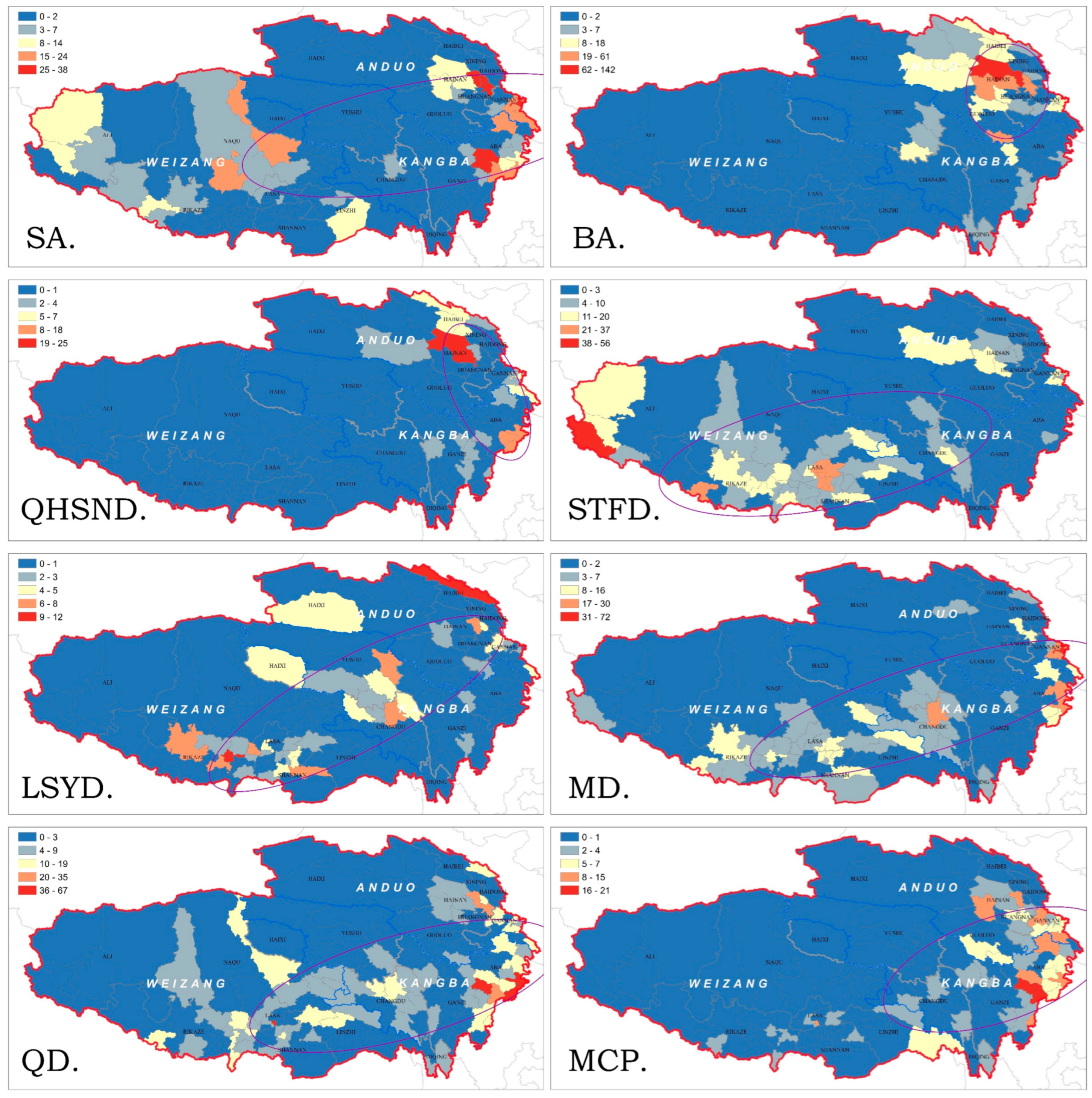
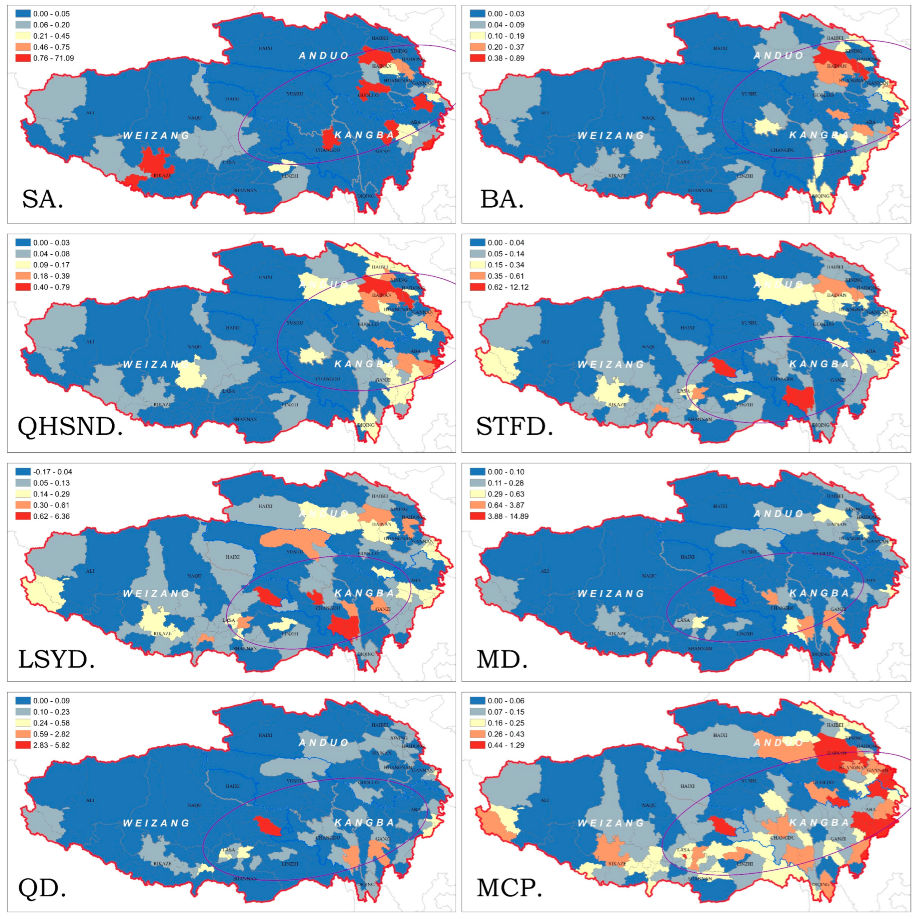
3.1. The Distribution Pattern of Historical Cultural Heritage in Multiple Periods

3.1.1. Distribution Characteristics of Historical and Cultural Heritage in Multiple Periods

According to the principle of relative balance, the historical and cultural heritage of the traditional Tibetan region can be divided into eight periods (Table 3). The historical cultural heritage in the traditional Tibetan areas of China has to some extent preserved the process of civilization competition and cultural integration. The historical cultural heritage of the traditional Tibetan areas in China shows a significant trend of concentration in chronological order (Figure 2).
By calculating the nearest neighbor index (NNI) for cultural heritage from different periods, it can be observed that the traditional Tibetan cultural heritage in China exhibits significant clustering characteristics. Cultural heritage from the Stone Age shows the highest level of clustering, with an NNI of 0.265, while the cultural heritage from the Qin-Han and Southern and Northern Dynasties is relatively dispersed, with an NNI of 0.451. Although the quantity of cultural heritage from the Ming Dynasty is similar to that of the Stone Age, the cultural heritage from the Ming Dynasty is more dispersed. Under the assumption of relatively stable natural conditions, it is evident that human activities during the Ming Dynasty were more extensive, indicating that the socio-economic aspects of the Ming Dynasty were more adaptable and resilient to the natural geographic environment. The number of cultural heritages from the Bronze Age is similar to the number of cultural heritages from the Qing Dynasty, while the distribution of cultural heritages from the Bronze Age is more concentrated, with an NNI of 0.272. The number of cultural heritages from the Qin-Han and Southern and Northern Dynasties is similar to the number of cultural heritages from the Liao, Song, and Yuan dynasties, but the cultural heritage sites from the Qin-Han and Southern and Northern Dynasties are more dispersed, with an NNI of 0.451.

3.1.2. Distribution Pattern of Historical and Cultural Heritage in Multiple Periods

Overall, the distribution and aggregation characteristics of historical and cultural heritage in the traditional Tibetan areas have been continuously significant. With the passage of time, the core of heritage aggregation has shifted among the three major Tibetan areas and become stable (Figure 3). From the perspective of the distribution of cultural heritage, there is a trend of aggregation from west to east, which is particularly evident during the Bronze Age and the Qin-Han and Southern and Northern Dynasties.
The Stone Age historical and cultural heritage was concentrated in the eastern edge of the plateau and the surrounding area of the Yellow River basin, showing an overall uneven distribution pattern with denser distribution in the east and sporadic distribution in the west. This period was influenced by the altitude and natural environment, with the regions of the Gangdisi Mountains and the Hengduan Mountains being unsuitable for human activities, resulting in very few scattered cultural heritages. During the Bronze Age, historical and cultural heritage in the traditional Tibetan region gathered and appeared to have a trend of polarization in the Huangshui River basin and the foothills of the Laji Mountain due to the migration of Central Plains immigrants and the construction of military fortresses. During the Bronze Age to the Qin-Han and Southern and Northern Dynasties, the cultural heritage primarily gathered in the eastern part of the traditional Tibetan areas.
During the Qin, Han, and Southern and Northern Dynasties, as the central control area extended westward, the long-term confrontation between the Central Plains and the local areas led to a sharp decline in the population of ethnic minority groups such as the Wuhuan, Xiongnu, and Western Qiang. As a result, the cultural heritage also decreased. Government immigration and natural migration prompted population movement southward. At this time, the historical and cultural heritage in the traditional Tibetan areas showed a dual-core distribution pattern of Anduo and Kangba. Starting from the Sui and Tang Dynasties, cultural heritage gradually converged, showing a trend of moving closer to the east. The rise of the Tubo Dynasty prompted a spatial migration of the distribution center of historical and cultural heritage from east to west. The Anduo region experienced a peak of aggregation, while the Anduo and Kangba regions fell into a trough. At the same time, the economic and trade exchanges between Tubo and the central dynasties and the “Musk Route” also promoted the socio-cultural development of regions along the route such as Aba and Changdu, as well as the Ali region.
After the fall of the Tubo Dynasty (equivalent to STFD.), conflicts among various traditional tribes in the Tibetan region intensified, weakening the population and economic advantages in the Lhasa area. Branches of the Tubo tribe established their regimes in the Huanhe River basin in Qinghai Province, centered around Haidong (Ancient Miaochuan) and Xining (Ancient Qingtang), while Qiang tribes re-engaged in independent activities in the Yushu area after the fall of the Tubo Dynasty, leading to a significant increase in the quantity and density of cultural heritage in the Anduo and Kangba regions during the Liao, Song, and Yuan Dynasties. In the Ming Dynasty, inheriting the Tusi policy from the Yuan Dynasty, the distribution center shifted towards the eastern border of the Tibetan region, with no significant changes in the distribution range. Since the Qing Dynasty, with the continuous integration of the traditional Tibetan region and the mainland in politics, economy, and culture, the pattern of cultural heritage has shown a continuous movement of the center of gravity towards the Aba and Gannan regions, which are at the junction of the Han and Tibetan cultures, exhibiting characteristics of polarization.
Generally, the closer the heritage is to the present day, the higher the probability of its preservation. The longer the time span, the greater the number of preserved historical and cultural heritages. In terms of spatial distribution, the quantity and clustering degree of historical and cultural heritage in each period show fluctuating changes (Figure 4). Among them, four clusters of historical and cultural heritage have been formed from the Paleolithic Age to the Qin, Han, and Northern and Southern Dynasties periods, exhibiting the distribution characteristics of HH clusters against LL clusters. Among them, HH clusters and LH clusters are distributed alternately in the northeastern part of the traditional Tibetan region, while LL clusters are mainly distributed in the central and southern parts of the traditional Tibetan region, accompanied by a small number of LH clusters. The distribution ranges of each cluster expand with the passage of time. Since the Sui, Tang and Five Dynasties period, there have been obvious abrupt changes in the clustering distribution of the traditional Tibetan region.
HH clusters are distributed in the southern part of Changdu region and gradually shrink and disappear from the Sui, Tang to Qing Dynasties. LL clusters are mainly distributed in the central and northern parts of Kangba and the southern part of Anduo, with LH clusters showing a clear trend of migration along the Tanggula Mountains from southeast to northwest. In the Qing Dynasty and modern times, the clustering distribution characteristics are similar to those of the Paleolithic Age to the Qin, Han, and Northern and Southern Dynasties periods. The distribution areas of HH and LH clusters overlap more, and the clustering tendency continues to increase, reflecting the intermittent distribution pattern of LL clusters in a northeast-southwest direction in places like Rikaze, Naqu, and Haixi due to the accelerated process of modernization and Sinicization in this region.

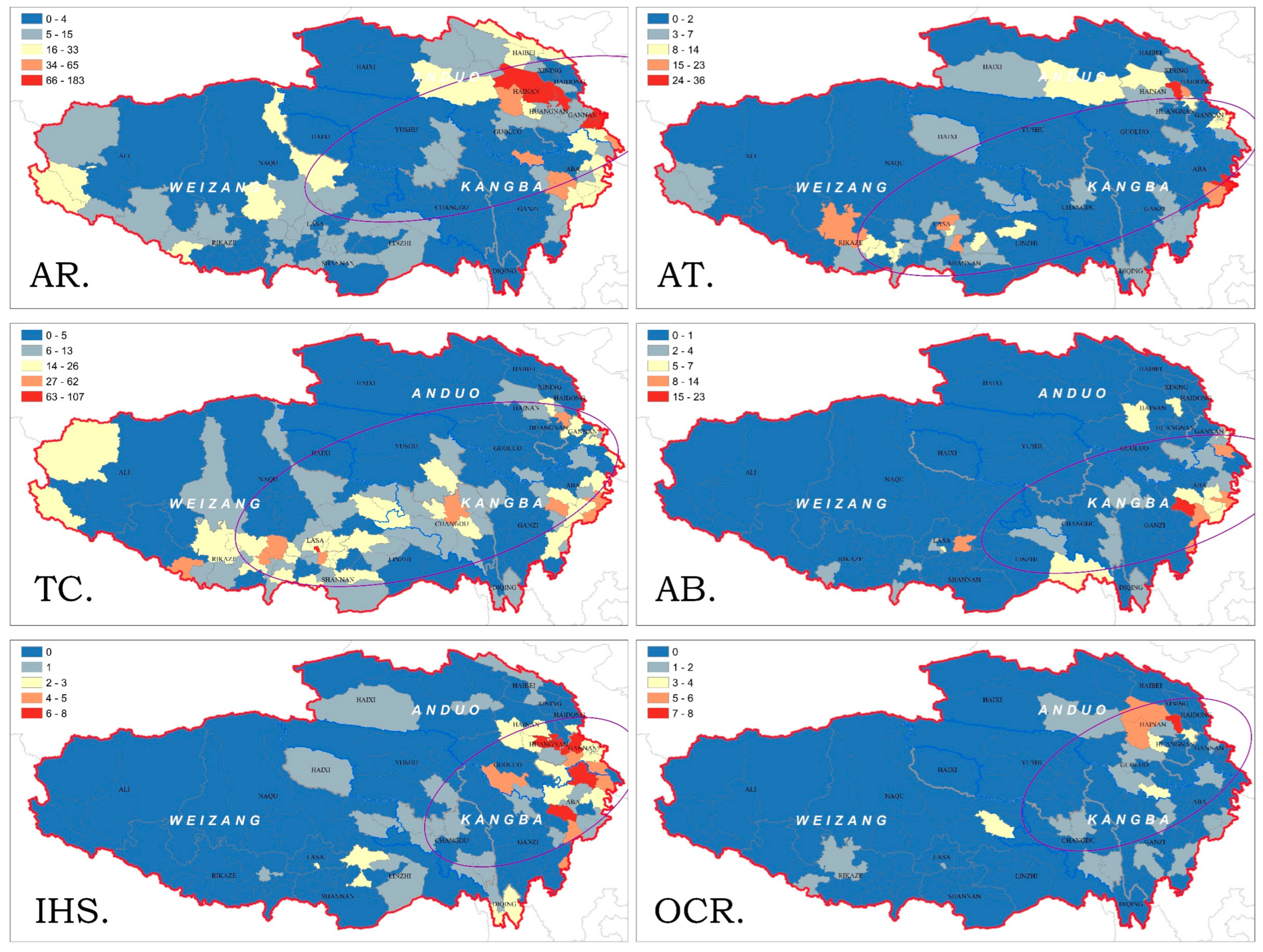
3.2. The Distribution Pattern of Multi-type Historical and Cultural Heritage

3.2.1. Distribution Characteristics of Multi-Type Historical and Cultural Heritage

The coverage of historical and cultural heritage in the traditional Tibetan areas is extensive, showing significant regional differences in types. According to the attributes of cultural heritage, it can be divided into six types, including the ancient ruins, the ancient tombs, temples and carvings, the ancient buildings, the Important Historical Sites from the Modern period, and other cultural relics (Table 4).
The quantity of ancient ruins is the highest, and their aggregation is also the most pronounced. The ancient ruins mainly include temple ruins, ancient city ruins, and military fortress ruins. These ancient ruins were abandoned in the course of history, and their high level of aggregation indicates the transition from more concentrated settlements to a broader geographic dispersion in ancient societies. The ancient tombs are generally found in burial clusters and have a strong spatial correlation with human settlements of different eras. Although the aggregation of ancient tombs is second only to ancient sites, their quantity is only one-third of that of ancient sites. The relatively high aggregation of ancient tombs provides a possibility for understanding human social behavior on the Qinghai-Tibet Plateau, suggesting a gradual transition from settlements in areas with better geographical and climatic conditions, such as valleys, to areas with poorer conditions, resulting in a shift from a concentrated pattern to a dispersed one. Temples and caves have slightly fewer numbers compared to ancient sites, and they are also more dispersed. Some temples after the Sui and Tang Dynasties were metaphorically referred to as “joints that suppress witches” in Tibetan legends. The dispersed pattern of temples and caves echoes this concept in the legends.

3.2.2. Distribution Pattern of Multi-Type Historical and Cultural Heritage

Overall, the historical and cultural heritage in the traditional Tibetan areas exhibits significant regional, temporal, and multi-polarization characteristics (Figure 5). High-density distribution areas are located at the intersection of the Anduo region and the eastern part of the Kangba region, while low-density distribution of historical and cultural heritage is found in the Changdu, Ganzi, and Yushu where the Hengduan Mountains are located. The distribution of ancient ruins, which mainly consist of early civilization settlements and town ruins, is influenced by the terrain factors of the interlacing between high mountains and valleys. They are densely distributed in the eastern Tibetan areas, such as the Hehuang Valley and Songpan Grassland, which have lower altitudes and are suitable for agriculture [87].
The ancient tombs are widely distributed in areas with dense population and cultural phenomena, and they highly overlap with the active range of the Tubo Dynasty. They form three core areas in Lasa of the Weizang region, Aba of the Kangba region, and Hainan, Huangnan of the Anduo region. The grotto temples and stone carvings are mainly distributed along the ancient Buddhist propagation route called “Tangfanni”, forming a belt-shaped distribution. The main cores are in Lasa and Shannan, with multiple concentrations in places like Rikaze, Changdu, Aba, and Huangnan. With the rise of transportation methods such as Maritime Silk Road, there are rarely newly built grotto temples and stone carvings in the Tibetan areas.
Compared to other types of historical and cultural heritage, the number of ancient buildings is relatively small. They are concentrated in the relatively flat areas with a larger number of towns, such as the Aba region, and the secondary concentrated areas are in regions with relatively developed industry and commerce, such as Lasa, Xining, and Gannan. The Important Historical Sites from the Modern period mainly include battle memorial sites, administrative office sites, and industrial and commercial production sites. Therefore, they are concentrated in the eastern edge of the Tibetan areas where transportation conditions are better and resource development started earlier. Gannan, as an important node for the Red Army’s Long March and the major defeat of the Nationalist Army, has a relatively large number of important modern and contemporary historical sites.
Different types of cultural activities and behaviors have shaped the diverse distribution patterns of historical and cultural heritage (Figure 6). The ancient ruins, the important Historical Sites from the Modern periods, and other cultural relics have similar distribution patterns. Natural conditions such as topography and terrain influence the clustering types of these types of historical and cultural heritage through their impact on human activities. HH clustering and LH clustering are widely distributed in the northeastern part of the traditional Tibetan area, indicating that the northeastern part is an important area where frequent production and living activities of traditional Tibetans occur. LL clustering is mainly distributed in the central and southern plateau regions, such as Rikaze and other areas with high mountains and deep valleys and higher utilization requirements, indicating that the production of historical and cultural heritage in the early stages of different development stages of agricultural activities and industrialization is limited by technological levels.
The clustering distribution of ancient buildings is more balanced. HH clustering is distributed in the eastern part of the traditional Tibetan area, which is also the region with the most favorable conditions in terms of topography, terrain, and transportation accessibility. The construction difficulty is relatively small, and the distribution of ancient buildings is more prominent in terms of quantity. The clustering of ancient tombs, grotto temples, and stone carvings is accompanied by HH clustering and LH clustering, mainly distributed in two major regions centered on Lasa and Aba, respectively. The clustering of LL is characterized by significant spatial complementarity.
The LL clustering of ancient tombs is mainly distributed in the Kangba region, while the LL clustering of grotto temples and stone carvings is mainly distributed in the Anduo region. This is closely related to the different functions developed over time in the three major regions of traditional Weizang, Anduo, and Kangba. The Anduo region, also known as the “Land of Horses”, is an area where nomadic culture thrives. It is not primarily influenced by religion, hence there are relatively fewer temples in this region. The temples are densely distributed in areas where religious dissemination is widespread, while the ancient tombs are mainly found near settlements that developed in different periods. It can be inferred that the distribution patterns of different types of cultural heritage can reflect the cultural characteristics of a region.

3.3. The Distribution Pattern of Entropy Change in Historical and Cultural Heritage

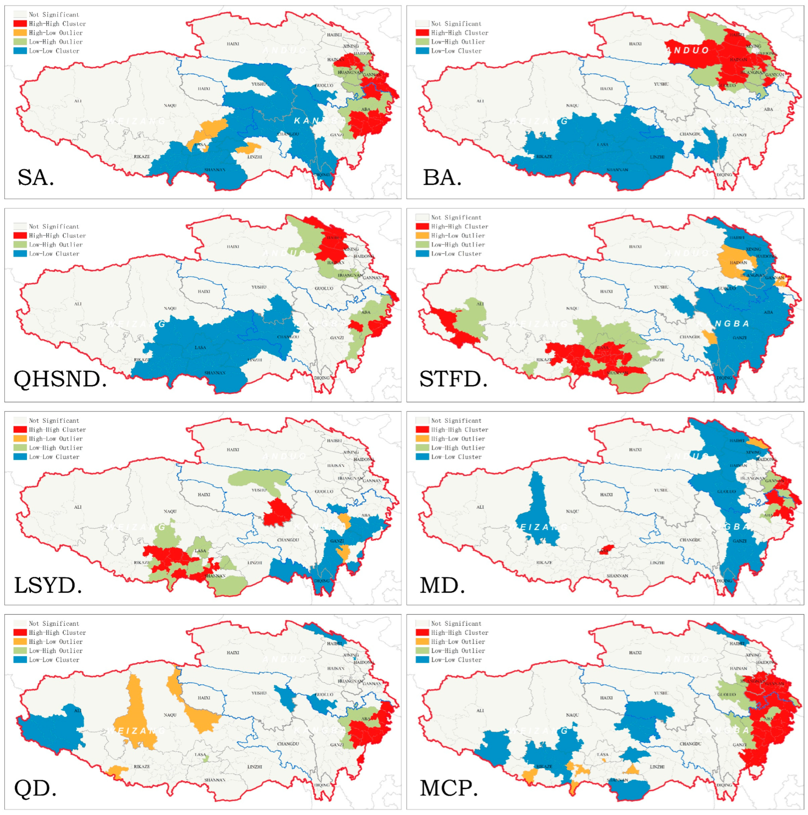
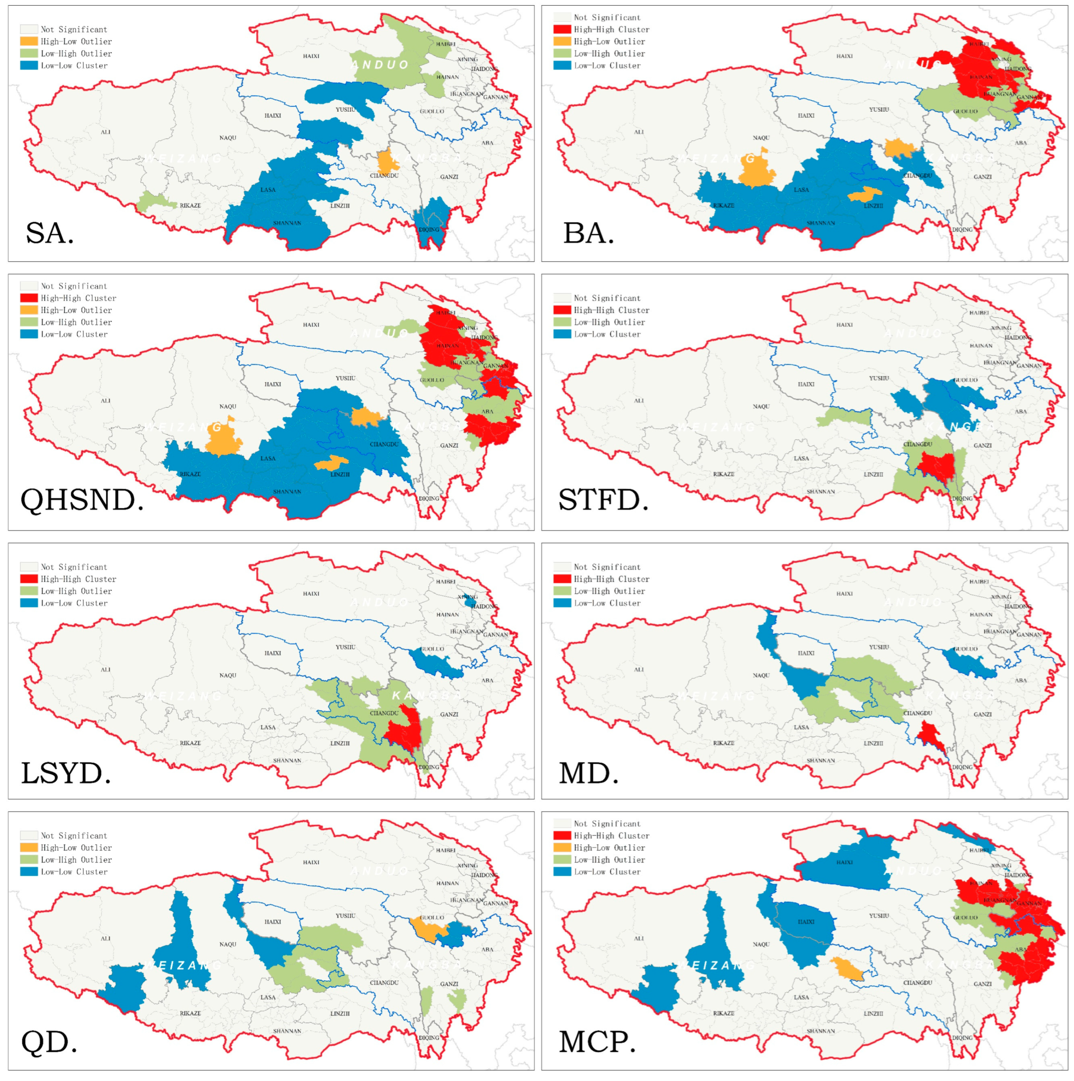
3.3.1. Overall Distribution Pattern of Entropy Changes in Historical and Cultural Heritages

Entropy is a term used in physics to describe the degree of disorder or randomness in a system. In the study of cultural heritage, entropy is used to measure the diversity, complexity, and degree of change of traditional Tibetan cultural heritage in the Tibetan region. Entropy change analysis can provide a scientific basis and reference for the protection and inheritance of traditional Tibetan cultural heritage.
Entropy change analysis compares cultural heritage data from different time periods to calculate the entropy value of the heritage, thus understanding the dynamic process of heritage change. If a region has a greater variety of cultural heritage types and a more even distribution, its entropy value will be higher, indicating a higher level of cultural heritage diversity. Conversely, if the quantity of a certain heritage type decreases or disappears over different time periods, the entropy value will decrease, indicating that the heritage is facing the risk of loss or decline.
The clustering characteristics of entropy change in the traditional Tibetan areas of historical and cultural heritage in China are significant. The core of entropy increase has spread and migrated from the eastern part of Anduo region to the intersection of Weizang region and Kangba region, and then moved to the intersection of Anduo region and Kangba region (Figure 7). There has been no significant high-value aggregation of entropy change in the northern Tibetan Plateau. Prior to the Qin, Han, and Northern and Southern Dynasties, the high-value aggregation area of entropy change in the traditional Tibetan areas of China was mainly distributed in the surrounding areas of Gannan, Huangnan, and Haixi, and the range of high-value increase continuously expanded. The Weizang region centered on Lasa was a low-value aggregation area of entropy change, showing a significant spatial differentiation distribution pattern.
After the Tubo Dynasty (equivalent to STFD.) and the fusion of politics and ethnic groups, the unipolar entropy increase pattern centered around Hainan and Haibei gradually migrated southward, forming a distribution pattern centered around Gannan, Huangnan, and Aba regions. From the Sui, Tang, Five Dynasties to the Qing Dynasty, the areas where Changdu, Yushu, Linzhi, and Naqu are located maintained a long period of high-value aggregation of entropy increase. The high-value aggregation of entropy changes continuously moved northward and gradually showed a decreasing trend in aggregation degree. During this stage, there were no obvious low-value aggregation areas within the traditional Tibetan areas. In modern times, the high-value aggregation of entropy change in the historical and cultural heritage is concentrated in the intersection of Anduo region and Kangba region, where Aba, Gannan, and Guoluo are located, and there are a few low-value aggregation areas in the southeastern part of the Weizang area and the southern part of the Kangba region.

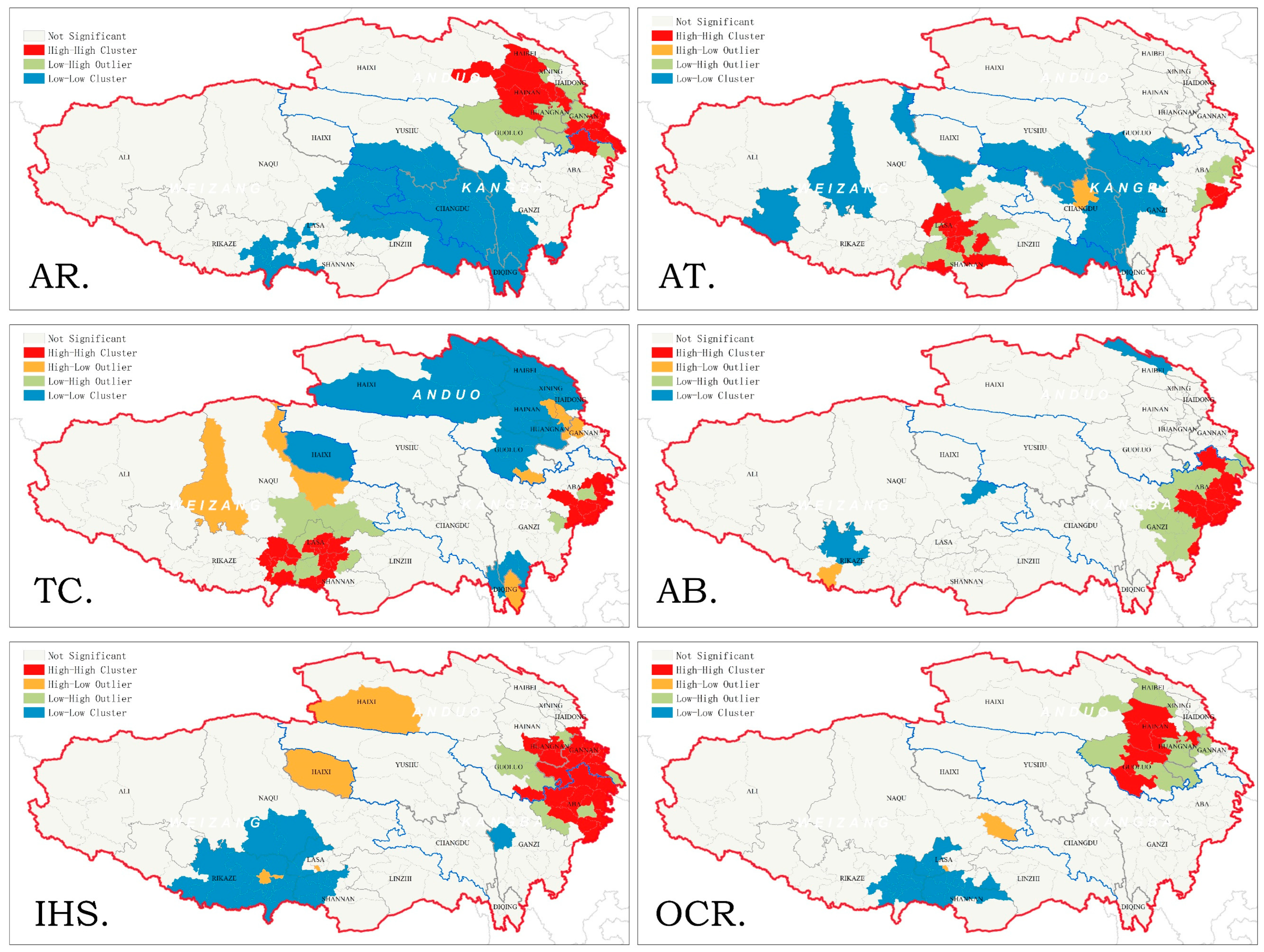
3.3.2. The Autocorrelation Distribution of Entropy Changes in Historical and Cultural Heritage

The types of cultural heritage in the traditional Tibetan areas are gradually increasing and becoming more complex. They exhibit a trend of fluctuating growth and gradual expansion (Figure 8). During the Stone Age, the entropy increase of traditional Tibetan historical and cultural heritage in China was mainly characterized by low-value clustering, with a small amount of LH clustering distributed in the Qaidam Basin, where Haixi, Haibei, and Hainan are located. From the Bronze Age to the Qin, Han, and Northern and Southern Dynasties, the entropy changes of cultural heritage formed four distinct patterns with significant spatial differentiation. Among them, HH and LH clusters were distributed in the monsoon climate-dominated areas where Hainan, Gannan, and Aba are located, while LL clusters and a small amount of HL clusters were distributed in the plateau areas west of the Hengduan Mountains and north of the Himalayas.
The distribution of historical and cultural heritage from the Sui, Tang, Five Dynasties, Liao, Song, and Yuan Dynasties shows a significant leap, forming three clusters, with high-value and low-value clusters mainly distributed in the Kangba and Anduo region. The LH cluster is mainly located in the Changdu area, surrounded by the HH cluster, while a small number of LL clusters are distributed in the Ganzi and Guoluo. By the Ming and Qing Dynasties, the HH cluster disappeared, and the LH cluster moved northward to the border area of Naqu and Yushu, with a few scattered LL clusters appearing in the Weizang region. In modern times, the high-value cluster of historical and cultural heritage returned to the Aba, Gannan, Huangnan, and Hainan regions, while the LL cluster showed a southwest-to-northeast scattered distribution pattern in Rikaze, Naqu, Yushu, Haixi, and Haibei, indicating a shift in social, economic, and cultural activities towards towns intersecting with the mainland.
The increase in entropy of historical and cultural heritage is an indicator that measures the richness and disorder of cultural heritage in spatial distribution during different periods, and it explains the formation principles of the spatial distribution pattern of current historical and cultural heritage.
The distribution pattern of the increase in entropy of historical and cultural heritage, using the type information and age information of cultural heritage, depicts the formation process of social history in traditional Tibetan areas in China. In terms of the types and characteristics of historical and cultural heritage (Figure 9a), ancient sites are most closely associated with the overall distribution pattern of historical and cultural heritage, followed by ancient tombs, other types, temples, and caves. Although the number of other types of cultural heritage is the smallest, they are closely related to the overall distribution of historical and cultural heritage. Modern representative historical sites have the least influence on the overall distribution pattern of historical and cultural heritage. In addition, there is a high correlation between ancient sites and ancient tombs, temples and ancient buildings, and ancient tombs and temples, suggesting that the spatial distribution pattern of historical and cultural heritage is related to the cultural characteristics of human activities in different periods. Modern settlements have a significant spatial differentiation from ancient settlements, and there is also spatial differentiation between continuous ancient settlements and abandoned settlements. Temples play a crucial role in the development and evolution of settlements.
It is generally believed that “the closer the periods are, the stronger the correlation”. Connected periods should have a strong correlation. According to the statistical analysis of the correlation between the distribution of the quantity of historical and cultural heritage in different periods and the distribution of entropy changes, it is found that the spatial distribution pattern of historical and cultural heritage has the dual characteristics of cumulation and transition. In terms of the quantity of historical and cultural heritage (Figure 9b), there is a more significant correlation between the Stone Age and the modern and contemporary, Qing Dynasty, and Ming Dynasty. This indicates that there is a discontinuous “pattern transition” in the long-term cumulation process of historical and cultural heritage. The Qin-Han and Southern and Northern Dynasties and earlier periods show strong correlation, while the Ming, Qing, and contemporary periods show strong correlation, and the values of the two stages of intergenerational superposition are closer.
The multigenerational relevance of the spatial distribution pattern of historical and cultural heritage reflects the social and historical development process of the regional space. In terms of the increase in entropy of historical and cultural heritage (Figure 9c), before the Sui and Tang Dynasties, the increase in entropy of historical and cultural heritage in the traditional Tibetan areas of China basically follows the cumulation characteristics. After the unification of the Tibetan area by the Tubo Dynasty, there is a sudden change in the increase in entropy of historical and cultural heritage, entering the second stage of linear superposition, and there is a significant negative correlation with the previous period in terms of entropy increase. The modern and contemporary period has a strong correlation with the entropy changes in the Sui and Tang Dynasties and earlier periods, reflecting a significant transition.

4. Discussion

The United Nations Educational, Scientific, and Cultural Organization (UNESCO) cultural heritage policies and Chinese state-directed tourism policies have played a significant role in the preservation of historical sites and the development of ethnic culture in contemporary Tibet [88]. This study of the temporal and spatial distribution patterns of historical and cultural heritage in traditional Tibetan can provide valuable support for the ongoing national cultural relics survey and comprehensive scientific expedition on the Qinghai-Tibet Plateau (Qinghai-Tibet Scientific Expedition). By analyzing the temporal and spatial distribution patterns and entropy trends of traditional Tibetan historical and cultural heritage, it is possible to discuss the process of social change in high-altitude regions from a regional perspective.
In recent years, social historical research at the regional level has gradually gained attention from scholars. In recent years, there has been increasing attention to cross-regional historical and cultural heritage resources, and researchers have been devoted to optimizing the allocation of regional cultural resources. The spatial distribution patterns of historical and cultural heritage reflect the structural distribution of cultural functions that have existed over a certain period of time and within a geographical range. In our previous research, we found that non-geographical factors such as politics, economy, and cultural changes are key driving factors affecting the distribution of heritage [89]. Therefore, we hope to verify the accumulative and transformative laws of regional social history by studying the distribution patterns of traditional Tibetan cultural heritage in China under the guidance of systems theory and entropy theory.
We will summarize the phenomena we discover into three aspects.
(1)
The distribution patterns of traditional Tibetan historical and cultural heritage in China exhibit a “large dispersion-small aggregation” distribution characteristic and show fluctuating changes of “aggregation-dispersion-aggregation” during the process of socio-economic development. The historical and cultural heritage in traditional Tibetan areas of China is mainly distributed in high-altitude river valleys with suitable climate conditions [90] with the Weizang region, Anduo region, and Kangba region alternately becoming the center of the traditional Tibetan areas. The distribution patterns of historical and cultural heritage reflect the transfer of important cultural activities in the region, which is mainly influenced by geographical environment and socio-economic aspects.
According to investigations, the geographical environment of traditional Tibetan areas in China has remained relatively stable for thousands of years, with no drastic changes in geological landforms and other factors, while the distribution patterns of cultural heritage have undergone morphological evolution. It can be considered that although the distribution patterns of historical and cultural heritage are constrained by geographical conditions, they are mainly influenced by social changes and record the historical processes of cultural exchange and civilization confrontation. In the long run, the social and historical development of traditional Tibetan areas is influenced by political power and civilization, forming a series of unique political, military, economic, and social systems in the game between plateau civilization and valley civilization, Tibetan culture, Central Plains culture, and Buddhist culture [91]. This systemic nature can be confirmed through quantitative methods based on the distribution patterns of historical and cultural heritage.
(2)
The distribution pattern of traditional Tibetan historical and cultural heritage in China exhibits a regional characteristic in typology. Over a long period of evolution, it has formed a pattern of diverse elements, adjacent distribution ranges, and deep cultural accumulation. The spatial distribution system is concentrated in the junction area of Xining, Hainan, Haidong, and Huangnan, supplemented by Lasa, Shannan, Gannan, and Aba as secondary cores, echoing the belt-like historical and cultural elements corridor formed by the southwest entry route to Tibet.
The three main regions of traditional Tibetan area exhibit significant differences in typological characteristics, reflecting the differences in cultural integration and dissemination processes in these regions [92]. The Weizang region has abundant ancient tombs, grotto temples, and stone carvings. Before the Qin-Han and Southern and Northern Dynasties, there were dense cultural heritage sites in this area, indicating that the Weizang region had a prosperous social civilization in history and wielded significant political and religious power. As a center for ancient sites and various cultural relics, the Anduo region exhibits a phenomenon of numerous archaeological sites but fewer tombs, indicating the presence of cultural discontinuities.
This may be attributed to ancient population migrations influenced by ethnic wars, natural disasters, and other factors. The Kamba region has a large number of ancient tombs, ancient buildings, and representative buildings from modern times, through which it can be inferred that although the Kamba area experienced decline in some historical periods, it has always been a core region for human activities in Tibet as an important communication passage between the Qinghai-Tibet Plateau and the Central Plains.
(3)
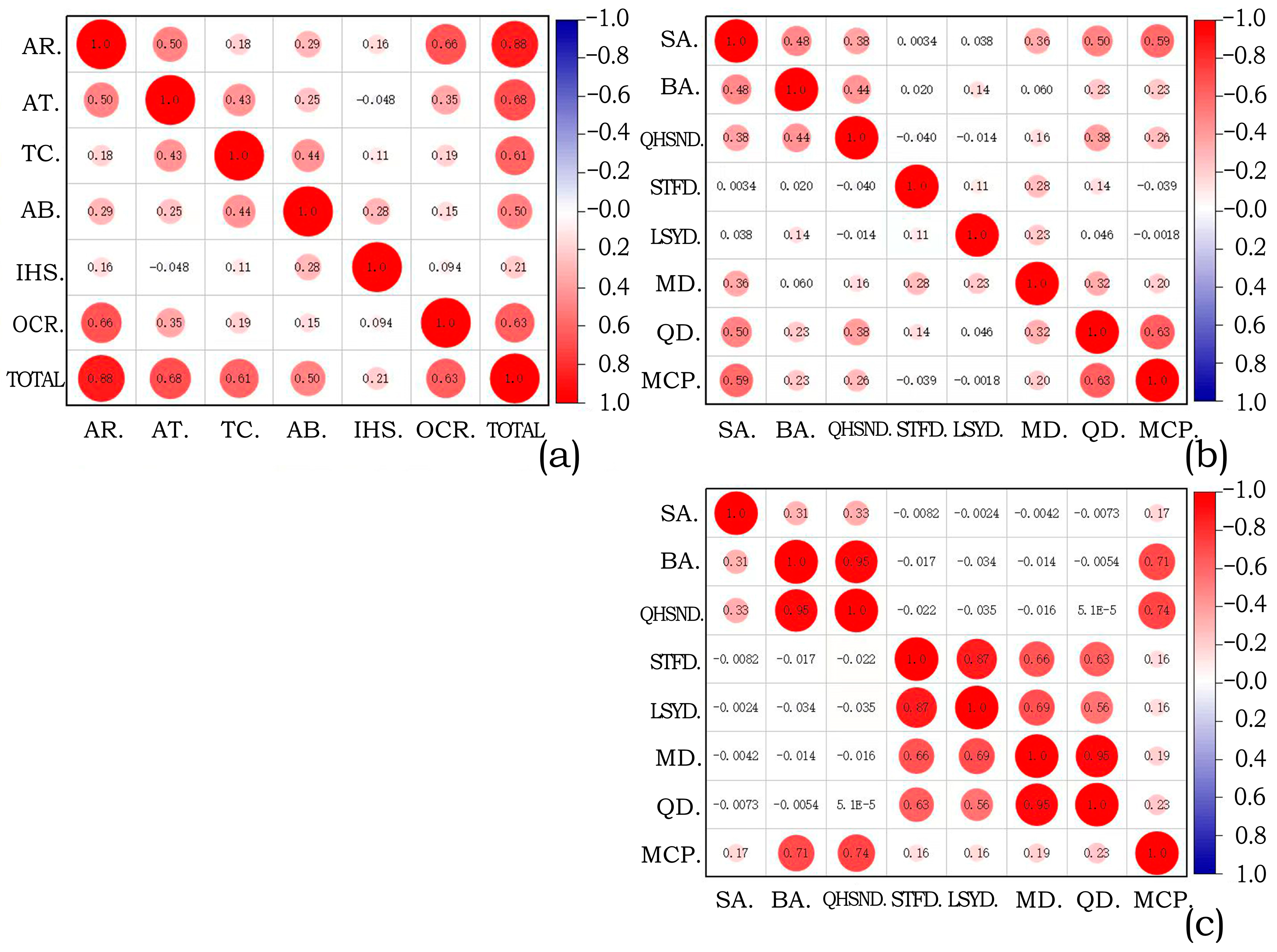
The changing distribution pattern of historical and cultural heritage in traditional Tibetan areas of China reflects the cumulative and transition of social history, and even reflects the rise and fall of civilizations [93]. There is a significant correlation between the quantity of historical and cultural heritage from the Stone Age and the Modern, Ming Dynasty, and Qing Dynasty. From a spatial clustering perspective, the clusters of historical and cultural heritage sites from the Stone Age, modern era, Qing Dynasty, and Ming Dynasty overlap, mainly in the eastern edge of the Tibetan region and the Tibetan-Han border area, while historical and cultural heritage in other areas is relatively scattered. Human and religious activities gradually shifted from simple ritual sites and caves to more complex buildings and settled tribal areas, and historical and cultural heritage gradually formed and accumulated during this process, thus the continuity of history is easily understood, manifested as linear accumulation [94] of history and cultural heritage.
However, the differences in the correlation of cross-era cultural heritage challenge the geographical continuity and the overall nature of history [95], mainly manifested in the significant correlation between the Stone Age and the Qing Dynasty, and the significant lack of correlation between the Sui and Tang Dynasties. Due to technological limitations, production and daily activities in the Stone Age were mainly concentrated in the low-altitude areas of the eastern edge of the Tibetan area [96]. Compared with the Stone Age, the Qing government established a large number of administrative institutions and military bases in the eastern edge of the Tibetan region in order to achieve practical control over the Tibetan region. Therefore, there is a significant correlation between the Stone Age and the Qing Dynasty.
Meanwhile, another phenomenon of transformative nature is the extremely weak correlation in the entropy changes of historical and cultural heritage before and after the Sui Dynasty. Before the Sui and Tang Dynasties, the complexity of historical and cultural heritage continued to increase, and spatial differentiation intensified, forming a high entropy value area centered on the Qinghai River Valley. After the Sui Dynasty, the spatial distribution pattern of historical and cultural heritage stabilized, and the high entropy growth area of historical and cultural heritage was mainly concentrated in the border towns between the Han and Tibetan regions.
The situation of local separatism in the Sui and Tang periods was broken, and with the unification of various tribes by the Tubo Dynasty, the central dynasty’s discourse power and control significantly increased compared to the Han Dynasty. There was a great degree of exchange between the local and central dynasties in terms of economy, technology, and culture, and the social form of the traditional Tibetan area underwent a transformation, with a leapfrog change in production forms and cultural exchanges. The Tubo regime strengthened its control over religious beliefs, military, and politics, leading to a highly prosperous development of social and cultural aspects. Traditional Tibetan areas experienced a leap in social structure and technological advancement. Therefore, the entropy of historical and cultural heritage exhibits a significant weak correlation.
The above is research finding on the distribution pattern of historical and cultural heritage in traditional Tibetan areas. This is not just a case study. We hope to emphasize the importance of historical and cultural heritage in regional social and historical research in this study, and validate what we call the “historical leap” pattern. Although geographic factors can to some extent explain the changes in the distribution pattern of historical and cultural heritage, the diversity of cultural heritage exceeds the stability of geographic elements, and the social processes reflected by cultural heritage have not received sufficient attention. It is necessary to conduct comprehensive research on the differences and connections between different types and periods of cultural heritage, and explore the mutual influence between the diversity of historical and cultural heritage and cultural exchange and integration.
As seen in previous studies on cultural heritage, the combination of entropy weight and analytic hierarchy process can be used to evaluate heritage value and potential [97,98], and weigh the regional cultural stratification in urban structure using the entropy of spatial form [99]. It can discuss the inherent connections between place names, population, and ethnic groups [100], and evaluate the impact of endogenous and exogenous factors on culture using information matrices [101]. However, there is still limited quantification of the dispersed distribution of cultural heritage or ancient human activities. Dispersed distribution is an important concept in systems theory and can be measured by information entropy to assess the complexity of dispersed distribution explaining the cultural accumulation in the cycles of social development [102]. Compared with clustered distribution, dispersed distribution is more likely to have the resilience to survive in adverse conditions. In a vast region, different degrees of dispersed distribution reflect differences and connections in cultural diffusion patterns under the influence of settlement survival modes in different eras. The dispersed pattern of the Liao, Song, and Yuan Dynasties in the research on the historical and cultural heritage of the Beijing-Tianjin-Hebei region can also verify this viewpoint [89].
Some scholars have analyzed the cultural routes [103] formed by the traditional urban spatial composition in Tibet and summarized the basic types of traditional Tibetan spaces, such as single-core and multi-core. Although the idea of regional spatial integrity has been accepted in the theory and practice of cultural heritage protection, there is still a lack of discussion on the formation process of Tibetan cultural routes and traditional spaces in terms of chronology [104]. The continuity of time has not received sufficient attention in cultural heritage research [105,106,107]. Some studies have found that Tibetan cultural heritage exhibits high internal consistency and cultural identity [108].
In the historical process of China, the traditional Tibetan region is closely connected to the main ethnic regions of China. The traditional Tibetan areas of China experienced political struggles between the Tubo regime and the central regime during the Sui, Tang, and Five Dynasties period [108,109]. They underwent religious movements influenced by East Asian and Central Asian cultures during the Liao, Song, and Yuan Dynasties [110,111]. In the Ming Dynasty, they transitioned from a semi-independent mode managed by the Office of Pacification and Governance to a central governance mode managed by the Office of Military Affairs [112]. In the Qing Dynasty and modern times, they transitioned from a centralized system of combining politics and religion to a system of ethnic regional autonomy with the separation of politics and religion [113]. This has formed a distribution pattern of historical and cultural heritage characterized by multi-ethnic exchanges and religious integration.
The social history of a region is a process of fluctuation and dynamic development. Geographic and climate changes over thousands of years may have influenced the cultural forms of settlements, exhibiting similar characteristics in discontinuous periods. It should be emphasized that social change occurs faster than geographic change. The distribution pattern of historical and cultural heritage is closely related to the social historical process and requires exploration from the perspectives of social geography or anthropology. The distribution pattern of historical and cultural heritage is closely related to social-historical processes, requiring exploration from the perspectives of social geography or anthropology, rather than solely relying on geographical analysis of elements. The cultural heritage of each period has accumulated over time, forming the current distribution pattern of historical and cultural heritage.
Generally, the closer the cultural heritage is to the present, the higher the likelihood of its preservation; the longer the time span, the greater the quantity of preserved cultural heritage. Through the method of entropy, we found that although cultural heritage has grown in quantity and diversity in different regions over time, the fluctuating changes in the entropy of historical and cultural heritage are also influenced by the fluctuations of social history, and even exhibit cross-generational correlations. Further exploration of this cross-generational correlation will require the use of other technical methods. The types of historical and cultural heritage represent cultural characteristics, and different types of historical and cultural heritage are concentrated in different regions, implying different cultural features in these regions [114]. Overall, this study reveals the regional variations and temporal correlations within the interior of the Qinghai-Tibet Plateau.

5. Conclusions

Historical and cultural heritage refers to the material collection created by human activities, with functions of dissemination [115], cultural value [116], and historical significance [117]. This study focuses on the traditional Tibetan regions in China, and utilizes methods such as information entropy, correlation analysis, and historical periodization to explore the temporal complexity of the historical and cultural heritage patterns, and analyze the entropy change trends in these patterns. Through this research, we confirm that the spatial distribution pattern of historical and cultural heritage can effectively reflect the social and historical development process of the region [118,119]. Although the complexity changes in cultural heritage cannot fully restore the historical processes, it contributes to a scientific understanding of the local historical background and regional development trends.
The results show the following:
(1)
The distribution pattern of historical and cultural heritage in traditional Tibetan areas of China exhibits fluctuating changes of “aggregation-dispersion-aggregation”. This distribution characteristic is closely related to the process of social and economic development and is also influenced by geographical environment and socio-economic factors.
(2)
The distribution pattern of historical and cultural heritage in traditional Tibetan areas of China has regional characteristics. Different regions have significant differences in the types of historical and cultural heritage, reflecting the differences in cultural integration and dissemination processes in each region. The Weizang region, Anduo region, and Kangba region each have distinct historical and cultural features and architectural heritage.
(3)
The changes in the distribution pattern of historical and cultural heritage in traditional Tibetan areas in China reflect the cumulative and transformative nature of social history. The quantity and entropy change of historical and cultural heritage exhibit correlations between different periods, and there are also some intergenerational differences. The distribution pattern of historical and cultural heritage in contemporary times returns back to the characteristics of the Qin-Han and Southern and Northern Dynasties and the Northern and Southern Dynasties, forming the basic pattern of the current protection of historical and cultural heritage.
In previous studies, discussions on the spatial distribution pattern of cultural heritage mainly focused on the geographical and climatic causes [21,120,121,122], while the discussion on the temporal aspects of the distribution pattern of historical and cultural heritage was limited. The important perspective of this study is to combine the analysis of the types and time periods of cultural heritage to judge the complexity of cultural heritage in different historical periods, explaining the complexity of social culture and the systematic nature of historical landscapes. This can serve as effective evidence for the regional development process of social history.
This study on the spatiotemporal distribution pattern of historical and cultural heritage in the traditional Tibetan areas of China emphasizes the systematic relationship between historical cultural heritage and ancient societies. It further validates our theoretical understanding of regional social history, which is the combination of “transition” and “cumulation”. In particular, the leapfrogging transition of history is of great value for a profound understanding of the laws of ancient social evolution.
In addition to these theoretical findings, our research also has practical value. From the perspective of a regional cultural heritage protection system, it is possible to develop integrated cultural heritage protection policies by utilizing large-scale cultural routes, which is a cross-administrative cultural strategy improving urban competitiveness [119]. The traditional Tibetan region in China can establish tourism service standards different from those in the general plain areas, creating a tourism system with bronze culture, Tubo culture, and Ming-Qing culture as the main features. The three major Tibetan regions can form cultural heritage exhibition systems with different themes. The Weizang region mainly showcases the splendid political and religious cultural history of Tubo, while the Amduo region and Kangba region mainly showcase the cultural exchange history between Tibet and the Central Plains. The vast expanse of the traditional Tibetan region is not conducive to the formation of a tourism network, but visitors can combine extensive sightseeing with in-depth experiences to better appreciate the unique culture of the traditional Tibetan region.
This study contributes to the preservation and inheritance of cultural heritage and the orderly utilization of historical heritage while also providing a reliable foundation for maximizing the protection of temporal and spatial information. This is of great significance for the rational optimization of the historical and cultural spatial pattern, the continuity of civilization, and the revitalization of culture. In addition, it is necessary to further explore the reasons for the complexity changes in cultural heritage and to investigate the causality across different eras using other technological methods. The classification of cultural heritage based on certain technical standards is insufficient to encompass the complete cultural characteristics and can also be categorized according to different social classes or professional attributes, which will be reflected in future research. The correlation between the spatial distribution of modern and early Tibetan historical and cultural heritages in terms of entropy values may be limited due to the limitations of archaeological work scope. Many early Tibetan activities still lack historical records, which may result in potential blind spots in this study. It is hoped that new evidence will be discovered in the upcoming Cultural Relics Census.

Author Contributions

Conceptualization, S.L., J.Z. and Z.Z.; methodology, S.L.; software, S.L.; validation, J.Z., Z.Z. and X.T.; formal analysis, J.Z. and S.L.; investigation, J.L.; resources, S.L.; data curation, J.L.; writing—original draft preparation, J.Z. and J.L.; writing—review and editing, S.L. and J.Z.; visualization, X.T. and Z.Z.; supervision, S.L.; project administration, X.X.; funding acquisition, X.X., S.L. and X.T. All authors have read and agreed to the published version of the manuscript.

Funding

This research was funded by “Ministry of Education Humanities and Social Science Fund Project”, grant number 23YJA760101; “Tianjin Research Innovation Project for Postgraduate Students”, grant number 2022BKY061; “Tianjin University Independent Innovation Fund Project”, grant number 2020XSC-0034.

Data Availability Statement

All supporting data are cited within the Sencion 2 Materials and Methods. Restrictions apply to the availability of these data. The heritage data was obtained from http://www.ncha.gov.cn/ (accessed on 15 July 2023) and are available with the permission of the National Cultural Heritage Administration.

Conflicts of Interest

The authors declare no conflict of interest.

References

  1. Quan, Z. The Concept of “National Unity” in Historical Records. J. Weinan Teach. Coll. (Soc. Sci.) 2003, 3, 18–19. [Google Scholar]
  2. Yong, S.; Yubo, H. Planning and Governance of Regional Historical and Cultural Space Conservation and Development: A Case Study of the Loire Valley in France. Urban Plan. Int. 2022, 37, 111–121. [Google Scholar] [CrossRef]
  3. Fei, L.; Tongqian, Z. National Culture Park: Logic, Origins and Implications. Tour. Trib. 2021, 36, 14–26. [Google Scholar] [CrossRef]
  4. Gatta, G.; Bitelli, G. A HGIS for the study of waterways: The case of Bologna as ancient city of waters. IOP Conf. Ser. Mater. Sci. Eng. 2020, 949, 012051. [Google Scholar] [CrossRef]
  5. Wenner, F.; Dang, K.A.; Hölzl, M.; Pedrazzoli, A.; Schmidkunz, M.; Wang, J.; Thierstein, A. Regional Urbanisation through Accessibility?—The “Zweite Stammstrecke” Express Rail Project in Munich. Urban Sci. 2020, 4, 2. [Google Scholar] [CrossRef]
  6. Kostopoulou, S.; Sofianou, P.K.; Tsiokanos, K. Silk Road Heritage Branding and Polycentric Tourism Development. Sustainability 2021, 13, 1893. [Google Scholar] [CrossRef]
  7. Liao, Y.; Cenci, J.; Zhang, J. Chinese Modern Architectural Heritage Resources: Perspectives of Spatial Distribution and Influencing Factors. ISPRS Int. J. Geo-Inf. 2023, 12, 358. [Google Scholar] [CrossRef]
  8. Nicu, I.C. Cultural heritage assessment and vulnerability using Analytic Hierarchy Process and Geographic Information Systems (Valea Oii catchment, North-eastern Romania). An approach to historical maps. Int. J. Disaster Risk Reduct. 2016, 20, 103–111. [Google Scholar] [CrossRef]
  9. Nicu, I.C. Tracking natural and anthropic risks from historical maps as a tool for cultural heritage assessment: A case study. Environ. Earth Sci. 2017, 76, 330. [Google Scholar] [CrossRef]
  10. Schich, M.; Song, C.; Ahn, Y.-Y.; Mirsky, A.; Martino, M.; Barabási, A.-L.; Helbing, D. A network framework of cultural history. Science 2014, 345, 558–562. [Google Scholar] [CrossRef]
  11. Jianguo, W. On professional problems of multi-scale protection of urban architectural heritage in China. City Plan. Rev. 2022, 46, 7–24. [Google Scholar]
  12. Wu, Z.; Ma, J.; Zhang, H. Spatial Reconstruction and Cultural Practice of Linear Cultural Heritage: A Case Study of Meiguan Historical Trail, Guangdong, China. Buildings 2023, 13, 105. [Google Scholar] [CrossRef]
  13. Feng, B.; Ma, Y. Network Construction for Overall Protection and Utilization of Cultural Heritage Space in Dunhuang City, China. Sustainability 2023, 15, 4579. [Google Scholar] [CrossRef]
  14. Zhang, S.Y.; Liu, J.M.; Pei, T.; Chan, C.S.; Wang, M.D.; Meng, B. Tourism value assessment of linear cultural heritage: The case of the Beijing-Hangzhou Grand Canal in China. Curr. Issues Tour. 2023, 26, 47–69. [Google Scholar] [CrossRef]
  15. Bertacchini, E.; Revelli, F. Kalos kai agathos? government quality and cultural heritage in the regions of Europe. Ann. Reg. Sci. 2021, 67, 513–539. [Google Scholar] [CrossRef]
  16. Partarakis, N.; Zabulis, X.; Patsiouras, N.; Chatjiantoniou, A.; Zidianakis, E.; Mantinaki, E.; Kaplanidi, D.; Ringas, C.; Tasiopoulou, E.; Dubois, A.; et al. Multi-Scale Presentation of Spatial Context for Cultural Heritage Applications. Electronics 2022, 11, 195. [Google Scholar] [CrossRef]
  17. Loren-Mendez, M.; Pinzon-Ayala, D.; Ruiz, R.; Alonso-Jimenez, R. Mapping Heritage: Geospatial Online Databases of Historic Roads. The Case of the N-340 Roadway Corridor on the Spanish Mediterranean. ISPRS Int. Geo-Inf. 2018, 7, 134. [Google Scholar] [CrossRef]
  18. Spinney, L. Human cycles: History as science. Nature 2012, 488, 24–26. [Google Scholar] [CrossRef]
  19. Ashrafi, B.; Kloos, M.; Neugebauer, C. Heritage Impact Assessment, beyond an Assessment Tool: A comparative analysis of urban development impact on visual integrity in four UNESCO World Heritage Properties. J. Cult. Herit. 2021, 47, 199–207. [Google Scholar] [CrossRef]
  20. Qian, C.; Su-Pei, L. Geographical Distribution and Affecting Factors of the Intangible Cultural Heritage in China. Sci. Geogr. Sin. 2013, 33, 1166–1172. [Google Scholar]
  21. Liu, C.; Kang, L. How Do Geographical Factors Affect the Distribution of Intangible Cultural Heritage: A Case Study of Xinjiang, China. Sustainability 2023, 15, 8943. [Google Scholar] [CrossRef]
  22. Zhang, J. New functionalism: Rejuvenating historical and cultural heritage through urban revival. Int. J. Anthropol. Ethnol. 2019, 3, 8. [Google Scholar] [CrossRef]
  23. Yongqi, L.; Ruixia, Y.; Pu, W.; Anlin, Y.; Guolong, C. A quantitative description of the spatial–temporal distribution and evolution pattern of world cultural heritage. Herit. Sci. 2021, 9, 80. [Google Scholar] [CrossRef] [PubMed]
  24. Chen, J.; Zhou, Y.; Liu, D.; Zhu, A.; Liu, Q. Spatial distribution characteristics of religious architecture heritages in China and the influential factors. J. Arid Land Resour. Environ. 2018, 32, 84–90. [Google Scholar]
  25. Miao, H.; Zhang, M. Spatial structure of intangible heritage in Northwest China based on GIS analysis. J. Arid Land Resour. Environ. 2014, 28, 179–186. [Google Scholar]
  26. Agnoletti, M.; Tredici, M.; Santoro, A. Biocultural diversity and landscape patterns in three historical rural areas of Morocco, Cuba and Italy. Biodivers. Conserv. 2015, 24, 3387–3404. [Google Scholar] [CrossRef]
  27. Li, M.; Wu, B.; Cai, L. Tourism development of World Heritage Sites in China: A geographic perspective. Tour. Manag. 2008, 29, 308–319. [Google Scholar] [CrossRef]
  28. Galiakberova, A.A.; Mukhametshin, A.G.; Asratyan, N.M.; Kornilova, I.V.; Galiev, R.M. Categories and methods of civilizational approach in modern philosophical and historical discourse. Rev. Amaz. Investig. 2023, 12, 202–211. [Google Scholar] [CrossRef]
  29. Hosner, D.; Wagner, M.; Tarasov, P.E.; Chen, X.; Leipe, C. Spatiotemporal distribution patterns of archaeological sites in China during the Neolithic and Bronze Age: An overview. Holocene 2016, 26, 1576–1593. [Google Scholar] [CrossRef]
  30. Nie, X.; Xie, Y.; Xie, X.X.; Zheng, L.X. The characteristics and influencing factors of the spatial distribution of intangible cultural heritage in the Yellow River Basin of China. Herit. Sci. 2022, 10, 121. [Google Scholar] [CrossRef]
  31. Sevilla, J.; Casanova-Salas, P.; Casas-Yrurzum, S.; Portales, C. Multi-Purpose Ontology-Based Visualization of Spatio-Temporal Data: A Case Study on Silk Heritage. Appl. Sci. 2021, 11, 1636. [Google Scholar] [CrossRef]
  32. Kauppinen, T.; Mantegari, G.; Paakkarinen, P.; Kuittinen, H.; Hyvonen, E.; Bandini, S. Determining relevance of imprecise temporal intervals for cultural heritage information retrieval. Int. J. Hum. Comput. Stud. 2010, 68, 549–560. [Google Scholar] [CrossRef]
  33. Yao, Y.; Wang, X.Y.; Lu, L.L.; Liu, C.S.; Wu, Q.; Ren, H.G.; Yang, S.; Sun, R.Q.; Luo, L.; Wu, K. Proportionated Distributions in Spatiotemporal Structure of the World Cultural Heritage Sites: Analysis and Countermeasures. Sustainability 2021, 13, 2148. [Google Scholar] [CrossRef]
  34. Sesana, E.; Gagnon, A.S.; Ciantelli, C.; Cassar, J.; Hughes, J.J. Climate change impacts on cultural heritage: A literature review. WIREs Rev. Clim. Chang. 2021, 12, e710. [Google Scholar] [CrossRef]
  35. Zheng, X.; Sun, W.; Huang, X.; Zang, X. Distribution of World Cultural Heritage and Human Urban Civilization. Trop. Geogr. 2018, 38, 424–431. [Google Scholar] [CrossRef]
  36. Gao, H.; Wang, Y.; Zhang, H.; Huang, J.; Yue, X.; Chen, F. Spatial Distribution and Typological Classification of Heritage Buildings in Southern China. Buildings 2023, 13, 2025. [Google Scholar] [CrossRef]
  37. Qiang, Z.; Wei, L. Heritage Area:A New Approach for the Preservation of Large-scale Cultural Landscape. China Popul. Resour. Environ. 2007, 1, 50–55. [Google Scholar]
  38. Yuan, D.; Wu, R.; Li, D.; Zhu, L.; Pan, Y. Spatial Patterns Characteristics and Influencing Factors of Cultural Resources in the Yellow River National Cultural Park, China. Sustainability 2023, 15, 6563. [Google Scholar] [CrossRef]
  39. Tong, M.; Li, B.; Li, Z. Research on the Spatial–Temporal Distribution and Morphological Characteristics of Ancient Settlements in the Luzhong Region of China. Land 2022, 11, 1579. [Google Scholar] [CrossRef]
  40. Prieto, A.J.; Silva, A.; de Brito, J.; Macias-Bernal, J.M.; Alejandre, F.J. Multiple linear regression and fuzzy logic models applied to the functional service life prediction of cultural heritage. J. Cult. Herit. 2017, 27, 20–35. [Google Scholar] [CrossRef]
  41. Pranskūnienė, R.; Zabulionienė, E. Towards Heritage Transformation Perspectives. Sustainability 2023, 15, 6135. [Google Scholar] [CrossRef]
  42. Xie, Y.; Yang, R.; Liang, Y.; Li, W.; Chen, F. The Spatial Relationship and Evolution of World Cultural Heritage Sites and Neighbouring Towns. Remote Sens. 2022, 14, 4724. [Google Scholar] [CrossRef]
  43. CAO Yongmao, L.H. Diachrony and Synchronism in the Protection of Historical Towns: Enlightenment and Thought of “Historic Urban Landscape”. Urban Dev. Stud. 2019, 26, 13–20. [Google Scholar]
  44. Deac, L.A.; Herman, G.V.; Gozner, M.; Bulz, G.C.; Boc, E. Relationship between Population and Ethno-Cultural Heritage—Case Study: Crișana, Romania. Sustainability 2023, 15, 9055. [Google Scholar] [CrossRef]
  45. Chitty, G.; Smith, C. Principles into Policy: Assessing the Impact of Conservation Principles in Local Planning Policy. Hist. Environ.-Policy Pract. 2019, 10, 282–299. [Google Scholar] [CrossRef]
  46. Liu, R.; Li, W.; Yin, X.; Zhang, W. Research on the Construction of Scenic Trails under the Background of Large Scale Homogeneous Landscape Patterns in Tibetan Regions: A Case Study of Gannan Tibetan Autonomous Prefecture. Res. Dev. 2012, 109–112. [Google Scholar] [CrossRef]
  47. Statuto, D.; Cillis, G.; Picuno, P. GIS-based Analysis of Temporal Evolution of Rural Landscape: A Case Study in Southern Italy. Nat. Resour. Res. 2019, 28, 61–75. [Google Scholar] [CrossRef]
  48. Luan, F.; Xiong, H.; Wang, F.; Wang, Z. Spatial-temporal Changes and Man-land Relationship of Cultural Heritage Sites in Xinjiang. Areal Res. Dev. 2017, 36, 134–139. [Google Scholar]
  49. Qing, W.; Gui, L.X.; Ming, Z. The Spatial Distribution and Relevant Factors of China’s Different Types Intangible Cultural Heritages. Econ. Geogr. 2015, 35, 175–183. [Google Scholar] [CrossRef]
  50. Giudici, E.; Mi Dahlgaard Park, S.; Melis, C.; Dessì, S.; Francine Pollnow Galvao Ramos, B. Is intangible cultural heritage able to promote sustainability in tourism? Int. J. Qual. Serv. Sci. 2013, 5, 101–114. [Google Scholar] [CrossRef]
  51. Wang, Q.; Li, Z.; Yin, Y.; Yang, S.; Long, W.; Lai, F.; Hu, J. Distribution characteristics of typical geological relics in the Western Sichuan Plateau. Open Geosci. 2020, 12, 307–323. [Google Scholar] [CrossRef]
  52. Chen, X.; Hou, G.; Jin, S.; Gao, J.; Duan, R. The Pollen Records of Human Activities in Qinghai-Tibet Plateau during the Middle and Late Holocene. Earth Environ. 2020, 48, 643–651. [Google Scholar]
  53. Brantingham, P.J.; Rhode, D.; Madsen, D.B. Archaeology Augments Tibet’s Genetic History. Science 2010, 329, 1467. [Google Scholar] [CrossRef] [PubMed]
  54. Lu, H.; Chen, X.; Zhang, Z.; Tang, L.; Lemoine, X.; Wangdue, S.; Chen, Z.; Liu, X.; Frachetti, M.D. Early agropastoral settlement and cultural change in central Tibet in the first millennium BC: Excavations at Bangga. Antiquity 2021, 95, 955–972. [Google Scholar] [CrossRef]
  55. Li, T.; Wu, Y.; Du, S.; Huang, W.; Hao, C. Age of Microlith human activities in Zhongba area, southwestern margin of Qinghai-Tibet Plateau. J. Beijing Norm. Univ. Nat. Sci. 2016, 52, 91–96. [Google Scholar]
  56. Zhu, Y.; Hou, G.; Lan, C.; Gao, J.; Pang, L. GIS-based analysis of traffic routes and regional division of the Qinghai-Tibetan Plateau in prehistoric period. Prog. Geogr. 2018, 37, 438–449. [Google Scholar]
  57. Zhang, D.D.; Li, S.-H. Comment on “Permanent human occupation of the central Tibetan Plateau in the early Holocene”. Science 2017, 357, eaam9231. [Google Scholar] [CrossRef]
  58. Hou, G.; Wei, H.; Chongyi, E.; Sun, Y. Human activities and environmental change in Holocene in the northeastern margin of Qinghai-Tibet Plateau: A case study of JXG2 relic site in Qinghai Lake. Acta Geogr. Sin. 2013, 68, 380–388. [Google Scholar]
  59. Gao, X.; Zhou, Z.; Guan, Y. Human cultural remains and adaptation strategies in the Tibetan Plateau margin region in the late pleistocene. Quat. Sci. 2008, 28, 969–977. [Google Scholar]
  60. Hou, G.; Cao, G.; Chongyi, E.; Ren, X.; Wuennemann, B.; Li, F. New evidence of human activities at an altitude of 4000 meters area of Qinghai-Tibet Plateau. Acta Geogr. Sin. 2016, 71, 1231–1240. [Google Scholar]
  61. Hou, G.; Zhang, X.; Xiao, J.; Chongyi, E. Human Migration and Diffusion in Northeastern Margin of the Qinghai-Tibet Plateau since the Late Glacial Period. Arid Zone Res. 2013, 30, 149–155. [Google Scholar]
  62. Song, J.; Gao, Y.; Tang, L.; Zhang, Z.; Tang, M.H.; Xu, H.; Wangyal, T.; Yuan, H.; Li, L.; Li, Y.; et al. Farming and multi-resource subsistence in the third and second millennium BC: Archaeobotanical evidence from Karuo. Archaeol. Anthropol. Sci. 2021, 13, 47. [Google Scholar] [CrossRef]
  63. Madsen, D.B.; Ma, H.; Brantingham, P.J.; Xing, G.; Rhode, D.; Zhang, H.; Olsen, J.W. The Late Upper Paleolithic occupation of the northern Tibetan Plateau margin. J. Archaeol. Sci. 2006, 33, 1433–1444. [Google Scholar] [CrossRef]
  64. Tang, L.; Lu, H.; Chen, X.; Xu, H.; Boivin, N.; Storozum, M.; Yang, F.; Li, S.; Liu, X.; Spengler, R.N., III. Prehistoric agricultural decision making in the western Himalayas: Ecological and social variables. Antiquity 2022, 96, 1214–1231. [Google Scholar] [CrossRef]
  65. Hayk, P.; Melendez Carballido, R.; Alfaro Matos, M.; Carrion Leon, K.E. Cultural genocide and the question of Tibet. Rev. Univ. Y Soc. 2022, 14, 391–397. [Google Scholar]
  66. Sinding-Larsen, A. Lhasa community, world heritage and human rights. Int. J. Herit. Stud. 2012, 18, 297–306. [Google Scholar] [CrossRef]
  67. Blanco, A.; de Bustamante, I.; Pascual-Aguilar, J.A. Using old cartography for the inventory of a forgotten heritage: The hydraulic heritage of the Community of Madrid. Sci. Total Environ. 2019, 665, 314–328. [Google Scholar] [CrossRef]
  68. Monna, F.; Rolland, T.; Denaire, A.; Navarro, N.; Granjon, L.; Barbe, R.; Chateau-Smith, C. Deep learning to detect built cultural heritage from satellite imagery.-Spatial distribution and size of vernacular houses in Sumba, Indonesia. J. Cult. Herit. 2021, 52, 171–183. [Google Scholar] [CrossRef]
  69. Wagner, M.; Tarasov, P.; Hosner, D.; Fleck, A.; Ehrich, R.; Chen, X.; Leipe, C. Mapping of the spatial and temporal distribution of archaeological sites of northern China during the Neolithic and Bronze Age. Quat. Int. 2013, 290, 344–357. [Google Scholar] [CrossRef]
  70. Park, M.; Ma, M. Sino-tibetian relationship in view of religion state and society: In a focus of national sovereignty disputes and correlative issues’ historical meaning. J. Mod. China Stud. 2014, 15, 77–116. [Google Scholar] [CrossRef]
  71. Strand, M.; Rivers, N.; Snow, B. The complexity of evaluating, categorising and quantifying marine cultural heritage. Mar. Policy 2023, 148, 105449. [Google Scholar] [CrossRef]
  72. Gao, Q.; Jones, S. Authenticity and heritage conservation: Seeking common complexities beyond the ‘eastern’ and ‘western’ dichotomy. Int. J. Herit. Stud. 2021, 27, 90–106. [Google Scholar] [CrossRef]
  73. Naguib, S.-A. Heritage in Movement: Rethinking Cultural Borrowings in the Mediterranean. Int. J. Herit. Stud. 2008, 14, 467–480. [Google Scholar] [CrossRef]
  74. Yun, C.J. The Preservation and Utilization of Cultural Heritage in the Region of Haenama—Focused on the Ancient Cultural Heritage. Baekje J. 2018, 26, 103–127. [Google Scholar]
  75. Lahdesmaki, T.; Ceginskas, V.L.A. Conceptualisation of heritage diplomacy in scholarship. Int. J. Herit. Stud. 2022, 28, 635–650. [Google Scholar] [CrossRef]
  76. Cominelli, F.; Greffe, X. Intangible cultural heritage: Safeguarding for creativity. City Cult. Soc. 2012, 3, 245–250. [Google Scholar] [CrossRef]
  77. Park, S. An Essay on the Tibetan’s Intangible Cultural Heritage. Asian Cult. Stud. 2013, 30, 116–146. [Google Scholar]
  78. Che, Y.J.; Cao, Y.; Wu, R.; Liu, J.; Chen, L.H.; Wu, J.K. Spatio-Temporal Pattern of World Heritage and Its Accessibility Assessment in China. Sustainability 2022, 14, 3033. [Google Scholar] [CrossRef]
  79. Luo, W.; Hartmann, J.F.; Wang, F. Terrain characteristics and Tai toponyms: A GIS analysis of Muang, Chiang and Viang. GeoJournal 2009, 75, 93–104. [Google Scholar] [CrossRef]
  80. Wright, W.C.C.; Eppink, F.V. Drivers of heritage value: A meta-analysis of monetary valuation studies of cultural heritage. Ecol. Econ. 2016, 130, 277–284. [Google Scholar] [CrossRef]
  81. Marzeion, B.; Levermann, A. Loss of cultural world heritage and currently inhabited places to sea-level rise. Environ. Res. Lett. 2014, 9, 034001. [Google Scholar] [CrossRef]
  82. Zhang, Y.; Zhang, H.; Sun, Z. Effects of Urban Growth on Architectural Heritage: The Case of Buddhist Monasteries in the Qinghai-Tibet Plateau. Sustainability 2018, 10, 1593. [Google Scholar] [CrossRef]
  83. Yuewei, M.A.; Yongtao, Z.; Fubin, C.; Libo, L.A.N. Impact of Yaan-kangding highway on the world natural heritage of Sichuan giant panda sanctuaries. Resour. Environ. Yangtze Basin 2011, 20, 1017–1023. [Google Scholar]
  84. Wu, P.-S.; Hsieh, C.-M.; Hsu, M.-F. Using heritage risk maps as an approach to estimating the threat to materials of traditional buildings in Tainan (Taiwan). J. Cult. Herit. 2014, 15, 441–447. [Google Scholar] [CrossRef]
  85. Runze, Y. A study on the spatial distribution and historical evolution of grotto heritage: A case study of Gansu Province, China. Herit. Sci. 2023, 11, 165. [Google Scholar] [CrossRef]
  86. Wang, X.; Zhang, J.; Cenci, J.; Becue, V. Spatial Distribution Characteristics and Influencing Factors of the World Architectural Heritage. Heritage 2021, 4, 2942–2959. [Google Scholar] [CrossRef]
  87. Chen, F.H.; Dong, G.H.; Zhang, D.J.; Liu, X.Y.; Jia, X.; An, C.B.; Ma, M.M.; Xie, Y.W.; Barton, L.; Ren, X.Y.; et al. Agriculture facilitated permanent human occupation of the Tibetan Plateau after 3600 B.P. Science 2015, 347, 248–250. [Google Scholar] [CrossRef]
  88. Shepherd, R. UNESCO and the politics of cultural heritage in Tibet. J. Contemp. Asia 2006, 36, 243–257. [Google Scholar] [CrossRef]
  89. Liu, S.; Zhang, J.; Xu, X.; Dong, J.; Li, X. Distribution pattern of historical and cultural space and entropy variation in Beijing-Tianjin-Hebei region. J. Arid. Land Resour. Environ. 2023, 37, 84–93. [Google Scholar]
  90. Rong, T.; Xu, S.; Lu, Y.; Tong, Y.; Yang, Z. Quantitative Assessment of Spatial Pattern of Geodiversity in the Tibetan Plateau. Sustainability 2023, 15, 299. [Google Scholar] [CrossRef]
  91. Xia, H.; Zhang, D.; Wang, Q.; Wu, D.; Duan, Y.; Chen, F. A study of the construction times of the ancient cities in Ganjia Basin, Gansu Province, China. J. Geogr. Sci. 2020, 30, 1467–1480. [Google Scholar] [CrossRef]
  92. Zhang, D.J.; Dong, G.H.; Wang, H.; Ren, X.Y.; Ha, P.P.; Qiang, M.R.; Chen, F.H. History and possible mechanisms of prehistoric human migration to the Tibetan Plateau. Sci. China Earth Sci. 2016, 59, 1765–1778. [Google Scholar] [CrossRef]
  93. Dong, G.; Liu, H.; Yang, Y.; Yang, Y.; Zhou, A.; Wang, Z.; Ren, X.; Chen, F. Emergence of ancient cities in relation to geopolitical circumstances and climate change during late Holocene in northeastern Tibetan Plateau, China. Front. Earth Sci. 2016, 10, 669–682. [Google Scholar] [CrossRef]
  94. Ding, M.; He, W.; Wang, T.; Shargan, W.; Zhang, M.; Cao, P.; Liu, F.; Dai, Q.; Fu, Q. A study of the mitochondrial genome of ancient inhabitants from the Latuotanggu cemetery, Tibet, China. Acta Anthropol. Sin. 2021, 40, 1–11. [Google Scholar]
  95. Correia, F.; Merlo, G. Cross-temporal grounding. Anal. Philos. 2023; early view. [Google Scholar] [CrossRef]
  96. Sun, L.; Fu, Y.; Yang, Y.; Wang, X.; Cui, W.; Li, D.; Yuan, X.; Zhang, Z.; Fu, Y.; Li, Y. Genomic Analyses Reveal Evidence of Independent Evolution, Demographic History, and Extreme Environment Adaptation of Tibetan Plateau Agaricus bisporus. Front. Microbiol. 2019, 10, 1786. [Google Scholar] [CrossRef]
  97. Del, M.S.T.T.; Tabrizi, S.K. A methodological assessment of the importance of physical values in architectural conservation using Shannon entropy method. J. Cult. Herit. 2020, 44, 135–151. [Google Scholar] [CrossRef]
  98. Meng, F.; Zhi, Y.; Pang, Y. Assessment of the Adaptive Reuse Potentiality of Industrial Heritage Based on Improved Entropy TOPSIS Method from the Perspective of Urban Regeneration. Sustainability 2023, 15, 7735. [Google Scholar] [CrossRef]
  99. Brigatti, E.; Netto, V.M.; de Sousa Filho, F.N.M.; Cacholas, C. Entropy and hierarchical clustering: Characterizing the morphology of the urban fabric in different spatial cultures. Chaos 2021, 31, 113138. [Google Scholar] [CrossRef]
  100. Zhao, F.; Fu, Y.; Luan, G.; Zhang, S.; Cai, J.; Ding, J.; Qian, J.; Xie, Z. Spatial-Temporal Characteristic Analysis of Ethnic Toponyms Based on Spatial Information Entropy at the Rural Level in Northeast China. Entropy 2020, 22, 393. [Google Scholar] [CrossRef] [PubMed]
  101. Tabacchi, M.E.; Termini, S. Birkhoff’s aesthetics, Arnheim’s entropy. Some remarks on complexity and fuzzy entropy in arts. Int. J. Comput. Intell. Syst. 2015, 8, 1103–1115. [Google Scholar] [CrossRef]
  102. Baciu, D.C. Cultural life: Theory and empirical testing. Biosystems 2020, 197, 104208. [Google Scholar] [CrossRef] [PubMed]
  103. Wei, W.; Xia, J.; Wan, B. A Study on Morphological Characteristics and Types of the Traditional Urban Spaces in Tibet. Urban Plan. Forum 2016, 4, 102–111. [Google Scholar]
  104. Wang, L. A Study on the Preservation of Linear Heritage Area of the Ancient Tea and Horse Road in Yunnan-Tibet. Geogr. Geo-Inf. Sci. 2012, 28, 101–105. [Google Scholar]
  105. Ugwuanyi, J.K.; Itanyi, E.I.; Obieluem, U.H. Heritage Ontologies in Nigeria: An Analysis of How Heritage Connects and Disconnects People. J. Afr. Archaeol. 2021, 19, 131–145. [Google Scholar] [CrossRef]
  106. Gultekin, N.T. Reading Administration Periods in Built Environment through the City of Lefke-Cyprus. Iconarp Int. J. Archit. Plan. 2020, 8, 461–479. [Google Scholar] [CrossRef]
  107. Jiyoung, J. An argument about local cultural heritage and festival planning. J. Soc. Korean Hist. Musicol. 2020, 65, 525–542. [Google Scholar]
  108. Luan, G.; Peng, Z.; Cai, J.; Fu, Y.; Song, L.; Shen, K.; Zhao, F. Spatio-Temporal Analysis on Evolution of Tibetan Human Activities in Qinghai from the Perspective of Geographic Names. J. Geomat. 2021, 46, 163–168. [Google Scholar]
  109. Hu, Y. On the strategic position of Helong Area in Gyeonggidefense in the Tang Dynasty. J. Northwest Univ. Nat. Sci. Ed. 2017, 47, 769–775. [Google Scholar]
  110. Chang, L.; Liu, R.; Jia, R. Homomorphism and isomorphism trait of Han and Tibet’s culture about the peal-linked pattern. J. Silk 2019, 56, 72–78. [Google Scholar]
  111. Lee, J. The Subsequent History of the Remaining Force of the Mongol Empire: Guan-xi Wei-suo of the Ming Dynasty. Asia Rev. 2022, 12, 375–428. [Google Scholar] [CrossRef]
  112. Lau, H.-S. The Political Status of Tibet During the Ming Dynasty: An Analysis of Some Historical Evidence. China Rep. 2019, 55, 154–171. [Google Scholar] [CrossRef]
  113. Chen, F. Transforming an Imperial Frontier: Japanese Knowledge and the Qing Empire’s New Tibet Policy. Asian Stud. Rev. 2020, 44, 422–440. [Google Scholar] [CrossRef]
  114. Zhu, H.; Liu, J.; Sang, Z.; Wei, W.; Wei, Z. Characteristic and contribution factors of different types of ethnic cultural resources: A case study of Gesar cultural and ecological protection experiment area. Acta Geogr. Sin. 2017, 72, 1118–1132. [Google Scholar]
  115. Vodopianova, E. European Cultural Heritage as a Unity of the Traditional and the Innovative. Contemp. Eur. 2019, 5, 5–12. [Google Scholar] [CrossRef]
  116. Lam-Knott, S. Contested Meanings of Urban Heritage in Hong Kong. City Soc. 2022, 34, 62–87. [Google Scholar] [CrossRef]
  117. Guzel, O.G.; Kurnaz, H.A. Pomaks Protecting Their Cultural Heritage in Anatolia: A Research on Their Socio-Cultural Experiences. Milli Folk. 2023, 18, 199–213. [Google Scholar] [CrossRef]
  118. Weinert, M.S. Reading world society phenomenologically: An illustration drawing upon the cultural heritage of humankind. Int. Politics 2017, 55, 26–40. [Google Scholar] [CrossRef]
  119. Cerreta, M.; Daldanise, G.; Giovene di Girasole, E.; Torre, C.M. A Cultural Heritage Low Entropy Enhancement Approach: An Ex Post Evaluation of Creative Practices. Sustainability 2021, 13, 2765. [Google Scholar] [CrossRef]
  120. Wang, F.; Mao, W.; Dong, Y.; Zhu, X. Implications for Cultural Landscape in a Chinese Context: Geo-analysis of Spatial Distribution of Historic Sites. Chin. Geogr. Sci. 2018, 28, 167–182. [Google Scholar] [CrossRef]
  121. Wang, Q.; Bing, H.; Wang, S.; Xu, Q. Study on the Spatial Distribution Characteristics and Influencing Factors of Famous Historical and Cultural Towns or Villages in Hubei Province, China. Sustainability 2022, 14, 13735. [Google Scholar] [CrossRef]
  122. Zhou, C.; Zhou, L.; Zhang, X. Spatial Differentiation and Driving Factors of Multi-category Intangible Cultural Heritages in China. Geogr. Geo-Inf. Sci. 2023, 39, 72–80. [Google Scholar]
Figure 1. Study area. (Self-drawn. The Chinese map is produced based on the standard map with approval number GS (2020)4621 downloaded from the website of the Ministry of Natural Resources (http://www.mnr.gov.cn, accessed on 15 July 2023), and the boundaries of the base map have not been modified).
Buildings 13 02995 g001
Figure 2. Technical route of this study (Self-drawn).
Buildings 13 02995 g002
Figure 3. Overall distribution patterns of historical and cultural heritage in multiple periods. (Self-drawn. Some standard deviation ellipses exceed the drawing range, and the displayed standard deviation ellipses can reflect the overall distribution characteristics).
Buildings 13 02995 g003
Figure 4. The autocorrelation distribution patterns of historical and cultural heritage in multiple periods (Self-drawn).
Buildings 13 02995 g004
Figure 5. Overall distribution patterns of multi-type historical and cultural heritage. (Self-drawn. Some standard deviation ellipses exceed the drawing range, and the displayed standard deviation ellipses can reflect the overall distribution characteristics).
Buildings 13 02995 g005
Figure 6. The autocorrelation distribution patterns of multi-type historical and cultural heritage (Self-drawn).
Buildings 13 02995 g006
Figure 7. Overall distribution patterns of entropy change in historical and cultural heritage in multiple periods. (Self-drawn. Some standard deviation ellipses exceed the drawing range, and the displayed standard deviation ellipses can reflect the overall distribution characteristics).
Buildings 13 02995 g007
Figure 8. The autocorrelation distribution patterns of entropy change of historical and cultural heritage in multiple periods (Self-drawn).
Buildings 13 02995 g008
Figure 9. Correlation analysis of historical and cultural heritage: (a) Correlation of different types; (b) Correlation of different periods; (c) Correlation of entropy change in multiple periods (Self-drawn).
Buildings 13 02995 g009
Table 1. Basic geographic analysis technology of this study (Self-drawn).
MethodsFormulaParameterRole
Nearest Neighbor
Index
(NNI)
When the nearest neighbor index R = 1, it means that the point-like elements tend to be randomly distributed, which is random type; NNI < 1 tends to be agglomerative distribution; NNI > 1 tends to be uniform distribution.
N N I = r 1 ¯ r E ¯
r E ¯ = 1 2 n A = 1 2 D
r 1 is the average actual nearest neighbor distance value; r E is the theoretical nearest neighbor distance; A is the area of the study area; N is the number of cultural heritage points; D is the density of cultural heritage points.To judge the distribution pattern of point elements in space.
Standard
Deviation
Ellipse
(SDE)
The larger the flatness, the more obvious the directionality of the data. Conversely, it indicates less obvious directionality; the shorter the short half axis, the more pronounced the centripetal force presented by the data. Conversely, the greater the degree of dispersion of the data.
C = v a r x c o v x , y c o v y , x v a r y = 1 n i = 1 n x ¯ i 2 i = 1 n x ¯ i y ¯ i i = 1 n x ¯ i y ¯ i i = 1 n y ¯ i 2
C is the coordinate of the standard deviation ellipse; x ¯ , y ¯ represent the arithmetic mean center of the geographic feature; x i , y i are the spatial position coordinates of the geographic feature;
θ represents the azimuth of the ellipse;
X i ,     Y i Y i are the mean center deviations;
σ x ,     σ y are the standard deviations of the x-axis and y-axis, respectively.
To describe the spatial distribution characteristics of geographical elements, including the distribution center, distribution range, density, development direction, etc.
t a n θ = i = 1 n X i 2 i = 1 n Y i 2 + i = 1 n X i 2 i = 1 n Y i 2 2 + 4 i = 1 n X i Y i 2 2 i = 1 n X i Y i
σ x = 2 i = 1 n ( X i c o s θ Y i s i n θ ) 2 n
σ y = 2 i = 1 n ( X i s i n θ Y i c o s θ ) 2 n
Spatial Autocorrelation Analysis (Moran’s I Index)When I > 0 and Z > 0, it indicates a High-High cluster. When I < 0 and Z < 0, it indicates a Low-Low cluster. When I > 0 and Z < 0, it indicates a Low-High cluster. When I < 0 and Z > 0, it indicates a High-Low cluster.
I i = n ( x i x ¯ ) j = 1 n W i j ( x j x ¯ ) i = 1 n ( x i x ¯ ) 2   ( Z ( I ) = I E I V A R I   )
n represents the number of spatial objects; W i j denotes the spatial weight matrix of unit i and j within the study area; E (I) represents the expected value of Moran’s I statistic, VAR (I) represents the variance of Moran’s I statistic.Refers to the existence of relationships between variables within a certain spatial area and the same variables in surrounding areas.
Pearson’s Correlation Analysis (PCA)The correlation coefficient is not correlated or very weakly correlated between 0−0.2; weakly correlated between 0.2–0.4; moderately correlated between 0.4–0.6; strongly correlated between 0.6–0.8; and extremely strongly correlated between 0.8–1.
ρ x , y = c o v x , y σ x σ y = i = 1 n ( x i x ¯ ) ( y i y ¯ ) i = 1 n ( x i x ¯ ) 2 i = 1 n y i y ¯ 2   ρ x , y 1,1
ρ x , y represents the correlation of two variables; x i , y i are the measurements of the random variables x and y, respectively; x ¯ and y ¯ represent the measurements of x and y, respectively; n is the number of sequences.Pearson’s correlation analysis is an indicator measure of the dependence of two variables.
Table 2. Distribution statistics of the quantity statistics of cultural heritages (Self-drawn).
RegionsCitiesNational Key Cultural Relics Protection UnitsNational Key Cultural Relics Protection UnitsMunicipal and County-Level Cultural Relics Protection UnitsOrdinary Cultural HeritageTotal
WEIZANGALI72798132
HAIXI51465782
LASA17441279341
LINZHI2108109129
NAQU21324128167
RIKAZE172416366423
SHANNAN17339246305
KANGBAABA331888599738
CHANGDU111533148207
DIQING6519939
GANZI17223591165
YUSHU7845574
ANDUOGANNAN92343356432
GUOLUO31027287
HAIBEI4142661105
HAIDONG13922
HAINAN96043527639
HUANGNAN41816237275
XINING516
Total18835837334484367
Table 3. The NNI statistics of historical and cultural heritage in multiple periods (Self-drawn).
PeriodsEra RangeQuantityAverage Actual Nearest Distance (m)NNIZ Value
The Stone Age (SA.)Before BC 50005938877.360.265−34.26
The Bronze Age (BA.)BC 5000–BC 22172222,513.850.272−37.41
The Qin-Han and Southern and Northern Dynasties (QHSND.)BC 221–AD 58117712,532.070.451−13.96
The Sui-Tang, and Five Dynasties (STFD.)AD 581–AD 9608208688.300.309−37.85
The Liao, Song, and Yuan Dynasties (LSYD.)AD 960–AD 136819618,616.240.395−16.22
The Ming Dynasty (MD.)AD 1368–AD 164459811,170.560.327−31.47
The Qing Dynasty (QD.)AD 1644–AD 18409519386.840.346−38.56
The Modern and Contemporary Period (MCP.)AD 1840–AD 194931015,909.950.358−21.62
Table 4. The NNI statistics of multi-type historical and cultural heritage (Self-drawn).
TypesFeaturesQuantityAverage Actual Nearest Distance (m)NNIZ Value
The Ancient Ruins
(AR.)
The ruins of ancient human activities, including villages, castles, and the like.18765633.400.282−59.52
The Ancient Tombs
(AT.)
The above-ground and underground structures used for burying the deceased.51611,270.870.301−30.36
Temples and Carvings
(TC.)
Religious buildings, rock paintings, stone carvings.16076839.410.314−52.60
The Ancient Buildings
(AB.)
Historically significant buildings before 1949.19619,518.050.365−16.99
The Important Historical Sites from the Modern Period
(IHS.)
Important historical relics related to modern China. 11330,640.660.537−9.41
The Other Cultural Relics
(OCR.)
Unconventional heritage with historical, cultural, and artistic value.5943,374.680.565−6.39
All Cultural Heritage Sites——43673766.290.283−90.60
Disclaimer/Publisher’s Note: The statements, opinions and data contained in all publications are solely those of the individual author(s) and contributor(s) and not of MDPI and/or the editor(s). MDPI and/or the editor(s) disclaim responsibility for any injury to people or property resulting from any ideas, methods, instructions or products referred to in the content.

