Article

Exploring the Influences of Water-Saving Practices on the Spatiotemporal Evolution of Groundwater Dynamics in a Large-Scale Arid District in the Yellow River Basin

1
College of Water Sciences, Beijing Normal University, Beijing 100875, China
2
Hubei Water Resources and Hydropower Science and Technology Promotion Center, Hubei Water Resources Research Institute, Wuhan 430070, China
3
Faculty of Architecture, Civil and Transportation Engineering, Beijing University of Technology, Beijing 100124, China
*
Authors to whom correspondence should be addressed.
Agronomy 2023, 13(3), 827; https://doi.org/10.3390/agronomy13030827
Submission received: 4 February 2023 / Revised: 7 March 2023 / Accepted: 10 March 2023 / Published: 11 March 2023

Abstract

:
Water-saving practices (WSPs) have been recognized as an effective measure for reducing agricultural water use and alleviating regional water shortages in arid irrigation districts. However, WSPs have also reduced groundwater recharge, thereby causing the depth to groundwater table (DGT) to increase. Therefore, characterizing the impact of WSPs on the spatiotemporal variability in the DGT is of paramount importance for protecting limited groundwater resources. Based on monthly DGT observation data collected from 1990 to 2015 at 206 observation wells in the Hetao Irrigation District (HID), located in Northwest China with an arid climate, the spatiotemporal variations in DGT before and after the application of WSPs were analyzed using the empirical orthogonal function (EOF) method, and the major driving factors of the spatiotemporal DGT changes were also identified using comprehensive approaches. The EOF method revealed four major spatiotemporal DGT patterns both before and after WSPs were applied; these patterns explained 71.39% and 73.99% of the total variability in the HID before and after WSPs application, respectively. In addition, the main controlling factors affecting the DGT dynamics were different before and after WSPs were applied. In terms of the associations of the DGT with the impacting factors, the meteorological factors had the strongest impact on the DGT changes on the long-term scale of 64 months; however, irrigation played a leading role at the seasonal and semiannual scales, especially after WSPs application. The soil texture significantly impacted the spatial DGT patterns, particularly at depths above 150 cm. This study provides a scientific basis for the rational development of local groundwater resources and the scientific management of water-saving irrigation measures.

1. Introduction

Water shortages are widely considered a major problem faced in the sustainable development of irrigated agriculture and economic societies in arid and semiarid areas worldwide [1,2]. Moreover, as the largest water-consuming practice, agricultural irrigation consumes approximately 70% of global freshwater, even exceeding 90% in some arid regions [3]. Thus, various water-saving practices (WSPs) aiming to improve the efficiency of irrigation water use have been applied to alleviate the contradiction between the water supply and demand [4,5,6]. Such WSPs include lining canals, leveling farmlands, improving irrigation techniques, and adjusting the planting structure. These measures indeed have made great contributions to reducing inefficient irrigation water use, improving water productivity, and promoting national economic development [7].
In addition to the above benefits, WSPs can also have negative impacts, most of which are closely related to the reduction in groundwater recharge. As is known, regional groundwater is mainly recharged by surface water seepage and precipitation infiltration. Especially in arid irrigation districts, irrigation water is the primary source of groundwater. However, the application of lining canals and water-saving irrigation reduces groundwater recharge directly, thereby changing the regional hydrological cycle [8], lowering the groundwater level [9], and affecting vegetation coverage as well as plant diversity [10]. In particular, as a key environmental factor, a decline in the groundwater level may cause a further decrease in soil water storage [11], worse groundwater quality [12], and even the degradation of the quantity and quality of agricultural drainage water [3]. Hence, a better understanding of the impacts of water-saving measures on the spatiotemporal variations in groundwater levels and the associated impacting factors is a prerequisite to realizing the sustainable utilization of groundwater and maintaining healthy ecosystems in arid and semiarid irrigation areas [13].
Analyses of groundwater dynamics and its impacting factors from the perspectives of different temporal and spatial scales have been common in groundwater research in recent years. Various methods, such as geostatistical analysis, principal component analysis, simple trend analysis, singular spectrum analysis, wavelet analysis, and causality analysis [14,15,16,17,18,19], have been used to characterize the spatiotemporal variabilities in groundwater levels. However, owing to the excessive complexity of groundwater systems, it is quite difficult to clearly understand their complicated spatiotemporal variations and corresponding processes using only a single method [1]. Moreover, the groundwater level is the result of the joint action of natural and social factors that involve temporal accumulation and spatial differentiation, so it is essential to obtain key information from groundwater monitoring data with the smallest possible amount of information loss.
Thus, as an effective method, empirical orthogonal function (EOF) analysis can be applied to extract spatial and temporal information from large multidimensional datasets while retaining most of the spatiotemporal variance in the original data [20,21,22]. Longuevergne et al. [23] used EOF analysis to extract significant temporal signals from the Rhine Valley aquifer located in France and Germany. Yu and Lin [24] comprehensively applied EOF and cross-wavelet transform analyses to explore the spatial and temporal nonlinear relationships between groundwater level changes and precipitation in the Pingtung Plain aquifer from 2005–2010. Yue et al. [1] adopted the EOF to analyze the spatiotemporal variations in the depth to groundwater table (DGT) in the Yichang Irrigation Subdistrict, China, from 2001–2010, thereby identifying the major controlling factors. Dash and Sinha [25] employed EOF, random combination, and temporal stability approaches to understand the in situ spatiotemporal DGT dynamics over an agriculture-dominated Critical Zone Observatory in the Ganga basin.
Overall, research on groundwater levels in irrigation districts has focused mainly on the spatiotemporal variations in the groundwater level, on predicting groundwater level changes, and on the impacts of the DGT on soil water, soil salt, and crop growth [26]. However, few studies have explored the impacts of WSPs on the spatiotemporal patterns of DGT in irrigation districts from a large-scale perspective. Therefore, we selected the Hetao Irrigation District (HID), the third-largest irrigation district in China, as the study area to identify the spatiotemporal changes in DGT before and after the application of WSPs as well as the driving forces of these changes; this work is highly conducive to the development of water-saving measures and to the effective utilization of groundwater. The objectives of this research were to (1) explore the spatiotemporal variations in DGT before and after the application of WSPs, (2) identify the driving forces of DGT changes before and after the application of WSPs, and (3) provide scientific insights into the regional controls on groundwater dynamics and propose reasonable water-saving measures.

2. Materials and Methods

2.1. Study Area

The HID is located in the upstream region of the Yellow River Basin in Inner Mongolia. This district can be divided into five subdistricts from west to east (Figure 1): the Wulanbuhe Irrigation Subdistrict (WBIS), the Jiefangzha Irrigation Subdistrict (JFIS), the Yongji Irrigation Subdistrict (YJIS), the Yichang Irrigation Subdistrict (YCIS), and the Wulate Irrigation Subdistrict (WTIS). The HID covers a total area of 11.2 × 10³ km2, of which more than 60% is irrigated land [27]. This area is a closed basin underlain by Quaternary sediments and has very flat terrain with a small slope of 0.02% from southwest to northeast. The soil textures become increasingly fine (e.g., silty and clay soils) in the south–north and west–east directions. The hydraulic conductivity (0.002–0.005 cm·day−1), estimated from the small hydraulic gradient of 0.1‰–0.25‰, reveals that the lateral flow of groundwater in the HID can be negligible when compared to the vertical flow (i.e., infiltration and evaporation) [4]. Under the limitations of hydrogeology conditions, excessive irrigation and poor drainage result in an increase in the groundwater level and, subsequently, an increase in the secondary soil salinity.
The study area has a typical arid and semiarid continental climate with a mean annual precipitation total of 166 mm and pan evaporation of 2280 mm, as recorded from 1990 to 2015. The average annual temperature is 8.5 °C, while the minimum and maximum temperatures are −12.2 °C, occurring in January, and 23.7 °C, occurring in July, respectively. There are 135–150 frost-free days and 3100–3300 h of sunshine per year. As an important food base for China, the main crops grown in the HID include wheat, maize, sunflowers, and sugar beet. Suffering from severe water shortages and climatic conditions, agricultural development in the HID is dependent on traditional irrigation with surface water diverted from the Yellow River [28], and the mean annual amount of water diverted is approximately 4.86 billion m3 (1990–2015). Groundwater in the HID is recharged primarily from irrigation-induced canal seepage and field infiltration; thus, the massive amount of irrigation water results in shallow groundwater depths ranging from 0.5 to 3.0 m within one year.
To conserve water for agricultural irrigation and improve water use efficiency, water-saving projects conducted by the national and local governments have been adopted in the HID since 1999 to reduce the amount of water diverted from the Yellow River. Multiple water-saving measures, such as lining canals, leveling farmlands, and adjusting the planting structures, have therefore been carried out to reduce water diversion and improve irrigation water use efficiency.

2.2. Data

2.2.1. Groundwater Depth

A total of 225 observation wells were installed in the HID to monitor the DGT every five days (i.e., on 1st, 6th, 11th, 16th, 21st, and 26th of each calendar month) from 1990 to 2015. The mean monthly DGT was determined by taking the average of the six observations corresponding to each month. With the installation of automatic monitoring wells in the HID, some original monitoring wells have been abandoned since 2010. To ensure data integrality, data from monitoring wells with a missing data rate exceeding 50% were removed, and only data from 206 monitoring wells were used in this study. The locations of these observation wells are shown in Figure 1. Therefore, our study was based on the DGTs measured at 206 monitoring wells over 312 months from 1990 to 2015 in the HID.
Four periods of the year can be identified according to the mean monthly DGT variations (1990–2015), as shown in Figure 2. The thawing period lasts approximately from mid-March to late April. During this period, groundwater is recharged with the infiltration of irrigation water and thawing water from the upper soil layers, resulting in a gradual decrease in the DGT. The crop-growing period mainly spans from late April to late September. Under the comprehensive influences of irrigation and evapotranspiration during this period, the DGT fluctuates, with a peak in June and a trough in September. However, the DGT decreases rapidly when a large amount of irrigation water is applied to leach accumulated salt from the upper soil layers during the autumn irrigation period, which lasts approximately from late September to early November. The freezing period usually spans from mid-November to mid-March of the next year, and during this time, the DGT increases due to the impact of soil freezing as the temperature falls.

2.2.2. Irrigation and Climate

Monthly water diversion data representing the five subdistricts from 1990 to 2015 were obtained from the Hetao Water Resource Administration in Inner Mongolia. Meteorological data such as temperature and precipitation data were provided by the National Meteorological Data Center “http://data.cma.cn (accessed on 4 February 2023)”, and data recorded at five meteorological stations located in the HID (as shown in Figure 1) were selected.
Potential evapotranspiration (ETp) is an indispensable process in the atmosphere, hydrosphere, and biosphere cycles. Together with precipitation, ETp determines the regional dry and wet statuses and is a key factor in estimating the ecological water demand [29]. ETp can be calculated according to the Penman–Monteith formula. Based on the principles of energy balance and the turbulent diffusion of water vapor, the formula comprehensively considers the effects of meteorological factors such as temperature, sunshine hours, relative humidity, and wind speed on evapotranspiration. This formula is widely used to estimate potential evapotranspiration at different regional scales [30]. The equation can be expressed as follows:
E T p = 0.408 D ( R n G ) + 900 T + 273 u 2 ( e s e a ) D + g ( 1 + 0.34 u 2 )
where Δ is the slope between the temperature change curve and the saturated water vapor pressure (KPa·°C−1); Rn is the net radiation on the crop surface (MJ·m⁻2·d−1); G is the soil heat flux (MJ·m⁻2·d−1); γ is the dry and wet meter constant (KPa·°C−1); T is the average temperature at 2 m (°C); u2 is the average wind speed at a 2-m height (m·s−1); es is the saturated water vapor pressure (KPa); and ea is the actual water vapor pressure (KPa).

2.2.3. Soil Texture

Here, we investigated the soil texture in the HID at different depths (10, 30, 50, 80, 150, and 250 cm). The soil particle size distribution was determined using a laser particle size meter in the soil laboratory of Beijing Normal University.

2.3. Methods

In this study, the EOF method was applied to analyze the spatiotemporal variabilities in the DGT in the HID before (1990–1999) and after (2000–2015) the application of WSPs. Then, the driving factors of the DGT changes at different temporal and spatial scales were also assessed with statistical approaches, including Pearson’s correlation analysis and gray relational analysis [31]. In addition, the cross-wavelet transform and wavelet coherence methods were also applied to reveal the nonstationary temporal lagging patterns between the DGT and precipitation, temperature, evaporation, and irrigation. The flowchart of different analytical methods used in this study is shown in Figure 3.

2.3.1. EOF Analysis

The empirical orthogonal function (EOF), first proposed by the statistician Pearson in 1902, is broadly used for data analyses and explorations of continuous variables in many disciplines. This function is analogous to the principal component analysis method but focuses only on one single variable. EOF analysis can effectively reduce the dimensionality of a dataset while preserving most of the variability in the data. More detailed information about this data-processing method can be found in the study of Yue et al. [1].

2.3.2. Cross-Wavelet Transform and Wavelet Coherence

To understand how changes in evaporation, temperature, precipitation, and irrigation patterns can affect the DGT, a bivariate wavelet analysis was used to examine the relationships in the temporal and spatial frequency between two time series and to illustrate how the phase angle can represent the mechanism of the causal and physical relationships between the time series [24]. In this study, the cross-wavelet transform (XWT) method was applied to identify the cross-wavelet spectra of two time series, Xn and Yn; the XWT function is defined as follows:
W n X Y ( s ) = W n X ( s ) W n Y * ( s )
where W n X ( s ) denotes the wavelet transform of time series Xn at frequency scale s and W n Y * ( s ) is the complex conjugate of W n Y ( s ) for time series Yn.
Then, the cross-wavelet transform of the background power spectra of two time series Xn and Yn can be expressed as follows:
D W n X ( s ) W n Y * ( s ) s X s Y < p = Z v ( p ) v P k X P k Y
where Zv(p) is the confidence level associated with the probability p, σX, and σY are the standard deviations of two time series Xn and Yn, and Pk is the background power spectra.
In addition, wavelet coherence (WTC) was used to calculate the coefficient of coherence, which can show the changes in the relationships between two time series at multiple time scales. The WTC can be calculated as follows:
R n ( s ) = S ( s 1 W n X Y ( s ) ) S ( s 1 W n X ( s ) 2 ) S ( s 1 W n Y ( s ) 2 )
S ( W ) = S s c a l e ( S t i m e ( W n ( s ) ) )
where Rn(s) is the coefficient of coherence, S is a smoothing operator, Sscale is the smoothing function along the wavelet scale axis, and Stime is the temporal smoothing function.
In this study, the XWT and CWT methods were both applied to analyze the relationships between some impacting factors and the DGT. Detailed descriptions of the cross-wavelet transform and wavelet coherence methods are given in Grinsted et al. [32].

3. Results

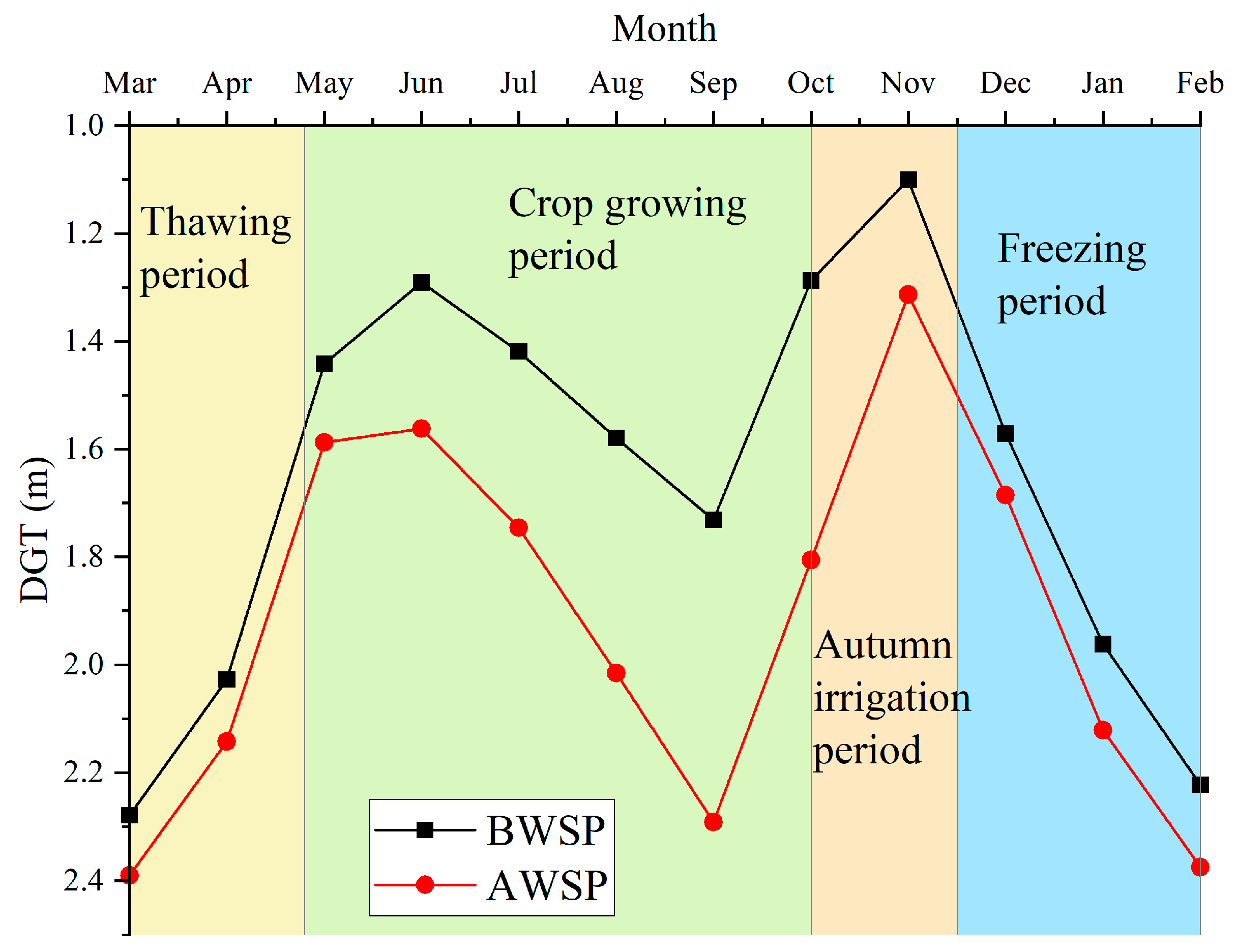
3.1. Spatiotemporal Mean of and Variability in the DGT

A significant DGT variability range can be seen in Figure 4a; as the figure shows, the DGT ranged from 0.79 m to 3.04 m in 1990 but from 0.36 m to 8.67 m in 2015. Additionally, the mean DGT showed an increasing pattern, from 1.61 m in 1990 to 2.14 m in 2015. Particularly since 2001, the maximum DGT has exhibited a distinctive increasing trend, resulting in sharply increasing variability. As shown in Figure 4b, the spatial mean of the annual DGT was further explored to understand its relationship with the corresponding coefficient of variation (CV). The CV of the DGT before the application of WSPs (1990–1999) ranged from 0.22 to 0.26 with an average value of 0.24; however, this range became 0.26 to 0.50 with an average value of 0.39 after WSPs were applied (2000–2015). Moreover, the CV of the DGT followed a cubic trend with the spatial mean, revealing that the CV was obviously positively correlated with the spatial mean DGT within a certain range. Otherwise, the CV would have decreased as the DGT increased [25].

3.2. Spatiotemporal DGT Patterns before and after the Application of WSPs

According to the monthly DGTs recorded at 206 monitoring wells in the HID, 206 EOF/EC modals before and after the WSP were obtained. According to the EOF analysis method, the first four eigenvalues before and after the application of WSPs passed the North significance test, and the cumulative variance contribution rates were 71.39% and 73.99%, respectively (Table 1). Therefore, the first four eigenvalues before and after the application of WSPs can explain the DGT changes in the HID well.
Kriging interpolation was used to analyze the monthly EOFs before and after the application of WSPs in the HID, and the spatial distribution of EOFs and the temporal changes in ECs are shown in Figure 5 and Figure 6, respectively. BWSP-EOF1 was the main spatial distribution pattern of the DGT, explaining 59.15% of the total DGT variability from 1990 to 1999. Moreover, in BWSP-EOF1, all the positive values of the spatial pattern indicated the same change trend (increase or decrease) of the monthly DGT throughout the HID. The temporal pattern of EC1 revealed that the regional DGT exhibited regular fluctuations that were highly consistent with the change in the mean DGT. BWSP-EOF2 showed a reverse distribution pattern in the DGT between the eastern and western regions of the HID; this pattern may have been related to terrain changes (higher in the western area and lower in the eastern area). BWSP-EOF3 and EOF4 reflected only some local spatial distribution patterns of the monthly DGT, revealing a nonuniform variability in attributes in the HID.
After the application of WSPs, the spatial distribution pattern of EOF1 contributed 36.73% of the total variability in the DGT. In AWSP-EOF1, the EOF values were nearly all negative, also indicating that the changing trend of the monthly DGT was highly consistent. Nevertheless, as shown in Figure 5 and Figure 6, the spatiotemporal pattern of AWSP-EOF1/EC1 was completely opposite that of BWSP-EOF1/EC1, revealing an inverse change in the DGT before and after the application of WSPs. AWSP-EOF2 was positive in most areas and negative only in the northern region of the JFIS and the central-eastern region of the WTIS, showing a reverse distribution pattern between some local areas and most areas in the HID. Similar to BWSP-EOF3 and EOF4, AWSP-EOF3 and EOF4 reflected only some local spatial distribution patterns in the monthly DGT. In summary, the predominant advantage of AWSP-EOF1 was not significant compared to that of AWSP-EOF2 from the perspective of the variance contribution rate, suggesting a higher degree of variability in the DGT following the application of WSPs.

3.3. Analysis of Driving Forces on the Change in the Temporal Variation in the DGT

On a long time scale, groundwater level fluctuations are mainly controlled by meteorological factors and anthropogenic activities maintaining the dynamic balance of groundwater [33,34]. However, the main driving forces of DGT changes on relatively short time scales (i.e., hourly, daily, and monthly scales) are not very clear, especially from the perspective of hydrology [1]. Considering that EOF1 had a large variance contribution rate and EC1 had a strong correlation with the mean DGT, only EOF1/EC1 in different periods was selected to determine the influencing factors of the monthly DGT changes using statistical methods.
To quantitatively analyze the impact factors affecting EC1, gray relational analysis was used to determine the relationship between the EC1 change and ETP, irrigation, temperature, and precipitation in two different time periods: the calendar year (all months from 1990 to 2015) and the irrigation period (April to November from 1990 to 2015). Figure 7 shows that precipitation and ETp had a stronger impact on BWSP-EC1 than any other factors, and irrigation played a leading role in controlling AWSP-EC1. In addition, the gray relational coefficients between BWSP-EC1 and precipitation and irrigation were relatively large from May to July, and the coefficients between BWSP-EC1 and ETp or temperature appeared relatively large from August to November. After the application of WSPs, the gray relational coefficients between EC1 and irrigation from April to September were greater than those between EC1 and ETp, indicating that the impact of irrigation was greater than that of ETp during the summer irrigation period.
The gray relational degrees between BWSP-EC1 and ETP, irrigation, temperature, and precipitation were 0.595, 0.562, 0.560, and 0.609 during the whole period (1990–1999) and 0.661, 0.624, 0.630, and 0.674 during the irrigation period, respectively. After the application of WSPs, the gray relational degrees between AWSP-EC1 and ETP, irrigation, temperature, and precipitation were 0.643, 0.698, 0.633, and 0.641 during the whole period (2000–2015) and 0.627, 0.713, 0.628, and 0.620 during the irrigation period, respectively. These gray relational degree results also proved that the impacts of meteorological factors were significant before the application of WSPs and that irrigation had a prominent impact on the DGT change after the application of WSPs, thereby reflecting that the WSPs had a certain effect on the DGT change in the HID.
The results of the cross-wavelet coherence analysis obtained in this study are presented in Figure 8 and Figure 9. The 95% confidence intervals of the relationships are shown within the area surrounded by the thick line. In Figure 8, significant associations between the DGT and the four driving factors can occur at high frequencies from 9 months to 15 months. Among them, clear associations were observed during the 12-month period consistently from 1990 to 2015. After the introduction of WSPs, as the DGT increased, these associations appeared to slightly weaken compared to those before the WSPs were applied. It should be noted that the association between the DGT and irrigation also occurred on a time scale of approximately 6 months, especially after the application of WSPs, indicating that irrigation had a significant impact on the variation in the DGT during the crop growth period.
As shown in Figure 9, significant correlations between the annual DGT and the four impacting factors were also observed during the entire study period. Furthermore, significantly high correlations between the DGT and meteorological factors, i.e., ETp and precipitation, were also observed at a relatively low frequency (over 64 months). However, the correlation presented stronger seasonality at the time scale of 3 months between the DGT and irrigation; this finding was consistent with the timing of irrigation events. Additionally, jointly considering the arrows in the figure, a false result was observed in which the changes in DGT had negative correlations with the ETp and temperature under the comprehensive influence of these factors at the intra-annual scale. However, a significant positive correlation between DGT and ETp was present at a low frequency on the 64-month scale. Thus, these findings revealed that meteorological factors more strongly impacted the variations in DGT at longer timescales, while irrigation played a leading role on shorter timescales, i.e., at the intra-annual scale, especially after the introduction of WSPs.

3.4. Analysis of Impacting Factors on the Spatial Patterns of DGT Changes

The soil texture varies greatly spatially, and these variations are related to groundwater recharge [35], groundwater evaporation [36], and soil moisture [37], thereby influencing groundwater level fluctuations. In the HID, irrigation canal systems cover almost the whole study area, thus ensuring the uniformity of irrigation. Hence, irrigation can hardly affect the spatial variations in the DGT. To identify the influence of the soil texture on the spatial DGT changes, representative soils at different depths were analyzed. The results showed that the soils consisted mainly of silty loams in the HID and that sand, silt, and clay accounted for 28%, 51%, and 21%, respectively, of the soils.
Figure 10 shows the correlation analysis results obtained among BWSP-EOF1, AWSP-EOF1, and the soil textures at different depths. BWSP-EOF1 had a significant negative correlation with the sand fraction but positive correlations with the silt and clay fractions. Overall, all the relationships increased with increasing soil depth. AWSP-EOF1 was significantly positively correlated with the sand content, had a significant negative correlation with silt components above a depth of 150 cm, and had a negative correlation with the clay fraction. In addition, at any depth, the coefficient between BWSP-EOF1 and sandy soil was the largest, followed by those between BWSP-EOF1 and silt and between BWSP-EOF1 and clay. Nevertheless, the coefficient between AWSP-EOF1 and silt was the largest, followed by those between AWSP-EOF1 and sand and between AWSP-EOF1 and clay, except at a depth of 250 cm. The change in the correlation between EOF1 and the soil texture indicated that a smaller sand fraction led to a decrease in the pore size with increasing soil depth, thereby influencing groundwater recharge and increasing the spatial variability in the DGT.

4. Discussion

In this study, we identified the driving forces affecting the spatial and temporal changes in DGT in the HID. Existing studies have shown that groundwater dynamics are driven primarily by climate change and anthropogenic activities [38,39]. The water cycle of the Earth system is likely accelerated by global warming, which consequently leads to changes in the evapotranspiration and precipitation rates, thereby resulting in corresponding variations in groundwater recharge [13,40]. In addition to precipitation infiltration recharge, groundwater is also recharged by surface water leakage, such as river lateral seepage and irrigation infiltration. Groundwater recharge is also highly dependent on vegetation cover and hydrogeological conditions. However, compared to climate change, anthropogenic activities may be stronger drivers of groundwater system alterations in some arid and semiarid regions [41,42].
In the research of Yue et al. [1], meteorological factors were found to have a more significant impact on groundwater level fluctuations than irrigation throughout the whole study period, regardless of whether the intra-annual scale or the interannual scale was considered. The authors focused only on the phenomenon following the introduction of WSPs in a small-scale region. However, in this work, we found that the driving factors varied before and after the application of WSPs in a large-scale irrigation district; that is, meteorological factors played a prevailing role in the temporal DGT variations before the introduction of WSPs, while, conversely, the impact of irrigation was stronger after the application of WSPs, especially during the irrigation period. In fact, the meteorological and anthropogenic factors co-occurred at the intra-annual scale, particularly through the irrigation period, and these factors might have aggregated or mitigated the other’s effects or simply exerted alternate influences. Moreover, climate change may tend to have long-term impacts on the temporal DGT variations, as shown in Figure 9, consistent with the study of Su et al. [43]. Those authors found that, from 1985 to 2013, evaporation had a stronger impact on the multiyear average groundwater level change than irrigation.
Likewise, according to the previously analyzed results, the soil texture was a key factor affecting the spatial DGT variations. In the study by Yue et al. [1], significant negative correlations were found between the spatial patterns of EOF1 and the sand fraction, while strong positive correlations were identified between the spatial patterns of EOF1 and the silt and clay fractions. These results were in line with our conclusions obtained before the introduction of WSPs. However, the sand fraction had a positive relationship with the main EOF1 distribution of the DGT after the application of WSPs, which was consistent with the results of the study by Dash and Sinha [25]. This may have been related to the scale of the study area, the number of monitoring wells, and the increasing groundwater depth resulting from the WSPs. Certainly, other factors contributed to the spatial DGT variations. Aguilar et al. [44] reported strong linear relationships between the mean and maximum NDVI and groundwater levels in dry years; however, the relationships were much weaker in wet years. In the study of Fu and Burgher [45], groundwater was important in the NDVI splitting process in situations when the weather was relatively cool and wet, such as in dense riparian zones.
Overall, with the implementation of WSPs, both the DGT and its variability increased gradually, thereby affecting the changes in the DGT-driving factors. As in the previously analyzed results, meteorological factors had more significant effects on groundwater dynamics before the introduction of WSPs than after; however, irrigation played a dominant role after the introduction of WSPs. This was mainly because WSPs reduced the amount of irrigation water diverted from the Yellow River and caused the groundwater recharge amount to decrease, thereby resulting in a decline in the groundwater level. Moreover, the reduced water diversion and the drop in the groundwater level also caused the declining regional ET observed in the HID by Chen et al. [46]. Meanwhile, Chen et al. [46] found that more groundwater was consumed to meet the crop water demand with the reduced irrigation water from the Yellow River. Thus, it is extremely important to emphasize that a reasonable increase in the DGT is beneficial to the sustainable development of regional agriculture. Therefore, the optimal WSPs, such as the conjunctive use of surface water and groundwater as reported by Xu et al. [4] and Yue et al. [5], will be of vital importance to keep the dynamic balance of groundwater level under the comprehensive influence of meteorological factors and irrigation.

5. Conclusions

In this study, the spatiotemporal variations in DGT before the introduction of WSPs (1990–1999) and after WSPs were applied (2000–2015) were analyzed by using the EOF method and wavelet analysis, and the major driving factors of DGT changes were also assessed with statistical approaches. The approach proposed herein identified the four major spatiotemporal DGT processes in the HID before and after the application of WSPs, accounting for 71.39% and 73.99% of the global variance, respectively. Furthermore, the driving forces exhibited obvious changes under the influence of the WSPs; that is, the impacts of meteorological factors were significant before the introduction of WSPs, while irrigation had a significant impact on DGT changes after the application of WSPs at the intra-annual scale. On the other hand, the significant correlations indicated that the meteorological factors had relatively strong impacts on the DGT changes at longer time scales; however, irrigation played a leading role on shorter time scales, especially after the introduction of WSPs. The soil texture was shown to be highly correlated with the spatial DGT pattern, revealing that the varied soil texture led to changes in the pore size, thereby influencing the groundwater recharge process and increasing the spatial variability in the DGT. Our analysis provides evidence about the spatiotemporal variations in DGT and the driving forces behind those variations under the impacts of WSPs. Due to the limitation of data, this study only analyzed the impact of soil texture on spatial patterns such as terrain; hydraulic conductivity and land use type should be considered in future work. Additionally, from this work, it can be said that the impact of WSPs on the hydrological cycle and the optimization of irrigation practices should be developed in consideration of maintaining balanced groundwater dynamics.

Author Contributions

W.Y. made important contributions to the conceptualization, methodology, investigation, writing—original draft preparation, and funding acquisition. H.Z. was responsible for the investigation, validation, review, and revisions. Z.Z. wrote a part of the original draft and reviewed it. M.G. was responsible for the formal analysis, visualization, and writing—review and editing. F.W. and L.Z. were responsible for software, validation, and data curation. J.W. improved the research ideas and revised the manuscript. All authors have read and agreed to the published version of the manuscript.

Funding

This study was funded by the National Key Research and Development Program of China (Grant No. 2021YFC3201204) and the National Natural Science Foundation of China (Grant No. 52179032&51879011).

Data Availability Statement

Not applicable.

Acknowledgments

The authors are grateful for the support from the Experimental Station of Yichang Sub-center of Water Development Center of Hetao Irrigation District in Inner Mongolia.

Conflicts of Interest

The authors declare no conflict of interest.

References

  1. Yue, W.; Meng, K.; Hou, K.; Zuo, R.; Zhang, B.-T.; Wang, G. Evaluating climate and irrigation effects on spatiotemporal variabilities of regional groundwater in an arid area using EOFs. Sci. Total Environ. 2020, 709, 136147. [Google Scholar] [CrossRef]
  2. Zhou, X.; Zhang, Y.; Sheng, Z.; Manevski, K.; Andersen, M.N.; Han, S.; Li, H.; Yang, Y. Did water-saving irrigation protect water resources over the past 40 years? A global analysis based on water accounting framework. Agric. Water Manag. 2021, 249, 106793. [Google Scholar] [CrossRef]
  3. Hu, Q.; Yang, Y.; Han, S.; Wang, J. Degradation of agricultural drainage water quantity and quality due to farmland expansion and water-saving operations in arid basins. Agric. Water Manag. 2019, 213, 185–192. [Google Scholar] [CrossRef]
  4. Xu, X.; Huang, G.; Qu, Z.; Pereira, L.S. Assessing the groundwater dynamics and impacts of water saving in the Hetao Irrigation District, Yellow River basin. Agric. Water Manag. 2010, 98, 301–313. [Google Scholar] [CrossRef]
  5. Yue, W.; Liu, X.; Wang, T.; Chen, X. Impacts of water saving on groundwater balance in a large-scale arid irrigation district, Northwest China. Irrig. Sci. 2016, 34, 297–312. [Google Scholar] [CrossRef]
  6. Perry, C.; Steduto, P.; Karajeh, F. Does Improved Irrigation Technology Save Water? A Review of the Evidence, in Discussion Paper on Irrigation and Sustainable Water Resources Management in the Near East and North Africa; Food and Agriculture Organization of the United Nations: Cairo, Egypt, 2017; p. 2017. [Google Scholar]
  7. Xue, J.; Guan, H.; Huo, Z.; Wang, F.; Huang, G.; Boll, J. Water saving practices enhance regional efficiency of water consumption and water productivity in an arid agricultural area with shallow groundwater. Agric. Water Manag. 2017, 194, 78–89. [Google Scholar] [CrossRef]
  8. Yin, X.; Feng, Q.; Zheng, X.; Wu, X.; Zhu, M.; Sun, F.; Li, Y. Assessing the impacts of irrigated agriculture on hydrological regimes in an oasis-desert system. J. Hydrol. 2021, 594, 125976. [Google Scholar] [CrossRef]
  9. Porhemmat, J.; Nakhaei, M.; Dadgar, M.A.; Biswas, A. Investigating the effects of irrigation methods on potential groundwater recharge: A case study of semiarid regions in Iran. J. Hydrol. 2018, 565, 455–466. [Google Scholar] [CrossRef]
  10. Horton, J.L.; Kolb, T.E.; Hart, S.C. Physiological response to groundwater depth varies among species and with river flow regulation. Ecol. Appl. 2000, 11, 1046–1059. [Google Scholar] [CrossRef]
  11. Kisekka, I.; Schlegel, A.; Ma, L.; Gowda, P.H.; Prasad, P.V.V. Optimizing preplant irrigation for maize under limited water in the High Plains. Agric. Water Manag. 2017, 187, 154–163. [Google Scholar] [CrossRef]
  12. Mi, L.; Tian, J.; Si, J.; Chen, Y.; Li, Y.; Wang, X. Evolution of Groundwater in Yinchuan Oasis at the Upper Reaches of the Yellow River after Water-Saving Transformation and Its Driving Factors. Int. J. Environ. Res. Public Health 2020, 17, 1304. [Google Scholar] [CrossRef] [Green Version]
  13. Tsai, J.P.; Chang, L.C.; Chang, P.Y.; Lin, Y.C.; Chen, Y.C.; Wu, M.T.; Yu, H.L. Spatial-temporal pattern recognition of groundwater head variations for recharge zone identification. J. Hydrol. 2017, 549, 351–362. [Google Scholar] [CrossRef]
  14. Ahmadi, S.H.; Sedghamiz, A. Geostatistical analysis of spatial and temporal variations of groundwater level. Environ. Monit. Assess. 2007, 129, 277–294. [Google Scholar] [CrossRef]
  15. Sun, Y.; Kang, S.; Li, F.; Zhang, L. Comparison of interpolation methods for depth to groundwater and its temporal and spatial variations in the Minqin oasis of northwest China. Environ. Model. Softw. 2009, 24, 1163–1170. [Google Scholar] [CrossRef]
  16. Mangiarotti, S.; Sekhar, M.; Berthon, L.; Javeed, Y.; Mazzega, P. Causality analysis of groundwater dynamics based on a Vector Autoregressive model in the semi-arid basin of Gundal (South India). J. Appl. Geophys. 2012, 83, 1–10. [Google Scholar] [CrossRef] [Green Version]
  17. Chen, L.; Feng, Q. Geostatistical analysis of temporal and spatial variations in groundwater levels and quality in the Minqin oasis, Northwest China. Environ. Earth Sci. 2013, 70, 1367–1378. [Google Scholar] [CrossRef]
  18. Polomčić, D.; Gligorić, Z.; Bajić, D.; Cvijović, Č. A hybrid model for forecasting groundwater levels based on fuzzy C-mean clustering and singular spectrum analysis. Water 2017, 9, 541. [Google Scholar] [CrossRef] [Green Version]
  19. Zereg, S.; Boudoukha, A.; Benaabidate, L. Impacts of natural conditions and anthropogenic activities on groundwater quality in Tebessa plain, Algeria. Sustain. Environ. Res. 2018, 28, 340–349. [Google Scholar] [CrossRef]
  20. Kim, K.Y.; North, G.R. EOF-based linear prediction algorithm: Examples. J. Climate 1999, 12, 2076–2092. [Google Scholar] [CrossRef]
  21. Griffiths, M.L.; Bradley, R.S. Variations of twentieth-century temperature and precipitation extreme indicators in the northeast United States. J. Clim. 2007, 20, 5401–5417. [Google Scholar] [CrossRef]
  22. Yu, H.L.; Chu, H.J. Understanding space–time patterns of groundwater system by empirical orthogonal functions: A case study in the Choshui River alluvial fan, Taiwan. J. Hydrol. 2010, 381, 239–247. [Google Scholar] [CrossRef]
  23. Longuevergne, L.; Florsch, N.; Elsass, P. Extracting coherent regional information from local measurements with Karhunen-Loève transform: Case study of an alluvial aquifer (Rhine valley, France and Germany). Water Resour. Res. 2007, 43, W04430. [Google Scholar] [CrossRef] [Green Version]
  24. Yu, H.L.; Lin, Y.C. Analysis of space–time non-stationary patterns of rainfall–groundwater interactions by integrating empirical orthogonal function and cross wavelet transform methods. J. Hydrol. 2015, 525, 585–597. [Google Scholar] [CrossRef]
  25. Dash, S.K.; Sinha, R. Space-time dynamics of soil moisture and groundwater in an agriculture-dominated critical zone observatory (CZO) in the Ganga basin, India. Sci. Total Environ. 2022, 851, 158231. [Google Scholar] [CrossRef]
  26. Wang, W.; Xue, X.; Geng, W. Spatial variability of groundwater level in Hetao irrigation area and its Kriging estimation. J. Irrig. Drain. Eng. 2007, 26, 18–21. [Google Scholar]
  27. Chen, H.; Huo, Z.; Zhang, L.; White, I. New perspective about application of extended Budyko formula in arid irrigation district with shallow groundwater. J. Hydrol. 2020, 582, 124496. [Google Scholar] [CrossRef]
  28. Chen, H.; Liu, Z.; Huo, Z.; Qu, Z.; Xia, Y.; Fernald, A. Impacts of agricultural water saving practice on regional groundwater and water consumption in an arid region with shallow groundwater. Environ. Earth Sci. 2016, 75, 1–15. [Google Scholar] [CrossRef]
  29. Allen, R.G.; Pereira, L.S.; Raes, D.; Smith, M. Crop evapotranspiration-Guidelines for computing crop water requirements-FAO Irrigation and drainage paper 56. FAO Rome 1998, 300, D05109. [Google Scholar]
  30. Chi, D.; Wang, H.; Li, X.; Liu, H.; Li, X. Estimation of the ecological water requirement for natural vegetation in the Ergune River basin in Northeastern China from 2001 to 2014. Ecol. Indic. 2018, 92, 141–150. [Google Scholar] [CrossRef]
  31. Xu, W.; Du, S. Information entropy evolution for groundwater flow system: A case study of artificial recharge in Shijiazhuang City, China. Entropy 2014, 16, 4408–4419. [Google Scholar] [CrossRef] [Green Version]
  32. Grinsted, A.; Moore, J.C.; Jevrejeva, S. Application of the cross wavelet transform and wavelet coherence to geophysical time series. Nonlinear Process Geophys. 2004, 11, 561–566. [Google Scholar] [CrossRef]
  33. Yu, R.; Liu, T.; Xu, Y.; Zhu, C.; Zhang, Q.; Qu, Z.; Liu, X.; Li, C. Analysis of salinization dynamics by remote sensing in Hetao Irrigation District of North China. Agric. Water Manag. 2010, 97, 1952–1960. [Google Scholar] [CrossRef]
  34. Wunsch, A.; Liesch, T.; Broda, S. Forecasting groundwater levels using nonlinear autoregressive networks with exogenous input (NARX). J. Hydrol. 2018, 567, 743–758. [Google Scholar] [CrossRef]
  35. Zomlot, Z.; Verbeiren, B.; Huysmans, M.; Batelaan, O. Spatial distribution of groundwater recharge and base flow: Assessment of controlling factors. J. Hydrol. Reg. Stud. 2015, 4, 349–368. [Google Scholar] [CrossRef] [Green Version]
  36. Lehmann, P.; Merlin, O.; Gentine, P.; Or, D. Soil texture effects on surface resistance to bare-soil evaporation. Geophys. Res. Lett. 2018, 45, 10398–10405. [Google Scholar] [CrossRef]
  37. Yinglan, A.; Wang, G.; Liu, T.; Xue, B.; Kuczera, G. Spatial variation of correlations between vertical soil water and evapotranspiration and their controlling factors in a semi-arid region. J. Hydrol. 2019, 574, 53–63. [Google Scholar]
  38. Vorosmarty, C.J.; Green, P.; Salisbury, J.; Lammers, R.B. Global water resources: Vulnerability from climate change and population growth. Science 2000, 289, 284–288. [Google Scholar] [CrossRef] [PubMed] [Green Version]
  39. Ding, Z.; Koriem, M.A.; Lbrahim, S.M.; Antar, A.S.; Ewis, M.A.; He, Z.; Kheir, A.M.S. Seawater intrusion impacts on groundwater and soil quality in the northern part of the Nile Delta, Egypt. Environ. Earth Sci. 2020, 79, 313. [Google Scholar] [CrossRef]
  40. Yue, W.; Wang, T.; Franz, T.E.; Chen, X. Spatiotemporal patterns of water table fluctuations and evapotranspiration induced by riparian vegetation in a semiarid area. Water Resour. Res. 2016, 52, 1948–1960. [Google Scholar] [CrossRef] [Green Version]
  41. Dai, J.; Cui, Y.; Cai, X.; Brown, L.C.; Shang, Y. Influence of water management on the water cycle in a small watershed irrigation system based on a distributed hydrologic model. Agric. Water Manag. 2016, 174, 52–60. [Google Scholar] [CrossRef]
  42. Schlosser, C.A.; Strzepek, K.; Gao, X.; Fant, C.; Blanc, É.; Paltsev, S.; Jacoby, H.; Reilly, J.; Gueneau, A. The future of global water stress: An integrated assessment. Earths Future 2014, 2, 341–361. [Google Scholar] [CrossRef]
  43. Su, Y.; Feng, S.; Wang, J.; Xu, Y. Analysis of groundwater table depth distribution and its influencing factors in Hetao irrigation area, Inner Mongolia. China Rural. Water Hydropower 2017, 7, 33–37. [Google Scholar]
  44. Aguilar, C.; Zinnert, J.C.; Polo, M.J.; Young, D.R. NDVI as an indicator for changes in water availability to woody vegetation. Ecol. Indic. 2012, 23, 290–300. [Google Scholar] [CrossRef]
  45. Fu, B.; Burgher, I. Riparian vegetation NDVI dynamics and its relationship with climate, surface water and groundwater. J. Arid. Environ. 2015, 113, 59–68. [Google Scholar] [CrossRef]
  46. Chen, H.; Huo, Z.; Dai, X.; Ma, S.; Xu, X.; Huang, G. Impact of agricultural water-saving practices on regional evapotranspiration: The role of groundwater in sustainable agriculture in arid and semi-arid areas. Agric. For. Meteorol. 2018, 263, 156–168. [Google Scholar] [CrossRef]
Figure 1. The spatial distribution of groundwater monitoring wells and weather stations in the Hetao Irrigation District.
Agronomy 13 00827 g001
Figure 2. The mean monthly DGT variations before the application of WSPs (BWSP) from 1990–1999 and after the application of WSPs (AWSP) from 2000–2015 during different periods.
Agronomy 13 00827 g002
Figure 3. Workflow describing the analysis of spatiotemporal variations in depth to groundwater table and its impacting forces.
Agronomy 13 00827 g003
Figure 4. The spatial variation in the annual DGT (a) illustrated with a box plot and (b) with the relationship between the annual DGT and the coefficient of variation. The light green box explains the mean and median values and the standard deviation. The orange points represent the normal distribution of the DGT.
Agronomy 13 00827 g004
Figure 5. Spatial interpolation of EOFs and temporal variation in ECs from 1990 to 1999, before the application of WSPs (BWSP).
Agronomy 13 00827 g005
Figure 6. Spatial interpolation of EOFs and temporal variations in ECs from 2000 to 2015, after the application of WSPs (AWSP).
Agronomy 13 00827 g006
Figure 7. The gray relational coefficients between the EC1 and ETP, irrigation, temperature, and precipitation in the calendar year and during the irrigation period before and after the application of WSPs.
Agronomy 13 00827 g007
Figure 8. The time–frequency spectra obtained through XWT analysis for the DGT and impacting factors. The area surrounded by the thick line reveals the associations between the two series.
Agronomy 13 00827 g008
Figure 9. The time–frequency spectra obtained through WTC analysis for the DGT and impacting factors. Positive and negative relations are represented with right- and left-pointing arrows.
Agronomy 13 00827 g009
Figure 10. Pearson’s correlations between EOF1 and soil textures at different depths before and after the application of WSPs.
Agronomy 13 00827 g010
Table 1. The variance percentages captured by the first four EOFs before and after the application of WSPs in the study area.
PeriodModalVariance Contribution Rate (%)Cumulative Variance Contribution Rate (%)Confidence Limit of the Eigenvalue
Upper LimitLower Limit
BWSP159.1559.1529.7836.29
25.8865.032.963.60
33.6468.671.832.23
42.7271.391.371.67
AWSP136.7336.7328.2634.44
229.4566.1822.6627.61
34.7970.973.684.49
43.0273.992.322.83
BWSP refers to the period before water-saving practices were applied (1990–1999), and AWSP refers to the period after water-saving practices were applied (2000–2015).
Disclaimer/Publisher’s Note: The statements, opinions and data contained in all publications are solely those of the individual author(s) and contributor(s) and not of MDPI and/or the editor(s). MDPI and/or the editor(s) disclaim responsibility for any injury to people or property resulting from any ideas, methods, instructions or products referred to in the content.

