
Future Trends in UAV Applications in the Australian Market


1
School of Engineering, RMIT University, Melbourne, VIC 3000, Australia
2
Regional Express (Rex), Mascot, NSW 1460, Australia
*
Author to whom correspondence should be addressed.
Aerospace 2023, 10(6), 555; https://doi.org/10.3390/aerospace10060555
Submission received: 31 January 2023
/
Revised: 5 June 2023
/
Accepted: 7 June 2023
/
Published: 12 June 2023
(This article belongs to the Special Issue Advanced Air Mobility)
Abstract
:The world has been proactively seeking solutions to control the spread of the COVID-19 virus since 2020. A major defensive action is implementing contactless services into everyday activities to reduce viral spread. Drones can provide contactless services in transporting goods and medical supplies, thus reducing the risk of spreading the virus. This paper aims to investigate the future trends of commercial uses for drones in Australia in the next five years. It will explore the impact of the COVID-19 pandemic on the unmanned aerial vehicles (UAVs) industry and its different applications in Australia over the same timeframe; it also considers whether the use of drones in medical services will increase due to the epidemic. Primary data are gathered and evaluated to consider these issues, supported by a set of secondary data. The research aims to provide a holistic direction for the UAV industry, and in particular, for the Australian drone service providers and regulator to modify their operation strategies.
1. Introduction
An unmanned aerial vehicle (UAV) is defined as an aircraft which is operated without a pilot on board and is usually known as a drone, a remotely piloted aerial system (RPAS), or an unmanned aerial system (UAS) [1]. Its flight is automatically controlled by on-board computers or a pilot on the ground through remote control. UAVs are robotic aircraft with built-in control systems that are controlled via radio. In the 1920s, the military originally used them to substitute pilots on dangerous missions [2]. However, the global aerospace industry largely agrees that the technologies for UAVs autonomous capabilities are mature enough to be used more widely [3]. Drones have been used commercially in the last few decades, extending applications beyond the military domain [4]. The use of UAVs includes construction, mining, water, survey and mapping, agriculture, emergency management, local government, infrastructure, environmental monitoring, forestry, oil and gas, and the cultural heritage sector. The market for UAVs is constantly growing due to their reducing costs, flexibility, and the dynamic capabilities they provide [5]. Another reason is that drones are designed to have high-quality cameras or precise sensors installed, thus allowing them to lower the cost of data collection or perform various missions [4]. Civilian customers are the key in the growth of the UAV industry [6]. By 2020, the commercial drone industry is anticipated to increase 19% annually, while the military drone market will rise by 5% [6].
Saraf, Senapati, and Swarnkar [7] argue that drones have been shown to be an excellent tools for sanitising big regions and reducing the risk of coronavirus infection in people. During these unprecedented times, artificial intelligence (AI) and drones have been combined to deliver emergency medical supplies, personal protective equipment (PPE), and COVID-19 testing equipment to people who need them in undulating terrains where it is logistically difficult to get to, or require rapid distribution [8]. Drones were also utilised to transport everyday necessities to prohibited or impacted regions [8]. This helped stop the virus from spreading and guaranteed that infected individuals received enough food, water, and other essentials [9].
Given the recent changes, this research aims to investigate the future trends of Australian commercial drone applications, with a particular focus on whether the use of drones to provide medical services will increase due to the epidemic. It aims to provide a holistic direction for the UAV industry, and particularly, for the Australian drone service providers and regulator to modify their operation strategies. The main research questions are: (1) What types of UAV services should Australian UAV service providers focus on for the future? (2) What is the future trend of UAV medical services in Australia? This paper also highlights which of the 11 industries (agriculture, advanced air mobility, construction and infrastructure, energy, entertainment and media, insurance, mining, retail, real estate, security, and medical sectors) will feature increased use of drones in Australia. The result of the research will help identify what types of UAV service providers should focus on in the future. Additionally, the presented analysis of the level of impact the COVID-19 pandemic had on the Australian UAV industry will help to identify the future trend of UAV medical services in Australia.
A review of the literature is provided in Section 2, describing the relevant state of the art, associated gaps in knowledge, as well as trends from applied and academic perspectives. Section 3 provides insight into the methodology used to address the research aims and questions. Section 4 presents the research findings, followed by a discussion in Section 5. Lastly, conclusions and recommendations for future research are presented in Section 6.
2. Literature Review
2.1. Different Types of Drones
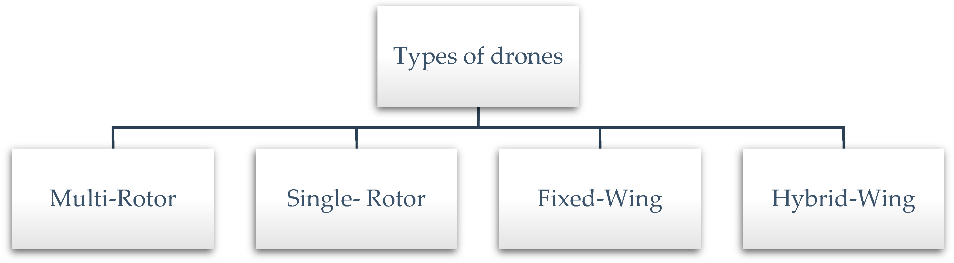
Among them, multi-rotor drones, also known as quadcopters, provide notable advantages over other UAV systems, including increased robustness, greater manoeuvrability, and lower acquisition and maintenance costs [11]. They are based on the principle of vertical take off and landing (VTOL) [12]. Multi-rotor drones feature more than two rotors and employ blades with a set pitch [11]. Additionally, because of their manoeuvrability, they can hover over a specific area, providing constant cellular coverage in specific locations, and can be operated via a variety of devices, including tablets, laptops, and desktop PCs [12]. Additionally, they can be easily equipped with sensors for light detection and ranging (LIDAR), cameras, and communication equipment [13]. As a result, numerous fields are expressing an increased interest in the use of multi-rotor drones for a variety of non-military reasons [14]. In terms of their mobility, it is extremely limited since they consume a significant amount of energy. Fixed-wing drones consume less energy than multi-rotor drones [15,16]. This is because they are capable of gliding and travelling at a high speed when carrying large payloads [12]. The primary disadvantage of fixed-wing drones is their need on runways for take off and landing, owing to their horizontal take off and landing (HTOL) nature. Additionally, their inability to hover over fixed areas, as well as their high-cost software/hardware, is a disadvantage [12]. Hybrid-wing drones were recently introduced fixed-/rotary-wing drones in the market. This type of drone combines the advantages of multi-rotor and fixed-wing drones, so it can reach its destination faster due to its ability to glide through the air. Meanwhile it has the ability to hover over a fixed location because of the usage of four rotors [12].
2.2. Australian Drone Regulations
Australia became the first country to regulate UAVs in early 2002 [17]. The Civil Aviation Safety Authority (CASA) is the primary government agency responsible for regulating the flight of UAVs in Australia. The Civil Aviation Safety Regulations Part 101 (Unmanned Aircraft and Rockets) Manual of Standards 2019 is the statutory instrument that governs the rules for UAVs.
Recreational users adhere to what is formally referred to as “standard operating conditions”, which are intended to safeguard both the operator and the surrounding community. They include flying only one unmanned aerial vehicle at a time and staying within visual line of sight (VLOS) [18]. Flights must stay below 120 m (400 feet) above ground level, no closer than 30 m to people, and never over or above people. Operators must avoid flying near emergency situations, in forbidden or restricted airspace, and within 5.5 km of a regulated aerodrome or airport. Recreational unmanned aerial vehicles (UAVs) are limited to a maximum weight of 2 kg [19].
Commercial users flying UAVs weighing less than 2 kg are permitted to operate under an excluded category providing they comply to established operating conditions, get an aviation reference number, and contact CASA prior to finishing the flight [18].
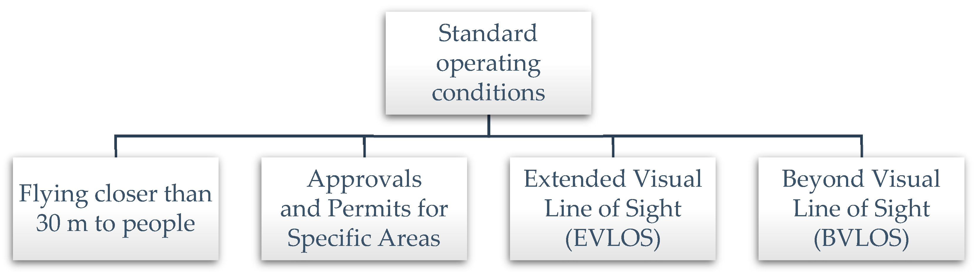
Commercial operators of UAVs weighing more than 2 kg must possess a remote pilot licence (RePL) and a remotely piloted aircraft operator’s certificate (ReOC), or be employed by a ReOC holder. Rocks and RePLs allow pilots to fly in situations that are not considered standard operating conditions, such as (Figure 2):
- Flying closer than 30 m to people [18]. Closer than 30 m but no closer than 15 m if the UAV has a twin parallel redundant battery system with duplicated battery mounting and is capable of flying with one motor inoperative at maximum take-off weight (MTOW). At least seven GNSS satellites must be operational for the Return Home function to be operational. A risk assessment must be conducted, with all identified risks suitably addressed, and all individuals within 30 m of the UAV must consent. Although written consent is preferable, it is not mandatory.
- Approvals and permits for specific areas [18]. Flying at a height of 120 m above ground level within a 5.5 km radius of controlled and uncontrolled airspace. Flying above or within 5.5 km of an airfield or movement area, both controlled and uncontrolled.
- Extended visual line of sight (EVLOS) [18]. Prior to application, a risk assessment must be conducted with all identified risks suitably addressed. All sections of the operational area must be constantly monitored by an observer. The pilot or observer must maintain a direct visual line of sight to the UAV at all times. To conduct EVLOS, both the pilot and observer must obtain authorisation from CASA.
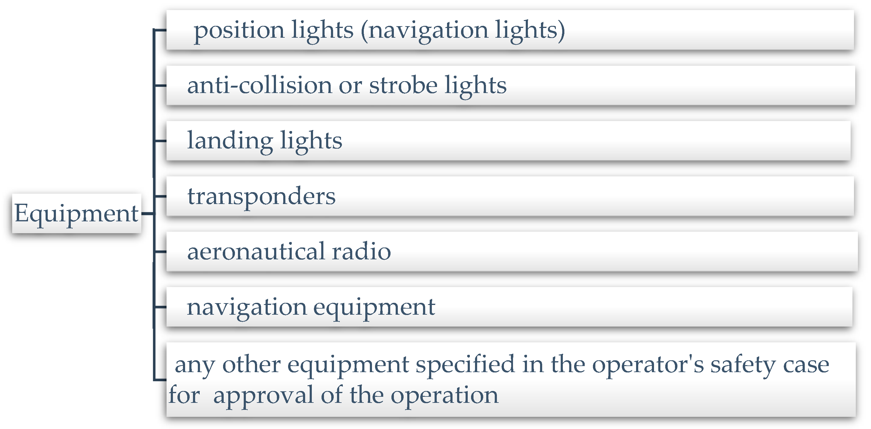
- Beyond visual line of sight (BVLOS). With the exception of BVLOS operations, this classification of flights is not routinely permitted. Extended visual line of sight (EVLOS) flight is a comparable operating category in which the remote pilot does not have direct visual sight of the remotely piloted aircraft (RPA) [20]. However, with the assistance of certified RPA observers (individuals who demonstrate proficiency in accordance with the operator’s approved training criteria), the remote pilot can still ensure the RPA’s safe operation [18]. Throughout these flights, at least one member of the remote crew will be able to see all portions of the intended operational airspace at all times. Physical impediments and weather circumstances should be considered in this assessment. Electronic aids, such as on-screen or moving-map displays and first-person perspective, may be utilised to assist the remote pilot in safely operating the aircraft, but they cannot replace direct eye contact [18]. BVLOS (including flight in non-visual meteorological circumstances) and EVLOS approvals are in addition to the regular ReOC privileges; however, they may be given by CASA [18]. To execute a BVLOS flight, the RePL holder who will fly the aircraft must possess a BVLOS flying licence. The applicant for this licence must pass at least one of the following exams: “an aeronautical knowledge examination for an instrument rating pursuant to Part 61; the former instrument theory examination (IREX) pursuant to Part 5 of the Civil Aviation Regulations 1988 (CAR); or an approved examination for this purpose”. Additionally, CASA requires operators to complete a case-by-case risk assessment and mitigation approach prior to submitting an application to operate BVLOS. Besides, the following equipment must be installed on the RPA and operable for BVLOS flight as shown in Figure 3. Furthermore, special clearance may be granted for flights over densely populated regions [18].
2.3. The UAV Industry Overview and Different Drone Applications in Australia
This section will review different drone applications from a global perspective as well as including applications and developments specific to Australia. It will be categorised into 11 industries, which includes agriculture, advanced air mobility, construction and infrastructure, energy, entertainment and media, insurance, mining, retail, real estate, security, and medical sectors.
2.3.1. Agriculture Sector for Drone Operation
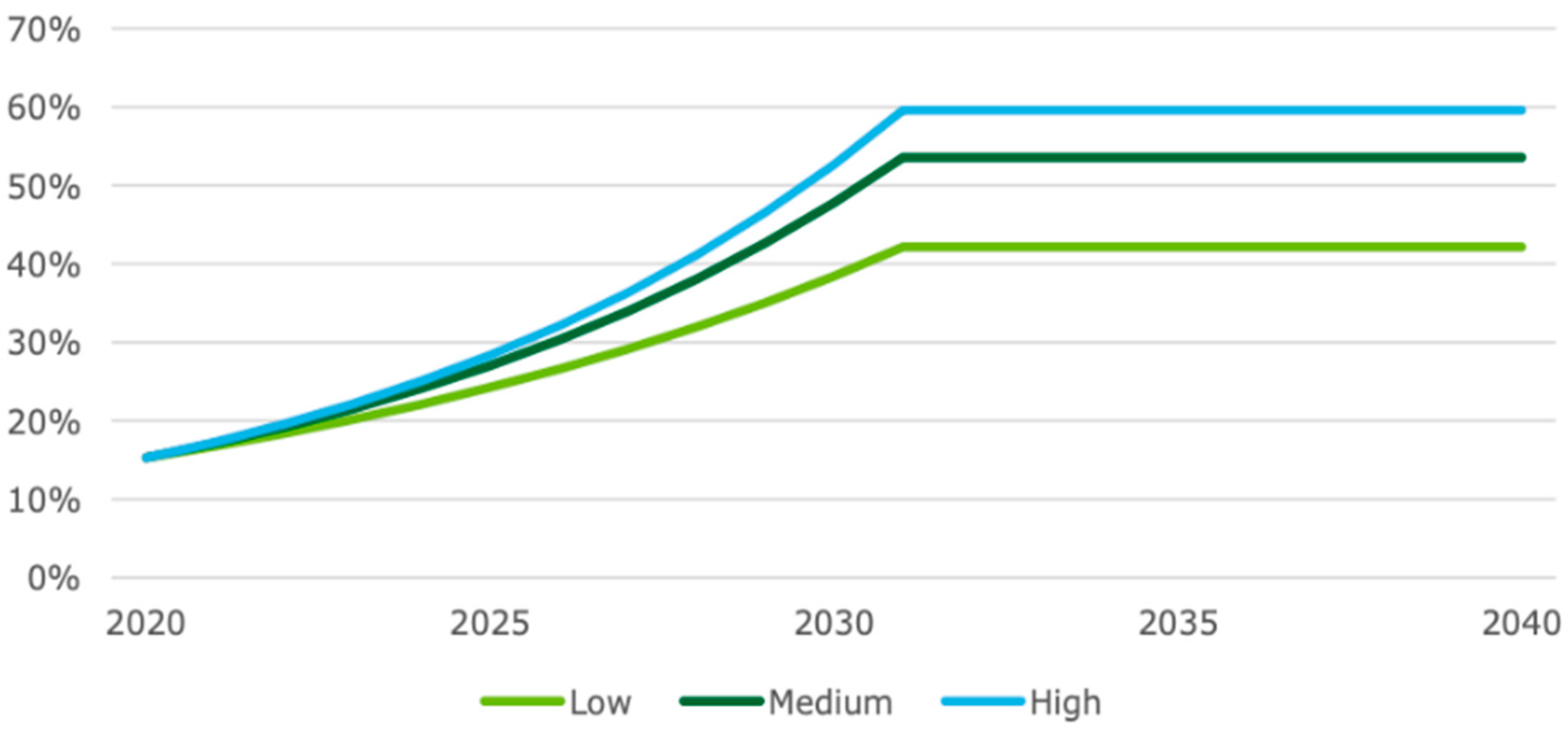
UAV technology has been used in agriculture to monitor pests and diseases, spot spray pesticides, spray fertilisers, identify crop damage, conserve natural resources, evaluate soil condition, and manage water use [21,22]. Logan [23] states that many companies in Australia are developing drones for the aim of monitoring crop health using infrared mapping (e.g., using the normalised difference vegetation index (NDVI)) in order to offer early warning of crop stress and crop health concerns on farmland. Zuo, Wheeler, and Sun [24] investigated 1000 farmers in Australia’s southern Murray–Darling basin. They found that just 4 to 8% of farmers in various agricultural businesses have used drone technology. However, up to one-third of farmers said they planned to utilise drones in the next five years, with application more likely to occur if irrigators can gain tangible benefits, for example, water and labour savings. According to DAE [25], drones are employed in agricultural enterprises for around 10% of the Australian agricultural market. ABS innovation data shows 1 in 10 agricultural, fishery and forestry firms developed a new or considerably enhanced operating process, and it also forecasts the future adoption rate of drones in agriculture. Figure 4 shows the increasing trends in the low, medium, and high uptake scenarios from 2020 to 2025.
2.3.2. Advanced Air Mobility Sector for Drone Operation
Advanced air mobility (AAM) is a new mode of air transportation for passengers and freight in metropolitan areas that employ electric vertical take-off and landing (eVTOL) aircraft [26]. Airport transfers and air taxis are examples of AAM vehicles that are suggested to provide on-demand or scheduled air transportation inside a metropolitan region to alleviate increasing surface congestion [26,27]. Currently, AAM vehicles are in the early phases of the technology lifecycle, with numerous organisations creating and prototyping, as well as demos and testing taking place throughout the world [25]. AAM will most likely remain as piloted aircraft, but as technology advances, limits are overcome, they will transition to fully autonomous vehicles. The highly concentrated population in metropolitan and regional centres is one of Australia’s advantages in developing AAM. Around 71 percent of Australians resided in large cities in 2016, with Sydney and Melbourne being the most densely inhabited areas in 2018 [28]. The Australian market is predicted to grow rapidly over the next 10 years, with eVTOL aircraft fleets becoming operational after 2030 [28]. Moreover, Creighton et al. suggest that informing the regulatory task, supporting efficient innovation, and developing the skill set necessary for optimal deployment and transition of AAM technologies requires a better knowledge of AAM technical and social issues in the Australian context. As a starting point, agreement on communication and information-sharing methods will be required [28].
2.3.3. Construction and Infrastructure Sector for Drone Operation
As an innovative technology, drones can facilitate construction tasks ranging from observation and inspection to monitoring of safe procedures, resulting in time, money, injury savings, and high-quality work [29]. Survey mapping, inspection, and job material tracking are areas where drones are used in the construction and engineering business [30]. Drones have made surveying safer, and the time it takes to do a survey has decreased from hours to minutes [30]. Drone mapping allows access to locations that would otherwise be unreachable on foot. Another example is bridge inspections. Drones can provide a safe approach for a bridge inspector to inspect different regions of a bridge [30]. The drones may stream live video from a camera to a monitor, giving the inspector access to real-time inspection data [30]. Drones can also be used to monitor project progress by taking aerial pictures in and out of construction sites [31]. Construction has historically been the fastest adopter of drones, ahead of mining and agriculture as it offers various uses in the sector which contribute to major efficiencies. An example is automating activities with the use of a drone or a drone fleet to improve project efficiency and worker safety [32].
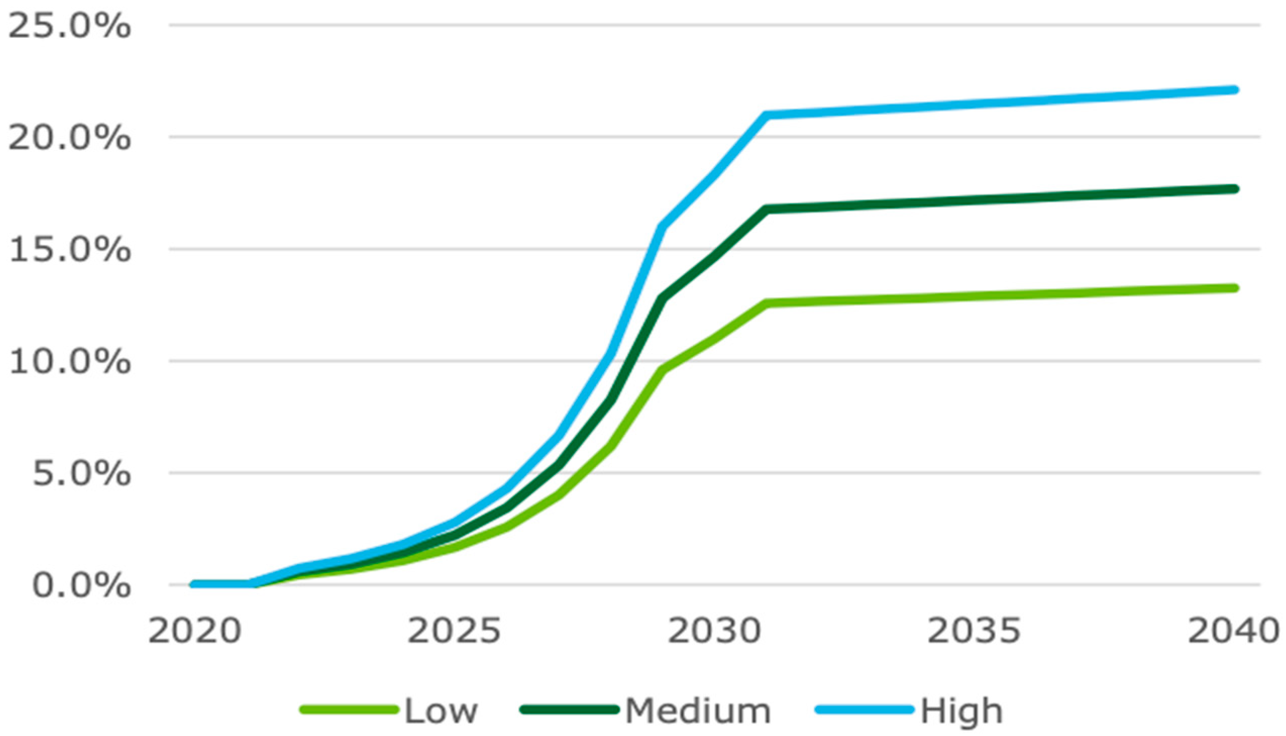
In Australia, drones are already being used in construction, allowing operators to survey, map, and give precise measurements. As a result, labour expenses are reduced, and site safety is improved [25]. In total, 15.5% of Australian construction companies have employed drones and received considerably enhanced operating procedures. The applications of drones in construction are expected to grow over the next five years in Australia, as illustrated in Figure 5.
2.3.4. Energy Sector for Drone Operation
Solar, wind, oil, and gas energy industries rely on inspections to maintain safety standards and successfully power the world, but those inspections can take a significant amount of time and money to complete [33]. Drones flying overhead utility facilities may instantly identify damage to everything from wind turbines to solar panels, avoiding potential problems before they grow. With the data obtained by a drone, abnormalities and damage may be rapidly identified, progress tracked, and orthomosaics, elevation data, and 3D maps can be made [33]. The market for drone inspections in the wind energy sector is driven by the vast number of blades that must be monitored for deterioration and damage on a regular basis. According to Vacca and Onishi (2017), the new untapped potential for drones can produce new forms of energy generation especially wind generation and solar power generation [34]. Rodrigues and others (2022) mentioned that drones can have up to 94% lower energy consumption per package than other vehicles [35]. According to Navigant Research, approximately 270,000 individual wind turbines were operational worldwide in 2015 [33]. Second, the lifespan of solar panels is contingent upon routine and efficient maintenance, and because solar farms span wide swaths of land, inspections can take considerable time and expenses. With a drone survey, inspection expenses can be halved, allowing businesses to boost efficiency and remain on top of operations maintenance [33]. Thirdly, the oil and gas business places a high premium on infrastructure inspection to ensure compliance with stringent government criteria. The industry is already utilising drones to detect damage, corrosion, and other potential maintenance issues on their sites. A drone can capture footage to create a georeferenced orthomosaic of complete gas plant sites, generate up-to-date timelines and high-resolution maps, and accomplish all of this in a matter of hours while maintaining operations and expenses [34]. Fourthly, pipes are another type of business that must be regularly inspected for leaks. A drone flying overhead pipelines can significantly reduce costs and inspection times. Additionally, a thermal camera can detect temperature variations between soil and fluid, allowing for the detection of oil and gas leaks. Finally, drones have the potential to significantly improve power line inspections at a lower cost and with less risk. A drone scan can swiftly locate storm damage or overgrown vegetation, allowing power to be restored as quickly as feasible [33].
UAVs have been utilised in the Australian energy industry for a variety of purposes, including remote monitoring and inspection, autonomous mapping and surveying, environmental and safety compliance, emergency response and surveillance, planning new developments, and upgrading infrastructure [36].
2.3.5. Entertainment and Media Sector for Drone Operation
In the film, television, and photography industries, drones can be used for a variety of tasks. They are now being used in almost every type of film project, from advertisements to shows to feature films and documentaries [37]. Drones have several advantages over traditional techniques of image capture. One advantage is that they are less expensive than planes or helicopters. A camera drone and operating crew, for example, can cost up to $20,000 per day less than a helicopter and crew, which is the typical means of shooting sweeping overhead pictures. Drones can also increase the quality of videos and images, especially now that technology has improved to the point where 4K cameras can be mounted on these machines. Drones can take shots at close range since they make little noise, allowing them to approach players without interrupting them during sporting events. They can also take images or films from unusual perspectives, as they can operate at a higher altitude than a crane but lower than a helicopter. Finally, they can reach isolated spots and take material that would otherwise be unavailable, such as filming birds in the highest branches of a tree for a wildlife documentary [38]. Drones can also be programmed to film high-speed pursuits, following the subjects through congested streets, mountainous highways, or any other location where another method would be problematic [39]. Additionally, drone racing has the potential to grow in popularity and is expected to expand similarly to eSports. The pleasure for participants comes from the pace, the combination of reality and a computer game. The attractiveness for spectators is mostly based on the magnificent scenery. Drone technology advancements should improve their agility and speed, making races more thrilling for a broader audience. Aerial photography is one of the most advanced forms of photography currently being used by the media and entertainment industry in Australia [38]. Television commercial drone photography is commonly used daily by news channels, and additionally, used in filming TV documentaries and movies [40].
2.3.6. Insurance Sector for Drone Operation
The introduction of drone technology has changed the insurance industry. Its advantages include faster claim process, better and more precise data collection, more precise risk management and pricing, and enhanced fraud prevention [41]. Drones speed the delivery of settlements to customers. A claims assessor outfitted with a drone may fly it around several insured areas to assess the danger or damage to a property with little to no individual risk, and there is no longer a need to climb ladders or climb to the top of rooftops to assess damage, as the drone can do it all [42]. Meanwhile, the exact photographs taken by drones have the potential to significantly enhance the quality of the claims adjudication process [42]. Drone-captured aerial imagery gives precise, up-to-the-minute visual data that can assist in quantifying any potential risk [42]. Drones are now being utilised in some circumstances to take photographs of a property before the issuance of an insurance. The precise photos that drones can offer, particularly those that obscure it (fence, storm shutters, etc.), aid in risk measurement and pricing. Insurance firms frequently get multiple claims following a severe occurrence for losses that existed prior to the incident. Insurers can take photos of covered premises and improve their ability to detect fraudulent claims by employing drones prior to a severe event [42].
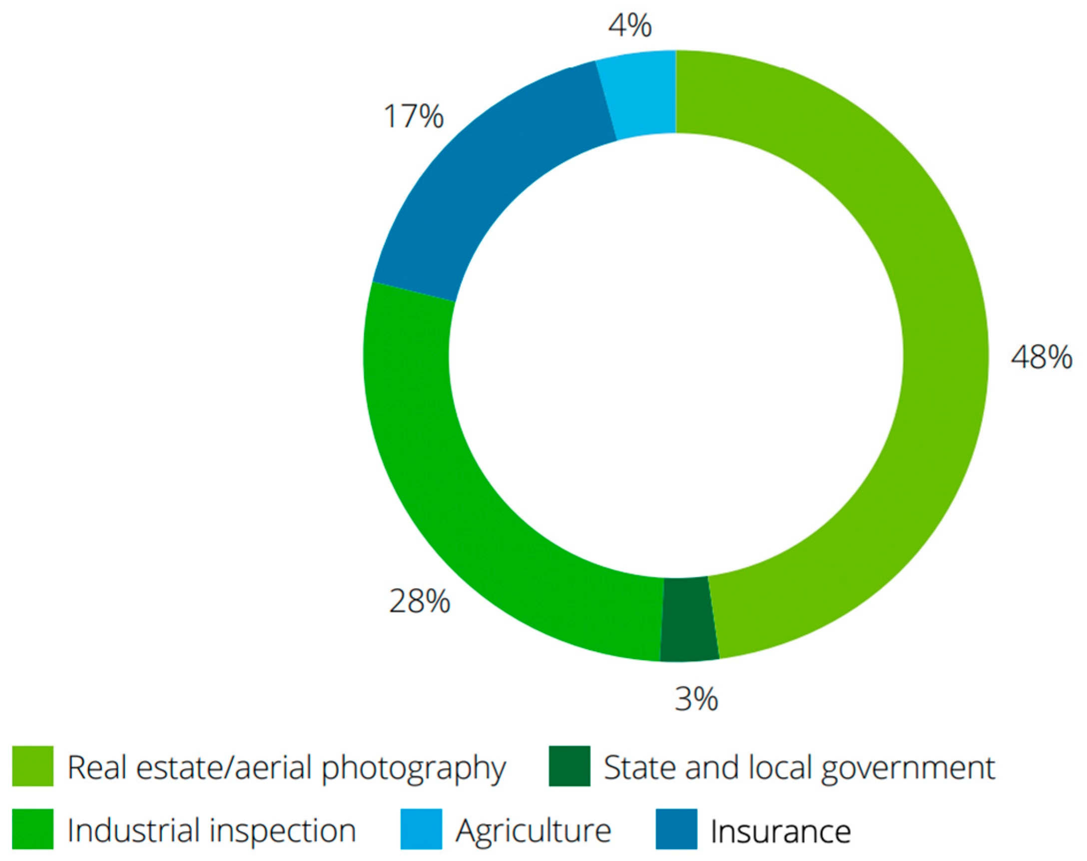
Figure 6 demonstrates the uses of commercial drones in the United States, with 17% of drones having been applied for commercial purposes in the insurance industry in 2018.
IAG, an Australian insurance firm, was the first to adopt drone technology to enhance its services. Implementing drones provides a prompt response to their clients following a natural disaster, such as a bushfire, and it provides a safer alternative to site inspection with a far faster turnaround [43].
2.3.7. Mining Sector for Drone Operation
Drones can be used in a variety of ways in the mining industry, resulting in enhanced productivity and safety [25]. As shown in Table 1, Lee and Choi [44] classified drone applications in the mining industry as surface, underground, and abandoned mines.
Shahmoradi et al. [45] claim that drones in mining operations have two major advantages. First, drones outfitted with various sensors can quickly check an area, either in an emergency or to identify hazards [45]. Secondly, drones can also be used for inspection and unblocking blocked box-holes and ore passages. In addition, drones can also be used to investigate blockages, explosives, and package transport [45].
Drones are already applied in Australia’s mining industry, allowing miners to monitor and inspect sites more efficiently, automate surveying and mapping, and manage stockpiles, roads, and dams [25]. Figure 7 shows the future trends of drone adoption in the mining industry in Australia, and the adoption rate is predicted to increase from around 15% to about 25% between 2020 and 2025 [25]. The primary constraint for further development is the requirement for qualified drone operators to use beyond visual line of sight (BVLOS) drones [25]. Although there are currently examples of BVLOS drones used for underground mining and autonomous ground vehicles used to map areas and aid emergency operations, wider acceptance is still possible [25]. Consequently, drones will be used more frequently in the future, resulting in significant benefits.
2.3.8. Retail Sector for Drone Operation
Khan et al. [46] argue that drone use is fast increasing, particularly in the retail business, due to the growing tendency of online ordering in congested cities. Many major retailers and logistics enterprises are pushing up their efforts to integrate drones into their systems in order to address the issue of “last mile” deliveries [46]. Drone delivery services allow retailers to offer extremely fast delivery times while lowering the cost of human labour. Dedicated aerial vehicles that fly directly from a delivery centre to the customer’s location help satisfy individual orders [47,48]. One of the primary advantages of drones in the urban logistic market is their ability to fly above traffic, thereby reducing road traffic and subsequently increasing safety, while also providing them with the competitive advantage of providing an extremely fast service between locations [49]. Moreover, the reach of local businesses selling food and beverages has expanded as well [50]. Whilst some UAVs are capable of transporting large cargo, those designed for urban areas have a limited shipment capacity up to 2.5 kg, with the flight limited to approximately 15 km with load. Amazon asserts that regarding e-commerce, 86% of packages weighed less than 5 pounds [51]. In terms of distance, Walmart claims that 70% of customers live within a 5-mile radius of a centre [51]. Notwithstanding this, it is important to note that from the perspective of integrating drone technology and economic activity, UAVs for small package deliveries are still at the concept validation stage [52,53]. Additionally, to safeguard all operations and the safety of all parties involved, the applicable country’s regulator responsible for flight operations should apply stringent flight safety requirements particularly for operations beyond visual line of sight (BVLOS) [48].
Wing, Alphabet’s drone delivery subsidiary, recently completed 100,000 deliveries [15]. Wing is currently operating in Australia, the United States of America, and Finland. Its greatest success has been in Logan, a suburb of Brisbane, Australia, where it has completed more than 50,000 of its total deliveries [54]. Logan has a population of approximately 300,000 people, and Wing’s service is accessible to about one-third of this population. The Wing “app” allows users to order a limited variety of things, such as coffee, groceries, sushi, cakes, pet food, and apparels. Deliveries are typically made in less than 10 min, and Wing’s delivery record is 2 min and 47 s from order to arrival [54]. A large part of Wing’s success appears to be due to its operations design. Wing’s drones are capable of flying as both fixed-wing aircraft and hovering copters. Unlike Amazon’s delivery drones, their aircraft do not require landing to carry products. Wing’s aircraft fly to their destination, descend at a height of 7 metres (23 feet), and then lower their parcels via a tether to the ground where they are automatically released [54]. Additionally, Wing’s operations in Logan highlight the effectiveness of CASA’s airspace regulation, which promotes innovation in unmanned aircraft delivery tactics [55]. Although the adoption rate in the retail sector is still under 5%, the drone delivery service is still recognised as a promising drone application in Australia as shown in Figure 8.
2.3.9. Real Estate Sector for Drone Operation
Aerial photography and videography are extremely effective tools, particularly in commercial real estate. Drones significantly improve the feasibility of acquiring this content. It outperforms satellite images in terms of quality and is significantly less expensive than deploying a manned plane or helicopter to take aerial imagery [55]. Aerial photography and video provide a more comprehensive view of a site for potential clients. People can obtain information that would be difficult to obtain otherwise, such as how traffic generally moves into and out of the area [55]. Drones can be used for commercial real estate inspections, performing entire baseline work, and performing routine checks during the property’s life. Along with photography and videography equipment, UAVs can be equipped with a variety of sensors, such as thermal sensors, which determine whether a building’s hot or cold air is exiting, allowing the operators to optimise its heating and cooling efficiency. Furthermore, this thermal testing device can be used to detect damaged building infrastructure and pooling water beneath a flat roof [55]. Besides, UAVs can conduct examinations much more efficiently than humans, as all that is required for the UAV to fly over the building is to be equipped with the essential sensors. Using a UAV avoids the hazard associated with having an inspector climb onto a building’s roof. Drones can be used to inspect for damage following a storm or other natural disaster. These situations can be hazardous for inspectors, making an unmanned inspection the prudent alternative. Combining unmanned aerial vehicles with other modern technologies such as artificial intelligence may increase their use. Machine learning techniques can sift through drone imagery and assist in identifying anomalies that require further examination. This can significantly improve a commercial property’s overall security and potentially extend its life [55].
Commercial aerial drone photography is gaining popularity in a variety of businesses around Australia as part of their marketing objectives because it enables businesses to maximise their real estate marketing approaches and attract new clients by presenting a property in a truly unique and niche manner [56]. Drone applications in real estate include product and service marketing, aerial photography, drone virtual tours, perspective on large scale spaces, commercial property promotion, and residential and industrial [56].
2.3.10. Security Sector for Drone Operation
Aerial drone services are an ideal tool for improving security [57]. Drones can illuminate blind spots and penetrate previously inaccessible areas [58]. Visibility is enhanced by high-quality cameras on the drone capturing details often ignored by conventional systems. In the long run, drones decrease operational costs and manual effort [58]. In the interim, they assist in mitigating danger and increasing the efficiency of security personnel [58]. This includes intruder detection, event surveillance, anti-poaching, traffic management, perimeter guarding, and border patrol [58]. Drones can be used to detect intruders and respond to alarms triggered by sensors. It can assist security operators during events, such as rallies. Drones can provide real-time site data with live and continuous HD video surveillance feed. Forestry officials can monitor broad areas of the landscape to identify poachers and monitor animal populations. For traffic and accident control, police officers can use automatic smart features such as licence plate recognition and vehicle count. Lastly, security forces can monitor high-risk zones such as borders in real time in order to provide comprehensive situational awareness and remote decision-making.
2.4. Medical Drone Services in Australia
A group of academics in Australia collaborated with Dragonfly to create drones capable of identifying COVID-19 symptoms and infectious illnesses by detecting/testing body temperatures using artificial intelligence [8]. The drones can detect symptoms from 10 m away and send the information to the operator in real-time. The aim is to monitor and trace the disease as quickly as possible in order to confine and minimise human-to-human contact [59]. The drone’s sensors can track body temperature, heart rate, respiration rate, and other abnormalities. These measurements are collected in different locations, particularly in crowded places. The technology designed for epidemic and catastrophe control can potentially save lives and it is currently being deployed across a vast domain [60]. In addition, Swoop Aero, an Australian drone service provider, uses contact-free air logistics that are vital in carrying PPE, vaccinations, and COVID-19 testing kits to health-care centres, of which the samples are then transferred back to laboratories for testing around the globe [61].
3. Methods
3.1. Research Method
This research used a mixed-methods approach, including both quantitative and qualitative methods [62]. Both methods are essential in attaining the research goals and compensating for the other approach’s flaws to increase the quality of the research outcomes [63]. This research adopted an online questionnaire to gather data from the Australian UAV industry, which included Likert scale and open-end questions. Interval-based Likert scales with values ranging from 1 (Strongly disagree) to 5 (Strongly agree) were used to collect data. The open-ended questions are used to better understand participants’ thoughts, as they allow participants to express their perspectives comprehensively. The sampling strategy used in this study is convenience sampling. A sample size of 30 will create a sampling distribution for the sample mean from a non-normal parent distribution that is nearly normal. Therefore, this research collected 36 valid responses.
To reinforce the survey results, Arena simulation was employed in this study to simulate the use of drones in medical delivery scenarios. Based on the research questions and objectives, it was crucial to assess the suitability of different drone types for medical services in Australia. Therefore, the simulation aimed to assess whether the use of drones can enhance the efficiency of the medical delivery system in Australia, and the most suitable drone type for this purpose was identified through the simulation. By simulating the delivering times of different drone types on a sample route in this scenario, the study quantitatively analysed the performance of each drone.
Simulation is an effective approach to replicate real-word systems and predict their performance by using real-word information and data [64]. In addition, since the simulation conducted in this study involved transport processes, Arena simulation was selected as the most appropriate tool to model the process and generate reliable data. Moreover, as Arena enables a large amount of replicated experiments to be conducted within a short time, the simulation results were both precise and dependable.
3.2. Data Collection
The online questionnaire was administered via Qualtrics, an online surveying platform. Quantitative data can be translated to numerical data, which can then be used to provide useful information using statistics. The respondents responded to questionnaire questions by selecting from a list of options. The online questionnaire was restricted to those who worked in the UAV sector and resided in Australia.
To ensure the accuracy of the simulation, the parameters of each drone were collected from the manufacturer’s official website, while the sample route data were gathered from Google Maps.
3.3. Research Limitations
There are several limitations in this research. The first is the sample size of only 36 participants. The second is the limited references available for drone applications in the Australian UAV industry. Thirdly, this research did not comprehensively discuss drone technology, but the focus is on drones’ applications for different commercial operations.
4. Findings
After applying the proposed research method and gathering the questionnaire results, the following findings were generated. In sort, demographic data of the participants is presented first, followed by descriptive analysis of the questionnaire results relative to the main two research questions.
4.1. Demographic Data
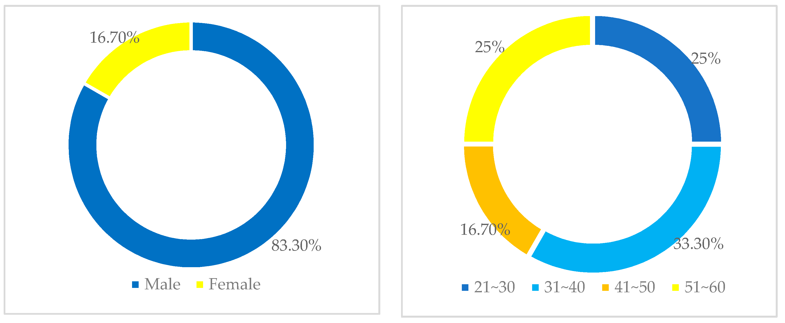
The demographics of the participants were collected via 5 questions, as shown in Figure 9 and Figure 10 below. They were asked to indicate their gender, age, working experience, whether they have a remote pilot license, as well as the organisation they worked in. Out of the 36 participants, there were 30 males (83.3%) and 6 females (16.7%).
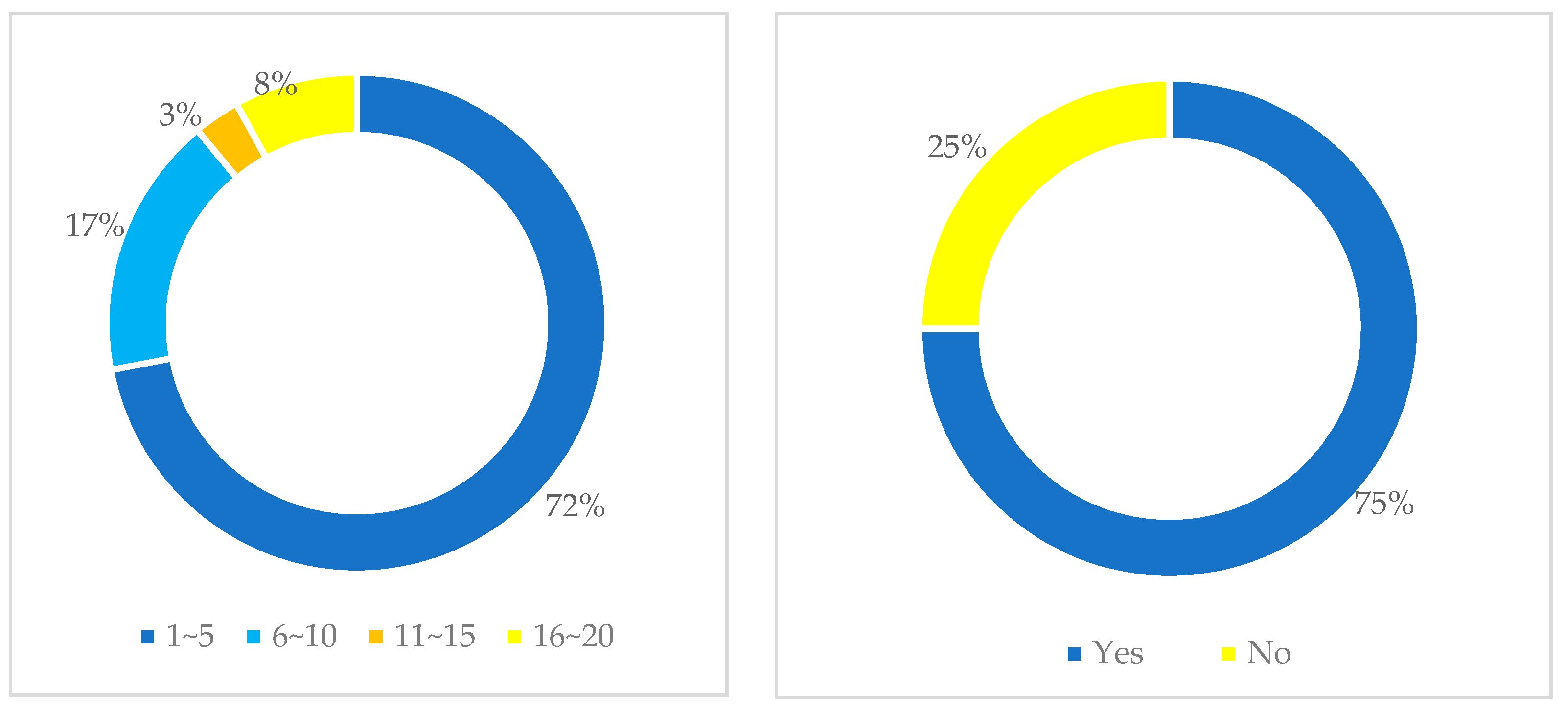
In total, 72% of participants have 1 to 5 years work experience in the UAV sector; 17% have 6 to 10 years; 8% have 16 to 20 years; and 3% of participants have 11 to 15 years working experience. Additionally, 27 participants (75%) also have a remote pilot licence RePL (Figure 10).
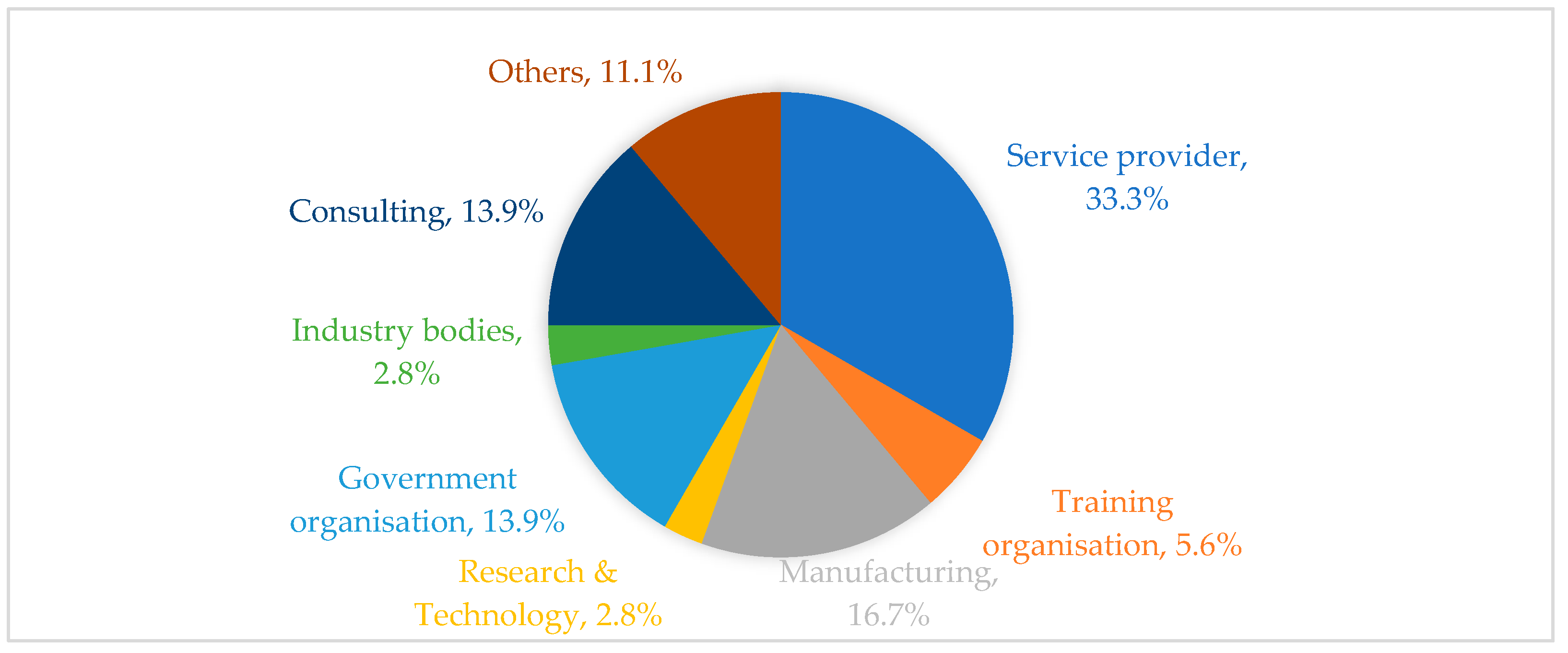
Figure 11 shows the organisation type those participants worked in. There were 33% of participants from drone service providers; 16.7% of participants from manufacturing; 13.9% of participants from consulting companies; 13.9% of participants from government organisations; 5.6% of participants from training organisations; 2.8% of participants from industry bodies; and 2.8% of participants from the research and technology fields.
4.2. The Performance Simulation Using Drones in Medical Transportation
According to Rosser [65], medical delivery is one of the most common applications of drones. As shown in Table 2, 4 types of drones can be used in medical service, which are hybrid-wing drones, fixed-wing drones, multi-rotor drones, and single-rotor drones. Therefore, a hypothesis was proposed accordingly: the use of UAVs can improve the efficiency of medical delivery systems, with hybrid-wing drones showing the most outstanding performance.
In this paper, the performance of the four types of drones in the medical transport scenario was simulated. The selected sample drones for simulation were the FDG410 (Fly Dragon) for the hybrid-wing drone [66], THE FALK (MARITIME ROBOTICS) for the fixed-wing drone [67], MATRICE 600 (DJI) for the multi-rotor drone [68], and PDH-GS120 (PRODRONE) for the single-rotor drone [69]. The parameters of these samples were collected from the official website of each drone manufacturer.
A sample route in a suburb area of Australia was chosen in this simulation, which was from Broadmeadows Hospital, VIC to The Homestead Community and Learning Centre, VIC. The straight-line flight distance of this route is 5.7 km. In the simulation, the speed of each drone was set based on the cruising speed and the wind resistance speed.
To test the relationship between drone types and their efficiency for medical delivery, a simulation was conducted to measure the transport times of delivering medicine along the sample route for each drone type. The sample drones used in the simulation were chosen to represent the main features of each drone type and to gather data to support the simulation. It should be noted that the results obtained from this simulation can be applied to other drones, as the main features of drones in each type are generally similar between different brands.
Simulation assumption:
To ensure the accuracy and reliability of the simulation results, some assumptions were proposed during the simulation.
1. To standardize the selected drone samples in terms of size and usage, the drones used in the simulation were selected based on their maximum payload, which was limited from 6 kg to 15 kg.
2. A consistent payload of 6 kg was used for all drones in the simulation.
3. To make the results more realistic, the effect of wind on flight speed was random in the simulation.
4. The distance and transport time of the land vehicle were estimated based on the real-time and historical data obtained from Google Maps.
5. To further ensure the reliability of the result, a total of 11,321 times of delivery activities were simulated (Appendix A).
In Appendix A, it is evident that all types of drones outperformed the land vehicle in medical delivery. The transport time of the land vehicle is affected by both the traffic volume and the route situation, introducing uncertainties in the process. The simulation results demonstrated that as the difference between the land vehicle’s minimum and maximum transport times was the most significant compared to the drones, the use of UAVs can improve the efficiency of medical delivery systems. The hybrid-wing drone performed best in the simulation, with the smallest difference between its minimum and maximum transport times, indicating its stable performance. The fixed-wing drone ranked second, with a transport time close to that of the hybrid-wing drone. In addition, the single-rotor and multi-rotor drones ranked third and fourth, respectively. The results support that hybrid-wing and fixed-wing drones have faster speeds than single-rotor and multi-rotor drones, and the wind resistance ability of drones is deeply affected by the types of wings. However, in medical services, delivery time is a crucial standard for evaluating a drone’s performance. Therefore, hybrid-wing and fixed-wing drones are more suitable for this scenario.
As shown in the table, both hybrid-wing and fixed-wing drones showed similar performance. However, fixed-wing drones require a launcher or runway for takeoff and landing, and they can only move forward and are unable to hover in the air, which makes this type of drones less suitable for medical delivery. On the other hand, hybrid-wing drones are an improvement over traditional fixed-wing drones, as they can overcome the limitations of fixed-wing drones mentioned above. Therefore, the hybrid-wing drones are the most suitable option for medical delivery systems, thereby verifying the hypothesis.
5. Discussion
1. What types of UAV services should Australian UAV service providers focus on for the future?
Around 52.8% of participants strongly agreed or agreed that the COVID-19 pandemic could bring positive impacts on the Australian UAV industry. According to Table 2, drone applications in the construction, agriculture, energy, mining, entertainment, real estate sectors would have more flights. As these applications are progressively utilised, the technology being used in these sectors also develops concurrently and has high maturity. Drones in the construction sector are predicted to have the most significant number of flights in Australia in the next five years. Conversely, drone applications in the insurance, medical, retail, security, and air mobility sectors have a lower mean value than the total mean. This is in part due to drone applications in these industries requiring beyond visual line of sight (BVLOS) capabilities. For example, medical drone services and retail services require long-distance and range. The approval for BVLOS flights applies to a wide and varied number of commercial uses such as border patrols and long-distance inspections. However, the local regulator, CASA, only released a draft guidance for RPAS BVLOS operations in 2021, which means the rules of BVLOS are still at the initial stage [18,19].
Furthermore, advanced air mobility is for transporting passengers, and it requires further testing and research to ensure a safe operation. Not only is autonomous flight capability critical for BVLOS operations for UAS, but it is also likely to have a substantial impact on the future development of autonomous passenger aircraft. Eliminating the human factor in an aircraft flight operation has always been a primary safety objective as well as a potential source of cost savings. Thus, it appears that the benefits of BVLOS capabilities outweigh the risks currently associated with a UAS flying outside an operator’s line of sight.
According to the above argument, the Australian service providers should focus on drone applications in the construction, agriculture, energy, mining, entertainment, and real estate sectors for the next five years.
2. What is the future trend of UAV medical services in Australia?
In total, 50% of participants strongly agreed or agreed that the medical drone services would increase for the next 5 years due to the epidemic. Currently, only 8.3% of participant’s firms provide medical drone services. This is because of the unique nature of the contents delivered. Medical supply distribution through UAV is a special application field. Medical equipment, instruments, and medications are frequently subject to more stringent standards than general-purpose items available from stores such as pharmacies. Certain medications (e.g., pharmaceuticals) require additional protection or storage conditions such as vaccines. Due to the need for extra protection and special storage requirements for medical supply delivery, it has a higher entry cost than other applications. Furthermore, Figure 10 highlights some challenges for developing a medical drone service. Appendix A shows that drone application for medical purposes only has a mean of 7.17, which is far higher than the total mean of 5.96. This figure suggests that medical drone service may not increase as much as the construction sector. The government will need to establish a robust BVLOS operation and airspace management to facilitate the future development of medical drone services. The simulation results demonstrated that the hybrid-wing drone performed best in the simulation, the fixed-wing drone ranked second, the single-rotor and multi-rotor drones ranked third and fourth, respectively.
6. Conclusions
This research has highlighted that drones and their associated technologies can be utilised in many industries such as construction, agriculture, energy, and so forth in an increasing scope and in applications not previously explored prior to the COVID-19 pandemic. Operations and tasks that were previously considered impossible for the human operator to practically perform in a safe or cost-effective way have been shown to be possible by the use of drones. In particular, the construction, agriculture, energy, and entertainment industries have higher potential growth for the Australian drone market. Most participants believe that the medical drone service would be increasing their number of flights due to their ability to provide contactless services to minimise the risks of the virus spreading. However, drone applications in the health care and medical fields are highly dependent on BVLOS regulations and airspace management changes. Therefore, these challenges need to be addressed to facilitate the development of medical drone services. Moreover, the simulation results demonstrated that the hybrid-wing drone performed best in the simulation, the fixed-wing drone ranked second, the single-rotor and multi-rotor drones ranked third and fourth, respectively.
7. Recommendations and Future Research
Although this research used quantitative and qualitative data to analyse the future trends of Australian drone applications, the qualitative data could also consider the interview as a primary tool to collect qualitative data to acquire a more insightful perspective. This could collect more information about how drones are being used in different sectors and overcome some challenges in the regulatory system. Moreover, the interview could reveal what type of drones are being used in a specific type of service. Additionally, to gather more participants to validate the research result further, the researcher could consider collaborating with CASA or Australian Association for Unmanned Systems (AAUS) to reach more people who worked in the UAV industry. Finally, there is little research on some drone applications, such as insurance, security, and the real estate industry, as stated in the research limitation. As a result, further research could explain some challenges within these fields and provide potential solutions to foster the future development of drone applications in Australia.
Author Contributions
Conceptualization, I.H. and Y.-W.K.; methodology, I.H. and Y.-W.K.; validation, I.H., Y.-W.K., J.L., R.C.K.Y. and W.V.; formal analysis, I.H., Y.-W.K., R.C.K.Y. and W.V.; investigation, Y.-W.K.; resources, Y.-W.K.; data curation, I.H., Y.-W.K. and J.L.; writing—original draft preparation, Y.-W.K.; writing—review and editing, I.H., Y.-W.K., J.L., R.C.K.Y. and W.V.; visualization, I.H. and Y.-W.K.; supervision, I.H.; project administration, I.H. All authors have read and agreed to the published version of the manuscript.
Funding
This research received no external funding.
Data Availability Statement
Data sharing not applicable. No new data were created or analysed in this study. Data sharing is not applicable to this article.
Conflicts of Interest
The authors declare no conflict of interest.
Abbreviation
| AAM | advanced air mobility |
| AI | artificial intelligence |
| BVLOS | beyond visual line of sight |
| CASA | Civil Aviation Safety Authority |
| eVTOL | electric vertical take-off and landing aircraft |
| EVLOS | extended visual line of sight |
| HTOL | horizontal take-off and landing |
| IAG | Australian Insurance Group |
| IREX | instrument theory examination |
| LIDAR | light detection and ranging |
| MTOW | maximum take-off weight |
| NDVI | normalised difference vegetation index |
| PPE | personal protective equipment |
| ReOC | remotely piloted aircraft operator’s certificate |
| RePL | remote pilot licence |
| RPA | remotely piloted aircraft |
| RPAS | remotely piloted aerial system |
| UAVs | unmanned aerial vehicles |
| UAS | unmanned aerial system |
| VTOL | vertical take-off and landing |
| VLOS | staying within visual line of sight |
Appendix A. Simulation Result

References
- Cracknell, A.P. UAVs: Regulations and law enforcement. Int. J. Remote Sens. 2017, 38, 3054–3067. [Google Scholar] [CrossRef]
- Ren, H.; Zhao, Y.; Xiao, W.; Hu, Z. A review of UAV monitoring in mining areas: Current status and future perspectives. Int. J. Coal Sci. Technol. 2019, 6, 320–333. [Google Scholar] [CrossRef] [Green Version]
- Wong, K.C.; Bill, C. UAVs over Australia-market and capabilities. In Proceedings of the 13th Bristol International Conference on RPVs/UAVs, Bristol, UK, 13–18 September 1998. [Google Scholar]
- Ghasri, M.; Maghrebi, M. Factors affecting unmanned aerial vehicles’ safety: A post-occurrence exploratory data analysis of drones’ accidents and incidents in Australia. Saf. Sci. 2021, 139, 105273. [Google Scholar] [CrossRef]
- Ghazzai, H.; Menouar, H.; Kadri, A.; Massoud, Y. Future UAV-Based ITS: A Comprehensive Scheduling Framework. IEEE Access 2019, 7, 75678–75695. [Google Scholar] [CrossRef]
- Kovalev, I.V.; Voroshilova, A.A.; Karaseva, M.V. Analysis of the current situation and development trend of the international cargo UAVs market’. J. Phys. Conf. Ser. 2019, 1399, 55095. [Google Scholar] [CrossRef] [Green Version]
- Saraf, V.; Senapati, L.; Swarnkar, T. Application and progress of drone technology in the COVID-19 pandemic: A comprehensive review. In Computational Modeling and Data Analysis in COVID-19 Research; eBook: Boca Ration, FL, USA, 2021; pp. 47–66. [Google Scholar]
- Butt, U.J.; Richardson, W.; Abbod, M.; Agbo, H.-M.; Eghan, C. The Deployment of Autonomous Drones during the COVID-19 Pandemic. In Cybersecurity, Privacy and Freedom Protection in the Connected World, Advanced Sciences and Technologies for Security Applications; Springer International Publishing: Berlin, Germany, 2021; pp. 183–220. [Google Scholar]
- Van Veelen, M.J.; Kaufmann, M.; Brugger, H.; Strapazzon, G. Drone delivery of AED’s and personal protective equipment in the era of SARS-CoV-2. Resuscitation 2020, 152, 1–2. [Google Scholar] [CrossRef]
- Types of Drones: Multi-Rotor vs. Fixed-Wing vs Single Rotor vs. Hybrid VTOL, Australia UAV. Available online: https://www.auav.com.au/articles/drone-types/ (accessed on 12 October 2021).
- Li, Y.; Liu, C. Applications of multirotor drone technologies in construction management. Int. J. Constr. Manag. 2019, 19, 401–412. [Google Scholar] [CrossRef]
- Yaacoub, J.P.; Noura, H.; Salman, O.; Chehab, A. Security analysis of drones systems: Attacks, limitations, and recommendations. Internet Things 2020, 11, 100218. [Google Scholar] [CrossRef]
- Harvey, M.C.; Rowland, J.V.; Luketina, K.M. Drone with thermal infrared camera provides high resolution georeferenced imagery of the Waikite geothermal area, New Zealand. J. Volcanol. Geotherm. Res. 2016, 325, 61–69. [Google Scholar] [CrossRef]
- Irizarry, J.; Costa, D.B. Exploratory Study of Potential Applications of Unmanned Aerial Systems for Construction Management Tasks. J. Manag. Eng. 2016, 32, 5016001. [Google Scholar] [CrossRef]
- Vincent, P.J.; Tummala, M.; McEachen, J. An energy-efficient approach for information transfer from distributed wireless sensor systems. In Proceedings of the 2006 IEEE/SMC International Conference on System of Systems Engineering, Los Angeles, CA, USA, 26–28 April 2006; IEEE: New York, NY, USA, 2006. [Google Scholar]
- Uragun, B. Energy efficiency for unmanned aerial vehicles. In Proceedings of the 2011 10th International Conference on Machine Learning and Applications and Workshops, Honolulu, HI, USA, 18–21 December 2011; IEEE: New York, NY, USA, 2011. [Google Scholar]
- Regulation of Drones: Australia, Library of Congress. Available online: https://www.loc.gov/law/help/regulation-of-drones/australia.php (accessed on 12 October 2021).
- Civil Aviation Safety Authority 2021, Draft Guidance for RPAS BVLOS Operations, Civil Aviation Safety Authority. Available online: https://consultation.casa.gov.au/regulatory-program/bvlos-app/ (accessed on 12 October 2021).
- Drone Safety Rules, Civil Aviation Safety Authority. Civil Aviation Safety Authority 2021. Available online: https://www.casa.gov.au/drones/rules/drone-safety-rules (accessed on 8 October 2021).
- Bradley, H.L. Identifying Opportunities Available through Utilization of Unmanned Aerial Delivery Programs in Support of Public Safety in the United States, Based on Present Use Cases Around the World. Available online: http://purl.flvc.org/fsu/fd/FSU_libsubv1_scholarship_submission_1587494473_43a93295 (accessed on 12 October 2021).
- Push Button Agriculture: Robotics, Drones, Satellite-Guided Soil and Crop Management, Routledge & CRC Press. Available online: https://www.routledge.com/Push-Button-Agriculture-Robotics-Drones-Satellite-Guided-Soil-and-Crop/Krishna/p/book/9781774635964 (accessed on 16 October 2021).
- Urbahs, A.; Jonaite, I. Features of the use of unmanned aerial vehicles for agriculture applications. Aviation 2013, 17, 170–175. [Google Scholar] [CrossRef]
- Drone Mapping in Agriculture on the Rise, Australian Broadcasting Corporation. Available online: https://www.abc.net.au/news/rural/2017-03-07/drone-use-increasing-for-ndvi-mapping/8328456 (accessed on 1 October 2021).
- Zuo, A.; Wheeler, S.A.; Sun, H. Flying over the farm: Understanding drone adoption by Australian irrigators. Precis. Agric. 2021, 22. [Google Scholar] [CrossRef]
- Economic Benefit Analysis of Drone in Australia Final Report, Deloitte Access Economics. Available online: https://www.infrastructure.gov.au/aviation/technology/files/economic-benefit-analysis-of-drones-to-australia-final-report.pdf (accessed on 2 August 2021).
- Murça, M.C.R. Identification and prediction of urban airspace availability for emerging air mobility operations. Transp. Res. Part C Emerg. Technol. 2021, 131, 103274. [Google Scholar] [CrossRef]
- Goyal, R.; Reiche, C.; Fernando, C.; Cohen, A. Advanced Air Mobility: Demand Analysis and Market Potential of the Airport Shuttle and Air Taxi Markets. Sustainability 2021, 13, 7421. [Google Scholar] [CrossRef]
- Advanced Aerial Mobility and eVTOL Aircraft in Australia: Promise and Challenges, Deakin University. Available online: https://www.deakin.edu.au/__data/assets/pdf_file/0010/2213794/Deakin-University-Mobility-Whitepaper-Advanced-Aerial-Mobility-and-eVTOL-aircraft-in-Australia.pdf (accessed on 15 October 2021).
- Herrmann, M. Unmanned aerial vehicles in construction: An overview of current and proposed rules. In Proceedings of the Construction Research Congress 2016, Reston, VA, USA, 31 May–2 June 2016; pp. 588–596. [Google Scholar]
- Sanson, J. Drone Use in the Construction Industry Leads to Integration into the Current Civil and Construction Engineering Technology Curriculum. In Proceedings of the CIEC, New Orleans, LA, USA, 1–3 February 2019. [Google Scholar]
- Yahya, M.Y.; Shun, W.P.; Yassin, A.M.; Omar, R. The Challenges of Drone Application in the Construction Industry. J. Technol. Manag. Bus. 2021, 8, 20–27. [Google Scholar] [CrossRef]
- The Rise of Drones in Construction, DroneDeploy. Available online: https://www.dronedeploy.com/blog/rise-drones-construction/ (accessed on 6 October 2021).
- How Drones Are Revolutionizing the Energy Industry, DrDrone. Available online: https://www.drdrone.ca/blogs/drone-news-drone-help-blog/howdronesarerevolutionizingtheenergyindustry (accessed on 2 October 2021).
- Energy & Infrastructure, Carbonix. Available online: https://carbonix.com.au/industry-solutions/energy-infrastructure/ (accessed on 10 October 2021).
- Vacca, A.; Onishi, H. Drones: Military weapons, surveillance or mapping tools for environmental monitoring? The need for legal framework is required. Transp. Res. Procedia 2017, 25, 51–62. [Google Scholar] [CrossRef]
- Rodrigues, T.A.; Patrikar, J.; Oliveira, N.L.; Matthews, H.S.; Scherer, S.; Samaras, C. Drone flight data reveal energy and greenhouse gas emissions savings for very small package delivery. Patterns 2022, 3, 100569. [Google Scholar] [CrossRef]
- The Future of Drones in the Entertainment Industry, Insuremydrone. Available online: https://insuremydrone.net/drone-insurance-future/ (accessed on 6 October 2021).
- Media and Entertainment, XM2. Available online: http://xm2.com/industrial/index.php/media-and-entertainment/ (accessed on 3 October 2021).
- United Rotorcraft 2020, How Drones Are Changing the Entertainment Industry, United Rotorcraft. Available online: https://www.unitedrotorcraft.com/newsroom/how-drones-are-changing-the-entertainment-industry/ (accessed on 3 October 2021).
- Aerial TV & Film Photography Adelaide, Adelaide Arial. Available online: https://www.adelaideaerial.com/aerial_tv_film_photography_adelaide (accessed on 4 October 2021).
- How Drone Technology Is Impacting the Insurance Industry, Resilium. Available online: https://www.resilium.com.au/how-drone-technology-is-impacting-the-insurance-industry/ (accessed on 4 October 2021).
- Insurance Industry Drone Use Is Flying Higher and Farther, DAE. Available online: https://www2.deloitte.com/us/en/pages/financial-services/articles/infocus-drone-use-by-insurance-industry-flying-higher-farther.html (accessed on 8 October 2021).
- Insurance Business Australia 2016, Insurance Drones Have Lift Off, Insurance Business Australia. Available online: https://www.insurancebusinessmag.com/au/features/analysis/insurance-drones-have-lift-off-58518.aspx (accessed on 1 October 2021).
- Lee, S.; Choi, Y. Reviews of Unmanned Aerial Vehicle (Drone) Technology Trends and Its Applications in the Mining Industry. Geosystem Eng. 2016, 19, 197–204. [Google Scholar] [CrossRef]
- Shahmoradi, J.; Talebi, E.; Roghanchi, P.; Hassanalian, M. A Comprehensive Review of Applications of Drone Technology in the Mining Industry. Drones 2020, 4, 34. [Google Scholar] [CrossRef]
- Asghar, K.M.; Safi, E.A.; Khan, U.I.; Alvi, A.B. Drones for Good in Smart Cities: A Review. In Proceedings of the International Conference on Electrical, Electronics, Computers, Communication, Mechanical and Computing (EECCMC), Bhubaneswar, India, 28–29 January 2018. Project: UAVs assisted ad hoc network for Smart Cities 2018. [Google Scholar]
- The Economics of Drone Delivery, IEEE Spectrum. Available online: https://spectrum.ieee.org/the-economics-of-drone-delivery#toggle-gdpr (accessed on 1 October 2021).
- Perera, S.; Dawande, M.; Janakiraman, G.; Mookerjee, V. Retail Deliveries by Drones: How Will Logistics Networks Change? Prod. Oper. Manag. 2020, 29, 2019–2034. [Google Scholar] [CrossRef]
- Roca-Riu, M.; Menendez, M. Logistic deliveries with drones: State of the art of practice and research. In Proceedings of the 19th Swiss Transport Research Conference (STRC 2019), Ascona, Switzerland, 15–17 May 2019. [Google Scholar]
- Bass, J. Leveraging Drones for Delivery: Our Vision to Improve Safety, the Environment, and Customer Service. In Proceedings of the Transportation Research Board 98th Annual Meeting, Washington, DC, USA, 13–17 January 2019. [Google Scholar]
- Amazon’s Jeff Bezos Looks to the Future, CBS News. Available online: https://www.cbsnews.com/news/amazons-jeff-bezos-looks-to-the-future/ (accessed on 1 October 2021).
- Exclusive: Wal-Mart Seeks to Test Drones for Home Delivery, Pickup, Reuters. Available online: https://www.reuters.com/article/us-wal-mart-stores-drones-exclusive/exclusive-wal-mart-seeks-to-test-drones-for-home-delivery-pickup-idUSKCN0SK2IQ20151027 (accessed on 1 October 2021).
- Giones, F.; Brem, A. From toys to tools: The co-evolution of technological and entrepreneurial developments in the drone industry. Bus. Horiz. 2017, 60, 875–884. [Google Scholar] [CrossRef]
- Alphabet’s Drone Delivery Service Wing Hits 100,000 Deliveries Milestone, The Verge. Available online: https://www.theverge.com/2021/8/25/22640833/drone-delivery-google-alphabet-wing-milestone (accessed on 2 October 2021).
- Here’s How Drones Will Transform Your Commercial Real Estate Business, Propmodo. Available online: https://www.propmodo.com/heres-how-drones-will-transform-your-commercial-real-estate-business/ (accessed on 28 September 2021).
- Commercial Real Estate, Drone Safe. Available online: https://australia.dronesafe.info/drones-for-commercial-real-estate (accessed on 1 October 2021).
- Drone Security, Flyguys. Available online: https://flyguys.com/drone-services/drone-security/ (accessed on 1 October 2021).
- Deploy Autonomous Drone Security & Monitoring System, Flybase. Available online: https://flytbase.com/drone-security-solution/ (accessed on 1 October 2021).
- 5 Ways Drones are Being Used in Efforts to Fight COVID-19: Virus Detection, Sprayer, Food Delivery, Surveillance and Emergency Medical Delivery’, GlobeNewswire News Room. Available online: https://www.globenewswire.com/news-release/2020/04/07/2012735/28124/en/5-Ways-Drones-are-Being-Used-in-Efforts-to-Fight-COVID-19-Virus-Detection-Sprayer-Food-Delivery-Surveillance-and-Emergency-Medical-Delivery-ResearchAndMarkets-com.html (accessed on 14 August 2021).
- Draganfly Selected to Globally Integrate Breakthrough Health Diagnosis Technology Immediately onto Autonomous Camera’s and Specialized Drones to Combat Coronavirus (COVID-19) and Future Health Emergencies, GlobeNewswire News Room. Available online: https://www.globenewswire.com/news-release/2020/03/26/2006867/0/en/Draganfly-Selected-to-Globally-Integrate-Breakthrough-Health-Diagnosis-Technology-Immediately-onto-Autonomous-Camera-s-and-Specialized-Drones-to-Combat-Coronavirus-COVID-19-and-Fut.html (accessed on 15 August 2021).
- Kumar, A.; Sharma, K.; Singh, H.; Naugriya, S.G.; Gill, S.S.; Buyya, R. A drone-based networked system and methods for combating coronavirus disease (COVID-19) pandemic. Future Gener. Comput. Syst. 2021, 115, 1–19. [Google Scholar] [CrossRef]
- Contactless Drone Deliveries, Swoop Aero. Available online: https://swoop.aero/our-solutions (accessed on 2 August 2021).
- Palinkas, L.A.; Mendon, S.J.; Hamilton, A.B. Innovations in Mixed Methods Evaluations. Annu. Rev. Public Health 2019, 40, 423–442. [Google Scholar] [CrossRef] [PubMed] [Green Version]
- Bratley, P.; Fox, B.L.; Schrage, L.E. A Guide to Simulation; Springer Science & Business Media: New York, NY, USA, 2011. [Google Scholar]
- Rosser, J.C., Jr.; Vignesh, V.; Terwilliger, B.A.; Parker, B.C. Surgical and medical applications of drones: A comprehensive review. J. Soc. Laparoendosc. Surg. 2018. [Google Scholar] [CrossRef] [PubMed] [Green Version]
- Fly Dragon, FDG410. Available online: http://www.dronefromchina.com/product/FDG410-electric-VTOL-UAV-10KGS-payload-Lidar-carry-capacity-for-aerial-mapping-or-medicine-delivery.html (accessed on 1 May 2023).
- Maritime Robotics, The Falk. Available online: https://www.maritimerobotics.com/falk (accessed on 1 May 2023).
- DJI. MATRICE 600. Available online: https://www.dji.com/au/matrice600 (accessed on 1 May 2023).
- PRODRONE. PDH-GS120. Available online: https://www.prodrone.com/products/pdh-gs120/ (accessed on 1 May 2023).
Figure 1.
Types of drones.

Figure 2.
Categories for compliance with established operating conditions.

Figure 3.
The list of equipment must be installed on the RPA and operable for BVLOS.

Figure 4.
The drone adoption rate in the Australian agriculture (%) [25].
Figure 4.
The drone adoption rate in the Australian agriculture (%) [25].

Figure 5.
The drone adoption rate in the Australian construction sector (%) [25].
Figure 5.
The drone adoption rate in the Australian construction sector (%) [25].

Figure 6.
The uses of commercial drones in the United States [40].
Figure 6.
The uses of commercial drones in the United States [40].

Figure 7.
The drone adoption rate in the Australian mining industry [25].
Figure 7.
The drone adoption rate in the Australian mining industry [25].

Figure 8.
The drone adoption rate in the Australian retail industry [25].
Figure 8.
The drone adoption rate in the Australian retail industry [25].

Figure 9.
Demographic information (gender and age group).

Figure 10.
Participants’ working experience in UAV sector (years) and having a remote pilot licence (RePL).
Figure 10.
Participants’ working experience in UAV sector (years) and having a remote pilot licence (RePL).

Figure 11.
Types of organisations that participants working in.


Table 1.
The applications in mining sector [44].
Table 1.
The applications in mining sector [44].
| Surface Mines | Underground Mines | Abandoned Mines |
|---|---|---|
| Mine operation Slope stability Mine safety 3D mapping Facility management Construction monitoring | Rock size distribution Geotechnical characterisation Gas detection Mine rescue mission | Recultivation Subsidence monitoring Landscape mapping Acid drainage monitoring Gas storage detection |
Table 2.
Simulation results.
| Type | Average Transport Time (h) | Minimum Transport Time (h) | Maximum Transport Time (h) | Testing Count (Times) |
|---|---|---|---|---|
| Hybrid-wing drones | 0.0809 | 0.0630 | 0.0990 | 2090 |
| Fixed-wing drones | 0.0879 | 0.0630 | 0.1130 | 2190 |
| Single-rotor drones | 0.1200 | 0.0814 | 0.1579 | 2250 |
| Multi-rotor drones | 0.1401 | 0.0833 | 0.1979 | 2350 |
| Land vehicle | 0.2664 | 0.1834 | 0.3500 | 2441 |
Disclaimer/Publisher’s Note: The statements, opinions and data contained in all publications are solely those of the individual author(s) and contributor(s) and not of MDPI and/or the editor(s). MDPI and/or the editor(s) disclaim responsibility for any injury to people or property resulting from any ideas, methods, instructions or products referred to in the content. |
© 2023 by the authors. Licensee MDPI, Basel, Switzerland. This article is an open access article distributed under the terms and conditions of the Creative Commons Attribution (CC BY) license (https://creativecommons.org/licenses/by/4.0/).
Share and Cite
MDPI and ACS Style
Heiets, I.; Kuo, Y.-W.; La, J.; Yeun, R.C.K.; Verhagen, W. Future Trends in UAV Applications in the Australian Market. Aerospace 2023, 10, 555. https://doi.org/10.3390/aerospace10060555
AMA Style
Heiets I, Kuo Y-W, La J, Yeun RCK, Verhagen W. Future Trends in UAV Applications in the Australian Market. Aerospace. 2023; 10(6):555. https://doi.org/10.3390/aerospace10060555
Chicago/Turabian StyleHeiets, Iryna, Yi-Wei Kuo, Jiezhuoma La, Richard C.K. Yeun, and Wim Verhagen. 2023. "Future Trends in UAV Applications in the Australian Market" Aerospace 10, no. 6: 555. https://doi.org/10.3390/aerospace10060555
Note that from the first issue of 2016, this journal uses article numbers instead of page numbers. See further details here.