Reconstructing village spatial layout to achieve rural revitalization: a case from a typical township in China
 Zhiyuan Zhu1,2
  Yongzhong Feng
- 1College of Agronomy, Northwest A&F University, Xianyang, China
- 2The Research Center of Recycle Agricultural Engineering and Technology of Shaanxi Province, Xianyang, China
Rural revitalization is a strategy proposed by China to address the imbalance and insufficiency of urban and rural development. The purpose of village system reconstruction is to optimize the rural spatial structure and realize the efficient allocation of resource elements, which is of great significance to the overall revitalization of rural areas. This research adopts the analytic hierarchy process (AHP), the multi-index comprehensive evaluation method, and the GIS spatial analysis, taking Zhiyang Town as a case, reconstructing the index selection of the village-level system, putting forward a set of complete classification systems through the selecting village scale, resource conditions, social economic development level, industry, and other related data index, and building a village-level evaluation system. The 25 villages in Zhiyang Town were divided into four classes. Different development paths are proposed for different levels of villages. The evaluation of the village development level and reconstruction path of the village hierarchy system has certain practical guiding values for rural construction, which are of great significance for realizing rural revitalization.
1. Introduction
Since the reform and opening up policies, the rapid pace of urbanization and industrialization has led to the diversion of various rural resources to non-agricultural industries. This shift has resulted in emerging issues, such as imbalances in agricultural development and inadequate rural development have gradually emerged (Bu et al., 2020; Chen J. et al., 2021). In 2017, China put forward the rural revitalization strategy for the first time and issued a series of policies and plans, proposing to balance urban and rural development space, optimize the layout of rural space, and focus on making good use of rural production space, living space, and ecological space to form a rural spatial relationship structure in which man and nature are in harmony (Chen M. et al., 2021; Chen and Kong, 2022). On this basis, according to the resource endowment and development trend of different villages, the development of rural areas is promoted (Chen, 2020; Dong et al., 2022). With the rural non-agricultural trend accelerating, all kinds of production factors gradually lost their importance and badly needed restructuring. Optimizing village space based on the township central village-space organization structure is an effective choice for rural grassroots systems (Gu et al., 2019; Han, 2020). Achieving this goal is key to rural space reconstruction and involves building a scientifically and reasonably structured village level (He et al., 2020).
The rural development level assesses the present situation of a village's development capabilities, and it concludes that a village's future development potential serves as an important benchmark (Li et al., 2014, 2022). The important foundation for reconstructing the system of villages is the village development level, which is based on the present situation and development trend of scientific research. According to the village to the central village, villages commonly come from different villages in the form of units and put forward the corresponding village space layout structure (Lin et al., 2021; Lin, 2022). Finally, it is crucial to determine a scientific and reasonable path and strategy for rural development. In the development model of the village system, some scholars constructed the village and town evaluation system from two dimensions, namely, the rank rationality and the coordination degree of residence and industry (Liu et al., 2020; Liu S. et al., 2022; Long et al., 2023). They advocated promoting rural revitalization through the core area, peripheral area, and potential area of the village in the county and put forward the path of rural revitalization by zoning and classification (Ma et al., 2018; Luo and Qi, 2019). Some scholars believe that in the context of rural transformation and development, it is necessary to optimize rural production, living, and ecological space, construct a scientific and reasonable village system, and further configure village infrastructure and service facilities for rural spatial reconstruction (Pan et al., 2021; Park et al., 2022). Some studies believe that the important means of village system reconstruction is to reconstruct the production, living, and ecological space of villages and construct a security system for overall urban and rural development by starting with the distribution planning of villages and towns (Qu et al., 2019, 2021a, 2022). Some studies suggest that in different regional types, the spatial organization patterns of villages and towns can adopt radiometric equilibrium, radiometric disequilibrium, multi-core equilibrium, corridor layout mode, and hybrid mode (Shan and Feng, 2018; Qu et al., 2021b; Yanbo et al., 2021).
At present, foreign research mainly focuses on the influencing factors (Abreu et al., 2022; Allawi and Al-Jazaeri, 2023), classification (Eversole and Campbell, 2023; Gutu Sakketa, 2023), and construction improvement strategies of village development and construction (Hebinck et al., 2023; Hossain et al., 2023; Koutridi and Christopoulou, 2023). The research on the influencing factors of village development potential deepens from surface influencing factors to internal rural areas and expands to external areas. At the same time, the research on village development classification has also shifted from the initial settlement form to the consideration of the overall development of urban and rural areas (Lapuz, 2023; Suárez Roldan et al., 2023). When classifying villages, it not only considers the development of the village itself but also combines its own characteristics and policy background. For example, in the United Kingdom, rural areas are divided into seven categories: urban areas, peripheral comfort areas, pure rural areas, retired areas, temporary rural areas, constantly changing rural areas, and relatively stable commuting areas. In the United States, urban and rural spaces are divided into five categories: communities, developed areas, transition areas, rural areas, and protected areas (Torre et al., 2023). In their research on strategies for improving village development and construction, foreign scholars have addressed the issue of urban population expansion. They are committed to reducing urban population density and alleviating urban population pressure by constructing rural areas (Vaishar and Štastná, 2023; Willett, 2023).
The relevant theoretical research and practice have accumulated rich experience for the classification of village development types (Abdulai et al., 2023; Addai et al., 2023; Hermawati et al., 2023) and also guided the formulation and construction of village planning (Kallert et al., 2021; López-Penabad et al., 2022; Hlaváček et al., 2023). However, there are still shortcomings. At the national policy level, there is a lack of clear explanations or standards on how to classify villages. The existing classifications are inconsistent with the national rural revitalization strategic plan requirements and the latest documents. Most studies are based on a certain region as a case study (McGuire et al., 2022; Robinson-Pant, 2023). Rural areas in China vary greatly and are extremely complex. Villages in different regions with different levels of economic development have different development starting points, and unified classification methods and standards cannot be used (Ruml et al., 2022). Based on this, this article identifies village development types and proposes corresponding planning strategies based on relevant national planning and document requirements, combined with existing theoretical research results and classification schemes, and takes Zhiyang Town in Shaanxi Province as an example.
Therefore, this study aims to: (1) construct a set of evaluation index systems for village development potential, and (2) propose development paths for villages with different development potentials. This study intends to make a scientific layout of the future rural space, distinguish villages with different development potentials, and avoid inefficient construction of rural infrastructure, which has reference and enlightenment significance for the research of rural planning and the implementation of rural revitalization strategies in China.
2. Materials and methods
2.1. Land use transfer matrix
Aiming at the land use data of the third phase, using ArcGIS 10.2 software to superimpose analysis and other processing, the land use transition matrix of the Guanzhong Plateau is obtained. The matrix adopts an n-order matrix structure, which not only can intuitively and concisely display the area information of each category at the beginning and end of the study but also can express the dynamic changes of each category in this period in detail. The general expression for torque is as follows:
where S represents the transition matrix of land use change, n is the total number of different land types (n = 8); i and j represent the initial and final land types, respectively, in the study area (i, j = 1,2,…,n); S is the area of the ith land type converted to the area of the jth land type; the larger the value, the more severe the change, and vice versa.
2.2. Evaluation of village development potential
2.2.1. Construction of the index system
In recent years, studies on the construction of evaluation index systems for rural development have been common (Chen and Liu, 2011; Andersson et al., 2017). Relevant studies mainly focus on constructing new urbanization, and most adopt the multi-indicator comprehensive evaluation method. In the selection process of indicators, the data indicators related to villages' production, life, and ecological function are mainly considered (Niu et al., 2023; Rao et al., 2023). A multifunctional evaluation model of rural areas was constructed based on the economic level, grain production, social security, and ecotourism. The functional model and spatial concentration methods were used to analyze the differentiation characteristics, type division, and formation mechanisms of rural spatial functions. The real situation and the village's development ability are reflected in the index selection and weight calculation of the evaluation system (Lapuz, 2023). Other studies also set up evaluation indexes from the perspectives of social structure and development models (Liu et al., 2021; Liu X. et al., 2022).
First, through a field investigation of the administrative villages in the study area, this study conducted an in-depth investigation of the basic development of each village to understand the main concerns of the local village committee and villagers and the core problems that need to be solved. Second, according to the basic requirements and objectives of rural revitalization, based on adhering to the principles of seeking truth from facts, simplicity, and comprehensiveness and referring to relevant research literature, the evaluation index system of village development potential is constructed to make the evaluation results scientific, reasonable, realistic, and feasible. According to the construction idea of the index system and the principle of index selection, the index system in this study is composed of 14 indicators in four dimensions: village scale, resource conditions, social economy, and industrial level. The indicators include the resident population, the proportion of non-agricultural population, the total area of the village, construction land area density, concentration of residential area, the advantages and disadvantages of town road distance and geology degrees, the degree of historical cultural relics reserves, village collective economy, the average per capita income, rate of pupils in the school in the village, village of the tertiary industry output value proportion, the second industry output value proportion, and rate of agricultural mechanization (Table 1).
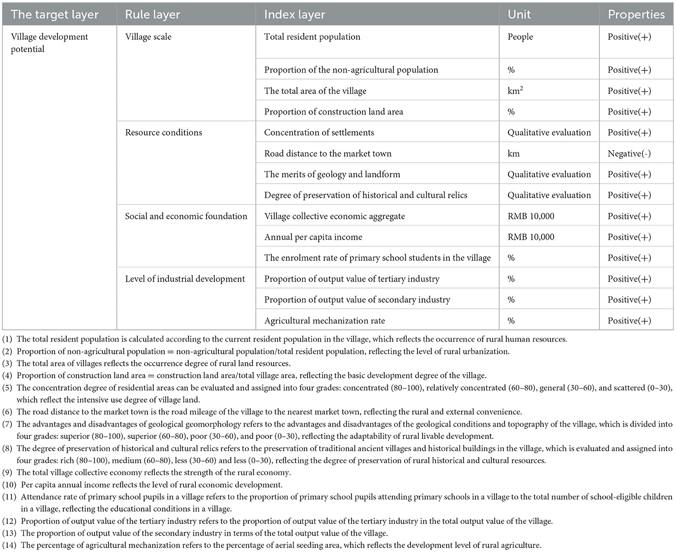
Table 1. Selection of evaluation indicators for village development potential.
2.2.2. Determination of index weight
The analytic hierarchy process (AHP) method is a subjective evaluation method suitable for analyzing multi-factor and multi-level problems. This study uses AHP to determine the cross-impact analysis (CIA) weight coefficients of various influencing factors. The operation steps of this method can be divided into the following four aspects:
Establish a hierarchical structure model: analyze the decision-making purpose and its decisive factors and construct a hierarchical structure diagram based on their interrelationships. Construct a judgment matrix: compare the decision factors in pairs to determine the relative importance of the two factors. This value is generally determined through the nine-point scale method to determine the hierarchical ranking. AHP has two sorting methods: the sum-product and the root square. In this study, the sum-product method is used to calculate the weights of each factor.
(1) Normalize each column of data in judgment matrix B
(2) Add the judgment matrix by column to obtain a one-dimensional vector
(3) Normalize a one-dimensional vector to obtain an approximate solution W for the desired feature vector
(4) Calculate the maximum eigenvalue of the judgment matrix according to the formula
Consistency check: the smaller the CR value, the correct input of the relationship between the relative importance numbers of the judgment matrix. If the CR value is <0.1, it is determined that the knowledge matrix satisfies the consistency test, where n represents the order of the judgment matrix.
This study first makes a hierarchical comparison, then sorts the importance of each evaluation index, determines the influence weight of the next layer of factors on the target of the previous layer, and constructs the factor judgment matrix. Then, the normalized eigenvectors and eigenvalues of the judgment matrix are calculated according to the root method. Finally, the consistency test is carried out, and the index weights of each factor can be obtained after the consistency test is passed. Through a series of steps above, the ranking weights of alternatives are calculated (Table 2).
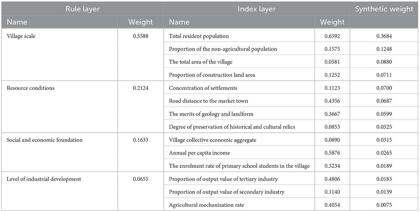
Table 2. Composite weight of village development potential evaluation index.
2.2.3. Standardized processing of data
This study selected the relevant data for each village in Zhiyang Town at the end of 2019. When standardizing the original data of each indicator in the evaluation process of village development potential, there are two situations between the evaluation factors and the evaluation objects: one is a positive relationship; that is, the larger the value of the evaluation factor, the more the village development potential will be increased. The second is a negative relationship; that is, the greater the value of the evaluation factor index, the worse the development potential of the village. For these two cases, there are two standardized treatment formulas:
Positive indicators: Pij = (xij-min xij)/(max xij-min xij)
Negative indicators: Pij = (xij-max xij)/(min xij-max xij).
2.3. Study area and data source
2.3.1. Study area
Zhiyang Town is located to the southwest of Hancheng City, Shaanxi Province, China. The town government is 17 km away from the urban area. It borders Huanglong County and Yan'an City to the west and is connected to Zhichuan Town in the east, south, and north. The Xihan Railway and Hanhe Highway run through the town, covering an area of 173 km2, with 158 villagers in 25 administrative villages under its jurisdiction. Most villages in the town are concentrated in the middle and east of the town, where the terrain is flat, and transportation is convenient. The elevation of the town is between 550 and 1,100 m, high in the west and low in the east, with Huanglong Mountain in the west and the Loess Plateau Gully Region in the east (Figure 1).
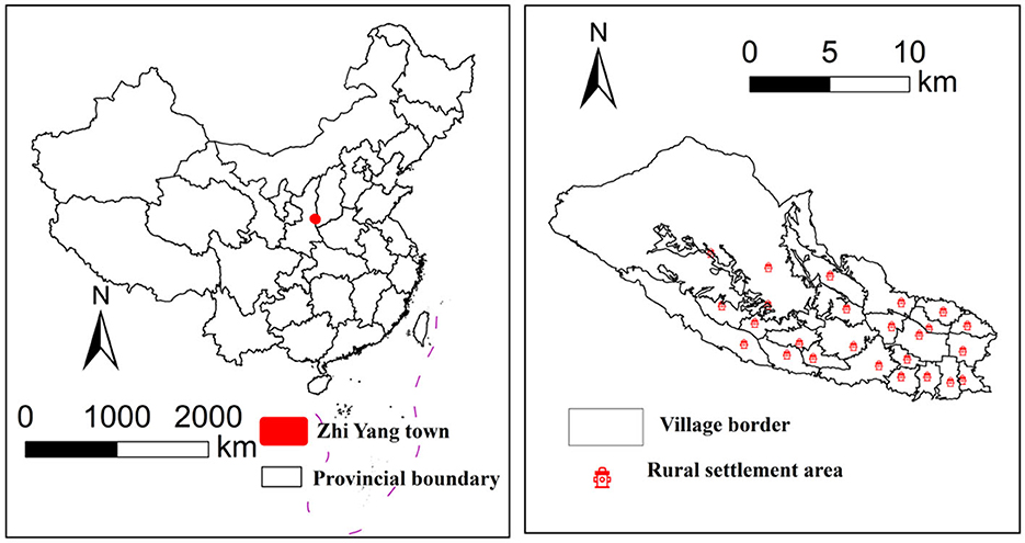
Figure 1. The location of the Zhiyang town.
2.3.2. Data source
The socio-economic data of the village came from the field survey conducted in January 2019, and the basic data of each village were obtained based on interviews and surveys. Land-use data were obtained from the Resource and Environmental Science Data Center of the Chinese Academy of Sciences (https://www.resdc.cn/Default.aspx). Township and village boundary data were collected from the National Geographic Information Resource Directory Service System (https://www.webmap.cn/commres.do?method=globeDetails&type=brief).
3. Results
3.1. Characteristics of land use change in Zhiyang town from 1980 to 2020
From the perspective of land use distribution and transfer (Figure 2), arable land, woodland, and grassland are the main types of land use. From 1980 to 2000, the arable land area was the largest, with 9,266.13 ha remaining unchanged and 69.21 ha transferred to construction land. The largest amount of grassland was transferred, with 302.13 ha of grassland converted to arable land. The volume of water bodies, construction land, and forest land transfers is very small and stable.
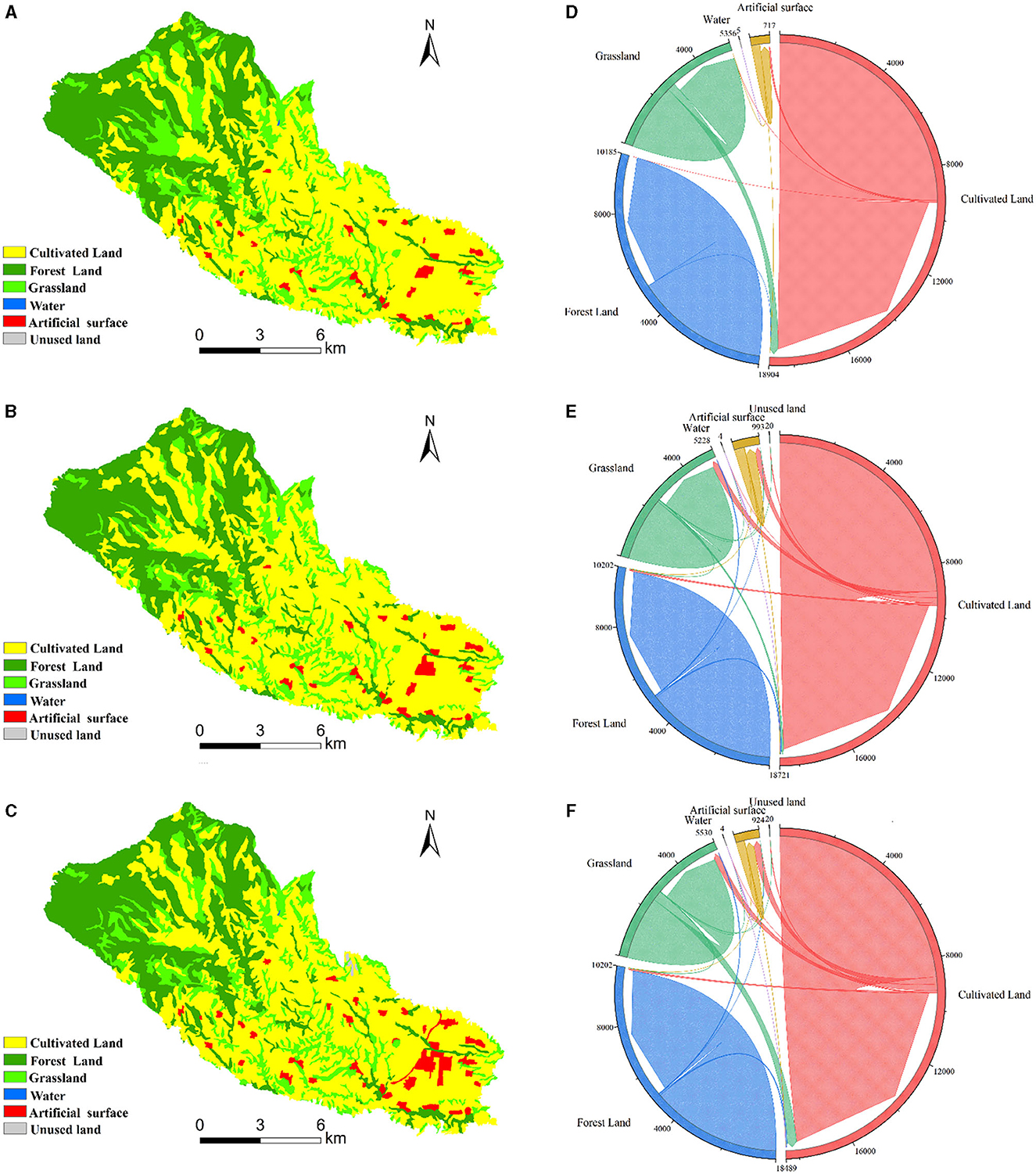
Figure 2. The land use distribution of Zhiyang town. (A) 1980 (B) 2000 (C) 2020 and chord diagram of land use transfer. (D) 1980–2000, (E) 2000–2020, (F) 1980–2020. Unit: ha.
From 2000 to 2020, more cultivated land, woodland, and grassland were transferred than in the previous 20 years. Among them, 245.79 ha of cultivated land was transferred to grassland, 216.81 ha was transferred to construction land, and 82.89 ha was transferred to woodland. 57.96 ha of woodland was transferred to arable land and 25.2 ha to grassland. 80.73 ha of grassland was transferred to arable land.
Generally speaking, during the 40 years from 1980 to 2020, land-use transfer primarily involved the three main types—arable land, woodland, and grassland, which remained relatively stable overall.
3.2. Assessment and grading of rural development potential
3.2.1. Evaluation of village development potential
According to the evaluation index and index weight, the sub-index and comprehensive index of each criterion layer of the village's comprehensive development potential are calculated (Table 3).
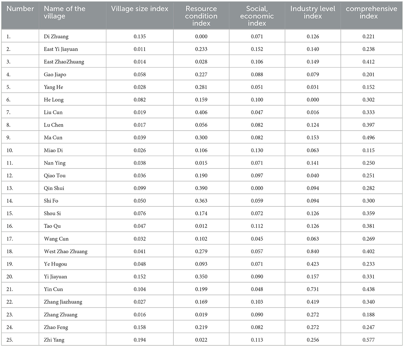
Table 3. Evaluation results of village indices.
Based on ArcGIS 10.2, the scores of each index of the villages were spatially displayed by the natural break point method, and the spatial distribution maps of each index level of 25 villages were obtained (Figure 3).
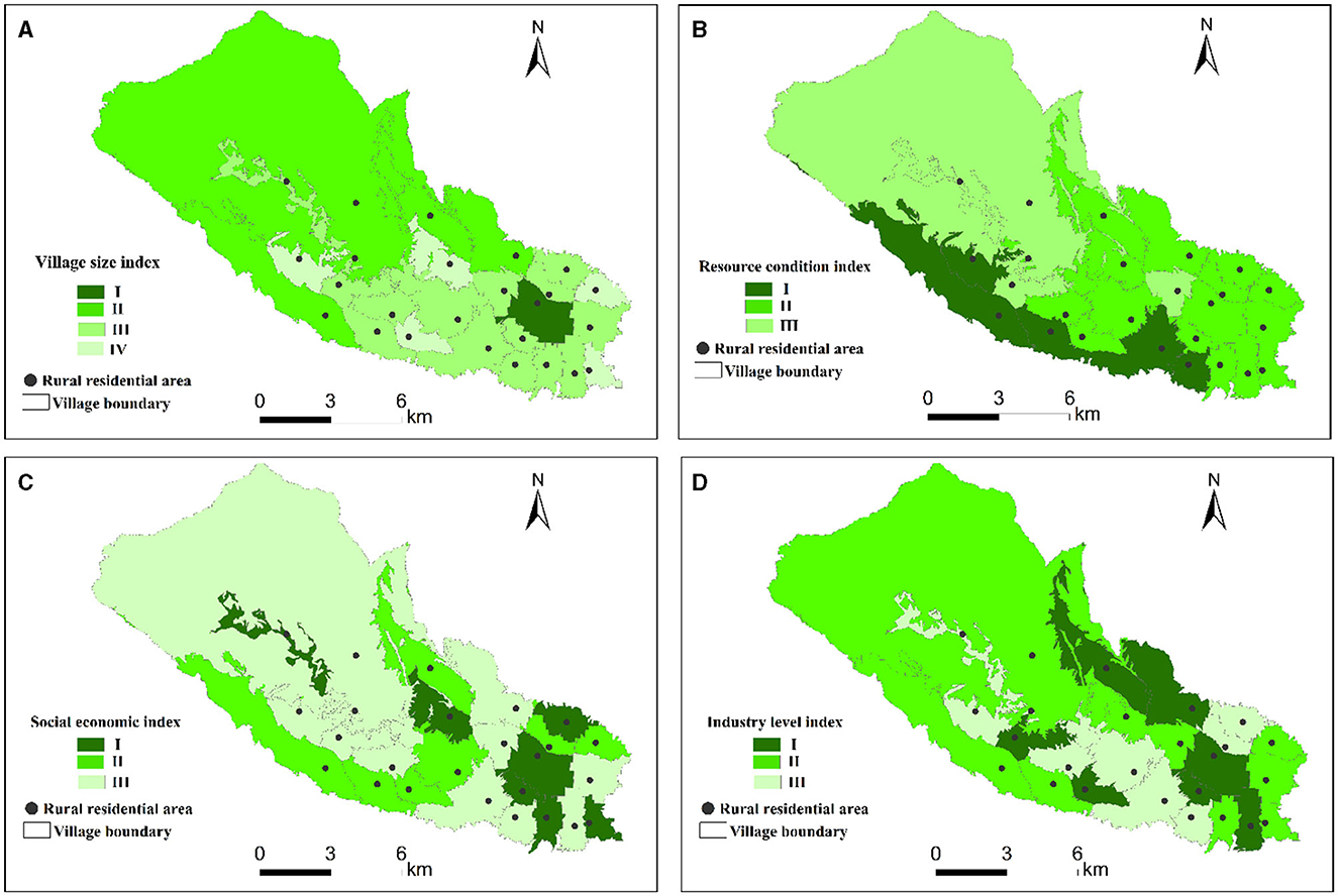
Figure 3. The evaluation results of the four indices. (A) Village size index. (B) Resource condition index. (C) Social economic index. (D) Industry level index.
The spatial distribution patterns of village size, resource conditions, social economy, and industrial levels in the study area are positively correlated. These patterns radiate from the town center, reflecting the progressively nested influence factors influencing village development.
A good scale of village size and abundant resources have led to a developed social economy and a high level of industrialization. At the same time, it shows that the selection of indicators and weight calculation in this study are scientific and reasonable.
3.2.2. Reconstruction of village hierarchy
According to the analysis of the evaluation results of village development potential, on this basis, the villages are divided into four grades: class I, class II, class III, and class IV, considering the village reality and the service radius of village infrastructure and public service facilities. Among them, the villages with grade I had a better foundation and the strongest strength. Evaluation grade II village development potential is medium. Evaluation grade III village development potential is general. The development potential of villages with grade IV is poor (Figure 4).
Figure 4. Spatial distribution of village hierarchy.
3.3. Path analysis of village system reconstruction in Zhiyang town
According to the comprehensive analysis and judgment of the results of the village classification system, 25 villages in Zhiyang Town can be classified into the types of reservation and promotion and cancellation and consolidation, among which the villages of class I, II, and III are classified into the type of reservation and promotion, and the villages of class IV are the type of cancellation and consolidation. The reconstruction path of the village hierarchy system is an important research topic in rural spatial layout. Targeted analysis and discussion should be made on the development path of two villages with different types of characteristics to realize rural revitalization by classification.
3.3.1. Development path of reserved villages
In village areas with advantageous features such as flat terrain, convenient transportation, and abundant water resources, priority is given to cultivating crops such as Chinese prickly ash, peaches, and apples. These areas already demonstrate strong industrial development and high yields, offering promising prospects for advancing modern agriculture. While these villages excel in cultivation and animal breeding, further attention is needed for the development of secondary and tertiary industries. We should encourage the development of villages specializing in agriculture, industry, trade, and leisure services by giving full play to our comparative advantages and strengthening the support of leading industries. The specific promotion approaches can be summarized as follows: (1) In terms of industrial development, based on the existing industrial foundation, an industrial linkage mode should be created to promote the expansion of village industrial functions and business forms. Villages with good basic agricultural conditions can rely on their resource advantages to introduce secondary production and processing, highlight the added value of agricultural products, extend the traditional agricultural industry chain, and expand the multiple functions of agriculture. Villages with a prominent village processing basis, special techniques, and manual manufacturing are mainly used as core resources to promote the development of the raw material planting industry. At the same time, complementary services and supporting services can be expanded to form a complete industrial chain and drive the industrial transformation and upgrading of villages. For villages with good ecological resource protection and pleasant rural scenery, it is suitable to develop a deep-level “tourism economy,” relying on leisure agriculture and cultural tourism industries to promote the development of agricultural tourism and experience and other related industries. (2) Regarding talent revitalization, rural industry aggregation will drive population return, form a new population aggregation, reverse the development trend of village hollowing, attract returning entrepreneurs and tourists, drive village revitalization with talent revitalization, and create a new “modern farmer” system. (3) Strengthen the optimization of land use, promote the efficient use of rural land, implement the “increase and decrease” policy, and effectively solve the land use constraints for rural construction and development. Make idle land use, especially in the management of rural idle homesteads. (4) In terms of cultural promotion, mining village cultural resources, refining village cultural symbols, and creating village characteristic cultural brands. Develop rural tourism, promote rural cultural inheritance, and promote the diversified development of local culture and traditional folk art.
3.3.2. The reconfiguration approach to revocation village
Considering the fact that the villages are located adjacent to each other and the scale is small, it is suggested to merge two neighboring villages with relatively small populations. The residents' living conditions will not change, but the organization at the village level will be abolished, and the office space and facilities will be further strengthened. (1) To dismantle a village-level organization, careful and thorough communication efforts are crucial. It is essential to establish a stable ideological understanding among village cadres and the community at large. To the outgoing village cadres, conscientiously do a good job of ideological and political work and properly solve the problems of the outgoing village cadres. (2) Promulgating corresponding supporting measures to lay a good foundation for the withdrawal and village work. First, the village finance and assets liquidation leading group and the village work steering group. The second is the newly merged village party's basic-level organization reconstitution, which has a clear stipulation for the outgoing village cadre's treatment and so on. Third, the party and government cover village cadres and village cadres in an all-round way into the village, group, and household to do a good job of withdrawing and village propaganda, launching, and dealing with the specific problems in withdrawing and village. The fourth is to strengthen the collection of information, timely feedback, and village work information. (3) Improve withdrawal and merger procedures according to the law. The work of disintegrating villages shall be carried out strictly in accordance with the law and the plan. First, convening meetings by law. By holding a meeting of all villagers over the age of 18 or a meeting of household representatives to solicit the opinions of the masses, decide whether to withdraw the village or not, and build a new village name and a village committee residence. Second, it is named according to the law. In the process of withdrawing and merging villages, the naming and renaming of new villages are reported and approved based on soliciting the opinions of the masses.
4. Discussion
4.1. Rural spatial layout is a necessary way to achieve rural revitalization
There are over 550,000 administrative villages and 3.17 million natural villages in China. What are the types, quantities, and spatial distribution of these villages? Which rural areas bear the functions of national food security, meat, milk, eggs, fruit, and vegetable agricultural products, which rural areas bear the ecological protection function, and which rural areas play an important role in cultural inheritance, and how should different types and functions of rural areas be built in the process of carrying out rural construction actions?
Clarify the layout of different rural functions in the land space of rural areas, further consolidate the foundational and strategic position of rural areas in ensuring agricultural product safety, meet the requirements for achieving high-quality development in rural society, and carry out national positioning of rural functions.
(1) Further positioning the fundamental and strategic position of rural areas in terms of national agricultural product security from the perspective of territorial spatial layout Based on China's socio-economic development and residents' needs, analyze the constraints of food safety, ecological safety, and global agricultural product circulation, and use big data technology to analyze and judge the production and consumption of agricultural products. Clarify which types of rural areas bear the food safety guarantee function, construct a national layout of agricultural product function bases based on rural areas, and consolidate the safe supply of agricultural products to the rural level, effectively strengthening the basic and strategic areas for ensuring the safety of agricultural products in rural revitalization.
(2) Provide more precise guidance for policy formulation, funding investment, and classified implementation of infrastructure construction for national rural construction. Defining the functions of rural areas nationwide is beneficial for governments at all levels to introduce more precise, targeted, and scientific policies. It is beneficial for the country to carry out infrastructure construction planning in different categories based on different rural functional positioning and improve the effectiveness of infrastructure construction, effectively targeting the needs of rural funding investment for different functional types, budget funding investment needs, and improving the effectiveness of national funding investment.
(3) Provide a theoretical basis for the scientific evaluation of rural construction actions. The function and layout of rural space are some of the key measures to promote rural construction actions in various regions. After positioning the rural functions of each region, it is conducive to conducting differential evaluations of the implementation effectiveness of different types of rural construction in the same region, vertical evaluations of the effectiveness of rural construction in different regions of the same type, and the development of unified indicators, standards, and scales. It is also conducive to conducting qualitative and quantitative evaluations of the same type of rural area, improving the comparability of evaluations and the scientificity of evaluation results.
(4) Provide top-level solutions for integrating rural social development into rural construction actions. The positioning of rural functions integrates rural social development into the national agricultural product production function, effectively solving the long-standing problem of the construction of agricultural infrastructure and rural infrastructure.
The approach effectively addresses the issue of focusing on agricultural production factors and infrastructure construction investment while neglecting rural infrastructure construction investment, which is conducive to coordinating various social resources and increasing investment in rural areas, thereby promoting the implementation of a rural revitalization strategy.
The important means of rural spatial reconstruction is to use village and town layout planning as a starting point, reconstruct villages' production and living spaces, and build a social security system that coordinates urban and rural development. Therefore, conducting a scientific reconstruction of future rural spaces to distinguish between key villages and general villages, as well as identifying relocated and merged villages, to avoid duplicate or inefficient construction of public service facilities such as housing, village-level education, healthcare, elderly care, and water and electricity networks in these villages, has reference and inspiration significance for the implementation of China's rural revitalization strategy and rural planning research.
4.2. The contradiction between the decrease in the rural population and the increase in rural residential area
The analysis of recent population changes in Zhiyang town shows (Figure 5) that from the era of reform and opening up until the turn of the century, the town's population increased steadily. However, after 2005, the population began to decline, with the most significant decrease occurring between 2016 and 2017. This trend in the village labor force is largely consistent with the overall trend in the village population. This is due to the acceleration of the pace of new urbanization, a large number of rural young and middle-aged labor forces into the city, and rural hollowing caused by the aggravation.
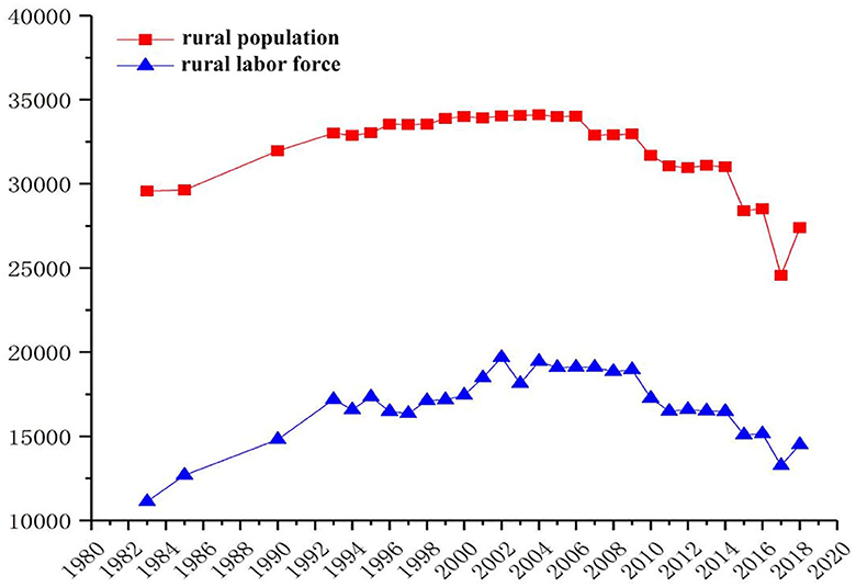
Figure 5. Changes in the rural population.
Over the past 40 years, the size of rural residential areas in Zhiyang Town has grown significantly, among which 282.6 ha were converted from farmland, along with an additional 6.12 ha that had previously been neglected (Figure 6).
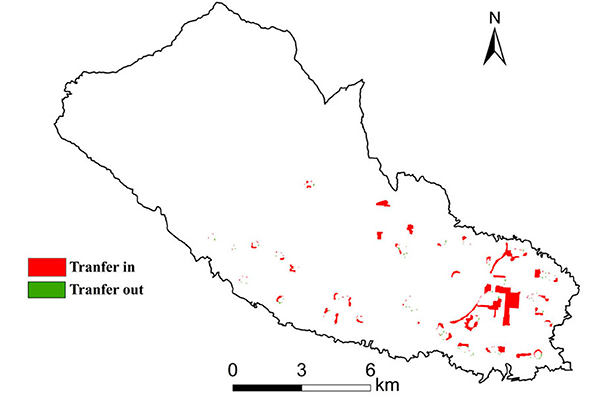
Figure 6. Spatial distribution of rural residential transfer from 1980 to 2020.
Despite the rapid development of the social economy leading to a significant reduction in the rural population, the area allocated to rural farming continues to increase, which profoundly reflects the current situation of China's rural areas (Ward et al., 2003; Wen et al., 2020; Wang et al., 2021). According to our research, it is urgent to evaluate the development potential of villages, grade and classify villages, organize and merge hollow villages that have no development potential, and strictly control the construction and expansion scale of rural residential areas (Yang et al., 2016; Xu et al., 2022; Yu et al., 2022).
4.3. Reconstruct the rural spatial distribution system and formulate the classification standard for rural construction
Based on clarifying the development potential of rural areas, different development support policies should be formulated according to different evaluation levels to provide a basis for promoting rural infrastructure construction by classifying and clarifying the key points of construction and investment (Zhang D. et al., 2020; Zeng et al., 2021; Zhang et al., 2022). With the county level as the unit, we will issue guidelines for regional norms and standards for rural construction, guide all regions to formulate a system of rural construction standards, guide and standardize rural construction action plans with standards (Zheng et al., 2014; Zhao et al., 2019; Zhang T. et al., 2020), and provide implementation standards and standards for rural infrastructure construction, service infrastructure construction, and industrial infrastructure construction (Zhong, 2020; Zhou et al., 2020, 2021).
4.4. Policy suggestions
(1) Improve the village spatial planning system. Through regional population, economic, and industrial development trends, optimize the future place of the construction of rural settlements and population scale, improve the village layout structure, merge small villages, reduce natural villages, demolition of hollow villages, village protection characteristics, promote urban population, industrial park to the central land scale operation to the central, form a reasonable arrangement in rural settlements layout structure.
(2) To promote theoretical and methodological research for identifying characteristics of different types of villages. Based on the village system construction method, the index system of village classification is proposed. Combined with the classification of village types, the scientific and accurate classification and identification of villages in the study area are carried out based on local policies, and the best path of rural optimization development is proposed for different types.
(3) According to the requirements of the central plan, focusing on the differentiated development of different types of areas in rural construction is to achieve development tailored to local conditions. This means that in the process of promoting rural construction, it is necessary to classify the construction according to the actual situation of different regions so there can be more specific measures to promote the rural revitalization strategy.
First, economically developed regions can focus on developing new industries such as characteristic agriculture and tourism. These regions have a good economic foundation and advantageous resources and can increase farmers' income and improve their quality of life by creating distinctive agricultural product brands and developing tourism resources. For example, by developing high-quality organic agricultural products and leveraging local customs and the natural environment, these areas attract more consumers and increase farmers' income. At the same time, characteristic tourism projects such as rural homestays and farmhouses can be developed to attract tourists for sightseeing and create more job opportunities.
Second, economically underdeveloped areas can focus on protecting and restoring the ecological environment while developing industries such as ecotourism. These regions are rich in natural resources, and by protecting and restoring the ecological environment, they can attract more tourists and achieve sustainable development. For example, it can promote the improvement of farmland water conservancy projects, improve the construction and management level of farmland water conservancy facilities, and ensure a good ecological environment for farmland. At the same time, by carrying out rural tourism activities such as natural scenery and folk culture, attracting tourists to sightseeing, promoting rural economic transformation and upgrading, and achieving the unity of economic and ecological benefits.
4.5. Limitations and prospects of research
This study introduces potential evaluation into village classification and development strategy research. On the one hand, the number of obstacle factors for village development is used to determine the relocation, merger, and consolidation of villages. On the other hand, differentiated village zoning development strategies are developed based on the main obstacle factors of each village. The strategy formulation is more targeted, which helps to accurately control the development of each village and achieve rural revitalization. In addition, this study includes two closely related topics: village classification and zoning. Village classification judges the characteristics and potential of village development from the perspective of individual villages. However, even villages of the same type have significant differences in their development characteristics, advantages, and weaknesses. Villages with different endowment conditions or obstacles may also be classified as villages of the same type. Therefore, it is unscientific and impractical to propose differentiated development strategies solely from the perspective of village classification. As mentioned earlier, villages in adjacent spaces often have similar endowment conditions or obstacles. Differentiated development strategies based on village zoning can more scientifically guide regional rural development practices. Therefore, it is recommended to add the content of village development zoning to the process of village classification and layout planning as a beneficial supplement to village classification and to scientifically guide regional rural revitalization and development according to local conditions and circumstances. Finally, due to limitations in the research area and data availability, this study's selection of obstacle factors focuses on the characteristics of villages in mountainous and hilly areas, which may not apply to plain areas.
Moreover, due to the characteristics of the mountainous and hilly areas, village land has the characteristics of multiple patches, small areas, and scattered distribution, making it difficult to obtain natural village scale data. Therefore, this study only focuses on the administrative village scale. In the future, when the data conditions are met, the applicability of identifying obstacle factors in different regions and scales in village classification and zoning research can be explored.
5. Conclusion
Using the AHP and GIS analysis, this study takes Zhiyang Town of Han City as an example to grade its 25 villages and puts forward the development path of different grades of villages. (1) This study constructed a set of index systems to evaluate the village level. The system consists of four dimensions: village scale, resource conditions, social economy, industrial level, and 14 second-level indicators. (2) Based on the division scheme of the village hierarchy system, a whole set of reconstruction paths for the rural system are proposed, starting with the retention and upgrading of villages and the cancellation of the consolidation of villages, respectively.
We propose targeted construction standards for villages across various systems and categories, covering everything from infrastructure construction to public service facilities. It is of great significance in promoting the comprehensive development and revitalization of rural areas.
In the future, we can continue to verify the rationality of this evaluation method on a larger scale and further carry out large-scale village evaluations.
Data availability statement
The original contributions presented in the study are included in the article/supplementary material, further inquiries can be directed to the corresponding author.
Author contributions
Conceptualization: YF. Methodology, software, writing—original draft preparation, and writing—review and editing: ZZ. Validation: HW and JY. Formal analysis: HW. Funding acquisition: YF. All authors have read and agreed to the published version of the manuscript.
Funding
This research was funded by Shaanxi Province's 2022 Provincial Grain Special Project (Shaanxi Grain Reserve Safety Early Warning and Emergency Management Strategy Research), the 2022 Shaanxi Provincial Association for Science and Technology Decision-making Consulting Project (Research on the Industrial Model of Comprehensive Land Remediation in the Background of Rural Revitalization), and the Shaanxi Provincial Forestry Science and Technology Innovation Program Special Project (grant number SXLK20200102).
Conflict of interest
The authors declare that the research was conducted in the absence of any commercial or financial relationships that could be construed as a potential conflict of interest.
Publisher's note
All claims expressed in this article are solely those of the authors and do not necessarily represent those of their affiliated organizations, or those of the publisher, the editors and the reviewers. Any product that may be evaluated in this article, or claim that may be made by its manufacturer, is not guaranteed or endorsed by the publisher.
References
Abdulai, M., Ibrahim, H., and Latif Anas, A. (2023). The role of indigenous communication systems for rural development in the tolon district of Ghana. Res. Globalizat. 6, 100128. doi: 10.1016/j.resglo.2023.100128
Abreu, I., Mesías, F. J., and Ramajo, J. (2022). Design and validation of an index to measure development in rural areas through stakeholder participation. J. Rural Stud. 95, 232–240. doi: 10.1016/j.jrurstud.2022.09.022
Addai, G., Suh, J., and Bardsley, D. (2023). Contributions of urban periodic markets to sustainable rural development in Ghana: a rural web analysis. Social Sciences & Humanities Open 7, 100480. doi: 10.1016/j.ssaho.2023.100480
Allawi, A. H., and Al-Jazaeri, H. M. J. (2023). A new approach towards the sustainability of urban-rural integration: the development strategy for central villages in the Abbasiya District of Iraq using GIS techniques. Region. Sustainab. 4, 28–43. doi: 10.1016/j.regsus.2023.02.004
Andersson, A., Höjgård, S., and Rabinowicz, E. (2017). Evaluation of results and adaptation of EU rural development programmes. Land Use Policy 67, 298–314. doi: 10.1016/j.landusepol.2017.05.002
Bu, X. G., Pu, L. J., Shen, C. Z., Xie, X. F., and Xu, C. Y. (2020). Study on the spatial restructuring of the village system at the county level oriented toward the rural revitalization strategy: a case of Jintan District, Jiangsu Province. Land 9, 478. doi: 10.3390/land9120478
Chen, J., Wang, C., Dai, R. L., Xu, S., Shen, Y., and Ji, M. Z. (2021). Practical village planning strategy of different types of villages-a case study of 38 villages in Shapingba District, Chongqing. Land 10, 143. doi: 10.3390/land10111143
Chen, M., Zhou, Y., Huang, X., and Ye, C. (2021). The integration of new-type urbanization and rural revitalization strategies in china: origin, reality and future trends. Land 10, 207. doi: 10.3390/land10020207
Chen, N. N., and Kong, L. (2022). Rural revitalization in China: towards inclusive geographies of ruralization. Dial. Human Geogr. 12, 213–217. doi: 10.1177/20438206221102933
Chen, X. W. (2020). The core of China's rural revitalization: exerting the functions of rural area. China Agric. Econ. Rev. 12, 1–13. doi: 10.1108/CAER-02-2019-0025
Chen, Y., and Liu, Y. (2011). Rural development evaluation from territorial function angle: a case of Shandong Province. J. Northeast Agricult. Univ. (English Edition) 18, 67–74. doi: 10.1016/S1006-8104(13)60086-0
Dong, Y., Cheng, P., and Kong, X. S. (2022). Spatially explicit restructuring of rural settlements: a dual-scale coupling approach. J. Rural Stud. 94, 239–249. doi: 10.1016/j.jrurstud.2022.06.011
Eversole, R., and Campbell, P. (2023). Building the plane in the air: articulating neo-endogenous rural development from the ground up. J. Rural Stud. 101, 103043. doi: 10.1016/j.jrurstud.2023.103043
Gu, X. K., Xie, B. M., Zhang, Z. F., and Guo, H. (2019). Rural multifunction in Shanghai suburbs: Evaluation and spatial characteristics based on villages. Habitat Int. 92. doi: 10.1016/j.habitatint.2019.102041
Gutu Sakketa, T. (2023). Urbanisation and rural development in sub-Saharan Africa: a review of pathways and impacts. Res. Globalizat. 6, 100133. doi: 10.1016/j.resglo.2023.100133
Han, J. (2020). Prioritizing agricultural, rural development and implementing the rural revitalization strategy. China Agric. Econ. Rev. 12, 14–19. doi: 10.1108/CAER-02-2019-0026
He, T. Q., Qiao, W. F., Jia, K. Y., Chai, Y. B., Hu, Y., Sun, P., et al. (2020). Selecting rural development paths based on village multifunction: a case of Jingjiang City, China. Complexity 2020, 942. doi: 10.1155/2020/7590942
Hebinck, P., Smith, L., and Aliber, M. (2023). Beyond technocracy: the role of the state in rural development in the Eastern Cape, South Africa. Land Use Policy 126, 106527. doi: 10.1016/j.landusepol.2022.106527
Hermawati, W., Ririh, K. R., Ariyani, L., Helmi, R. L., and Rosaira, I. (2023). Sustainable and green energy development to support women's empowerment in rural areas of Indonesia: Case of micro-hydro power implementation. Ener. Sustain. Dev. 73, 218–231. doi: 10.1016/j.esd.2023.02.001
Hlaváček, P., Kopáček, M., Kopáčkov,á, L., and Hruška, V. (2023). Barriers for and standpoints of key actors in the implementation of smart village projects as a tool for the development of rural areas. J. Rural Stud. 103, 103098. doi: 10.1016/j.jrurstud.2023.103098
Hossain, M., Park, S., and Shahid, S. (2023). Frugal innovation for sustainable rural development. Technol. Forecast. Soc. Change 193, 122662. doi: 10.1016/j.techfore.2023.122662
Kallert, A., Belina, B., Miessner, M., and Naumann, M. (2021). The Cultural Political Economy of rural governance: regional development in Hesse (Germany). J. Rural Stud. 87, 327–337. doi: 10.1016/j.jrurstud.2021.09.017
Koutridi, E., and Christopoulou, O. (2023). The importance of integrating Smart Farming Technologies into Rural Policies (Aiming at sustainable rural development)- stakeholders' views. Smart Agricult. Technol. 4, 100206. doi: 10.1016/j.atech.2023.100206
Lapuz, M. C. M. (2023). The role of local community empowerment in the digital transformation of rural tourism development in the Philippines. Technol. Soc. 74, 102308. doi: 10.1016/j.techsoc.2023.102308
Li, H. B., Jin, X. B., Liu, J., Feng, D. Y., Xu, W. Y., and Zhou, Y. K. (2022). Analytical framework for integrating resources, morphology, and function of rural system resilience-an empirical study of 386 villages. J. Clean. Prod. 365 doi: 10.1016/j.jclepro.2022.132738
Li, Y. R., Liu, Y. S., Long, H. L., and Cui, W. G. (2014). Community-based rural residential land consolidation and allocation can help to revitalize hollowed villages in traditional agricultural areas of China: Evidence from Dancheng County, Henan Province. Land Use Policy 39, 188–198. doi: 10.1016/j.landusepol.2014.02.016
Lin, J. H. (2022). Research on village planning and rural architectural design based on discrete dynamic modeling technology. Scient. Program. 2022 doi: 10.1155/2022/9031664
Lin, Y. Y., Shui, W., Li, Z. P., Huang, S., Wu, K. X., Sun, X. R., et al. (2021). Green space optimization for rural vitality: Insights for planning and policy. Land Use Policy 108, 105545. doi: 10.1016/j.landusepol.2021.105545
Liu, S., Ge, J., Bai, M., Yao, M., He, L. Y., and Chen, M. (2022). Toward classification-based sustainable revitalization: Assessing the vitality of traditional villages. Land Use Policy 116, 106060. doi: 10.1016/j.landusepol.2022.106060
Liu, X., Liu, Y., Rui, Y., Zhang, J., and Zhao, X. (2022). Evaluation of sustainable agriculture and rural development in agro-pastoral ecotone under climate change: a comparative study of three villages in the Shenfu coalfield, China. J. Rural Stud. 93, 504–512. doi: 10.1016/j.jrurstud.2019.12.016
Liu, X., Liu, Z., Zhong, H., Jian, Y., and Shi, L. (2021). Multi-dimension evaluation of rural development degree and its uncertainties: a comparison analysis based on three different weighting assignment methods. Ecol. Indic. 130, 108096. doi: 10.1016/j.ecolind.2021.108096
Liu, Y. S., Zang, Y. Z., and Yang, Y. Y. (2020). China's rural revitalization and development: Theory, technology and management. J. Geograph. Sci. 30, 1923–1942. doi: 10.1007/s11442-020-1819-3
Long, X., Yang, P. F., and Su, Q. M. (2023). On the effective organization of rural settlements spatial structure under the transformation and development of mountainous areas in Western China: evaluation measurement based on complex adaptability theory. Environ. Sci. Pollut. Res. Int. 30, 89945–89963. doi: 10.1007/s11356-022-23266-4
López-Penabad, M. C., Iglesias-Casal, A., and Rey-Ares, L. (2022). Proposal for a sustainable development index for rural municipalities. J. Clean. Prod. 357, 131876. doi: 10.1016/j.jclepro.2022.131876
Luo, Y. B., and Qi, L. H. (2019). Construction and practice of a conservation plan implementation evaluation system for historic villages. J. Asian Archit. Build. Eng. 18, 351–361. doi: 10.1080/13467581.2019.1661843
Ma, W. Q., Jiang, G. H., Zhang, R. J., Li, Y. L., and Jiang, X. G. (2018). Achieving rural spatial restructuring in China: a suitable framework to understand how structural transitions in rural residential land differ across peri-urban interface? Land Use Policy 75, 583–593. doi: 10.1016/j.landusepol.2018.04.024
McGuire, R., Longo, A., and Sherry, E. (2022). Tackling poverty and social isolation using a smart rural development initiative. J. Rural Stud. 89, 161–170. doi: 10.1016/j.jrurstud.2021.11.010
Niu, B., Ge, D., Sun, J., Sun, D., Ma, Y., Ni, Y., et al. (2023). Multi-scales urban-rural integrated development and land-use transition: the story of China. Habitat Int. 132, 102744. doi: 10.1016/j.habitatint.2023.102744
Pan, W., Wang, J., Qin, X. F., and Li, Y. R. (2021). Trends and types of rural residential land use change in China: a process analysis perspective. Growth Change 52, 2437–2452. doi: 10.1111/grow.12563
Park, S., Chapman, R., and Munroe, D. K. (2022). Examining the relationship between migration and land cover change in rural U.S.: evidence from Ohio, United states, Betweem 2008 and 2016. J. Land Use Sci. 17, 60–78. doi: 10.1080/1747423X.2021.2020920
Qu, Y., Dong, X., Zhan, L., Si, H., Ping, Z., and Zhu, W. (2021a). Scale transition and structure-function synergy differentiation of rural residential land: a dimensionality reduction transmission process from macro to micro scale. Land 10, 647. doi: 10.3390/land10060647
Qu, Y., Dong, X., Zhan, L., Zhu, W., Wang, S., Ping, Z., and Zhang, B. (2022). Achieving rural revitalization in China: a suitable framework to understand the coordination of material and social space quality of rural residential areas in the plain. Growth Chang. 53, 1052–1081. doi: 10.1111/grow.12536
Qu, Y., Jiang, G. H., Li, Z., Tian, Y., and Wei, S. (2019). Understanding rural land use transition and regional consolidation implications in China. Land Use Policy 82, 742–753. doi: 10.1016/j.landusepol.2018.11.014
Qu, Y., Zhan, L., Jiang, G., Ma, W., and Dong, X. (2021b). How to address “population decline and land expansion (PDLE)” of rural residential areas in the process of Urbanization: A comparative regional analysis of human-land interaction in Shandong Province. Habitat Int. 117, 102441. doi: 10.1016/j.habitatint.2021.102441
Rao, Y., Zou, Y., Yi, C., Luo, F., Song, Y., and Wu, P. (2023). Optimization of rural settlements based on rural revitalization elements and rural residents' social mobility: a case study of a township in western China. Habitat Int. 137, 102851. doi: 10.1016/j.habitatint.2023.102851
Robinson-Pant, A. (2023). Education for rural development: forty years on. Int. J. Educ. Dev. 96, 102702. doi: 10.1016/j.ijedudev.2022.102702
Ruml, A., Chrisendo, D., Iddrisu, A. M., Karakara, A. A., Nuryartono, N., Osabuohien, E., et al. (2022). Smallholders in agro-industrial production: lessons for rural development from a comparative analysis of Ghana's and Indonesia's oil palm sectors. Land Use Policy 119, 106196. doi: 10.1016/j.landusepol.2022.106196
Shan, Z. Y., and Feng, C. C. (2018). The redundancy of residential land in rural china: the evolution process, current status and policy implications. Land Use Policy 74, 179–186. doi: 10.1016/j.landusepol.2017.07.031
Suárez Roldan, C., Méndez Giraldo, G. A., and López Santana, E. (2023). Sustainable development in rural territories within the last decade: a review of the state of the art. Heliyon 9, e17555. doi: 10.1016/j.heliyon.2023.e17555
Torre, A., Wallet, F., and Huang, J. (2023). A collaborative and multidisciplinary approach to knowledge-based rural development: 25 years of the PSDR program in France. J. Rural Stud. 97, 428–437. doi: 10.1016/j.jrurstud.2022.12.034
Vaishar, A., and Štastná, M. (2023). Economically underdeveloped rural regions in Southern Moravia and possible strategies for their future development. J. Rural Stud. 97, 356–364. doi: 10.1016/j.jrurstud.2022.12.024
Wang, S. T., Bai, X. M., Zhang, X. L., Reis, S., Chen, D. L., Xu, J. M., et al. (2021). Urbanization can benefit agricultural production with large-scale farming in China. Nature Food 2, 183. doi: 10.1038/s43016-021-00228-6
Ward, M. H., Giglierano, J., Wolter, C., Miller, R. S., Nuckols, J. R., and Hartge, P. (2003). How accurately does geocoding determine residential locations in rural and urban areas? Epidemiology 14, S102–S103. doi: 10.1097/00001648-200309001-00246
Wen, Y. Y., Zhang, Z. F., Liang, D., and Xu, Z. (2020). Rural residential land transition in the Beijing-Tianjin-Hebei region: spatial-temporal patterns and policy implications. Land use policy 96. doi: 10.1016/j.landusepol.2020.104700
Willett, J. (2023). Place-based rural development: a role for complex adaptive region assemblages? J. Rural Stud. 97, 583–590. doi: 10.1016/j.jrurstud.2023.01.008
Xu, L., Zhao, H. Y., Chernova, V., Strielkowski, W., and Chen, G. N. (2022). Research on rural revitalization and governance from the perspective of sustainable development. Front. Environm. Sci. 10, 839994. doi: 10.3389/fenvs.2022.839994
Yanbo, Q., Guanghui, J., Wenqiu, M., and Zitong, L. (2021). How does the rural settlement transition contribute to shaping sustainable rural development? Evidence from Shandong, China. J. Rural Stud. 82, 279–293. doi: 10.1016/j.jrurstud.2021.01.027
Yang, R., Xu, Q., and Long, H. L. (2016). Spatial distribution characteristics and optimized reconstruction analysis of China's rural settlements during the process of rapid urbanization. J. Rural Stud. 47, 413–424. doi: 10.1016/j.jrurstud.2016.05.013
Yu, T. T., Leng, H., Yuan, Q., and Jiang, C. Y. (2022). Vulnerability evaluation of villages based on social-ecological indicators and strategies for improvement: case study of villages in the Northeast China Plain. J. Urban Plann. Dev. 148, 770. doi: 10.1061/(ASCE)UP.1943-5444.0000770
Zeng, X. G., Zhao, Y. N., and Cheng, Z. Y. (2021). Development and research of rural renewable energy management and ecological management information system under the background of beautiful rural revitalization strategy. Sustain. Comput-Inform. Syst. 30, 100553. doi: 10.1016/j.suscom.2021.100553
Zhang, D., Gao, W., and Lv, Y. (2020). The triple logic and choice strategy of rural revitalization in the 70 years since the founding of the people's Republic of China, based on the perspective of historical evolution. Agricult-Basel 10, 40125. doi: 10.3390/agriculture10040125
Zhang, R. Y., Ma, C. X., Wu, D. G., Wu, Y. L., and Wang, K. (2022). The evaluation and optimization methods of villages in China: in the background of a rural revitalization strategy. Comput. Intell. Neurosci. 2022, 7314446. doi: 10.1155/2022/7314446
Zhang, T., Ding, B., Hu, Q., Liu, Y., Zhou, D., Gao, W., et al. (2020). Research on regional system planning method of rural habitat in gully regions of the loess plateau, under the background of rural vitalization strategy in China. Sustainability 12, 83317. doi: 10.3390/su12083317
Zhao, Y. J., Leng, H., Sun, P. J., and Yuan, Q. (2019). Application and validation of a municipal administrative area spatial zoning model in village-town system planning. Sustainability 11, 855. doi: 10.3390/su11071855
Zheng, X. Y., Wei, C., Qin, P., Guo, J., Yu, Y. H., Song, F., et al. (2014). Characteristics of residential energy consumption in China: findings from a household survey. Energy Policy 75, 126–135. doi: 10.1016/j.enpol.2014.07.016
Zhong, Y. F. (2020). Study on rural residential construction models and strategies in Southern Shaanxi under the background of rural rejuvenation based on ecological theory. Fresenius Environm. Bullet. 29, 6571–6575.
Zhou, J. J., Hua, C., Wu, S. S., Wang, Z. R., and Wang, X. K. (2021). Sustainable village planning indicator system in rural transformation: application to xufu village in the Yangtze river delta Region in China. J. Urban Plann. Dev. 147, 768. doi: 10.1061/(ASCE)UP.1943-5444.0000768
Keywords: rural revitalization, village potential, spatial layout, typical township, China
Citation: Zhu Z, Wang H, Yang J and Feng Y (2023) Reconstructing village spatial layout to achieve rural revitalization: a case from a typical township in China. Front. Sustain. Food Syst. 7:1168222. doi: 10.3389/fsufs.2023.1168222
Received: 17 February 2023; Accepted: 15 September 2023;
Published: 12 October 2023.
Edited by:
Yongsheng Wang, Chinese Academy of Sciences (CAS), ChinaReviewed by:
Sheng-Hau Lin, Ningbo University, ChinaYing Wang, China University of Geosciences Wuhan, China
Copyright © 2023 Zhu, Wang, Yang and Feng. This is an open-access article distributed under the terms of the Creative Commons Attribution License (CC BY). The use, distribution or reproduction in other forums is permitted, provided the original author(s) and the copyright owner(s) are credited and that the original publication in this journal is cited, in accordance with accepted academic practice. No use, distribution or reproduction is permitted which does not comply with these terms.
*Correspondence: Yongzhong Feng, fengyz@nwsuaf.edu.cn