The Temporal-Based Forest Disturbance Monitoring Analysis: A Case Study of Nature Reserves of Hainan Island of China From 1987 to 2020
 Han Xiao
 Xiaoqian Zhang1,3
  Hua Wang
- 1Aerospace Information Research Institute, Chinese Academy of Science, Beijing, China
- 2School of Electronic, Electrical and Communication Engineering, University of Chinese Academy of Science, Beijing, China
- 3School of Marine Technology and Geomatics, Jiangsu Ocean University, Lianyungang, China
- 4Key Laboratory of Earth Observation of Hainan Province, Hainan Research Institute, Aerospace Information Research Institute, Chinese Academy of Sciences, Sanya, China
Forest disturbance monitoring can provide scientific data for the decision making and management of nature reserves. LandTrendr algorithm has been applied to identify forest disturbances on a long-time scale through appropriate segmentation and linear fitting. In this study, 23 nature reserves were detected using LandTrendr during 1987–2020, and the vegetation loss was quantified by years and pixel numbers. The results illustrated that (1) most disturbances occurred in the 1990s and early 21st century. (2) From the spatial distribution of forest loss, the area of forest vegetation disturbance in the coastal zone was larger than the protected area in the internal Hainan Island, the area disturbed in the coastal zone protected area was 97.12 km2, and the area disturbed in the internal area of Hainan Island protected area was 63.02 km2. (3) In terms of different levels of nature reserves, the disturbed area of national nature reserves was 28.39 km2 and the total disturbed area of provincial nature reserves was 131.75 km2. (4) In terms of different types of nature reserves, forest ecological nature reserves had the largest disturbed area of 102.96 km2, followed by marine coastal nature reserves with a disturbed area of 36.99 km2, wildlife nature reserves with a disturbed area of 10.22 km2, and wild plant nature reserves with the smallest disturbed area of 9.96 km2. The results are hoped to provide scientific support and data for the management and planning of nature reserves in Hainan Island.
1 Introduction
A forest plays an important role in the terrestrial ecosystem, and its dynamic change could directly affect the carbon cycle and carbon storage of the terrestrial forest ecosystem (Bonan, 2008; Fahey et al., 2010). Subtropical forest coverage in China has increased significantly since the 1980s. However, forest ecosystems are usually disrupted by natural impacts such as forest fires and typhoons, or by human behaviors such as logging and burning (Curtis et al., 2018; Chuvieco et al., 2018; Wu Honggan and Miao, 2021). The habitat quality of forest ecosystems has declined and global forests have been significantly destroyed, and the influence of human activities has gradually increased (Tong et al., 2020; Xiao et al., 2022; Li, 2000). Nature reserves are the core areas of biodiversity protection (Hu et al., 2009). The establishment of nature reserves is one of the most direct and effective measures to protect the biodiversity in biological habitats. Strengthening and developing the cause of nature reserves is the core work of ecological environmental protection (Poiani et al., 2000). With the increasing population and the acceleration of urbanization, the contradiction between the development of nature reserves and human activities has become increasingly frequent. Therefore, it is of great significance to grasp the temporal and spatial changes of vegetation disturbances in nature reserves and to find out the law of changes for alleviating the contradiction between the economic development and ecological maintenance of nature reserves (Brooks et al., 2004; Peres et al., 2010).
Traditional forest change monitoring was mainly based on field research with intensive labor and time costs (Klein Goldewijk and Ramankutty, 2004; Huang, 2018). It is difficult to meet the needs of the present forest survey on a regional scale. With the development of remote sensing, it became an important method for forest disturbance monitoring because of its macroscopic and real-time nature (Klein Goldewijk and Ramankutty, 2004; Hansen et al., 2010; Townshend et al., 2012). In the past 20 years, MODIS and AVHRR images were broadly used in forest changes because of the high temporal resolution and large coverage (Hansen et al., 2002). Landsat images provided data support for forest disturbance monitoring with high spatial and temporal resolution (Woodcock et al., 2008). Therefore, a time series image analysis was applied to identify forest disturbances (Huang et al., 2009; Verbesselt et al., 2010; Jamali et al., 2015). LandTrendr algorithm was first developed by Kennedy (Kennedy et al., 2010), which collected available Landsat images to obtain time-scaled vegetation disturbance information annually (Yang et al., 2018). To reach a wide research and application group, LandTrendr algorithm is implemented on the Google Earth Engine (GEE) platform, which greatly improves the computational efficiency and provides opportunities for large-scale application in the nature reserve protection (Griffiths et al., 2014; Pericak et al., 2018; Zhu et al., 2020; Hua et al., 2021).
Hainan is a tropical island with rich biodiversity in China, and nature reserves are important ecological constructions for the protection of precious vegetation and animals. Nature reserves in Hainan Island have experienced disturbances due to natural and human activities. Therefore, we adopted LandTrendr algorithm to detect forest disturbances in 23 nature reserves of Hainan Island using LandsatTM/ETM + OLI images. Two indices were used to quantify the forest loss-disturbed years and areas. Finally, the temporal and spatial changes of forest disturbances were analyzed to obtain the general conditions of forest disturbances in Hainan Island in the past 34 years.
2 Materials and Methods
2.1 Study Area
Hainan Island is the largest tropical region with the lowest latitude in China. It is located on the northern edge of the tropics. Hainan Island has developed and preserved the largest area of tropical rainforests and has rich biodiversity in China (Liu et al., 2006). It is of special significance in the protection of global tropical rainforests and biodiversity. Presently, Hainan Island has 68 nature reserves, including 8 national-level reserves, 23 provincial ones, and 37 municipal and county-level ones. Fifty-six of them are land nature reserves, and the 12 remaining ones are marine nature reserves. The ecosystem structure of Hainan Island in the context of ecological function zones is based on sustaining and protecting biodiversity, water conservation, water resource protection, and coastal zone protection (Figure 1). The disturbance caused by human activities from tourism and economic development has relatively increased in the reserved area. In addition, due to the profound influence of the sea and land location, natural disasters such as high temperatures and typhoons occur frequently in summer and forest disturbance changes occur significantly. Therefore, we explore the time of disturbance. The disturbance quantity and other driving factors are of great significance in the management of nature reserves.
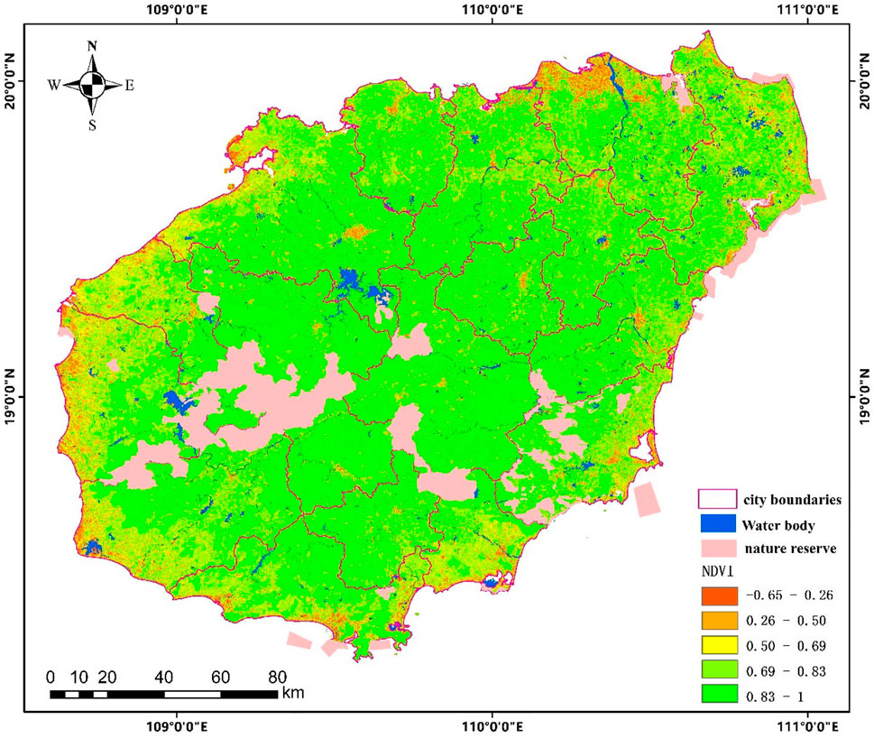
FIGURE 1. Spatial distribution of Hainan Island natural reserves. The pink area shows the spatial distribution of the study area. The boundary data come from the Hainan Academy of Environmental Sciences.
Twenty-three nature reserves in Hainan Island were selected for this study. The details of the nature reserves are described in Table 1.
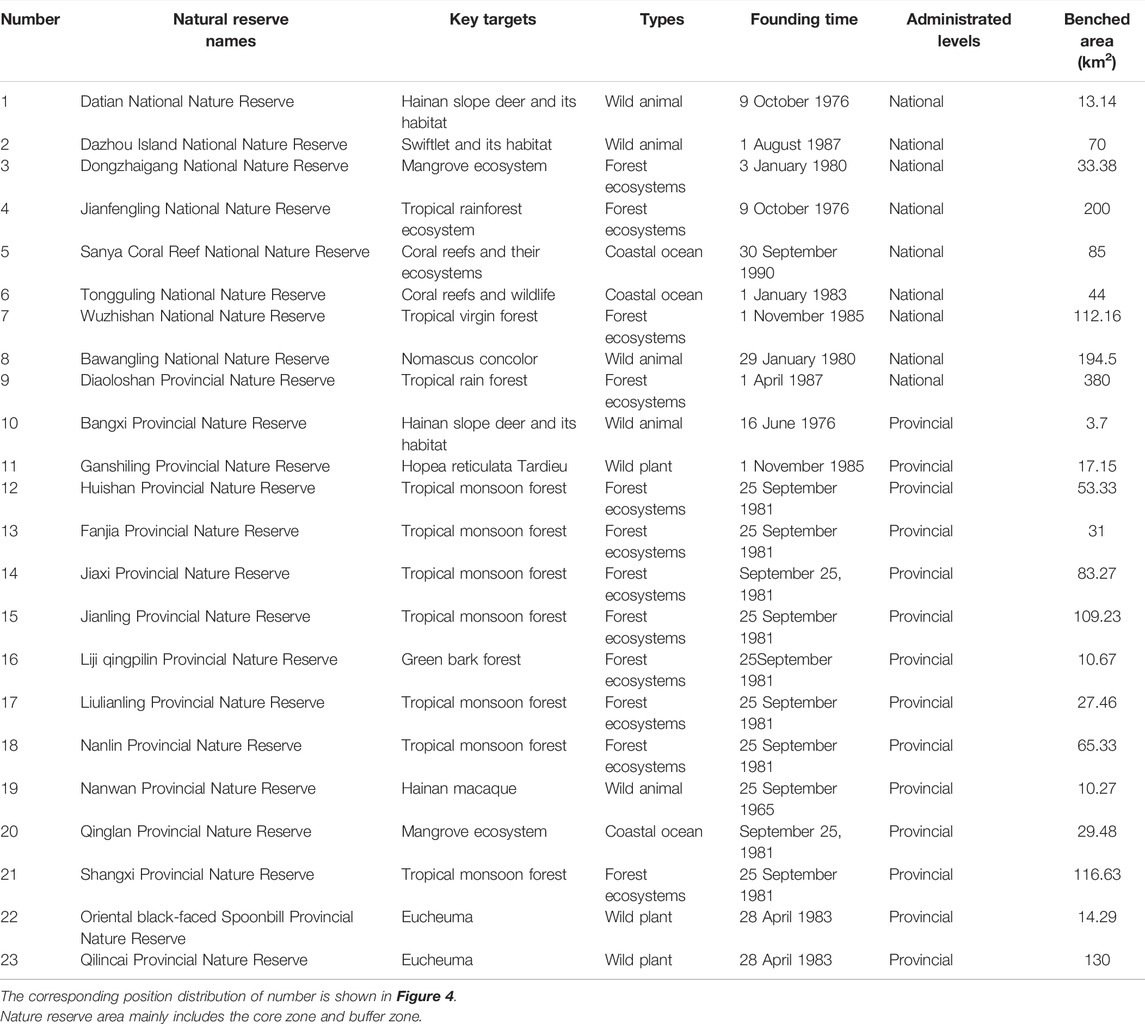
TABLE 1. Overview of Hainan Island natural reserves.
2.2 Data Description
The Landsat TM/ETM+/OLI images from 1987 to 2020 were selected according to (1) the vegetation growing seasons (from June to September) based on reducing the disturbance of phenology on vegetation spectral recognition (Zhong, 2020) and (2) to ensure a relatively high image quality in timescales, less cloud cover images optioned.
2.3 Methodology
2.3.1 Time Series Synthesis
LandsatLinkr (LLR) is an automatic Landsat image processing system related to data preprocessing module LandTrendr algorithm (http://jdbcode.github.io/LandsatLinkr/). LLR is designed for the systematic spatial analysis based on Landsat images, linking MSS, TM, ETM+, and OLI data. Cloud mask-embedded Landsat data have been used to mask the clouds and construct cloud-free images annually. LLR is synthesized based on Landsat Level 2 temporal data of the seasonal growth annually (day of year: 150–240). First, each image mask is with the mask file of the cloud and cloud shadow. An annual data link is attributed to its geographic coordinates and based on the value of pixels with replicated observation. The calculation formula is as follows:
where xi,j represents one observation value of the pixel at the coordinate of (i,j) in a certain year, n represents the total number of observations of the input image in this year, and y_(i,j) represents the output value of the coordinate of (i,j) after synthesis.
2.3.2 The Option of Spectral Index
The normalized difference vegetation index (NDVI) and normalized burn ratio (NBR) were used to construct temporal data for disturbance monitoring. Based on a large amount of data, some studies have shown that the NDVI and NBR have great sensitivity to various types of disturbance events (Cohen et al., 2010; Kennedy et al., 2010). The NBR is composed of near-infrared (NIR) which is sensitive to the chlorophyll content of vegetation and short-wave infrared (SWIR) which is sensitive to the water vapor content. A healthy vegetation has a high NBR value in terms of high NIR and low SWIR values, while the disturbed pixel demonstrates soil characteristics, the increased SWIR value, and decreased NBR value. Hence, forest change information can be identified in accordance with the NBR mutation temporal track:
2.3.3 LandTrendr Parameter Settings
GEE adopts nine parameters for LandTrendr algorithm, among which eight are used to adjust the control parameters of the spectral time segmentation and annual image collection. To obtain more appropriate parameters, the researcher has made several attempts and selected the main parameters in Table 2.
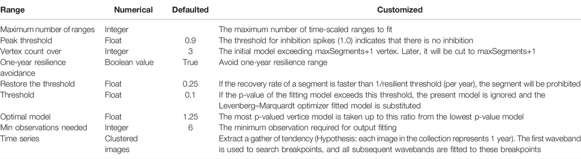
TABLE 2. LandTrendr key parameter list.
2.3.4 Segmentation of Disturbance Results
Since the disturbance intensity calculated could not directly reflect the changes in forest disturbance, the natural breakpoint method was adopted in this study to classify the disturbance intensity into several levels. The disturbance results are segmented into levels 1–7 (Table 3).
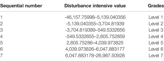
TABLE 3. The results can be divided into seven levels according to the intensity value of disturbance.
3 Results
3.1 Analysis of the Inter-Annual Variation of Vegetation Disturbance Intensity in Nature Reserves
Disturbed forest areas from 1987 to 2020 in the nature reserves of Hainan Island were obtained using LandTrendr. Disturbances in Hainan nature reserves mainly occurred in the late 19th century and early 20th century from 1987–2020 (Figure 2). We calculated the inter-annual forest disturbance changes in Hainan nature reserves, as shown in Figure 3. The inter-annual variation of forest disturbance varied in the nature reserves and showed a decreasing trend in the past 34 years, with a total disturbed area of 160.14 km2, accounting for 24% of the total area of Hainan nature reserves. The disturbed area was the largest in 1991, with an area of 36.38 km2 and the smallest one was in 2020. The disturbed areas in 1988, 1989, 1991, and 1992 were more than 10 km2, which were the four most affected years. The total disturbed areas of Hainan nature reserves were 122.68 km2 (1990–2000), 65.70 km2 (2000–2010), and 15.67 km2 (2010–2020), respectively. With a significant total reduction in the past 34 years, the disturbed areas were less than 2 km2 since 2010, and the forest disturbance area tends to be stable gradually.
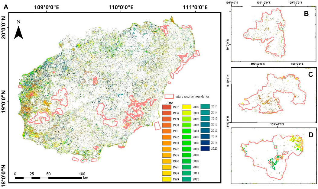
FIGURE 2. Forest disturbance in Hainan National nature reserves from 1987 to 2020. (A) The disturbed area of forest vegetation in Hainan nature reserves from 1987 to 2020 and the change of disturbed area in different years. (B) Forest disturbance in Bawangling National Nature Reserve. (C) Forest disturbance in Jianfengling National Nature Reserve. (D) Forest disturbance in Ganshiling Provincial Nature Reserve.
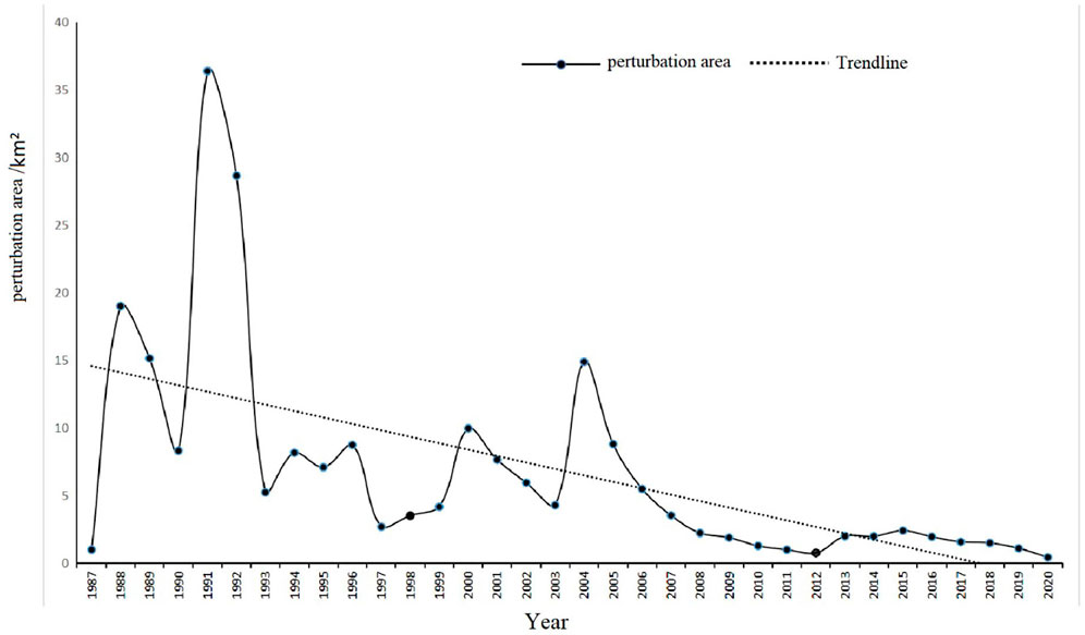
FIGURE 3. Annual area map of forest disturbance in Hainan nature reserves from 1987 to 2020. Forest disturbance in Hainan reserves mainly occurred in the late 19th century and early 20th century from 1987–2020.
3.2 Spatial Feature Intensity Analysis of Vegetation Disturbance of Natural Reserves
Figure 4 demonstrates the spatial distribution of forest disturbance in Hainan nature reserves. Affected by natural disasters like typhoons and human activities, the forest disturbance magnitude in the coastal reserves was higher than the nature reserves of inner Hainan Island. Among the coastal reserves, Qinglan Provincial Nature Reserve and Liji Qingpilin Provincial Nature Reserve were the two reserves with the largest forest disturbance areas. The disturbance areas were 23.14 and 18.64 km2 respectively, followed by the Oriental Black-Faced Spoonbill Provincial Nature Reserve, which was significantly disturbed in the context of a disturbance area of 10.23 km2.
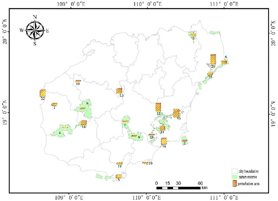
FIGURE 4. Spatial distribution of the forest disturbance area in Hainan nature reserves. There are mainly tropical rainforest national parks in the island, including Diaoloshan Provincial Nature Reserve, Jianfengling National Nature Reserve, Wuzhishan National Nature Reserve, and Bawangling National Nature Reserve. Natural reserves’ name and number, please refer to Table 1.
Based on field surveys and literature research, such as the Qinglan Provincial Nature Reserve and Oriental Black-Faced Spoonbill Provincial Nature Reserve, the local reserve management department was lacking in professional talent, and the breeding pond gradually became the main source of income for the residents, along with the increase in protection (Guo Julan et al., 2015). In recent years, the development of mangrove restoration reduced the disturbed forest area and improved the ecological environment of the reserve. The Qing Pi Forest Reserve was mainly affected by tourism, which resulted in the destruction of vegetation areas. The local funeral culture was also a main reason for the destruction of the Hainan Hopea (Wang Yonghua and Weng, 2003).
3.3 Analysis of Grade Distribution Characteristics of Vegetation Disturbance Intensity in Nature Reserves
The multi-grades of forest vegetation disturbance are shown in Figure 5. The forest disturbance intensity of Hainan nature reserves was mainly at grades 2–4, with less at grade 5 and the least at grades 6 and 7. Our cartographic analysis was carried out on the results for forest disturbance intensity level improvement.
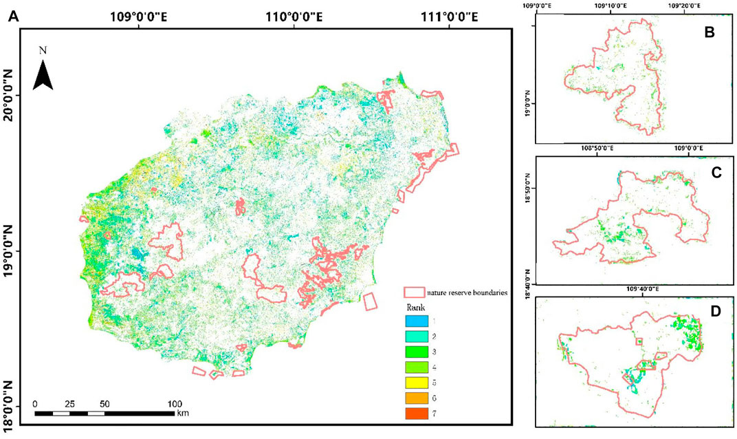
FIGURE 5. Grade distribution map of forest disturbance intensity in nature reserves. (A) Forest disturbance intensity of the three typical nature reserves in Hainan Island is 2–4, 5 is less, and 6 and 7 are the least. (B) Grade distribution map of Bawangling National Nature Reserve. (C) Grade distribution map of Jianfengling National Nature Reserve. (D) Grade distribution map of Ganshiling Provincial Nature Reserve.
3.4 Multi-Grade Forest Disturbance
The multi-grades of nature reserve disturbance were classified according to the different levels of nature reserve administrations and the reserves level. Different levels of disturbance areas of the nature reserves and the inter-annual changes are shown in Figure 6, because the quantity of provincial nature reserves accounted for 70% of the whole Hainan Island reserve (Liu Jinfu et al., 2020). Hence, the overall disturbance area of provincial nature conservation was the largest area, with a total area of 131.75 km2, and that of national nature reserves was 28.39 km2.
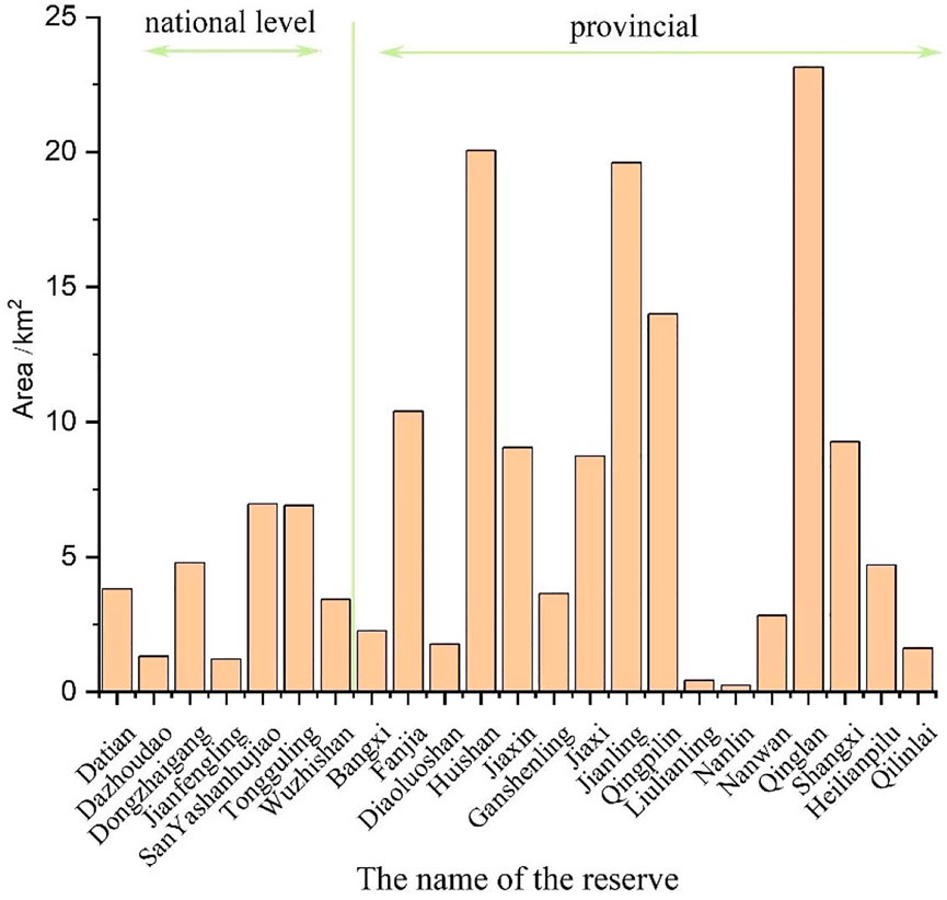
FIGURE 6. Forest disturbance area of different levels of nature reserves.
According to the field investigation, among the provincial nature reserves, the Qinglan Provincial Nature Reserve, Huishan Provincial Nature Reserve, and Jianling Provincial Nature Reserve, the development of breeding ponds was the main reason for nature reserve disturbance. Since the concept of conservation has not been deeply rooted in people’s minds and the management of the reserve has not played its due role, the phenomenon of local aquaculture pond encroachment in mangroves has always existed. Until 2017, the “Green Shield” special action was carried out and the policy of “returning ponds to forests” was implemented resulting in the reduction of the disturbance of nature reserves. The disturbances of the Huishan Provincial Nature Reserve and Jianling Provincial Nature Reserve were mainly attributed to deforestation and the core disturbance occurred from 1989–1992.
3.5 The Variations of Multi-Type Forest Disturbance
According to the ecological environment of the People’s Republic of China issued by the list of nature reserves of Hainan Province, the selected nature reserves in this study were mainly divided into four types of wildlife nature reserves: wild animals, forest ecology, wild plants, and ocean coast reserve. Figure 7 shows the disturbed forest area for different types of nature reserves in the past 34 years.
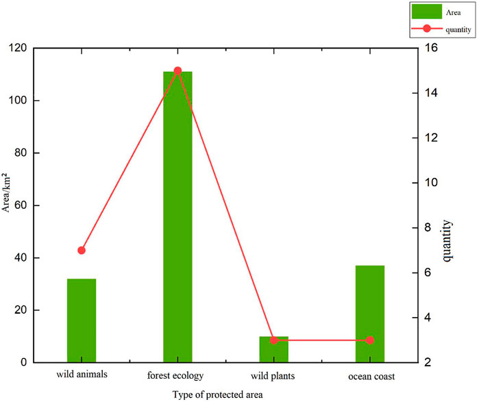
FIGURE 7. Forest disturbance area of different types of protected areas.
In the analysis of the 23 nature reserves, 12 forest ecology reserves were included, accounting for 52% of the total nature reserves in this study. The wild animal nature reserves accounted for 22%. Wild plants and ocean coast nature reserves accounted for 13%. As shown in Figure 7, the disturbed area of forest ecology nature reserves was the largest (141.88 km2), followed by ocean coast nature reserves (37 km2), wild animal nature reserves (33.79 km2), and wild plant nature reserves (9.96 km2).
4 Discussion
In this study, LandTrendr algorithm was used to extract the key surface spectral information based on the temporal data change track, time-scaled appropriate segmentation and linear fitting, and image de-noising spectrum information. It is essential to simplify the complicated adjacent sections of straight lines to the point and capture the disturbance factors and obtain the annual perturbation and disturbance. We used LandTrendr algorithm to study the forest disturbance and its changes in Hainan nature reserves from 1987 to 2020, which could help realize the analysis of the inter-annual and spatial changes of vegetation disturbance in the nature reserves, and multiple types and grades of nature reserve vegetation disturbance changes are analyzed based on the analyzed disturbance results. It can facilitate scientific data construction for the administrations of the local reserved area and reduce the consumption of human and material resources via remote sensing technology and from model driven to data driven (Liu et al., 2022).
The issue of developing the combination of the local satellite remote sensing monitoring is an important aspect of research. The high-resolution-based images can analyze small-scaled regions further because of lower reserve disturbance precision. Our research shows the driving factors of the disturbance based on the previous results and analyzes the experimental correlation between the disturbance and the main driving factors. It harnesses the key driving factors of the disturbance and benefits to nature reserves administration.
The driving factors of forest disturbance could be divided into human and natural factors, of which human factors played a dominant role (Han et al., 2012; Runguo Zang et al., 1999). The forest coverage rate of Hainan Island increased from 21.67 to 57.36%, ranking sixth in the China National Survey. In the 1980s and 1990s, the Hainan forest disturbance was serious, mainly resulting from deforestation, breeding pond development, and other economic activities. Since the 1990s, local people began to realize the serious consequences of deforestation, and many provinces and cities conducted scientific afforestation and forest resource management through the establishment of nature reserves (Zhai et al., 2014). From the perspective of different dominant tree species, the forest area of Hainan Island was dominated by eucalyptus and casuarina, and gradually changed to broadleaved mixed forests. The removal of deforestation, Hainan as a coastal province, and the breeding pond expansion were also important reasons for the disturbance. The literature shows that part of the reserves were disturbed in 1987; the Hainan offshore aquaculture area was characterized by a substantial increase, peaked in 2015, and faced a slow decline after 2015, especially large-scale port provincial nature reserves. It is a typical area for the large-scale development of aquaculture ponds in Hainan Island. Additionally, as Hainan Island is the only tropical island in China, natural disasters occur frequently. Extreme weather conditions such as typhoons and rainstorms are significant causes of forest disturbance.
5 Conclusion
LandTrendr algorithm of the GEE cloud platform was applied to detect forest disturbance using Landsat satellite images, and the long-span monitoring and analysis of forest disturbance in nature reserves of different grades and types in Hainan Island were conducted from 1987 to 2020. The main conclusions are as follows:
1) According to the forest detection based on LandTrendr, the forest disturbance mainly occurred from 1988–1992 in Hainan Island nature reserves in the past 34 years, and the disturbance affected the most was 36.38 km2 in 1991; the total disturbed area of Hainan nature reserves was 122.68 km2 (1990–2000), 65.70 km2 (2000–2010), and 15.67 km2 (2010–2020). In the past 34 years, the disturbed area of the forest revealed a dramatically downward trend. Since 2010, the disturbance area has been less than 2 km2, and the forest disturbance area gradually stabilized.
2) The spatial analysis of disturbance in ocean coast nature reserves was significantly greater than that of inner nature reserves because coastal nature reserves were vulnerable to natural disasters like typhoons and high temperatures. In addition, the economic developmental activities are mostly located along the coastal zone and strongly disturbed by human activities.
3) Provincial nature reserves were the largest disturbed segmentation in terms of the multi-grade change analysis (total area: 131.75 km2). The second-largest was the national nature reserves (Total area: 28.39 km2). The main reason was that provincial nature reserves were the most reserved regions in Hainan Island, accounting for 57% of the total reserved area studied. In addition, the administration level of provincial areas was lower than that of national ones and with a lack of professional talent.
4) Based on the multi-type change analysis, the sizes of the disturbed area were listed in descending order:1) forest ecological nature reserve (largest:102.96 km2); 2) marine and coastal nature reserve (36.99 km2); 3) wild animal nature reserve (10.22 km2); and 4) wild plant nature reserve (least: 9.96 km2).
Data Availability Statement
The raw data supporting the conclusion of this article will be made available by the authors, without undue reservation.
Author Contributions
Software, MY; writing original draft preparation, HX; writing review and editing, XZ; visualization, HW and YM; and supervision, LZ and JL.
Funding
This research was funded by the Hainan Provincial Department of Science and Technology (Grant No. ZDKJ2019006) and Postgraduate Research & Practice Innovation Program of Jiangsu Ocean University (Grant No. SJCX20_1251).
Conflict of Interest
The authors declare that the research was conducted in the absence of any commercial or financial relationships that could be construed as a potential conflict of interest.
Publisher’s Note
All claims expressed in this article are solely those of the authors and do not necessarily represent those of their affiliated organizations, or those of the publisher, the editors, and the reviewers. Any product that may be evaluated in this article, or claim that may be made by its manufacturer, is not guaranteed or endorsed by the publisher.
References
Bonan, G. B. (2008). Forests and Climate Change: Forcings, Feedbacks, and the Climate Benefits of Forests. Science 320, 1444–1449. doi:10.1126/science.1155121
Brooks, T. M., Bakarr, M. I., Boucher, T., Da Fonseca, G. A. B., Hilton-Taylor, C., Hoekstra, J. M., et al. (2004). Coverage provided by the Global Protected-Area System: Is it Enough? BioScience 54, 1081–1091. doi:10.1641/0006-3568(2004)054[1081:cpbtgp]2.0.co;2
Chuvieco, E., Lizundia-Loiola, J., Pettinari, M. L., Ramo, R., Padilla, M., Tansey, K., et al. (2018). Generation and Analysis of a New Global Burned Area Product Based on MODIS 250 M Reflectance Bands and thermal Anomalies. Earth Syst. Sci. Data 10, 2015–2031. doi:10.5194/essd-10-2015-2018
Cohen, W. B., Yang, Z., and Kennedy, R. (2010). Detecting Trends in Forest Disturbance and Recovery Using Yearly Landsat Time Series: 2. Timesync - Tools for Calibration and Validation. Remote Sensing Environ. 114, 2911–2924. doi:10.1016/J.Rse.2010.07.010
Curtis, P. G., Slay, C. M., Harris, N. L., Tyukavina, A., and Hansen, M. C. (2018). Classifying Drivers of Global Forest Loss. Science 361, 1108–1111. doi:10.1126/Science.Aau3445
Fahey, T. J., Woodbury, P. B., Battles, J. J., Goodale, C. L., Hamburg, S. P., Ollinger, S. V., et al. (2010). Forest Carbon Storage: Ecology, Management, and Policy. Front. Ecol. Environ. 8, 245–252. doi:10.1890/080169
Griffiths, P., Kuemmerle, T., Baumann, M., Radeloff, V. C., Abrudan, I. V., Lieskovsky, J., et al. (2014). Forest Disturbances, Forest Recovery, and Changes in Forest Types across the Carpathian Ecoregion from 1985 to 2010 Based on Landsat Image Composites. Remote Sensing Environ. 151, 72–88. doi:10.1016/J.Rse.2013.04.022
Guo Julan, Z. Y., Wu, G., Guo, Z., and Wen, W. (2015). Health Assessment of Mangrove Wetland in Qinglangang, Hainan. Scientia Silvae Sinicae 51, 17–25. doi:10.1016/J.Elecom.2014.12.008
Han, X., Tushou, L., Chen, D., Mingxian, L., and Huai, Y. (2012). Impacts of Forest Logging on the Species Diversity of Endemic Seed Plants from Hainan Island. Biodiv Sci. 20, 168–176.
Hansen, M. C., Defries, R. S., Townshend, J. R. G., Sohlberg, R., Dimiceli, C., and Carroll, M. (2002). Towards an Operational Modis Continuous Field of Percent Tree Cover Algorithm: Examples Using Avhrr and Modis Data. Remote Sensing Environ. 83, 303–319. doi:10.1016/s0034-4257(02)00079-2
Hansen, M. C., Stehman, S. V., and Potapov, P. V. (2010). Quantification of Global Gross Forest Cover Loss. Proc. Natl. Acad. Sci. U.S.A. 107, 8650–8655. doi:10.1073/Pnas.0912668107
Hu, Y., Yinbo, Q., Yan, L., and Mei, Y. (2009). The In Situ Conservation of State Key Protected Wild Plants in National Nature Reserves in China. Biodiversity Sci. 17, 280–287. doi:10.3724/Sp.J.1003.2009.08293
Hua, J., Chen, G., Yu, L., Ye, Q., Jiao, H., and Luo, X. (2021). Improved Mapping of Long-Term Forest Disturbance and Recovery Dynamics in the Subtropical China Using All Available Landsat Time-Series Imagery on Google Earth Engine Platform. Ieee J. Sel. Top. Appl. Earth Observations Remote Sensing 14, 2754–2768. doi:10.1109/Jstars.2021.3058421
Huang, C. (2018). “6.03 - Forest Disturbance Mapping,” in Comprehensive Remote Sensing. Editor S. Liang (Oxford: Elsevier).
Huang, C., Goward, S. N., Schleeweis, K., Thomas, N., Masek, J. G., and Zhu, Z. (2009). Dynamics of National Forests Assessed Using the Landsat Record: Case Studies in Eastern United States. Remote Sensing Environ. 113, 1430–1442. doi:10.1016/J.Rse.2008.06.016
Jamali, S., Jönsson, P., Eklundh, L., Ardö, J., and Seaquist, J. (2015). Detecting Changes in Vegetation Trends Using Time Series Segmentation. Remote Sensing Environ. 156, 182–195. doi:10.1016/J.Rse.2014.09.010
Kennedy, R. E., Yang, Z., and Cohen, W. B. (2010). Detecting Trends in Forest Disturbance and Recovery Using Yearly Landsat Time Series: 1. Landtrendr - Temporal Segmentation Algorithms. Remote Sensing Environ. 114, 2897–2910. doi:10.1016/j.rse.2010.07.008
Klein Goldewijk, K., and Ramankutty, N. (2004). Land Cover Change over the Last Three Centuries Due to Human Activities: The Availability of New Global Data Sets. GeoJournal 61, 335–344. doi:10.1007/s10708-004-5050-z
Li, W. (2000). Analysis on World forest Resource protection and Chinese Forestry Development Strategy (In Chinese). Resour. Sci. 22, 71–76.
Liu, H. M., Jiang, J. S., and Dong, S. L. (2006). Study on Biodiversity of the Tropical Rubber Plantation in Hainan. Journal of Nanjing Forestry University Natural Sciences Edition.
Liu Jinfu, L. Y., Wu, N., and Xiong, J. (2020). Study on the Evaluation of Main Function Play of National Forest Parks in Hainan. Cent. South For. Inventory Plann. 39, 9–26.
Liu, P., Ranjan, R., Wang, L., and He, G. (2022). A Survey on Active Deep Learning: From Model-Driven to Data-Driven. ACM Computing Surveys.
Peres, C. A., Gardner, T. A., Barlow, J., Zuanon, J., Michalski, F., Lees, A. C., et al. (2010). Biodiversity Conservation in Human-Modified Amazonian forest Landscapes. Biol. Conservation 143, 2314–2327. doi:10.1016/j.biocon.2010.01.021
Pericak, A. A., Thomas, C. J., Kroodsma, D. A., Wasson, M. F., Ross, M. R. V., Clinton, N. E., et al. (2018). Mapping the Yearly Extent of Surface Coal Mining in Central Appalachia Using Landsat and Google Earth Engine. PloS one 13, e0197758. doi:10.1371/journal.pone.0197758
Poiani, K. A., Richter, B. D., Anderson, M. G., and Richter, H. E. (2000). Biodiversity Conservation at Multiple Scales: Functional Sites, Landscapes, and Networks. BioScience 50, 133–146. doi:10.1641/0006-3568(2000)050[0133:bcamsf]2.3.co;2
Runguo Zang, Y. Y., Jingyan, L., Shixiao, Y., and Xiusen, Y. (1999). Gaps and Their Natural Disturbance Regimes in the Tropical Montane Rain Forest of Hainan Island. Scientia Silvae Sinicae 35, 2–8.
Tong, X., Brandt, M., Yue, Y., Ciais, P., Rudbeck Jepsen, M., Penuelas, J., et al. (2020). Forest Management in Southern China Generates Short Term Extensive Carbon Sequestration. Nat. Commun. 11, 129. doi:10.1038/s41467-019-13798-8
Townshend, J. R., Masek, J. G., Huang, C., Vermote, E. F., Gao, F., Channan, S., et al. (2012). Global Characterization and Monitoring of forest Cover Using Landsat Data: Opportunities and Challenges. Int. J. Digital Earth 5, 373–397. doi:10.1080/17538947.2012.713190
Verbesselt, J., Hyndman, R., Newnham, G., and Culvenor, D. (2010). Detecting Trend and Seasonal Changes in Satellite Image Time Series. Remote Sensing Environ. 114, 106–115. doi:10.1016/j.rse.2009.08.014
Wang Yonghua, H. Y., and Weng, Yingyun. (2003). Qingpi Forest Nature Reserve on Hainan Island (In Chenese). Plant Mag., 8.
Woodcock, C. E., Allen, R., Anderson, M., Belward, A., Bindschadler, R., Cohen, W., et al. (2008). Free Access to Landsat Imagery. Science 320, 1011. doi:10.1126/science.320.5879.1011a
Wu Honggan, W. C., Miao, Z., et al. (2021). Study on Early Warning Technology of Sub-health State of Forest Resources with Spaceborne Remote Sensing. Remote Sensing Technology Appl. 36, 1121–1130.
Xiao, H., Liu, J., He, G., Zhang, X., Wang, H., Long, T., et al. (2022). Data-Driven Forest Cover Change and its Driving Factors Analysis in Africa. Front. Environ. Sci. 9. doi:10.3389/fenvs.2021.780069
Yang, Y., Erskine, P. D., Lechner, A. M., Mulligan, D., Zhang, S., and Wang, Z. (2018). Detecting the Dynamics of Vegetation Disturbance and Recovery in Surface Mining Area via Landsat Imagery and LandTrendr Algorithm. J. Clean. Prod. 178, 353–362. doi:10.1016/j.jclepro.2018.01.050
Zhai, D.-L., Cannon, C. H., Dai, Z.-C., Zhang, C.-P., and Xu, J.-C. (2014). Deforestation and Fragmentation of Natural Forests in the Upper Changhua Watershed, Hainan, China: Implications for Biodiversity Conservation. Environ. Monit. Assess. 187, 4137. doi:10.1007/s10661-014-4137-3
Keywords: nature reserve, forest disturbance, LandTrendr, ecological protection, Landsat images
Citation: Xiao H, Zhang X, Yan M, Zhang L, Wang H, Ma Y and Liu J (2022) The Temporal-Based Forest Disturbance Monitoring Analysis: A Case Study of Nature Reserves of Hainan Island of China From 1987 to 2020. Front. Environ. Sci. 10:891752. doi: 10.3389/fenvs.2022.891752
Received: 08 March 2022; Accepted: 28 March 2022;
Published: 26 April 2022.
Edited by:
Peng Liu, Institute of Remote Sensing and Digital Earth (CAS), ChinaReviewed by:
Bin Sun, Chinese Academy of Forestry, ChinaYi Zeng, Beijing Forestry University, China
Hua Wu, Institute of Geographic Sciences and Natural Resources Research (CAS), China
Copyright © 2022 Xiao, Zhang, Yan, Zhang, Wang, Ma and Liu. This is an open-access article distributed under the terms of the Creative Commons Attribution License (CC BY). The use, distribution or reproduction in other forums is permitted, provided the original author(s) and the copyright owner(s) are credited and that the original publication in this journal is cited, in accordance with accepted academic practice. No use, distribution or reproduction is permitted which does not comply with these terms.
*Correspondence: Min Yan, yanmin@aircas.ac.cn