Risk assessment framework for cumulative effects (RAFCE)
 Effah Kwabena Antwi1*
  John Boakye-Danquah2 Wiafe Owusu-Banahene3 Anna Dabros4
  Ian MS Eddy5 Daniel Abraham Silver6 Evisa Abolina5
  Brian Eddy7
  Richard S. Winder7
- 1Natural Resources Canada, Canadian Forest Service, Great Lakes Forestry Centre, Sault Ste. Marie, ON, Canada
- 2School of Environment and Sustainability, University of Saskatchewan, Saskatoon, SK, Canada
- 3University of Ghana, Accra, Greater Accra, Ghana
- 4Northern Forestry Centre, Natural Resources Canada, Edmonton, AB, Canada
- 5Department of Natural Resources (Canada), Ottawa, ON, Canada
- 6Office of the Chief Scientist, Ottawa, ON, Canada
- 7Pacific Forestry Centre, Natural Resources Canada, Victoria, BC, Canada
Introduction: Regional environmental risk assessment is a practical approach to understanding and proactively addressing the cumulative effects of resource development in areas of regional importance. However, regional assessment is methodologically complex, and frameworks to identify and prioritize regional risk issues to guide effective management decisions are lacking. This research develops a risk and impacts-based cumulative effects assessment framework for scoping regional cumulative effects issues to guide present and future project and regional assessment. We operationalized the framework dubbed Risk Assessment Framework for Cumulative Effects (RAFCE) to assess the risks and impacts of proposed mining development in the Ring of Fire region of Northern Ontario, Canada.
Methods: Methodologically, we built on existing studies to understand the key valued ecosystem components (VECs) impacted by mining; organized an expert Bowtie Risk Assessment Tool workshop and interviews to identify regional risks and define the VECs impacted by mining; and developed an impact prioritization model that helped quantify and prioritize impacts of mining.
Results and Discussion: RAFCE enabled us to: a) identify drivers and impacts of cumulative effects and potential preventive and mitigation measures for effective cumulative effects management and b) describe, quantify, and rank the major impact and components of regional interest. Using RAFCE, we can identify and prioritize impacts that are cross-cutting, multisector-driven, synergistic, and relevant to a region, visualize and understand the risk management process, identify policy and management issues to prevent risks or mitigate impacts, and ultimately inform resource allocation for effective regional cumulative effects assessment outcomes. RAFCE is suitable for engaging diverse stakeholders in planning for regional cumulative effects assessment.
1 Introduction
Risk assessment describes the potential outcomes of management alternatives and quantifies their likelihood. Regional-scale environmental risk assessment is widely recognized across academic and policy circles, and by resource-rich communities, as a practical approach to understanding and proactively addressing the cumulative environmental effects of proposed development programmes (Blakley et al., 2020). Regional assessment (RA) primarily focuses on risk assessment, with a spatial scale that contains multiple valued ecosystem components (VECs) with several sources of stressors affecting multiple endpoints. Both cumulative effects assessment and strategic assessments are central to RA. The strategic component of RA is future-focused and analyzes the relative desirability of multiple future state options (Noble et al., 2017). On the other hand, a regional strategic environmental assessment (R-SEA) focuses on both strategic and cumulative effects issues and supports a more spatially relevant and strategically oriented approach to environmental assessment–one that provides an early, overall analysis of the relationships between alternative futures for a region and the potential cumulative environmental effects that may emerge under multisector land uses and surface disturbances associated with different scenarios (Gunn and Noble, 2009).
While methodologically complex and practically evolving, RA has been promoted by governments, resource-rich communities, and academics as a tool to understand the implications of major resource development projects and program in areas of national and regional importance. RA facilitates analyses at broader spatial and temporal scales than typical project-level assessments, enabling them to better consider the regional context. RAs can inform, and ultimately improve the effectiveness and efficiency of future project-level impact assessments (IAAC, 2020a). RAs can also serve as a strategic tool for governments/project proponents to articulate a preferred course of action and set conditions for future decisions (Chetkiewicz and Lintner, 2014; Noble et al., 2017). The Impact Assessment Agency of Canada (IAAC) (2020) discusses several functions of RAs. First, RA enables data collection to better respond to the regional environmental, social, and cultural context, and promotes early identification of region-specific issues to serve as a baseline against which to assess the incremental impact of discrete projects. Second, RA can help provide information on thresholds to support future project decisions. Third, RA can support regional development planning, for instance, to guide the assessment of future development scenarios and support the identification of regional development objectives. Fourth and finally, RAs can help establish standard mitigation and/or effects thresholds to guide future planning and project development. The multidimensionality of RA means that it is important to understand different facets of proposed development projects and their effects.
Although there has been considerable discussion of RA within the impact assessment literature, in practice, the process is still in a relatively early stage of development across most regions of the world (Blakley et al., 2020). Canada’s Impact Assessment Act (2019) frames RA as a tool to inform baseline trends and mitigation plans and examine alternative scenarios (IAAC, 2020b). Consequently, key stakeholders, including project proponents, environmental non-government organizations, and Indigenous communities, have supported the use of RA (Blakley et al., 2020). RAs have recently been conducted in Canada for offshore exploratory oil and gas drilling in Newfoundland and Labrador (IAAC, 2020B), Alberta’s Athabasca oil sands (Johnson et al., 2011), Manitoba’s Nelson River hydro-electric complex (Gunn and Noble, 2012), and the Beaufort Sea hydrocarbon region (Beaufort Environmental Assessment Plan, 2008). A RA has also been announced for Ontario’s Ring of Fire area (Chetkiewicz and Lintner, 2014; IAAC, 2022).
Blakely et al. (2020) reviewed RAs in Canada to understand best practices for RA and found that different approaches to regional cumulative effects assessment have emerged. Assessments that focus on thresholds to support future planning have often used the scenario modelling frameworks (e.g., ALCES Online Scenario Analysis), primarily to simulate the impacts of developments on VECs (e.g., Schneider et al., 2003; Francis and Hamm, 2011; Rempel et al., 2021). For instance, the cumulative effects assessment of the North Saskatchewan River Watershed used ALCES Online Scenario Analysis to simulate the effects of major land uses in the watershed and on watershed values over a 100-year period under four different development scenarios (Sullivan, 2009). On the other hand, assessments that focus on data gathering to better understand the environmental, social, and cultural context and identify key regional issues have often reviewed past studies to synthesize and assess the accumulated state of knowledge. For instance, the Manitoba Hydro Regional Cumulative Effects Assessment collated the results of past studies in the region and performed retrospective analyses of available data to characterize the total effects of select regional study components (Manitoba Government and Manitoba Hydro, 2015). Other studies have involved collaboration between scientists and local communities to assemble and translate existing science into policy (Stern and Gaden, 2015).
Currently, RAs are being conducted based on varied frameworks and methodologies, leading to inconsistencies that impede the ability to compare results within and between regions (Gunn and Noble, 2009; Hodgson et al., 2019). Since addressing the complex and multi-scalar issues in RA requires the integration of knowledge from several disciplines and stakeholders there is a need for a comprehensive framework to support systematic evaluation of cumulative effects. When faced with complex and potentially controversial decisions that affect the environment, many resource management agencies and researchers have recognized the value of structured decision making (SDM) - the systematic use of principles and tools of decision analysis (Gregory et al., 2012; Runge et al., 2020).
Inspired by the principles of SDM, coupled with the Bowtie Risk Assessment Tool (BRAT) (see Elliott et al., 2017; Kishchuk et al., 2018; Cormier et al., 2019; Winder et al., 2020), we developed a framework dubbed, Risk Assessment Framework for Cumulative Effects (RAFCE) to guide present and future RA, from the scoping of regional risks to analysis and scenario planning. We apply RAFCE to identify and prioritize regional cumulative effects issues of proposed mining in the Ring of Fire (RoF) region of northern Ontario, Canada. In managing natural resources, federal and provincial governments strive to meet the needs of multiple stakeholders whose interests frequently diverge. Within this environment, a complex assemblage of policies and management approaches have arisen which can align, overlap, or, at times, contradict each other. In this context, the use of an SDM approach to guide the identification of cumulative effects issues in the RoF and their connection to policy and management approaches is critical to ensure effective planning and sustainability in the region. Guided by RAFCE, we identify potential risks, impacts, and mitigation measures of proposed resource development and then develop a model to support the identification, categorization, and prioritization of regional impacts for mitigation during decision making. We used the BRAT SDM-inspired framework as an example of systematically identifying risks posed by proposed RoF mining activities and the implications for sustainable development in the context of decision support for RA.
1.1 Conceptual framework
Decision-makers who manage public natural resources face a daunting task of overseeing complex social-ecological systems in which the priorities of different stakeholders frequently diverge, and uncertainties abound. The ability to make decisions in this environment requires integration of the legal, regulatory, and value-based aspects of decision-making within the broader context of both policy and science, which are often poorly resolved. In recognition of this dilemma, many decision-support frameworks and tools have emerged (Bower et al., 2018; Schwartz et al., 2018) including the Open Standards for the Practice of Conservation, Systematic conservation planning (Margules and Pressey, 2000), Strategic foresight (Cook et al., 2014), Evidence-based practice (Sutherland et al., 2004), Management strategy evaluation (Bunnefeld et al., 2011), Adaptive management (Walters 1986) and others. These tools collectively fall within the realm of Decision analysis, a vast field of study of how humans make decisions that is informed by many fields, including economics, operations research, cognitive psychology, mathematics, computer science, behavioral ecology and evolution, philosophy, and organizational behavior (Runge et al., 2020).
In the natural resource management field, SDM (Gregory et al., 2012) is the term most frequently applied to the use of decision analysis (Runge et al., 2020). SDM demonstrates the formal use of decision analysis to support difficult, real-world natural resource management decisions. Problem decomposition (turning a complicated problem into a set of smaller, more tractable pieces) and values-focused thinking (all decisions are, ultimately, the expression of values the decision-maker aims to achieve) are two philosophical principles that underlie SDM (Runge et al., 2020). Taken together, they provide a structured approach for any decision involving five constituent elements (Figure 1): a context that gives the decision-maker power to act (the problem framing); one or more objectives that form the desired outcomes (the objectives); a set of alternative actions to choose from (the alternatives); predictions that link the alternatives to the objectives (the consequences); and an evaluation of the trade-offs among the alternatives that lead to the selection of a preferred alternative (the trade-offs).
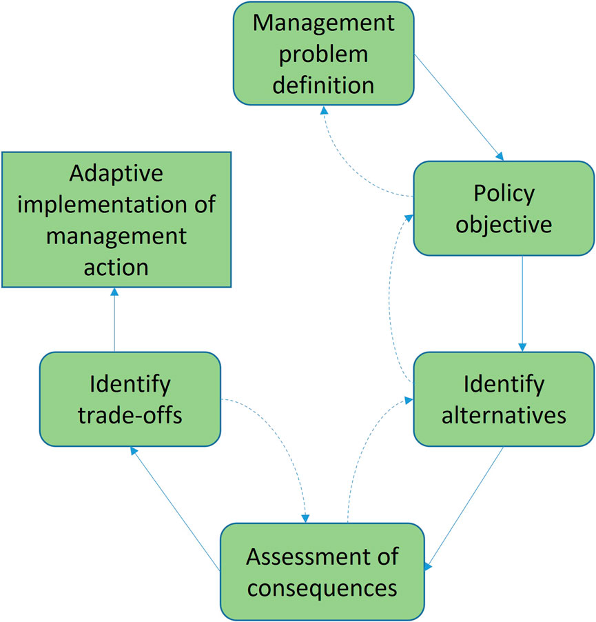
FIGURE 1. Elements in the structured decision-making: The PrOACT (Problem statement, Objectives, Alternatives, Consequences and Trade-offs) sequence (Runge et al., 2020). The dashed lines indicate the element of a decision is not necessarily linear.
Adapting the PrOACT sequence to the analysis of regional cumulative effects, we draw on two tools: the BRAT and ALCES online simulation, which are combined to arrive at an integrated risk and scenario analysis for RA (Figure 2). The BRAT helps to distinguish the value-based elements of the decision (defining the problem context, articulating objectives, and identifying what alternatives are acceptable) from the scientific elements (identifying trade-offs, which alternatives are feasible, and evaluating the consequences), allowing the decision-maker to bring appropriate expertise to help on each element. The BRAT helps to conceptualize the cumulative effects issues, identify potential drivers and impacts, and policies/procedures required to mitigate the possible adverse effects. On the other hand, the ALCES modeling (scientific elements of SDM) demonstrates the potential to link the outcomes of the BRAT into an integrated population dynamic model to explore risks, barriers, and consequences in support of RA. Thus, the BRAT and ALCES become complementary modeling tools that can be implemented to collectively address the information needs of RA (Figure 2). For the purpose of this study, however, we focus only on the BRAT component of the model or framework.
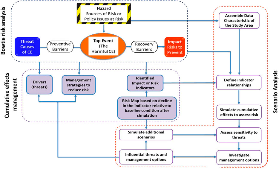
FIGURE 2. Integrated risk and scenario based analysis for regional cumulative effects assessment.
The ISO 31010 BRAT (Figure 3), a risk assessment technique of the ISO 31000 risk management standard (ISO, 2018), is a conceptual model well-suited to environmental assessment (Cormier et al., 2019). The International Organization for Standardization has listed the BRAT as a widely applicable method for the selection and implementation of systematic techniques for risk assessment (IEC/ISO 31010:2009 standard). The BRAT uses pressure-effect-impact pathways to break down complex policy environments and assess risk from any source to any endpoint (Cormier et al., 2018), thus making it suitable for an SDM process. Although BRAT has been applied in several sectors to identify risks, it is only now starting to be applied to the field of environmental management (Elliott et al., 2017; Kishchuk et al., 2018; Winder et al., 2020), particularly to analyze cumulative effects in resource management and the risks of not meeting environmental policy objectives (e.g., Cormier et al., 2019), risks to water quality, and forest management pressures on biodiversity and water quality (Kishchuk et al., 2018). Winder et al. (2020) used the BRAT to evaluate the cumulative effects of anthropogenic and natural factors affecting boreal caribou (Rangifer tarandus caribou) herds in Northeastern British Columbia. BRAT helped to navigate complexity and convey, at the landscape level, the interactive effects of human activities and disturbances (Winder et al., 2020). Importantly, BRAT can help to identify the most effective management strategies to address risks. Thus, BRAT frameworks can provide a clearer understanding of complex cumulative effects problems.
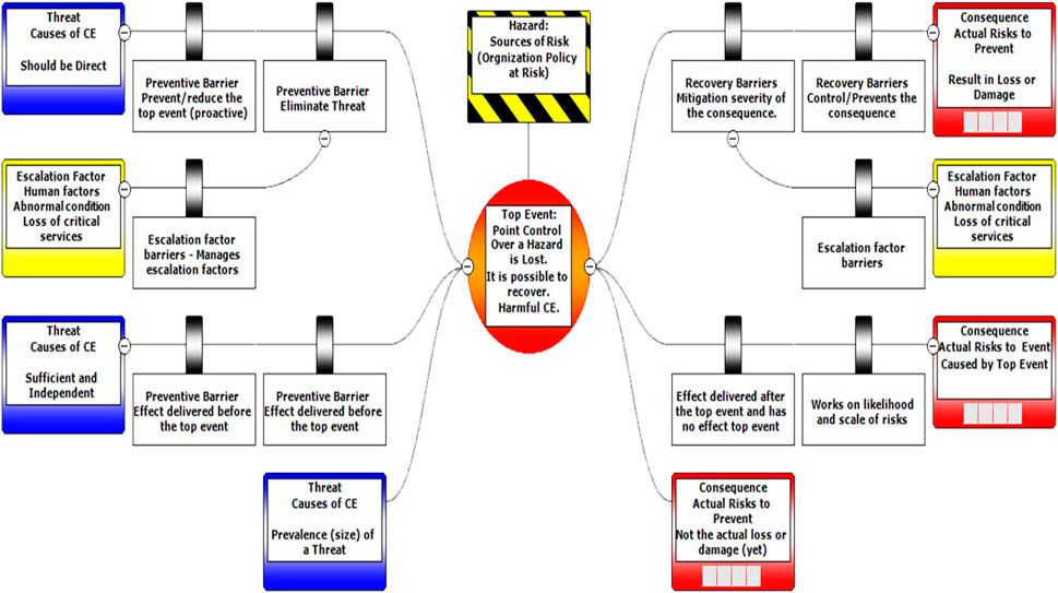
FIGURE 3. Components of a BRAT diagram.
The components of a BRAT diagram are the policy objective at risk (i.e., the hazard); the harmful cumulative effects, or where control over management object is lost (top event); causes of the risk event (threats); consequences of the risk event; preventative barriers that impede the threats from triggering the risk event; and mitigation barriers that reduce the negative consequences of the risk event (Figure 3). Collectively, these components of the bow-tie diagram allow a detailed understanding of policy objectives. The BRAT framework can be used to numerically quantify the effectiveness of risk barriers, quantitatively and qualitatively portray the overall scope of contemporary risks and analyze the deficiencies in management systems. Specifically, the BRAT provides a concise representation of key components such as drivers (i.e., threats), indicators (i.e., consequences), and management scenarios (i.e., barriers). In summary, the BRAT diagram maps how threats can trigger a risk event (ecological tipping point) that violates management objectives and thereby leads to negative consequences (Figure 3). The BRAT also identifies management strategies that can act as barriers to risks by preventing threats from triggering the risk event or mitigating the negative consequences after a risk event.
The value of BRAT also lies in its ability to prompt brainstorming on interdisciplinary issues previously not well considered. Therefore, identifying threats and consequences requires brainstorming sessions, often through workshops that include stakeholders from multiple fields, thus promoting the development of results that minimize technical jargon and can be understood across disciplines (ISO, 2018).
2 Methodology
2.1 Context–The ring of fire region
The study area is the RoF region, which is in the ecologically sensitive James Bay Lowlands of Northern Ontario, Canada, a subset of the Hudson Bay Lowlands which forms part of the second-largest contiguous peatland complexes in the world (Packalen et al., 2014). The area is part of Treaty nine territory, also known as the James Bay Treaty. The study area overlaps with the RoF mineral deposits, First Nation Territories, and multiple caribou ranges The RoF is an approximately 5,120 km2 crescent-shaped area in northern Ontario (52°58′45″N, 86°26′26″W) hosting a collection of multi-element ore deposits (Chong, 2014). It resides on primarily Phanerozoic calcareous bedrock within a humid high boreal climatic zone, with a mean annual temperature between −2.6 and 0°C, a mean growing season between 154 and 173 days, and mean annual precipitation between 528 and 833 mm (Crins et al., 2009).
First Nation communities located in and around the area include the Webequie, Nibinamik, Neskantaga, Marten Falls, and Eabametoong. However, even other geographically distant First Nation over northern and eastern Ontario members may consider the land encompassed by the RoF region as their traditional territory.
The Hudson Bay Lowlands support a wide variety of fauna and flora. This includes at least 816 native and 98 non-native plant species, approximately 300 bird species (predominantly migratory birds), more than 50 species of terrestrial and marine mammals, and at least 35 species of fish (Abraham et al., 2005). Notably, the species hosted by the region include several at-risk species, such as polar bears (Ursus maritimus), woodland caribou (Rangifer tarandus caribou), wolverine (Gulo), lake sturgeon (Acipenser fulvescens), and a variety of birds, e.g., Canada warbler (Cardellina canadensis) (https://www.ontario.ca/page/canada-warbler).
In addition to the RoF mines, other active or planned land uses in the region include timber production, the several planned major and access roads for the RoF, communities, and potential hydroelectric developments (Chetkiewicz and Lintner, 2014). The region’s biophysical attributes make it an interesting location to assess how climate change is affecting wildlife habitat, with the region likely to experience a wide array of climate-related impacts (Chetkiewicz and Lintner, 2014). The region could experience the full range of threats and impacts from the planned developments, thereby requiring a thorough understanding of the potential risks and cumulative effects. The federal government recently mandated a RA under the IAA for the RoF area, with the terms of reference being worked out with the Provincial government and Indigenous communities. In 2020, the federal government, through the Minister of Environment and Climate Change, directed the IAAC to engage with diverse groups, including Indigenous groups, non-government organizations, the Province of Ontario, and other federal departments to discuss appropriate activities, outcomes, and spatial and temporal boundaries for the RA in the RoF. The IAAC proposed that the goal of the RoF RA is “to provide information and analysis regarding future developments in the RoF area and their potential effects to inform and improve impact assessments and other planning and decision-making processes in a way that helps protect the environmental, health, social and economic conditions of the area while also creating opportunities for sustainable economic development” (IAAC, 2020a).
2.2 Research design
The study is guided by Gunn and Noble’s (2009) methodological foundations of regional strategic environmental assessment that required a more regional and integrative approach for RA, underpinned by three core principles, including being strategic, cumulative effects driven and regionally focused. We drew from different sources and approaches to gather information and data for this study in a stepwise direction, including review and adaptation of existing literature (focused on identifying Valued Ecosystem Components related to cumulative effects of resource development). Figure 4 shows each step involved in the research design.
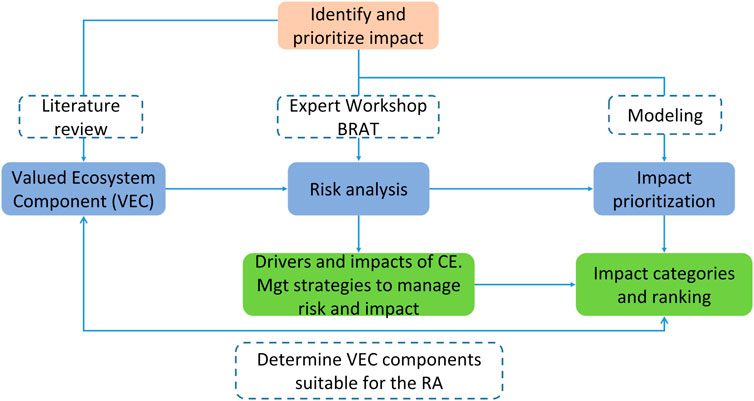
FIGURE 4. Steps involved in the research design.
2.2.1 Identification of valued environmental components
Following Antwi et al. (2022), we identified valued ecosystem components (VECs) that are important to assessment of the impact of mining on ecosystems and people. Since Antwi et al. (2022)’s research was a global review of cumulative effects, we adapted their list of indicators to make it relevant to the Ring of Fire context. Guided by the Cumulative Effects assessment questionnaire developed by Canter and Kamath. (1995) and considering the regional issues of interest to different stakeholders in the Ring of Fire region, we adapted and categorize the VECs according to six major components including organism, biodiversity, land, climate change, fish/wildlife habitat, and water (Table 1). For each VEC, measurable parameters (defined here as sub-VECS) were defined, where possible and appropriate, to facilitate specific quantitative or qualitative measurement of potential project effects and cumulative effects. Measurable parameters provide a means to determine the level or amount of change in a VEC.

TABLE 1. Summary of VEC Components, VECs, and sub-VECs.
In the next stage of analysis, we selected specific sub-VECs and explored them further through a BRAT analysis (Table 2). The selection of the sub-VECs was guided by policy objectives at risk (top-events) in the context of the proposed mining in the RoF area and the expertise of the workshop participants. In all, we focused on 12 top events or policy objectives (see Supplementary Material S1) that guided the BRAT workshop.

TABLE 2. VECs and sub-VECs and relationship to specific policy objectives.
2.2.2 Bowtie risk analysis workshop
Guided by the 12 top events or policy objectives at risks in the context of the RoF area, we conducted a BRAT workshop to help prioritise and identify key regional risks, sources, impacts and mitigation measures. We built on past applications of the BRAT tool in examining a broad range of policy objectives in the context of resource management and applied the BRAT as a problem-solving tool. Discussions during the workshop were open, collaborative, and driven by the experts themselves (i.e., bottom up). Participants focused on identifying priority risks, sources, impacts, and mitigation measures within their areas of expertise. The BRAT expert workshop was convened in November 2020 and involved researchers from different divisions/branches within the Canadian Forest Service (CFS) of Canada’s Department of Natural Resources (NRCan) department and beyond (see Supplementary Material S2 and Supplementary Material S3 for a summary on the background of the participants for the workshop). Prior to the workshop, a summary of the findings from the review of published literature (see Table 1) was shared with the participants. Due to the diverse scientific/technical backgrounds of the participants, the workshop was divided into separate socio-economic and ecological groups. In this paper, we present only the results from the ecological group, although some socio-economic implications associated with the ecological issues remain.
Following the workshop, additional expert consultations or interviews were held with specific subject-matter leads to refine the initial BRAT maps developed for each policy objective and event under the sub-VECs. The results (impacts) from the BRAT were used to develop an impact prioritization model (see Section 2.4) which enabled us to quantify, rank, and prioritized the identified impacts.
2.3 Impact prioritization model and analysis
Using the outcomes of the BRAT workshop, we developed an impact prioritization model and analysis. The impact prioritization model helps to identify impacts that are cross-cutting, multi-sector driven, and synergistic, and thus enables the prioritization of impacts that are of greatest significance to a region and most urgently require effective management and policy intervention. This involves scoring each individual impact (derived from the BRAT analysis) according to nine (9) criteria (see Table 3) guided by previous studies on regional risk assessment approaches and frameworks (see EAO, 2013; Gunn and Noble, 2009; Borgwardt et al., 2019).
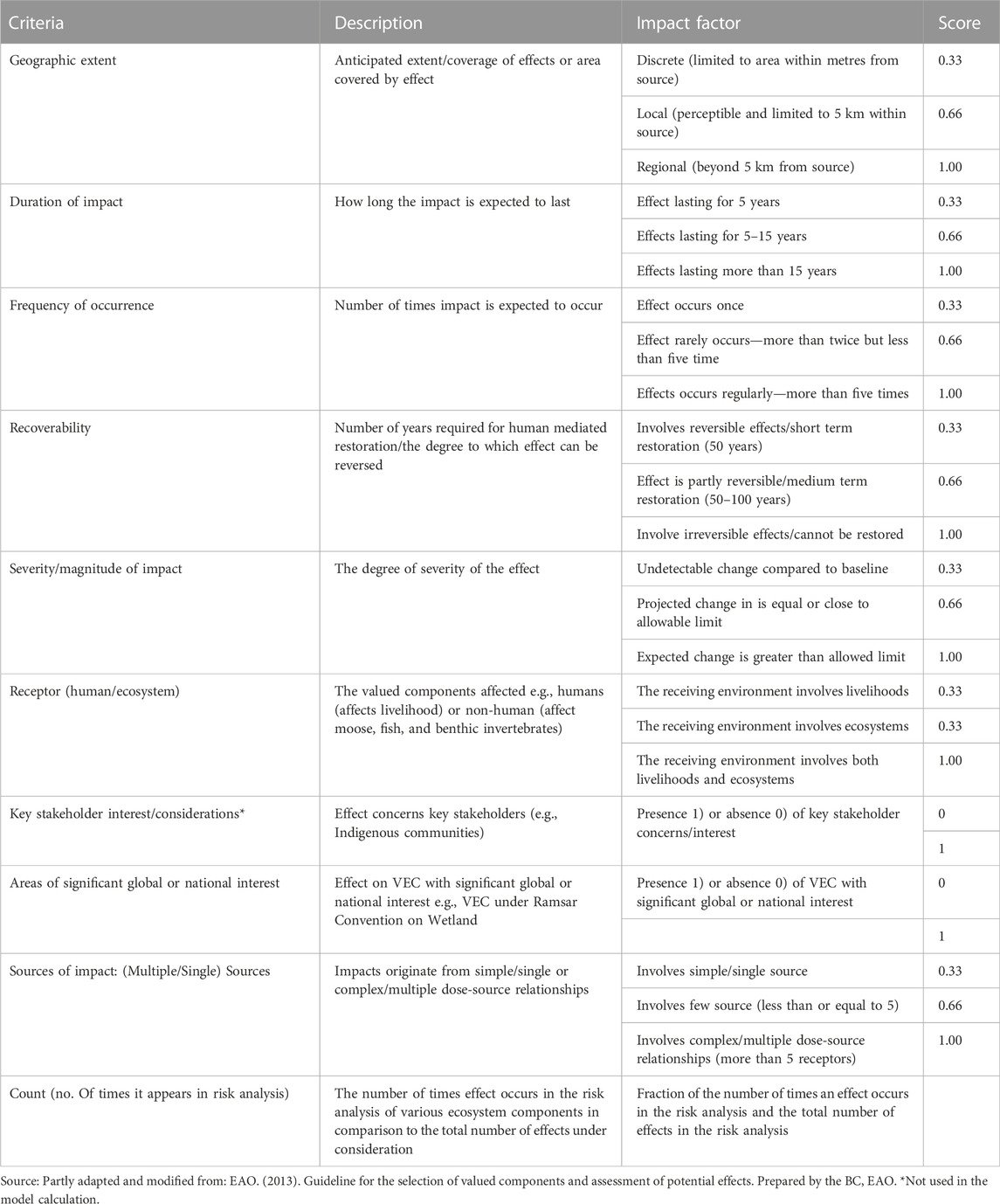
TABLE 3. Criteria for scoring and valuation of impact.
To score the impact of each criterion, the research team debated and discussed the scoring, guided by the literature review. Scores were assigned for each individual impact (1 = high; 0.66 = moderate; and 1 = high). However, in some of the impacts, the scoring was either 1 (present) or 0 (absent or not present). The model is consistent with standard approach to environmental risk assessment that considers impact risk as being composed of exposure to activity, and the consequence of that exposure (e.g., Borgwardt et al., 2019). Thus, for each individual impact, the total exposure is the combined effect of the nine criteria focused broadly on spatial and temporal extent of the exposure, magnitude and frequency of occurrence, recoverability, and others, all of which are not independent of each other. In addition, the consideration of key stakeholder issues (e.g., Indigenous communities) and areas of significant global or national/public interest makes our risk scoring and valuation unique as it extends previous approaches that have largely focused on biophysical criteria for assessment.
2.4 Model calculation
To determine which impacts should be prioritized during decision making, we used Eq. 1 to compute impact numerical values for the individual impacts as follows:
where
3 Results
3.1 Bowtie risk analysis outcomes
Guided by the 12 policy objectives, the BRAT analysis identified various forms of risks and impacts. In total, 62 unique impacts (Table) were identified in the BRAT exercise, which we categorized under four broad impact themes: 1) hydrological related impacts (flow regimes; surface water declines; and lowering of drinking water quality), 2) wildlife related disturbances (migratory bird habitat loss; unsustainable wildlife population; and alteration of baseline noise-causing disturbance to wildlife); 3) habitat and biodiversity related forms of destruction (disruption of habitat connectivity below critical thresholds; successful colonization of non-native species; and negative population growth for species at risk); and 4) soil, air and fire disturbances (soil contamination; declines in air quality; and increase in fire severity and frequency). Below, we describe each category of impacts along with their sources and consequences and indicate the prevention and mitigation measures that were identified to prevent or reduce the magnitude of impacts. Throughout the discussion, although we make distinctions between the direct consequences caused by risks to humans and ecosystems, these are not mutually exclusive as both interact at multiple levels.
3.1.1 Risk analysis related to hydrological disturbances
Under the hydrological disturbances, the top events identified were changes in flow regimes, surface water declines, and lowering of drinking water quality (Figure 5). The common sources of impacts related to the hydrological changes include withdrawal intake for mine-related activities access-road construction in or near waterbodies, adjacent banks, or shores, draining of peatlands, and unsustainable fish populations. Changes in flow regimes can be caused by early snowmelt and reduced snowpack, permafrost thaw, and draining of peatlands. Surface water declines, lowering of drinking water quality, and unsustainable fish population can be caused by wastewater, seepage and storm water runoff from contaminated mine sites, accidental release of toxic substances from mine sites, acidic rainfall and drainage, waste rock and mine tailings release into the water, eutrophication, and leaching of toxic constituents.
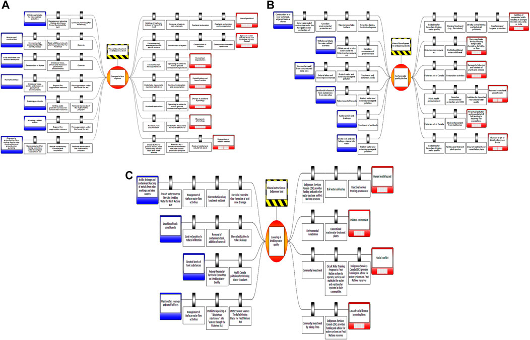
FIGURE 5. Risk Analysis Related to Hydrological-related disturbances in the RoF Area. (A) Flow regimes (B) surface water declines (C) lowering of drinking water quality.
The BRAT workshop also identified the consequences of hydrological disturbances. For instance, changes in flow regimes can result in loss or alteration (due to changes in hydrology) of peatland ecosystems, spikes in water volume flow, permafrost degradation, and destruction of wildlife habitats. Also, declines in surface water or decreased water levels can affect water temperature, chemistry, turbidity, or flow, damage to fisheries and habitats of plants and animals, reduced recreational uses of water, and fish mortality, leading to declining fish populations. In addition, lowering of drinking water quality has a direct consequence on humans as it can be a health hazard, increase social conflict, decrease quality of human life and lead to a loss of social license for mining firms.
Preventive and mitigation measures identified to stop or reduce hydrologically related disturbances from occurring were diverse and included both legislative and management actions. On the preventive side, for instance, to control the occurrence of changing flow regimes, management planning (Mining Act, Crown Forest Sustainability Act), land use planning (Far North Act) and federal and provincial environmental assessment legislation, are activated prior and during the mining. On the direct management side, the construction of dykes and support for regeneration of native trees, shrubs and mosses species in permafrost environments can be used to control soil temperature.
Regarding the mitigation options, several management and legislative approaches were identified to reduce the impacts of the consequences. For instance, to mitigate the impact of lowering drinking water quality, Indigenous Services Canada (ISC) provides funding and advice for water systems on First Nations reserves, while Circuit Rider Training Program also supports First Nations in operating, servicing and maintaining the water and wastewater systems in their communities. In addition, mining companies can be encouraged to provide funding to improve water quality to avoid social conflict.
3.1.2 Risk analysis related to wildlife disturbances
The second category of top events are wildlife related disturbances, include migratory bird habitat loss; unsustainable wildlife populations; and alteration of baseline noise and light. Common disturbances across these top events include the construction of mines and supporting infrastructure, causing increased light and sound pollution (e.g., cumulative impacts of shovelling, ripping, drilling, blasting, crushing, grinding, and stockpiling); removal of soil and vegetation around nesting sites and breeding grounds; and increased contact with humans and vehicles. In addition, unsustainable wildlife populations can be caused by excessive wildlife harvest from an influx of people, habitat fragmentation, and changes in predator/prey dynamics.
On the other hand, the consequences for wildlife related disturbances are categorized into impacts on wildlife and on humans. For the former, consequences include increased competition for food, alteration of birds’ nesting habitat, disturbance of migratory bird nests or eggs, disruption of migratory pathways, increased hunting leading to direct migratory bird mortality, extirpation, or extinction, cascading impacts to other wildlife, declining genetic fitness, and wildlife sensory disturbance. Also, increased presence of humans on primary roads can cause increased physiological and nutritional stress of caribou (Wasser et al., 2011). For the human related disturbances, loss of social license for development, increases in human-wildlife conflict and reduced access to country food by Indigenous people are possible second-order consequences of wildlife disturbance.
To prevent wildlife-related disturbances from occurring beyond unacceptable thresholds, preventive measures under several laws such as the Species at Risk Act (e.g., limiting human contact and protecting critical habitat of species at risk), Migratory Birds Convention Act (e.g., protecting areas frequented by migratory birds), Environmental Protection Act and The Planning Act of Ontario (e.g., activate set Noise Pollution Control Guidelines) can be used. In addition, the 2019 Canadian Fisheries Act which has specific legislative provisions for the protection of fish and fish habitat including pollution prevention and regulations for deleterious substances to fish and the invasive species, can be applied. Also, noise-related disturbance to wildlife can be controlled through the installation of noise monitoring stations and the implementation of avoidance strategies such as planning drilling outside of the nesting season, while disturbances from light can be prevented by implementing downward facing and fully shielded outdoor light fixtures, installing light monitoring stations and motion sensors, and implementing dark sky laws and ordinances (e.g., mandating downward-pointing lighting fixtures).
To reduce the severity of these impacts, mitigation programs supported by legislation can be implemented. Specific legislation that can be applied include the Environmental Protection Act and The Planning Act of Ontario (e.g., activate Noise Pollution Control Guidelines), and the Fish and Wildlife Conservation, Act and the Migratory Birds Convention Act. Under these laws, specific management mitigation mechanisms to reduce the impact on wildlife and humans can be implemented. Figure 6.
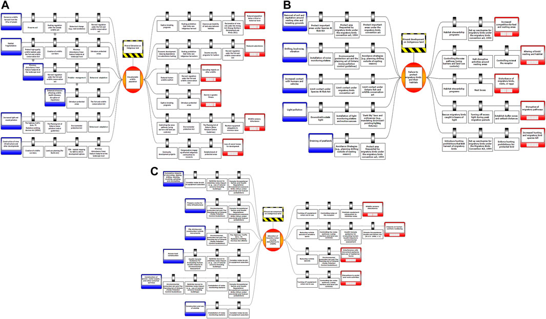
FIGURE 6. Risk Analysis Related to Wildlife disturbances. (A) Unsustainable wildlife population (B) migratory bird habitat loss (C) alteration of baseline noise-causing disturbance to wildlife.
Captive breeding and habitat stewardship programs, harvest regulations, the introduction of protected areas, controlling the noise pathway (using barriers and land-use controls), maintaining equipment adequately to minimize noise, halting disruptive activities around nesting areas, rescuing migratory birds trapped in beams of light, establishing buffer zones and setback distances, and enforcing hunting prohibitions for protected species can mitigate impacts to species. On the other hand, mitigation measures that reduce impacts on humans include hunting prohibitions that limit non-Indigenous, especially recreational harvest, economic diversification beyond subsistence hunting, income security programs for hunters, and providing compensation to affected Indigenous communities.
3.1.3 Risk analysis related to habitat and biodiversity disturbance
The third top events category is focused on habitat and biodiversity related forms of destruction, which includes disruption of habitat connectivity below critical thresholds; successful colonization of non-native species; and population decline for species at risk (Figure 7). Across these top events, the most common sources of impacts are destruction of vegetation and habitat from mining infrastructure development, including access roads; increases in the volume and extent of plant and wildlife harvest, including illegal harvesting; and increased movement of humans and materials (e.g., trade, transportation, tourism, and recreation) with potential associated impacts such as the introduction of non-native and invasive species. Other sources of impacts such as climate change, especially warming resulting in mild winters, can also promote the successful colonization of non-native species and negative population growth of species at risk.
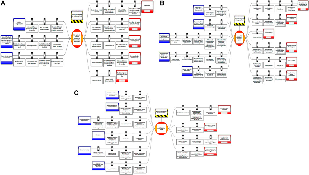
FIGURE 7. Risk Analysis Related to habitat and biodiversity disturbances. (A) Disruption of habitat connectivity below critical thresholds (B) successful colonization of non-native species (C) failure to protect species at risk.
The consequences of habitat and biodiversity-related impacts include hydrology disruption (leading, e.g., to tree mortality caused by the extremes such as local droughts on one hand, and flood resulting in “drunken forests” on the other hand), the spread of exotic and invasive species leading to competition with native species for food and habitat decreased native habitat area and restricted species movement and gene flow, reductions in tree seedling establishment, loss of habitat, and increased parasitism of native species. Overall, high-level consequences include reduction in ecosystem resilience and economic damages.
The preventive and mitigation barriers for habitat and biodiversity related impacts are underpinned by specific legislations. The key legislative preventive barriers include the Fish and Wildlife Conservation Act (e.g., to protect wildlife, establish wildlife corridors, and introduce buffers to prevent the impact of forest edge), the Canada Wildlife Act (e.g., to preserve areas critical for connectivity), the Far North Act (e.g., to control road development/network and manage landscape planning, including minimizing disturbance (e.g., linear features) footprint at landscape level), and the Fish and Wildlife Act (e.g., prohibiting alteration and destruction of fish habitat, establishing fisheries quotas and prohibitions against transportation, possession, importation, and release of non-native species). In addition, other important and applicable legislation can include the Species at Risk Act (e.g., to protect critical habitat and prevent disturbance to residences of species at risk), the Animal Health Act (e.g., restricting movement of agents capable of spreading disease), Forest Fire Prevention Act (e.g., Fire suppression measures), and Plant Protection Act and Canada Shipping Act (e.g., regulating ballast water management).
There are both legislative and management mechanisms that can mitigate impacts to habitat and biodiversity. Regarding legislation, the Weed Control Act (e.g., for population control), Animal Health Act, Pesticides Act and Recreational Fishing and Hunting Regulations (e.g., to regulate recreational fishing/hunting), Fisheries Act (e.g., population control of non-native hosts), and Far North Act (e.g., to reduce the number of new mines and exploration activities) provide several opportunities to reduce potential impacts on habitat and biodiversity related issues.
In terms of management mechanisms, programs such as early detection of new invaders, rapid response procedures to manage new and established invasive species (e.g., through containment, eradication, and control), market restrictions, and introduction of human-mediated restoration measures to improve habitat condition for native species can be implemented to address specific issues. Moreover, habitat restoration programs such as reforestation projects, including the restoration of critical habitats, funding the creation of refuge areas for displaced wildlife, and introduction of wildlife corridors to improve connection across landscape could be implemented to mitigate impacts.
3.1.4 Risk analysis related to air, soil, and fire
The fourth and final category of top events are related to air, soil, and fire disturbances, including soil contamination; declines in air quality; and increases in fire severity and frequency (Figures 8A–C). Potential causes of air pollution can result from emissions from heavy vehicles used in excavation operations and to transport personnel, and from aircrafts; combustion of fuels in power generation installations and drying/roasting operations; and dust from driving and mining operations. On the other hand, soil contamination includes releases or spills of chemical contaminants from vehicle and equipment maintenance areas into the soil; deposition of arsenic, lead, and radionuclides; windblown dust; and salt from roadways. Also, an increase in fire severity and frequency can result from increased incidence of arson and accidental fires that get out of control, e.g., campfires, ignition along roads, and railways, and improper burning of debris.
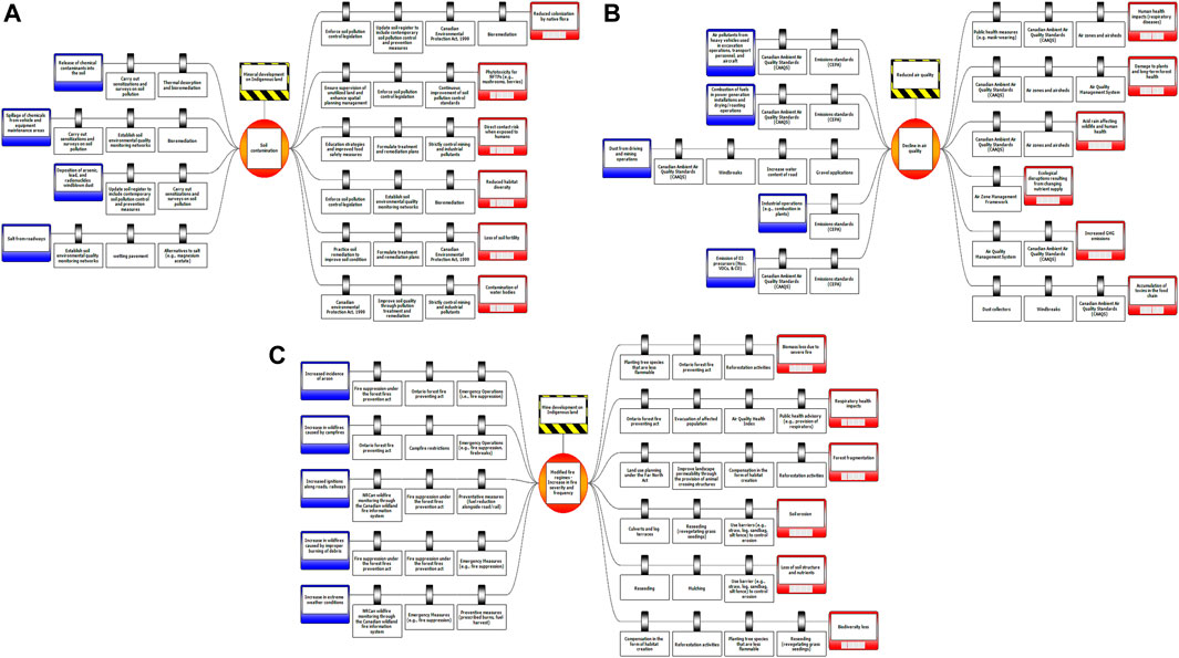
FIGURE 8. Risk Analysis Related to soil, air and fire disturbances. (A) Soil contamination (B) decline in air quality (C) increase in fire severity and frequency.
The consequences of decline in air quality impact both ecosystems (e.g., damage to plants and long-term forest health, increased GHG emissions in the long-term causing intensification of extreme weather events and altering rainfall cycle and acid rain) and human health (e.g., respiratory diseases, and accumulation of toxics in the food chain). On the other hand, the consequences of increased fire severity and frequency include impacts on vegetation (e.g., biomass, loss forest fragmentation, soil erosion and loss of soil structure and nutrients, and species mortality) and on humans (e.g., respiratory-related illness, and loss of property). Soil contamination can affect habitat availability/suitability.
Preventative mechanisms to address the potential increase in fire severity and frequency include activating protection mechanisms under the Forest Fires Prevention Act (e.g., undertake Emergency Operations such as fire suppression and erecting firebreaks), and Ontario Forest Fire Preventing Act (e.g., restrict and control campfire, fuel reduction alongside road/rail, prescribed burns, fuel harvest). Other preventive measures such as early detection and monitoring of wildfire through the NRCan wildfire monitoring under the Canadian wildland fire information system can also be implemented.
Prevention mechanisms to control declines in air quality fall under two main programs, the Canadian Ambient Air Quality Standards (CAAQS) and Emissions standards (CEPA), which can be used to monitor activities to ensure that thresholds for ambient air are not exceeded. Also, specific prevention management mechanisms to prevent lowering of ambient air quality include the introduction of windbreaks and increasing the water content of road and gravel applications. Finally, prevention mechanisms for soil contamination need to focus on early detection through monitoring by carrying out sensitizations and surveys of soil pollution, establishing soil environmental quality monitoring networks, thermal desorption, and bioremediation, updating the soil register to include contemporary soil pollution control and prevention measures, and using alternatives to salt to control ice on roads (e.g., magnesium acetate or gravel).
To mitigate the decline in air quality, the enforcement of CAAQS and implementation of the Air Zone Management Framework and Air Quality Management System (e.g., establish Air zones and airsheds), especially in emission monitoring, would be critical. In addition, direct mitigation measures such as installing dust collectors and windbreaks, as well as issuing public health measures (e.g., mask-wearing), especially when safe thresholds are exceeded, would be key to ensure that human health is not compromised. To mitigate the consequences of increased frequency and severity of fire, public health advisories (e.g., provision of respirators and evacuation of affected population) can be issued, especially when Air Quality Health Indices are exceeded. Also, to restore ecosystems from fire destruction, planting native tree species that are less flammable, large scale reforestation activities and compensation in the form of habitat creation and reseeding could be helpful. To address soil contamination, mitigation measures can focus on enforcement of soil pollution control legislation under the Canadian Environmental Protection Act (Canadian Environmental Assessment Agency, 2018) (e.g., updating soil register to include contemporary soil pollution control and prevention measures, and the establishment of soil environmental quality monitoring networks); supervision of unutilized land and enhancing spatial planning management under the Far North Act; implementation of direct mitigation measures such as improving soil quality through pollution treatment and remediation; and general education strategies to improve food safety.
Having discussed each of the top events through the BRAT analysis, the next step is to rank and prioritise the impacts with the most occurrences and regional impacts to aid decision making.
3.2 Impact score and ranking
The BRAT analysis resulted in 62 unique impacts across the top12 events. The rank of the value of each impact is the value of the impact score compared with all other impacts. Hence, the impact with the highest value is given the highest priority (high rank), and the one with the lowest value is given the least priority (low rank).
Impacts that recorded the highest ranked scores can be organized into three categories as shown in Table 4. These are human related impacts, especially livelihoods of Indigenous peoples (e.g., loss of food sharing networks, reduced subsistence, loss of social licence, accumulation of toxins in the food chain, impacts on human comfort/wellbeing), climatological impacts (e.g., intensities and frequency of extreme weather events), and ecosystem impacts (e.g., extirpation or extinction, forest fragmentation, alterations in food web and community structure increased competition for food and nesting areas).
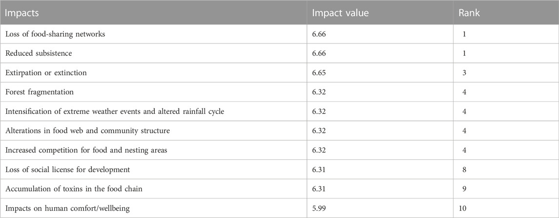
TABLE 4. Ten highest ranked impacts.
Table 5 shows that the ten least ranked impact scores are: phytotoxicity for Non-Timber Forest Products (e.g., mushrooms, berries), followed by restricted species movement and gene flow, competition with native species for food and space, loss of soil fertility, disturbance to migratory birds nesting sites/eggs, acid rain affecting human health, increased parasitism of native species, spikes in water volume flows, degradation, and hydrology disruption (drunken forests).
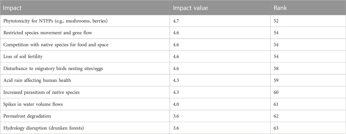
TABLE 5. Ten least-ranked impacts.
In addition to the ranking of individual impacts from the BRAT analysis, the cumulative impacts of each of the 12 major impacts categories or top events (Table 6) were analysed. Destruction of wildlife habitat/population scored the major impact with a score of 40.82 and ranked 1, followed by loss of plant diversity (score 39.53, rank 2), habitat loss/alteration (score 38.83, rank 3), species invasion (loss of native species) (score 37.85, rank 4), and decline in human health and wellbeing (score 36.88, rank 5). On the other hand, some of the lowest ranked value impact categories were heightened tensions/disputes with communities (score 11.63, rank 13), climate variability (score 11.98, rank 12), and disruptions in food chain and web (score 12.98, rank 11).
TABLE 6. Cumulative impacts of each of the major impacts categories.
4 Discussion
The discussion section is divided into two. The first component focuses on the implications of the research for regional cumulative effects assessment and management while the second component focuses on lessons learnt from the development and application of RAFCE for current and future regional cumulative effects assessment.
4.1 Implications for regional cumulative effects assessment and management
Ecological systems are highly complex and variable, and our knowledge about them is incomplete; nevertheless, decisions concerning natural resource management must be made in spite of this uncertainty (Runge et al., 2020). At present, there is little practical guidance available to support risk assessment in the context of natural resource management (Gunn and Noble, 2009, 2011), suggesting a need to define and develop a comprehensive framework to guide practices.
Our study provides a structured approach to regional risk assessment to help managers make decisions involving risk carefully and transparently and clarifying the interlinked roles of scientific information and values. This research developed a structured framework to guide regional environmental risk assessment. The RAFCE involves three overarching steps: identification of regional VECs and sub-VECs; a BRAT workshop and analysis on key region-specific risks, impacts and mitigation measures; and our newly developed impact prioritization model that helps prioritize key impacts for monitoring (Antwi and Wiegleb, 2008), assessment, and effective cumulative effects management. Throughout the paper, we demonstrated the application of this framework to assess the impact of the proposed mining in the RoF region in northern Ontario, Canada. However, RAFCE could be applied in multiple contexts and for different resource developments or disturbances beyond mining. The case application enabled us to describe links caused by the impacts of mining on terrestrial ecosystem components and socioeconomic and health impacts. Our approach is relevant to the operationalization of regional assessment within the framework of the Impact Assessment Act of Canada of 2012 as it lends support to the decision-making needs of environmental managers by providing a flexible, problem-solving solution linking human activities and ecosystem components (Piet et al., 2017; Borgwardt et al., 2019). The framework helps to understand the pathways through which human activities affect VECs and vice versa which can help manage understand impacts of pressures on terrestrial ecosystems with linkages to socioeconomic issues. For instance, the impact rankings identified the highest impact across all major impact categories to include loss of food-sharing networks and reduced subsistence, specie extirpation or extinction, forest fragmentation, intensification of extreme weather events and altered rainfall cycle and alterations in food web and community structure. Others include increased competition for food and nesting areas, loss of social license for development, accumulation of toxins in the food chain and impacts on human comfort/wellbeing.
Our framework and findings can also support assessment and management of cumulative effects, either at the project level or preferable at the regional level (Noble et al., 2017). Assessment of cumulative effects is primarily an attempt to describe environmental change imposed by forces far larger than any one project (Hegmann and Yarranton, 2011). In Canada, while assessment of cumulative effects at the project level is less desirable, often project proponents are expected to do this non-etheless based on existing federal and provincial legislations (Noble et al., 2017). For instance, while project-based CEA is driven by project approval as opposed to broader understanding of sustainability of VCs affected by the project, proponents also often fail to identify and manage the impacts of activities of other land and resource users (Duinker and Greig, 2006; Boutilier and Black, 2013) as they focus on few VCs, and their indicators based on ecological significance, public or cultural value, or regulatory requirements (Canter and Kamath, 1995). However, by grounding our assessment through an SDM approach and guided by holistic assessment criteria, our framework provides the needed baseline knowledge and collective understanding to support the assessment and management of regional and project level cumulative effects. For instance, the highest ranked impacts could be used to support individual project level assessments by making them non-negotiable VECs for project level assessment (cf. Noble et al., 2017). Finally, RAFCE through the BRAT also enabled a consistent identification and linking of ecological changes to past, present, and future social issues in cumulative effects assessment. Understanding cumulative social change requires a knowledge of the functional relationships between project-induced change and the legacy effects of previous development (Weber et al., 2012; Noble et al., 2017).
4.2 Lessons learned
In this section, we reflect on the main utilities of our approach, referencing lessons learned from the RoF case study. Specifically, we discuss four important implications of the framework; namely, its capacity to: 1) facilitate knowledge exchange and co-creation; 2) identify VECs and indicators for RA; 3) identify policy and management options for impact mitigation; and 4) promote cost-effective natural resource management.
4.2.1 Facilitation of knowledge exchange and co-creation
In the course of assessing proposed mining in the RoF region, the construction of BRAT diagrams enabled subject matter experts from various disciplines to work together to identify ramifications of mine development, operation, and management; as well as brainstorm relevant legislation, management procedures, and other approaches to address potential adverse effects of mining. The logical structure of the BRAT, supported by an intuitive visual representation, helped these scientific experts understand and thus effectively contribute to the risk assessment process.
There is broad consensus that many environmental problems span scientific disciplines and require interdisciplinary thinking to identify risks and formulate policy and management responses (Binder et al., 2013; Pricope et al., 2019). Our approach explicitly calls for cross-disciplinary collaboration in defining risks, their causes, and preventative and mitigation measures. Specifically, the BRAT workshop is geared towards facilitating knowledge co-creation on issues that require interdisciplinary knowledge synthesis, with the construction of BRAT diagrams serving as a structured task on which to focus the collaborative efforts of experts from different fields. These diagrams serve as clear summaries of the outcomes of a BRAT workshop that can be shared with different audiences, thereby enhancing the transparency of the risk assessment process. As such, our approach responds to calls for increased opportunities for “debate, collaboration, creativity [and] learning” during cumulative effects assessment (Jones, 2016).
Beyond integrating knowledge from different technical and scientific experts, as was done in this research, future BRAT workshops could include different regional stakeholders, such as Indigenous groups, local communities, and regional/local resource managers. As noted by Gallagher et al. (2015), early and comprehensive stakeholder engagement improves the outcomes of risk assessment, especially when dealing with cumulative effects, which, given the multitude of issues involved, are likely to implicate a wide array of perspectives. With the participation of key regional stakeholders, the BRAT workshop could, at its best, help illuminate key regional issues, spurring consensus building on topics that need to be addressed in a RA. Through the engagement of stakeholders, our process would be better able to facilitate “exposure to different world views and consideration of the distribution of power” during assessment, as called for by Jones. (2016).
Notably, the inclusion of Indigenous stakeholders in such processes is consistent with the Government of Canada’s commitment to reconciliation with Indigenous peoples and with the aims of RAs under Canada’s IAA, which emphasizes the need to understand and help manage issues that have the potential to impact Indigenous peoples and their rights. By using BRAT to guide RA, there is a distinct opportunity to engage, collaborate or establish partnerships with Indigenous peoples early in the risk assessment process to help promote alignment between the objectives and outcomes of risk assessment with Indigenous interests, knowledge, and perspectives. More importantly, the use of a BRAT to engage Indigenous rightsholders and experts in RA could help operationalize the concept of Two-Eyed Seeing; a concept often emphasized by Indigenous Peoples as effective to weaving together Indigenous ways of knowing and western knowledge systems in RA. However, the involvement of Indigenous people in BRAT processes must be done in a manner that respects Indigenous self-capacity and promotes adequate representation of Indigenous Peoples and their views to help reduce power imbalances.
4.2.2 Identification of valued environmental components and indicators
Supported by such interdisciplinary participation, the framework described in this paper can be applied to help identify VECs and indicators for RA. Cumulative effects are typically assessed based on indicators of the condition of VECs (effects-based) or of sources of stress to VECs (stressor-based) (Ball et al., 2013). The definition of VECs and indicators is highly consequential for RA, as it determines what will actually be measured and evaluated during the assessment. The process of deciding on VECs and indicators to analyse can be based on professional input, or through more inclusive processes that solicit the views of regional stakeholders (Jones, 2016). In either case, a robust and inclusive process should be employed to inform VEC and indicator development to ensure that the outcomes of the RA are meaningful.
Our framework employs an iterative process that starts with a literature review to identify key VECs, which then inform a BRAT workshop aimed at facilitating focused input from different experts or stakeholders, and finally a model to prioritize key regional impacts. The outcomes of the BRAT process can then inform more targeted and relevant VECs to the regional context and stakeholder concerns. Beyond the BRAT outcomes, the prioritization model, building off the outcomes of the BRAT, evaluates the significance of identified impacts based on quantitative criteria. Outputs of the overall process include the identification of key risk sources and priority impacts of concern in a region. We believe that these risk sources and prioritized impacts–being informed by expert and/or stakeholder input (BRAT) and robust qualitative (literature review) and quantitative (impact prioritization) methods–are suitable to directly inform the selection of indicators to evaluate during RA. The identification of indicators can, in turn, elucidate the kind of data that is needed, where to source data from, and at what stage of RA the data is needed. For example, Table 7 demonstrates the conversion of risk sources to indicators and highlight some of the uncertainties (the type and availability of scientific data) that needs to be considered in risk analysis (see Gissi eft al, 2017). The type(s) of data needed to measure the indicator and the stage in the risk assessment process at which the indicator needs to be measured are also indicated.
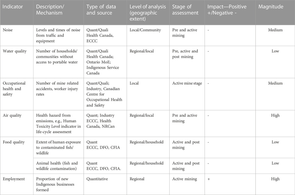
TABLE 7. Data types, sources and analysis for indicators derived from BRAT diagrams.
4.2.3 Identification of policy and management options
Another important attribute of our approach is its emphasis on identifying management systems and policies to prevent or mitigate impacts (Table 8). Namely, for each risk source or consequence identified, the BRAT facilitates the identification of management or policy options that can be used to prevent the risk or mitigate adverse consequences. Amid the multi-sectoral, cross-boundary, and multi-stakeholder demands involved in natural resource management, the BRAT can inform vertical policy integration (i.e., among local/municipal, regional, provincial, and federal levels) and promote coherence among different policies and management approaches implemented in various situations (Cormier et al., 2019).

TABLE 8. Examples of management systems and policies to prevent and mitigate impacts.
In the case of proposed mine development in the RoF region, the BRAT provided a transparent and structured approach to identify the existing legislation, policies, and regulatory regimes that could mitigate or prevent risks and anticipated consequences of mine development (cf. Cormier et al., 2019). By incorporating all of these elements into the regional risk assessment process, RAFCE enabled the full suite of legislation, regulations, policies, standards, procedures and guidelines relevant to the RoF to be elucidated in a manner that highlights their collective capacity to serve as a barrier to pressures. Thus, our approach of incorporating preventive and mitigation barriers goes beyond the static pressure-state-consequences pathway model, and can, in turn, illuminate the knowledge and capacity required to operationalize the outcomes of risk assessment effectively. For concerned or interested stakeholders and or rightsholders, the identification of mitigation and preventive barriers in the risk management process can promote transparency and provide an assurance that proponents of the resource development are aware and taking steps to address risks.
The policy and management options identified in the BRAT can also form the basis of subsequent quantitative analyses geared towards evaluating regional risks through simulation exercises. For example, as our overall framework in Figure 2 illustrates, the outcomes of the BRAT can serve as inputs for scenario analysis using the ALCES online simulation. While the BRAT analysis helps to conceptualize cumulative effects issues, the ALCES online simulation enables scenario analysis options to integrate landscape and population simulators to obtain a holistic representation of drivers and impacts of cumulative effects across large spatial and temporal scales.
4.2.4 Efficient and effective resource management
Finally, RAFCE can help prioritize issues to ensure that limited resources are used cost-effectively. Given that natural resource policy and management must address multiple and diverse human activities that cause pressures, many policy and management responses are required to address traditional, cultural, social, ecological, technical, and economic policy objectives. The application of the BRAT exercise to proposed mining in the RoF region illustrated that the impacts of mining on ecological VECs are multiple and complex and can be overwhelming from a policy and management perspective. To ensure effective and efficient policy and management response, including resource allocation to address impacts, an impact prioritization model was developed and implemented. The model provides a quantitative element to the prioritization of impacts based on multiple scoring criteria, including geographic extent, duration of impact, frequency of occurrence, recoverability, magnitude of impact, receptor (human/ecosystem), key stakeholder interest, significant global or national interest and source(s) of impact. The outcomes of the impact prioritization model can be used to inform the scoping of issues during RA, as well as prioritize policy and management actions towards high-risk impacts. In this context, the model can support efficient and effective resource allocation both in assessing and addressing impacts.
In the RoF case study, the top five impacts with the highest ranked scores were: disturbance to migratory bird habitat and nesting sites, followed by wildlife sensory disturbance, restricted species movement and gene flow, acid rain affecting human health, and alteration/elimination of fish habitats. These prioritized impacts can inform scoping of the RA for the RoF, as well as broader decision-making in the region.
4.3 Gaps and next steps
While the framework described in this paper followed a robust process with several important applications for regional environmental risk assessment, we note three key caveats to guide understanding and evaluation of our methods and framework analysis. First, the identification of issues in the BRAT analysis and impact scoring relied extensively on technical and scientific expert opinion from individuals employed in academic and government institutions. Hence, future applications of the BRAT should engage local stakeholders and rightsholders, most notably Indigenous communities, in order to elucidate interests beyond those of the scientific community. Ideally, to encourage transdisciplinary thinking and knowledge co-creation, both experts and community stakeholders could work together to identify regional risk issues. Collaboration between experts and regional stakeholders is likely to enrich the outcomes of the BRAT exercise by allowing multiple values and diverse perspectives to inform the identification of regional issues of concern (Gallagher et al., 2015).
Second, our approach to regional environmental risk assessment involves several methodological steps that emphasize subjective decisions (Gasparatos et al., 2008; Singh et al., 2017). The use of qualitative expert judgment to brainstorm risk issues and score impacts without actual data, given the absence of sensitivity analysis, reduces the replicability of our results. To limit such methodological shortcomings and when field data is involved, future analyses could use principal component, factor, and/or distance analyses to target normalization and address these limitations (Singh et al., 2017). These limitations notwithstanding, the use of an SDM approach to ground RAFCE, combined with several robust and transparent steps, help enhance the utility of our approach.
Finally, our case study on the RoF focused predominantly on adverse ecological impacts of mining with some consideration for direct social, economic, and human health issues. While the effects of mining on ecological VECs are near-uniformly negative, the implications of natural resource development with regard to the socioeconomic conditions in local communities are often highly nuanced and complex (Ensign et al., 2014). Although RAFCE did not address socioeconomic valued components in depth in the RoF region, we stress that our framework can be adapted to address the socioeconomic impacts of mining and could also be adapted to differentiate negative and positive impacts. Future application of our framework can also incorporate uncertainty analysis to support decision makers in a more structured way beyond the identification o potential adverse effects we adopted. Analysis of uncertainty needs to verify that these conditions are satisfied: i) the potentially adverse effects are identified, ii) the availability of scientific data is evaluated, and iii) the extent of scientific uncertainty is analyzed (Gissi et al., 2017).
5 Conclusion
RA continues to grow in the impact assessment literature across different world regions, although tools, methods, and best practices to support regional risk assessment are scarce. To achieve progress, frameworks need to be developed to address complex issues such as integrating legal and regulatory issues, interdisciplinary knowledge, and value-based aspects of the decision analysis to support real-world natural resource management decisions. This research develops a risk and impacts-based cumulative effects assessment framework for scoping regional cumulative effects issues and analyzes and supports scenario planning to guide present and future regional cumulative effects assessment. By operationalizing the framework to assess the risks posed by mining in the RoF region of northern Ontario, we learned that this structured process provides a careful and transparent approach to risks assessment, helps to identify and prioritize risks of regional importance, and enables linkages between science and policy to promote effective management. The framework can be applied to assess the risk and impacts of different natural resource development, visualize the risks management process, identify policy and management issues, determine feasible interdepartmental collaboration to address cross-cutting issues, identify skills and capacity gaps and areas of resource allocation and the implications for sustainable regional development in the context of decision support for regional cumulative effects assessment.
Data availability statement
The original contributions presented in the study are included in the article/Supplementary Material, further inquiries can be directed to the corresponding author.
Author contributions
EKA: Conceptualization, development or design of methodology; creation of models, writing—original draft, visualization, supervision, JB-D: Conceptualization, design of methodology; writing—original and final draft preparation. WO-B: Conceptualization, design of methodology; review and editing. AD: Conceptualization; writing—original draft preparation IE: Conceptualization; writing—reviewing and editing. DAS: Conceptualization; writing—reviewing and editing. BE: Conceptualization, design of methodology; review and editing. EA: writing—reviewing and editing. RW: Conceptualization, reviewing and editing.
Funding
The Cumulative Effects Program of the Canadian Forest Service-Natural Resources Canada funded this research. The Cumulative Effects Program of Canadian Forest Service-Natural Resources Canada did not play any role in preparing this manuscript.
Acknowledgments
The Canadian Forest Service Cumulative Effects Program supported this work. David Nanang envisioned the need for RAFCE. We want to thank DG Danny Galarneau, director Tracey Cooke, mentor Sonja Kosuta, manager Katalijn MacAfee, Sara Ryan, and Matthew Wheatley for their immense support and encouragement throughout this study. Their suggestions improved the manuscript. The following research scientists contributed to the Bowtie Risk Assessment workshops; Nicolas Mansuy, Sara Ryan, Camille Ouellet-Dallaire, Kara Webster, Eric Neilson, Erik Emilson, Philip Wiebe, Jason Leach, Lisa Venier, Heather Macdonald, Joanne De Montigny, Aurelia Thevenot, Lindsay Galway, Colleen George, Cheryl Chetkiewicz, and Stephen Mayor.
Conflict of interest
The authors declare that the research was conducted in the absence of any commercial or financial relationships that could be construed as a potential conflict of interest.
Publisher’s note
All claims expressed in this article are solely those of the authors and do not necessarily represent those of their affiliated organizations, or those of the publisher, the editors and the reviewers. Any product that may be evaluated in this article, or claim that may be made by its manufacturer, is not guaranteed or endorsed by the publisher.
Supplementary material
The Supplementary Material for this article can be found online at: https://www.frontiersin.org/articles/10.3389/fenvs.2022.1055159/full#supplementary-material
References
Abraham, K. F., and Keddy, C. J. (2005). “The Hudson Bay lowland,” in The world’s largest wetlands: Ecology and conservation (Cambridge, UK: Cambridge University Press), 118–148.
Antwi, E. K., Boakye-Danquah, J., Owusu-Banahene, W., Webster, K., Dabros, A., Wiebe, P., et al. (2022). A Global review of cumulative effects assessments of disturbances on forest ecosystems. J. Environ. Manag. 317, 115277. doi:10.1016/j.jenvman.2022.115277
Antwi, E. K., and Wiegleb, G. (2008). “Standards and indicators for monitoring impact of disturbance on biodiversity in a post-mining area using GIS,” in Standards and thresholds for impact assessment (Berlin, Heidelberg: Springer), 277–290.
Ball, M. A., Noble, B. F., and Dubé, M. G. (2013). Valued ecosystem components for watershed cumulative effects: An analysis of environmental impact assessments in the south Saskatchewan River Watershed, Canada. Integr. Environ. Assess. Manag. 9 (3), 469–479. doi:10.1002/ieam.1333
Beaufort Environmental Assessment Plan [BSStRPA] (2008). Beaufort Sea strategic regional plan of action (2004–2008). Available at: https://beaufortrea.ca/resource/beaufort-sea-strategic-regional-plan-of-action-2004-2008/.
Binder, C. R., Hinkel, J., Bots, P. W., and Pahl-Wostl, C. (2013). Comparison of frameworks for analyzing social-ecological systems. Ecol. Soc. 18 (4), art26. doi:10.5751/es-05551-180426
Blakley, J., Noble, B., Vella, K., Marty, J., Nwanekezie, K., and Fedoroff, K. (2020). Lessons learned, best practices and critical gaps in regional environmental assessment: A synthesis of Canadian and international literature. Canada: Humanaties Research Council Canada.
Borgwardt, F., Robinson, L., Trauner, D., Teixeira, H., Nogueira, A. J., Lillebø, A. I., et al. (2019). Exploring variability in environmental impact risk from human activities across aquatic ecosystems. Sci. Total Environ. 652, 1396–1408.
Boutilier, R. G., and Black, L. (2013). Legitimizing industry and multi-sectoral regulation of cumulative impacts: A comparison of mining and energy development in Athabasca, Canada and the Hunter Valley, Australia. Resour. Policy 38 (4), 696–703.
Bower, S. D., Brownscombe, J. W., Birnie-Gauvin, K., Ford, M. I., Moraga, A. D., Pusiak, R. J., et al. (2018). Making tough choices: Picking the appropriate conservation decision-making tool. Conserv. Lett. 11 (2), e12418. doi:10.1111/conl.12418
Bunnefeld, N., Hoshino, E., and Milner-Gulland, E. J. (2011). Management strategy evaluation: A powerful tool for conservation?. Trends Ecol. Evol. 26 (9), 441–447.
Canadian Environmental Assessment Agency (2018). Assessing cumulative environmental effects under the Canadian environmental assessment act. Available at: https://www.canada.ca/en/impact-assessment-agency/services/policy-guidance/assessing-cumulative-environmental-effects-ceaa2012.html.
Canter, L. W., and Kamath, J. (1995). Questionnaire checklist for cumulative impacts. Environ. Impact Assess. Rev. 15 (4), 311–339. doi:10.1016/0195-9255(95)00010-c
Chetkiewicz, C., and Lintner, A. (2014). Getting it right in ontario's Far North-the need for a regional strategic environmental assessment in the ring of fire (wawangajing). Working paper.
Chong, J. (2014). Resource development in Canada: A case study on the ring of fire. Ottawa, ON: Library of Parliament, 19.
Cook, C. N., Inayatullah, S., Burgman, M. A., Sutherland, W. J., and Wintle, B. A. (2014). Strategic foresight: How planning for the unpredictable can improve environmental decision-making. Trends Ecol. Evol. 29 (9), 531–541.
Cormier, R., Elliott, M., and Rice, J. (2019). Putting on a bow-tie to sort out who does what and why in the complex arena of marine policy and management. Sci. Total Environ. 648, 293–305. doi:10.1016/j.scitotenv.2018.08.168
Cormier, R., Stelzenmüller, V., Creed, I. F., Igras, J., Rambo, H., Callies, U., et al. (2018). The science-policy interface of risk-based freshwater and marine management systems: From concepts to practical tools. J. Environ. Manag. 226, 340–346. doi:10.1016/j.jenvman.2018.08.053
Crins, W. J., Gray, P. A., Uhlig, P. W. C., and Wester, M. C. (2009). “The ecosystems of Ontario, Part 1: Ecozones and ecoregions,” in Ontario ministry of natural resources (Peterborough: Ontario, Inventory, Monitoring and Assessment).
Duinker, P. N., and Greig, L. A. (2006). The impotence of cumulative effects assessment in Canada: Ailments and ideas for redeployment. Environ. Manage. 37 (2), 153–161.
EAO (2013). Guideline for the selection of valued components and assessment of potential effects. Victoria, BC: BC Environmental Assessment Office Government of BC.
Elliott, M., Burdon, D., Atkins, J. P., Borja, A., Cormier, R., De Jonge, V. N., et al. (2017). And DPSIR begat DAPSI (W) R (M)!”-a unifying framework for marine environmental management. Mar. Pollut. Bull. 118 (1-2), 27–40. doi:10.1016/j.marpolbul.2017.03.049
Ensign, P. C., Giles, A. R., and Oncescu, J. (2014). Natural resource exploration and extraction in Northern Canada: Intersections with community cohesion and social welfare. J. Rural Community Dev. 9 (1), 112–133.
Francis, S. R., and Hamm, J. (2011). Looking forward: Using scenario modeling to support regional land use planning in northern Yukon, Canada. Ecol. Soc. 16 (4), art18. doi:10.5751/es-04532-160418
Gallagher, S. S., Rice, G. E., Scarano, L. J., Teuschler, L. K., Bollweg, G., and Martin, L. (2015). Cumulative risk assessment lessons learned: A review of case studies and issue papers. Chemosphere 120, 697–705. doi:10.1016/j.chemosphere.2014.10.030
Gasparatos, A., El-Haram, M., and Horner, M. (2008). A critical review of reductionist approaches for assessing the progress towards sustainability. Environ. Impact Assess. Rev. 28 (4–5), 286–311.
Gissi, E., Menegon, S., Sarretta, A., Appiotti, F., Maragno, D., Vianello, A., et al. (2017). Addressing uncertainty in modelling cumulative impacts within maritime spatial planning in the Adriatic and Ionian region. PLoS ONE 12 (7), e0180501. doi:10.1371/journal.pone.0180501
Gregory, R., Failing, L., Harstone, M., Long, G., McDaniels, T., and Ohlson, D. (2012). Structured decision making: A practical guide to environmental management choices. Chichester, United Kingdom: John Wiley & Sons.
Gunn, J. H., and Noble, B. F. (2009). Integrating cumulative effects in regional strategic environmental assessment frameworks: Lessons from practice. J. Env. Assmt. Pol. Mgmt. 11 (03), 267–290. doi:10.1142/s1464333209003361
Gunn, J., and Noble, B. F. (2011). Conceptual and methodological challenges to integrating SEA and cumulative effects assessment. Environ. Impact Assess. Rev. 31 (2), 154–160. doi:10.1016/j.eiar.2009.12.003
Gunn, J., and Noble, B. F. (2012). Critical review of the cumulative effects assessment undertaken by Manitoba Hydro for the Bipole III project. Winnipeg, MB: Prepared for the Public Interest Law Centre.
Hegmann, G., and Yarranton, G. T. (2011). Alchemy to reason: Effective use of cumulative effects assessment in resource management. Environ. impact Assess. Rev. 31 (5), 484–490. doi:10.1016/j.eiar.2011.01.011
Hodgson, E. E., Halpern, B. S., and Essington, T. E. (2019). Moving beyond silos in cumulative effects assessment. Front. Ecol. Evol. 7, 211. doi:10.3389/fevo.2019.00211
IAAC (2022). Regional assessment in the ring of fire area. Available at: https://iaac-aeic.gc.ca/050/evaluations/proj/80468.
IAAC (2020b). Regional assessment of offshore oil and gas exploratory drilling east of Newfoundland and labrador. Available at: https://iaac-aeic.gc.ca/050/evaluations/proj/80156.
ISO (2018). ISO 31000:2018 Risk management—Principles and Guidelines. Available at: https://infostore.saiglobal.com/en-au/search/standard/?sortkey=date-desc&publisher=as&productfamily=standard Standards Australia.
Johnson, D., Lalonde, K., McEachern, M., Kenny, J., Mendoza, G., Buffin, A., et al. (2011). Improving cumulative effects assessment in Alberta: Regional strategic assessment. Environ. Impact Assess. Rev. 31 (5), 481–483. doi:10.1016/j.eiar.2011.01.010
Jones, F. C. (2016). Cumulative effects assessment: Theoretical underpinnings and big problems. Environ. Rev. 24 (2), 187–204. doi:10.1139/er-2015-0073
Kishchuk, B. E., Creed, I. F., Laurent, K. L., Nebel, S., Kreutzweiser, D., Venier, L., et al. (2018). Assessing the ecological sustainability of a forest management system using the ISO Bowtie Risk Management Assessment Tool. For. Chron. 94 (1), 25–34. doi:10.5558/tfc2018-005
Manitoba Government and Manitoba Hydro (2015). Regional cumulative effects assessment for hydroelectric developments on the churchill, burntwood and Nelson River systems phase II report, Part II hydroelectric project description. Avaliable At: https://www.hydro.mb.ca/docs/regulatory_affairs/pdf/rcea/rcea_phase2_part_ii_hydroelectric_de velopment_project_description.pdf.
Margules, C. R., and Pressey, R. L. (2000). Systematic conservation planning. Nature 405 (6783), 243–253. doi:10.1038/35012251
Noble, B., Liu, J., and Hackett, P. (2017). The contribution of project environmental assessment to assessing and managing cumulative effects: Individually and collectively insignificant? Environ. Manag. 59 (4), 531–545. doi:10.1007/s00267-016-0799-7
Packalen, M. S., Finkelstein, S. A., and McLaughlin, J. W. (2014). Carbon storage and potential methane production in the Hudson Bay Lowlands since mid-Holocene peat initiation. Nat. Commun. 5 (1), 4078–8. doi:10.1038/ncomms5078
Piet, G. J., Knights, A. M., Jongbloed, R. H., Tamis, J. E., de Vries, P., and Robinson, L. A. (2017). Ecological risk assessments to guide decision-making: Methodology matters. Environ. Sci. Policy 68, 1–9. doi:10.1016/j.envsci.2016.11.009
Pricope, N. G., Cassidy, L., Gaughan, A. E., Salerno, J. D., Stevens, F. R., Hartter, J., et al. (2019). Addressing integration challenges of interdisciplinary research in social-ecological systems. Soc. Nat. Resour. 33 (3), 418–431. doi:10.1080/08941920.2019.1680783
Rempel, R. S., Carlson, M., Rodgers, A. R., Shuter, J. L., Farrell, C. E., Cairns, D., et al. (2021). Modeling cumulative effects of climate and development on moose, wolf, and caribou populations. J. Wildl. Manage. 85 (7), 1355–1376. doi:10.1002/jwmg.22094
Runge, M. C., Converse, S. J., Lyons, J. E., and Smith, D. R. (2020). Structured decision making: Case studies in natural resource management. Baltimore, MD: Johns Hopkins University Press.
Schneider, R. R., Stelfox, J. B., Boutin, S., and Wasel, S. (2003). Managing the cumulative impacts of land uses in the western Canadian sedimentary basin: A modeling approach. Conserv. Ecol. 7 (1), art8. doi:10.5751/es-00486-070108
Schwartz, M. W., Cook, C. N., Pressey, R. L., Pullin, A. S., Runge, M. C., Salafsky, N., et al. (2018). Decision support frameworks and tools for conservation. Conserv. Lett. 11 (2), e12385. doi:10.1111/conl.12385
Singh, G. G., Sinner, J., Ellis, J., Kandlikar, M., Halpern, B. S., Satterfield, T., et al. (2017). Mechanisms and risk of cumulative impacts to coastal ecosystem services: An expert elicitation approach. J. Environ. Manage. 199, 229–241.
Sullivan, M. G. (2009). Cumulative effects assessment of the North Saskatchewan River watershed using ALCES. AvaliableAt: http://nswa.ab.ca/cumulative_effects.
Sutherland, W. J., Pullin, A. S., Dolman, P. M., and Knight, T. M. (2004). The need for evidence-based conservation. Trends Ecol. Evol. 19 (6), 305–308.
Walters, C. J. (1986). Adaptive management of renewable resources. New York, NY: Macmillan Publishers Ltd.
Wasser, S. K., Keim, J. L., Taper, M. L., and Lele, S. R. (2011). The influences of wolf predation, habitat loss, and human activity on caribou and moose in the Alberta oil sands. Front. Ecol. Environ. 9 (10), 546–551. doi:10.1890/100071
Weber, M., Krogman, N., and Antoniuk, T. (2012). Cumulative effects assessment: Linking social, ecological, and governance dimensions. Ecol. Soc. 17 (2), 22. doi:10.5751/es-04597-170222
Keywords: regional assessment, cumulative effects, bowtie risk analysis, impact, resource development, decision support analysis, framework, management
Citation: Antwi EK, Boakye-Danquah J, Owusu-Banahene W, Dabros A, Eddy IM, Silver DA, Abolina E, Eddy B and Winder RS (2023) Risk assessment framework for cumulative effects (RAFCE). Front. Environ. Sci. 10:1055159. doi: 10.3389/fenvs.2022.1055159
Received: 27 September 2022; Accepted: 07 December 2022;
Published: 24 January 2023.
Edited by:
Salvador García-Ayllón Veintimilla, Technical University of Cartagena, SpainReviewed by:
Mohammad Yazdi, Macquarie University, AustraliaLinda Kay Silka, University of Maine, United States
Roland Cormier, Fisheries and Oceans Canada (DFO), Canada
Copyright © 2023 Antwi, Boakye-Danquah, Owusu-Banahene, Dabros, Eddy, Silver, Abolina, Eddy and Winder. This is an open-access article distributed under the terms of the Creative Commons Attribution License (CC BY). The use, distribution or reproduction in other forums is permitted, provided the original author(s) and the copyright owner(s) are credited and that the original publication in this journal is cited, in accordance with accepted academic practice. No use, distribution or reproduction is permitted which does not comply with these terms.
*Correspondence: Effah Kwabena Antwi, effah.antwi@canada.ca, effah.antwi@nrcan-rncan.gc.ca