Spatiotemporal differences of land use pattern between mountainous areas and basin areas at township scale: A case study of Yuxi City
 Li Wu
Li Wu Jing Zhou1
 - 1College of Geography and Land Engineering, Yuxi Normal University, Yuxi, China
- 2School of Geographic Sciences, Hunan Normal University, Changsha, China
- 3German Research Center for Geosciences (GfZ), Potsdam, Germany
- 4College of Urban Planning and Architecture, Xuchang University, Xuchang, China
Land use/land cover change is an important carrier for the study of human-land relationship. Yuxi City is a typical area of with alternating mountain and basin landforms, forming a special human-land system with “mountains” and “basins” as the core elements. Taking 75 towns in Yuxi City, Yunnan Province as a case study, this paper uses a comprehensive evaluation model of land use/land cover change and related analysis methods to analyze the changes of land use pattern in mountainous areas and basin areas respectively from 1995 to 2018, and to reveal their spatial differences and its influencing factors. The results show that: 1) The dynamic evolution of land use in the mountainous area and the basin area presented obvious stage characteristics. From 1995 to 2005, the average comprehensive dynamic degree of land use in the mountainous area was 1.7861, which was significantly higher than the 1.7033 in the basin area. The average comprehensive dynamic degree of land use in mountainous areas from 2005 to 2018 was 1.1284, which was significantly lower than 1.9427 in the basin area. 2) From 1995 to 2018, the land use degree and the comprehensive dynamic degree of land use continued to rise in the basin area, while the mountainous area showed a trend of rising first and then falling. The overall change trend of land use depletion in the mountainous area was consistent with that in the basin area, but the mountainous area was always higher than that in the basin area. 3) The land use change in mountainous areas and basin areas was mainly reflected in the difference of natural factors and socio-economic fators. The radiation and agglomeration functions of the basin area have always attracted people to migrate from the mountains to the basin, which was beneficial to the ecological restoration of the vegetation in the mountains. Since the mountainous area and the basin area are geographically adjacent, the coupling and coordination of the two is the premise and foundation for the sustainable development of the region. This causal relationship of land use changes provides a reliable basis for the regulation of mountain-basin human-land coupling relationship.
1 Introduction
As an important carrier of social and economic development and human activities (Smiraglia et al., 2015), land resources utilization change can not only reflect the spatio-temporal change characteristics of regional land use, but also reflect the influence of natural and human factors on its long-term effects, representing the spatio-temporal change of natural and human factors and reflecting the coupling relationship between human and land (Gondwe et al., 2019; Olorunfemi et al., 2020). With the increase of human activities and climate change, the land use/land cover has undergone great changes and become a core issue of major international research projects (Xie et al., 2021). Land use/land cover change is an important source of information for understanding the complex interactions between human activities and the ecological environment, which helps to protect and manage related resources, solve the dilemma of current decision-making among land, water, energy and food sectors, and improve human well-being and ecological security (Wolde et al., 2021; Parven et al., 2022). At present, the dynamic change analysis of land use mainly uses the land use/land cover data interpreted by remote sensing images, and they have been used to analyze the temporal and spatial evolution process and pattern of land use/land cover (Kumar et al., 2021; Matlhodi et al., 2021), and to understand and analyze the driving force, change speed and pattern of land use/land cover change from different research scales (Isufi and Berila, 2021; Twongyirwe et al., 2022). In recent years, with the continuous improvement of urbanization level and the change of population quantity and spatial distribution structure, the problems of resource environment and ecological security brought by land use change have become increasingly prominent (Hou et al., 2022; Siddik et al., 2022). At present, discussing the dynamic change process of land use from the perspective of coupling between human activities and the natural environment, and the dynamic change law of land use (Solomon et al., 2020) as well as its impact on the environment and ecology (Meer and Mishra, 2020; Msofe et al., 2020; Yang et al., 2022) from different levels is the focus of many scholars. However, it should be pointed out that, this kind of research results mainly came from the sociallly and economically developed areas (Guo et al., 2009; Lu et al., 2019), the ecologically environment fragile zones (Zhou et al., 2016; Zhao et al., 2018), and the urban fringe areas (Yang et al., 2011; Cui et al., 2013; Li et al., 2018). But there are relatively few studies on mountainous areas, especially from the perspectives of “mountain” and “basin” sub-regions, which have not attracted enough attention and formed a significant research system.
The sustainable management of mountainous areas has aroused considerable interest in recent decades and occupied a prominent space in the international debates on regional sustainable development. Mountainous areas are an important carrier for ecosystem services and biodiversity maintenance (Schild, 2008), as well as an ecological barrier for regional socio-economic development (Scheurer and Jost, 2012). However, with the advancement of urbanization, mountainous areas have gradually become marginal and conflicting areas of economic development (Schild and Sharma, 2011). The conflicts between the fragility characteristics of mountain ecosystems and high-intensity human activities have led to problems such as ecological degradation, economic backwardness, and population poverty (Kohler and von Dach, 2015; Ma et al., 2018; Zhang et al., 2020), confronting the sustainable development of mountainous areas great challenges. The unsustainability faced by mountainous areas is mainly due to the land use against the natural laws. With the growth of the population, when the output of plain farmland cannot meet the food demand, human beings have no choice but to go to the mountains to reclaim the relatively barren land (Zhang et al., 2016; Buchner et al., 2020). However, the over-exploitation of mountain land will bring a series of negative ecological effects such as soil erosion (Feng et al., 2010; Nguyen et al., 2022). From another perspective, the current urbanization development strategy has accelerated the labor migration and flow from mountainous areas to the basin areas, which reduces the human disturbance of the mountain land, and further drives the significant transformation of land use. For example, the cultivated land in the mountainous area is transformed into forest and grassland, and the conversion of the cultivated land in the basin area is further accelerated, resulting in a series of socio-economic and ecological environmental responses (Zhang et al., 2018; Zhang et al., 2020).
In the terrestrial landscape system of China, the generalized mountain landscape accounts for two-thirds. Due to the invasion and influence of human activities, the characteristic human-earth system with “mountain” and “basin” as the core elements has been formed, and then constitutes an important and unique natural-human geography unit, which has become an important content of the scientific research of the human-earth system. However, for a long time, comprehensive geographical studies on mountainous/basin areas have mainly focused on natural landscape differentiation (e.g., macroscopic classification or vertical differentiation rules of mountain-basin, etc.) (Fang et al., 2021) or the development of medium-macro scale planning (e.g., territorial space development at provincial and municipal scales, etc.) (Song et al., 2021). The results have played an important role in supporting the precise spatial governance and the decisions correlation of regional sustainable development. With the refinement of regional development policies and the development of nature-human geography, there is an urgent need to strengthen the micro-scale refinement research, especially the research on the variation of factors between “mountains” and “basins” and the coupling evolution of land use in a broad sense. Thus, more scientific and precise strategies will be provided for the rural revitalization, mountainous area development, spatial governance, and ecosystem service maintenance and improvement.
Yuxi City is located in the mountainous area of southwest China, with typical mountain-basin landform characteristics (Wu and Xie, 2019). The basin area is flat, suitable for farming and construction, and is an important carrier of human economic activities, while the natural conditions in the mountainous area are complex and difficult to use (Meybeck et al., 2001; Li et al., 2014; Liu and Li, 2020). However, the mountainous area and the basin area are adjacent in the region, which makes the coupling relationship between them exist in the land use evolution. Therefore, based on the divided mountain-basin types in Yuxi City at the township scale (Wu et al., 2020a), the differences in land use changes between mountainous areas and basin areas in Yuxi City at different time periods were discussed to reveal the differential laws of land use changes. According to the correlation analysis method, the influencing factors of land use difference changes were analyzed respectively, so as to provide some references for the difference analysis on the land use coupling evolution relationship between mountainous areas and basin areas.
2 Materials and methods
2.1 Materials
2.1.1 Regional overview
Yuxi City is located at the central part of Yunnan Province, on the Yunnan Plateau at low latitudes, with a subtropical plateau monsoon climate, ranging from 23°19′ to 24°53′ north latitude and 101°16′ to 103°09′ east longitude (Figure 1). Yuxi is located at the core position of Yunnan Province, connecting the east to the west and the north to the south. It is not only an important hub of an “international channel”, but also a strategic “hinterland” of Yunnan Province facing Southeast Asia and South Asia. The city has a land area of 15,285 km2 and has jurisdiction over 75 townships (towns and streets) in seven counties and two districts. The main landform in the west is the deep-cut high mountain and valley landform, the central and eastern part belongs to the mountainous area of central Yunnan, and is dominated by the mid-mountain landform, the eastern region is mainly composed of the plateau lake basin landforms, and the terrain in the basin is flat and open. At the end of 2018, the total permanent population of Yuxi City was 2.386 million, of which the urban population was 1.238 million and the rural population was 1.148 million, with an urbanization rate of 51.9%.
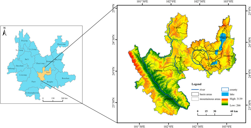
FIGURE 1. Location of study area.
2.1.2 Data sources
The data of land use/land cover used in the study consists of two parts. The first part is the research data of dynamic change in land use, which is mainly obtained by interpretating six Landsat remote sensing images in Yuxi City from 1995 to 2018. It mainly includes Landsat five TM images, Landsat seven ETM + images and Landsat eight OLI images, which are obtained from the geospatial data cloud website (www.gscloud.cn). Based on ArcGIS 10.8 software, the maximum likelihood classification method was used to classify land use/land cover (Richards, 1995), which was divided into six categories: cultivated land, forest land, grassland, water body, construction land and unused land. According to the research needs, forest land and grassland were combined into forest and grassland. A total of six periods of land use/land cover data of Yuxi City from 1995 to 2018 were obtained (Figure 2). The second part is the driving force analysis data of land use change, including land use survey data and social and economic data. The land use survey data came from the survey data of Yuxi City over the years. The socio-economic data were obtained from the Statistical Yearbook of Yunnan Province from 1996 to 2019, the Statistical Yearbook of Yuxi City from 1995 to 2018, and the statistical yearbook of each county and district of Yuxi City from 1995 to 2018.
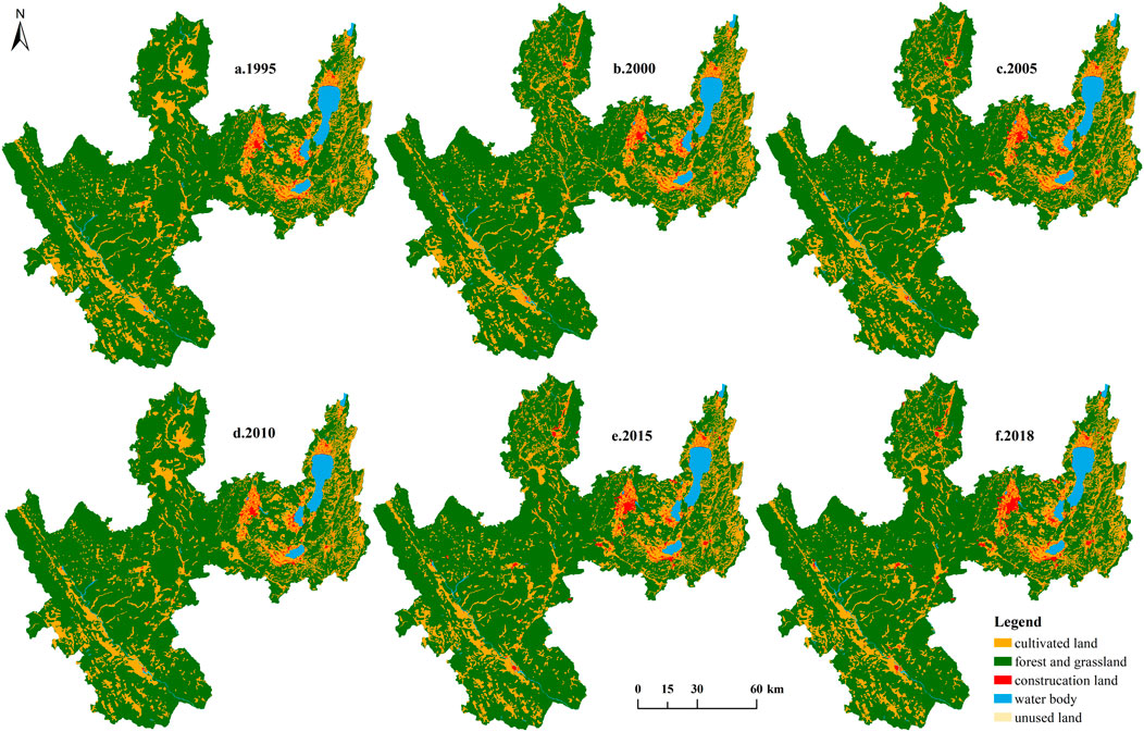
FIGURE 2. Interpretation of land use type in Yuxi City from 1995 to 2018.
2.2 Methods
2.2.1 Land use degree
The land use degree can reflect the breadth and depth of land use (Zhuang and Liu, 1997). In this study, the comprehensive index of land use degree was used as an index to measure the land use degree, and its calculation formula is as follows:
Where, La is the comprehensive index of land use degree, Ai is the grading index of the ith land use type, Ci is the area percentage of the ith land use type, and n is the number of land use types. In this paper, the natural and humanistic attributes of land are comprehensively considered, and the land use types are combined and reorganized into four categories, which are further divided into four levels according to the land use degree and endowed with corresponding grading indexes (Table 1).
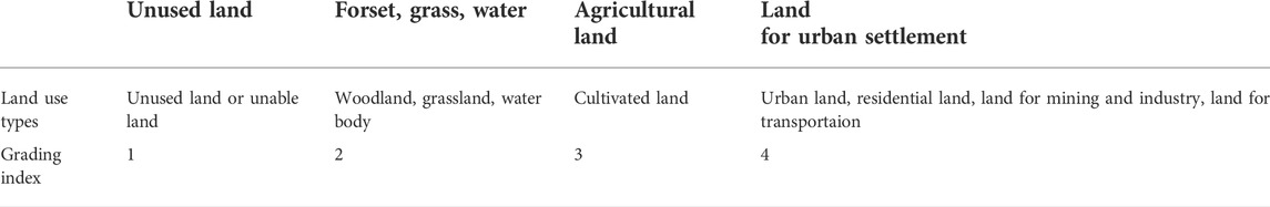
TABLE 1. Land use degree classification index.
2.2.2 Land use change speed
The speed of land use change can be reflected by the model of comprehensive dynamic degree of land use (Wu et al., 2014). Comprehensive dynamic degree of land use refers to the overall speed of land use change in a region, and its calculation formula is as follows:
Where, LC is the comprehensive dynamic degree of land use, LUi is the area of class i land use type at the beginning of the study period, ΔLUi-j is the area of transformation from class i to class j at the end of the study period, and T is the study duration.
2.2.3 Land use consumption degree
Land use consumption degree represents the actual consumption degree of a certain land use type per unit time (Lu et al., 2007), and its calculation formula is as follows:
Where, LCU is the reduction degree of a certain land use type during the study period, Cab is the total area of a certain land use type that transformed into other land use types from time a to time b, Ua is the area of this land use type at time a, and T is the study duration.
2.2.4 Land use transfer matrix
The changes in the transfer and outflow of various land classes during the study period can be reflected by the land use transfer matrix, and the transfer direction at the beginning of maturity and the transfer source at the end of the term can also be understood (Lu et al., 2007). Its mathematical model is as follows:
Where, S is the area of the land class, n is the number of land use types, i and j are the land use types at the beginning and end of the study period respectively.
3 Land use dynamic differences between mountainous and basin areas
3.1 Land use structure and degree change
The land use in the mountainous area and basin area of Yuxi City is dominated by forest, grassland and cultivated land, but the cultivated land, construction land and water body in the basin area are significantly more than those in the mountainous area. The cultivated land accounts for 15–16% in the mountainous area while 20–23% in the basin area. The total water area, construction land and unused land do not exceed 30% of the total area of the mountainous area or basin area. The proportion of the cultivated land, water area and construction land in the basin area is more than 20, 10 and 6% respectively, which are significantly higher than that in the mountainous area (15, 1.5 and 2%). From 1995 to 2018, the proportion of the construction land in mountainous areas was 2–3%, and that in basin areas increased from 5.00 to 9.43%. The proportion of the cultivated land in the mountainous area was 15–16%, while the proportion of the cultivated land in the basin area is decreased significantly from 23.80 to 20.75%. The comprehensive index of land use degree in the basin area increased from 227.25 to 233.78, and that in the mountainous area increased from 213.67 to 214.49, and then decreased continuously to 214.09 in 2018. That is, the land use degree in the basin area continued to rise, while in the mountainous area, it increased first and then decreased, with a small change range (Figure 3A). From 1995 to 2018, the urbanization level of the basin area increased from 15.65 to 58.26%. The increase of urban population led to the continuous expansion of construction land, and the occupation of the unused land, forest and grassland, and cultivated land, which improved the land use degree continuously. On the contrary, in mountainous areas, although the area of construction land increased to some extent, the abandonment of arable land and the natural restoration of forest and grassland contributed to a large amount of natural ecological space and reduced the land use degree.
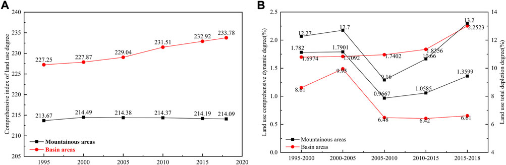
FIGURE 3. Land use dynamic changes in mountainous areas and basin areas of Yuxi City from 1995 to 2018.
3.2 Land use comprehensive dynamic degree change
The comprehensive dynamic degree of land use in the basin area rose from 1.6974 in 1995 to 2.2523 in 2018, with an increase of 33%. The comprehensive dynamic degree change of the land use in mountainous areas showed a characteristics of stage change. During the study period, the comprehensive dynamic degree decreased from 1.782 to 1.3599, but the overall trend was in the shape of an “S” (Figure 3B), including three stages, the slight rise stage (1995–2005), the sharp decline stage (2005–2010) and the continuous rise stage (2010–2018). The comprehensive dynamic degree of the land use in the slight rise stage was higher than that in the basin area, while in the latter two stages, the dynamic degree of the land use in the basin area was higher than that in the mountainous area. In comparison, the land use change in the mountainous area was more severe than that in the basin area from 1995 to 2005, while the change in the land use of the basin area from 2005 to 2018 was more severe than that in the mountainous area. The main reason was that with the continuous improvement of urbanization level, the population in the mountainous area migrated to the basin area, and the intensity of human activities weakened in the mountainous area while increased in the basin area.
3.3 Land use consumption change
From 1995 to 2018, the overall consumption of land use in mountainous areas first increased from 12.27 to 12.70, then decreased to the lowest, with the value of 9.16, and then continued to rise. From 2015 to 2018, it significantly increased to a peak value of 13.20, with an increase of 44.10% (Figure 3B). The change range of land use consumption in the basin area is small, with a peak of 9.95 from 2000 to 2005, and then a slow decline. Compared with the mountainous area in the same period, the increase range was only 2.01%. In general, there was an obvious trend of stage change of the overall land use reduction degree in mountainous areas and basin areas, with a change pattern of “rise-down-rise”. The construction land consumption degree in the mountainous area in the last three stages reached 3.79, 6.97 and 19.00 times of that in the basin area, respectively, and the gap showed a trend of further widening trend. The main reason was that the increase of population density and urbanization level in the basin area increased the demand of land. Due to the difference of natural conditions, the large area of water in Yuxi City is mainly located in the basin area, mainly three lakes, the water area is large and the variation is small, while the area of water in the mountainous area is small and varies greatly under the influence of annual precipitation. The migration of population from mountainous areas to the basin area, the consolidation of the rural residential areas, demolition and so on greatly reduced the amount of construction land.
3.4 Land use transfer change
From 1995 to 2018, land transfer in mountainous areas mainly occurred between the cultivated land and the forest and grassland, and the transfer amount of other land types was relatively small (Figure 4). The main direction of the cultivated land transfer in and out in each stage was forest and grassland. From 1995 to 2018, the area of the cultivated land converted to forest and grassland was 86,800 hm2, accounting for 90.78% of the total area of cultivated land transferred out. The area of the forest and grassland which was converted to the cultivated land was 79,881 hm2, accounting for 47.37% of the total area of forest and grassland transferred out. The transfer-in and transfer-out directions of the construction land are the cultivated land and the forest and grassland, and the transfer amount in the latter two stages was significantly higher than that in the first three stages. From 2010 to 2015 and from 2015 to 2018, the total area of the cultivated land converted to the construction land was 5,838 hm2, accounting for 72.48% of the total amount of the cultivated land which was converted to construction land during the study period. In the same period, the conversion amount from construction land to forest, grassland and cultivated land reached 9,112 hm2, accounting for 53.23% of the total amount of conversion from construction land to forest, grassland and arable land during the study period. The main transfer sources and destinations of the unused land were the forest and grassland and cultivated land, but the conversion of unused land to forest and grassland and cultivated land continued to decline. From 1995 to 2000, the area of the unused land converted to the cultivated land and forest and grassland reached an average of 1,611 hm2, while from 2015 to 2018, it reached an annual average of 881 hm2, with a decrease of 45.28%.
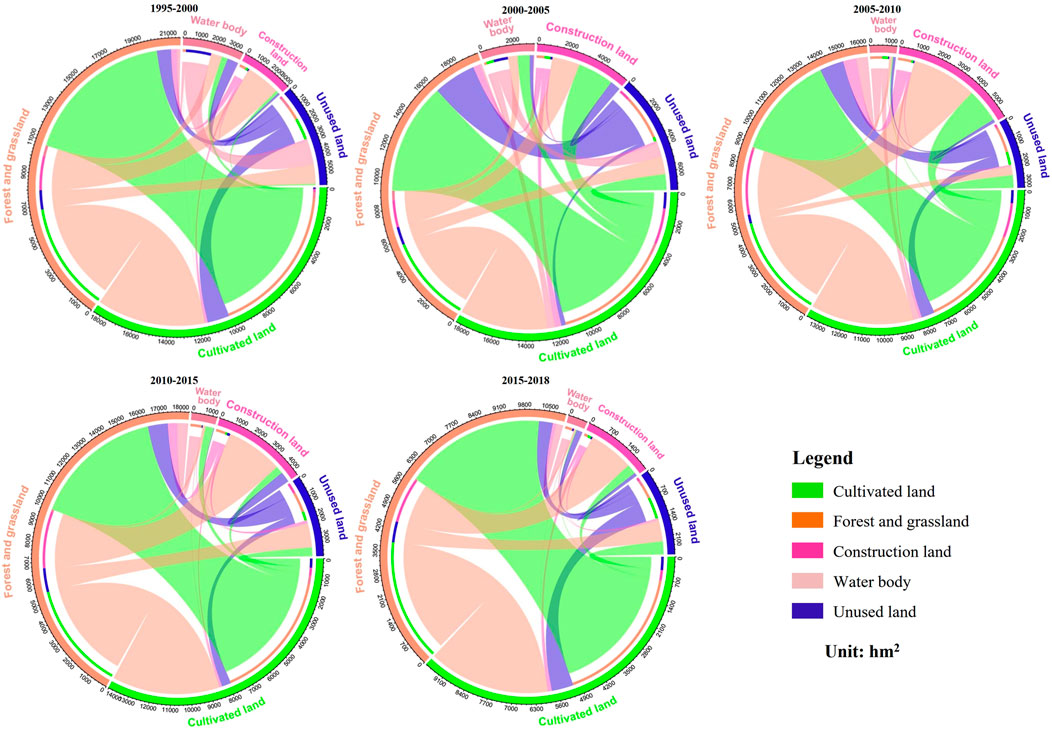
FIGURE 4. Land use types transfer in the mountainous area of Yuxi City from 1995 to 2018.
In general, the land type change in mountainous areas was mainly the mutual transfer between the cultivated land and the forest-grassland. During 1995–2000, it was mainly the transformation from the forest-grassland into the cultivated land, but after 2000, it was mainly the transformation from the cultivated land and unused land into the forest-grassland. The transfer intensity of construction land after 2010 was greater than that before 2010, and the transfer intensity of other land types before 2005 was greater than that after 2005.
From 1995 to 2018, the land type transfer in the basin area changed drastically, mainly among the cultivated land, the forest and grassland, and the construction land (Figure 5). During the study period, the accumulated transfer-out and transfer-in amount of forest and grassland were the largest, and the transfer-out direction was mainly cultivated land and construction land. Among them, the conversion of forest and grassland to cultivated land reached an area of 26,809 hm2, accounting for 83.56% of the cumulative amount of transferred in construction land. The conversion of forest and grassland to construction land reached 11,354 hm2, accounting for 63.45% of the accumulative amount of construction land transferred in. The cultivated land was transferred to forest and grassland and construction land. Among them, the conversion of cultivated land to forest and grassland reached 32,792 hm2, accounting for 76.64% of the cumulative transfer of forest and grassland. The cultivated land was converted to construction land with an area of 4,903 hm2, accounting for 27.41% of the total amount of construction land which was transferred in. The transfer direction of unused land was the cultivated land and forest and grassland, and the total amount of the unused land to cultivated land and the forest and grassland was 9,739 hm2, accounting for 95.04% of the total amount of the unused land transferred out.
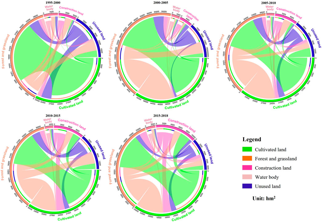
FIGURE 5. Land use types transfer in the basin area of Yuxi City from 1995 to 2018.
In general, the main changes of land types in the basin area occurred in the mutual transfer of the cultivated land, forest-grassland and the construction land, mainly manifested as the transformation from the forest-grassland to the cultivated land and construction land, and the transformation from the cultivated land to the forest-grassland and the construction land. The average annual transfer volume of the first two stages was 5,356 hm2, and the average annual transfer volume of the last three stages was 4,181 hm2. The transfer intensity showed a downward trend.
4 Causative differentiation of land use change between mountainous areas and basin areas
4.1 Analysis framework and factor selection
As internal factors, the natural factors determine the basic pattern of the large-scale land use, with a cumulative effect in time. In the short term, social and economic factors are the main external driving force for land use change (Wu et al., 2022). As the secondary core of the urban agglomeration in central Yunnan, Yuxi City has obvious advantages in location. In mountainous areas and basin areas, there are differences in social and economic development, as well as in land use pattern and its changes due to the different ecological environment differences laid by topography and landform (Figure 6).
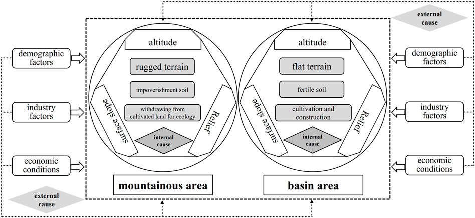
FIGURE 6. Motivation analysis of land use change in moutain-basin of Yuxi City.
According to the actual situation of Yuxi City and the availability of data, the social and economic factors were selected from three aspects: population factors, industrial factors and the economic situation. The influencing factors reflecting the population factors in the study area include the total population (X1), the urbanization rate (X2) and the rural population (X3). The influencing factors characterizing regional industrial factors include the added value of primary industry (X4), the added value of secondary industry (X5), the added value of tertiary industry (X6), the total agricultural output value (X7) and the total industrial output value (X8). The influencing factors reflecting regional economic conditions include the gross regional product (X9), the fixed asset investment (X10), the local fiscal revenue (X11) and the total retail sales of consumer goods (X12).
4.2 Analysis on influencing factors
Due to the difficulty in obtaining partial data of natural factors and their temporal and spatial fixity, Pearson correlation analysis was only used in this study to explore the relationships between socio-economic factors and land use changes. In order to eliminate the possible influences caused by the difference of the data dimension of different indicators, the data was first normalized. Pearson correlation analysis was then conducted on the normalized land area and land use degree of the mountainous area and basin area, and the selected influencing factors, and SPSS 25.0 software was employed to obtain the correlation between the socio-economic factors and the change of land area (Figures 7, 8). (Note: ** indicates that the correlation is significant at the 0.01 level and * indicates that the correlation is significant at the 0.05 level). No matter in the basin area or mountainous area, the correlation between land use change and the socio-economic factors is relatively significant, but there are still obvious regional differences for each type.
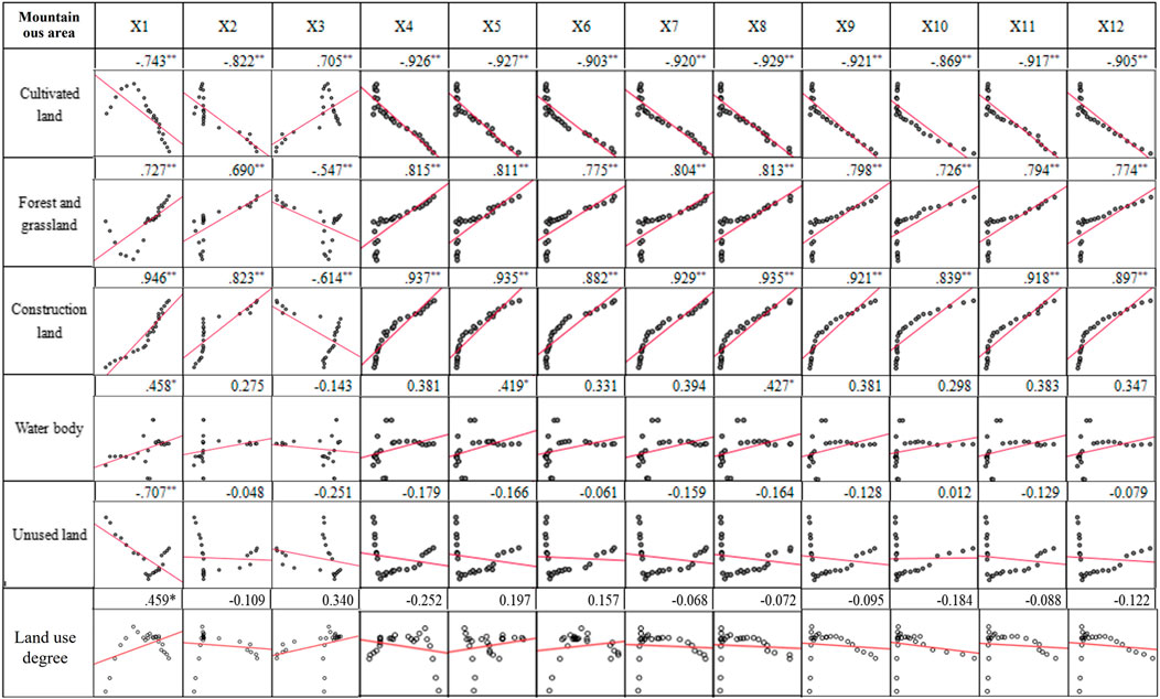
FIGURE 7. Correlation between land use types, land use degree and influencing factors in the mountainous area.
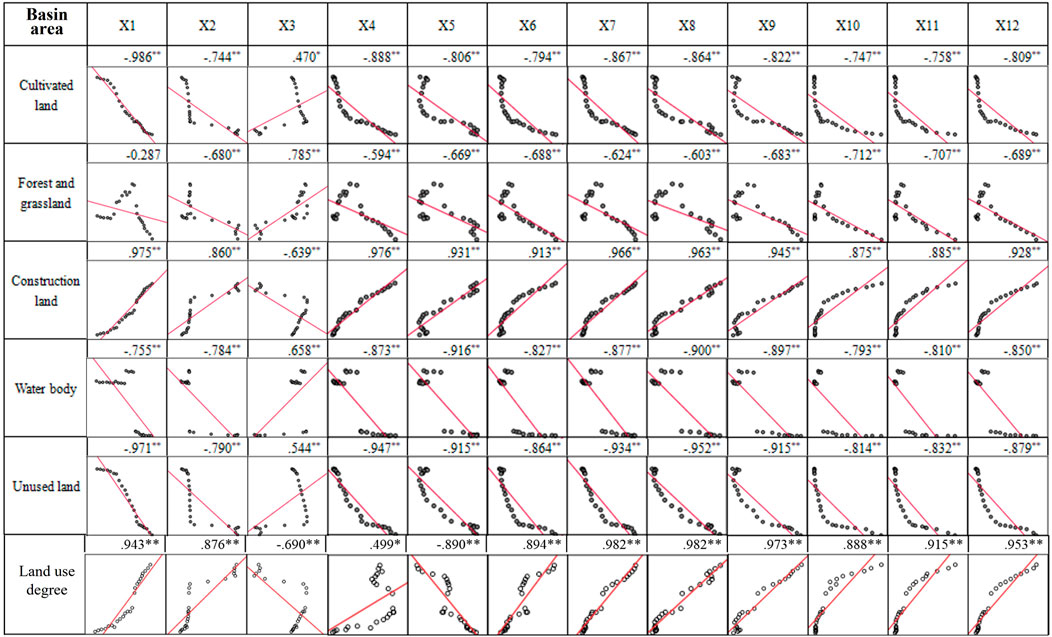
FIGURE 8. Correlation between land use types, land use degree and influencing factors in the basin area.
Among the various types of mountainous areas, cultivated land is most significantly affected by industrial factors, and each factor has a significant negative correlation with the area of cultivated land, and the highest correlation coefficient was found for total industrial output value, followed by economic status. The forest and grassland area is more significantly affected by industrial factors, and each factor has a significant positive correlation with it. Besides, the correlation coefficient of the added value of the primary industry is the highest. The area of construction land has a significant positive correlation with industrial factors and economic conditions, also has the largest correlation coefficient with the total population. Except for the total population, there is no significant correlation between the area of water body and unused land and socioeconomic factors. The mountain water area is positively correlated with the total population, and the unused land area is negatively correlated with the total population, and the correlation degrees are all low. In addition to being significantly positively correlated with the total population, the degree of land use has no significant correlations with other factors (Figure 7). Therefore, the total population of the mountainous areas has the most significant impact on the area of the built-up land. Secondly, the cultivated land, forest and grassland and built-up land in mountainous areas are significantly affected by the added value of primary and secondary industries and the total industrial output value.
Except for the rural population, the cultivated land in the basin area is significantly negatively correlated with other socio-economic factors, among which the correlation coefficient between the total population and the cultivated land area is the largest, and the cultivated land is more affected by industrial factors than other factors. The correlation direction between the forest and grassland and the social and economic factors is similar to that of cultivated land, but the correlation degree is significantly lower, and the correlation coefficient between the completed investment of fixed assets and the area of forest and grassland is the highest. Except for the rural population, the construction land has a significant positive correlation with other factors, and the industrial factor has the most significant influence, and the total population and the added value of the primary industry have the highest correlation degree. Except for the rural population, the area of water body and the area of unused land are significantly negatively correlated with other socioeconomic factors. The correlation coefficient between the area of water body and the added value of the secondary industry is the highest, while the correlation coefficient between the unused land area and the total population is also the highest. The land use degree is significantly correlated with all factors, except for the rural population and the added value of the secondary industry, which are significantly negatively correlated, and the rest are significantly positively correlated (Figure 8). Therefore, the cultivated land and unused land in the basin area are most significantly affected by the total population. The construction land is most significantly affected by the total population and the added value of the primary industry. What follows by the construction land is more obviously affected by the total agricultural output value and industrial output value, and the land use degree is obviously affected by the socio-economic effect.
5 Discussion
With the increasing impact of human activities and climate change on the Earth’s surface system, the natural and human elements as well as the natural-socio-economic complex system are also undergoing dramatic changes. It reflects the complex spatial pattern and process mechanism of physical geography and human geography, and the understanding of this pattern, process and mechanism is inseparable from the analysis technology of information geography. In this study, mountainous areas and basin areas are regarded as two different spatial types of human-land system, and the research results show that the dynamic change process of land use is significantly different. This study believes that this is not only the result of the formation of different geographical patterns, but also the driving factors for further development of geographical pattern differences. At the same time, the different land use structure and change characteristics of the mountainous area and the basin area are closely related to the local natural environment, social and economic factors (Wu and Xie, 2019). One of the biggest inspirations of this research process is that geography, on the basis of being divided into three branches: physical geography, human geography and information geography, has once again moved towards synthesis in the field of human-earth system research (Fan, 2018). Thus, to some extent, it effectively responds to and corroborates the thinking of Chen Fahu, chairman of the Geographical Society of China, on the establishment of a new research branch of “Comprehensive Geography,” based on the system of geographical science. He believes that “regional synthesis is the basis for the existence of geographic science, the greatest feature of geographic science, and also the biggest difficulty of geographic science”. Therefore, comprehensive geography should be “guided by the methods and theories of geographic science, to solve all kinds of practical application problems closely related to the development of nature and human society and economy”. That is to say, “the regionality of geography is based on the human-land relationship, using the new means of information geography to integrate the process of physical geography and human geography to understand the regional spatial process, forming a second-level discipline of comprehensive geography” (Chen et al., 2021).
Previous studies have found that the land use pattern in mountainous areas of southwest China is affected by the landform of mountains and river valleys, which is mainly dominated by forest and grassland (Zhang et al., 2021), followed by cultivated land. Forest and grass land and a large number of sloping farmland are mainly distributed in mountainous areas, and high-quality farmland is mainly continuously distributed in flat basin area, trough valley area and low mountain valley area (Li et al., 2020; Liang et al., 2021; Ma et al., 2021; Zhang et al., 2021). Before 2000, mountain forests were largely cut down (Li et al., 2019), and the area of arable land increased, and it was mainly transferred from woodland and grassland (Yang et al., 2017). Since 2000, with the acceleration of urbanization and industrialization in the mountainous areas of Southwest China, the land use types have changed greatly. A large number of high-quality cultivated land has been occupied in the basin area, and the construction land has increased significantly (Ma et al., 2021). The conversion of the land use types mainly occurred between cultivated land, woodland and grassland (Li et al., 2019). With the implementation of the national policy of “returning farmland to forest” and the government’s emphasis on ecological environment protection, the cultivated land in mountainous areas was transferred to woodland and grassland (Yang et al., 2017), and the expansion intensity of urban construction land in basin areas was significantly higher than that in mountainous areas (Wang et al., 2021). Yuxi City is located in Yunnan Province, a mountainous area in the southwest of China. It is a typical area with alternating mountains and basins. The natural ecological conditions are fragile, the land use conversion is dynamic, and at the same time, it is disturbed by high-intensity human activities and affected by governance policies. In addition to the three major characteristics of regionality, space and complexity under the traditional geographical concept, there are also two emerging characteristics of conflict and dynamicity. In the real world, Yuxi City and other mountainous areas are similar to a certain extent, that is, there are more mountains and fewer basins. The conflicts between the economic and the social development and ecological environmental protection are inevitably transformed into a conflict between the land use of regional human activities and the land use of biodiversity protection, which is manifested as the conflict between land resources and their natural ecological function and human development function. Before 2000, due to the growth of population and the livelihood characteristics of relying on farming output, farmers in mountainous areas reclaimed a large number of cultivated land, and the overdevelopment of land brought serious soil erosion and other problems (Zhang et al., 2018). After 2000, it entered the stage of rapid urbanization. Although the high-quality cultivated land in the basin area was largely occupied due to urban construction and industrial development, the rapid economic development also created a large number of employment opportunities, which provided conditions for the large-scale migration of farmers in mountainous areas to the basin area. The transfer of rural labor force in mountainous areas mitigated the human disturbance of mountainous land (Tian et al., 2010), resulting in farmland abandonment and marginalization (Shao et al., 2015), idle and abandoned homesteads (Liu et al., 2009), forest expansion and restoration of grassland natural vegetation (Li and Zhao, 2011).
With the accelerated development of urbanization in the basin area, population migration has a significant impact on the land use in the area of population outflow and inflow. The migration of population from mountainous areas to basin areas leads to the difference and correlation between the two geographical spaces in the spatio-temporal dynamic changes of land use (Zhang and Li, 2021). With the enhancement of productivity and economic radiation capacity, the intensity of construction land expansion increases accordingly, thus promoting the intensive use of land. However, the situation of the cultivated land protection is severe, and part of natural ecological space is occupied. In mountainous areas, because of labor output, reduction in human activity intensity, and changes in livelihood patterns, farmers gradually abandoned their arable land, and cultivated land gradually evolved into forest and grassland, showing the phenomenon of shrinking cultivated land and expansion of forest and grassland areas. The natural restoration of vegetation reduces the vulnerability of land ecosystem and significantly improves the function of ecological security barrier (Wu et al., 2020b). Due to the differences of the natural environment itself, many factors driving land use/land cover change in the basin area not only act in the internal system of the basin area, but also have an impact on land use/land cover change in the mountainous area. Conversely, the driving factors of land use/land cover change in the mountainous area are also the same. Thus, between the two different geographical spaces of the mountainous area and the basin area, there is not only the interaction within the system, that is, the internal coupling, but also the interaction with the adjacent exterior, that is, the peripheral coupling. According to the dynamic mechanism of different coupling evolution of mountain-basin land use, H. Zhang divided the coupling evolution modes of mountain-basin land use landscape into three categories: strong synergy, moderate synergy and weak synergy (Zhang and Li, 2021), and pointed out that there were different evolution characteristics of land use in southwest mountain and basin land at different stages. From this perspective, land use change should be regarded as a dynamic interaction across spatial and temporal scales within the socio-ecological coupling system (Liu et al., 2013), and the optimal allocation of mountain-basin land use provides a practical grip for the “landing” of mountain-basin land use coupling relationship regulation.
In addition, according to the availability of data, this study selected three factors of population, industry and economy to analyze the factors which would influence land use change. The land use data mainly came from the survey data of land use change in the past years, and the social and economic data mainly came from the statistical yearbook and the statistical bulletin of national economic and social development in the past years. Some data showed a sudden change due to the inconsistency of the statistical caliber before and after, which may have a certain impact on the magnitude of the Pearson correlation coefficient, but did not affect its significance and correlation direction. At the same time, the mountain-basin system is complex and comprehensive. In addition to the factors selected in this paper, the influencing factors of land use change should also consider the differential effects of the special regional policies, such as nearby urbanization, relocation of impoverished residents, rural revitalization, plateau characteristic agriculture development, and ecological protection on the coupled evolution of mountain-basin land use.
6 Conclusion
Based on the types of mountains and basins in Yuxi City, the spatial and temporal changes of land use and its influencing factors in mountainous areas and basin areas from 1995 to 2018 were analyzed at the township scale by integrating the methods of land use degree, land use change rate, comprehensive dynamic degree of land use, land use consumption degree and land use transfer matrix.
As is shown in the study, the land use change in the mountain-basin system shows a phased character, but the intensity is slowing. The comprehensive dynamic attitude of land use in the mountainous area is significantly higher than that in the basin area from 1995 to 2005, and significantly lower than that in the basin area from 2005 to 2018. The trend of land use reduction in the mountainous area is consistent with that in the basin area, but it was always higher in the mountainous area than in the basin area. There is a significant difference in land type change between mountainous areas and basin areas. The construction land in the basin area increases rapidly, while the cultivated land, forest and grassland and unused land continue to decrease, while the construction land in the mountainous area increases slowly, with the cultivated land increasing first and then decreasing, and the forest and grassland and unused land decreasing first and then increasing. Social and economic development are the main driving factors of land use difference between mountainous areas and basin areas. The radiative agglomeration of the basin area attracts the population to migrate from the mountainous area to the basin area, and promotes the ecological restoration of the vegetation in the mountainous area. The increase of construction land and economic development in the basin area increases non-agricultural employment opportunities, promotes population migration, and reduces the cultivated land in the mountainous area, increases the forest and grass land, and continues to improve the ecology.
There are obvious differences in the characteristics of land use change in the mountainous area and the basin area at different time periods. When the urbanization level is low, the land use change in the mountainous area is more drastic than that in the basin area. However, with the rapid improvement of the urbanization level, the population in the mountainous area migrates to the basin area, and the intensity of land use change in the basin area is significantly higher than that in the mountainous area. The non-agricultural construction land in the basin area is rapidly increasing, the protection of cultivated land is severe, and part of the natural ecological space is occupied. In the mountainous area, arable land is abandoned, and the phenomenon of empty villages is serious. The natural restoration of vegetation reduces the vulnerability of land ecosystem, and the function of ecological security barrier is significantly improved. Influenced by the difference of social and economic development, a mutual “driving” and “linkage” relationship between the mountainous area and the basin area exist, which brings the difference of coupling evolution of the land use, so that the urban expansion and the increase of construction land in the basin area are mutually causal with the decline of the mountainous area, the decrease of cultivated land and the increase of forest and grassland.
Data availability statement
Publicly available datasets were analyzed in this study. This data can be found here: www.gscloud.cn. The datasets presented in this study are from the interpretation data of remote sensing images and statistical yearbooks of counties and districts.
Author contributions
LW and BX contributed to the conception of this study. JZ and SY carried out the design and production of some diagrams. LW, BX, and JL contributed significantly to the analysis and manuscript preparation. LW performed the data analyses and wrote the manuscript. BX and JL helped perform the analysis with constructive discussions. All authors contributed to the article and approved the submitted version.
Funding
This study was supported by the National Natural Science Foundation of China (Grant no. 42161041).
Conflict of interest
The authors declare that the research was conducted in the absence of any commercial or financial relationships that could be construed as a potential conflict of interest.
Publisher’s note
All claims expressed in this article are solely those of the authors and do not necessarily represent those of their affiliated organizations, or those of the publisher, the editors and the reviewers. Any product that may be evaluated in this article, or claim that may be made by its manufacturer, is not guaranteed or endorsed by the publisher.
References
Buchner, J., Yin, H., Frantz, D., Kuemmerle, T., Askerov, E., Bakuradze, T., et al. (2020). Land-cover change in the Caucasus Mountains since 1987 based on the topographic correction of multi-temporal Landsat composites. Remote Sens. Environ. 248 (2020), 111967. doi:10.1016/j.rse.2020.111967
Chen, F. H., Li, X., Wu, S. H., Fan, J., Xiong, J. H., and Zhang, G. Y. (2021). Disciplinary structure of geographic science in China. Acta Geogr. Sin. 76 (9), 2069–2073. doi:10.11821/dlxb202109001
Cui, X. L., Bai, H. Y., Wang, T., Guo, L., and Zhang, J. L. (2013). Land use change and driving factors for Jingbian County in farming-pasturing ecotone of North China. Bull. Soil Water Conservation 33 (1), 34–43. doi:10.13961/j.cnki.stbctb.2013.01.040
Fan, J. (2018). Territorial system of human-environment interaction": A theoretical cornerstone for comprehensive research on formation and evolution of the geographical pattern. Acta Geogr. Sin. 73 (4), 597–607. doi:10.11821/dlxb201804001
Fang, Y. Y., Zhao, Y. L., Xue, C. L., and Wei, X. F. (2021). Differentiation characteristics and optimization of mountain basin lands suitable for contrstructions: A case study of guiyang city. J. Nat. Sci. Hunan Normal Univ. 44 (1), 21–29. doi:10.7612/j.issn.2096-5281.2021.01.003
Feng, X. M., Wang, Y. F., Chen, L. D., Fu, B. J., and Bai, G. S. (2010). Modeling soil erosion and its response to land-use change in hilly catchments of the Chinese Loess Plateau. Geomorphology 118 (3-4), 239–248. doi:10.1016/j.geomorph.2010.01.004
Gondwe, M. F., Cho, M. A., Chirwa, P. W., and Geldenhuys, C. J. (2019). Land use/land cover change and the comparative impact of co-management and government-management on the forest cover in Malawi (1999-2018). J. Land Use Sci. 14 (4-6), 281–305. doi:10.1080/1747423x.2019.1706654
Guo, L. Y., Wang, D. L., Qiu, J. J., Wang, L. G., and Liu, Y. (2009). Spatio-temporal patterns of land use change along the Bohai Rim in China during 1985-2005. J. Geogr. Sci. 19 (5), 568–576. doi:10.1007/s11442-009-0568-0
Hou, Y. F., Chen, Y. N., Ding, J. L., Li, Z., Li, Y. P., and Sun, F. (2022). Ecological impacts of land use change in the arid tarim river basin of China. Remote Sens. 14 (8), 1894–1909. doi:10.3390/rs14081894
Isufi, F., and Berila, A. (2021). Using geospatial technology to analyse land use/cover changes in Prishtina, Kosovo (2000-2020). GeoJournal 2021 (2021), 1–15. doi:10.1007/s10708-021-10452-z
Kohler, T., and von Dach, S. W. (2015). CDE links regional research and global efforts for sustainable mountain development. Mt. Res. Dev. 35 (2), 203–207. doi:10.1659/mrd-journal-d-15-00028.1
Kumar, P., Dobriyal, M., Kale, A., and Pandey, A. K. (2021). Temporal dynamics change of land use/land cover in Jhansi district of Uttar Pradesh over past 20 years using LANDSAT TM, ETM+ and OLI sensors. Remote Sens. Appl. Soc. Environ. 23 (2021), 100579. doi:10.1016/j.rsase.2021.100579
Li, J., Liao, H. P., Jin, C., Li, T., and Zhang, T. (2018). Distribution characteristic on terrain gradient of land use pattern and change in the fringe of mountainous cities: A case study of banan district in chongqing. Resour. Environ. Yangtze Basin 27 (2), 296–305. doi:10.11870/cjlyzyyhj201802008
Li, X. B., and Zhao, Y. L. (2011). Forest transition, agricultural land marginalization and ecological restoration. China Popul. Resour. amd Environ. 21 (10), 91–95. doi:10.3969/j.issn.1002-2104.2011.10.014
Li, X. N., Deng, Z. J., Wang, Q. H., Wang, Y. H., and Wan, S. R. (2019). Temporal and spatial dynamics of the land-use types in the Northwest Yunnan from 1986 to 2015. J. Southwest For. Univ. 39 (6), 137–145. doi:10.11929/j.swfu.201903116
Li, Y. J., Yang, X. H., Cai, H. Y., Xiao, L. L., Xu, X. L., and Liu, L. (2014). Topographical characteristics of agricultural potential productivity during cropland transformation in China. Sustainability 7 (1), 96–110. doi:10.3390/su7010096
Li, Y. M., Wang, D. C., Yuan, J., and Liu, X. Z. (2020). Temporal and spatial pattern and functional zoning of land use in Alpine Canyon Region based on terrain gradient. Bull. Soil Water Conservation 40 (6), 303–311.
Liang, J. T., Deng, Y., Cao, J. H., Jin, Z. J., and Li, X. Y. (2021). Temporal and spatial differentiation of the ecosystem service value in typical fault-depression basins. Carsologica Sin. 40 (3), 476–486. doi:10.11932/karst2021y28
Liu, J. G., Hull, V., Batistella, M., DeFries, R., Dietz, T., Fu, F., et al. (2013). Framing sustainability in a telecoupled world. Ecol. Soc. 18 (2), art26. doi:10.5751/es-05873-180226
Liu, Y. S., Liu, Y., and Zhai, R. X. (2009). Geographical research and optimizing practice of rural hollowing in China. Acta Geogr. Sin. 64 (10), 1193–1202.
Liu, Y. X., and Li, Y. B. (2020). Spatial evolution of land use production function in the basin of Guizhou Province under the background of rural transformation. Geogr. Res. 39 (2), 430–446. doi:10.11821/dlyj020180650
Lu, C. Y., Qi, L. G., and Sang, C. J. (2007). Analysis on mathematic model of land-use changes. Resour. Dev. Mark. 23 (1), 25–27.
Lu, H. Y., Wei, Y. Q., Yang, S. C., and Liu, Y. W. (2019). Regional spatial patterns and influencing factors of environmental auditing for sustainable development: Summaries and illuminations from international experiences. Environ. Dev. Sustain. 22 (2019), 3577–3597. doi:10.1007/s10668-019-00357-w
Ma, H. Y., Zhang, L. L., Wei, X. Q., Shi, T. T., and Chen, T. X. (2021). Spatial and temporal variations of land use and vegetation cover in Southwest China from 2000 to 2015. Chin. J. Appl. Ecol. 32 (2), 618–628. doi:10.13287/j.1001-9332.202102.017
Ma, Z. B., Chen, X. P., and Chen, H. (2018). Multi-scale spatial patterns and influencing factors of rural poverty: A case study in the liupan mountain region, gansu province, China. Chin. Geogr. Sci. 28 (2), 296–312. doi:10.1007/s11769-018-0943-9
Matlhodi, B., Kenabatho, P. K., Parida, B. P., and Maphanyane, J. G. (2021). Analysis of the future land use land cover changes in the gaborone dam catchment using CA-markov model: Implications on water resources. Remote Sens. 13 (13), 2427–2446. doi:10.3390/rs13132427
Meer, M. S., and Mishra, A. K. (2020). Land use/land cover changes over a district in Northern India using remote sensing and GIS and their impact on society and environment. J. Geol. Soc. India 95 (2), 179–182. doi:10.1007/s12594-020-1407-2
Meybeck, M., Green, P., and Vörösmarty, C. (2001). A new typology for mountains and other relief classes. Mt. Res. Dev. 21 (1), 34–45. doi:10.1659/0276-4741(2001)021[0034:Antfma]2.0.Co;2
Msofe, N. K., Sheng, L. X., Li, Z. X., and James, L. (2020). Impact of land use/cover change on ecosystem service values in the Kilombero Valley Floodplain, Southeastern Tanzania. Forests 11 (1), 109. doi:10.3390/f11010109
Nguyen, T. C., Whelan, M., and Nichols, J. D. (2022). Soil erosion response to land use change in a mountainous rural area of Son La Province of Vietnam. Environ. Monit. Assess. 194 (3), 149. doi:10.1007/s10661-022-09844-6
Olorunfemi, I. E., Fasinmirin, J. T., Olufayo, A. A., and Komolafe, A. A. (2020). GIS and remote sensing-based analysis of the impacts of land use/land cover change (LULCC) on the environmental sustainability of Ekiti State, southwestern Nigeria. Environ. Dev. Sustain. 22 (2), 661–692. doi:10.1007/s10668-018-0214-z
Parven, A., Pal, I., Witayangkurn, A., Pramanik, M., Nagai, M., Miyazaki, H., et al. (2022). Impacts of disaster and land-use change on food security and adaptation: Evidence from the delta community in Bangladesh. Int. J. Disaster Risk Reduct. 78 (2022), 103119. doi:10.1016/j.ijdrr.2022.103119
Richards, J. A. (1995). Remote sensing digital image analysis. an introduction. Geol. Mag. 132 (4), 453–457.
Scheurer, T., and Jost, S. (2012). Sustainable mountain development beyond Rio+20: Regional and national perspectives. Mt. Res. Dev. 32 (1), 92–95. doi:10.1659/mrd-journal-d-12-00004.1
Schild, A. (2008). ICIMOD's position on climate change and mountain systems. Mt. Res. Dev. 28 (3-4), 328–331. doi:10.1659/mrd.mp009
Schild, A., and Sharma, E. (2011). Sustainable mountain development revisited. Mt. Res. Dev. 31 (3), 237–241. doi:10.1659/mrd-journal-d-11-00069.1
Shao, J. A., Zhang, S. C., and Li, X. B. (2015). Farmland marginalization in the mountainous areas: Characteristics, influencing factors and policy implications. J. Geogr. Sci. 25 (6), 701–722. doi:10.1007/s11442-015-1197-4
Siddik, M. S., Tulip, S. S., Rahman, A., Islam, M. N., Haghighi, A. T., and Mustafa, S. M. T. (2022). The impact of land use and land cover change on groundwater recharge in Northwestern Bangladesh. J. Environ. Manag. 315 (2022), 115130. doi:10.1016/j.jenvman.2022.115130
Smiraglia, D., Ceccarelli, T., Bajocco, S., Perini, L., and Salvati, L. (2015). Unraveling landscape complexity: Land use/land cover changes and landscape pattern dynamics (1954-2008) in contrasting peri-urban and agro-forest regions of northern Italy. Environ. Manag. 56 (4), 916–932. doi:10.1007/s00267-015-0533-x
Solomon, H., Bewket, W., Nyssen, J., and James, L. (2020). Analysing past land use land cover change and CA-Markov-based future modelling in the Middle Suluh Valley, Northern Ethiopia. Geocarto Int. 35 (3), 225–255. doi:10.1080/10106049.2018.1516241
Song, Z., Han, J. X., Ni, H. Y., Wang, D. H., and Huang, T. J. (2021). Research on development and protection planning of land space for Chengdu-German-Mei-Zizhi urban construction in Sichuan Province Geology in China. 2021, 1–18.
Tian, Y. J., Li, X. B., Ma, G. X., and Hao, H. G. (2010). Influences of labor emigration from agriculture on the production abandonment of cultivated land in ecological sensitive areas. China Land Sci. 24 (7), 4–9. doi:10.13708/j.cnki.cn11-2640.2010.07.004
Twongyirwe, R., Fisher, E., Karungi, C., and Ndugu, N. (2022). Projected land use change in an oil-rich landscape in Uganda: A participatory modelling approach. Extr. Industries Soc. 10 (2022), 101071. doi:10.1016/j.exis.2022.101071
Wang, X. X., Peng, L., Liu, S. J., and Wei, Y. Y. (2021). Characteristics and the driving mechanism of urban construction land expansion in mountainous areas of southwest China. Chin. J. Ecol. 40 (9), 2895–2903. doi:10.13292/j.1000-4890.202109.017
Wolde, Z., Wu, W., Likessa, D., Omari, R., and Ketema, H. (2021). Understanding the impact of land use and land cover change on water–energy–food nexus in the Gidabo Watershed, East African Rift Valley. Nat. Resour. Res. 30 (3), 2687–2702. doi:10.1007/s11053-021-09819-3
Wu, F. Q., Mo, C. J., and Dai, X. J. (2022). Analysis of the driving force of land use change based on geographic detection and simulation of future land use scenarios. Sustainability 14 (9), 5254–5270. doi:10.3390/su14095254
Wu, L. N., Yang, S. T., Liu, X. Y., Luo, Y., Zhou, X., and Zhao, H. G. (2014). Response analysis of land use change to the degree of human activities in Beiluo River basin since 1976. Acta Geogr. Sin. 69 (1), 54–63. doi:10.11821/dlxb201401005
Wu, L., and Xie, B. G. (2019). The variation differences of cultivated land ecological security between flatland and mountainous areas based on LUCC. PLoS One 14 (8), e0220747. doi:10.1371/journal.pone.0220747
Wu, L., Xie, B. G., Xiao, X., Xue, B., and Li, J. Z. (2020a). Classification method and determination of mountainous area types at township scales: A case study of Yuxi city, yunnan province. Complexity 2020, 1–13. doi:10.1155/2020/3484568
Wu, L., Zhou, J., and Li, Z. H. (2020b). Applying of GA-BP neural network in the land ecological security evaluation. Int. J. Comput. Sci. 47 (1), 1–8.
Xie, F. D., Wu, X., Liu, L. S., Zhang, Y. L., and Paudel, B. (2021). Land use and land cover change within the Koshi River Basin of the central Himalayas since 1990. J. Mt. Sci. 18 (1), 159–177. doi:10.1007/s11629-019-5944-3
Yang, M., Zhang, G. L., and Hou, Y. P. (2011). Advances and prospects of the driving force of regional land use change researches. Geogr. Geo-Information Sci. 27 (1), 95–100.
Yang, Y. L., Ma, M. G., and Zhou, Z. Y. (2017). Research on land use patterns and temporal and spatial evolution in mountainous watershed based on topographic gradient. Eng. Surv. Mapp. 26 (12), 8–16. doi:10.19349/j.cnki.issn1006-7949.2017.12.002
Yang, Y. W., Tian, Y. C., Zhang, Q., Tao, J., Huang, Y. J., Gao, C. P., et al. (2022). Impact of current and future land use change on biodiversity in nanliu river basin, beibu gulf of south China. Ecol. Indic. 141 (2022), 109093. doi:10.1016/j.ecolind.2022.109093
Zhang, B. L., Cai, W. M., Zhang, F. R., Feng, T., and Zhang, L. (2016). Spatio-temporal evolution of rural settlements and its driving forces in Yishui County, Shandong Province from Sui dynasty to 1949. Geogr. Res. 35 (6), 1141–1150. doi:10.11821/dlyj201606011
Zhang, B. L., Gao, J. B., Ggo, Y., Cai, W. M., and Zhang, F. R. (2018). Land use transition of mountainous rural areas in China. Acta Geogr. Sin. 73 (3), 503–517. doi:10.11821/dlxb201803009
Zhang, H., and Li, Y. B. (2021). Coupling and coordinated evolution between land-use and landscape in mountain-basin system in the context of rural transformation: A case study of six mountain-basin systems in guizhou province, China. Mt. Res. 39 (2), 248–261. doi:10.16089/j.cnki.1008-2786.000592
Zhang, Y. X., Halder, P., Zhang, X. N., and Qu, M. (2020). Analyzing the deviation between farmers' land transfer intention and behavior in China's impoverished mountainous area: A logistic-ISM model approach. Land Use Policy 94 (2020), 104534. doi:10.1016/j.landusepol.2020.104534
Zhang, Y. Y., Sun, M. Y., Yang, R. J., and Zhang, L. (2021). Impact of land-use change on ecosystem service value in Southwest China. J. Environ. Eng. Technol. 12 (1), 207–214. doi:10.12153/j.issn.1674-991X.20210159
Zhao, H. F., He, H. M., Bai, C. Y., and Zhang, C. J. (2018). Spatial-temporal characteristics of land use change in the Loess Plateau and its environmental effects. China Land Sci. 32 (7), 49–57. doi:10.11994/zgtdkx.20180622.104942
Zhou, S. G., Shao, Q. Q., and Cao, W. (2016). Characteristics of land use and land cover change in the Loess Plateau over the past 20 years. J. Geo-information Sci. 18 (2), 190–199. doi:10.3724/SP.J.1047.2016.00190
Keywords: land use change, mountainous areas, basin areas, township scale, Yuxi city
Citation: Wu L, Zhou J, Xie B, Yang S and Li J (2022) Spatiotemporal differences of land use pattern between mountainous areas and basin areas at township scale: A case study of Yuxi City. Front. Environ. Sci. 10:1029917. doi: 10.3389/fenvs.2022.1029917
Received: 28 August 2022; Accepted: 16 September 2022;
Published: 05 October 2022.
Edited by:
Bing Xue, Institute for Advanced Sustainability Studies (IASS), GermanyCopyright © 2022 Wu, Zhou, Xie, Yang and Li. This is an open-access article distributed under the terms of the Creative Commons Attribution License (CC BY). The use, distribution or reproduction in other forums is permitted, provided the original author(s) and the copyright owner(s) are credited and that the original publication in this journal is cited, in accordance with accepted academic practice. No use, distribution or reproduction is permitted which does not comply with these terms.
*Correspondence: Binggeng Xie, xbgyb1961@163.com; Jingzhong Li, lijingzhong@xcu.edu.cn