Analysis of runoff variations in an arid catchment based on multi-model ensemble- a case study in the Tarim River Basin in Central Asia
 Xiaoyu Gao1
  Gonghuan Fang
 Yaning Chen
 Xueqi Zhang
- 1University of Chinese Academy of Sciences, Beijing, China
- 2State Key Laboratory of Desert and Oasis Ecology, Key Laboratory of Ecological Safety and Sustainable Development in Arid Lands, Xinjiang Institute of Ecology and Geography, Chinese Academy of Sciences, Urumqi, China
Runoff variation is of significant importance to the current and future water availability of a region, particularly in arid regions, and plays a crucial role in economic and social development. The Tarim River Basin, spanning an area of approximately 102 × 104 km2, is the largest inland river basin in China. Due to the basin’s extremely dry climate, water shortage is the most critical natural factor restricting socio-economic development in the region. This study focuses on analyzing the historical and future runoff changes of the four headstreams (the Kaidu, Aksu, Yarkand, and Hotan rivers) in the Tarim River Basin with historical observations and multiple-model projections. The results indicate that the runoff of the Tarim’s four headstreams showed an increasing trend during 1957–2022, with a remarkable increment of 40.70 × 10⁸ m3, or 18% in percentage. Rising temperatures and precipitation are the main reasons for the runoff’s increase. Higher temperature accelerates the melting of glaciers, leading to enhanced recharge of meltwater, while more precipitation also boosts the increase in river runoff. Based on the modelling results from the extended SWAT (Soil and Water Assessment Tool), the runoff in the Kaidu, Aksu, Yarkand, and Hotan rivers will remain at a high level in the near future (−2035), with an average increase of 3.2%–7.55%. In the mid 21st century (2036–2065), the runoff of the Yarkand and Hotan River originated from the Kunlun and Karakoram mountains is expected to continue increasing by around 6.25%–15.2%. Under SSP126, the tipping point of glacier melt runoff in the basin may happen by 2058, while under SSP370 and SSP585 scenarios, it may be around 2080. The timing of peak water aligns with projections in the mountainous Asia, but is later compared to the tropical Andes, Western Canada, and the Swiss Alps, whose peak water has already been reached. The results of this study can provide a scientific basis for the allocation and efficient utilization of water resources in the Tarim River Basin and offer valuable insights into the forthcoming runoff changes in mountainous regions.
1 Introduction
The Tarim River Basin is a typical river basin located in northwestern China. It covers an area of approximately 102 × 104 km2 and is bordered by the Tianshan Mountains to the north, the Karakorum-Kunlun and Altun Mountains to the south, and the Pamir Plateau to the west. The basin consists of nine river systems (the Kaidu-kongque, Dina, Weigan-Kuqa, Aksu, Kashgar, Yarkand, Hotan, Keriya, and Cherchen rivers), along with numerous small rivers. However, due to the combined influence of climate change and human activities, several headwaters of the Tarim River, including the Dina, Weigan-Kuqa, Kashgar, Keriya, and Cherchen, have dried up and separated from the mainstream (Chen, 2015). At present, only four sources–the Kaidu-Kongque, Aksu, Yarkand and Hotan rivers–have surface hydrological connections with the Tarim River. Together, these rivers form the current hydrological pattern of “four sources and one mainstream” that characterizes the Tarim River Basin (Figure 1).
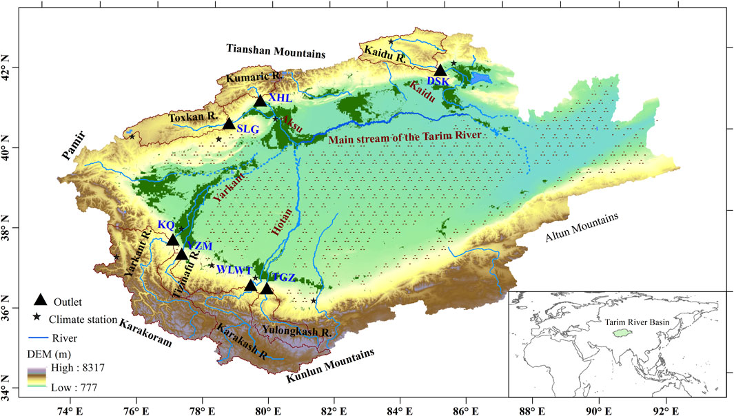
FIGURE 1. Study area of the Tarim River Basin with the spatial location of the headwaters and the corresponding outlets.
The Tarim River Basin has an extremely dry climate with scarce precipitation (Chen et al., 2009). Water shortage is thus the main natural factor restricting the region’s economic and social development and ecological security. The runoff provides the primary water source for the basin’s irrigated agriculture and determines the prosperity or declining of this arid region. The runoff is mainly recharged by glacier and snow melt water in the high mountainous area, rainfall in the middle-altitude forest belt, and bedrock fissure water in the low mountain zone (Chen et al., 2009; Chen et al., 2019; Wang et al., 2023). The multiple recharge sources make the hydrological processes very complex. Given its special location and geographical features, the hydrological processes and climate change of the Tarim River Basin attract the attention of numerous scholars (Xu et al., 2004; Duethmann et al., 2015; Duethmann et al., 2016; Shen et al., 2018; Yang et al., 2019; Wang et al., 2021; Bolch et al., 2022; Fang et al., 2022; Wortmann et al., 2022). Their research results show that the climatological and hydrological processes are highly sensitive to climate change (Chen et al., 2006; Wortmann et al., 2022). The climatological and hydrological processes in the basin have altered significantly (Chen et al., 2009; Chen, 2014). Generally, it’s basically been agreed that the runoff of the mountainous areas generally showed an increasing trend on the whole (Yao et al., 2022; Chen et al., 2023).
However, the future changes of runoff of the region is hotly debated and inadequately quantified. Some authors suggested that the river runoff may show an increasing trend prior to 2050, but it will likely decrease in the long run (the end of the 21st century) (Liu et al., 2013; Ban et al., 2018). More specifically, river discharge is projected to first increase by about 20% in the Aksu River catchments with subsequent decreases of up to 20%. In contrast, discharge in the Hotan and Yarkand catchments is projected to increase by 15%–60% towards the end of the century (Bolch et al., 2022; Su et al., 2022; Wortmann et al., 2022; Xiang et al., 2022). The increase in runoff is mainly caused by the larger increase in precipitation and glacier runoff than the decrease in winter snow accumulation. For the Kaidu River, runoff will reduce with great uncertainty in precipitation (Zhang et al., 2017; Zhao et al., 2021), but the snowmelt runoff will increase significantly (Xiang et al., 2019). These projections are generally based on GCM outputs and catchment-scale hydrological models and most of them focused on one or two headwaters, and few of them validated the model against the glacier melt processes (Bolch et al., 2022; Su et al., 2022; Wang et al., 2022; Fang et al., 2023).
To fill this gap, this study investigates future changes of runoff used multi-model ensemble constructed by a process-based, well-established glacier-hydrology model SWAT-Glacier (Fang et al., 2018; Fang et al., 2023), a global hydrological model H08 (Hanasaki et al., 2008) and glacier evolution model GloGEM (Zhao et al., 2023). The aim is to achieve a comprehensive understanding of the basin’s overall water resources, especially changes in glacier melt runoff.
This paper is structured as follows. Section 2 outlines the data and methodology. Section 3 presents findings on historical runoff changes, the sensitivity of runoff to climatic factors, and future runoff predictions using model ensemble. This is followed by discussions and conclusions in Section 4 and Section 5.
2 Data and methods
2.1 Data
In this study, the meteorological data for the Tarim River Basin was obtained from the China Meteorological Data Sharing Network and China Meteorological Administration. These meteorological stations mainly monitor air temperature, precipitation, relative humidity, dew point temperature, water vapor pressure, wind speed, and solar radiation. The monitoring step is daily and the time span is from 1951 to 2022. These data were subjected to rigorous homogeneity tests and used as input for hydrological simulation. The daily meteorological data together with the daily streamflow data were used for analysis of historical runoff changes and for model construction and validation.
For future climate change, the daily precipitation and maximum/minimum temperature from the high spatial resolution regional climate model dataset of the Coordinated Regional Downscaling Experiment (CORDEX) (Giorgi and Gutowski, 2015), an important subprogram of the World Climate Research Program (WCRP) was used. This dataset is used to force the SWAT-Glacier model to project future changes in runoff.
The outputs from the H08 model, forced by four global circulation models (GCM) within the Inter-Sectoral Impact Model Intercomparison Project (ISIMIP2b, www.isimip.org), were also analyzed. The time span is from 1990 to 2100.
Monthly temperature and precipitation data from the ERA5-Land reanalysis dataset were used to force the GloGEM to simulate runoff changes during 1999–2021 and to predict future changes (2022–2100) using ten bias-corrected GCM of from CMIP6.
2.2 Methods and models
For the analysis of historical runoff changes, the Mann-Kendall mutation test method was employed in this study to identify abrupt changes in annual runoff (Kendall, 1975). Initially, the simulation of hydrological processes and runoff was conducted using the SWAT-glacier model (Fang et al., 2018; Fang et al., 2023). The SWAT-glacier model integrates a glacier dynamic module into the original version of the SWAT model (Soil and Water Assessment Tool). In SWAT-Glacier, the glacier melt is calculated using the degree-day method (Neitsch et al., 2002), which is a widely accepted approach for accounting for the glacier melt processes. The theoretical basis of the degree-day method and the extension of the SWAT model have been extensively discussed in previous studies (Hock, 2003; Fang et al., 2018). The model is built for each catchment, and is calibrated against daily streamflow, glacier area changes and glacier melt water contribution. For more details on model configuration and calibration, please refer to Fang et al. (2023).
The sensitivity of runoff to climatic factors was investigated through numerical experiments, wherein only one input variable was altered while keeping the others constant. Firstly, the simple climate change scenario [for temperature, an additive change (Δ) is used: ΔT = −1, 0, 1, 2, 3, 4, and 5°C, etc. For precipitation, a relative change (δ) is used: δP = −20%, −10%, 0, 10%, 20%, 30%, etc) was constructed to represent a wide range of changes in climatic variables. Then these climate data were used to force the SWAT-Glacier to determine the changes in streamflow in response to changes in climatic variables.
Regarding future runoff changes, the bias-corrected outputs of the RCM (Regional Climate Model) were utilized to drive the SWAT-Glacier model and estimate projected changes in streamflow. Other meteorological factors such as solar radiation, wind speed, and relative humidity remained unchanged, as these factors were found to be insensitive and have relatively minor impacts on streamflow based on the Sobols’ analysis. In addition, the outputs from the H08 model, forced by four GCMs were also analyzed. Lastly, the outputs of the Global Glacier Evolution Model (GloGEM), driven by ten GCM outputs, were analyzed to understand future changes in glacier melt runoff (Figure 2).
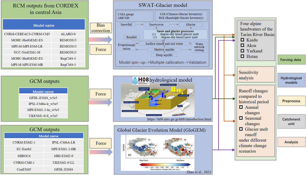
FIGURE 2. Work flow of the multiple model simulation of runoff in the Tarim River Basin. The diagram of H08 is adapted from its and GloGEM are adapted from its official website and the figures of the GloGEM is from Zhao et al. (2023).
3 Results analysis
Based on the meteorological and hydrological observations of the Tarim River and the multi-model ensemble, the historical and future variations of runoff were analyzed, along with the responses of runoff to climatic factors.
3.1 Historical changes in runoff
3.1.1 Inter-annual variations of runoff
During the study period (1957–2022), the runoff from the mountainous headwaters of the Tarim River showed an obvious increasing trend, with the average runoff of the four sources increased from 230.20 × 10⁸ m3 to 270.90 × 10⁸ m3, accounting for a total increase of 40.70 × 10⁸ m3, or 18%. During the same period, the Kaidu, Aksu, Yarkand and Hotan rivers increased by 9.65 × 10⁸ m3, 11.23 × 10⁸ m3, 10.11 × 10⁸ m3, and 9.71 × 10⁸ m3, respectively (Figure 3; Table 1), with the Kaidu and Hotan rivers experiencing the highest relative change, by 27% and 22%, respectively. In addition, the runoff from the Kaidu, Aksu, Yarkand, and Hotan rivers exhibited a “jump increase” in 2010, 1993, 1994, and 1996, respectively. This rise in runoff is closely associated with the considerable temperature rise and precipitation increase. Firstly, the higher temperatures accelerated the melting of snow and glaciers, resulting in a substantial increase in runoff, where is primarily recharged by glacial and snowmelt water. Secondly, the warmer atmosphere has a greater capacity to hold water, potentially leading to an elevation in atmospheric precipitable water, which in turn can influence both extreme and average rainfall patterns. The abrupt fluctuations in temperature and precipitation may be attributed to large-scale circulation processes, particularly the Tibetan Plateau Index B (Chen, 2014). However, in the long term, these abrupt changes could be attributed to natural variations in the climate system (Su et al., 2022).
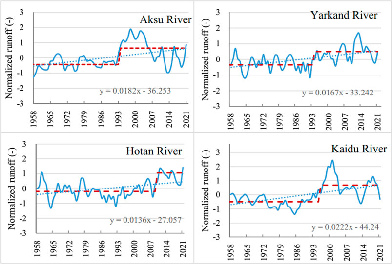
FIGURE 3. Interannual variations of runoffs of the four headwaters in the Tarim River Basin represented by three-year smoothing normalized runoff. Note that the runoff of each source is the sum of runoff from its tributaries and interval flow. The red line indicates the mean runoff during a specific period, while the dotted line represents the linear fitting line.
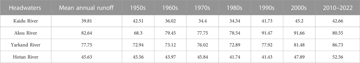
TABLE 1. Variations of runoff in the “four sources” of the Tarim River Basin (unit: 108 m3).
3.1.2 Seasonal changes in runoff
Seasonally, the spring and autumn runoff accounted for about 20%–25%, summer runoff accounted for 40%–65%, and winter runoff accounted for about 10% for the annual runoff in the headwaters of the Tarim River. The Kaidu, Aksu, Yarkand, and Hotan rivers had the smallest proportion of runoff in February (3.20%, 1.29%, 1.85%, and 1.21%, respectively). The maximum runoff of the Aksu, Yarkand, and Hotan rivers for four consecutive months occurred from June to September, accounting for 75.86%, 79.60%, and 82.96% of the entire year, respectively, while that of the Kaidu River occurred from May to August, accounting for only 56.40% of the entire year. The annual distribution of the runoff of the Kaidu River was relatively uniform compared with the other rivers, peaking in July, which accounted for 16.40% of the annual runoff. During the winter, due to scarce precipitation and low temperatures, river runoff was mainly fed by bedrock fissure water and groundwater in the lower mountain zone, and the proportion of runoff was small. This is a common feature in rivers that are mainly fed by glacier and snow meltwater.
During 1957–2022, the Kaidu, Aksu, Yarkand, and Hotan rivers showed an obvious increase in runoff during October to March, with an earlier spring flood. Among these rivers, the runoff increased most significantly in December for the Hotan and Aksu rivers, while the runoff increases most significantly in January for the Yarkand River and in April for the Kaidu River. It is worth noting that although the relative increase was large, the absolute increment of the runoff was small. During April to September, the runoff also showed an increasing trend. Although the relative increase was less than that during October to March, the actual increment was larger, resulting in a greater and more concentrated flooding trend.
3.2 Sensitivity of runoff to climate factors
There is a close relationship between runoff change and climate change in the Tarim River Basin. Throughout the first half of the historical study period (1957–1997), there was a steady rise in both temperature and precipitation. Then, in the late 1990s, the temperature “leaped” (Chen, 2014; Chen et al., 2023), with the mean temperature increasing by 0.93°C after 1998 compared to the period of 1957–1997. Precipitation also showed an obvious rising trend at an increasing rate of 7.47 mm/10a. In one hand, warmer temperatures accelerated the melting of glaciers, leading to more glacial meltwater. On the other hand, warmer temperature boosted evapotranspiration, and resulting in increased water consumption. The increased precipitation had a positive effect on river runoff. Using the Simple Climate Change scenario, this study analyzed the response of runoff to climatic factors of the headwaters (Kaidu River, Aksu River, Yarkand River, and Hotan River). The results revealed notable differences in hydrological changes among different rivers.
(1) Runoff in the Kaidu River increased quasi-linearly with increases in precipitation, while the response of runoff to temperature depending on the range of the temperature change. When the temperature increased by more than 2°C, the runoff decreased significantly, but when the temperature rose less than 2°C, the changes in runoff were almost linear with the changes in precipitation. The elastic coefficient (δQ/δP) was about 1.0, indicating that when average annual precipitation increased by 1%, the average annual runoff will increase by 1%. The runoff depth is 197 mm, and the mean annual precipitation is 378 mm, which suggests a sub-humid condition of the mountainous Kaidu River Catchment. However, it is important to note that this value is not fixed and can be influenced by changes in future climate conditions (Tang et al., 2019). If precipitation decreases or increases in the future, this value may also fluctuate accordingly.
(2) For the Aksu River, the runoff increased almost linearly with the increase in precipitation when the temperature remained unchanged. Precipitation increased by 10% and runoff increased by about 3%. The response of the runoff to temperature was more complex. When the temperature rose by 1°C, the runoff increased by about 5%. However, when the temperature fell by 1°C, the runoff decreased by 14%. The findings indicate that evapotranspiration and glacier melt runoff are sensitive to temperature.
(3) The increase in temperature and precipitation in the Yarkand River Basin boosted the increase in runoff, as the runoff appeared to be very sensitive to temperature. An increase of 1°C in temperature resulted in an increase in runoff by 10.2%–16.2%. However, when precipitation rose 10%, runoff increased by only about 3%. When the temperature increased within 2°C, the runoff increased 3.3%–7.7%, and when the temperature increased by 3°C, 4°C, and 5°C, the runoff increased by 17.3%, 24.6%, and 11.8%, respectively.
(4) For the Hotan River, the runoff responds differently to climatic factors for its two tributaries (i.e., Karakash and Yulongkash River). The Karakash River is highly sensitive to the snow related processes, while the Yulongkash River is sensitive to glacier melt processes. Additionally, the runoff of the Kalakash River showed an “increase-decrease” trend with rises in temperature, whereas the runoff of the Yulongkash River presented an increasing trend with rising temperature but low sensitivity to precipitation changes.
3.3 Forecast of future runoff
3.3.1 Runoff prediction based on the SWAT model
This study uses the corrected high-resolution climate dataset CORDEX to force the distributed hydrological model SWAT-Glacier. The model performance is shown in Table 2. The estimation period includes the historical period 1976–2005 and the future periods (i.e., 2006–2035, 2036–2065, and 2066–2095). The temperature of the Tarim River Basin will continue rising under the RCP4.5 and RCP8.5 scenarios. Compared with the historical period (1976–2005), the temperature will rise by 1.22°C ± 0.72°C during the middle of the 21st century (2036–2065), with a greater increase occurring in the southern slopes of the Tianshan Mountains compared with the northern slopes of the Kunlun Mountains. The rise in average temperature in the Kaidu and Aksu catchments is anticipated to be 1.39°C, while that in the Yarkand and Hotan river basins is estimated to be 1.21°C. In the Tarim River Basin, the temperature is expected to increase by 4.27°C ± 2.59°C by the end of the 21st century. It is worth pointing out that the various GCM-RCM models also show different predictions.
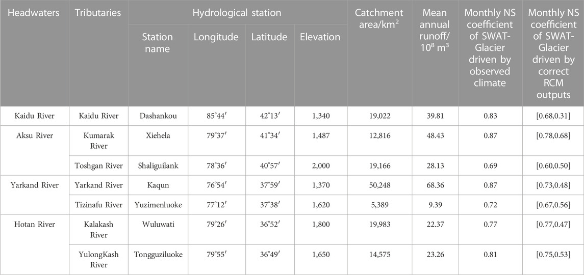
TABLE 2. Model performance of the SWAT-Glacier in the “four source streams” of the Tarim River Basin.
In terms of future precipitation, precipitation shows an overall increasing trend compared with 1976–2005. During 2036–2065, the average increase in precipitation in the Tarim River Basin is anticipated to be 3.81 ± 14.72 mm, with the Yarkand catchment expected to have the largest increase, followed by the Kaidu catchment. By the end of the 21st century, the precipitation is expected to increase by 20.52 ± 27.66 mm.
In the future, the runoff will remain at a high level with moderate fluctuations. In the near future (−2035), the runoff of the Kaidu, Aksu, Yarkand, and Hotan rivers will increase slightly, with an average increase of 3.2%–7.55%. The increase is mainly due to the increase in ice/snow melt water and precipitation in the alpine areas caused by global warming. For the mid 21st century (2036–2065), the average increase in runoff in the Yarkand and Hotan rivers will be around 6.25%–15.2% compared with the historical period, while the runoff in the Kaidu River will remain the current level (Table 3).
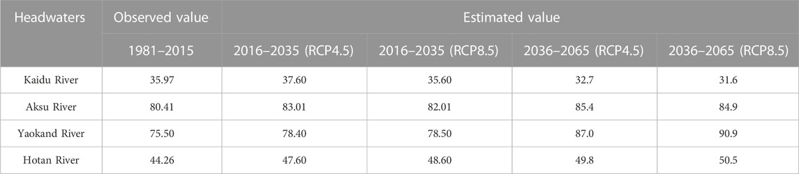
TABLE 3. Prediction list of future runoff changes of typical rivers in the Tarim River Basin (108 m3).
Seasonally, the runoff in the Tarim River Basin is expected to increase in spring. For the Kaidu River Basin, the runoff tends to shift forward, forming a snowmelt peak from April to May. For the Aksu and Yarkand rivers, due to the influence of summer snow and glacier meltwater, the summer streamflow will increase significantly. For the Hotan River, the runoff from the mountains in summer also shows an increasing trend.
3.3.2 Runoff prediction based on the global distributed hydrological model
Based on the ISIMIP2b protocol, the H08 hydrological model was adopted in this study. We selected gfdl-esm4_w5e5, ipsl-cm6a-lr_w5e5, mpi-esm1-2-hr_w5e5 and ukesm1-0-ll_w5e5 as climate drivers and analyzed future runoff changes in the Tarim River Basin under the SSP126, SSP370, and SSP585 scenarios.
The results showed an increasing trend in the runoff of the Kaidu, Aksu, Yarkand, and Hotan rivers under the SSP126 scenario. We found that during 1990–2100, the increase rate of the runoff in the Kaidu River was 0.02 × 10⁸ m3 per year, while that of the Aksu River was 0.08 × 10⁸ m3 per year (among which, increase rates of the Aksu’s two major tributaries, the Kumarak and Toshgan rivers, were 0.06 × 10⁸ m3 and 0.02 × 10⁸ m3 per year, respectively). Increases in the runoff of the Yarkand and Hotan rivers were 0.03 × 10⁸ m3/year and 0.09 × 10⁸ m3/year, respectively (Figure 4).
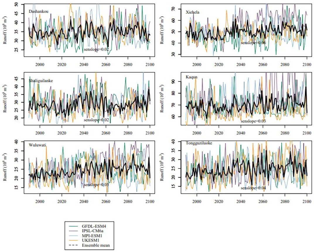
FIGURE 4. Runoff variations of four headstreams of the Tarim River under SSP126 scenario based on ISIMIP datasets. The colored fine lines indicate single model simulations while the black thick line is the ensemble mean.
Under the SSP585 scenario, we found that during 1990–2100, runoff in the Aksu River increased by 0.02 × 10⁸ m3/year (the Kumarak and Toshgan rivers both increased at a rate of 0.01 × 10⁸ m3/year), while runoff in the Yarkand River and the Hotan River increased at a rate of 0.03 × 10⁸ m3 and 0.11 × 10⁸ m3 per year, respectively (Figure 5).
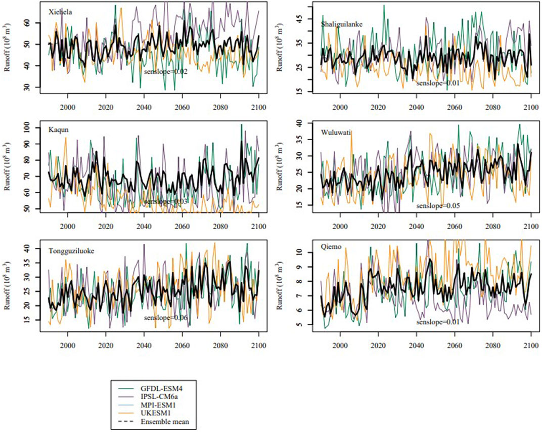
FIGURE 5. Runoff variations of four headstreams of the Tarim River under SSP585 scenario based on ISIMIP datasets. The colored fine lines indicate single model simulations while the black thick line is the ensemble mean.
3.3.3 Forecast of future change trends in melt runoff
Based on the GloGEM, this study calculated the changes in glacier melt runoff in the Tarim River Basin (Zhao et al., 2023). Under global warming, the increase in temperature significantly influenced the glacier meltwater in the Tarim River Basin. Under the SSP126 scenario, the tipping point of glacier melt in the basin may occur around 2058, while under the SSP370 and SSP585 scenarios, it is anticipated to occur around 2080. For the Aksu River, the tipping point of the glacier melting runoff is around 2040–2050 (Figure 6). Under the SSP126 scenario, the Tarim River runoff may be lower than or equal to the historical period by the end of the 21st century. And the runoff in the Yarkand and Hotan rivers will show a continuous increasing trend. However, compared with the beginning of the 21st century, the runoff presents a slight decrease (7%) only under RCP2.6 scenario, whereas the runoff will increase under other scenarios.
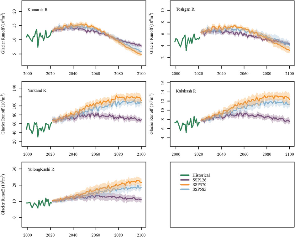
FIGURE 6. Future changes in glacier meltwater runoff in the headwaters of the Tarim River. The shaded area represents the multiple model mean ± standard deviation.
4 Discussion
The Tarim River Basin is China’s largest inland basin, and nearly all the water resources come from the mountainous areas. However, climate change is impacting the hydrological processes by affecting the precipitation and runoff generation processes, as well as the melting of glaciers and snow and underlying surface changes (e.g., frozen soil, landuse), thus altering annual and seasonal variations of water resources across the basin. For example, the vegetation in the mountainous watershed of the Kaidu River is lush and expansive. When the temperature rises, vegetation transpiration increases substantially and consumes large amount of water. This may lead to a decreasing trend in the runoff in the middle to late 21st century for the Kaidu river. The simulated increase in runoff is largely caused by increased glacier meltwater in the mountains. However, the glacier retreat in the Tarim River Basin is obvious, which will lead to enhanced hydrological fluctuations considering the intensified climate extremes (Fang et al., 2022; Zhang et al., 2022).
Under the SSP126 and SSP370 scenarios, the runoff in the Aksu River shows an increasing trend, while under the SSP585 scenario, the runoff shows a weak decreasing trend after 2066. Except for the SSP370 scenario, runoff in the Yarkand River basically maintains a high variation and increasing trend. Similarly, the future runoff of the Hotan River, which originates from the northern slope of the Kunlun Mountain, also presents a high variation and increasing trend. Compared with previous study, the results are inconsistent with results projected by two glacio-hydrological models forced by eight GCMs, that river discharge is projected to first increase by about 20% in the Aksu River catchment with subsequent decrease of up to 20%, while the Hotan and Yarkand catchments is projected to increase by 15%–60% towards the end of the century (Wortmann et al., 2022). Some studies also projected a slightly decrease in runoff with increase spring and winter runoff in the end of the 21st century (Liu et al., 2013). Note that the direction of changes in the Kaidu River is debated with both increasing trend (Zhang et al., 2017; Ren et al., 2018; Wang et al., 2018) and decreasing trend (Liu et al., 2011; Xu et al., 2016; Luo et al., 2018; Huang et al., 2020). The future runoff in the Yarkand and Hotan rivers is basically in an increasing trend with different magnitude (Zhang et al., 2012; Luo et al., 2018; Su et al., 2022). The runoff in the Aksu River will increase in the near future but will decrease in the end of the 21st century with the dramatic decrease in glacier area (Duethmann et al., 2016; Wang et al., 2018; Huang, 2019).
From the future projection of glacier melt runoff, the tipping point of glacier meltwater runoff in the Tarim River Basin will likely occur within the next 10–30 years. After that, the runoff will remain at a high level, mainly because of the increase in mountainous precipitation. Under the influence of steady warming, the huge tongues of the glaciers will likely melt and recede, but a certain amount of glacial meltwater will still be generated to maintain the stability of the runoff. The timing of peak water varying globally. For glacier-fed rivers with predominantly smaller glaciers, for example, in the tropical Andes (Frans et al., 2015; Polk et al., 2017), Western Canada (Fleming and Dahlke, 2014) and the Swiss Alps (Huss and Fischer, 2016), the peak water has been reached before 2019. For the High Mountain Asia, the European Alps, and Western Canada and United States , the peak water will generally be reached before or around the middle of the century (IPCC, 2019). We have to admit that the timing of peak water varies for different circulation conditions and glacier characteristics.
Note that there is some uncertainty regarding future runoff in large basins with numerous glaciers. The changing pattern of runoff in the future presents challenges, especially considering potential underestimation of evapotranspiration due to vegetation changes, altered routine processes resulting from glacier retreat, and other factors. To address this challenge, it is strongly recommended to incorporate more physical processes into the modeling approach.
5 Conclusion
Global warming has led to changes in glacier and snow meltwater and therefore changes the runoff in the Tarim River Basin. This paper assessed the future changes in runoff in the Tarim River Basin based on multi-model ensemble including SWAT-Glacier, H08 and GloGEM. The following conclusions can be drawn.
(1) The runoff from the mountains in the Tarim River Basin showed an overall increasing trend. For more than half a century (1957–2022), the runoff in the mountainous area in the Kaidu, Aksu, Yarkand, and Hotan rivers increased at a rate of 2.56 × 10⁸ m3, 2.06 × 10⁸ m3, 2.11 × 10⁸ m3, and 1.12 × 10⁸ m3 per decade, respectively. The runoff increased by 40.7 × 10⁸ m3 during 1957–2022.
(2) There is a close relationship between runoff change and climate change in the Tarim River Basin. During the historical period (1957–2022), both the temperature and the precipitation increased. Warmer temperatures accelerated both the evapotranspiration and the glacier melt, leading to changes in runoff. The rise in precipitation had a positive effect on river runoff. Under global warming, the hydrological fluctuations will further increase.
(3) Under the RCP4.5 and RCP8.5 scenarios, future runoff in the Tarim River shows an increasing trend. Up to 2035, the runoff in the Kaidu, Aksu, Yarkand, and Hotan rivers will likely remain at a high level, with an average increase of around 3.2%–7.55%. In the mid 21st century (2036–2065), the runoff of the Yarkand and Hotan rivers originating in the Kunlun and Karakoram mountains is expected to follow an increasing trend of around 6.25%–15.2%. According to the prediction results of the global hydrological model H08, the runoff is expected to increase during the mid 21st century under the SSP126 and SSP585 scenarios. Under the SSP126 scenario, the tipping point of glacier melt runoff in the basin may occur around 2058, while under the SSP370 and SSP585 scenarios, it may occur around 2080. The timing of peak water in the Yarkand and Hotan rivers aligns well with previous projections in mountainous Asia, where the presence of large glaciers is a contributing factor. However, it occurs much later compared to the tropical Andes, Western Canada, and the Swiss Alps, where peak water has been already reached before 2019.
Data availability statement
The datasets presented in this study can be found in online repositories. The names of the repository/repositories and accession number(s) can be found in the article.
Author contributions
XG: Writing–original draft preparation, Visualization, Investigation. GF: Analysis and interpretation of data. YC: Conception and design of the work. XZ: Acquisition and processing of data. GF and YC: Conceptualization, Writing–review and editing. All authors contributed to the article and approved the submitted version.
Funding
The research is supported by the National Natural Science Foundation of China (grant numbers U1903208 and 42071046), the Open Project of Key Laboratory of Xinjiang, China (grant number 2022D04043) and Xinjiang Natural Science Foundation (grant number 2022D01A348).
Conflict of interest
The authors declare that the research was conducted in the absence of any commercial or financial relationships that could be construed as a potential conflict of interest.
The reviewer HW and XL declared a shared affiliation with the author XG to the handling editor at time of review.
Publisher’s note
All claims expressed in this article are solely those of the authors and do not necessarily represent those of their affiliated organizations, or those of the publisher, the editors and the reviewers. Any product that may be evaluated in this article, or claim that may be made by its manufacturer, is not guaranteed or endorsed by the publisher.
References
Ban, C., Tao, H., Dong, Y., and Zhao, C. (2018). “Simulation of daily runoff process in the mainstream area of the Tarim River under future climate scenario,” in Arid zone research (Berlin, Germany: Springer).
Bolch, T., Duethmann, D., Wortmann, M., Liu, S., and Disse, M. (2022). Declining glaciers endanger sustainable development of the oases along the Aksu-Tarim River (Central Asia). Int. J. Sustain. Dev. World Ecol. 29, 209–218. doi:10.1080/13504509.2021.1943723
Chen, H., Chen, Y., Li, W., and Li, Z. (2019). Quantifying the contributions of snow/glacier meltwater to river runoff in the Tianshan Mountains, Central Asia. Glob. Planet. change 174, 47–57. doi:10.1016/j.gloplacha.2019.01.002
Chen, Y. (2014). Water resources research in Northwest China. Berlin, Germany: Springer Science & Business Media.
Chen, Y. (2015). Ecological protection and sustainable management of the Tarim River Basin. Beijing: Science press.
Chen, Y., Li, Z., Xu, J., Shen, Y., Xing, X., Xie, T., et al. (2023). Changes and protection suggestions in water resources and ecological environment in arid region of northwest China. Bull. Chin. Acad. Sci. 38, 385–393. doi:10.16418/j.issn.1000-3045.20230120005
Chen, Y., Takeuchi, K., Xu, C., Chen, Y., and Xu, Z. (2006). Regional climate change and its effects on river runoff in the Tarim Basin, China. Hydrol. Process. 20, 2207–2216. doi:10.1002/hyp.6200
Chen, Y., Xu, C., Hao, X., Li, W., Chen, Y., Zhu, C., et al. (2009). Fifty-year climate change and its effect on annual runoff in the Tarim River Basin, China. Quat. Int. 208, 53–61. doi:10.1016/j.quaint.2008.11.011
Duethmann, D., Bolch, T., Farinotti, D., Kriegel, D., Vorogushyn, S., Merz, B., et al. (2015). Attribution of streamflow trends in snow and glacier melt-dominated catchments of the Tarim River, Central Asia. Water Resour. Res. 51, 4727–4750. doi:10.1002/2014wr016716
Duethmann, D., Menz, C., Jiang, T., and Vorogushyn, S. (2016). Projections for headwater catchments of the Tarim River reveal glacier retreat and decreasing surface water availability but uncertainties are large. Environ. Res. Lett. 11, 054024. doi:10.1088/1748-9326/11/5/054024
Fang, G., Li, Z., Chen, Y., Liang, W., Zhang, X., and Zhang, Q. (2023). Projecting the impact of climate change on runoff in the Tarim River simulated by the soil and water assessment Tool Glacier Model. Remote Sens. 15, 3922. doi:10.3390/rs15163922
Fang, G., Li, Z., Yang, J., Chen, Y., Duan, W., Amory, C., et al. (2022). Changes in flooding in the alpine catchments of the Tarim River Basin, central Asia. J. Flood Risk Manag. 16, e12869. doi:10.1111/jfr3.12869
Fang, G., Yang, J., Chen, Y., Li, Z., Ji, H., and De Maeyer, P. (2018). How hydrologic processes differ spatially in a large basin: multisite and multiobjective modeling in the Tarim River Basin. J. Geophys. Res. Atmos. 123, 7098–7113. doi:10.1029/2018jd028423
Fleming, S. W., and Dahlke, H. E. (2014). Modulation of linear and nonlinear hydroclimatic dynamics by mountain glaciers in Canada and Norway: results from information-theoretic polynomial selection. Can. Water Resour. Journal/Revue Can. Des. ressources hydriques 39, 324–341. doi:10.1080/07011784.2014.942164
Frans, C., Istanbulluoglu, E., Lettenmaier, D. P., Naz, B. S., Clarke, G. K., Condom, T., et al. (2015). Predicting glacio-hydrologic change in the headwaters of the Z ongo R iver, C ordillera R eal, B olivia. Water Resour. Res. 51, 9029–9052. doi:10.1002/2014wr016728
Giorgi, F., and Gutowski, W. J. (2015). Regional dynamical downscaling and the CORDEX initiative. Annu. Rev. Environ. Resour. 40, 467–490. doi:10.1146/annurev-environ-102014-021217
Hanasaki, N., Kanae, S., Oki, T., Masuda, K., Motoya, K., Shirakawa, N., et al. (2008). An integrated model for the assessment of global water resources–Part 1: model description and input meteorological forcing. Hydrology Earth Syst. Sci. 12, 1007–1025. doi:10.5194/hess-12-1007-2008
Hock, R. (2003). Temperature index melt modelling in mountain areas. J. hydrology 282, 104–115. doi:10.1016/s0022-1694(03)00257-9
Huang, J. (2019). “Analysis of stream flow composition in glacierized inland river basin—case study from Aksu river basin,” in Analysis of stream flow composition in glacierized inland river basin—case study from Aksu river basin. Editor J. Huang (Beijing: University of Chinese Academy of Sciences).
Huang, Y., Ma, Y., Liu, T., and Luo, M. (2020). Climate change impacts on extreme flows under IPCC RCP scenarios in the mountainous Kaidu watershed, Tarim River basin. Sustainability 12, 2090. doi:10.3390/su12052090
Huss, M., and Fischer, M. (2016). Sensitivity of very small glaciers in the Swiss Alps to future climate change. Front. earth Sci. 4, 34. doi:10.3389/feart.2016.00034
IPCC (2019). in IPCC special report on the ocean and cryosphere in a changing climate. Editors H. Portner, D. C. Roberts, V. Masson-Delmotte, P. Zhai, M. Tignor, E. Poloczanskaet al. (Cambridge, UK and New York, USA: Cambridge University Press).
Liu, T., Willems, P., Pan, X. L., Bao, A. M., Chen, X., Veroustraete, F., et al. (2011). Climate change impact on water resource extremes in a headwater region of the Tarim basin in China. Hydrology Earth Syst. Sci. 15, 3511–3527. doi:10.5194/hess-15-3511-2011
Liu, Z., Xu, Z., Fu, G., and Yao, Z. (2013). Assessing the hydrological impacts of climate change in the headwater catchment of the Tarim River basin, China. Hydrology Res. 44, 834–849. doi:10.2166/nh.2012.237
Luo, Y., Wang, X., Piao, S., Sun, L., Ciais, P., Zhang, Y., et al. (2018). Contrasting streamflow regimes induced by melting glaciers across the Tien Shan – Pamir – North Karakoram. Sci. Rep. 8, 16470. doi:10.1038/s41598-018-34829-2
Neitsch, S., Arnold, J., and Kiniry, J. (2002). Soil and water assessment tool theoretical manual. Texas: Grassland Soil Water Research Laboratory.
Polk, M. H., Young, K. R., Baraer, M., Mark, B. G., Mckenzie, J. M., Bury, J., et al. (2017). Exploring hydrologic connections between tropical mountain wetlands and glacier recession in Peru's Cordillera Blanca. Appl. Geogr. 78, 94–103. doi:10.1016/j.apgeog.2016.11.004
Ren, W., Yang, T., Shi, P., Xu, C.-Y., Zhang, K., Zhou, X., et al. (2018). A probabilistic method for streamflow projection and associated uncertainty analysis in a data sparse alpine region. Glob. Planet. Change 165, 100–113. doi:10.1016/j.gloplacha.2018.03.011
Shen, Y.-J., Shen, Y., Fink, M., Kralisch, S., Chen, Y., and Brenning, A. (2018). Trends and variability in streamflow and snowmelt runoff timing in the southern Tianshan Mountains. J. Hydrology 557, 173–181. doi:10.1016/j.jhydrol.2017.12.035
Su, F., Pritchard, H. D., Yao, T., Huang, J., Ou, T., Meng, F., et al. (2022). Contrasting fate of western Third Pole's water resources under 21st century climate change. Earth's Future 10, e2022EF002776. doi:10.1029/2022ef002776
Tang, Y., Tang, Q., Wang, Z., Chiew, F. H. S., Zhang, X., and Xiao, H. (2019). Different precipitation elasticity of runoff for precipitation increase and decrease at watershed scale. J. Geophys. Res. Atmos. 124, 11932–11943. doi:10.1029/2018jd030129
Wang, A., Su, B., Huang, J., Jing, C., Kundzewicz, Z. W., Tao, H., et al. (2023). Runoff components and the contributions of precipitation and temperature in a highly glacierized river basin in Central Asia. Front. Earth Sci. 17, 361–377. doi:10.1007/s11707-022-0995-0
Wang, C., Xu, J., Chen, Y., Bai, L., and Chen, Z. (2018). A hybrid model to assess the impact of climate variability on streamflow for an ungauged mountainous basin. Clim. Dyn. 50, 2829–2844. doi:10.1007/s00382-017-3775-x
Wang, N., Liu, W., Wang, H., Sun, F., Duan, W., Li, Z., et al. (2021). Improving streamflow and flood simulations in three headwater catchments of the Tarim River based on a coupled glacier-hydrological model. J. Hydrology 603, 127048. doi:10.1016/j.jhydrol.2021.127048
Wang, N., Sun, F. B., Wang, H., and Liu, W. B. (2022). Effects of cryospheric hydrological processes on future flood inundation and the subsequent socioeconomic exposures in Central Asia. Environ. Res. Lett. 17, 124020. doi:10.1088/1748-9326/aca491
Wortmann, M., Duethmann, D., Menz, C., Bolch, T., Huang, S., Jiang, T., et al. (2022). Projected climate change and its impacts on glaciers and water resources in the headwaters of the Tarim River, NW China/Kyrgyzstan. Clim. Change 171, 30. doi:10.1007/s10584-022-03343-w
Xiang, Y., Li, L., Chen, J., Xu, C.-Y., Xia, J., Chen, H., et al. (2019). Parameter uncertainty of a snowmelt runoff model and its impact on future projections of snowmelt runoff in a data-scarce deglaciating River Basin. Water 11, 2417. doi:10.3390/w11112417
Xiang, Y., Wang, Y., Chen, Y., and Zhang, Q. (2022). Impact of climate change on the hydrological regime of the yarkant River Basin, China: an assessment using three SSP scenarios of CMIP6 GCMs. Remote Sens. 14, 115. doi:10.3390/rs14010115
Xu, C., Zhao, J., Deng, H., Fang, G., Tan, J., He, D., et al. (2016). Scenario-based runoff prediction for the Kaidu River basin of the tianshan mountains, northwest China. Environ. Earth Sci. 75, 1126. doi:10.1007/s12665-016-5930-9
Xu, Z. X., Chen, Y. N., and Li, J. Y. (2004). Impact of climate change on water resources in the Tarim River basin. Water Resour. Manag. 18, 439–458. doi:10.1023/b:warm.0000049142.95583.98
Yang, P., Xia, J., Zhang, Y., Zhan, C., and Sun, S. (2019). How is the risk of hydrological drought in the Tarim River Basin, northwest China? Sci. Total Environ. 693, 133555. doi:10.1016/j.scitotenv.2019.07.361
Yao, J., Chen, Y., Guan, X., Zhao, Y., Chen, J., and Mao, W. (2022). Recent climate and hydrological changes in a mountain–basin system in Xinjiang, China. Earth-Science Rev. 226, 103957. doi:10.1016/j.earscirev.2022.103957
Zhang, F., Li, L., and Ahmad, S. (2017). “Streamflow pattern variations resulting from future climate change in middle Tianshan Mountains region in China,” in World environmental and water resources congress 2017 (Reston, VA: American Society of Civil Engineers), 437–446.
Zhang, S., Gao, X., Zhang, X., and Hagemann, S. (2012). Projection of glacier runoff in yarkant River basin and beida River basin, western China. Hydrol. Process. 26, 2773–2781. doi:10.1002/hyp.8373
Zhang, X., Chen, Y., Fang, G., Xia, Z., Yang, Y., Duan, W., et al. (2022). Future changes in extreme precipitation from 1.0 °C more warming in the Tienshan Mountains, Central Asia. J. Hydrology 612, 128269. doi:10.1016/j.jhydrol.2022.128269
Zhao, B., Sun, H., Yan, D., Wei, G., Tuo, Y., and Zhang, W. (2021). Quantifying changes and drivers of runoff in the Kaidu River Basin associated with plausible climate scenarios. J. Hydrology Regional Stud. 38, 100968. doi:10.1016/j.ejrh.2021.100968
Keywords: runoff change, SWAT-glacier, future trend, peak water, Tarim River Basin
Citation: Gao X, Fang G, Chen Y and Zhang X (2023) Analysis of runoff variations in an arid catchment based on multi-model ensemble- a case study in the Tarim River Basin in Central Asia. Front. Earth Sci. 11:1249107. doi: 10.3389/feart.2023.1249107
Received: 28 June 2023; Accepted: 31 October 2023;
Published: 27 December 2023.
Edited by:
Zhiyuan Hu, Sun Yat-Sen University, ChinaReviewed by:
Hong Wang, Institute of Geographic Sciences and Natural Resources Research, Chinese Academy of Sciences (CAS), ChinaLeilei Min, Center for Agricultural Resources Research, Institute of Genetics and Developmental Biology, Chinese Academy of Sciences (CAS), China
Xingcai Liu, Institute of Geographic Sciences and Natural Resources Research, Chinese Academy of Sciences (CAS), China
Zhiyong Liu, Sun Yat-Sen University, China
Copyright © 2023 Gao, Fang, Chen and Zhang. This is an open-access article distributed under the terms of the Creative Commons Attribution License (CC BY). The use, distribution or reproduction in other forums is permitted, provided the original author(s) and the copyright owner(s) are credited and that the original publication in this journal is cited, in accordance with accepted academic practice. No use, distribution or reproduction is permitted which does not comply with these terms.
*Correspondence: Gonghuan Fang, fanggh@ms.xjb.ac.cn; Yaning Chen, chenyn@ms.xjb.ac.cn