Examining the variability of rock glacier meltwater in space and time in high-elevation environments of Utah, United States
 Jeffrey S. Munroe1*
  Alexander L. Handwerger2,3
- 1Department of Earth and Climate Sciences, Middlebury College, Middlebury, VT, United States
- 2Jet Propulsion Laboratory, California Institute of Technology, Pasadena, CA, United States
- 3Joint Institute for Regional Earth System Science and Engineering, University of California, Los Angeles, Los Angeles, CA, United States
Rock glaciers are common geomorphic features in alpine landscapes and comprise a potentially significant but poorly quantified water resource. This project focused on three complementary questions germane to rock glacier hydrology: 1) Does the composition of rock glacier meltwater vary from year to year? 2) How dependent is the composition of rock glacier meltwater on lithology? And 3) How does the presence of rock glaciers in a catchment change stream water chemistry? To address these questions, we deployed automated samplers to collect water from late June through mid-October 2022 in two rock-glacierized mountain ranges in Utah, United States characterized by different lithologies. In the Uinta Mountains of northern Utah, where bedrock is predominantly quartzite, water was collected at springs discharging from two rock glaciers previously shown to release water in late summer sourced from internal ice. In the La Sal Mountains of southeastern Utah, where trachyte bedrock is widespread, water was collected at a rock glacier spring, along the main stream in a watershed containing multiple rock glaciers, and from a stream in a watershed where rock glaciers are absent. Precipitation was also collected, and data loggers for water temperature and electric conductivity were deployed. Water samples were analyzed for stable isotopes with cavity ring-down spectroscopy and hydrochemistry with ICP-MS. Our data show that water discharging from rock glaciers in the Uinta Mountains exhibits a shift from a snowmelt source to an internal ice source over the course of the melt season that is consistent from year to year. We also found that the chemistry of rock glacier water in the two study areas is notably different in ways that can be linked back to their contrasting bedrock types. Finally, in the La Sal Mountains, the properties of water along the main stream in a rock-glacierized basin resemble the properties of water discharging from rock glaciers, and strongly contrast with the water in a catchment lacking rock glaciers. Collectively these results underscore the role of rock glaciers as an agent influencing the hydrochemistry of water in high-elevation stream systems.
1 Introduction
Rock glaciers are mixtures of rock debris and ice that move downslope through a combination of internal deformation and basal sliding (Wahrhaftig and Cox, 1959; Giardino et al., 1987). Common landforms in mountain environments around the world (Giardino and Vitek, 1988; Anderson et al., 2018), rock glaciers exhibit a characteristic surface morphology of ridges and furrows (Kääb and Weber, 2004), and steep terminal and side slopes where a finer matrix is exposed beneath coarser surface material (Potter, 1972). Decades of research have established that the distribution of rock glaciers conveys information about past and present climate (Blagbrough and Farkas, 1968; Nicholas and Butler, 1996; Konrad et al., 1999), that rock glacier are polygenetic features formed through the burial of glaciers or the accumulation of pore ice within blocky talus (Berthling, 2011), and that rock glaciers may be significant refugia for cold-adapted plants and animals in the face of warming mountain climates (Millar et al., 2015; Brighenti et al., 2021b). Recently, work has also begun to focus on the hydrologic importance of rock glaciers, considering their role as shallow aquifers (Giardino et al., 1992; Winkler et al., 2016; Harrington et al., 2018; Wagner et al., 2020), elucidating pathways for water passing through them (Krainer and Mostler, 2002; Harrington et al., 2018; Liaudat et al., 2020; Sileo et al., 2020), investigating the degree to which they can hinder the percolation of surface water deeper into the ground (Geiger et al., 2014), and raising the possibility that perennial ice within rock glaciers is melting as mountain temperatures warm (Caine, 2010). This latter point is particularly noteworthy given projections suggesting that rock glaciers collectively store considerable water in the form of ice within certain mountain ranges (Clow et al., 2003; Azócar and Brenning, 2010; Rangecroft et al., 2015; Janke et al., 2017; Jones et al., 2018; 2019; Munroe, 2018).
Despite the abundant evidence that active rock glaciers contain ice, and indications that this reservoir of ice is vulnerable to melting, many questions remain about how rock glaciers currently contribute to the hydrology of high-elevation environments, and the ways in which their contribution may evolve in the future (Jones et al., 2019). Crucial to addressing these uncertainties are field-based studies designed to collect water from rock-glacierized environments to constrain the properties of this water and its temporal evolution over seasonal and longer-term time scales.
This study focused on rock glaciers in the state of Utah in the western United States. The field locations were selected based on an abundance of prior work on rock glacier origin, distribution, morphology, and activity in these areas. Consideration was also given to the dominant bedrock lithologies to support the opportunity to examine the role of lithology in influencing rock glacier melt water chemistry. Time-series of water samples were collected starting early in the melt season of 2022 and continuing until freeze-up in October. Samples were analyzed for stable isotopes and hydrochemistry and the results were used to address three complementary questions: 1) Does the composition of rock glacier meltwater vary from year to year? 2) How dependent is the composition of rock glacier meltwater on lithology? And 3) How does the presence of rock glaciers in a catchment change stream water chemistry?
2 Setting
Fieldwork for this project was conducted in two different mountain ranges (Figure 1A). The Uinta Mountains in northeastern Utah are a Laramide-age uplift of Precambrian quartzite with subordinate argillite that is part of the Rocky Mountain physiographic province. These mountains were extensively glaciated during the Pleistocene, but alpine glaciers disappeared at the Pleistocene-Holocene transition (Munroe and Laabs, 2017). Maximum summit elevations in the Uintas are in excess of 4 km and elevations above ∼3,100 m have mean annual air temperatures <0°C (Munroe and Mickelson, 2002; Munroe, 2006) and likely host modern permafrost (Obu et al., 2019). On the basis of interpolated data (PRISM Climate Group, 2023), mean annual air temperature and precipitation at locations of the two Uinta rock glaciers studied here average around −0.7°C and 840 mm. Previous work has inventoried rock glaciers in the Uintas (Munroe, 2018; Brencher et al., 2021; Johnson et al., 2021), characterized their motion over seasonal and multi-annual time scales (Brencher et al., 2021), and examined their hydrologic significance (Munroe and Handwerger, 2022).
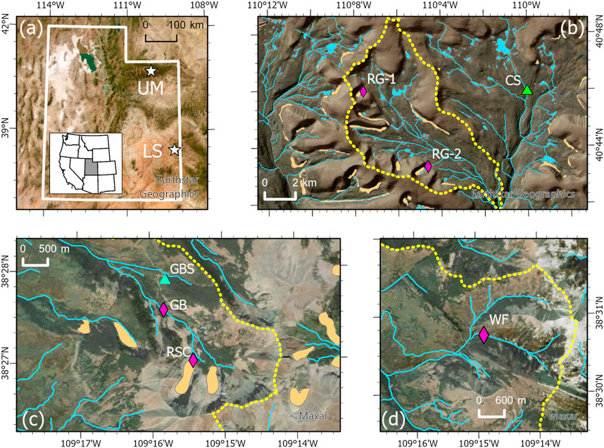
FIGURE 1. (A) Locations of the Uinta Mountains (UM) and the La Sal Mountains (LS) in the state of Utah, United States (white stars). Background is a true color satellite composite from Earthstar Geographics. (B) Map of the study area in the West Fork Whiterocks River drainage in the Uinta Mountains. The watershed boundary is shown by the yellow dashed line. Light orange polygons are mapped rock glaciers. The studied rock glaciers and their associated water samplers (purple diamonds) are labeled, RG-1 and RG-2. The green triangle marks the Chepeta SNOTEL site (CS). Background is a true color satellite composite from Earthstar Geographics. (C) Map of the Gold Basin study area in the La Sal Mountains. The watershed boundary is shown by the yellow dashed line. Light orange polygons are mapped rock glaciers. The water sampler at the toe of the Red Snow Cirque (RSC) rock glacier is shown by the purple diamond, as is the downstream sampler GB. The green triangle marks the Gold Basin SNOTEL site (GBS). Background is a true color satellite composite from Maxar. (D) Map of the Wet Fork study area in the La Sal Mountains. The watershed boundary is shown by the yellow dashed line. The location of the Wet Fork water sampler (WF) is marked by the purple diamond. There are no rock glaciers in this drainage. Background is a true color satellite composite from Maxar.
Work was also conducted in the La Sal Mountains of southeastern Utah (Figure 1A). These laccolithic bodies of Oligocene trachyte (Hunt and Waters, 1958; Ross et al., 1998) surrounded by silicilastic rocks reach elevations >3,800 m, rising above the Canyonlands of the Colorado Plateau. The La Sals were also glaciated repeatedly in the Pleistocene (Richmond, 1962), but no glaciers remain in these mountains today and mean annual air temperatures at all elevations are >0°C. The location of the rock glacier studied in the La Sals is warmer and wetter than the two sites in the Uintas, with mean annual temperature and precipitation of 2.4°C and 1,035 mm (PRISM Climate Group, 2023). Rock glaciers in the La Sals have been the focus of considerable prior study. Fabric analysis and geographic analysis have emphasized the role of rockfall and snow avalanching in sustaining rock glaciers (Nicholas, 1994; Nicholas and Garcia, 1997). Relative age dating techniques have estimated late Holocene ages for many of these features (Nicholas and Butler, 1996). Hydrologic studies employing a paired watershed approach demonstrated increased surface runoff from basins containing rock glaciers, emphasizing that rock glaciers can act as impervious surfaces that effect downstream hydrographs (Geiger et al., 2014). Finally, optical and radar remote sensing have identified >40 active and transitional rock glaciers throughout the range, and revealed that they are moving several cm each year (Johnson et al., 2021; Kluetmeier et al., 2022).
3 Materials and methods
3.1 Field sites and methods
Central to the field component of this project was deployment of five automated samplers to collect time series of water samples. The samplers contain a carousel of 24, 500-mL bottles, a pump and distributor arm, and a control module (Figure 2). A solar panel was used to maintain charge on a 12 V battery to run each sampler continuously through the melt season. Sample bottles were modified following published methodology (von Freyberg et al., 2020) to reduce the potential for evaporation to fractionate stable isotopes within the sampler. Samplers were deployed in positions higher than their intake to permit free draining of the intake line, and the sampling inlet was wrapped in 100-µm nylon mesh to prevent coarse material from clogging the pump. All samplers were programmed to collect a 45-mL sample at midnight and noon each day. For 3 days these samples (six samples total) were composited in a single bottle. The carousel of 24 bottles allowed each sampler to run unattended for 72 days, collecting long series of composited samples spanning the melt season.
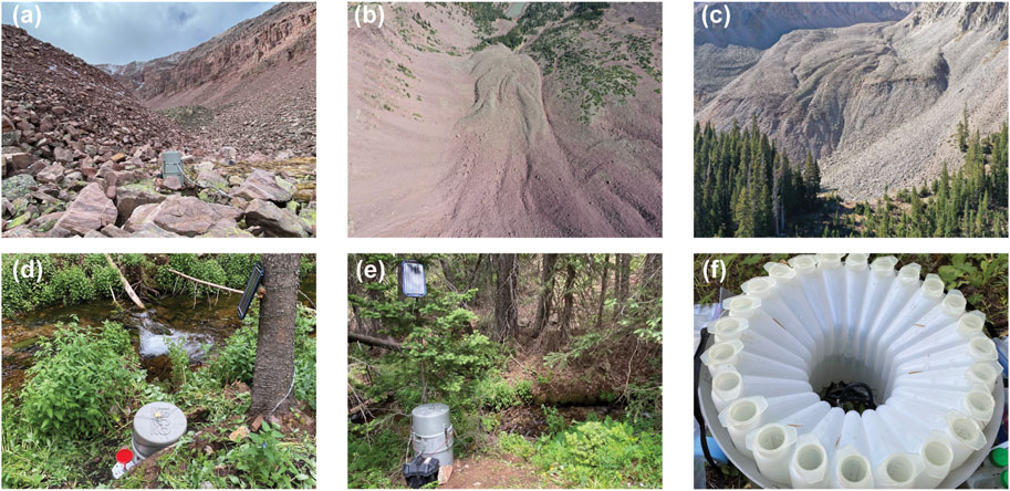
FIGURE 2. Photographs of study sites and methodology. (A) Photograph of the automated water sampler deployed at the terminus of the RG-1 rock glacier. (B) Photograph of the RG-2 rock glacier collected from an uncrewed aerial vehicle (UAV). (C) Oblique photograph of the terminus of the RSC rock glacier in the La Sal Mountains from a UAV. (D) Photograph of the GB water sampler in the La Sal Mountains. The sampler drew water directly from the stream and the battery system was charged by the solar panel mounted on the tree. The red funnel is the top of the precipitation sampler. (E) Photograph of the WF sampler along the Wet Fork Mill Creek (background) in the La Sal Mountains. (F) Photograph showing the carousel of 24, 500-mL bottles within the water sampler.
In the Uinta Mountains (Figure 1B), two samplers were installed at springs discharging from the termini of rock glaciers RG-1 and RG-2 (Figures 2A, B) that were the targets of previous study (Munroe, 2018; Munroe and Handwerger, 2022). RG-1 and RG-2 are tongue-shaped rock glaciers ∼600 m long and ∼100 m wide that are typical of cirque-floor features in these mountains. Both are defined by steep terminal and side slopes ∼20 m tall that exhibit a bilevel stratigraphy of finer material beneath a surface mantle of coarse quartzite boulders. Satellite InSAR (interferometric synthetic aperture radar) analysis indicates that these features move at velocities of ∼10 cm/yr during the summer (Brencher et al., 2021). The springs at the termini of these rock glaciers discharge water with a temperature <1°C consistently through the melt season.
In the La Sal Mountains, three water samplers were deployed (Figures 1, 2). One was positioned at a spring discharging directly from the terminus of the rock glacier in Red Snow Cirque (RSC, Figures 1C, 2C). A second sampler was installed ∼1 km downstream from the RSC sampler along the main stream draining Gold Basin (GB, Figures 1C, 2D). A third sampler was deployed on the Wet Fork of Mill Creek (WF Figures 1D, 2E), which drains a subalpine basin in which rock glaciers are absent. The GB and WF samplers were located at the points where a previous study measured discharge to investigate how the presence of rock glaciers impacts stream hydrographs (Geiger et al., 2014).
To complement the series of composite water samples, automated data loggers were installed at RG-2 in the Uinta Mountains and at RSC in the La Sal Mountains to measure water temperature and specific conductivity every hour for the duration of the water sampler deployment.
To provide information about the properties of precipitation near the water samplers, grab samples of snow were collected on the surfaces of RG-1, RG-2, and GB when the water samplers were deployed. Rain was collected during the deployment period at RG-2, RSC, GB, and WF using samplers designed to eliminate isotope fractionation due to evaporation (Gröning et al., 2012). These rain collectors were deployed within 10 m of the water samplers. Timing and magnitude of precipitation events are constrained by hourly data from automated SNOTEL (snowpack telemetry) sites in each study location. The Chepeta SNOTEL is located <10 km from RG-1 and RG-2 at a similar elevation (Figure 1B), and in the La Sal Mountains, the Gold Basin SNOTEL (GBS) is at a similar elevation <2 km from RSC and GB (Figure 1C).
Deep, long-lasting snowpack renders these locations inaccessible for much of the year, so the water samplers were installed in late June and early July 2022 (Table 1). All five were emptied in early September, and relaunched to run until mid-October, when they were emptied again and deactivated for the winter. The precipitation samplers were emptied in September and again in October. The dataloggers were downloaded in October. All samples for stable isotope analysis were transported from the field in new 15-mL centrifuge tubes, kept cool during shipping, and stored in a refrigerator immediately upon arrival in the laboratory.
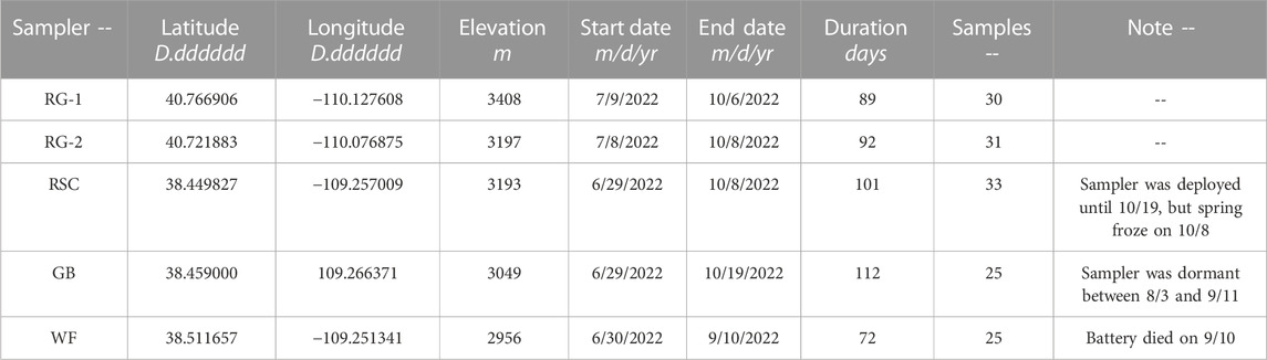
TABLE 1. Sampler locations and deployment durations.
3.2 Laboratory analyses
In the Department of Earth and Climate Sciences at Middlebury College, samples for isotope analysis were filtered to 0.2 µm and stored in glass vials with Teflon-lined caps. Samples for ICP-MS analysis were vacuum filtered with Whatman Number 1 paper and acidified to pH 2 with trace-element grade HNO3.
Stable isotope measurements were made with a Los Gatos 45-EP Triple Liquid Water Isotope Analyzer. Accuracy of the instrument is 0.4‰ for δD and 0.1‰ for δ18O. Samples were run against a bracketing set of 4 standards and calibrated with a cubic spline function relative to Standard Mean Ocean Water (SMOW). Each sample was analyzed 10 times, and the first 2 injections were discarded to minimize cross-over. Additional standards were run as unknowns as an internal check on the results. Results were compared with the Global Meteoric Water Line (GMWL) (Craig, 1961). Values of d-excess were calculated as d-excess = δD-(8 × δ18O) (Dansgaard, 1964).
Hydrochemical characterizations were made with a Thermo iCap ICP-MS. Samples were run against standards derived from NIST Standard Reference Material 1643f “Trace Elements in Water”. An in-house standard was used to determine the abundance of Si and Ti, which are not present in 1643f. Standards were run after every 10 unknowns and a linear correction was applied to compensate for instrument drift. Interpretation focused on elements that consistently exhibited concentrations >1 ppb.
Isotope data were calibrated using Los Gatos Research LWIA Post Analysis Software v.4.5.0.6. Principal component analysis in SPSS v.28.0 using a varimax rotation was employed to reduce the hydrochemical data. Datalogger datasets were filtered to average daily values in Hoboware Pro v.3.7 and exported as.csv files.
4 Results
The two samplers in the Uintas and the RSC sampler in the La Sals operated without interruption through the summer, collecting 30 and 31 samples respectively (Table 1). The RSC sampler in the La Sals also ran without interruption, however the water level dropped below the intake briefly in late September, producing a gap towards the end of the time series of 33 samples. The GB sampler experienced an error in early August and went into a dormant mode until it was relaunched in early September. It collected 25 samples before and after the error. The battery for the WF sampler failed in mid-September, ending collection for the year after a total of 25 samples had been collected.
The water samples collected in this project are depleted relative to SMOW (Figure 3; Table 2). Overall values of δD range from −111.04 to −67.52‰, whereas δ18O ranges from −15.98 to −10.40‰. The most depleted mean values were at the WF sampler, whereas the least depleted values were at RG-1. Isotope values exhibit the least variability through the melt season at WF, with the greatest range at RSC and RG-1. The spread of values at GB and RG-2 fall between these extremes. Values of δD and δ18O are linearly related and this relationship is particularly strong at GB, RSC, and RG-1 (Figure 3).
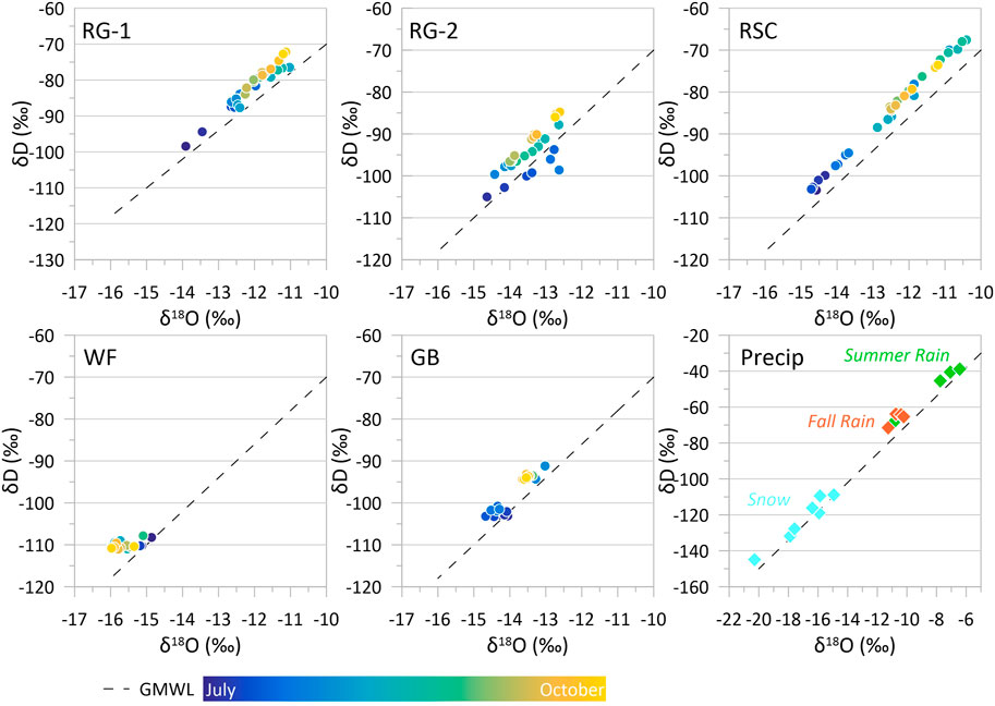
FIGURE 3. Plots of δ18O vs. δD for RG-1 and RG-2 in the Uinta Mountains; RSC, GB, and WF in the La Sal Mountains; and precipitation collected at both sites. Dashed line marks the global meteoric water line for reference (Craig, 1961). Colored symbols for the five water samplers correspond with the month of collection.
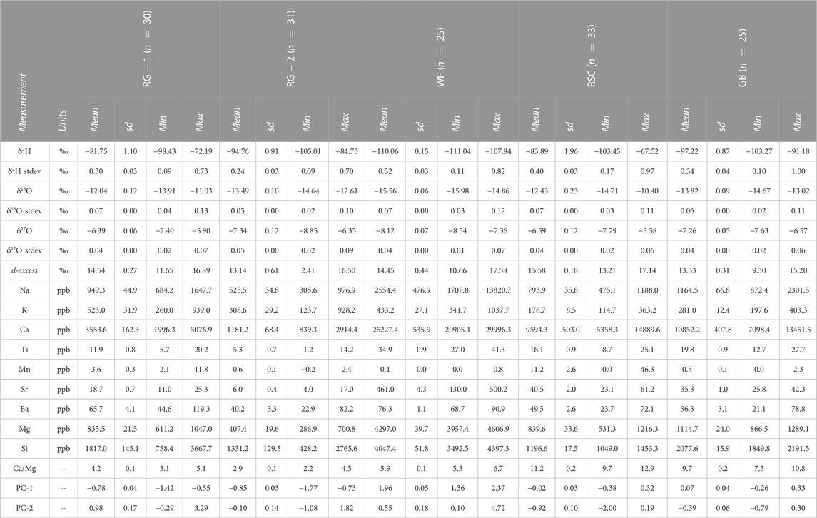
TABLE 2. Summary statistics for Isotopic and Geochemical Analyses.
Values of δD and δ18O in precipitation are also depleted relative to SMOW (Figure 3). The most negative values are found in snow samples, with δ18O reaching −20.3‰ at GB and averaging −16.4‰ in the Uintas. Values are less depleted in rain samples; in the Uintas values for both summer and fall rain are near −10.8‰. In contrast, in the three samplers from the La Sals, summer precipitation is less depleted, with δ18O averaging −7.1‰, in comparison with fall precipitation that averages −10.6‰. On a plot of δD and δ18O, values in precipitation are linearly related with a slope of 6.7 and a y-intercept of 5.6‰. Given the strong correspondence between the two isotope measurements in all water samples, presentation and discussion from this point forward will primarily focus on values of δ18O.
Isotope values vary over the duration of the melt season at all sites except for WF. At the Uinta rock glaciers, values of δ18O start near −14‰ and rise to around −12‰ by October (Figure 4). Two notable but transient spikes to less negative values are superimposed on this overall rise, one in July and another in late August. At the RSC site in the La Sals values also rise from a start near −14.5‰ to nearly −11‰ in October (Figure 5). Once again, two prominent intervals of higher values are superimposed on this rising pattern. The record from the GB sampler also starts near −14‰ and captures the rising part of the first transient departure; unfortunately the second peak occurred during the time when the sampler was dormant. The WF sampler exhibits a different pattern entirely, with values staying between −15 and −16‰ for the entire duration (Figure 5).
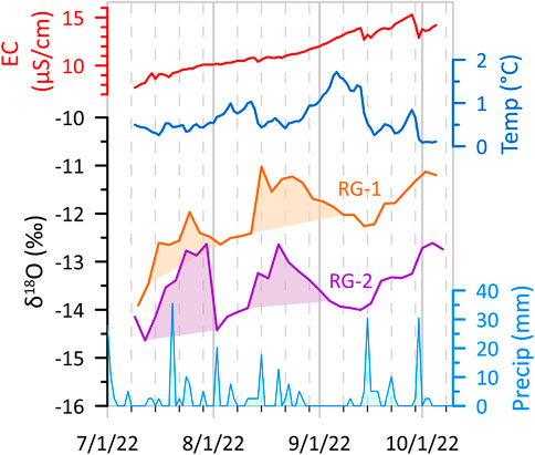
FIGURE 4. Timeline of δ18O values from the RG-1 and RG-2 water samplers in the Uinta Mountains through the melt season of 2022. Both records contain two obvious spikes to less negative values that correspond with precipitation events at the nearby Chepeta SNOTEL site (bottom). Daily electric conductivity (EC) in µS/cm (red line) and water temperature (blue line) at RG-2 are also presented.
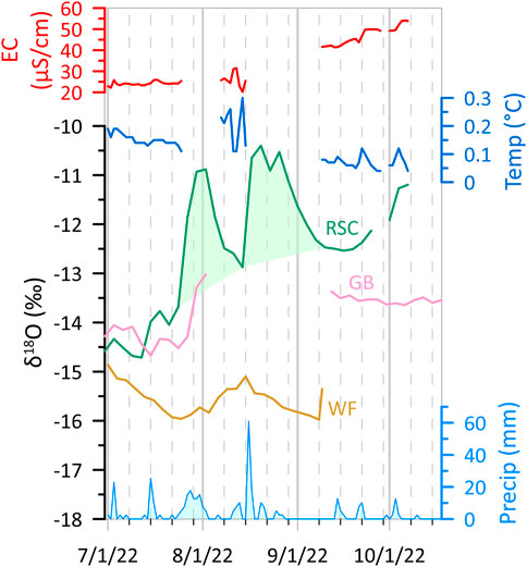
FIGURE 5. Timeline of δ18O values from the RSC, GB, and WF water samplers in the La Sal Mountains through the melt season of 2022. The RSC record, which is the most complete, contains two prominent spikes to less negative values that correspond with precipitation events at the nearby Gold Basin SNOTEL. The GB sampler experienced an error after the start of the first major precipitation event and was dormant until early September. The WF sampler stopped running in early September. Daily electric conductivity (EC) in µS/cm (red line) and water temperature (blue line) at RSC are also presented.
The data loggers reveal that daily average values of electric conductivity (EC) rise steadily through the melt season. At RG-2, values start near 8 μS/cm and double by early October (Figure 4). Values are greater at RSC, starting around 22 μS/cm and more than doubling to nearly 55 μS/cm in early October (Figure 5). In contrast, water temperatures at these sites were consistent throughout the melt season. Values remained <1°C at RG-2 except for a spike to 1.5°C in early September, and were always <0.2°C at RSC (Figures 4, 5).
The most abundant cation measured in the total set of water samples is Ca, with an average abundance of 10,082 ppb (Table 2). Si, Mg, and Na all have average abundances >1000 ppb. K and Sr average 100–350 ppb, and Ba, Ti, and Mn are <100 ppb. On a site-by-site basis, Ca is most abundant at WF (averaging 25,227 ppb), followed by GB and RSC (averaging 10,000 ppb). Values are Ca are considerably lower at RG-1 (3,553 ppb) and RG-2 (1,181 ppb) in the Uinta Mountains. Generally similar patterns are seen for other elements, although values for Si are similar for all sites except for WF. Ca/Mg ratios vary notably between the sites, averaging ∼3 in the Uintas, 5.9 at WF, 9.7 at GB, and 11.2 at RSC. Principal component analysis loads Ca, Mg, Sr, Ti, and Si on PC-1 (60.3% of the variance) and K, Ba, and Na on PC-2 (14.5%). A biplot reveals that the two Uinta sites (RG-1 and RG-2) are nearly identical, the RSC and GB sites overlap in a separate field, and WF plots far from the others in a zone of high PC-1 values (Figure 6).
FIGURE 6. Biplot of the first and second principal components determined for the hydrochemical data generated in this study. PC-1 (60.3% of the variance) consists of Ca, Mg, Sr, Ti, and Si. PC-2 (14.5%) consists of K, Ba, and Na.
The sequential nature of the samples reveals the hydrochemical evolution of these springs and streams through the melt season (Figure 7). The abundance of Ca rises steadily in an overlapping range at RSC and GB. Values also rise at WF, but in a range ∼4x higher. In contrast, values of Ca are somewhat more consistent at RG-1 and RG-2. Values of Mg rise at all sites, with again the highest values at WF. The ratio Ca/Mg increases steadily through the sampling period at RSC and GB, with a less pronounced rise at WF. In contrast, this ratio decreases at RG-1 and RG-2.

FIGURE 7. Time series of Ca, Mg, and Ca/Mg for the RG-1 and RG-2 water samplers in the Uinta Mountains, and RSC, GB, and WF in the La Sal Mountains.
5 Discussion
5.1 Rock glacier water sources
The time series of water samples collected from RG-1, RG-2, and RSC reveal that these systems evolve between different primary water sources as the melt season progresses. In early summer, water discharging from the rock glaciers has depleted isotope values consistent with a source dominated by melting snow (Table 2). This interpretation is logical given observations of lingering snow on the surface of the rock glaciers when the water samplers were deployed in late June/early July (Table 1), and similar situations have been reported for other rock glaciers (Krainer and Mostler, 2002). As the summer progresses this visible snow disappears, and a water source with less negative values of δ18O becomes more significant (Figure 3). Transient excursions of isotopes to higher values corresponding to major precipitation events are clear (Figures 4, 5), and are logical given the amount of rain and the less depleted signature of rain from the precipitation collectors (Figure 3). However, the spikes in δ18O corresponding to precipitation dissipate in <2 weeks, indicating relatively rapid drainage of water through the system (Krainer et al., 2007), and are superimposed on an overall trend of rising isotope values as the influence of snowmelt wanes (Krainer and Mostler, 2002). Electric conductivity, along with abundances of Ca and Mg, rises through the summer, which could indicate that water in late summer spends more time in contact with fresh weatherable minerals within the rock glacier, as has been noted in prior studies (Caine, 2010). Given the geochemical stability of the quartzite, these weatherable minerals may be sourced from the trace amounts of argillite present in the rock glacier catchment or from the deposition of eolian dust (Litaor, 2022), which is known to impact the Uintas (Munroe, 2014; Munroe, 2022). Ratios of Ca/Mg also shift during the melt season, dropping slightly in the Uinta rock glaciers and rising in the La Sals. This pattern requires that the sources of water are changing, not just their proportions. Additionally, the maintenance of cold (<1°C) temperatures in the rock glacier discharge indicates that these systems are thermally buffered throughout the summer, likely due to the presence of internal ice within the rock glacier (Berger et al., 2004; Brighenti et al., 2021a). High values of d-excess in the rock glacier water are consistent with the melting of ice that has undergone multiple freeze-thaw cycles (Steig et al., 1998; Williams et al., 2006). Collectively, these observations support the interpretation that water discharging from rock glacier springs in early summer is dominated by snowmelt, that internal ice becomes important as the melt season progresses, and that summer precipitation events drain rapidly through the system causing short-term changes in water characteristics that fade over the course of a few days to at most a few weeks.
5.2 Interannual variability
During the melt season of 2022 the RG-1 and RG-2 water samplers were deployed in the same locations as for a previous study in 2021 (Munroe and Handwerger, 2022). Inter-comparison of these datasets, therefore, allows the interannual stability of the hydrochemical trends in rock glacier water to be considered (Figures 8, 9). Overall, δ18O and d-excess followed similar patterns in 2021 and 2022 (Figure 9). Values of both are low at the beginning of the melt season and exhibit a steady rise upon which transient increases related to precipitation are superimposed, similar to findings reported by previous studies (Krainer and Mostler, 2002; Krainer et al., 2007). Values of δ18O are similar to snow in late June and early July, and the tendency of values at RG-1 to be slightly higher than RG-2 is present in both years. Values of d-excess start close to 10 and rise to ≥16‰ in both seasons. Short term decreases in d-excess align with major precipitation events, particularly in the 2022 record from RG-2 (Figure 9).

FIGURE 8. Schematic diagram illustrating how the time series of water samples collected in the Uinta and La Sal Mountains are used to address 3 complementary questions. The interannual consistency of the hydrochemistry of rock glacier water can be addressed using the data presented here from RG-1 and RG-2 along with data from these same sites collected in 2021 (Munroe and Handwerger, 2022). The role of lithology is addressed by comparing the data from the quartzite-dominated Uinta Mountains with the trachyte-dominated La Sal Mountains. The impact of rock glaciers on the overall hydrochemistry of a catchment can be studied in the La Sal Mountains where the RSC and GB time series are from a rock-glacierized watershed, and the WF sampler is from a watershed lacking rock glaciers.
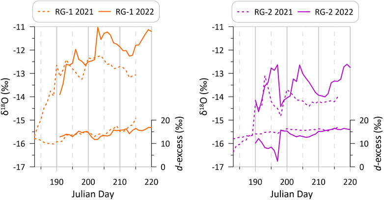
FIGURE 9. Time series of δ18O and d-excess through the melt seasons of 2021 (Munroe and Handwerger, 2022) and 2022 at RG-1 and RG-2 in the Uinta Mountains illustrating the general constancy of the pattern of rising values over multiple years.
In a key study to consider multiple years of water chemistry from the same rock glacier springs (Brighenti et al., 2021a), found that patterns of changing EC and hydrochemistry occurred with a similar timing during each melt season, with the magnitude of EC elevation and trace element enrichment corresponding with the date when snowmelt ended and with peak summer temperatures. In this regard it is notable that at the Chepeta SNOTEL site near RG-1 and RG-2, peak snow water equivalent (SWE) was nearly identical in the spring of 2021 (270 mm) and the spring of 2022 (287 mm), therefore although the exact date when snowmelt ended each year is unknown, it likely occurred at a similar time. The overall 2022 water year was wetter than 2021; by 1 July 2022, a total of 544 mm of water had fallen at Chepeta during the preceding 9 months, in contrast to 401 mm at that point in 2021. However, the generally consistent patterns in stable isotopes through these two summers in the Uintas (Figure 9) indicate that the seasonal evolution of rock glacier meltwater is controlled more by when snowmelt ends and less by absolute amounts of precipitation.
5.3 Influence of lithology
The two contrasting rock types in the locations where the water samplers for this project were deployed permit the influence of lithology on rock glacier water chemistry to be assessed (Figure 8). In the quartzite terrane of the Uintas, EC is consistently lower than in the igneous terrane of the La Sals (Figures 4, 5). Even though EC values rise through the summer at both RG-2 and RSC, peak values at RG-2 (15 μS/cm) are still below the lowest values at RSC (∼25 μS/cm). Values of Ca and Mg are also notably different between the two sites (Figure 7). In the Uintas, Ca is consistently <5,000 ppb, whereas at the RSC site in the La Sals, Ca starts around 5000 and rises to 15,000 ppb by October. Values of Ca/Mg are also considerably different, averaging 3 in the Uintas in contrast to >10 at RSC. The clearest illustration of the role of lithology is seen in the biplot of principal components determined for the hydrochemical data (Figure 6). The Uinta sites (RG-1 and RG-2) plot in an overlapping field that is completely separate from the La Sal rock glacier (RSC) and the sampler slightly downstream in Gold Basin (GB). The complete lack of overlap between the samples from the two sites emphasizes the significant role played by lithology in controlling the hydrochemistry of rock glacier water.
Previous work has come to similar conclusions regarding the importance of lithology in controlling the chemical characteristics of rock glacier meltwater. For example, the tendency of rock glaciers to alter the properties of water flowing through them has been established by field studies (Giardino et al., 1992). High concentrations of metals have been noted in the water draining from rock glaciers (Thies et al., 2017; Liaudat et al., 2020), and rock glaciers have been reported as sources of acid rock drainage (Ilyashuk et al., 2014; Ilyashuk et al., 2018). The hydrochemistry of rock glacier water has also been confirmed to be significantly different than water draining from glaciers (Fegel et al., 2016), particularly in terms of higher abundances of Ca and Mg (Williams et al., 2006), and direct comparison of rock glacier springs located above different rock types has revealed strong contrasts in the abundance of major ions and trace elements (Brighenti et al., 2021a). The results of this study corroborate these findings by illustrating a clear distinction between the hydrochemistry of rock glacier water in the quartzite Uintas and the igneous terrane of the La Sals.
5.4 Influence of rock glaciers on stream water chemistry
The three water samplers in the La Sals can be used collectively to investigate the extent to which stream water in catchments with rock glaciers differs from water in watersheds lacking these features (Figure 8). The RSC sampler collects water discharging directly from a rock glacier terminus, and the GB sampler collects water a short distance downstream along the main stream in this basin (Figure 2). In contrast, the WF sampler collects water along the main stream in a watershed where rock glaciers are absent. This difference was exploited by previous work that focused on the role of rock glaciers in controlling the character of stream hydrographs (Geiger et al., 2014). Figure 5 reveals the similarities between the RSC and the GB isotope time series, and Figure 6 emphasizes the affinity of the hydrochemistry at these two sites. Clearly the water in the stream at the GB sampler strongly reflects the character of the rock-glacier derived water entering the stream system upvalley. At WF, in contrast, both the isotope and hydrochemical data are notably different from at GB. Values of δ18O at WF are low and stable (Figure 5), resembling snow throughout the melt season despite the lack of snow on the ground surface in this watershed after late June. In Figure 6 the hydrochemistry of the water at WF is also demonstrated to be significantly different than the overlapping water at RSC and GB. In Figure 7, it is clear that values of Ca and Mg are dramatically higher at WF than at other sites, and that values of Ca/Mg are lower than at RSC and GB. These differences are summarized in Figure 10 where values of δ18O are plotted against PC-1 for the three samplers in the La Sals, emphasizing the similarity of water at RSC and GB, and the divergence of WF.
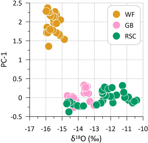
FIGURE 10. Biplot of δ18O and PC-1 for the three water samplers in the La Sal Mountains emphasizing the degree to which water at GB resembles rock glacier water at RSC, and the divergence of non-rock glacier influenced water at WF.
Long-term studies have noted rising values of Ca and Mg in streams fed by rock glaciers and attributed this pattern to melting of buried ice (Caine, 2010). Meltwater derived from this ice may participate in weathering of Ca-bearing minerals in the bedrock (Williams et al., 2006), or be involved in weathering of Ca-bearing eolian dust (Litaor, 2022). Overall degradation of permafrost due to rising ground temperatures has been invoked as a major mechanism behind changing water chemistry in alpine watersheds (Colombo et al., 2018; Liaudat et al., 2020). The results reported here from the La Sal Mountains support this prior work, emphasizing the degree to which the presence of rock glaciers influences the characteristics of water downstream.
5.5 Limitation and directions for future work
The approach employed by this study was successful in generating time series of water samples from springs and streams in the study areas. One limitation in the experimental design, however, is the fact that snowmelt was already underway when the samplers were deployed. This situation is an unavoidable product of the inaccessibility of these locations in the winter, and the fact that the samplers cannot operate in subfreezing temperatures. Nonetheless, future studies employing this methodology should endeavor to deploy samplers as early as possible in the summer to ensure that as much of the snowmelt period is sampled as possible.
The remote location of the samplers also required compositing of samples to stretch the 24-bottle carousel out over as long an interval as possible. The resulting set of 3-day composite samples is sufficient for evaluating long-term trends over the course of the entire melt season, but lacks the resolution necessary to identify shorter-term changes in response to precipitation events (Krainer and Mostler, 2002), or perhaps to accelerated melt driven by particularly warm days (Brighenti et al., 2021a). Samplers capable of collecting a greater number of samples and/or more frequent visits to empty the carousel of 24 bottles would allow a finer-scale sampling interval for identifying more rapid shifts in water chemistry.
A third limitation is that discharge measurements were not collected, therefore it is not possible to identify discharge trends over the course of the melt season or transient changes in association with precipitation events. Water discharge from rock glaciers is notoriously difficult to quantify (Krainer and Mostler, 2002; Krainer et al., 2012) because of the tendency for water to drain below the ground surface through coarse blocks and talus. In the present study, installation of weirs was not approved, so even minimum discharge estimates are, unfortunately, unavailable. Nonetheless, future work could perhaps be focused on alternate locations where temporary weirs might be permitted.
6 Conclusion
Time series of water samples collected from the Uinta and La Sal Mountains in Utah during the summer and fall of 2022 reveal the evolution of rock glacier meltwater composition over the course of the melt season, and the impact of this meltwater on high-elevation stream systems. Rock glaciers discharge water derived from snowmelt in the early summer, but as the snowpack is exhausted, water derived from the melting of internal ice becomes dominant. This later summer water is distinguished by higher values of δ18O, δD, and d-excess, along with elevated electric conductivity and greater abundances of cations including Ca and Mg. The pattern of shifting water sources in 2022 was nearly identical to that noted at the same Uinta Mountain rock glaciers in 2021, indicating that the system behaved in a similar manner for two consecutive melt seasons. Values of EC and hydrochemical parameters are similar for the two Uinta sites and the rock glacier-influenced sites in the La Sal Mountains, but are strikingly different between the two mountain ranges. This discrepancy is attributed to the dominance of quartzite bedrock in the Uintas versus igneous trachyte in the La Sals. Finally, the three sites considered in the La Sals reveal that the hydrochemical characteristics of rock glacier meltwater are transmitted downstream along the main drainage in a watershed containing rock glaciers, establishing notable contrasts in stream water chemistry with a nearby drainage lacking rock glaciers. Collectively, the results of this study underscore the significant role played by rock glaciers in controlling the hydrochemistry of high-elevation watersheds, and provide further motivation to better understand these features as they rapidly adjust to changing climatic conditions in mountain environments.
Data availability statement
The dataset presented in this study can be found in the Hydroshare repository at: www.hydroshare.org/resource/48862df712c1424eb50e54c473630a78.
Author contributions
JM designed the project, conducted the fieldwork and laboratory analyses, interpreted the results, and drafted the figures. JM prepared the manuscript with contributions from AH.
Funding
This work was supported by NSF HS-1935200 to PIs JM and AH, and NSF MRI-1918436 to JM.
Acknowledgments
The authors thank S. Lusk and A. Santis for their assistance in the field, and E. McMahon for help configuring the water samplers. This work was permitted by special-use permit MOA2209 issued by the USDA Manti-La Sal National Forest. Part of this research was carried out at the Jet Propulsion Laboratory, California Institute of Technology, under a contract with the National Aeronautics and Space Administration (80NM0018D0004). The manuscript was improved by the thoughtful comments of C. Del Siro, C. Scapozza, and an reviewer. Fieldwork took place in the ancestral homelands of the Ute tribe.
Conflict of interest
Author ALH was employed by the Jet Propulsion Laboratory.
The remaining author declares that the research was conducted in the absence of any commercial or financial relationships that could be construed as a potential conflict of interest.
Publisher’s note
All claims expressed in this article are solely those of the authors and do not necessarily represent those of their affiliated organizations, or those of the publisher, the editors and the reviewers. Any product that may be evaluated in this article, or claim that may be made by its manufacturer, is not guaranteed or endorsed by the publisher.
References
Anderson, R. S., Anderson, L. S., Armstrong, W. H., Rossi, M. W., and Crump, S. E. (2018). Glaciation of alpine valleys: The glacier–debris-covered glacier–rock glacier continuum. Geomorphology 311, 127–142. doi:10.1016/j.geomorph.2018.03.015
Azócar, G. F., and Brenning, A. (2010). Hydrological and geomorphological significance of rock glaciers in the dry Andes, Chile (27–33 S). Permafr. Periglac. Process. 21, 42–53. doi:10.1002/ppp.669
Berger, J., Krainer, K., and Mostler, W. (2004). Dynamics of an active rock glacier (Ötztal Alps, Austria). Quat. Res. 62, 233–242. doi:10.1016/j.yqres.2004.07.002
Berthling, I. (2011). Beyond confusion: Rock glaciers as cryo-conditioned landforms. Geomorphology 131, 98–106. doi:10.1016/j.geomorph.2011.05.002
Blagbrough, J. W., and Farkas, S. E. (1968). Rock glaciers in the san mateo mountains, south-central new Mexico. Am. J. Sci. 266, 812–823. doi:10.2475/ajs.266.9.812
Brencher, G., Handwerger, A. L., and Munroe, J. S. (2021). InSAR-based characterization of rock glacier movement in the Uinta Mountains, Utah, USA. Cryosphere 15, 4823–4844. doi:10.5194/tc-15-4823-2021
Brighenti, S., Engel, M., Tolotti, M., Bruno, M. C., Wharton, G., Comiti, F., et al. (2021a). Contrasting physical and chemical conditions of two rock glacier springs. Hydrol. Process. 35, e14159. doi:10.1002/hyp.14159
Brighenti, S., Hotaling, S., Finn, D. S., Fountain, A. G., Hayashi, M., Herbst, D., et al. (2021b). Rock glaciers and related cold rocky landforms: Overlooked climate refugia for mountain biodiversity. Glob. Change Biol. 27, 1504–1517. doi:10.1111/gcb.15510
Caine, N. (2010). Recent hydrologic change in a Colorado alpine basin: An indicator of permafrost thaw? Ann. Glaciol. 51, 130–134. doi:10.3189/172756411795932074
Clow, D. W., Schrott, L., Webb, R., Campbell, D. H., Torizzo, A., and Dornblaser, M. (2003). Ground water occurrence and contributions to streamflow in an alpine catchment, Colorado Front Range. Groundwater 41, 937–950. doi:10.1111/j.1745-6584.2003.tb02436.x
Colombo, N., Salerno, F., Gruber, S., Freppaz, M., Williams, M., Fratianni, S., et al. (2018). Review: Impacts of permafrost degradation on inorganic chemistry of surface fresh water. Glob. Planet. Change 162, 69–83. doi:10.1016/j.gloplacha.2017.11.017
Craig, H. (1961). Isotopic variations in meteoric waters. Science 133, 1702–1703. doi:10.1126/science.133.3465.1702
Dansgaard, W. (1964). Stable isotopes in precipitation. Tellus 16, 436–468. doi:10.1111/j.2153-3490.1964.tb00181.x
Fegel, T. S., Baron, J. S., Fountain, A. G., Johnson, G. F., and Hall, E. K. (2016). The differing biogeochemical and microbial signatures of glaciers and rock glaciers. J. Geophys. Res. Biogeosci. 121, 919–932. doi:10.1002/2015jg003236
Geiger, S. T., Daniels, J. M., Miller, S. N., and Nicholas, J. W. (2014). Influence of rock glaciers on stream hydrology in the La Sal Mountains, Utah. Arct. Antarct. Alp. Res. 46, 645–658. doi:10.1657/1938-4246-46.3.645
Giardino, J. R., and Vitek, J. D. (1988). The significance of rock glaciers in the glacial-periglacial landscape continuum. J. Quat. Sci. 3, 97–103. doi:10.1002/jqs.3390030111
Giardino, J. R., Vitek, J. D., and DeMorett, J. L. (1992). “A model of water movement in rock glaciers and associated water characteristics,” in Periglacial geomorphology (Chichester: Wiley), 159–184.
Gröning, M., Lutz, H. O., Roller-Lutz, Z., Kralik, M., Gourcy, L., and Pöltenstein, L. (2012). A simple rain collector preventing water re-evaporation dedicated for δ18O and δ2H analysis of cumulative precipitation samples. J. Hydrol. 448, 195–200. doi:10.1016/j.jhydrol.2012.04.041
Harrington, J. S., Mozil, A., Hayashi, M., and Bentley, L. R. (2018). Groundwater flow and storage processes in an inactive rock glacier. Hydrol. Process. 32, 3070–3088. doi:10.1002/hyp.13248
Hunt, C. B., and Waters, A. C. (1958). Structural and igneous geology of the La sal mountains. Utah: US Government Printing Office.
Ilyashuk, B. P., Ilyashuk, E. A., Psenner, R., Tessadri, R., and Koinig, K. A. (2014). Rock glacier outflows may adversely affect lakes: Lessons from the past and present of two neighboring water bodies in a crystalline-rock watershed. Environ. Sci. Technol. 48, 6192–6200. doi:10.1021/es500180c
Ilyashuk, B. P., Ilyashuk, E. A., Psenner, R., Tessadri, R., and Koinig, K. A. (2018). Rock glaciers in crystalline catchments: Hidden permafrost-related threats to alpine headwater lakes. Glob. change Biol. 24, 1548–1562. doi:10.1111/gcb.13985
Janke, J. R., Ng, S., and Bellisario, A. (2017). An inventory and estimate of water stored in firn fields, glaciers, debris-covered glaciers, and rock glaciers in the Aconcagua River Basin, Chile. Geomorphology 296, 142–152. doi:10.1016/j.geomorph.2017.09.002
Johnson, G., Chang, H., and Fountain, A. (2021). Active rock glaciers of the contiguous United States: Geographic information system inventory and spatial distribution patterns. Earth Syst. Sci. Data 13, 3979–3994. doi:10.5194/essd-13-3979-2021
Jones, D. B., Harrison, S., Anderson, K., Selley, H. L., Wood, J. L., and Betts, R. A. (2018). The distribution and hydrological significance of rock glaciers in the Nepalese Himalaya. Glob. Planet. Change 160, 123–142. doi:10.1016/j.gloplacha.2017.11.005
Jones, D. B., Harrison, S., Anderson, K., and Whalley, W. B. (2019). Rock glaciers and mountain hydrology: A review. Earth-Science Rev. 193, 66–90. doi:10.1016/j.earscirev.2019.04.001
Kääb, A., and Weber, M. (2004). Development of transverse ridges on rock glaciers: Field measurements and laboratory experiments. Permafr. Periglac. Process. 15, 379–391. doi:10.1002/ppp.506
Kluetmeier, C., Handwerger, A., and Munroe, J. (2022). InSAR-based characterization of rock glacier kinematics in the La Sal Mountains. Utah, USA: Copernicus Meetings.
Konrad, S. K., Humphrey, N. F., Steig, E. J., Clark, D. H., Potter, N., and Pfeffer, W. T. (1999). Rock glacier dynamics and paleoclimatic implications. Geology 27, 1131–1134. doi:10.1130/0091-7613(1999)027<1131:rgdapi>2.3.co;2
Krainer, K., and Mostler, W. (2002). Hydrology of active rock glaciers: Examples from the Austrian alps. Arct. Antarct. Alp. Res. 34, 142–149. doi:10.1080/15230430.2002.12003478
Krainer, K., Mostler, W., and Spötl, C. (2007). Discharge from active erock glaciers, Austria alps: A stable isotope approach. Austrian J. Earth Sci. 100, 102–112.
Krainer, K., Mussner, L., Behm, M., and Hausmann, H. (2012). Multi-disciplinary investigation of an active rock glacier in the sella Group (dolomites; northern Italy). Austrian J. Earth Sci. 105, 48–62.
Liaudat, D. T., Sileo, N., and Dapeña, C. (2020). Periglacial water paths within a rock glacier-dominated catchment in the Stepanek area, Central Andes, Mendoza, Argentina. Permafr. Periglac. Process. 31, 311–323. doi:10.1002/ppp.2044
Litaor, M. I. (2022). Alpine ecosystem response to climate warming: Long-term monitoring data of stream chemistries revisited. Sci. Total Environ. 839, 156292. doi:10.1016/j.scitotenv.2022.156292
Millar, C. I., Westfall, R. D., Evenden, A., Holmquist, J. G., Schmidt-Gengenbach, J., Franklin, R. S., et al. (2015). Potential climatic refugia in semi-arid, temperate mountains: Plant and arthropod assemblages associated with rock glaciers, talus slopes, and their forefield wetlands, Sierra Nevada, California, USA. Quat. Int. 387, 106–121. doi:10.1016/j.quaint.2013.11.003
Munroe, J. S., and Handwerger, A. L. (2022). Contribution of rock glacier discharge to late-summer and fall streamflow in the Uinta mountains, Utah, USA. Hydrol. Earth Syst. Sci. Discuss. 27, 1–25. doi:10.5194/hess-27-543-2023
Munroe, J. S., and Laabs, B. J. (2017). Combining radiocarbon and cosmogenic ages to constrain the timing of the last glacial-interglacial transition in the Uinta Mountains, Utah, USA. Geology 45, 171–174. doi:10.1130/g38156.1
Munroe, J. S., and Mickelson, D. M. (2002). Last Glacial Maximum equilibrium-line altitudes and paleoclimate, northern Uinta Mountains, Utah, U.S.A. J. Glaciol. 48, 257–266. doi:10.3189/172756502781831331
Munroe, J. S. (2006). Investigating the spatial distribution of summit flats in the Uinta Mountains of northeastern Utah, USA. Geomorphology 75, 437–449. doi:10.1016/j.geomorph.2005.07.030
Munroe, J. S. (2014). Properties of modern dust accumulating in the Uinta Mountains, Utah, USA, and implications for the regional dust system of the Rocky Mountains. Earth Surf.Process.Landforms 39, 1979–1988. doi:10.1002/esp.3608
Munroe, J. S. (2018). Distribution, evidence for internal ice, and possible hydrologic significance of rock glaciers in the Uinta Mountains, Utah, USA. Quat. Res. 90, 50–65. doi:10.1017/qua.2018.24
Munroe, J. S. (2022). Relation between regional drought and mountain dust deposition revealed by a 10-year record from an alpine critical zone. Sci. Total Environ. 844, 156999. doi:10.1016/j.scitotenv.2022.156999
Nicholas, J. W., and Butler, D. R. (1996). Application of relative-age dating techniques on rock glaciers of the La Sal Mountains, Utah: An interpretation of Holocene paleoclimates. Geogr. Ann. Ser. A. Phys. Geogr. 78A, 1–18. doi:10.1080/04353676.1996.11880448
Nicholas, J. W., and Garcia, J. E. (1997). Origin of fossil rock glaciers, La Sal Mountains, Utah. Phys. Geogr. 18, 160–175. doi:10.1080/02723646.1997.10642614
Nicholas, J. W. (1994). Fabric analysis of rock glacier debris mantles, La Sal Mountains, Utah. Permafr. Periglac. Process. 5, 53–66. doi:10.1002/ppp.3430050106
Obu, J., Westermann, S., Bartsch, A., Berdnikov, N., Christiansen, H. H., Dashtseren, A., et al. (2019). Northern Hemisphere permafrost map based on TTOP modelling for 2000–2016 at 1 km2 scale. Earth-Science Rev. 193, 299–316. doi:10.1016/j.earscirev.2019.04.023
Potter, N. (1972). Ice-cored rock glacier, Galena Creek, northern Absaroka Mountains, Wyoming. Geol. Soc. Am. Bull. 83, 3025–3058. doi:10.1130/0016-7606(1972)83[3025:irggcn]2.0.co;2
PRISM Climate Group (2023). PRISM Climate Data. Available at: https://prism.oregonstate.edu/[Accessed June 16, 2020].
Rangecroft, S., Harrison, S., and Anderson, K. (2015). Rock Glaciers as Water Stores in the Bolivian Andes: An Assessment of Their Hydrological Importance. Arct. Antarct. Alp. Res. 47, 89–98. doi:10.1657/AAAR0014-029
Richmond, G. M. (1962). Quaternary stratigraphy of the La sal mountains, Utah. US Geological Survey, Professional Paper 324, 1–135.
Ross, M. L., Friedman, J. D., and Huffman, A. C. (1998). “Geology of the Tertiary intrusive centers of the La Sal Mountains, Utah—Influence of preexisting structural features on emplacement and morphology,” in Laccolith Complexes of Southeastern Utah: Tectonic Control and Time of Emplacement—Workshop Proceedings: US Geological Survey Bulletin, 61–83.
Sileo, N. R., Dapeña, C., and Trombotto Liaudat, D. (2020). Isotopic composition and hydrogeochemistry of a periglacial Andean catchment and its relevance in the knowledge of water resources in mountainous areas. Isotopes Environ. Health Stud. 56, 480–494. doi:10.1080/10256016.2020.1814278
Steig, E. J., Fitzpatrick, J. J., Potter, N., and Clark, D. H. (1998). The geochemical record in rock glaciers. Geogr. Ann. Ser. A, Phys. Geogr. 80, 277–286. doi:10.1111/j.0435-3676.1998.00043.x
Thies, H., Nickus, U., Tessadri, R., Tropper, P., and Krainer, K. (2017). Peculiar arsenic, copper, nickel, uranium, and yttrium-rich stone coatings in a high mountain stream in the Austrian Alps. Austrian J. Earth Sci. 110. doi:10.17738/ajes.2017.0012
von Freyberg, J., Knapp, J. L. A., Rücker, A., Studer, B., and Kirchner, J. W. (2020). Technical note: Evaluation of a low-cost evaporation protection method for portable water samplers. Hydrology Earth Syst. Sci. 24, 5821–5834. doi:10.5194/hess-24-5821-2020
Wagner, T., Brodacz, A., Krainer, K., and Winkler, G. (2020). Active rock glaciers as shallow groundwater reservoirs, Austrian Alps. Grundwasser 25, 215–230. doi:10.1007/s00767-020-00455-x
Wahrhaftig, C., and Cox, A. (1959). Rock glaciers in the Alaska Range. Geol. Soc. Am. Bull. 70, 383–436. doi:10.1130/0016-7606(1959)70[383:rgitar]2.0.co;2
Williams, M. W., Knauf, M., Caine, N., Liu, F., and Verplanck, P. L. (2006). Geochemistry and source waters of rock glacier outflow, Colorado Front Range. Permafr. Periglac. Process. 17, 13–33. doi:10.1002/ppp.535
Winkler, G., Wagner, T., Pauritsch, M., Birk, S., Kellerer-Pirklbauer, A., Benischke, R., et al. (2016). Identification and assessment of groundwater flow and storage components of the relict Schöneben Rock Glacier, Niedere Tauern Range, Eastern Alps (Austria). Hydrogeology J. 24, 937–953. doi:10.1007/s10040-015-1348-9
Keywords: rock glacier, hydrology, permafrost, mountain environments, stable isotopes
Citation: Munroe JS and Handwerger AL (2023) Examining the variability of rock glacier meltwater in space and time in high-elevation environments of Utah, United States. Front. Earth Sci. 11:1129314. doi: 10.3389/feart.2023.1129314
Received: 21 December 2022; Accepted: 27 March 2023;
Published: 12 April 2023.
Edited by:
Nicola Colombo, National Research Council (CNR), ItalyReviewed by:
Noelia Romina Sileo, CONICET Mendoza, ArgentinaCristian Scapozza, University of Applied Sciences and Arts of Southern Switzerland, Switzerland
Chantal Del Siro, University of Applied Sciences and Arts of Southern Switzerland (SUPSI) Mendrisio, Switzerland, in collaboration with reviewer CS
Copyright © 2023 Munroe and Handwerger. This is an open-access article distributed under the terms of the Creative Commons Attribution License (CC BY). The use, distribution or reproduction in other forums is permitted, provided the original author(s) and the copyright owner(s) are credited and that the original publication in this journal is cited, in accordance with accepted academic practice. No use, distribution or reproduction is permitted which does not comply with these terms.
*Correspondence: Jeffrey S. Munroe, jmunroe@middlebury.edu