The Influence of Continental Mixosedimentite Sedimentation on Shale Oil Sweet Spot: A Case Study on the Permian Lucaogou Formation in the Jimsar Sag of the Junggar Basin, NW China
 Chenggang Liang
 Jinfeng Zhang
 - Jiqing Oilfield Operation Zone, Xinjiang Oilfield Company, PetroChina, Karamay, China
Over the years, shale oil has been at the leading edge of oil exploration and also become the hotspot of reserve increases for various oil fields. The Permian Lucaogou Formation in the Jimsar Sag has been less extensively researched in terms of, among others, lithologic interpretation of fine-grained mixosedimentite, identification and classification of sedimentary microfacies, and sweet spot evaluation. The present study identifies the classification of sedimentary microfacies, characteristic distribution of sedimentary reservoir, and spatial configuration distribution of facies-controlled sweet spot body based on core logging, cutting logging, and data while drilling, combined with logging information, experimental analysis data, and production data with respect to formation test and production test and through the lithology identification based on element logging. This study indicated the following: 1) Microfacies of the reservoir body include a shallow lacustrine sand bar, mixing beach, and dolomitic flat. Different microfacies are adapted to different lithologies or lithological associations. 2) The lower sweet spots P2l12−3, P2l12−2, and P2l12−1 evolved into the dolomitic flat from mixing beach from NE to W. Also, the dolomitic flat is mostly developed in the west of the work area, and the mixing beach is better developed in the east. The shallow lacustrine sand bar is highly developed in the middle location, and the mixing beach and shallow lacustrine sand bar are highly developed on the northern and southern sides. 3) Sedimentary microfacies have evident controls over sweet spots. The upper sweet spots P2l22−3 and P2l22−2 are dominated by Class I sweet spots followed by Class II and IV sweet spots, which are major sweet spot reservoirs. The upper sweet spot P2l22−1 is mainly suffused with Class IV sweet spots, and the Class I reservoir is feldspathic litharenite (shallow lacustrine sand bar microfacies accordingly).
Introduction
Continental shale oil resources are important fossil energy, but their evaluation method and key parameters are still being explored (Yang and Zho, 2019; Hu et al., 2020; Jin et al., 2021). A recent exploration reveals that shale oil reservoirs are mainly found in the Songliao Basin, Bohai Bay Basin, Ordos Basin, and Junggar Basin, and the control reservoirs of them are 54.6 × 10⁸ t, 27.4 × 10⁸ t, 60.5 × 10⁸ t, and 25.1 × 10⁸ t, respectively. These are subsequently the focus of the exploration and development of continental shale oil in China. In particular, fine-grained mixosedimentite in the Permian Lucaogou Formation in the Jimsar Sag of the Junggar Basin is typically representative (Yin et al., 2021).
Since 2011, concerns have been increasingly raised about the exploration and development of tight oil (Guoxin Li et al., 2020; Zhang et al., 2021). The Lucaogou Formation in the Jimsar Sag of the Junggar Basin is the priority to explore and develop tight oil in the Jimsar Sag (Kuang et al., 2015; Wang 2021; Zhi et al., 2019). Recent explorations have achieved remarkable effects and made important breakthroughs; specifically, multiple wells have been successful in finding industrial oil outputs. However, the studies on sedimentary facies in the Lucaogou Formation in the Jimsar Sag to date remain disputable (Shao et al., 2015). The Lucaogou Formation may fall into shore shallow lacustrine facies and deep-semideep lacustrine facies in some scholars’ opinions (Li et al., 2020), while some scholars consider it a deep–shallow lacustrine facies (Ma et al., 2017), and possibly the combination of delta facies, deep lacustrine facies and volcanic facies by others (Zhang 2017). Due to limited data, sedimentary facies in the research area have been less studied to date, especially for microfacies and their sedimentary characteristics. Furthermore, the research on evolution laws is less comprehensive, and distribution characteristics of sedimentary facies need to be further clarified.
This study aims to identify the sedimentary characteristics and sedimentary environment of sweet spot sediments in the Lucaogou Formation of the Jimsar Sag and to definitely understand the changes of sedimentary facies in space and time and even the relationship between sedimentary facies and oil gas. It is necessary to study sedimentary facies in the research area, especially sedimentary microfacies. The influence of sedimentary microfacies on sweet spots is investigated by collecting and analyzing data to understand the paleogeographic environment and regional structure of sweet spots in the Lucaogou Formation in the Jimsar Sag. This is important to developing shale oil on the site and is significant to the theory of fine-grained sedimentology.
Geological Setting
Located in the southeastern edge of the East Junggar Basin, the Jimsar Sag is a half-graben depression that is higher in the east and lowers in the west (Figure 1), the east to Qitai Uplift, the south to Santai Fault Zone, the west to Western Fault Zone, the north to Jimsar Fault Zone, with the area of tectonic unit being approximately 1,278 km2. The sag covers Carboniferous, Permian, Triassic, Jurassic, Cretaceous, Paleogene, Neogene, and Quaternary from bottom to top. Of those, Permian is divided into 3 formations from bottom to top, including the Jingjingzigou Formation, Lucaogou Formation, and Wutonggou Formation. The Lucaogou Formation is one of the pivotal oil-bearing reservoirs in the east of the Junggar Basin. The Lucaogou Formation is fully sagged to be thick in the west and thin in the east, as well as thick in the south and thin in the north, with the average thickness of about 200–350 m, featuring source-reservoir proximity and near-source box-type reservoir mode. The Lucaogou Formation is divided into the second member of the Lucaogou Formation (P2l2) and the first member of the Lucaogou Formation (P2l1) from top to bottom, between which the reservoir-cap assemblage is the sand shale normal cycle assemblage. The second member and first member are divided into 2 formations that develop the upper and lower “sweet spot bodies”. The upper “sweet spot body” is located in P2l22 sand formation of the second member and its lithology is dominated by gray-black dolomitic sandstone, dolerite, and gray feldspar lithic siltstone mixed with black-gray mudstone and dolomitic mudstone. It is mainly distributed on the east slope of sag with the thickness of 13.4–43.0 m and an average of 33 m, and the second member of Lucaogou as a whole is substantially saline lacustrine carbonate sedimentation; the lower “sweet spot body” is located in P2l12 sand formation of the first member and its lithology is principally earth yellow fine siltstone and gray-black (including) dolomitic siltstone mixed with argillaceous siltstone interbedded with black gray mudstone, gray-black (including) dolomitic siltstone or gray-black mudstone. It has fully sagged with a thickness of 17.5–67.5 m and an average of 42.8 m. P2l12 sand formation in the first member of the Lucaogou Formation as a whole represents delta-front facies and shallow lacustrine-semideep lacustrine subfacies sedimentation.
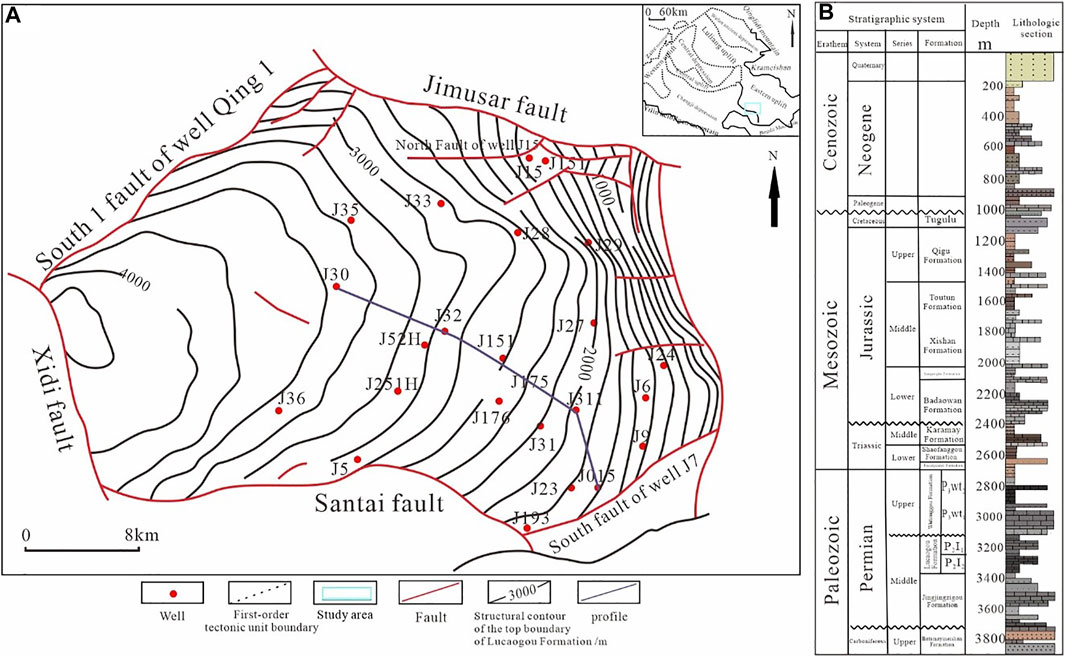
FIGURE 1. Schematic diagram of the work area location. Geological structure map of Jimusar depression (A). Lithologic Histogram of Jimusar Depression (B).
Data and Method
The 34 wells and 524 samples were collected by Xinjiang Oilfield Company. A total of 810 m of cores of the Lucaogou Formation from 34 wells in the Jimusar Sag were logged for the purpose of evaluating the source rocks and depositional characteristics. Combining the research results on the site, the comprehensive analysis of logging information, the analysis and laboratory data with respect to core observations, seismic logging characteristics, formation test, and production test, and through the comprehensive analysis method, we systematically analyzed the sedimentary facies types, dessert types, and their distribution characteristics of the Lucaogou Formation.
Sedimentary facies markers play pivotal roles in the research on sedimentary facies. Different colors of rocks are used to identify the oxidation–reduction property of the sedimentary environment, different rock types and differences in special minerals separately signify different sedimentary environments. Beyond that, the sedimentary sequence and sedimentary tectonics, etc. can also be used to determine the sedimentary environments (Zhang et al., 2013; Zhang et al., 2016; Liu, 2016). In addition, the paleontological characteristics and different morphological characteristics of logging curves are also conductive to the comprehensive research of sedimentary facies.
Color, as the most intuitive marker for core observation, is classified into original color and secondary color by the genesis. Original color is important to identify the sedimentary environment (Schnurrenberger et al., 2003; Matthiessen et al., 2010). An example is applying the color of mudstone to determine the depth of lacustrine basin water and sedimentary environment. In the work area, some colors of core tend to be transitional gradients, but some change drastically. Different colors imply different environments. Generally, it is acknowledged that red mudstone implies oxidation erosion that represents an oxidation environment, while gray, grayish-green and gray-black mudstone show that subaqueous deposit occurs in this period, which is a reduction-specific environment.
Typical wells in sweet spots of the Lucaogou Formation in the Jimsar Sag were made a core observation, indicating that the core of the upper sweet spot in the Lucaogou Formation is mainly black-gray, dark-gray, and gray. This means that the upper sweet spot in the Lucaogou Formation is the subaqueous deposit that occurs in a strong reduction environment. Red mudstone is rarely seen, which signifies the oxidation environment.
Result
Type of Mineral Components and Their Characteristics
From different reservoirs in the work area, 300 core samples were collected for the XRD mineral identification experiment to analyze the content of mineral components. The results show that: The upper sweet spot of the Lucaogou Formation has a variety of mineral components (Kuang et al., 2013; Xia et al., 2013) that are classified into terrigenous clastic minerals and carbonate minerals, including, among others, plagioclase, K-feldspar, quartz, clay minerals, dolomite, calcite, and pyrite. Their attitude and sources of genesis are complicated and varied (Zhang, 2000; Kuang et al., 2012; Xi et al., 2015; Shuqin Li et al., 2020). Feldspar having the maximum content comprises K-feldspar and plagioclase. Plagioclase has a higher content that is up to 58.1% and averages 26%, while K-feldspar has a lower content that is 0.5% to the lowest extent and averages 6.7%. Carbonate minerals consist of dolomite and calcite. Looking at the content, dolomite is far higher than calcite, with approximately twice the calcite content. Dolomite drastically changes in the content from 0.5% to 60%, with an average of 21%, only next to the content of feldspar. The content of feldspar is relatively lower within the range of 0–19%, averaging 11%. It can be seen that the content of feldspar is higher than that of quartz; the Lucaogou Formation has a higher degree of salinization during the development period, calcite is strongly dolomitized and carbonatite sediment is mostly dolomite (Fang et al., 2017; Qu, 2017; Qu et al., 2017; Ma et al., 2018; Zhang et al., 2019; Wang, 2020).
Type of Rocks and Their Characteristics
According to core observations and well logging and other information, the upper sweet spot of the Lucaogou Formation is identified in six basic rock types: mudstone, feldspar lithic fine sandstone, fine siltstone, dolomite sandstone, sandy dolomite, and dolomicrite (Figure 2).
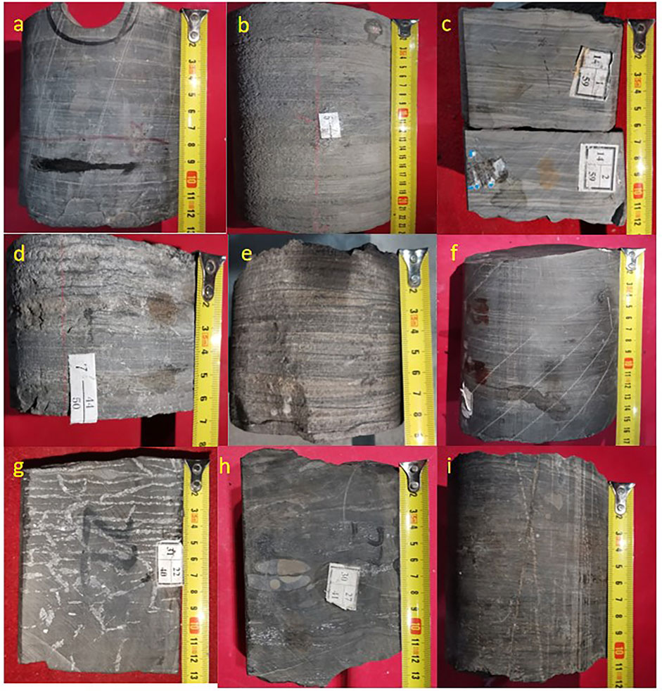
FIGURE 2. Core of Six Types of Rocks in the Lucaogou Formation of the Jimsar Sag. (A) 33/38 1st Barrel No. J251 Well, dark grey calcareous mudstone; (B) 26/50 5th Barrel No. J10024 Well, dark grey argillaceous dolomite; (C) 1, 2/59 14th Barrel No. J10025 Well, light grey argillaceous dolomite; (D) 44/50 7th Barrel No. J10024 Well, dark grey marlite; (E) 58/70 1st Barrel No. J32 Well, light grey dolomitic siltstone; (F) 15/35 5th Barrel No. J305 Well, grey black dolomite mudstone; (G) 22/40 31st Barrel No. J10025 Well, grey black argillaceous siltstone; (H) 27/41 30th Barrel No. J10025, dark grey calcareous siltstone; (I). 63/74 5th Barrel No. J251 Well, dark grey silty mudstone.
Mudstone is widely and stably distributed across the work area with a large thickness, which is mainly developed in P2l22−3 and P2l22−4 small reservoirs, mostly in dark-gray and partially in gray-black. When the thickness increases, they are mostly in gray-black, and black, indicating that they are formed in a water environment with extremely weak hydrodynamic force and often semideep lacustrine facies. when the thickness is average, they are mostly in dark-gray and gray, indicating that they are formed in a weak or oscillating water environment and generally mixing shallow lacustrine facies and clastic shallow lacustrine facies.
Feldspar lithic sandstone is widely identified in P2l22−2 reservoir of the upper sweet spot and is also stably distributed across the work area, which is the major reservoir of the upper sweet spot with good physical properties and lithology specific to the major reservoir. They have also developed in P2l22−1 and P2l22−3 reservoirs, reflecting the process in which water becomes shallow.
Fine siltstone is widely developed in P2l22−2 reservoirs, relatively developed in P2l22−4 reservoir, and locally developed in P2l22−1. Its grain size is 0.01–0.1 mm, and its medium and semi-rounded shapes are screened. They are mostly argillaceous cement, and holes and horizontal fractures are occasionally seen, reflecting a shallow-water sedimentary environment. They generally have the shallow lacustrine sand bar facies and lithology of non-major reservoirs.
Dolomite sandstone as a transitional rock is mainly developed in P2l22−4 reservoir and also in P2l22−3 reservoir with good physical properties, representing a shallow and quiet water environment. They are mostly thin and interbedded with sandy dolomite and generally form a mixing beach in the shallow lake, showing better reservoir lithology.
Sandy dolomite has a high porosity and is mainly identified in P2l22−1, P2l22−3, and P2l22−4 reservoirs, mostly mixed with dolomicrite and frequently interbedded with dolomitic siltstone. They are mostly dolomitic flats and mixing beaches, representing a shallow-water sedimentary environment with good reservoir lithology.
Dolomicrite is mostly in dark-gray and gray with a small thickness. They mainly grow in P2l22−1 and P2l22−3 reservoirs and relatively in P2l22−4 reservoir, reflecting a shallow-water sedimentary environment with bad physical properties, which is not good reservoir lithology.
Type of Sedimentary Facies and Their Characteristics
The studies on the sedimentology of the Lucaogou Formation in the Jimsar Sag to date remain disputable. The Lucaogou Formation may fall into shore shallow lacustrine facies and deep–semideep lacustrine facies in some scholars’ opinions (Li et al., 2020), while some scholars consider it is a deep–shallow lacustrine facies (Ma et al., 2017), and possibly the combination of delta facies, deep lacustrine facies and volcanic facies by others (Zhang et al., 2013). Due to limited data, sedimentary facies in the research area have been less studied to date, especially for microfacies and their sedimentary characteristics. Further, the research on evolution laws is less comprehensive, and the distribution characteristics of sedimentary facies also need to be further clarified.
According to the detailed observations made on the core of key wells across the work area, based on sedimentary facies markers and combined with good logging and others, the Lucaogou Formation is divided into two sedimentary facies: lacustrine facies and delta facies, based on previous studies and considering the regional geological background of the research area. Generally, the focus is on lacustrine facies, and deltaic facies are mainly developed in the lower sweet spot. The Lucaogou Formation is further divided into three subfacies and six microfacies (Table 1). Of those, semideep-deep lacustrine subfacies consist of semideep lacustrine mud microfacies; mixing shallow lacustrine subfacies comprise dolomitic flat, mixing beach and mixing shallow lacustrine mud microfacies; clastic shallow lacustrine subfacies include a shallow lacustrine sand bar and clastic shallow lacustrine mud microfacies.
1) Semideep-deep lacustrine subfacies
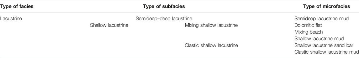
TABLE 1. Classification of sedimentary facies in the Lucaogou Formation of the Jimsar Sag.
Semideep-deep lacustrine subfacies are below the wave base and the water body is relatively deeper. The sedimentary environment is an anoxic weak reduction environment, and the lithology is mainly gray-black and dark-gray mudstone and dolomicrite. The horizontal bedding is developed with scattered and lump pyrite authigenic minerals.
2) Mixing shallow lacustrine subfacies
Mixing shallow lacustrine subfacies are found at a relatively shallow water level. The microfacies are dolomitic flat, mixed with beach and shallow lacustrine mud. The water body of a dolomitic flat has high salinity. When it is proximate to the input area of terrigenous clastic, chemical sedimentation will be formed; when the hydrodynamic force is weaker, dolomicrite. When the hydrodynamic force becomes stronger, the interbedding between sandy dolomite and dolomitic siltstone is formed. Horizontal bedding, liquefied deformation structure, stylolitic structure, bird-eye structure, and calcite vein are developed here.
The mixing beach is the transitional zone between dolomitic flat sedimentation and shallow lacustrine mud sedimentation. At the transitional beach, the water body is shallow and weak in hydrodynamic force. Affected by wave actions, the lithology is light grey dolomitic (calcareous) siltstone. Ripple bedding, calcite vein, and liquefied deformation phenomena are found and locally biological lumachelle seen. The sand body has good continuity and is widely distributed with good selectivity and rounding degree. This is a favorable reservoir in the upper sweet spot.
The lithology of mixing shallow lacustrine mud is mainly gray-black dolomite mudstone and dolomicrite. A shallow water body, weak hydrodynamic force, and high salinity are identified. The horizontal bedding dominated by liquefied deformation and calcite veins.
3) Clastic shallow lacustrine subfacies
Clastic shallow lacustrine subfacies are located in the shallowest water body between the deepest lacustrine level during the drought period and wave base, comprising shallow lacustrine sand bar and clastic shallow lacustrine mud microfacies.
Shallow lacustrine sand bar microfacies reflect a shallow water body, stronger hydrodynamic conditions, and wave actions. The lithology is mainly siltstone interbedded between light gray sandy dolomite and dolomitic siltstone. They are relatively thick and ripple bedding and wave-formed-into-ripple bedding. The grain size is large and the sand body has good continuity together with good selectivity and rounding degree. This is the most favorable reservoir in the upper sweet spot. The lithology of clastic shallow lacustrine mud microfacies is grey mudstone with horizontal bedding. The places with a stronger hydrodynamic force are accompanied by a small cross-bedding and also stylolite and liquefied deformation structures, which are locally fossilized fern leaves.
Analysis of Sedimentary Facies for a Single Well
Based on the analysis of facies markers of the upper sweet spot in the Lucaogou Formation of the Jimsar Sag, 15 important, representative, and typical wells are selected for the schematic diagram of single well sedimentary facies. For example, a detailed analysis of single well sedimentary facies was conducted for the upper sweet spot of one important well that is J10005 well (Figure 3). The well is located in the east-south direction of the research area and is near the source area. From top to bottom there are 3 types of sedimentary subfacies, i.e., clastic shallow lacustrine, mixing shallow lacustrine, and semideep-deep lacustrine mud, of which clastic shallow lacustrine and mixing shallow lacustrine dominate. A thin layer of shallow lacustrine sand bar is observed at the bottom of P2l22−3 reservoirs, mixing shallow lacustrine subfacies are mostly distributed at the upper part of P2l22−3 and the lower part of P2l22−2, and clastic shallow lacustrine subfacies mainly at the upper part of P2l22−2 and P2l22−1 and occasionally found at the bottom of P2l22−3. However, semideep-deep lacustrine subfacies are in the middle of P2l22−2. Various microfacies in the subfacies are fully developed. Specifically, mixing shallow lacustrine corresponds to mixing shallow lacustrine mud microfacies and clastic shallow lacustrine to clastic shallow lacustrine mud microfacies mixed with shallow lacustrine sand bar microfacies which are mainly identified in P2l22−2 reservoirs. Semideep-deep lacustrine adapts to semideep lacustrine mud microfacies that are in the middle of P2l22−2 reservoirs. During the whole P2l22−3 periods, the normal graded bed sequence having the gradually reduced grain size is seen from bottom to top. During the P2l22−2 periods, a lacustrine level first goes up and then drastically goes down, and during the P2l22−1, it begins to rise. Therefore, both normal graded bed sequence and inverse graded bed sequence occur, generally reflecting a lacustrine transgressive-lacustrine regressive process.
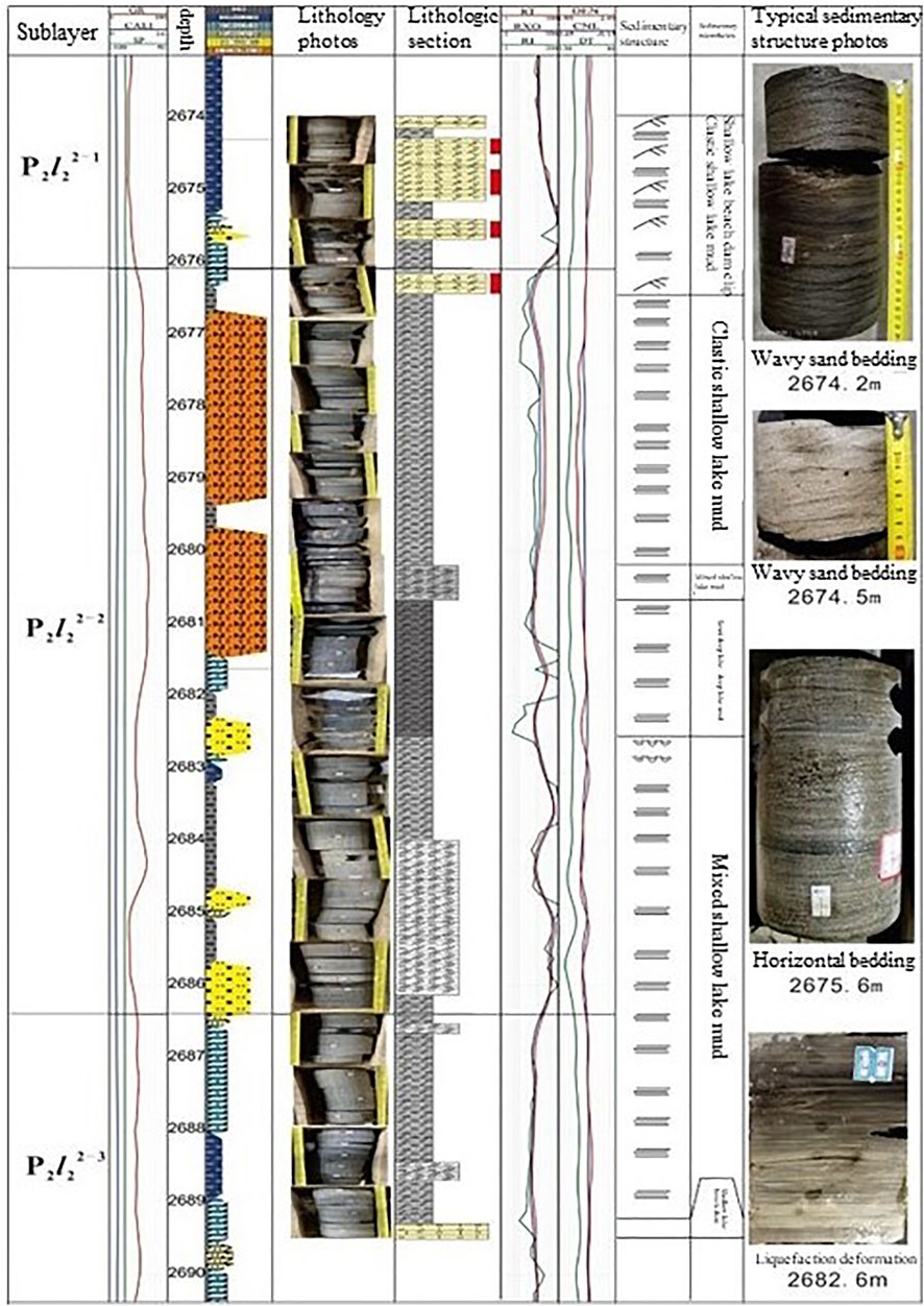
FIGURE 3. Schematic diagram of sedimentary microfacies with respect to the core of upper sweet spot in J10005 Well of the Lucaogou Formation in the Jimsar Sag.
Analysis of Interwell Sedimentary Facies
According to existing information, as there are different sedimentary systems between the upper and lower sweet spots, the interwell comparison was made between the upper and lower sweet spots. This profile is a section along the east-west direction towards the north and perpendicular to the source area direction (Figure 4), comprising six wells from the west to the east: J404, J10039, J10031, J10017, J10014, and J0028. In the interwell profile transverse across the source area direction in the sweet spot member P2l22−2, shallow lacustrine beach bar has good transverse continuity and a relatively uniform thickness, and is distributed from J404 to J10028 along the east-west direction. The sweet spot member P2l22−3 is found between J10039 and J10032 wells, but a single layer is thin and has poor transverse continuity. As the profile is extended to the west, the water body is deepened. The shallow lacustrine sand bar is intensively developed and dolomitic flat is mainly in the west of the work area, but not developed in the east of the work area.
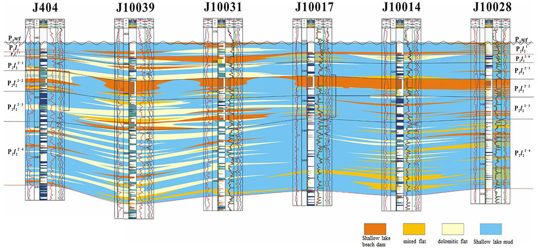
FIGURE 4. Profile facies of J404∼J10039∼J10031∼J32∼J10017∼J10014∼J10028 wells in the upper sweet spots of the Lucaogou Formation in the Jimsar Sag.
This profile is a section along the south–north direction towards the east and parallel to the source area direction (Figure 5), comprising 7 wells from the north to the south: J34, J10017, J10016, J10015, J174, J176, and J31. In the above figure, during the P2l22−4 period, mixing shallow lacustrine sedimentation is mainly developed, including mixing beach sedimentation in the lower part and dolomitic flat sedimentation in the upper part, reflecting the lacustrine level going up. During the P2l22−3 period, dolomitic flat sedimentation dominates, mixed with a small amount of mixing beach sedimentation, which is mostly distributed in a laminar shape. During the P2l22−2 period, as it is close to the source area, the sweet spot member mainly presents shallow lacustrine sand bar microfacies, and the thickness is gradually thinned from the north to the south. However, the development of shallow lacustrine sand bars is average. During the P2l22−1 period, dolomitic flat sedimentation dominates, accompanied by shallow lacustrine sand bar sedimentation. In conclusion, the development of shallow lacustrine sand bar is average. Dolomitic flat is mainly developed in the middle part, i.e., close to J10015 Well, but not interbedded in the north and south (sandy dolomite is not developed). Substantially, the lacustrine level first becomes shallow and then deeper.
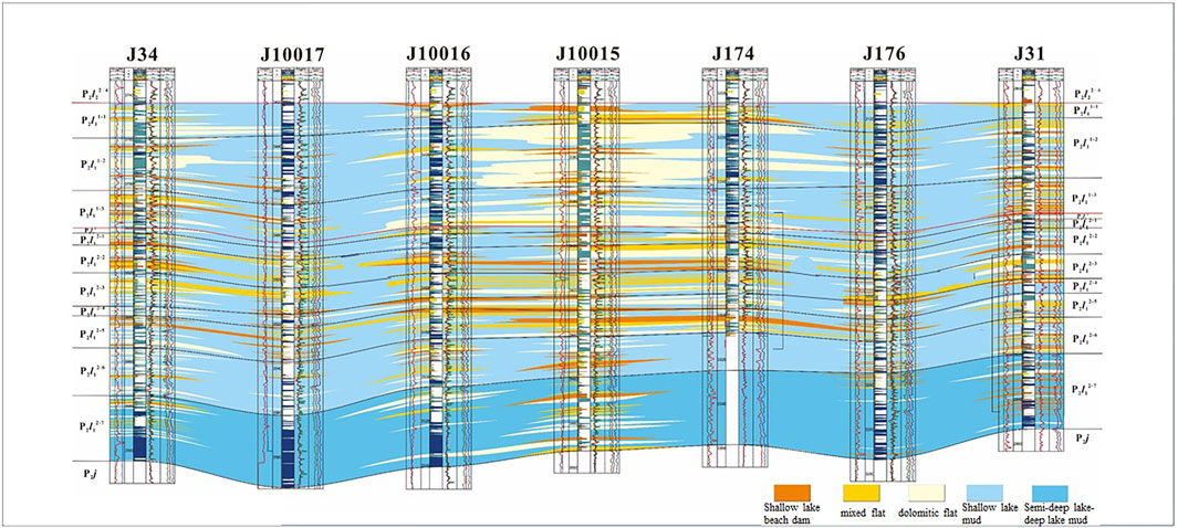
FIGURE 5. Profile facies of J34∼J10017∼J10016∼J10015∼J174∼J76∼J31 wells in the upper sweet spots of the Lucaogou Formation in the Jimsar Sag.
This profile is a section along the east–west direction towards the north and perpendicular to the source area direction (Figure 6), comprising 6 wells from the west to east: J404, J10039, J10031, J10017, J10014, and J0028. This profile indicates dolomitic flat is developed in the west, relatively far from the source area, especially near J10039 Well. The lithology is sandy dolomite accompanied by dolomicrite with a lower thickness and average transverse continuity, which is vertically distributed in each reservoir, especially in P2l11−3, P2l12−1, P2l12−2, and P2l12−3 reservoirs. In the east, the shallow lacustrine sand bar is less developed, and the thickness of a single layer is lower with poor transverse continuity. The prevailing lithology is siltstone that is identified in P2l12−4, P2l12−5, and P2l12−6 reservoirs. As the profile is extended to the west, the water body becomes deep, and sedimentary microfacies are transformed into dolomitic flats from the shallow lacustrine sand bar.
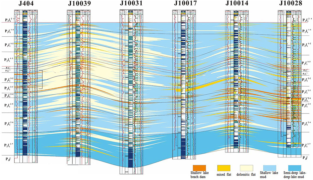
FIGURE 6. Profile facies of J404∼J10039∼J10031∼J32∼J10017∼J10014∼J10028 wells in the lower sweet spots of the Lucaogou Formation in the Jimsar Sag.
This profile is a section along the south–north direction towards the east and parallel to the source area direction (Figure 7), comprising seven wells from the north to the south: J34, J10017, J10016, J10015, J174, J176, and J31. The shallow lacustrine sand bar is better developed in J10015 Well and on the south and north sides. The lithology is siltstone with good transverse continuity. Mixing beach and dolomitic flat are thinly interbedded in other sites. Dolomitic flat is mainly in the upper formation of J10015 Well, and the lithology is sandy dolomite mixed with dolomicrite. Mixing beach prevails in the lower formation of J10015 Well, and the water body as a whole tends to be deeper gradually.
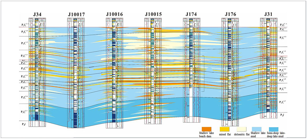
FIGURE 7. Profile facies of J34∼J10017∼J10016∼J10015∼J174∼J76∼J31 wells in the lower sweet spots of the Lucaogou Formation in the Jimsar Sag.
Characteristics of Plane Sedimentary Facies
Based on the clear classification of sediments and through the comparison between single good facies and interwell facies and research on sedimentary microfacies, vertical and horizontal distribution characteristics of different lithologies in different reservoir locations are drawn by using the isoline folding method. The plane distribution diagram can be acquired according to the detailed observations of cores in the Lucaigou Formation of the Jimsar Sag combined with a good position map (Figures 8, 9).
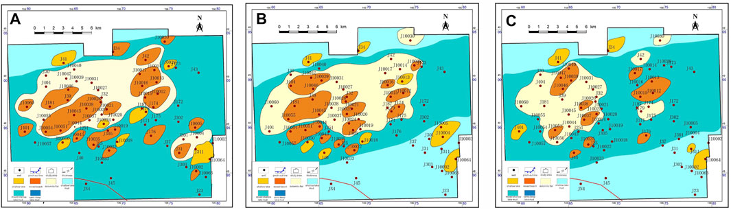
FIGURE 8. Sedimentary microfacies plane distribution in the lower sweet spot of the Lucaogou Formation in the Jimsar Sag. (A) sedimentary microfacies plane of P2l12−3. (B) sedimentary microfacies plane of P2l12−2. (C) sedimentary microfacies plane of P2l12−1.
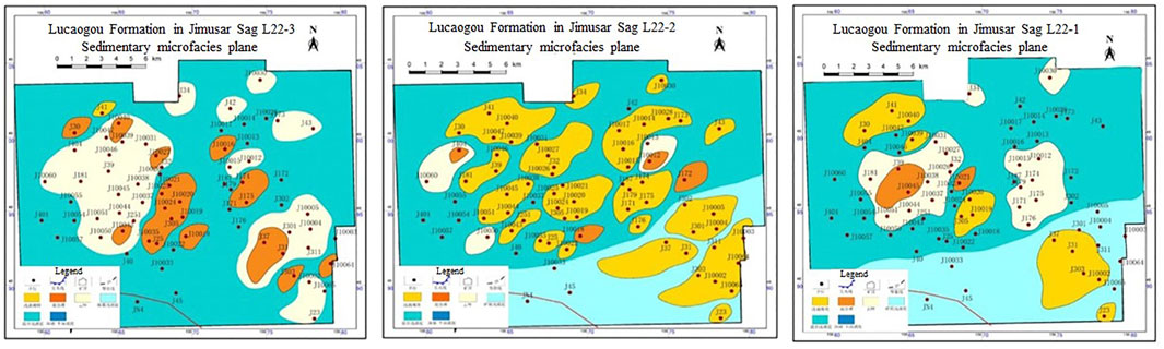
FIGURE 9. Sedimentary microfacies plane distribution in the upper sweet spot of the Lucaogou Formation in the Jimsar Sag. (A) Sedimentary microfacies plane of P2l22−3. (B) Sedimentary microfacies plane of P2l22−2. (C) Sedimentary microfacies plane of P2l22−1.
The following shows the sedimentary facies plane of P2l12−3 small reservoir. The lacustrine level as a whole goes down. On the overall south side is a mixing beach, and on the north side is a clastic shallow lacustrine and developed the dolomitic flat and mixing beach that are widely distributed. Of those, dolomitic flat is identified in the north to west, and mixing beach in the Midwest part. The shallow lacustrine beach bar is also developed and becomes thick-thin-thick from the southeast to the northwest, but its sand body in the north is relatively thicker. It can be seen from the sedimentary facies plane of P2l12−2 small reservoir that the lacustrine level begins to go up. In the middle part is mixing shallow lacustrine and on the south and north sides is clastic shallow lacustrine. Dolomitic flat here is extremely developed and widely extended across the Midwest part. Mixing beach is developed in the Midwest part and narrowed in the range from the west to east, but developed to the largest extent in the west. The shallow lacustrine sand bar is better developed in the southeast part and scattered in the middle and north parts. Looking at the sedimentary facies plane of P2l12−1 small reservoir, the lacustrine level continues to rise during this period. Compared with P2l12−2 small reservoir, the area sums of mixing beach and shallow lacustrine beach bar on the part of mixing shallow lacustrine is greatly reduced. The shallow lacustrine sand bar in the southeast part is narrowed in the distribution range.
During the P2l22−3 period, the lacustrine level rises, and mixing shallow lacustrine is wholly prevailing, widely concurrent with dolomitic flat and mixing beach, the range and thickness of which are significantly increased. The dolomitic flat is mainly distributed in the west and the southeast part of the work area in a broad range. The shallow lacustrine sand bar is only developed in the northern part, for example, near J41 Well. During the P2l22−2 period, the lacustrine level quickly goes down, and a shallow lacustrine sand bar is extensively developed and distributed along the northwest-southeast direction with good transverse continuity and the largest thickness, which is the best reservoir rock in this area. The area of the dolomitic flat and mixing beach is greatly reduced and the thickness is also drastically reduced. The dolomitic flat is well developed near the western J10055-J10060 Wells. During the P2l22−1 period, however, the lacustrine level goes up again, and the north part mostly falls into mixing shallow lacustrine, widely accompanied by dolomitic flat. Mixing beach is better developed in low-altitude places, such as the middle to the west part of the lake basin, mainly distributed in the northwest. As it is less affected by the southern source area, the southern part falls into a clastic shallow lacustrine that is widely developed with a large thickness.
Discussion
Criteria for Classification of Sweet Spots
Due to the particularity of the Lucaogou Formation in the Jimsar Sag, other criteria for reservoir evaluation are not suitable for classifying the reservoirs in this research area (Zou et al., 2013; Bao et al., 2016; Zhao et al., 2020). It is necessary to select representative parameters according to the fact that to establish a set of criteria appropriate to this area to classify and evaluate the reservoirs in this area.
With reference to the movable porosity and oil-bearing saturation interpreted from nuclear magnetic materials in oil field information, the classification and evaluation form of sweet spot reservoirs in the Lucaogou Formation of the research area is prepared on the basis of classification criteria for oil fields and combined with element, lithology, and sedimentary microfacies characteristics (see Table 2).
1) Criteria for classification of upper sweet spots
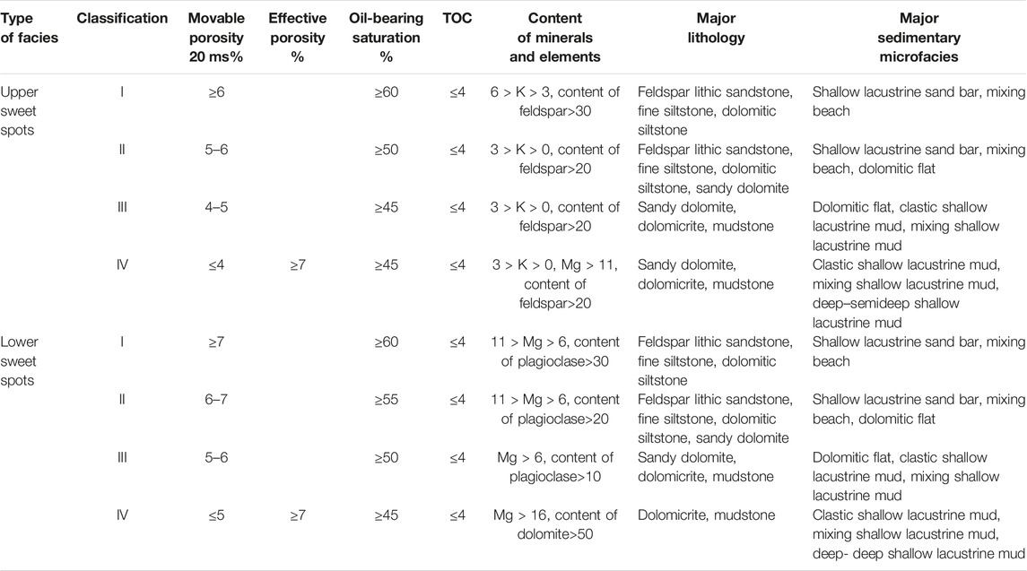
TABLE 2. Criteria for classification of sweet spots in the Lucaogou Formation of the Jismar sag.
Class I sweet spot: this reservoir is mainly developed with shallow lacustrine sand bar microfacies in the clastic shallow lacustrine subfacies, so it is an excellent reservoir in the research area with a large pore permeability and good physical properties. The pore structure is mainly intergranular pore and intergranular corrosion pore. The formation thickness is large, the movable porosity is ≥ 6% and oil-bearing saturation is higher with a value ≥ 60%. It is the right reservoir for a well with good formation testing in the research area.
Class II sweet spot: this reservoir is mainly developed by mixing beach microfacies in the mixing shallow lacustrine subfacies that are widely distributed in the research area. The pore structure is mainly corrosion pore and intergranular corrosion pore. The pore permeability is slightly lower than that of the Class I reservoir. The movable porosity is within the range of 5%–(inclusive)6% (inclusive), oil-bearing saturation is better with a value ≥ 50%. This is a relatively good reservoir in this area.
Class III sweet spot: this reservoir is mainly developed with dolomitic flat microfacies in the mixing shallow lacustrine subfacies, which is a poor type in the research area in terms of comprehensive indicators, but widely distributed in this area. The pore structure is mainly intergranular corrosion pore and intercrystalline porosity. The pore permeability is relatively worse. The movable porosity is within the range of 4–5% (inclusive), oil-bearing saturation is average with a value ≥ 45%. This is an average reservoir in this area.
Class IV sweet spot: this reservoir is mainly developed by mixing shallow lacustrine mud, and semideep lacustrine mud microfacies with the worst pore permeability. Physical properties are the worst; the movable porosity is ≤ 4%, oil-bearing saturation is poor and the effective porosity is >7%. This is the worst reservoir in this area.
2) Criteria for classification of lower sweet spots
Class I sweet spot: this reservoir is mainly developed with shallow lacustrine sand bar microfacies in the clastic shallow lacustrine subfacies, so it is an excellent reservoir in the research area with a large pore permeability and good physical properties. The pore structure is mainly intergranular pore and intergranular corrosion pore. The formation thickness is large, the movable porosity is ≥ 7% and oil-bearing saturation is higher with a value ≥ 60%. It is the right reservoir for a well with good formation testing in the research area.
Class II sweet spot: this reservoir is mainly developed by mixing beach microfacies in the mixing shallow lacustrine subfacies that are widely distributed in the research area. The pore structure is mainly corrosion pore and intergranular corrosion pore. The pore permeability is slightly lower than that of the Class I reservoir. The movable porosity is within the range of 6–7% (inclusive), oil-bearing saturation is better with a value ≥ 55%. This is a relatively good reservoir in this area.
Class III sweet spot: this reservoir is mainly developed with dolomitic flat microfacies in the mixing shallow lacustrine subfacies, which is a poor type in the research area in terms of comprehensive indicators, but widely distributed in this area. The pore structure is mainly intergranular corrosion pore and intercrystalline porosity. The pore permeability is relatively worse. The movable porosity is within the range of 5–6% (inclusive), oil-bearing saturation is average with a value ≥ 50%. This is an average reservoir in this area.
Class IV sweet spot: this reservoir is mainly developed by mixing shallow lacustrine mud, shallow lacustrine mud, and semideep lacustrine mud microfacies with the worst pore permeability. Physical properties are the worst; the movable porosity is ≤ 5%, oil-bearing saturation is poor with a value ≥ 45% and the effective porosity is ≥ 7%. This is the worst reservoir in this area.
Classification Characteristics of Sweet Spots
This research indicates that the major oil-bearing lithologies in this area are feldspar lithic sandstone, dolomitic siltstone, and sandy dolomite (Feng et al., 2015; Song et al., 2017; Liu et al., 2019), but the pore permeability significantly differs between different lithologies under the same classification of sweet spots, especially in Class I and II sweet spots as major development objectives. According to the analysis of experimental data statistics, the pore permeability of dolomitic siltstone is the best, showing the permeability is 0.01–1.0mD with an average of 0.052mD and the porosity is 3%–19% with an average of 11.8%. In Class I sweet spots, however, the porosity of Class I dolomitic siltstone can reach 15.6%, and the permeability is 0.164md, while in Class IV dolomitic siltstone, the porosity is 8.88% and the permeability is 0.052md.
In the meantime, the lithology is subdivided to establish the sweet spot grading chart (Figure 10). The physical properties of dolomitic siltstone are the best as such, especially in Class I and II sweet spots as major development objectives.
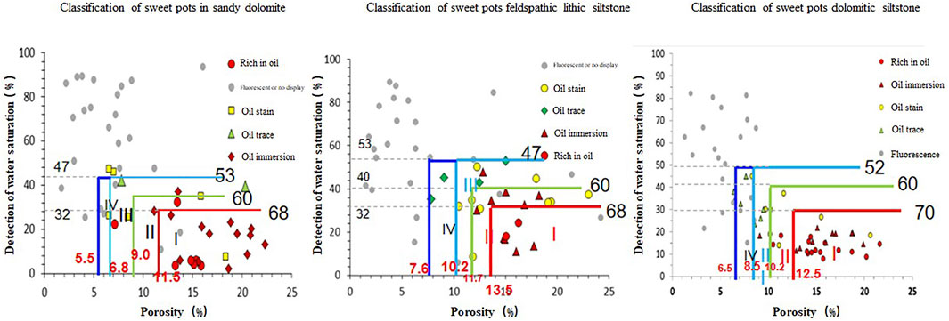
FIGURE 10. Different lithology grading chart of the upper sweet spots in the Lucaogou Formation of the Jimsar Sag.
Parameter Distribution of Facies-Controlled Reservoirs
Sedimentary facies control the distribution of reservoirs in the plan and profile. The plane distribution diagram of NM porosity and NM saturation of major development members is drawn in the upper and lower sweet spots, laying a foundation for the research on plane distribution characteristics of sweet spots to identify the tendency of physical property changes on the plane in the Lucaogou Formation of the Jimsar Sag (Figure 11).
1) Parameter distribution characteristics of facies-controlled reservoirs in the upper sweet spot:
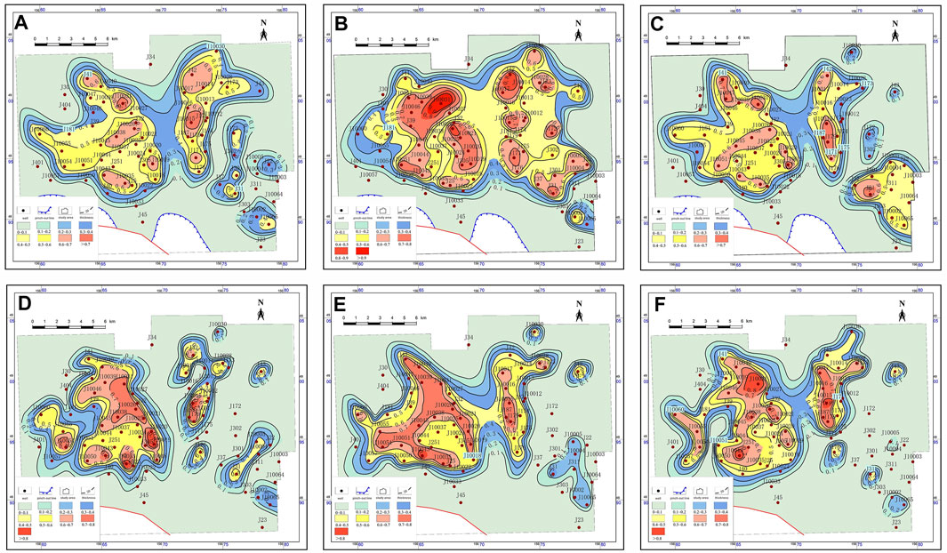
FIGURE 11. NM saturation distribution diagram of sweet spots in the Lucaogou Formation of the Jimsar Sag. (A) NM saturation distribution diagram of sweet spots in P2l22−3. (B) NM saturation distribution diagram of sweet spots in P2l22−2. (C) NM saturation distribution diagram of sweet spots in P2l22−1. (D) NM saturation distribution diagram of sweet spots in P2l12−3. (E) NM saturation distribution diagram of sweet spots in P2l12−2. (F) NM saturation distribution diagram of sweet spots in P2l12−1.
P2l22−1 reservoir: this reservoir is extensively developed with the dolomitic flat in the south and middle part of the work area, and some wells are accompanied by a shallow lacustrine beach bar and mixing beach. The shallow lacustrine beach bar covers a large area in the southwest of the work area and corresponds to the wells with high oil-bearing saturation.
P2l22−2 reservoir: this reservoir is widely developed with a shallow lacustrine beach bar in a flake shape across this area. Few wells in the east and west part of the work area are accompanied by a small area of dolomitic flat and mixing flat. The shallow lacustrine beach bar that is developed in the southwest has good continuity and covers a large area, fit for a high oil-bearing saturation.
P2l22−3 reservoir: this reservoir as a whole fall into mixing shallow lacustrine and is broadly developed with a dolomitic flat across this area. In the middle part of the work area, a massive flake-shaped mixing flat is found, while a small area of mixing flat is identified in other areas with poor continuity. According to the parameter distribution plane of facies-controlled reservoirs, mixing flat is very fit for the well locations with high oil-bearing saturation.
2) Parameter distribution characteristics of facies-controlled reservoirs in the lower sweet spot:
P2l22−1 reservoir: this reservoir is extensively developed with a dolomitic flat in the middle part of the work area, and some wells in the north and south are accompanied by a small area of shallow lacustrine beach bar sediments. A large area of flake-shaped mixing flat sediments is developed in the middle part together with multiple small-scale mixing flat sediments, well fit for a high oil-bearing saturation.
P2l22−2 reservoir: this reservoir is mixing shallow lacustrine in the middle part of the work area and is widely developed with dolomitic flat sediments to a large extent, also accompanied by a large area of mixing flat, which has a good continuity in the plane and mainly distributed in the dolomitic flat development area. A small area of shallow lacustrine beach bar sediment is developed in the south-north part, very fit for a high oil-bearing saturation.
P2l12−3 reservoir: a small area in the north for this reservoir is only located in clastic shallow lacustrine, and nearly the overall area is in mixing hallow lacustrine. In this area, the dolomitic flat is broadly developed, and the middle part of this work area is nearly brimming with dolomitic flat sediments that are covered with a large area of mixing flat with good continuity. Some wells are developed with a small area of shallow lacustrine beach bar sediments, very fit for a high oil-bearing saturation.
Distribution of Facies-Controlled Sweet Spots
Based on the aforesaid research of data, the sweet spot distribution plane diagram is drawn by different reservoirs of the upper and lower sweet spots in the Lucaogou Formation (Figure 12).
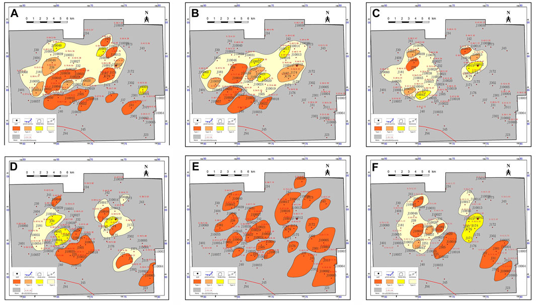
FIGURE 12. Sweet spot plane distribution of the Lucaogou Formation in the Jimsar Sag. (A) Sweet spot plane distribution of P2l12−3. (B) Sweet spot plane distribution of P2l12−2. (C) Sweet spot plane distribution of P2l12−1. (D) Sweet spot plane distribution of P2l22−3. (E) Sweet spot plane distribution of P2l22−2. (F) Sweet spot plane distribution of P2l22−1.
P2l22−1 reservoir: Class I and IV sweet spots of this reservoir are well developed across this area. Class I sweet spots are mainly distributed in the southeast and middle part of the research area in a flake shape with good continuity. They are shallow lacustrine sand bar microfacies that are developed with feldspar lithic sandstone and dolomitic siltstone; Class II sweet spots are mainly distributed in the west in an isolated shape. They are mixing beach microfacies that are developed with dolomitic siltstone and sandy dolomite; Class III sweet spots are widely developed in the east of the work area and distributed in a strip shape, showing a good continuity and large area. They are dolomitic flat microfacies that are developed with sandy dolomite and dolomicrite; Class IV sweet spots are distributed in the west of the research area and extensively developed, but less developed in the east. They are clastic shallow lacustrine mud, mixing shallow lacustrine mud and semideep lacustrine mud microfacies that are developed with dolomicrite and mudstone.
P2l22−2 reservoir: Class I sweet spots of this reservoir are the most developed and extensively distributed across the area, and have good continuity and large area in the southwest part, also with good continuity and extensive development in the east and south. They are shallow lacustrine sand bar microfacies that are developed with feldspar lithic sandstone and dolomitic siltstone.
P2l22−3 reservoir: this reservoir is dominated by Class I and IV sweet spots. Class I sweet spots are extensively distributed in the middle part of the work area and scattered in the southeast and east of the work area in an isolated shape. They are shallow lacustrine sand bar microfacies that are developed with feldspar lithic sandstone and dolomitic siltstone; No Class IV sweet spots are found here; Class III sweet spots are less distributed in the east and west of the work area. They are dolomitic flat microfacies that are covered with sandy dolomite and dolomicrite; Class IV sweet spots widely appear in the middle parts in a flake shape and occasionally in the southeast in a broad flake shape. They are clastic shallow lacustrine mud, mixing shallow lacustrine mud and semideep lacustrine mud microfacies that are covered with dolomicrite and mudstone.
P2l12−1 reservoir: this reservoir is dominated by Class IV sweet spots. Class I sweet spots only appear in J10046 and J10017 wells in the east and west; Class II sweet spots are only distributed in a few wells in the east and west; Likewise, Class III sweet spots are only found in a few wells; However, Class IV sweet spots are extensively distributed in the east and west in a flake shape with good continuity. They are clastic shallow lacustrine mud, mixing shallow lacustrine mud and semideep lacustrine mud microfacies that are covered with dolomicrite and mudstone.
P2l12−2 reservoir: this reservoir is dominated by Class I and IV sweet spots. Class I sweet spots are widely developed in the east of the work area in a flake shape with good continuity. They are shallow lacustrine sand bar microfacies accompanied by feldspar lithic sandstone and dolomitic siltstone and dolomitic siltstone; Class II sweet spots are continuously distributed in the east of the work area with a small area in some wells in the west of work area. They are mixing beach microfacies that are mainly developed with dolomitic siltstone and sandy dolomite; Class III sweet spots are only scattered in the middle part of the work area in an isolated shape; Class IV sweet spots are extensively distributed in a flake shape, which appear in the middle part of the work area.
P2l12−3 reservoir: this reservoir is dominated by Class I and IV sweet spots. Class I sweet spots are developed across the work area and widely distributed in a strip shape with good continuity. They are shallow lacustrine sand bar microfacies that are developed with feldspar lithic sandstone and dolomitic siltstone; Class II sweet spots are only more distributed in the west of the work area in an isolated shape without a continuity. They are mixing beach microfacies that are accompanied by dolomitic siltstone and sandy dolomite; Class III sweet spots only appear in some wells. There are dolomitic flat microfacies that are developed with sandy dolomite and dolomicrite; Class IV sweet spots are distributed like that in P2l12−2 reservoir, which is developed across the work area with good continuity. They are clastic shallow lacustrine mud, mixing shallow lacustrine mud and semideep lacustrine mud microfacies that are covered with dolomicrite and mudstone.
Conclusion
The conclusion of the research on sedimentary facies and reservoir characteristics of sweet spots in the Permian Lucaogou Formation of the Jimsar Sag is given as follows:
1) Upper sweet spots of the Lucaogou Formation are divided into 3 sedimentary subfacies and 6 sedimentary microfacies. Of those, semideep-deep lacustrine subfacies are divided into semideep lacustrine mud microfacies; Mixing shallow lacustrine subfacies are classified into dolomitic flat, mixing beach, and mixing shallow lacustrine mud microfacies; clastic shallow lacustrine can be further divided into a shallow lacustrine sand bar and clastic shallow lacustrine mud sedimentary microfacies;
2) The south and north sides of lower sweet spots are developed with a mixing beach and shallow lacustrine sand bar, which are transformed into the dolomitic flat from a mixing beach from the east to the west. Dolomitic flat of the lower sweet spots mainly occurs in the west, the shallow lacustrine sand bar is highly developed in the middle parts, and the mixing beach appears in the east;
3) Reservoirs of the upper sweet spots in the Lucaogou Formation of the Jimsar Sag comprise 4 types of sweet spots. It is acknowledged that Class I and II sweet spots are shallow lacustrine sand bar, mixing beach, and dolomitic flat microfacies, which are mainly distributed in P2l22−2 reservoir. Class III sweet spots are dolomitic flat microfacies, clastic shallow lacustrine mud, and mixing shallow lacustrine mud microfacies, which are distributed in P2l22−1, P2l22−2, and P2l22−3 reservoirs and locally distributed in P2l22−4 reservoir; Class IV sweet spots are clastic shallow lacustrine mud, mixing shallow lacustrine mud and semideep-deep lacustrine mud microfacies, being the poor sweet spots. Sedimentary fine siltstone in shallow lacustrine sand bar microfacies under clastic shallow lacustrine subfacies is preferable for future exploration (Si et al., 2013; Zhang et al., 2020).
Data Availability Statement
The original contributions presented in the study are included in the article/Supplementary Material; further inquiries can be directed to the corresponding author.
Author Contributions
CL and JZ presented the idea and design of the research. CL and JFZ wrote the article and led the data analysis and interpreted the results with JJZ, WW, HG, QT, JUZ and HL. All.
Conflict of Interest
CL, JZ, JZ, WW, HG, QT, JZ, and HL were employed by Xinjiang Oilfield Company, PetroChina.
Publisher’s Note
All claims expressed in this article are solely those of the authors and do not necessarily represent those of their affiliated organizations, or those of the publisher, the editors, and the reviewers. Any product that may be evaluated in this article, or claim that may be made by its manufacturer, is not guaranteed or endorsed by the publisher.
References
Bao, H., Liu, X., Zhou, Y., Yang, J., and Guo, X. (2016). Prediction and Potential Analysis of Favorable Areas for Tight Oil in Jimusar Sag. Special Oil And Gas Reserv. 23 (05), 38–42+152.
Fang, Q., De, J., Gao, J., Deng, H., and Cao, S. (2017). Physical Properties and Main Influencing Factors of Tight Oil Reservoir in Lucaogou Formation of Jimsar Sag. West-China Explor. Eng. 29 (01), 62–65+68.
Feng, S., Tian, J., Sun, M., Cheng, G., and Liu, Q. (2015). Distribution of the Oil Shale by Sedimentary Evolution in the Lucaogou Formation in Southern Margin of Junger Basin. J. Of Xi’an Univ. Of Sci. And Technol. 35 (04), 436–443.
Guoxin Li, G., Luo, K., and Shi, D. (2020). Key Technologies, Engineering Management and Important Suggestions of Shale Oil/gas Development: Case Study of a Duvernay Shale Project in Western Canada Sedimentary Basin. Petroleum Explor. Dev. 47 (4), 739–749. doi:10.1016/s1876-3804(20)60094-5
Hu, S., Zhao, W., Hou, L., Yang, Z., Zhu, R., Wu, S., et al. (2020). Development Potential and Technical Strategy of Continental Shale Oil in China. Petroleum Explor. Dev. 47 (4), 819–828. doi:10.1016/s1876-3804(20)60103-3
Jin, Xu., Li, G., Meng, S., Wang, X., Liu, C., Tao, J., et al. (2021). Microscale Comprehensive Evaluation of Continental Shale Oil Recoverability. Petroleum Explor. Dev. 48 (1), 222–232. doi:10.1016/s1876-3804(21)60021-6
Kuang, L., Tang, Y., Lei, D., Chang, Q., Ouyang, M., Hou, L., et al. (2012). Formation Conditions and Exploration Potential of Tight Oil in the Permian Saline Lacustrine Dolomitic Rock, Junggar Basin, NW China. Petroleum Explor. And Dev. 39 (6), 657–667. doi:10.1016/s1876-3804(12)60095-0
Kuang, L., Sun, Z., Ouyang, M., Chang, Q. S., Wang, Z. L., et al. (2013). Complication Lithology Logging Identification of the Lucaogou Tight Oil Reservoir in Jimusaer Depression. Well Logging Technol. 37 (6), 638–642.
Kuang, L., Wang, X., Guo, X., Cao, Q., Jin, X., et al. (2015). Geological Characteristics and Exp-Loration Practice of Tight Oil of Lucaogou Formation in Jimsar Sag. XinJiang Petroleu-m Geol. 36 (06), 629–634.
Li, M., Jin, Z., Dong, M., Ma, X., Li, Z., Jiang, Q., et al. (2020). Advances in the Basic Study of Lacustrine Shale Evolution and Shale Oil Accumulation. Petroleum Geol. Exp. 42 (4), 489–505. doi:10.11781/sysydz202004489
Liu, N. (2016). The Tight Oil Reservoir Mechanism of Changji Oilfield in Lucaogou Formation. Xinjiang Province, China: XinJiang University.
Liu, Y., Zhou, D., Xin, J., Feng, Q., and Zhou, X. (2019). A Preliminary Study on the Relationship between Deep-Sourced Materials and Hydrocarbon Generation in Lacustrine Source Rocks: An Example from the Permian Black Rock Series in Jimusar Sag, Junggar Basin. J. Of Palaeogeogr. 21 (6), 983–998.
Ma, K., Hou, J., Liu, Y., Shi, Y., Yan, L., and Chen, F. (2017). The Sedimentary Model of Saline Lacustrine Mixed Sedimentation in Permian Lucaogou Formation, Jimsar Sag. Acta Pet. Sin. 38 (06), 636–648. doi:10.7623/syxb201706003
Ma, D., Zhang, C., Tao, H., et al. (2018). The Sedimentary Environment and Provenance Analysis of the Lucaogou Formation in the Jimsar Sag. Sci. Technol. Eng. 18 (23), 26–35.
Matthiessen, J., Niessen, F., Stein, R., and Naafs, B. D. A. (2010). Pleistocene Glacial Marine Sedimentary Environments at the Eastern Mendeleev Ridge, Arctic Ocean. Polarforschung 79 (2), 123–137.
Qu, C. (2017). Characteristics and Depositional Environment of Organic-Rich Mixed Sedimentary Rocks in Permian Lucaogou Formation. Beijing, China: Jimusaer Sag. China University of Petroleum.
Qu, J., Aireti, W., Zha, M., et al. (2017). Formation and Distribution of Tight Oil of Permian Lucaogou Formation in the Jimsar Sag of Junggar Basin, Northwestern China. Geoscience 31 (01), 119–128.
Schnurrenberger, D., Russell, J., and Kelts, K. (2003). Classification of Lacustrine Sediments Based on Sedimentary Components. J. Paleolimnol. 29 (2), 141–154. doi:10.1023/a:1023270324800
Shao, Y., Yang, Y. Q., Wan, M., Qiu, L. W., Cao, Y. C., Yang, S. C., et al. (2015). Sedimentary Characteristic and Facies Evolution of Permian Lucaogou Formation in Jimsar Sag, Junggar Basin. XinJiang Pet. Geol. 36 (06), 635–641.
Shuqin Li, S., Yin, S., Gao, Y., Zhang, F., Li, Y., and Peng, S. (2020). Study on Sedimentary Microfacies of Mixed Fine-Grained Rocks in Lucaogou Formation, Jimsar Sag, Junggar Basin. Nat. Gas. Geosci. 31, 235–249. doi:10.11764/j.issn.1672-1926.2019.11.002
Si, C., Chen, N., Yu, C., Li, Y., and Meng, X. C. (2013). Sedimentary Characteristics of Tight Oil Reservoir in Permian Lucaogou Formation, Jimsar Sag. Petroleum Geol. Exp. 35 (05), 528–533.
Song, Y., Zhou, L., Guo, X., Chang, Q., and Wang, X. (2017). Characteristics and Occurrence of Lacustrine Dolomitic Tight-Oil Reservoir in the Middle Permian Lucaogou Formation, Jimusaer Sag, Southeastern Junggar Basin. Acta Petrol. Sin. 33 (4), 1159–1170.
Wang, P. (2020). Lithologic Identification and Model Building of Peperite in Jimsar Depression. Jiangsu Province, China: Yangtze University.
Wang, S. (2021). Lithofacies Types and Shale-Oil Accumulating Characteristics of Middle Permian Lucaogou Formation in Bogda Area of Junggar Basin. Petroleum Geol. Oilfield Dev. Daqing 40 (01), 1–16.
Xi, K., Cao, Y., Zhu, R., Shao, Y., Xiujie, X., Xiaojun, W., et al. (2015). Rock Types and Characteristics of Tight Oil Reservoir in Permian Lucaogou Formation, Jimsar Sag. Acta Pet. Sin. 36 (12), 1495–1507. doi:10.7623/syxb201512004
Xia, F., Zhang, Y., and Wang, Q. (2013). Evolution of sedimentary environments of the middle Jiangsu coast, South Yellow Sea since late MIS 3. J. Geogr. Sci. 23, 883–914. doi:10.1007/s11442-013-1051-5
Yang, Z., and Zou, C. (2019). Exploring Petroleum inside Source Kitchen”: Connotation and Prospects of Source Rock Oil and Gas. Petroleum Explor. Dev. 46 (1), 173–184. doi:10.1016/s1876-3804(19)30018-7
Yin, S., Lin, H., Xu, C., Guo, h., Cheng, L., Wu, Y, et al. (2021). Element Characteristic of Mixed Rocks and Horizontal Well Geosteering Control Point Technique of Lucaogou Formation in Jimusar Sag. J. Yangtze Univ. Nat. Sci. Ed. 18 (2), 16–27.
Zhang, S., Cao, Y., Liu, K., Jahren, J., Xi, K., Zhu, R., Yang, T., et al. (2019). Characterization of lacustrine mixed fine-grained sedimentary rocks using coupled chemostratigraphic-petrographic analysis: A case study from a tight oil reservoir in the Jimusar Sag, Junggar Basin, Mar Pet Geol. 99, 453–472, doi:10.1016/j.marpetgeo.2018.10.039
Zhang, P., Miao, Y., Zhang, Z., Lu, S., Zhang, Y., Chen, H., et al. (2013). Late Cenozoic sporopollen records in the Yangtze River Delta, East China and implications for East Asian summer monsoon evolution, Palaeogeography, Palaeoclimatology, Palaeoecology. 388 153–165. doi:10.1016/j.palaeo.2013.08.014
Zhang, X. (2000). Classification and Genesis of Sedimentary Rocks. Geol. Sci. Technol. Inf. 19 (4), 31–34.
Zhang, X. (2017). Characteristics of Tuff and its Relationship with Oil and Gas in the Lucaogou Formation in Jimusar Sag, Permian, Zhunggar Basin. Shaanxi Province, China: Northwest University.
Zhang, Y., Zeng, L., Luo, Q., Zhu, R., Lyu, W., Liu, D., et al. (2021). Influence of natural fractures on tight oil migration and production: A case study of permian lucaogou formation in Jimsar Sag, Junggar Basin, NW China. J. Earth Sci. 32, 927–945. doi:10.1007/s12583-021-1442-y
Zhang, Y., Ma, S., Gao, Y., Yingyan, L., Jing, Z., Li, W., et al. (2016). Characteristics of the High-Resolution Sequence Stratigraphy and the Distribution of Tight Oil Reservoirs in the Salt Lake: A Case from the Region of Lucaogou Formation, Jimsar Sag. Geoscience 30 (05), 1096–1104+1114.
Zhang, J., Lin, L., Li, Y., et al. (2020). Classification and Evaluation of Shale Oil. Earth Sci. Front., 322–331.
Zhao, W., Zhu, R., Hu, S., Hou, L., and Wu, S. (2020). Accumulation Contribution Differences between Lacustrine Organic-Rich Shales and Mudstones and Their Significance in Shale Oil Evaluation. Petroleum Explor. Dev. 47 (6), 1079–1089. doi:10.1016/s1876-3804(20)60126-x
Zhi, D., Song, Y., He, W., Xiyu, J., Yang, Z., Liliang, H., et al. (2019). Geological Characteristics, Resource Potential and Exploration Direction of Shale Oil in Middle-Lower Permian, Junggar Basin. XinJiang Pet. Geol. 40 (4), 389–401.
Keywords: shale oil, sweet spot, sedimentary microfacies, continental mixosedimentite, Lucaogou Formation, Jimsar Sag
Citation: Liang C, Zhang J, Zhu J, Wang W, Guo H, Tan Q, Zhao J and Luo H (2023) The Influence of Continental Mixosedimentite Sedimentation on Shale Oil Sweet Spot: A Case Study on the Permian Lucaogou Formation in the Jimsar Sag of the Junggar Basin, NW China. Front. Earth Sci. 10:929768. doi: 10.3389/feart.2022.929768
Received: 27 April 2022; Accepted: 16 May 2022;
Published: 26 January 2023.
Edited by:
Chen Zhang, Chengdu University of Technology, ChinaReviewed by:
Keji Yang, Hebei GEO University, ChinaZhe Cao, SINOPEC Petroleum Exploration and Production Research Institute, China
Copyright © 2023 Liang, Zhang, Zhu, Wang, Guo, Tan, Zhao and Luo. This is an open-access article distributed under the terms of the Creative Commons Attribution License (CC BY). The use, distribution or reproduction in other forums is permitted, provided the original author(s) and the copyright owner(s) are credited and that the original publication in this journal is cited, in accordance with accepted academic practice. No use, distribution or reproduction is permitted which does not comply with these terms.
*Correspondence: Chenggang Liang, liangcg@petrochina.com.cn