Spatio-temporal assessment of regional scale evolution and distribution of glacial lakes in Himalaya
 Litan Mohanty
 Sabyasachi Maiti
 Ankur Dixit2
- 1Department of Geology and Geophysics, Indian Institute of Technology Kharagpur, Kharagpur, India
- 2Center for Energy Studies, Indian Institute of Technology Delhi, New Delhi, India
Glacial lakes are a potential threat to the livelihoods and precious infrastructures in the Himalayan region. The expansion of these lakes under the influence of global warming further poses a grievous risk of natural disasters in the form of glacial lake outburst flood (GLOF) that necessitates regular monitoring to reduce and mitigate its implications. This research focuses on the regional scale distribution and evolution of glacial lakes in the Himalayan mountain range with their causes. We used Landsat thematic mapper (TM) and operational land imager (OLI) images, Google Earth imageries, Shuttle radar topographic mission (SRTM) Digital Elevation Model, and Aphrodite climatic data to study lake evolution and its controlling parameters. A total of the 5,409 glacial lakes was taken for the size expansion analysis, which excludes supraglacial lakes. An expansion rate of 2.98%/yr and 1.01%/yr in glacial lakes number and size was found from 1990 to 2020, respectively. The glacial lakes are distributed mainly in Langtang, Bhutan, Sikkim and Everest region; while, new lakes are forming at higher elevations continuously. The highest lake size expansion was noted in 2015–2020 (36.51%) followed by 2000–2010 (21.72%) and 2010–2015 (10.65%), while 1990–2000 (3.36%) showed a lowest expansion rate. The highest expansion rate was noticed near an elevation band of 5000–5500 m. Moreover, lakes in the central and eastern Himalaya are highly decrease by climatic change, i.e., increase in temperature a decrease precipitation. The feature selection algorithm was used to identify the importance of various controlling parameters, which showed temperature change rate, glacier fed lake, glacier snout steepness, proximal distance, glacier calving frontal width, precipitation change rate and lake type gave higher weightage towards lake size change.
1 Introduction
Glaciers in the mountains have extensively reached its maximum extent during the little ice age (Holocene epoch). After that, it started retreating due to global warming, as a result forming glacial lakes (Cramer et al., 2014; Harrison et al., 2018; Zhu et al., 2020). The rate of glacier retreat correspondingly matched with the new lake formation (Emmer et al., 2014; Rashid and Majeed, 2018; Pandey et al., 2021). The Himalayan region witnessed warming at a higher rate than the global average (Taylor et al., 2013), therefore experiencing significant consequences of lake size increase, glacial lake outburst flood, avalanches, etc (Emmer et al., 2016; Veh et al., 2019). The number and size of glacial lakes have been increasing since 1990 by 53% and 51%, respectively, globally (Shugar et al., 2020). Through literature, we noted a contrast in the evolution of glaciers and glacial lakes over the eastern and western parts of the mountain range. In the eastern part, the majority of glaciers are retreating at a higher rate in comparison to the western part where melting is not fast as western counterparts (Kargel et al., 2005; Gardelle et al., 2011; Gardelle et al., 2013; Worni et al., 2013). Besides, glacial lake size and number are increasing faster in different parts of the Himalaya at a higher rate: Bhutan (Veettil et al., 2016; Wessel et al., 2018), Sikkim (Aggarwal et al., 2017; King et al., 2018), Nepal (Shrestha and Aryal, 2011), Uttarakhand (Raj and Kumar, 2016), Jammu and Kashmir (Govindha Raj, 2010; Mir et al., 2018; Watson et al., 2018; Yao et al., 2018).
Zone of lake with higher growth rate and future lake formation is a potential threat to the downstream (Mohanty and Maiti, 2021b). These increases in lake size could attribute to GLOF caused by global warming. A lake growth has possibly happened at a long glacier tongue with flat slope (Agarwal et al., 2014; Song et al., 2017). Lake characterization also indicates the GLOF possibility as ice dam followed by moraine dam lakes are more prone to GLOF (Veh et al., 2018). Moreover, lesser proximal distance, moraine dam and glacier fed lakes are more prone to lake size increase (Gardelle et al., 2013; Zhang et al., 2015). Besides, in the Nepal Himalaya, the majority of present-day large moraine-dammed lakes did not exist before the 1950s (Harrison et al., 2018). Many of these lakes started forming in the mid-1950s–1960s as small supraglacial lakes, which coalesced and started growing rapidly in the 1970s (Mohanty and Maiti, 2021a). A little is known about where a lake can be formed and to what extent a lake can be grown. Regional scale lake formation pattern and lake size change related to climatic, topographic and glacial lake parameters has not been discussed in detailed.
The glacial lakes are not stable due to the underlying formation mechanism, and hence very prone to the outburst in many circumstances, such as failure of the moraine dam by avalanches, landslide, earthquake, and extreme rainfall, etc. This outburst flood of glacial lakes is known as glacial lake outburst flood (GLOF). GLOF is the phenomenon of sudden release of huge amounts of water and sediment in the downstream river channel by the dam breach of glacial lake. Most of the GLOF events were experienced in lakes that have a larger lake size with a higher expansion rate. It was also noted that the majority of the GLOF events were concentrated in the Himalaya (Worni et al., 2013; Aggarwal et al., 2017; Nie et al., 2017). Furthermore, most of the GLOF has occurred from breach of the ice dam lake followed by the moraine dam lake (Carrivick and Tweed, 2016; Veh et al., 2019). These GLOF events pose grave threats to the societal and infrastructural setup along with significant risk to the livelihoods. Therefore, identification of lakes that have larger size and greater expansion rate is crucial. Notably, it is found that most of the critical lakes are present in the eastern and central Himalaya (Mohanty and Maiti, 2021b), due to the faster melting of glaciers in this region.
The simulations of the integrated impact on the glacial lakes of rugged topography, changing climate and variable response of glaciers to the climate change are challenging due to the dynamics of glacial lakes, which is complex in nature. An alternate choice is to be ready with the inventory datasets to understand these processes and dynamics of lakes. Therefore, lake inventory was firstly proposed for more than 300 glacial lakes from 1966–1975, further updated in 1980 taking lake morphometry and depth (Anselin and Getis, 1992; Worni et al., 2013). After that much work has been conducted in the Himalaya on glacial lake inventory. Besides, a study jointly carried out from 1999 to 2003 by the International Center for Integrated Mountain Development (ICIMOD), United Nations Environment Programme (UNEP), and Asia Pacific Network (APN) reported a total of 9,000 glacial lakes for 15,000 glaciers in Bhutan, Nepal, Karakoram, China, and India. Moreover, Zhang et al. (2015) reported the number of lakes in different basins: the Amu Darya, 594, Indus, 1,607, Ganges, 364, and Brahmaputra, 2,247; estimated using 2010 Landsat images. These lake numbers are relatively smaller in comparison to other published papers, Such as (Bhambri et al., 2011) mapped 1,266 glacial lakes in Uttarakhand (India), Aggarwal et al. (2017) showed 1,104 glacial lakes in Sikkim (India), Jeelani et al. (2011) estimated 1,466 glacial lakes in Nepal, and Nie et al. (2013) showed 4,950 lakes in the Himalaya. These inconsistencies could be a result of the distinctive conduct of these studies during different time frames. Therefore, these lake inventories should be updated in regular intervals to know the implication of climate change on glacier/glacier-lakes and the lakes’ expansion/reduction dynamics in this region (Mool et al., 2001; Wang et al., 2013; Nie et al., 2017). The specific objectives of our study are therefore: (1) to examine the detailed evolution of glacial lakes size and number since 1990 in the Himalaya; (2) to investigate glacial lake evolution related to topography, lake characteristics and climate, and (3) to simulate possible future lake growth and zone of lake formation based on the glacial topography that are considered as being potentially dangerous.
2 Study area
Himalaya is a rugged topography ranging from 1,000 to 8848 m in elevation, and encompasses the highest elevation of the planet i.e. 8848 m. The Himalaya is a 2500 km-long orogenic zone which varies in width from 400 km in the west to 150 km in the east (Rubatto et al., 2013). The Himalaya was taken as a study area which is bounded by 69° 48′ 36.73″ E longitude to 98° 22′ 22.78″ E and 27° 12′ 16.89″ N to 39° 31’ 26.89″ N latitude. Our study area expands over 4 important river basins: Indus, Ganges, Brahmaputra and the Mansarovar Interior Basin. The distributions of equilibrium line altitudes (ELA) are mainly fluctuating in the influence of summer Monsoon and Subtropical Westerly Jets with limited supplies from East Asian Monsoon (Yao et al., 2012). Besides, the Indian Himalaya has a glaciated area of 23,300 km2 and a volume of 1071 km3 (Bolch et al., 2012).
Himalaya gets snowfall due to three types of wind flow; (i) NW wind flow (westerly), (ii) SW monsoon, and (iii) NE wind flow (Bookhagen and Burbank, 2006). Eastern Himalaya is getting snowfall due to two types of wind flow: SW monsoon and NE wind flow (Bookhagen and Burbank, 2010). Moreover, these are mainly getting snowfall in the summertime, called summer accumulation type glaciers. The western side of the Himalaya (Karakoram, Pamir, and west Himalaya) is getting snowfall because of the westerly wind flow, which is prevalent during wintertime; so it is called winter accumulation type glacier. Summer accumulation glaciers are relatively more sensitive to the temperature rise because it will directly affect the snowfall and hence the feedback to the glacier system. The monsoonal precipitation decreases from east to west, and its divider from the westerly jet is present at 78° longitude near Sutlej valley (Aggarwal et al., 2016). The northern side of the eastern Himalaya is getting less snowfall than the southern side by monsoonal precipitation (Shrestha and Aryal, 2011).
3 Methodology
3.1 Data sources
3.1.1 Satellite data and DEM
We used Landsat Thematic Mapper (TM) L1T and Operational Land Imager (OLI) data set to estimate the lake size. These datasets were obtained from the United States Geological Survey (USGS) Earth Explorer (https://earthexplorer.usgs.gov). A total of 90 scenes was used over the entire Himalayan region to delineate the lake boundaries for 1990, 2000, 2010, and 2015. We also utilized the Google Earth high-resolution images to outline the lake boundaries for 2020. The SRTM (Shuttle Radar Topography Mission) Digital Elevation Model (DEM) of 30 m spatial resolution provided the topographical information.
Cloud cover, solar elevation angle, and date of acquisition play a crucial role in data selection over a Cryospheric environment. Another critical aspect of the visible range satellite data is the presence of cloud cover, as it may significantly affect the accuracy. Thereby, we consciously chose cloud-free satellite datasets. However, the availability of datasets with absolute zero cloud cover is challenging; thus we chose the data with <5% of cloud cover, sun elevation angle>40°, and nadir facing. The data were obtained for the late summer period to melt the freshly fallen snow and provide us with a realistic representation of the glacial lakes. (Gardelle et al., 2011). Therefore, we selected satellite images of September to December (for the eastern part of Himalaya) and between June to October (for the western part of Himalaya), respectively.
3.1.2 Climatic data
We used the APHRODITE (Asian Precipitation-Highly-Resolved Observational Data Integration Towards Evaluation) daily gridded precipitation data, a long-term regional-scale precipitation product. It is proven to be well-matched with the station data (Ali et al., 2012). It is interpolated from ground-based data from an in-situ rain-gauge-observation network (Sunilkumar et al., 2019; Taylor and Carr, 2019). These mean annual temperature and precipitation data were collected from https://www.chikyu.ac.jp/precip/english/for 1951–2007. The APHRODITE data was obtained which has a spatial resolution of 0.25°. Initially, APHRODITE - V1101 was available for 67 years (1951–2007) over the Asian monsoon region, but a new version - V1101EX_R1 extends the time range to 2015. In this study, we combined the two versions of the data to get an expanded time series of 64 years (1951–2015).
3.1.3 Lake boundary data
We obtained the lake data from Zhang et al. (2015) for the years 1990, 2000, and 2010. However, after investigation, we found that this dataset is incomplete and does not incorporate many lakes in this region. Therefore, we modified this dataset with new additions of the missing lakes and some boundary corrections. We added 375, 144, and 403 lakes along with modifications in 11, 5, and 10 lakes for the years 1990, 2000, and 2010 respectively. Moreover, to extend this inventory further in time, we prepared the lake boundaries for the years 2015 and 2020 using a similar method as in Bajracharya et al. (2008). For an extended inventory, we have used Landsat OLI for 2015 and high-resolution images like Worldview, Quickbird, and GeoEye for 2020.
3.1.4 Glacier boundary data
The glacier outline data were obtained from GLIMS (Global Land Ice Measurements from Space) webpage. RGI version 6.0 was downloaded, and some manual boundary corrections were performed.
3.2 Data analysis
3.2.1 Lake size expansion rate
A few glacier lakes are not perennial, and have formed/disappeared after a specific year. Therefore, to account for this variability over the time, we determined the average lake size change rate. We took care of those lakes and calculated the average lake size change rate that has a different lifespan than the study period (i.e., 1990, 2000, 2010, 2015 and 2020) using the following formula:
Where Xi and Xi-m is the lake size between two consecutive times of 10 years interval. m is the total time interval of these years, and n is the number of lakes.
3.2.2 Lake attributes data derivation
Lake types (glacier-fed, connected, moraine-dammed) were marked in the lake polygon by visual interpretation with the help of the Google Earth platform. The proximal distance was calculated with the help of the near tool in ArcGIS 10.3, using the lake and glacier polygon as an input file. Northern side lakes and southern side lakes were classified in the GIS platform, referring to Nagai et al. (2013).
3.3 Statistical analysis
3.3.1 Cumulative frequency
The cumulative lake size was estimated by adding lake size continuously with an increase in elevation dataset (Mohanty and Maiti, 2021a). The last value will always be equal to the total (sum) for all lake size observations for that year since all frequencies have been added to the previous total. Cumulative lake size was studied concerning the elevation annually used for knowing the variation of lake size at certain elevation intervals in the Himalayas. A cumulative graph was plotted between cumulative lake size and respective lake elevation.
3.4 Accuracy assessment
According to Zhang et al. (2015) and (Chand and Watanabe, 2019), the smallest detectable glacial lakes should be more than three pixels, i.e., 0.0027 km2 in the Landsat TM/ETM + data. In addition to cloud and snow coverage, the accuracy of glacial lake areas can be affected by the spatial resolution of satellite data. As we did manual digitization error due to clouds and snow is very less here. Several studies have demonstrated that the accuracy of data derived from satellite imagery is within approximately 0.5 pixels (Ord and Getis, 1995; Clague and Evans, 2000; Salerno et al., 2016; Qiao and Zhu, 2019). The uncertainty of the glacial lake area was estimated in this study as an error of ±0.5 pixels on either side of the delineated lake boundary.
We compare the lake boundary delineated uncertainty between ours and Zhang et al. (2015) for the year 2010. An uncertainty of <10% was found in this analysis.
4 Results
4.1 Lake characterization and its distribution in the Himalaya
A total of 5,409 separate glacial lakes with size >0.01 km2 were selected for the calculation of lake size change rate. Moreover, glacial lakes within 5 km from mother glacier were included in this analysis. Glacial lakes are widely distributed throughout the Himalayan region with an elevation between 3000 and 6000 m (Figure 1). We noted that most of the lakes were formed in Langtang, Bhutan, Sikkim, and Everest region (near 90°E longitude and 29°N latitude) (Figure 1). Notably, nearly half of the lake in the Himalayas is relatively smaller in size (less than 0.01 km2), identified through the modified and updated version of the glacial lake database of (Das et al., 2015; Dixit et al., 2021) We found 2,406, 2,306, 3,015, 2,822 and 4,420 glacial lakes during 1990, 2000, 2010, 2015, and 2020, respectively. Thereby, the number of glacial lakes in the region is rising rapidly with ∼83.07% increase from 1990 to 2020 (Table 1). Most of the new lakes were formed in the eastern Himalaya, whereas in 2020, most of the new lakes were formed in the western Himalaya. However, these lakes were more prominent in the region of highest glacial retreat. The retreat depends on glacial topographic and climatic factors at different magnitudes (Bolch et al., 2008; Bhambri and Bolch, 2009; Racoviteanu et al., 2015; Pandey et al., 2017).
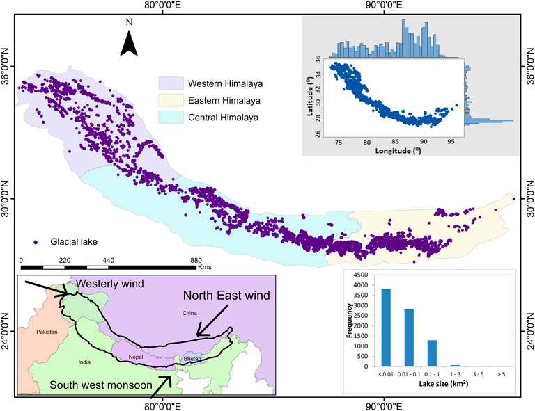
FIGURE 1. The Himalaya is taken as study area; here, dot with brown color shows the lake position in the study area. The violet color boundary shows the study area extent. Here, the scatter plot in the upper right corner shows the lake distribution along the latitude and longitude in the Himalaya, the histogram in the lower-left corner shows the lake size distribution in the Himalaya. Lake frequency distribution was also shown in another graph with respect to elevation.
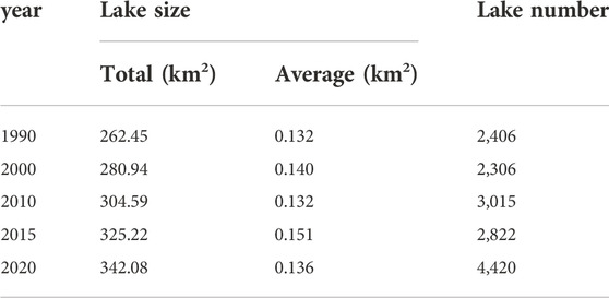
TABLE 1. Lake size and number variation in different years.
4.2 Characteristics of lake size expansion in the Himalaya
A total of 5,409 lakes was taken for the size expansion analysis, which excludes supraglacial lakes. We found a total lake size of 319.44 km2, 329.14 km2, 400.63 km2, 443.31 km2 and 605.31 km2 in 1990, 2000, 2010, 2015 and 2020, respectively. Besides, stable lakes (lakes present throughout the study period) showed a change rate of 30.53% during the study period, while lake size of 262.45km2, 280.94km2, 304.59km2, 325.22km2 and 342.08 km2 were found in 1990, 2000, 2010, 2015 and 2020, respectively. We also noted that during the recent decade (2015–2020) the change in lake size is relatively higher, followed by 2000–2010.
We found that the glacial lakes are increasing rapidly in the eastern side (i.e., middle Nepal, Bhutan, Sikkim and Everest region) than the rest of the Himalayas (Figure 2). The highest change was found in the Galongco lake (Nepal) followed by Gangxico (Nepal) and Thorthormi lake (Bhutan) (Figure 2). We also noted that 813 lakes were decreasing in their size over time. Upon manual investigation using high-resolution Google Earth images, we found that most of them are unconnected or glacier-fed lakes or erosional lakes. Moreover, some of the lakes were decreasing in size after the occurrence of the GLOF event (Tam Pokhari, some other lakes).
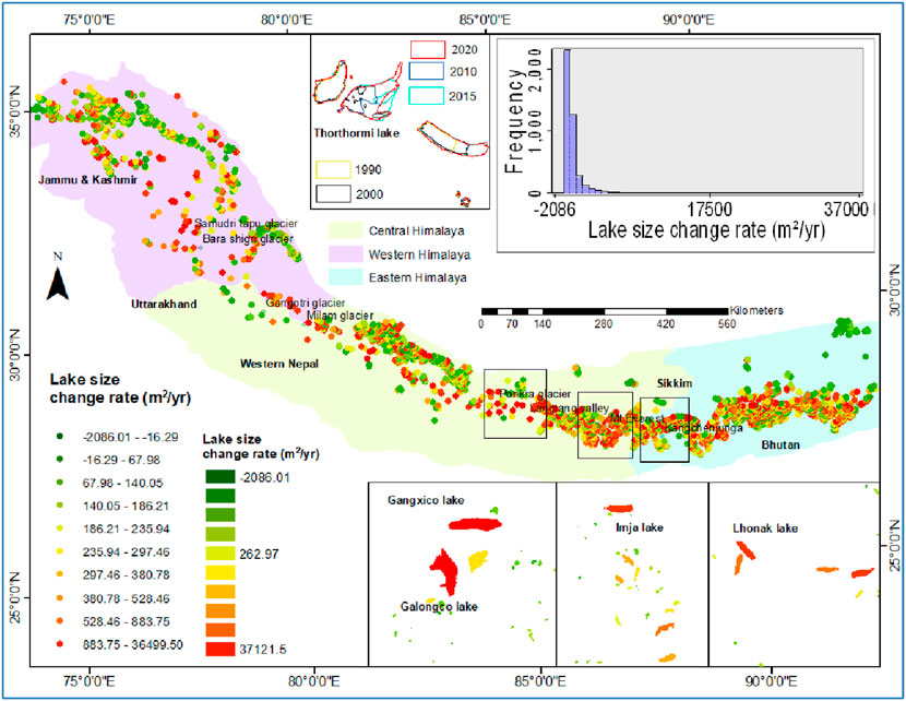
FIGURE 2. Lake size change rate map of the Himalaya; here, red color shows the highest positive, whereas green shows the lowest negative lake size change. In the zoom box important lakes were shown in different part of the Himalaya with their lake size change rate and different years of lake boundary polygon. In the histogram plot, the distribution of lake size change rate shown for the Himalaya.
4.3 Altitudinal distribution in glacial lake number, size and expansion
The total lake count and size is highest at an elevation between 4500 and 5500 m (Figure 3A). Consequently, a cluster of new lakes was found to develop at the higher elevations (>5000 m) over the years (Figure 3B). This is due to the continual increase in glacier retreat, creating glacier fragmentation. The glacial fragmentation helps to form new lakes at the contact between main glaciers and its tributary (Figure 4). This contact zone is usually at a higher elevation than the ablation area of a primary glacier.
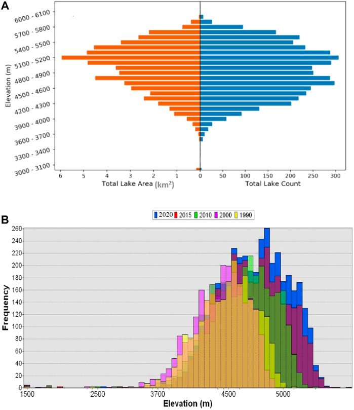
FIGURE 3. In (A) lake size and number distribution is shown for 2020 in different elevation band; while in (B) lake frequency distribution is shown in different color for various years (1990–2000-red, 2000–2010-cyne and 2010–2020-yellow) in different elevation zones of the Himalaya.
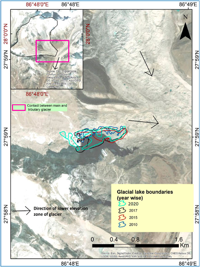
FIGURE 4. New proglacial lake is forming by coalensing at the tributary glacier (changri Nup) of Khumbhu glacier. Here, lake polygon in different years is shown in various color.
The average, standard deviation, and total lake size are continuously increasing since 1990 (Figures 5A,B). An increase in standard deviation refers to the higher variability in expansion over the time along with the formation of new smaller lakes. A sudden shift in lake size after the year 2000 was noticed due to the rapid increase in the lake size after the year 2000 (because of various underlying reasons such as faster glaciers melting). A crossover of the cumulative profile of lake size was seen for 2015 and 2020 at the elevation of 5000m, which shows that lakes are decreasing in size at elevation <5000 m. Additionally, for the elevation >5000m, an increase in the lake size was noticed in 2020, which happened because of the presence of a large number of proglacial connected lakes (Table 2). The highest and second-highest increase in lake size were found to happen between 2015–2020 and 2000–2010, respectively (Figure 5A). Moreover, out of 21 outburst phenomena (Table 3), seven occurred between 1990–2000; hence, these two cumulative profiles (2000 and 1990) are close to each other. The lake size expansion is higher between the elevation band 5000–5500m, followed by the elevation value >5500 m. The highest lake size change rate (819.17 m2/yr) was found over the elevations 5000–5500m, possibly due to the presence of maximum proglacial connected lakes (731). However, at a higher elevation (>5500 m), a lesser number of lakes were present; mostly connected moraine-dammed lakes (Table 2). For the elevations lesser than 4500m, the glacial lake size change rate was relatively slower. However, a minimal number of lakes exist at elevation >5500 m (515), followed by <4500m and 5000–5500 m (Table 2). The average lake size is higher at 5000–5500 m (0.17 km2) than the lakes present at 4500–5000 m (0.13 km2) and >5500 m (0.09 km2).

FIGURE 5. The graph plotted between elevation along X-axis with the cumulative lake size along Y-axis for different years (1990, 2000, 2010, 2015, 2020 and 2030) for the Himalaya glacial lakes (A). In (B), the average lake size was shown with standard deviation for different years.
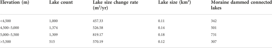
TABLE 2. Elevation wise lake characteristics distribution in the Himalaya.
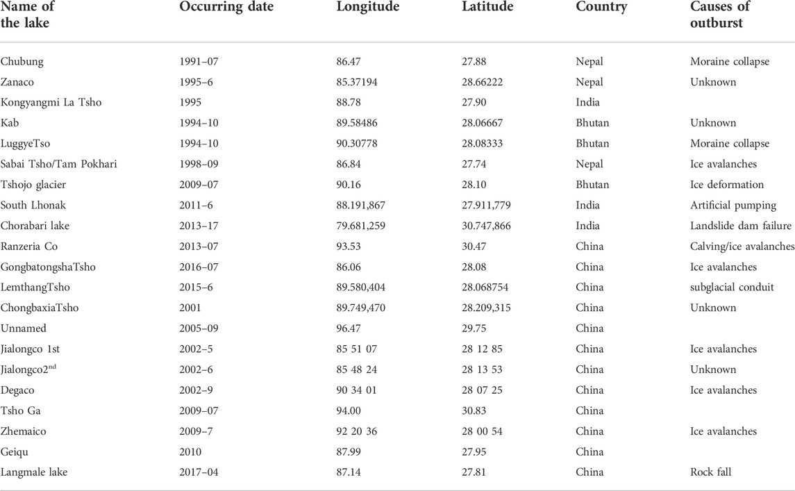
TABLE 3. Number, causes and locations of GLOF events reported in the Himalaya since 1990.
5 Discussion
5.1 Climatic control on glacial lakes distribution and expansion in Himalaya
Trend analysis of temperature and precipitation was calculated for the Himalayan region using APHRODITE dataset (Figure 6). It showed increasing precipitation mainly over the western Himalaya and central Himalaya. The temperature showed an increasing trend throughout Himalaya, having the highest warming trend over the central Himalaya. The western and eastern Himalaya showed warming, but with lesser intensity than central. At the same time, we found that the glacial lakes are increasing in number and size with a largest hotspot in the central Himalaya. The compound influence of both increased precipitation and temperature helped these lakes to grow in the central region of Himalaya. Albeit, the western region also received the increased precipitation, but due to the dominance of westerlies this precipitation falls mainly in a solid phase, however, over the central Himalaya, most of the precipitation falls in a liquid phase due to the dominance of the Indian Summer Monsoon. Therefore, the added energy flux through rain refreezing over the ice and increased temperature provide more water through melting to these glacial lakes that help them to grow further. Besides, we correlate the lake size change rate with the temperature and precipitation change rate in the Himalayan region and I got a R2 value of 0.39 and 0.25, respectively.
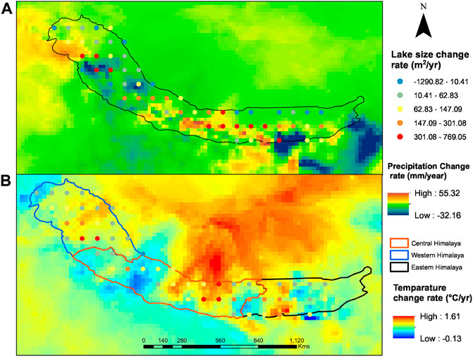
FIGURE 6. Precipitation (A) and temperature (B) change rate is shown with their corresponding average lake size change rate in the Himalaya.
Global Precipitation Climatology Project (GPCP) precipitation data showed a decreasing trend in the Himalaya from 1979 to 2010 (Huggel et al., 2002; Kaab, 2005; Kulkarni et al., 2011; Emmer and Vilímek, 2013). Moreover, Mohanty and Maiti. (2021b) showed a continuing decrease trend of precipitation amount in the Himalaya from 1998 to 2019. Moreover, Nie et al. (2017) also showed a decreasing trend of precipitation amount in most of the Himalayan from 1979 to 2014. The precipitation decrease in Himalaya was caused by the weakening in the Indian monsoon (Wu et al., 2005; Yao et al., 2012). The size of most of the non-glacial-fed lakes showed a declining trend caused by the decrease in the supply of precipitation; the same was observed in the Central Himalaya by Salerno et al. (2016) and Nie et al. (2017). However, most of the Himalayan glaciers are retreating at a higher rate, except for glaciers in Pamir, Hindu Kush, and the Karakoram in high Mountain Asia (Kaab et al., 2012; Gardelle et al., 2013; Vincent et al., 2016; Brun et al., 2017).
The impact of climate on glacial lakes is pretty complex. The addition of black soot particles to the glaciers causes darkening and accelerated glacier melting (Reynolds, 2000; Richardson and Reynolds, 2000; Scherler et al., 2011a; Ming et al., 2012; Vishwakarma et al., 2018). Black soot particles gather in the high altitude glaciers by the wind, after originating from industrial and fossil fuel combustion (Negi et al., 2019). Moreover, glaciers containing a lake/debris content, and clean glaciers have different retreat rates and responses to climate change (Racoviteanu et al., 2015; King et al., 2018). The glacier type, debris content and local topography have great control on the thinning and retreat pattern of the glaciers, as well as the precipitation and temperature pattern (Bhambri et al., 2011; Racoviteanu et al., 2015). These heterogeneities in glaciers varied across different parts of Himalaya i.e., western, eastern, and central (Bolch et al., 2012; Yao et al., 2012; Kaab et al., 2015).
5.2 Verification of lake size expansion and process associated
The highest lake size expansion rates were observed for proglacial lakes viz, a (Galongco), b (Gangxico), present in the Chinese Himalaya (Figure 7A). This observation is aligned with (Mayewski and Jeschke, 1979; Chen et al., 2007). The lake size expansion rate is lowest for the lake (a, b) from 2015 to 2020 due to a shorter period and also for mountain base came, where the snout detachment happened from lake surface (Figure 7). This expansion rate increases till the lake touches the base of the mountain where the slope is steep (the average slope of the lower part of the ablation area is 25°); after that the expansion of lake size slows down, and only volumetric growth happens. Moreover, the lake ‘c' is a permafrost lake where lake size expansion rate is always low. On the contrary, only the proglacial connected lakes will continue to grow at a higher rate, as in Figure 7B; these proglacial connected lakes also showed a higher lake size expansion rate. In Figure 7B, these lakes, possibly increase at a higher rate till the mountain base or higher relief zone comes. We noted the third highest lake size increase rate was shown by Thorthormi glacial lakes (Figure 2). This lake is present in the southern slope of Bhutan and formed by the coalescing of supraglacial lakes. The highest expansion rate of this lake happens because of the higher calving frontal width and the smaller size of mother glacier with higher debris content. Moreover, lakes formed by cleansing have a higher increase rate (Komori, 2008; Mohanty and Maiti, 2021b).
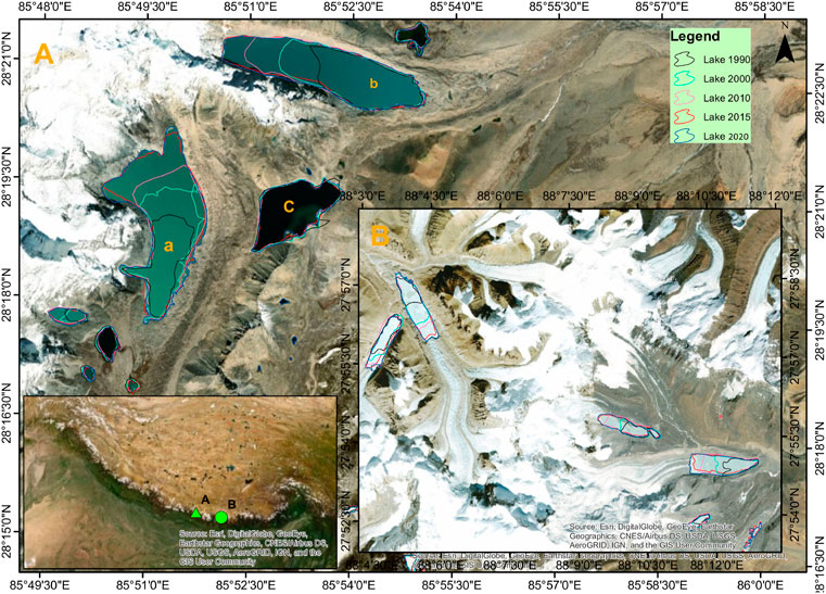
FIGURE 7. The growth process of proglacial lakes is shown. Figure (A) shows proglacial lakes (A,B) became connected to unconnected with time, whereas in figure (B), these proglacial lakes are remained connected.
A total of 813 (19%) lakes showed a negative lake size expansion rate in the whole Himalaya. Most of them are unconnected or erosion lakes or non-glacier fed lakes. Three types of processes can explain the reduction in lake size: lake outburst, partially drained by artificial draining, or natural and naturally dried by lowering in water input. The first and second type of lake size decrease is frequent in an ice-dammed or moraine-dammed lake, while the third happens only in unconnected or non-glacier-fed lakes. The lake becomes dangerous when lake volume increases; hence, artificially pumping could be done, as in Imja and Lhonak Lake (Kattelmann and Watanabe 1997). However, when lake water increases to higher extent, partial draining happens. A total of 21 lake outbursts events happened during the study period, and out of these, most of the GLOF occurred between the years 1990–2000. Moreover, many lake outbursts or partial draining phenomena were observed from previous studies and verified in this study (Table 3) (Figure 8).
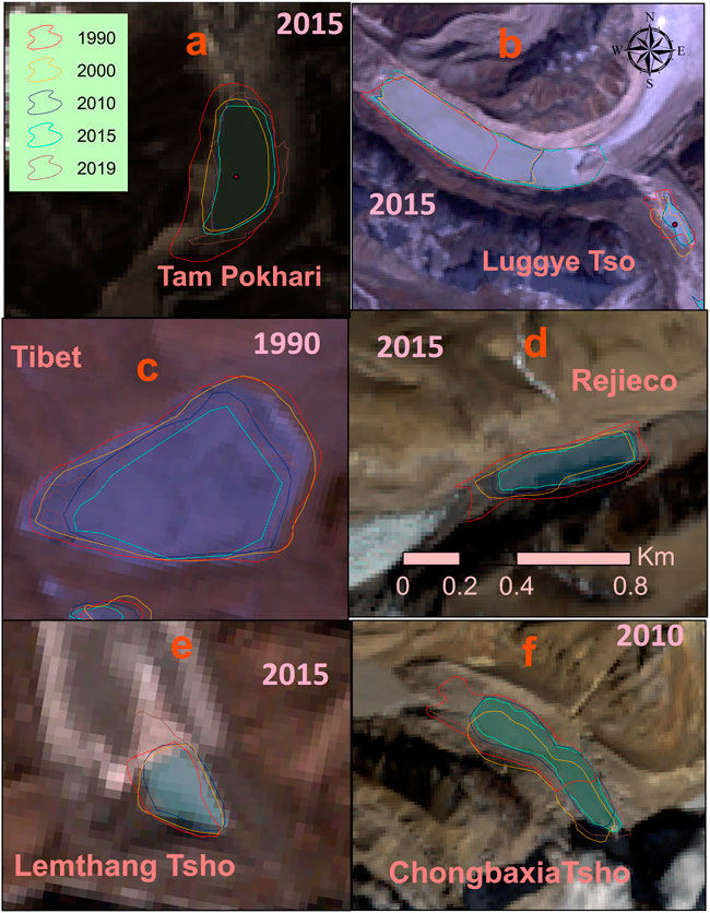
FIGURE 8. GLOF event verified in a different part of the Himalaya. Here, the GLOF occurrence in different parts of the Himalaya is shown: (A)-Tam Pokhari in Everest Himalaya, (B)-Luggey Tso in Bhutan region, (C) (Tibetan plateau close to Sikkim) sdown stream of lake-f, (D)-Rejico northern slope of Sikkim, (E)- Lamthang Tso southern slope of Bhutan and (F)-Chongbaxia Tso northern slope of Bhutan.
5.3 Fate of proglacial lakes
The bedrock slope is closely related to the surface slope of a glacier, i.e., steeper the surface, thinner the ice, and vice versa (Oerlemans, 2001). The continual increase in frontal loss leads to the detachment of proglacial-connected lakes when the glacier’s front comes to a zone of higher relief (steeper slope) (Figures 9A,C,D). Besides, due to the lesser slope in north Lhonak lake (Figure 9B) snout detachment could not have happened, causing a higher increase in lake size. On the other hand, the snout detachment is seen in (Figures 9A,C,D) due to the higher slope. This detachment is prominent for clean glaciers with lesser ice thickness. The glacier is unable to erode when the glacier subsurface rock is very hard; as a result, the sub-glacial relief will be high. This process is a typical case of most of the northern flowing glaciers, mostly in the Bhutan and Sikkim region, which flows over hard crystalline rocks (Nagai et al., 2013; Racoviteanu et al., 2015). Moreover, those glaciers have higher frontal and area loss due to lesser size and debris content (Scherler et al., 2011b; Bolch et al., 2012; Nagai et al., 2013; Ojha et al., 2017). Therefore, many lakes may get unconnected with time in the eastern and central Himalaya, as the glaciers present in those areas have a higher retreat rate (Bolch et al., 2012; Kulkarni and Karyakarte, 2014; Kaab et al., 2015; Racoviteanu et al., 2015; Brun et al., 2017). This detachment is possible because of a higher surface slope (>20%) at the lower part of the ablation area, observed from Google Earth (Figures 9A,B,D). Additionally, after the detachment of the lake, its expansion rate will be slowed down with time, if the current trend of temperature and precipitation prevails.
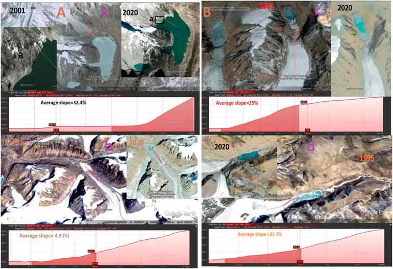
FIGURE 9. Surface slope of glaciers at lower part of ablation area, i.e., close to glacial lake. (A) Google Earth based observations of surface slope of glaciers temporarily (A) view in 2006 shows connected and (B) shows view in 2020 which became unconnected (B) GIS based procedures for future prediction of becoming unconnected based on slope of lower part of ablation area for Sikkim Himalayan connected lakes.
5.4 Comparison with previous work
A higher lake size and number change of 25%, 36% and 25%, 47% was noticed for the Himalayan region from datasets of Zhang et al. (2015) and our data set, respectively. Wang et al. (2020) showed a 15% and 10% increase in size and number for the HKH region from 1990–2018. Likewise, Xin et al. (2012) showed a 29% increase in lake size in the Chinese Himalaya from 1970–2000. A total of 7.02% of lake size expansion rate was shown in the Himalaya from 1990–2010 (Li and Sheng, 2012). Nie et al. (2013) showed that the glacial lakes expanded rapidly by 17.11% from 1990 to 2010 in the central Himalaya. The Himalayan lakes grew continuously between 1990 and 2009 by 20%–65% (Gardelle et al., 2011). Shukla et al. (2018) showed a lake size expansion rate of 24% for the Sikkim region from 1975 to 2017. However, the Hindu Kush and Karakoram regions showed a decrease in lake size expansion rate (Gardelle et al., 2013). This is due to the current trend in temperature and precipitation in that region, i.e., increasing precipitation. Hence, we can conclude that the lake size and number are increasing with time.
The greatest expansions occurred in the latitudinal zones between 4800m and 5600 m on the northern side and between 4500m and 5600 m on the southern side of the Himalaya (Song and Sheng, 2016). Here, a higher lake expansion rate between elevation zones 5000–5500 m was identified in the whole Himalaya. The expansion rate of southern side lakes is higher than the northern side lake (Kanamitsu et al., 2002; Kattelmann, 2003; Kulkarni et al., 2007; Komori, 2008; Nie et al., 2013; Veettil et al., 2016). Besides, Debnath et al. (2018) showed higher lake growth for the North aspect lakes in the Sikkim region. Here, we found the lake size expansion rate is higher for the southern side lakes for the whole Himalaya. Besides, We have also found a higher rate for glacier-fed lakes as reported by (Songchitruksa and Zeng, 2010; Singh et al., 2015) and Song et al. (2014).
5.5 Feature selection techniques
The feature selection algorithm was used to identify the importance of various controlling parameters (Manepalli et al., 2011). Here, the multiple regression analysis was used with 1,680 numbers of observations and 16 independent variables (viz., temperature change rate, precipitation change rate, proximal distance, calving width, size of mother glacier, lake size, lake type, lake width, lake length, slope, aspect and elevation), while lake size change rate was taken as dependent variable. Here, temperature change rate, glacier fed lake, glacier snout steepness, precipitation change rate and lake type gave higher weightage towards lake size change rate in regression analysis with a 95% confidence level. Besides, correlation matrix was created which showed lake type, proximal distance the glacier calving frontal width, mother glacier size, debris content, moraine dam and lake width gave higher weightage for lake size change rate.
6 Conclusion
• In the Himalaya glacial lake count (lake size >0.01 km2) has increased rate by approximately 2.98%/yr (30.53%) from 1990 to 2020. Most of the glacial lakes are gathered in Langtang, Everest, Sikkim and Bhutan regions at an elevation band of 4500–55000 m. Moreover, new lakes are continuously forming at higher elevation in the Himalaya and these are prominent where glacier fragmentation happens caused by glacier retreat.
• Besides, the average lake size expansion rate of 1.01%/yr was estimated for the Himalaya region. Furthermore, the majority of lake size expansion was noticed at an elevation band of 5000–5500 m due to the presence of the maximum number of moraine dam lakes.
• The lakes present in central and eastern Himalaya (Bhutan, Sikkim, Everest and Langtang) gave higher expansion rates, which is due to the decrease in the amount of precipitation and increase in temperature. Therefore, these regions are going to face the GLOF events depending on the local geomorphology.
• In future, the rate of glacial lake size increase will be slowed down, as some of the glacial lakes are going to be unconnected with continual frontal loss when a steep glacier subglacial topography comes.
Data availability statement
The raw data supporting the conclusion of this article will be made available by the authors, without undue reservation.
Author contributions
LM original drafting, data generation and plotting ADtemperature and precipitation data analysis correction SM supervision and interpretation.
Conflict of interest
The authors declare that the research was conducted in the absence of any commercial or financial relationships that could be construed as a potential conflict of interest.
Publisher’s note
All claims expressed in this article are solely those of the authors and do not necessarily represent those of their affiliated organizations, or those of the publisher, the editors and the reviewers. Any product that may be evaluated in this article, or claim that may be made by its manufacturer, is not guaranteed or endorsed by the publisher.
References
Aggarwal, A., Jain, S. K., Lohani, A. K., and Jain, N. (2016). Glacial lake outburst flood risk assessment using combined approaches of remote sensing, GIS and dam break modelling. Geomat. Nat. Hazards Risk 7 (1), 18–36. doi:10.1080/19475705.2013.862573
Aggarwal, S., Rai, S. C., Thakur, P. K., and Emmer, A. (2017). Inventory and recently increasing GLOF susceptibility of glacial lakes in Sikkim, Eastern Himalaya. Geomorphology 295, 39–54. doi:10.1016/j.geomorph.2017.06.014
Agrawal, A., Sharma, A. R., and Tayal, S. (2014). Assessment of regional climatic changes in the eastern himalayan region: A study using multi-satellite remote sensing data sets. Environ. Monit. Assess. 186 (10), 6521–6536. doi:10.1007/s10661-014-3871-x
Ali, G., Rasul, G., Mahmood, T., Zaman, Q., and Cheema, S. (2012). Validation of APHRODITE precipitation data for humid and sub humid regions of Pakistan. Pak J. Meteorol. 9, 1–10.
Anselin, L., and Getis, A. (1992). Spatial statistical analysis and geographic information systems. Ann. Reg. Sci. 26 (1), 19–33. doi:10.1007/bf01581478
Bajracharya, S. R., Mool, P. K., and Shrestha, B. R. (2008). Global climate change and melting of Himalayan glaciers. Melting glaciers and rising sea levels: Impacts and implications. India: The Icfai’s University Press, 28–46.
Bhambri, R., Bolch, T., Chaujar, R. K., and Kulshreshtha, S. C. (2011). Glacier changes in the Garhwal Himalaya, India, from 1968 to 2006 based on remote sensing. J. Glaciol. 57 (203), 543–556. doi:10.3189/002214311796905604
Bhambri, R., and Bolch, T. (2009). Glacier mapping: A review with special reference to the Indian Himalayas. Prog. Phys. Geogr. Earth Environ. 33 (5), 672–704. doi:10.1177/0309133309348112
Bolch, T., Buchroithner, M., Pieczonka, T., and Kunert, A. (2008). Planimetric and volumetric glacier changes in the Khumbu Himal, Nepal, since 1962 using Corona, Landsat TM and ASTER data. J. Glaciol. 54, 592–600. doi:10.3189/002214308786570782
Bolch, T., Kulkarni, A., Kääb, A., Huggel, C., Paul, F., Cogley, J. G., et al. (2012). The state and fate of Himalayan glaciers. Science 336 (6079), 310–314. doi:10.1126/science.1215828
Bookhagen, B., and Burbank, D. W. (2006). Topography, relief, and TRMM-derived rainfall variations along the Himalaya. Geophys. Res. Lett. 33 (8), L08405. doi:10.1029/2006gl026037
Bookhagen, B., and Burbank, D. W. (2010). Toward a complete Himalayan hydrological budget: Spatiotemporal distribution of snowmelt and rainfall and their impact on river discharge. J. Geophys. Res. 115 (3), F03019. doi:10.1029/2009jf001426
Brun, F., Berthier, E., Wagnon, P., Kääb, A., and Treichler, D. (2017). A spatially resolved estimate of High Mountain Asia glacier mass balances from 2000 to 2016. Nat. Geosci. 10 (9), 668–673. doi:10.1038/ngeo2999
Carrivick, J. L., and Tweed, F. S. (2016). A global assessment of the societal impacts of glacier outburst floods. Glob. Planet. Change 144, 1–16. doi:10.1016/j.gloplacha.2016.07.001
Chand, M. B., and Watanabe, T. (2019). Development of supraglacial ponds in the everest region, Nepal, between 1989 and 2018. Remote Sens. (Basel). 11 (9), 1058. doi:10.3390/rs11091058
Chen, X. Q., Cui, P., Li, Y., Yang, Z., and Qi, Y. Q. (2007). Changes in glacial lakes and glaciers of post-1986 in the poiqu river basin, nyalam, xizang (tibet). Geomorphology 88 (3-4), 298–311. doi:10.1016/j.geomorph.2006.11.012
Clague, J. J., and Evans, S. G. (2000). A review of catastrophic drainage of moraine-dammed lakes in British Columbia. Quat. Sci. Rev. 19 (17-18), 1763–1783. doi:10.1016/s0277-3791(00)00090-1
Cramer, W., Yohe, G., and Field, C. B. (2014). Detection and attribution of observed impacts. United Kingdom: Cambridge University Press, 979–1037.
Das, S., Kar, N. S., and Bandyopadhyay, S. (2015). Glacial lake outburst flood at kedarnath, Indian Himalaya: A study using digital elevation models and satellite images. Nat. Hazards (Dordr). 77 (2), 769–786. doi:10.1007/s11069-015-1629-6
Debnath, M., Syiemlieh, H. J., Sharma, M. C., Kumar, R., Chowdhury, A., and Lal, U. (2018). Glacial lake dynamics and lake surface temperature assessment along the Kangchengayo-Pauhunri Massif, Sikkim Himalaya, 1988–2014. Remote Sens. Appl. Soc. Environ. 9, 26–41. doi:10.1016/j.rsase.2017.11.002
Dixit, A., Sahany, S., and Kulkarni, A. V. (2021). Glacial changes over the Himalayan Beas basin under global warming. J. Environ. Manage. 295, 113101. doi:10.1016/j.jenvman.2021.113101
Emmer, A., Klimeš, J., Mergili, M., Vilímek, V., and Cochachin, A. (2016). 882 lakes of the cordillera blanca: An inventory, classification, evolution and assessment of susceptibility to outburst floods. Catena 147, 269–279. doi:10.1016/j.catena.2016.07.032
Emmer, A., Vilímek, V., Klimeš, J., and Cochachin, A. (2014). “Glacier retreat, lakes development and associated natural hazards in Cordilera Blanca, Peru,” in Landslides in cold regions in the context of climate change (Cham: Springer), 231–252.
Emmer, A., and Vilímek, V. (2013). Review article: Lake and breach hazard assessment for moraine-dammed lakes: An example from the cordillera blanca (Peru). Nat. Hazards Earth Syst. Sci. 13 (6), 1551–1565. doi:10.5194/nhess-13-1551-2013
Gardelle, J., Arnaud, Y., and Berthier, E. (2011). Contrasted evolution of glacial lakes along the Hindu Kush Himalaya mountain range between 1990 and 2009. Glob. Planet. Change 75 (1), 47–55. doi:10.1016/j.gloplacha.2010.10.003
Gardelle, J., Berthier, E., Arnaud, Y., and Kääb, A. (2013). Corrigendum to "Region-wide glacier mass balances over the Pamir-Karakoram-Himalaya during 1999–2011&quot; published in the Cryosphere. Cryosphere 7 (6), 1885–1886. doi:10.5194/tc-7-1885-2013
Govindha Raj, K. B. (2010). Remote sensing based hazard assessment of glacial lakes: A case study in zanskar basin, Jammu and Kashmir, India. Geomatics, Nat. Hazards Risk 1 (4), 339–347. doi:10.1080/19475705.2010.532973
Harrison, S., Kargel, J. S., Huggel, C., Reynolds, J., Shugar, D. H., Betts, R. A., et al. (2018). Climate change and the global pattern of moraine-dammed glacial lake outburst floods. Cryosphere 12 (4), 1195–1209. doi:10.5194/tc-12-1195-2018
Huggel, C., Kääb, A., Haeberli, W., Teysseire, P., and Paul, F. (2002). Remote sensing based assessment of hazards from glacier lake outbursts: A case study in the Swiss alps. Can. Geotech. J. 39 (2), 316–330. doi:10.1139/t01-099
Jeelani, G. H., Bhat, N. A., Shivanna, K., and Bhat, M. Y. (2011). Geochemical characterization of surface water and spring water in SE Kashmir valley, Western Himalaya: Implications to water–rock interaction. J. Earth Syst. Sci. 120 (5), 921–932. doi:10.1007/s12040-011-0107-0
Kaab, A., Berthier, E., Nuth, C., Gardelle, J., and Arnaud, Y. (2012). Contrasting patterns of early twenty-first-century glacier mass change in the Himalayas. Nature 488 (7412), 495–498. doi:10.1038/nature11324
Kaab, A. (2005). Combination of SRTM3 and repeat ASTER data for deriving alpine glacier flow velocities in the Bhutan Himalaya. Remote Sens. Environ. 94 (4), 463–474. doi:10.1016/j.rse.2004.11.003
Kaab, A., Treichler, D., Nuth, C., and Berthier, E. (2015). Brief communication: Contending estimates of 2003–2008 glacier mass balance over the pamir–karakoram–himalaya. Cryosphere 9 (2), 557–564. doi:10.5194/tc-9-557-2015
Kanamitsu, M., Ebisuzaki, W., Woollen, J., Yang, S. K., Hnilo, J. J., Fiorino, M., et al. (2002). Ncep–doe amip-ii reanalysis (r-2). Bull. Am. Meteorol. Soc. 83 (11), 1631–1643. doi:10.1175/bams-83-11-1631(2002)083<1631:nar>2.3.co;2
Kargel, J. S., Abrams, M. J., Bishop, M. P., Bush, A., Hamilton, G., Jiskoot, H., et al. (2005). Multispectral imaging contributions to global land ice measurements from space. Remote Sens. Environ. 99 (1), 187–219. doi:10.1016/j.rse.2005.07.004
Kattelmann, R. (2003). Glacial lake outburst floods in the Nepal Himalaya: A manageable hazard. Nat. Hazard. 28 (1), 145–154. doi:10.1023/A:1021130101283
Kattelmann, R., and Watanabe, T. (1997). Draining Himalayan glacial lakes before they burst. IAHS Publications-Series Proc. Reports-Intern Assoc Hydrological Sci. 239, 337–344.
King, O., Dehecq, A., Quincey, D., and Carrivick, J. (2018). Contrasting geometric and dynamic evolution of lake and land-terminating glaciers in the central Himalaya. Glob. Planet. Change 167, 46–60. doi:10.1016/j.gloplacha.2018.05.006
Komori, J. (2008). Recent expansions of glacial lakes in the Bhutan Himalayas. Quat. Int. 184 (1), 177–186. doi:10.1016/j.quaint.2007.09.012
Kulkarni, A. V., Bahuguna, I. M., Rathore, B. P., Singh, S. K., Randhawa, S. S., Sood, R. K., et al. (2007). Glacial retreat in Himalaya using Indian remote sensing satellite data. Curr. Sci. 135, 69–74.
Kulkarni, A. V., and Karyakarte, Y. (2014). Observed changes in Himalayan glaciers. Curr. Sci. 123, 237–244.
Kulkarni, A. V., Rathore, B. P., Singh, S. K., and Bahuguna, I. M. (2011). Understanding changes in the Himalayan cryosphere using remote sensing techniques. Int. J. Remote Sens. 32 (3), 601–615. doi:10.1080/01431161.2010.517802
Li, J., and Sheng, Y. (2012). An automated scheme for glacial lake dynamics mapping using Landsat imagery and digital elevation models: A case study in the Himalayas. Int. J. Remote Sens. 33 (16), 5194–5213. doi:10.1080/01431161.2012.657370
Manepalli, U. R., Bham, G. H., and Kandada, S. (2011). “Evaluation of hotspots identification using kernel density estimation (K) and Getis-Ord (Gi*) on I-630,” in 3rd International Conference on Road Safety and Simulation, 21 September 2011 (San Diego: IEEE), 14–16.
Mayewski, P. A., and Jeschke, P. A. (1979). Himalayan and Trans-Himalayan glacier fluctuations since AD 1812. Arct. Alp. Res. 11 (3), 267–287. doi:10.2307/1550417
Ming, J., Du, Z., Xiao, C., Xu, X., and Zhang, D. (2012). Darkening of the mid-Himalaya glaciers since 2000 and the potential causes. Environ. Res. Lett. 7 (1), 014021. doi:10.1088/1748-9326/7/1/014021
Mir, R. A., Jain, S. K., Lohani, A. K., and Saraf, A. K. (2018). Glacier recession and glacial lake outburst flood studies in Zanskar basin, Western Himalaya. J. Hydrol. X. 564, 376–396. doi:10.1016/j.jhydrol.2018.05.031
Mohanty, L. K., and Maiti, S. (2021b). Probability of glacial lake outburst flooding in the Himalaya. Resour. Environ. Sustain. 5, 100031. doi:10.1016/j.resenv.2021.100031
Mohanty, L. K., and Maiti, S. (2021a). Regional morphodynamics of supraglacial lakes in the Everest Himalaya. Sci. Total Environ. 751, 141586. doi:10.1016/j.scitotenv.2020.141586
Mool, P. K., Wangda, D., Bajracharya, S. R., KarmaGurung, D. R., and Joshi, S. P. (2001). Inventory of glaciers, Glacial Lakes and Glacial Lake outburst floods, Bhutan. Kathmandu: ICIMOD, 247.
Nagai, H., Fujita, K., Nuimura, T., and Sakai, A. (2013). Southwest-facing slopes control the formation of debris-covered glaciers in the Bhutan Himalaya. Cryosphere 7 (4), 1303–1314. doi:10.5194/tc-7-1303-2013
Negi, P. S., Pandey, C. P., and Singh, N. (2019). Black carbon aerosols in the ambient air of Gangotri Glacier valley of north-Western Himalaya in India. Atmos. Environ. X. 214, 116879. doi:10.1016/j.atmosenv.2019.116879
Nie, Y., Liu, Q., and Liu, S. (2013). Glacial lake expansion in the central Himalayas by Landsat images, 1990–2010. PloS one 8 (12), e83973. doi:10.1371/journal.pone.0083973
Nie, Y., Sheng, Y., Liu, Q., Liu, L., Liu, S., Zhang, Y., et al. (2017). A regional-scale assessment of Himalayan glacial lake changes using satellite observations from 1990 to 2015. Remote Sens. Environ. 189, 1–13. doi:10.1016/j.rse.2016.11.008
Ojha, S., Fujita, K., Sakai, A., Nagai, H., and Lamsal, D. (2017). Topographic controls on the debris-cover extent of glaciers in the Eastern Himalayas: Regional analysis using a novel high-resolution glacier inventory. Quat. Int. 455, 82–92. doi:10.1016/j.quaint.2017.08.007
Ord, J. K., and Getis, A. (1995). Local spatial autocorrelation statistics: Distributional issues and an application. Geogr. Anal. 27 (4), 286–306. doi:10.1111/j.1538-4632.1995.tb00912.x
Pandey, P., Ali, S. N., and Champati Ray, P. K. (2021). Glacier-glacial lake interactions and glacial lake development in the central Himalaya, India (1994–2017). J. Earth Sci. 32 (6), 1563–1574. doi:10.1007/s12583-020-1056-9
Pandey, P., Ali, S. N., Ramanathan, A. L., and Venkataraman, G. (2017). Regional representation of glaciers in chandra basin region, Western Himalaya, India. Geosci. Front. 8 (4), 841–850. doi:10.1016/j.gsf.2016.06.006
Qiao, B., and Zhu, L. (2019). Difference and cause analysis of water storage changes for glacier-fed and non-glacier-fed lakes on the Tibetan Plateau. Sci. Total Environ. 693, 133399. doi:10.1016/j.scitotenv.2019.07.205
Racoviteanu, A. E., Arnaud, Y., Williams, M. W., and Manley, W. F. (2015). Spatial patterns in glacier characteristics and area changes from 1962 to 2006 in the Kanchenjunga-Sikkim area, eastern Himalaya. Cryosphere 9 (2), 505–523. doi:10.5194/tc-9-505-2015
Raj, K. B. G., and Kumar, K. V. (2016). Inventory of glacial lakes and its evolution in Uttarakhand Himalaya using time-series satellite data. J. Indian Soc. Remote Sens. 44 (6), 959–976. doi:10.1007/s12524-016-0560-y
Rashid, I., and Majeed, U. (2018). Recent recession and potential future lake formation on Drang Drung glacier, Zanskar Himalaya, as assessed with Earth observation data and glacier modelling. Environ. Earth Sci. 77 (12), 429–513. doi:10.1007/s12665-018-7601-5
Reynolds, J. M. (2000). On the formation of supraglacial lakes on debris-covered glaciers. India: IAHS Publ, 153–161.
Richardson, S. D., and Reynolds, J. M. (2000). An overview of glacial hazards in the Himalayas. Quat. Int. 65, 31–47. doi:10.1016/s1040-6182(99)00035-x
Rubatto, D., Chakraborty, S., and Dasgupta, S. (2013). Timescales of crustal melting in the Higher Himalayan Crystallines (Sikkim, Eastern Himalaya) inferred from trace element-constrained monazite and zircon chronology. Contrib. Mineral. Pet. 165 (2), 349–372. doi:10.1007/s00410-012-0812-y
Salerno, F., Rogora, M., Balestrini, R., Lami, A., Tartari, G. A., Thakuri, S., et al. (2016). Glacier melting increases the solute concentrations of Himalayan glacial lakes. Environ. Sci. Technol. 50 (17), 9150–9160. doi:10.1021/acs.est.6b02735
Scherler, D., Bookhagen, B., and Strecker, M. R. (2011b). Hillslope-glacier coupling: The interplay of topography and glacial dynamics in High Asia. J. Geophys. Res. 116 (2), 001751. doi:10.1029/2010jf001751
Scherler, D., Bookhagen, B., and Strecker, M. R. (2011a). Spatially variable response of Himalayan glaciers to climate change affected by debris cover. Nat. Geosci. 4 (3), 156–159. doi:10.1038/ngeo1068
Shrestha, A. B., and Aryal, R. (2011). Climate change in Nepal and its impact on Himalayan glaciers. Reg. Environ. Change 11 (1), 65–77. doi:10.1007/s10113-010-0174-9
Shugar, D. H., Burr, A., Haritashya, U. K., Kargel, J. S., Watson, C. S., Kennedy, M. C., et al. (2020). Rapid worldwide growth of glacial lakes since 1990. Nat. Clim. Chang. 10 (10), 939–945. doi:10.1038/s41558-020-0855-4
Shukla, A., Garg, P. K., and Srivastava, S. (2018). Evolution of glacial and high-altitude lakes in the Sikkim, Eastern Himalaya over the past four decades (1975–2017). Front. Environ. Sci. 6, 81. doi:10.3389/fenvs.2018.00081
Singh, V. B., Ramanathan, A. L., and Sharma, P. (2015). Major ion chemistry and assessment of weathering processes of the Patsio glacier meltwater, Western Himalaya, India. Environ. Earth Sci. 73 (1), 387–397. doi:10.1007/s12665-014-3432-1
Song, C., Huang, B., Ke, L., and Richards, K. S. (2014). Remote sensing of alpine lake water environment changes on the Tibetan plateau and surroundings: A review. ISPRS J. Photogramm. Remote Sens. 92, 26–37. doi:10.1016/j.isprsjprs.2014.03.001
Song, C., and Sheng, Y. (2016). Contrasting evolution patterns between glacier-fed and non-glacier-fed lakes in the Tanggula Mountains and climate cause analysis. Clim. change 135 (3-4), 493–507. doi:10.1007/s10584-015-1578-9
Song, C., Sheng, Y., Wang, J., Ke, L., Madson, A., and Nie, Y. (2017). Heterogeneous glacial lake changes and links of lake expansions to the rapid thinning of adjacent glacier termini in the Himalayas. Geomorphology 280, 30–38. doi:10.1016/j.geomorph.2016.12.002
Songchitruksa, P., and Zeng, X. (2010). Getis–Ord spatial statistics to identify hot spots by using incident management data. Transp. Res. Rec. 2165 (1), 42–51. doi:10.3141/2165-05
Sunilkumar, K., Yatagai, A., and Masuda, M. (2019). Preliminary evaluation of GPM-IMERG rainfall estimates over three distinct climate zones with APHRODITE. Earth Space Sci. 6 (8), 1321–1335. doi:10.1029/2018ea000503
Taylor, C. J., and Carr, J. R. (2019). Supraglacial pond evolution in the Everest region, central Himalaya, 2015–2018. Cryosphere Discuss. 25, 1–33. doi:10.5194/tc-2019-12
Taylor, P. C., Cai, M., Hu, A., Meehl, J., Washington, W., and Zhang, G. J. (2013). A decomposition of feedback contributions to polar warming amplification. J. Clim. 26 (18), 7023–7043. doi:10.1175/jcli-d-12-00696.1
Veettil, B. K., Bianchini, N., de Andrade, A. M., Bremer, U. F., Simões, J. C., and de Souza Junior, E. (2016). Glacier changes and related glacial lake expansion in the Bhutan Himalaya, 1990–2010. Reg. Environ. Change 16 (5), 1267–1278. doi:10.1007/s10113-015-0853-7
Veh, G., Korup, O., Roessner, S., and Walz, A. (2018). Detecting Himalayan glacial lake outburst floods from Landsat time series. Remote Sens. Environ. 207, 84–97. doi:10.1016/j.rse.2017.12.025
Veh, G., Korup, O., von Specht, S., Roessner, S., and Walz, A. (2019). Unchanged frequency of moraine-dammed glacial lake outburst floods in the Himalaya. Nat. Clim. Chang. 9 (5), 379–383. doi:10.1038/s41558-019-0437-5
Vincent, C., Wagnon, P., Shea, J. M., Immerzeel, W. W., Kraaijenbrink, P., Shrestha, D., et al. (2016). Reduced melt on debris-covered glaciers: Investigations from changri Nup glacier, Nepal. Cryosphere 10 (4), 1845–1858. doi:10.5194/tc-10-1845-2016
Vishwakarma, C. A., Sen, R., Singh, N., Singh, P., Rena, V., Rina, K., et al. (2018). Geochemical characterization and controlling factors of chemical composition of spring water in a part of Eastern Himalaya. J. Geol. Soc. India 92 (6), 753–763. doi:10.1007/s12594-018-1098-0
Wang, X., Guo, X., Yang, C., Liu, Q., Wei, J., Zhang, Y., et al. (2020). Glacial lake inventory of high-mountain Asia in 1990 and 2018 derived from Landsat images. Earth Syst. Sci. Data 12 (3), 2169–2182. doi:10.5194/essd-12-2169-2020
Wang, X., Siegert, F., Zhou, A. G., and Franke, J. (2013). Glacier and glacial lake changes and their relationship in the context of climate change, Central Tibetan Plateau 1972–2010. Glob. Planet. Change 111, 246–257. doi:10.1016/j.gloplacha.2013.09.011
Watson, C. S., Quincey, D. J., Carrivick, J. L., Smith, M. W., Rowan, A. V., and Richardson, R. (2018). Heterogeneous water storage and thermal regime of supraglacial ponds on debris-covered glaciers. Earth Surf. Process. Landf. 43 (1), 229–241. doi:10.1002/esp.4236
Wessel, B., Huber, M., Wohlfart, C., Marschalk, U., Kosmann, D., and Roth, A. (2018). Accuracy assessment of the global TanDEM-X digital elevation Model with GPS data. ISPRS J. Photogramm. Remote Sens. 139, 171–182. doi:10.1016/j.isprsjprs.2018.02.017
Worni, R., Huggel, C., and Stoffel, M. (2013). Glacial lakes in the Indian Himalayas—from an area-wide glacial lake inventory to on-site and modeling based risk assessment of critical glacial lakes. Sci. Total Environ. 468, S71–S84. doi:10.1016/j.scitotenv.2012.11.043
Wu, H., Hayes, M. J., Wilhite, D. A., and Svoboda, M. D. (2005). The effect of the length of record on the standardized precipitation index calculation. Int. J. Climatol. 25 (4), 505–520. doi:10.1002/joc.1142
Xin, W., Shiyin, L., Wanqin, G., Xiaojun, Y., Zongli, J., and Yongshun, H. (2012). Using remote sensing data to quantify changes in glacial lakes in the Chinese Himalaya. Mt. Res. Dev. 32 (2), 203–212. doi:10.1659/mrd-journal-d-11-00044.1
Yao, T., Thompson, L., Yang, W., Yu, W., Gao, Y., Guo, X., et al. (2012). Different glacier status with atmospheric circulations in Tibetan Plateau and surroundings. Nat. Clim. Chang. 2 (9), 663–667. doi:10.1038/nclimate1580
Yao, X., Liu, S., Han, L., Sun, M., and Zhao, L. (2018). Definition and classification system of glacial lake for inventory and hazards study. J. Geogr. Sci. 28 (2), 193–205. doi:10.1007/s11442-018-1467-z
Zhang, G., Yao, T., Xie, H., Wang, W., and Yang, W. (2015). An inventory of glacial lakes in the Third Pole region and their changes in response to global warming. Glob. Planet. Change 131, 148–157. doi:10.1016/j.gloplacha.2015.05.013
Keywords: glacier, glacial lake, hazard, Himalaya, GLOF
Citation: Mohanty L, Maiti S and Dixit A (2023) Spatio-temporal assessment of regional scale evolution and distribution of glacial lakes in Himalaya. Front. Earth Sci. 10:1038777. doi: 10.3389/feart.2022.1038777
Received: 07 September 2022; Accepted: 18 November 2022;
Published: 09 January 2023.
Edited by:
Hongjie Xie, University of Texas at San Antonio, United StatesReviewed by:
Weicai Wang, Institute of Tibetan Plateau Research (CAS), ChinaJida Wang, Kansas State University, United States
Copyright © 2023 Mohanty, Maiti and Dixit. This is an open-access article distributed under the terms of the Creative Commons Attribution License (CC BY). The use, distribution or reproduction in other forums is permitted, provided the original author(s) and the copyright owner(s) are credited and that the original publication in this journal is cited, in accordance with accepted academic practice. No use, distribution or reproduction is permitted which does not comply with these terms.
*Correspondence: Litan Mohanty, mohanty.litan.geo@gmail.com; Sabyasachi Maiti, maiti@gg.iitkgp.ac.in
†ORCID: Sabyasachi Maiti, orcid.org/0000-0001-9142-0411