A Novel Phase Unwrapping Method Used for Monitoring the Land Subsidence in Coal Mining Area Based on U-Net Convolutional Neural Network
 Zhiyong Wang
 Lu Li2
 - 1College of Geodesy and Geomatics, Shandong University of Science and Technology, Qingdao, China
- 2Changzhou Construction Research Institute Group Co., Ltd, Changzhou, China
Large-scale and high-intensity mining underground coal has resulted in serious land subsidence. It has caused a lot of ecological environment problems and has a serious impact on the sustainable development of economy. Land subsidence cannot be accurately monitored by InSAR (interferometric synthetic aperture radar) due to the low coherence in the mining area, excessive deformation gradient, and the atmospheric effect. In order to solve this problem, a novel phase unwrapping method based on U-Net convolutional neural network was constructed. Firstly, the U-Net convolutional neural network is used to extract edge to automatically obtain the boundary information of the interferometric fringes in the region of subsidence basin. Secondly, an edge-linking algorithm is constructed based on edge growth and predictive search. The interrupted interferometric fringes are connected automatically. The whole and continuous edges of interferometric fringes are obtained. Finally, the correct phase unwrapping results are obtained according to the principle of phase unwrapping and the wrap-count (integer jump of 2π) at each pixel by edge detection. The Huaibei Coalfield in China was taken as the study area. The real interferograms from D-InSAR (differential interferometric synthetic aperture radar) processing used Sentinel-1A data which were used to verify the performance of the new method. Subsidence basins with clear interferometric fringes, interrupted interferometric fringes, and confused interferometric fringes are selected for experiments. The results were compared with the other methods, such as MCF (minimum cost flow) method. The tests showed that the new method based on U-Net convolutional neural network can resolve the problem that is difficult to obtain the correct unwrapping phase due to interrupted or partially confused interferometric fringes caused by low coherence or other reasons in the coal mining area. Hence, the new method can help to accurately monitor the subsidence in mining areas under different conditions using InSAR technology.
Introduction
The coal industry is a significant part of China’s energy system. On the one hand, coal mining has promoted the rapid development of China’s economy and made great contributions to social development (Fan et al., 2014; Chen et al., 2020a). On the other hand, wide-spread and high-intensity mining of underground coal resources for a long time has caused some serious problems of ground subsidence and damaged the ecological environment, such as the subsidence of building foundations, the cracking of wall, the destruction of farmland, and the abandonment of land resources (Zhou et al., 2013). Moreover, mining coal also has caused soil erosion, debris flow, and other geological disasters, which endanger the life and property safety of the people in the mining area and seriously restrict the sustainable development of the mining areas. Therefore, it is particularly important to continuously monitor the land subsidence caused by mining underground mineral resources.
With the development of geodetic surveying technology, more and more new technologies are applied to monitor the mining subsidence (Zhou et al., 2009; Xia et al., 2018; Chen et al., 2020a). Among those technologies, as a research hotspot, InSAR technology can monitor large area deformation with all-weather imaging capability and day/night data acquisition (Du et al., 2016; Ma et al., 2016; Ng et al., 2017; Yang et al., 2018; Zheng et al., 2018). The study of monitoring the subsidence in mining areas using InSAR technology began in 1996 (Carnec et al., 1996). Carnec et al. researched the subsidence of French Gardanne coal mine and found a large annular subsidence area through SAR images at intervals of 35 days. D-InSAR technology was used to monitor a salt mine in Vauvert region of France and optimized the ground level observation plan according to the monitoring results (Carnec et al., 1996; Raucoules et al., 2003). The classical approach of differential radar interferometry (D-InSAR) with short temporal baselines (6 days) was used and the radar results were compared with prediction models based on the Knothe–Budryk theory for mining subsidence (Ilieva et al., 2019). Zheng et al. analyzed land subsidence induced by coal mining in a 200 km2 area in the Ordos Basin for the time period 2006–2015 using SBAS InSAR and D-InSAR (Zheng et al., 2020). Pawluszek-Filipiak et al. indicated that the Kriging-based integration method of D-InSAR and SBAS can be effectively applied to monitor mining-related subsidence (Pawluszek-Filipiak and Borkowski, 2020). Malinowska et al. evaluated the impact of mining-induced earthquakes in Poland through time-series InSAR technology (Malinowska et al., 2018). Pawel et al. focused on describing vertical surface displacements in the Upper Silesian Coal Basin in the south of Poland (Pawel et al., 2020). The surface deformations are identified using D-InSAR technology. A D-InSAR-based illegal-mining detection system (DIMDS) was proposed to exploit the geometric, spatial, and temporal characteristics of those subsidence patterns (Hu et al., 2013). It can be seen that InSAR technology has become a new technical means of mining subsidence monitoring.
Due to the complexity of mining environment and the limitation of InSAR technology, the accuracy and reliability of InSAR in monitoring the mining subsidence are not high. Low coherence, excessive deformation gradient, interferometric phase discontinuity caused by large displacement, and the atmospheric effect will influence the accuracy of InSAR technology when monitoring the deformation in the mining area (Chen et al., 2021). The deformation in the mining area is special, which is mainly characterized by uneven settlement rate, large deformation in the mining area, and small and dispersive settlement range (Fan et al., 2014; Du et al., 2016; Du et al., 2019). In addition, the surface of the mining area is mostly covered by vegetation and farmland, which leads to the low coherence of interferometric pair. In order to improve the accuracy and reliability of InSAR monitoring results, it is necessary to combine InSAR technology with other methods. For example, a method that relied on the principle of the probability integral method (PIM) and interferometric synthetic aperture radar (InSAR) was proposed to retrieve the location of an underground goaf (Xia and Wang, 2020). A solution was proposed to obtain complete deformation fields using the probability integral method to fuse deformation data derived from differential interferometric SAR (D-InSAR), sub-band InSAR, and offset-tracking (Wang et al., 2020). Du et al. used the probability integral method (PIM) and D-InSAR to locate the goaf (Du et al., 2019). An improvement of PSI processing, named as external model-based deformation decomposition PSI (EMDD-PSI) was proposed to address the limitations when monitoring large gradient deformations when there is phase ambiguity (Du et al., 2020). Liu et al. obtained the spatial–temporal characteristics of land subsidence caused by drilling solution mining activities using the time-series analysis (Liu et al., 2019). Sui et al. proposed an approach based on a combination of a differential interferometric synthetic aperture radar (D-InSAR) technique and a support vector machine (SVM) regression algorithm optimized by grid search (GS-SVR) to predict mining subsidence (Sui et al., 2020). Chen et al. employed the small baseline subset interferometric synthetic aperture radar (SBAS-InSAR) technology to obtain the time-series residual surface deformation based on the 40 Sentinel-1A images acquired from February 14, 2017, to May 17, 2020 (Chen et al., 2020b).
With the continuous development of InSAR technology, the applications of InSAR technology for monitoring the mine subsidence are also increasing. The main research directions have evolved from obtaining single surface deformation information to parameter inversion or subsidence prediction based on deformation theory (Du et al., 2019; Sui et al., 2020; Wang et al., 2020). Most of these works are targeted at one or more subsidence basins, which have high requirements on the interferogram and phase unwrapping quality of the interferometric pair. But influenced by the complex surface environment of the mining area, interferograms are seriously affected by noise which will interrupt or confuse the interferometric fringes.
Phase unwrapping is an important factor affecting the accuracy of InSAR measurement (Wang et al., 2017). Although many methods for InSAR phase unwrapping have been proposed (Chiglia and Pritt, 1998; Costantini, 1998; Xu et al., 2016; Wang et al., 2017; Yu et al., 2019; Luo et al., 2020; Liu and Pan, 2020; Zhou et al., 2020; Sica et al., 2020; Dai et al., 2020; Gao et al., 2020), traditional methods cannot unwrap the interferometric phase correctly and the reliability of InSAR monitoring results is not high in monitoring the large deformation in the mining areas. There are several learning-based phase unwrapping methods, including back-projection neural network in 1D phase unwrapping (Tipper et al., 1996; Hamzah et al., 1997), supervised feedforward multilayer perceptron neural network for 2D phase unwrapping (Schwartzkopf et al., 2000), a deep learning-based phase unwrapping network that uses the fully convolutional network (FCN) (Spoorthi et al., 2019), and also a deep convolutional neural network-based robust phase gradient estimation for 2D phase unwrapping (Li et al., 2020). Sica et al. also proposed a convolutional neural network-based coherence-driven approach for InSAR phase unwrapping (Sica et al., 2020). So, a reliable phase unwrapping method is still the guarantee for obtaining reliable land subsidence with high precision using SAR interferometry.
When monitoring the subsidence in the coal mining area using InSAR technology, the interferometric fringes are usually interrupted or confused because the interferograms are contaminated by noise or other reasons, so the existing phase unwrapping methods are difficult to accurately realize the phase unwrapping. To solve this problem, a novel phase unwrapping method based on the characteristics of subsidence basin is proposed in this paper. First, a U-Net convolutional neural network is introduced into the phase unwrapping of InSAR mining subsidence basin to accurately extract the edge of interferometric fringes, which is the wrap-count (integer jump of 2π) at each pixel. Then, based on the rule of phase unwrapping, accurate and reliable phase unwrapping of mine subsidence can be realized. The main purpose of the new method is to obtain the wrap-count (integer jump of 2π) at each pixel by edge detection.
The main sections of this paper are organized as follows: In Data and Materials, the study area and data are introduced in detail. The new method proposed in this paper is introduced in the Methods. To improve the accuracy and reliability of InSAR measurements in monitoring the subsidence in the coal mining area, a new phase unwrapping method based on U-Net convolutional neural network is constructed, and the detailed algorithm and flow of the method are introduced. Results and accuracy verification are presented in Results, where phase unwrapping experiments are carried out with clear interferometric fringes and are compared with other 5 phase unwrapping methods. The Discussion is the analysis and discussion section, focusing on evaluating the performance of the new method for the interrupted and confused interferometric fringes. Finally, some important conclusions drawn from this study are given in Conclusions.
Data and Materials
Study Area
The Huaibei Coalfield (115°58′–117°12′E, 33°20′–34°28′N), located in the north of Anhui Province of China, was selected as the study area. It has a temperate monsoon climate with distinct seasons and mild climate. There are many coal mines in this region. Here, the terrain is flat, the surface vegetation is rich, and the farmland is numerous. The cumulatively proved coal reserves are nearly 13 billion tons. The large-scale and long-time exploitation of underground coal resources has resulted in a lot of ground subsidence in large area. It has seriously affected the local ecological environment and economic and social development. The study area is shown in Figure 1.
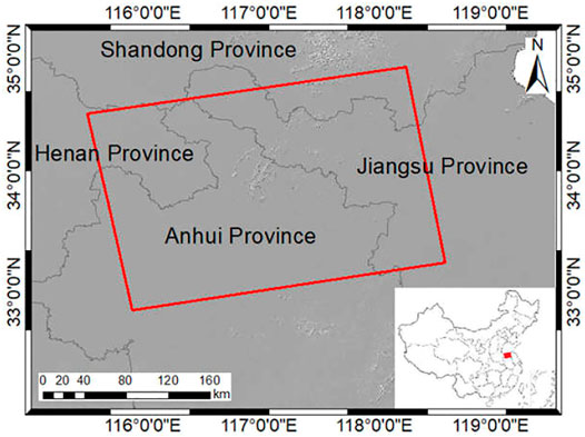
FIGURE 1. Location of Huaibei Coalfield. It covers an area of about 9,600 square kilometers. The area containing coal is about 4,100 square kilometers.
Experimental Data
In order to evaluate the performance of the new phase unwrapping method proposed in this paper, 4 Sentinel-1A SAR data from ESA (European Space Agency) acquired from December 2017 to March 2018 were selected. Two interferometric pairs are constructed by the Sentinel-1A data which are acquired in the IW (interferometric wide) mode, C-band (with 5.6 cm wavelength), VV polarization, and ascending orbit. The Sentinel-1A radar data used in this study has an incident angle of 38.9° and a pixel size of about 2.33*13.90 m. The detail characteristics of the interferometric pairs are shown in Table 1.
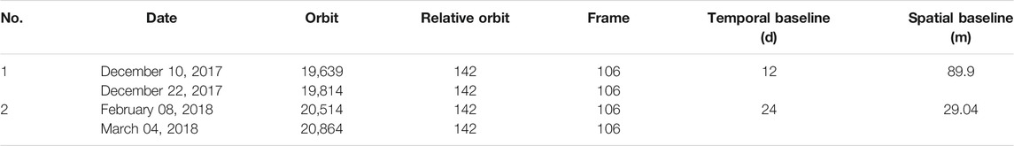
TABLE 1. The two interferometric pairs are used for the test. They contain 4 Sentinel-1A images.
Moreover, the SRTM (Shuttle Radar Topography Mission) DEM (digital elevation model) released by NASA (National Aeronautics and Space Administration) was applied to D-InSAR data processing in this study. The spatial resolution of DEM used in this study is about 90 m.
The data processing flow of InSAR can be referenced in (Massonnet and Feigl, 1998; Hanssen, 2001). The interferometric pairs were processed by D-InSAR (differential radar interferometry) and two interferograms of the whole area were obtained. The subsidence of the mining area will form a series of circular or elliptical interferometric fringes on the InSAR interferogram. Therefore, the subsidence basin is the object of our phase unwinding research to obtain the accurate land subsidence in the coal mining area. The subsidence basin is defined as the position where the subsidence is about 1 cm. The subsidence basins in study area were obtained by detection model based on HOG (histogram of oriented gradient) feature (Ronneberger et al., 2015) automatically. Then, the interferograms and coherence images including one complete subsidence basin were cut out from the original interferograms. Therefore, there are more than 25 subsidence basins within the coverage of a single Sentinel-1A.
Three subsidence basins with different interferometric quality were selected from interferograms generated by two interferometric pairs for phase unwrapping experiment, as shown in Figure 2. Figure 2A is a subsidence basin with good interferometric quality. It contains two interferometric fringes that resemble elliptical shapes. The interferometric fringe edges are characterized as smooth and continuous, without interruption or confusion, and the coherence is also very high, as shown in Figure 2D. Figure 2B is a subsidence basin with common interferometric quality. It contains approximately four interferometric fringes that resemble elliptical shapes. It is obvious that the interferometric fringes inside are partially interrupted or discontinuous, and the coherence value is poor, as shown in Figure 2E. Figure 2C is a subsidence basin with poor interferometric quality, in which the interferometric fringes are partially confused due to the massive noise. The coherence value is terrible, as shown in Figure 2F.
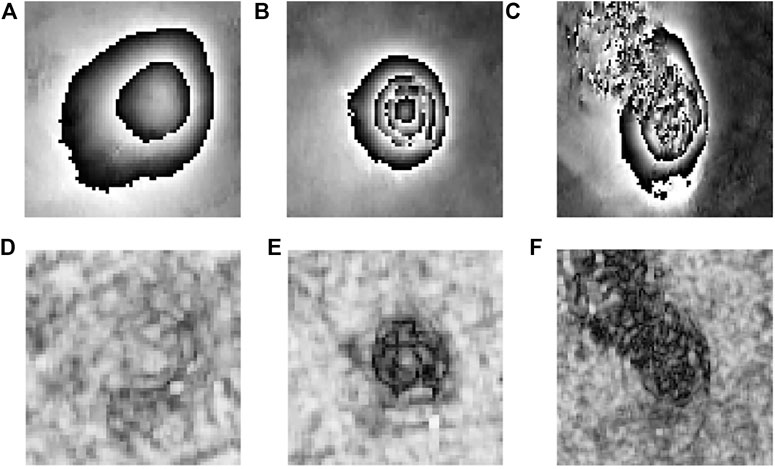
FIGURE 2. Subsidence basins with different interferometric fringes quality are used to verify the reliability of new method. (A) The subsidence basin with clear interferometric fringes. The size of this interferogram is 64*64 pixel; (B) the subsidence basin with discontinuous interferometric fringes. The size of this interferogram is 64*64 pixel; (C) the subsidence basin with partially confused interferometric fringes. The size of this interferogram is 100*100 pixel. (D), (E), and (F) The coherence images corresponding to (A), (B) and (C), respectively.
Methods
The Rules of Phase Unwrapping
After underground coal mining, a series of goaf will be formed (Hu et al., 2013; Yang et al., 2018). In the InSAR interferograms, it is usually manifested as a series of concentric circles or concentric ellipses with similar shapes (Du et al., 2019; Wang et al., 2021). According to the principle of phase unwrapping (Chiglia and Pritt, 1998; Yu et al., 2019), the number of phase-jump (or wrap-count) is calculated by the interferometric fringes of subsidence basin and the phase unwrapping is realized through adding or subtracting 2N in the position corresponded to the interferogram.
The purpose of the edge detection algorithm is to achieve the boundary of subsidence basin in the interferogram. The wrap-count (integer jump of 2π) is determined by number of interferometric fringes. Thus, the phase values of subsidence basins are added or subtracted 2N based on some certain rules. The specific rules of phase unwrapping are that 2N is added to the phase value when there is the change from +π to −π or subtracted in the opposite condition.
In mathematical language, it can be expressed as follows:
where Φ represents the value after phase unwrapping, and φ and N are the wrapping phase and the number of phase-jump, respectively.
Flow Chart of the Novel Method
The swath of SAR image is large, such as Sentinel-1 image with the swath of 250 km, but no land surface deformation occurred in most areas. Only several subsidence basins will be formed in some areas, such as the underground coal mining area. Some factors, such as vegetation growth, surface water, temporal decorrelation, and spatial decorrelation (Zhou et al., 2009; Ronneberger et al., 2015), will bring a lot of phase noise into interferograms, which will result in great difference among interferograms in the mined-out area. For example, some interferometric fringes are clear and continuous, but some are partially interrupted or discontinuous. Moreover, some fringes are even indistinct or confused. Above on these problems, we will not obtain the correct results of phase unwrapping using the traditional phase unwrapping methods, which leads to unreliable monitoring results of land subsidence in the mining area.
To solve this problem, a novel phase unwrapping method based on U-Net convolutional neural network is proposed. Firstly, the U-Net convolutional neural network that has been trained according to some samples is used to extract the edge of the fringes. Then, it can automatically obtain the boundary information of the interferometric fringes in the region of subsidence basin. Secondly, an edge-linking algorithm is constructed based on edge growth and predictive search to connect the break of interferometric fringe automatically. Then, a complete and continuous edge of interferometric fringe is obtained. Finally, according to the rules of phase unwrapping, the number of phase-jump N or the wrap-count is calculated and the phase unwrapping is realized through adding or subtracting 2N at the corresponding position in the interferogram. The flow chart of the novel method is shown in Figure 3.
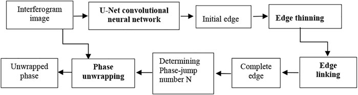
FIGURE 3. Flow chart of the new method of phase unwrapping based on U-Net convolutional neural network used for monitoring the land subsidence in coal mining area.
Extracting the Edge of Interferometric Fringes
The phases of interferogram are wrapped (Hanssen, 2001; Wang et al., 2021). If the position of phase jump (that is wrap-count) in the interferometric fringe can be obtained, the true phase can be obtained. Therefore, the phase unwrapping can be turned into an image segmentation problem to a certain extent. For image edge extraction, many methods have been proposed. Although the FCN (fully convolutional network) can identify the spatial relationship between pixels and realize the segmentation at the semantic level, the process of restoring the image is relatively simple and the obtained fringe boundary is not accurate enough (Jonatnan et al., 2014; Liang et al., 2020). As for InSAR interferometric images, there are not a large amount of training data available for public use, so we can only collect and generate them by ourselves, and the number of samples generated is generally small. Due to the practicality of U-Net convolutional neural network and its learning ability with fewer samples (Ronneberger et al., 2015; Parente et al., 2019), the U-Net convolutional neural network is used to obtain the edge information (or the wrap-count at each pixel) of the interferometric fringes automatically, which is the first step of the new phase unwrapping method. The main role of U-Net convolutional neural network in new phase unwrapping method is to obtain the wrap-count (integer jump of 2π) at each pixel by edge detection.
The U-Net convolutional neural network is basically same as the FCN. Through multiple convolutions and pooling operations, the feature dimensions are improved and the images are compressed (Kando et al., 2019; Esch et al., 2020). In the process of image restoration, the U-Net convolutional neural network also convolved the fused images for many times (Qin et al., 2020), which enhanced the detailed information of images and achieved the better segmentation effect.
The training sample set of U-Net convolutional neural network came from 21 interferometric pairs composed of Sentinel-1A data corresponding to Huaibei Coalfield and Yanzhou Coalfield in China. A total of 150 training samples have been established and these samples have been uniformly resampled to 256 × 256×1. For the convolutional neural network, the number of samples is little. However, the U-Net convolutional neural network has a good generalization ability. This can compensate for shortage of samples to a certain extent.
Edge Thinning and Edge Linking
As there are lots of surface vegetation and farmlands in the mining area, it will cause incoherence phenomena in monitoring the land subsidence by InSAR technology, which results in some discontinuous or interrupted interferometric fringes in the interferogram. Thus, it is impossible to extract the continuous and complete fringe boundary directly. Although the U-Net convolutional neural network can extract relatively clear interferometric fringe boundary, the edge thinning and edge linking are needed to carry out to obtain the closed and complete edge, especially in case of discontinuous, interrupted, or even confused interferometric fringes.
Edge Thinning
An improved algorithm is adopted for edge thinning (Xu et al., 2014), which is described as follows:
Step 1: the edge points in the image are traversed and the current edge point is recorded as P0
Step 2: the edge points in the eight-connected domain centered on P0 are counted as E(P0). If E(P0) = 0, this edge point is eliminated
Step 3: if 2 < E(P0)<6, and S(P0) = 1, it is marked as the point to be eliminated, and it is eliminated after the traversal is complete. S(P0) is the point that is based on P1, P2, P8 to sort., which is the number of changes from the edge point to the non-edge point.
The above three steps constitute a traversal and carry out as repeated iteration until that no points satisfy the rule to be marked.
Edge Linking
In order to obtain the complete edge of the interferometric fringes, an edge linking operation is required. Based on edge growth and predictive search, a new algorithm is constructed by improving the edge growth method (Farag and Delp, 1995; Lin and Shi, 2000). The specific steps are as follows:
Step 1: search the endpoint P in the edge graph
Step 2: five edge points are searched in the reverse from the endpoint and the direction of the edge is determined by the coordinates of these edge points
Step 3: according to the edge trend determined in the previous step, the range of the edge growth is limited. The edge growth is carried out according to the gradient of the original image to obtain the new endpoint P′
Step 4: with the new endpoint P′ as the starting point, the edge growth continues until it connects to another endpoint.
The operation of edge thinning and edge linking is based on binary images. So, before the edge thinning and linking, the threshold segmentation of edge image is carried out to obtain the binary image of the result from the U-Net convolutional neural network.
Results
In order to evaluate the performance of the new method, some interferograms including the whole mining subsidence basins obtained by Sentinel-1A data were used.
Model Training
Neural networks have been applied to InSAR phase unwrapping (Jonathan et al., 2015; Parente et al., 2019; Kando et al., 2019; Sica et al., 2020). As an important branch of machine learning, neural networks should be trained with sample data before edge extraction (Lin and Shi, 2000). Firstly, 60 targets of subsidence basins were extracted by HOG (histogram of oriented gradient) model (Wang et al., 2021) and their edge images were obtained to form the basic training samples. Secondly, in order to obtain more samples, the basic samples were uniformly resampled to 256 × 256 pixels by the resampling method of bilinear interpolation. Then, other 90 subsidence basins and corresponding edge images were achieved through transformation of rotation, translation, and zoom for the basic samples. Finally, a total of 150 training samples were obtained and some samples are shown as Figure 4. In the model established in this paper, the training group consists of 150 pairs of images, the test group consists of 10 images, and the validation group consists of 5 images.
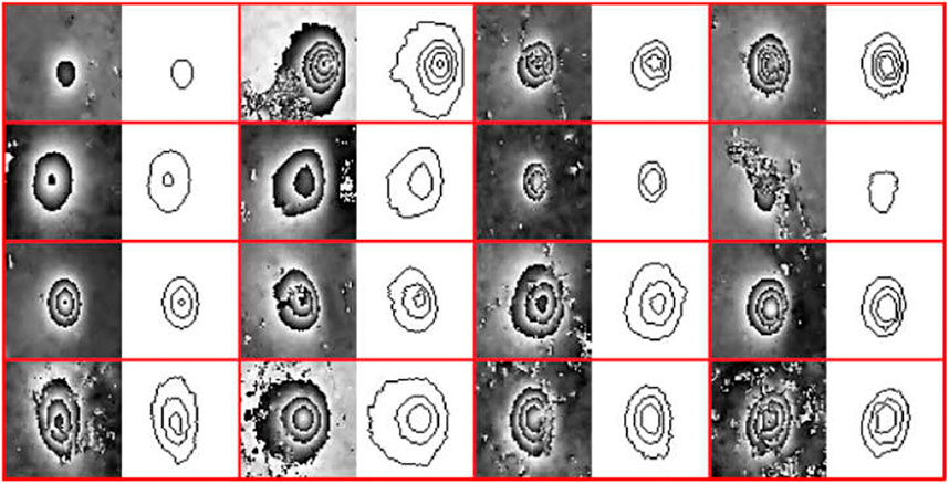
FIGURE 4. Some training samples are used for the U-Net convolutional neural network model in this paper. A total of 150 samples are used for model training. Interferograms and extracted fringe edges are alternately presented in different columns.
The loss function is used to evaluate the difference between predicted and real values in the training process of neural network. The purpose of training or optimization operation is to minimize the loss function (Parente et al., 2019; Esch et al., 2020). The smaller the loss function value is, the closer the predicted value of the model is to the real value, and the result will be more accurate. The essence of edge extraction is a binary classification, so the binary cross entropy function is used as the loss function of U-Net convolutional neural network to represent the model accuracy. The overfitting problem is avoided by using the dropout function before and after the last convolutional layer and discarding some parameters randomly.
In order to further evaluate the performance of the new method quantitatively, the mean phase difference (M) and mean square error (MSE) are selected as assessment indexes to compare the results of new method with those of other methods quantitatively. The expressions are as follows:
where m and n are the number of columns and rows of the image; I and K represent the phase unwrapping result of new method proposed in this paper and other methods, respectively. (i,j) represents the position of the pixel.
Phase Unwrapping for the Clear Interferometric Fringes
A subsidence basin with clear interferometric fringes from real interferometric data was selected to evaluate the performance of the new method. As shown in Figure 2A, the subsidence basin had good interferometric quality which is characterized with smooth and continuous interferometric fringe edges, and the coherence value is also very high in the coherence image. The results of edge thinning and linking after binarization process are shown in Figure 5 and the result of phase unwrapping is shown in Figure 6A. In order to verity the effectiveness of the new method proposed in this paper, the results are compared with other phase unwrapping methods, such as minimum cost flow (MCF) method, Goldstein’s branch-cut method, quality-guided phase unwrapping (QG) method, Flynn’s minimum discontinuity (MD) method, LP minimum norm method (LP), and so on. Goldstein’s branch-cut (Goldstein) algorithm (Yu et al., 2019) is the most representative of the residue-theorem-based methods, connecting the nearby positive and negative residues so that the residues are balanced. The minimum cost flow (MCF) PU method (Costantini, 1998; Liu and Pan, 2020) and Flynn’s minimum discontinuity (MD) method (Xu et al., 2016) can be classified as the LP-norm phase unwrapping method. Quality-guided (QD) phase unwrapping method assumes that pixels with high quality are less likely to cause PU error (Yu et al., 2019). The methods always attempt to first make the integration path that visits the highest-quality pixel provided by the quality map. The specific results are shown as Figures 6B–F. The quantitative comparisons are shown in Table 2.
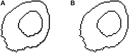
FIGURE 5. The edges are extracted based on U-Net convolutional neural network in the case of clear interferometric fringes. (A) The initial edge using U-Net convolutional neural network. (B) The final edge after edge thinning and edge linking.
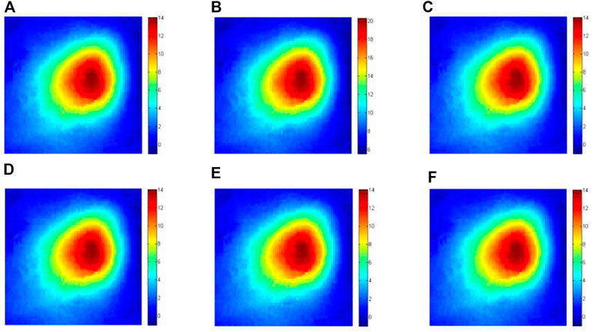
FIGURE 6. Phase unwrapping of InSAR based on U-Net convolutional neural network in the case of clear interferometric fringes. (A) Result of phase unwrapping based on the new method; (B) result of phase unwrapping based on the minimum cost flow (MCF) method; (C) result of phase unwrapping based on the Goldstein method; (D) result of phase unwrapping based on the Minimum discontinuity (MD) method; (E) result of phase unwrapping based on the quality-guided (QG) method; (F) result of phase unwrapping based on the LP minimum norm (LP) method.
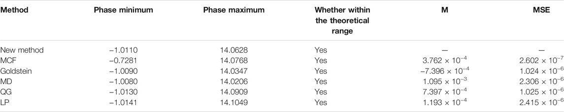
TABLE 2. The quantitative comparison of unwrapping phase between different methods is counted in the case of clear interferometric fringes.
It can be seen from Figure 6 and Table 2 that the result of new method proposed in this paper is generally consistent with those of other methods under the condition of clear interferometric fringes. The ranges of unwrapping phases from different methods are within the theoretical ranges. The values of M and MSE from different methods are all small. The results of unwrapping are highly consistent in images and values. In other words, in the case of clear interferometric fringes from real interferometric data, different phase unwrapping methods can achieve correct unwrapping. It also indicates that the new method can achieve correct phase unwrapping result in the case of clear interferometric fringes.
Discussion
According to the experiments, the result of the new method proposed in this paper is generally consistent with those obtained by other methods in the case of clear interferometric fringes from real interferometric data. All these methods can achieve the correct unwrapping phase of the interferogram. The unwrapping results are different obviously, however, when the interferometric fringes are interrupted or confused. The subsidence basin caused by underground coal mining in the mining area should show a series of concentric circles or concentric ellipses with similar shapes on the InSAR interferogram. There are one or more interferometric fringes according to the different land subsidence. Ideally, the interferometric fringes are continuous. But affected by noise or other reasons, there will be a gap of 2-3 pixels in the one interferometric fringe in some area. But the boundary of the interferometric fringe can still be clearly defined. This is called “interrupted interferometric fringe.” If the noise is larger or the ground subsidence in the mining area exceeds the maximum deformation gradient, it is not easy to distinguish the boundary of two or more interferometric fringes in the InSAR interferogram, and confusion occurs locally or globally. This is called “confused interferometric fringe.” The phase unwrapping results obtained by different methods under the two conditions are particularly discussed.
In the Case of Interrupted Interferometric Fringes
A subsidence basin with interrupted interferometric fringes from real interferometric data, as shown in Figure 2B, was selected to study. The interferometric quality of this subsidence basin is common, and the interferometric fringes inside are partially interrupted and discontinuous. Especially, the coherence value is poor, as shown in Figure 2E. The results of edge extraction and phase unwrapping obtained by the new method proposed in this paper are displayed in Figure 7 and Figure 8A, respectively. Moreover, in order to compare with other five methods, the subsidence basin is resolved by other methods, and the phase unwrapping results are displayed in Figures 8B–F. The quantitative comparison is shown in Table 3.
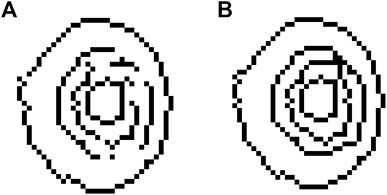
FIGURE 7. Edge extraction results in the case of interferometric fringes discontinuity. (A) The initial edge using U-Net convolutional neural network. (B) The final edge after edge thinning and edge linking.
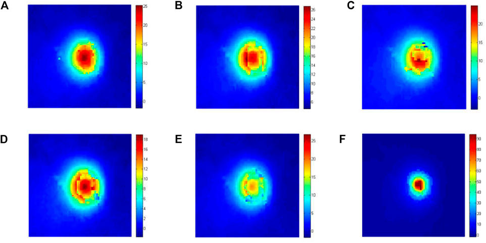
FIGURE 8. Comparison of phase unwrapping results in the case of discontinuous interferometric fringes. (A) Result of phase unwrapping based on the new method; (B), (C), (D), (E), and (F) the result of phase unwrapping based on MCF, Goldstein, MD, QG, and LP methods, respectively.
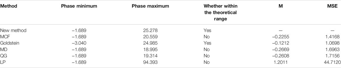
TABLE 3. The quantitative comparison of unwrapping phase between different methods is counted in the case of discontinuous interferometric fringes.
As shown in Figure 8, the result of new method proposed in this paper is obviously different between those of other five methods in the case of discontinuous interferometric fringes. The unwrapping result of new method in this paper is closer with that of Goldstein method than others. The results from MCF, QG, and LP minimum norm methods all have the regions which are not completely unwrapped, but the sizes of the regions are different. From the results of phase unwrapping, the result of new method in this paper is great and without any incompletely unwrapped regions. The detailed comparisons are shown in Table 3. Only the results of new method and Goldstein method are in the theoretical ranges. From the assessment indexes of M and MSE of different methods, the result obtained by LP minimum norm method is the worst among these methods, which had many incompletely unwrapped regions. The results of other four methods also have some obvious regions that are incompletely unwrapped, though the difference is small in M and MSE when compared with the method proposed in this study.
In the Case of Confused Interferometric Fringes
In order to validate the reliability of the method under the influence of extreme noise, a subsidence basin with confused interferometric fringes from real interferometric data is selected for the experiment. As shown in Figure 2C, the quality of the interferometric fringe of the subsidence basin is poor and the fringe is confused due to a large amount of noise. Especially, the coherence value is very poor, as shown in Figure 2F. The edge extraction results are displayed in Figure 9 and the phase unwrapping result is shown in Figure 10A. Moreover, in order to compare with other five methods, the subsidence basin is resolved by other methods and the phase unwrapping results are displayed in Figures 10B–F. The quantitative comparisons are shown in Table 4.
FIGURE 9. Edge extraction results in the case of partially confused interferometric fringes. (A) The initial edge using U-Net convolutional neural network. (B) The final edge after edge thinning and edge linking.
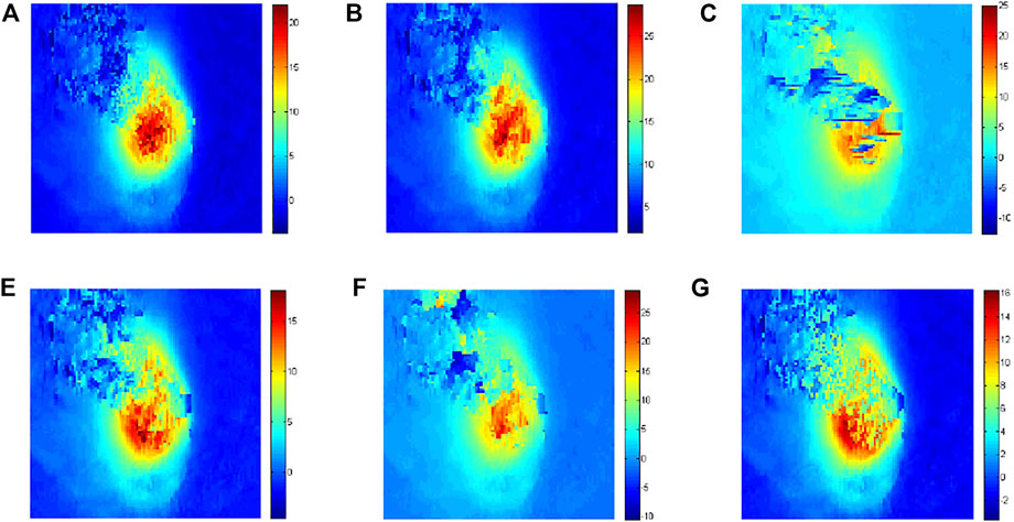
FIGURE 10. Comparison of phase unwrapping results in the case of partially confused interferometric fringes. (A) Result of phase unwrapping based on the new method; (B), (C), (D), (E), and (F) the result of phase unwrapping based on MCF, Goldstein, MD, QG, and LP methods, respectively.
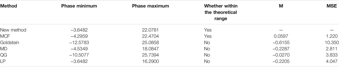
TABLE 4. The quantitative comparison of unwrapping phase between different methods is counted in the case of partially confused interferometric fringes.
It can be seen from Figure 10 and Table 4 that the phase unwrapping result of the method proposed in this paper is relatively consistent with that of the MCF method in the case of confused interferometric fringes. In addition, two phase unwrapping results from the new method and MCF method are also within the theoretical ranges. Therefore, it can be considered that the phase unwrapping results of these two methods are correct. However, in terms of the results of Goldstein method and other four phase unwrapping methods, all of them have the regions that are not unwrapped correctly and they are not within the theoretical ranges. Moreover, there are many unwrapped pixels existing in the phase unwrapping results of Goldstein method and QG method, and the whole effect of the phase unwrapping is not good. Especially, the MSE of the result of Goldstein method is larger than others. Hence, under the condition of extreme noise, the result obtained by the new method proposed in this paper is better than others and it can greatly achieve the correct phase unwrapping results in the case of confused interferometric fringes of mining area.
Conclusion
When monitoring the mining subsidence using radar interferometry, the reliable method of phase unwrapping is the key to obtain subsidence values. It is difficult to correctly resolve the condition where the interferometric fringes are discontinuous or partially confused by using existing methods. In order to solve the problem, a novel method based on the edge extraction using U-Net convolutional neural network was proposed. The method can extract the edge of interferometric fringes and connect discontinuous fringes automatically to obtain the wrap-count at each pixel by edge detection. Finally, the phase results of mining subsidence basins are obtained according to the rules of phase unwrapping and the wrap-count (integer jump of 2π) at each pixel by edge detection. Three kinds of subsidence basins with different interferometric fringes were selected for experiment. The results showed that the method proposed in this paper can obtain more accurate phase unwrapping results under the conditions of clear, interrupted, or partially confused interferometric fringes by compared with other methods. Hence, the greatly reliable results of mining subsidence are achieved.
Through the study in this paper, some important conclusions can be drawn as follows:
1) In the case of clear and uninterrupted interferometric fringes, the results obtained by the new method proposed in this paper are consistent with those obtained by the MCF method, Goldstein method, and other methods. In other words, different methods can obtain correct results of phase unwrapping in the ideal case.
2) The discontinuous boundary of interferometric fringe can be detected and linked by using the new method proposed in this paper automatically, and the complete interferometric fringe edge is obtained in further. The phase unwrapping results of new method are close to that obtained by Goldstein method. The mean phase difference and mean square error are −0.12 and 1.07, respectively. Overall, the new method in this paper is superior to the other five phase unwrapping methods.
3) In the case of partially confused interferometric fringes, it can also realize the detection and linking in position of interrupted boundary to obtain the complete ones. The results obtained in this study are consistent with those obtained by MCF method. The mean phase difference and mean square error are 0.06 and 1.22, respectively. The results showed that the new method proposed in this paper can completely solve the issues of phase unwrapping under the condition that part fringes are partially confused.
The proposed phase unwrapping method for InSAR technology is suitable to monitor the land subsidence caused by underground mining, especially for a circular or elliptic subsidence basin presented in the interferogram. Based on the existed sample data, the method can accurately resolve the issues of the phase unwrapping of discontinuous or partially confused interferometric fringes by using the U-Net convolutional neural network. It can realize the phase unwrapping of interrupted or even partially confused interferometric fringes, but for the interferometric fringes that are not circular or elliptical, the algorithm cannot be solved well. In the next study, the phase unwrapping method will be improved deeply so that it can be adapted to most InSAR phase unwrapping for monitoring land subsidence to achieve the reliable results.
Data Availability Statement
The original contributions presented in the study are included in the article/Supplementary Material; further inquiries can be directed to the corresponding author.
Author Contributions
ZW proposed the method, wrote the manuscript, designed its structure, and revised the manuscript. LL collected and analyzed the data. YY and JW helped in collecting and analyzing the data. ZL and WL critically revised the manuscript.
Funding
This research was funded by the National Natural Science Foundation of China (No. 41876202) and the Natural Science Foundation of Shandong Province (No. ZR2017MD020). This research was also supported by funding from the Major Science and Technology Innovation Projects of Shandong Province (No. 2019JZZY020103).
Conflict of Interest
Author LL was employed by the company Changzhou Construction Research Institute Group Co., Ltd.
The remaining authors declare that the research was conducted in the absence of any commercial or financial relationships that could be construed as a potential conflict of interest.
Publisher’s Note
All claims expressed in this article are solely those of the authors and do not necessarily represent those of their affiliated organizations, or those of the publisher, the editors, and the reviewers. Any product that may be evaluated in this article, or claim that may be made by its manufacturer, is not guaranteed or endorsed by the publisher.
Acknowledgments
We thank the European Space Agency (ESA) for providing the Sentinel-1A remote sensing data. We thank the NASA (National Aeronautics and Space Administration) for providing the SRTM DEM data. We want to thank the reviewers for their valuable suggestions and comments which improved the quality of the manuscript.
References
Carnec, C., Massonnet, D., and King, C. (1996). Two Examples of the Use of SAR Interferometry on Displacement fields of Small Spatial Extent. Geophys. Res. Lett. 23, 3579–3582. doi:10.1029/96GL03042
Chen, B. Q., Li, Z. H., Yu, C., Fairbarin, D., Kang, J. R., Hu, J. S., et al. (2020a). Three-dimensional Time-Varying Large Surface Displacements in Coal Exploiting Areas Revealed through Integration of SAR Pixel Offset Measurements and Mining Subsidence Model. Remote Sens Environ. 240, 111663. doi:10.1016/j.rse.2020.111663
Chen, B. Q., Mei, H., Li, Z. H., Wang, Z. S., Yu, Y., and Yu, H. (2021). Retrieving Three-Dimensional Large Surface Displacements in Coal Mining Areas by Combining SAR Pixel Offset Measurements with an Improved Mining Subsidence Model. Remote Sens 13, 2072–4292. doi:10.3390/rs13132541
Chen, D. H., Chen, H., Zhang, W., Cao, C., Zhu, K. X., and Yuan, X. Q. (2020b). Characteristics of the Residual Surface Deformation of Multiple Abandoned Mined-Out Areas Based on a Field Investigation and SBAS-InSAR: A Case Study in Jilin, China. Remote Sens 12, 3752. doi:10.3390/rs12223752
Chiglia, D. C., and Pritt, M. D. (1998). Two-dimensional Phase Unwrapping: Theory, Algorithms, and Software. New York, USA: Wiley.
Costantini, M. (1998). A Novel Phase Unwrapping Method Based on Network Programming. IEEE Trans. Geosci. Remote Sens. 36, 813–821. doi:10.1109/36.673674
Dai, Y. W., Ng, A. H., Wang, H., Li, L. Y., Ge, L. L., and Tao, T. Y. (2020). Modeling-Assisted InSAR Phase-Unwrapping Method for Mapping Mine Subsidence. IEEE Geosci. Remote Sens. Lett. 18 (6), 1059–1063. doi:10.1109/LGRS.2020.2991687
Du, S., Mallorqui, J. J., Fan, H. D., and Zheng, M. N. (2020). Improving PSI Processing of Mining Induced Large Deformations with External Models. Remote Sens 12, 3145. doi:10.3390/rs12193145
Du, S., Wang, Y. J., Zheng, M. N., Zhou, D. W., and Xia, Y. P. (2019). Improving PSI Processing of Mining Induced Large Deformations with External ModelsGoaf Locating Based on InSAR and Probability Integration Method. Remote Sens 11, 812. doi:10.3390/rs11070812
Du, Z. Y., Ge, L. L., Li, X. J., Ng, A. H., Lu, Z., and Thenkabail, P. S. (2016). Subsidence Monitoring over the Southern Coalfield, Australia Using Both L-Band and C-Band SAR Time Series Analysis. Remote Sens 8, 543. doi:10.3390/rs8070543
Esch, C., Köhler, J., Gutjahr, K., and Schuh, W-D. (2020). One-Step Three-Dimensional Phase Unwrapping Approach Based on Small Baseline Subset Interferograms. Remote Sens 12, 1473. doi:10.3390/rs12091473
Fan, H.-d., Gu, W., Qin, Y., Xue, J.-q., and Chen, B.-q. (2014). A Model for Extracting Large Deformation Mining Subsidence Using D-INSAR Technique and Probability Integral Method. Trans. Nonferrous Met. Soc. China 24, 1242–1247. doi:10.1016/S1003-6326(14)63185-X
Farag, A., and Delp, J. (1995). Edge Linking by Sequential Search. Pattern Recognit 28, 611–633. doi:10.1016/0031-3203(94)00131-5
Gao, Y. D., Tang, X. M., Li, T., Chen, Q. F., Zhang, X., Li, S. J., et al. (2020). Bayesian Filtering Multi-Baseline Phase Unwrapping Method Based on a Two-Stage Programming Approach. Appl. Sci. 10, 3139. doi:10.3390/app10093139
Hamzah, S., Pearson, J. D., Lisboa, P. J., and Hobson, C. A. (1997). “Phase Unwrapping in 3-D Shape Measurement Using Artificial Neural Networks,” in 1997 Sixth International Conference on Image Processing and Its Applications, Dublin, Ireland, July 14–17, 1997, 680–683. doi:10.1049/cp:1997098
Hanssen, R. F. (2001). Radar Interferometry: Data Interpretation and Error Analysis. Dordrecht, Netherland: Kluwer Academic Publisher.
Hu, Z., Ge, L. L., Li, X. J., Zhang, K., and Zhang, L. (2013). An Underground-Mining Detection System Based on DInSAR. IEEE Trans. Geosci. 51, 615–625. doi:10.1109/TGRS.2012.2202243
Ilieva, M., Polanin, P., Borkowski, A., Gruchlik, P., Smolak, K., Kowalski, A., et al. (2019). Mining Deformation Life Cycle in the Light of InSAR and Deformation Models. Remote Sens 11, 745. doi:10.3390/rs11070745
Jonathan, L., Evan, S., and Trevo, D. (2015). “Fully Convolutional Networks for Semantic Segmentation,” in 2015 IEEE Conference on Computer Vision and Pattern Recognition (CVPR). Boston, MA, USA, June 8–10, 2015, 3431–3440. doi:10.1109/CVPR.2015.7298965
Kando, D., Tomioka, S., Miyamoto, N., and Ueda, R. (2019). Phase Extraction from Single Interferogram Including Closed-Fringe Using Deep Learning. Appl. Sci. 9, 3529. doi:10.3390/app9173529
Li, F. Z., Han, W. Y., and Yang, L. (2020). Deep Convolutional Neural Network-Based Robust Phase Gradient Estimation for Two-Dimensional Phase Unwrapping Using SAR Interferograms. IEEE Trans. Geosci. Remote Sens. 58, 4653–4665. doi:10.1109/TGRS.2020.2965918
Liang, J., Zhang, J. C., Shao, J. B., Song, B. F., Yao, B. L., and Liang, R. G. (2020). Deep Convolutional Neural Network Phase Unwrapping for Fringe Projection 3D Imaging. Sensors 20, 3691. doi:10.3390/s20133691
Lin, T., and Shi, Q. Y. (2000). An Edge Growing Approach for Segmentation of Grey and Color Images. J. Image Graphics 5, 911–915. doi:10.3969/j.issn.1006-8961.2000.11.005
Liu, F., and Pan, B. (2020). A New 3-D Minimum Cost Flow Phase Unwrapping Algorithm Based on Closure Phase. IEEE Trans. Geosci. Remote Sens. 58, 1857–1867. doi:10.1109/tgrs.2019.2949926
Liu, X. B., Xing, X. M., Wen, D. B., Chen, L. F., Yuan, Z. H., Liu, B., et al. (2019). Mining-Induced Time-Series Deformation Investigation Based on SBAS-InSAR Technique: A Case Study of Drilling Water Solution Rock Salt Mine. Sensors 19, 5511. doi:10.3390/s19245511
Luo, X. M., Li, H. T., Dong, Z. L., and Zhu, S. Q. (2020). InSAR Phase Unwrapping Based on Square-Root Cubature Kalman Filter. IEEE J. Sel. Top. Appl. Earth Observ. Remote Sens. PP 1, 1. doi:10.1109/jstars.2020.3015739
Ma, C., Cheng, X. Q., Yang, Y. L., Zhang, X. K., Guo, Z. Z., and Zou, Y. F. (2016). Investigation on Mining Subsidence Based on Multi-Temporal InSAR and Time-Series Analysis of the Small Baseline Subset—Case Study of Working Faces 22201-1/2 in Bu’ertai Mine, Shendong Coalfield, China. Remote Sens 8, 951. doi:10.3390/rs8110951
Malinowska, A. A., Witkowski, T. T., Guzy, A., and Hejmanowski, R. (2018). Mapping Ground Movements Caused by Mining-Induced Earthquakes Using Sentinel-1 TOPS Time Series Interferometry. Eng. Geol. 246, 402–411. doi:10.1016/j.enggeo.2018.10.013
Massonnet, D., and Feigl, K. L. (1998). Radar Interferometry and its Application to Changes in the Earth’s Surface. Rev. Geophys. 36, 8755–1209. doi:10.1029/97RG03139
Ng, A. H., Ge, L. L., Du, Z. Y., Wang, S. R., and Ma, C. (2017). Satellite Radar Interferometry for Monitoring Subsidence Induced by Longwall Mining Activity Using Radarsat-2, Sentinel-1 and ALOS-2 Data. Int. J. Appl. Earth Obs. Geoinf. 61, 92–103. doi:10.1016/j.jag.2017.05.009
Parente, L., Taquary, E., Silva, A. P., Souza, C., and Ferreira, L. (2019). Next Generation Mapping: Combining Deep Learning, Cloud Computing, and Big Remote Sensing Data. Remote Sens 11, 2881. doi:10.3390/rs11232881
Pawel, S., Tomasz, S., Artur, W., and Dawid, M. (2020). Land Surface Subsidence Due to Mining-Induced Tremors in the Upper Silesian Coal Basin (Poland)—Case Study. Remote Sens 12, 3923. doi:10.3390/rs12233923
Pawluszek-Filipiak, K., and Borkowski, A. (2020). Integration of DInSAR and SBAS Techniques to Determine Mining-Related Deformations Using Sentinel-1 Data: The Case Study of Rydułtowy Mine in Poland. Remote Sens 12, 242. doi:10.3390/rs12020242
Qin, X. F., Wu, C. Z., Chang, H., Lu, H., and Zhang, X. D. (2020). Match Feature U-Net: Dynamic Receptive Field Networks for Biomedical Image Segmentation. Symmetry 12, 1230. doi:10.3390/sym12081230
Raucoules, D., Maisons, C., Carnec, C., Mouelic, S. L., King, C., and Hosford, S. (2003). Monitoring of Slow Ground Deformation by ERS Radar Interferometry on the Vauvert Salt Mine (France): Comparison with Ground-Based Measurement. Int. J. Remote Sens. 88, 468–478. doi:10.1016/j.rse.2003.09.005
Ronneberger, O., Fischer, P., and Brox, T. (2015). U-net: Convolutional Networks for Biomedical Image Segmentation. Med. Image Comput. Computer-Assisted Intervention (Miccai) 9531, 234–241. doi:10.1007/978-3-319-24574-4_28
Schwartzkopf, W., Milner, T. E., Ghosh, J., Evans, B. L., and Bovik, A. C. (2000). “Two-dimensional Phase Unwrapping Using Neural Networks,” in 4th IEEE Southwest Symposium on Image Analysis and Interpretation, Austin, TX, April 2–4, 2000, 274–277. doi:10.1109/IAI.2000.839615
Sica, F., Calvanese, F., Scarpa, G., and Rizzoli, P. (2020). A CNN-Based Coherence-Driven Approach for InSAR Phase Unwrapping. IEEE Geosci. Remote Sens. Lett. 13, 2541. doi:10.1109/LGRS.2020.3029565
Spoorthi, G. E., Gorthi, S., and Gorthi, R. K. S. S. (2019). PhaseNet: A Deep Convolutional Neural Network for Two-Dimensional Phase Unwrapping. IEEE Signal. Process. Lett. 26, 54–58. doi:10.1109/LSP.2018.2879184
Sui, L. C., Ma, F., and Chen, N. (2020). Mining Subsidence Prediction by Combining Support Vector Machine Regression and Interferometric Synthetic Aperture Radar Data. ISPRS Int. J. Geo-inf. 9, 390. doi:10.3390/ijgi9060390
Tipper, D. J., Burton, D. R., and Lalor, M. J. (1996). A Neural Network Approach to the Phase Unwrapping Problem in Fringe Analysis. Nondestructive Test. Eval. 12, 391–400. doi:10.1080/10589759608952862
Wang, L. Y., Deng, K. Z., and Zheng, M. N. (2020). Research on Ground Deformation Monitoring Method in Mining Areas Using the Probability Integral Model Fusion D-InSAR, Sub-band InSAR and Offset-Tracking. Int. J. Appl. Earth Obs. Geoinf. 85, 101981. doi:10.1016/j.jag.2019.101981
Wang, Z. Y., Li, L., Wang, J., and Liu, J. (2021). A Method of Detecting the Subsidence basin from InSAR Interferogram in Mining Area Based on HOG Features. J. CHINA U. MIN TECHNO.Journal China Univ. Mining Tech. 50, 404–410. doi:10.13247/j.cnki.jcumt.001264
Wang, Z. Y., Wang, S. C., Sun, Y., and Wang, S. S. (2017). A New Phase Unwrapping Algorithm Based on the GVF-Snake Model of Edge Detection. J. China Univ. Mining Tech. 46, 1394–1401. doi:10.13247/j.cnki.jcumt.000767
Xia, Y. P., and Wang, Y. J. (2020). InSAR- and PIM-Based Inclined Goaf Determination for Illegal Mining Detection. Remote Sens 12, 3884. doi:10.3390/rs12233884
Xia, Y., Wang, Y., Du, S., Liu, X., and Zhou, H. (2018). Integration of D-InSAR and GIS Technology for Identifying Illegal Underground Mining in Yangquan District, Shanxi Province, China. Environ. Earth Sci. 77, 1–19. doi:10.1007/s12665-018-7488-1
Xu, H. K., Qin, Y. Y., and Pan, Y. (2014). Improved Edge Thinning Method. LASER & INFRARED 44, 319–324. doi:10.3969/j.issn.1001-5078.2014.03.22
Xu, J. Y., An, D. X., Huang, X. T., and Yi, P. (2016). An Efficient Minimum-Discontinuity Phase-Unwrapping Method. IEEE Geosci. Remote Sens. Lett. 13, 666–670. doi:10.1109/LGRS.2016.2535159
Yang, Z., Li, Z., Zhu, J., Yi, H., Feng, G., Hu, J., et al. (2018). Locating and Defining Underground Goaf Caused by Coal Mining from Space-Borne SAR Interferometry. Isprs-j. Photogramm. Remote Sens. 135, 112–126. doi:10.1016/j.isprsjprs.2017.11.020
Yu, H. W., Lan, Y., Yuan, Z. H., Xu, J. Y., and Lee, H. (2019). Phase Unwrapping in InSAR : A Review. IEEE Geosci. Remote Sens. Mag. 7, 40–58. doi:10.1109/MGRS.2018.2873644
Zheng, L., Zhu, L., Wang, W., Guo, L., and Chen, B. B. (2020). Land Subsidence Related to Coal Mining in China Revealed by L-Band InSAR Analysis. Int. J. Environ. Res. Public Health 17, 1170. doi:10.3390/ijerph17041170
Zheng, M. N., Deng, K. Z., Fan, H. D., and Du, S. (2018). Monitoring and Analysis of Surface Deformation in Mining Area Based on InSAR and GRACE. Remote Sens 10, 1392. doi:10.3390/rs10091392
Zhou, L. F., Yu, H. W., and Lan, Y. (2020). Deep Convolutional Neural Network-Based Robust Phase Gradient Estimation for Two-Dimensional Phase Unwrapping Using SAR Interferograms. IEEE Trans. Geosci. Remote Sens. 58, 4653–4665. doi:10.1109/tgrs.2020.2965918
Zhou, L., Zhang, D., Wang, J., Huang, Z., and Pan, D. (2013). Mapping Land Subsidence Related to Underground Coal Fires in the Wuda Coalfield (Northern China) Using a Small Stack of ALOS PALSAR Differential Interferograms. Remote Sensing 5, 1152–1176. doi:10.3390/rs5031152
Keywords: InSAR, phase unwrapping, U-Net convolutional neural network, mining subsidence, interferometric fringe
Citation: Wang Z, Li L, Yu Y, Wang J, Li Z and Liu W (2021) A Novel Phase Unwrapping Method Used for Monitoring the Land Subsidence in Coal Mining Area Based on U-Net Convolutional Neural Network. Front. Earth Sci. 9:761653. doi: 10.3389/feart.2021.761653
Received: 20 August 2021; Accepted: 07 October 2021;
Published: 16 November 2021.
Edited by:
Yu Chen, China University of Mining and Technology, ChinaReviewed by:
Sen Du, Universitat Politecnica de Catalunya, SpainHongdong Fan, China University of Mining and Technology, China
Peng Liu, Southern University of Science and Technology, China
Francescopaolo Sica, German Aerospace Center, Germany
Copyright © 2021 Wang, Li, Yu, Wang, Li and Liu. This is an open-access article distributed under the terms of the Creative Commons Attribution License (CC BY). The use, distribution or reproduction in other forums is permitted, provided the original author(s) and the copyright owner(s) are credited and that the original publication in this journal is cited, in accordance with accepted academic practice. No use, distribution or reproduction is permitted which does not comply with these terms.
*Correspondence: Zhiyong Wang, skd994177@sdust.edu.cn