EEA geospatial data catalogue
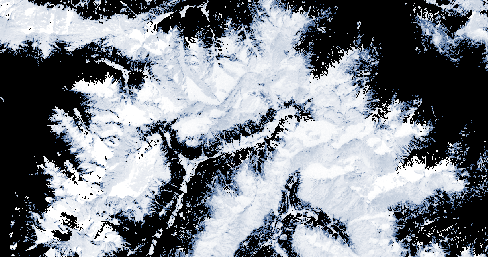
Fractional Snow Cover (raster 20m) 2016-present, Europe, daily, Jul. 2020
The Copernicus Fractional Snow Cover (FSC) product is generated in near real-time for the entire EEA38 and the United Kingdom, based on optical satellite data from the Sentinel-2 constellation. The product provides the fraction of the surface covered by snow at the top of canopy (FSC-TOC) and on ground (FSC-OG) per pixel as a percentage (0% – 100%) with a spatial resolution of 20 m x 20 m.
FSC is one of the products of the pan-European High-Resolution Snow & Ice service (HR-S&I), which are provided at high spatial resolution (20 m x 20 m and 60 m x 60 m), from the Sentinel-2 and Sentinel-1 constellations data from September 1, 2016 onwards.
The FSC product is distributed in raster files covering an area of 110 km by 110 km with a pixel size of 20 m by 20 m in UTM/WGS84 projection, which corresponds to the Sentinel-2 input L1C product tile. Each product is composed of seven separate files corresponding to the different layers of the product, and another metadata file.
You can read more about the FSC product here: https://land.copernicus.eu/en/products/snow/fractional-snow-cover .
Simple
- Date (Creation)
- 2020-07-07
- Date (Publication)
- 2020-07-07
- Edition
-
01.00
- Citation identifier
- copernicus_r_utm-wgs84_20_m_hrsi-fsc_p_2016-now_v01_r00
- Citation identifier
- DAT-244-en
- Point of contact
-
Organisation name Individual name Electronic mail address Website Role European Environment Agency
https://land.copernicus.eu Distributor European Environment Agency
https://land.copernicus.eu Custodian European Environment Agency
https://land.copernicus.eu Point of contact
Point of contact
- Maintenance and update frequency
- Continual
-
GEMET - INSPIRE themes, version 1.0
-
-
Land cover
-
- Keywords
-
-
Continents, countries, sea regions of the world.
-
-
EEA38 (from 2020)
-
United Kingdom
-
- Keywords
-
-
GEMET
-
-
ice
-
monitoring
-
snow
-
land cover
-
climate change impact
-
landscape alteration
-
-
EEA topics
-
-
Land use
-
-
Temporal resolution
-
-
Five days
-
-
EEA Management Plan
-
-
2020 3.6.7
-
- Access constraints
- Other restrictions
- Other constraints
- no limitations to public access
- Use constraints
- Other restrictions
- Other constraints
-
Access to data is based on a principle of full, open and free access as established by the Copernicus data and information policy Regulation (EU) No 1159/2013 of 12 July 2013. This regulation establishes registration and licensing conditions for GMES/Copernicus users.
Free, full and open access to this data set is made on the conditions that:
1. When distributing or communicating Copernicus dedicated data and Copernicus service information to the public, users shall inform the public of the source of that data and information.
2. Users shall make sure not to convey the impression to the public that the user's activities are officially endorsed by the Union.
3. Where that data or information has been adapted or modified, the user shall clearly state this.
4. The data remain the sole property of the European Union. Any information and data produced in the framework of the action shall be the sole property of the European Union. Any communication and publication by the beneficiary shall acknowledge that the data were produced “with funding by the European Union”.
- Spatial representation type
- Grid
- Distance
- 20 20 m
- Language of dataset
- English
- Character set
- UTF8
- Topic category
-
- Environment
- Imagery base maps earth cover
- Climatology, meteorology, atmosphere
- Begin date
- 2016-09-01
))
- Coordinate reference system identifier
- EPSG:32625
- Coordinate reference system identifier
- EPSG:32626
- Coordinate reference system identifier
- EPSG:32627
- Coordinate reference system identifier
- EPSG:32628
- Coordinate reference system identifier
- EPSG:32629
- Coordinate reference system identifier
- EPSG:32630
- Coordinate reference system identifier
- EPSG:32631
- Coordinate reference system identifier
- EPSG:32632
- Coordinate reference system identifier
- EPSG:32633
- Coordinate reference system identifier
- EPSG:32634
- Coordinate reference system identifier
- EPSG:32635
- Coordinate reference system identifier
- EPSG:32636
- Coordinate reference system identifier
- EPSG:32637
- Coordinate reference system identifier
- EPSG:32638
- Distribution format
-
-
GeoTIFF
(
1.0
)
-
GeoTIFF
(
1.0
)
- OnLine resource
-
Protocol Linkage Name WWW:LINK-1.0-http--link
https://cryo.land.copernicus.eu/finder/ Cryo portal
OGC:WMS
https://cryo.land.copernicus.eu/wms/FSC?service=WMS&request=GetCapabilities&version=1.3.0 WWW:LINK-1.0-http--link
https://cryo.land.copernicus.eu/resto/api/collections/HRSI/search.json REST API
WWW:LINK-1.0-http--link
https://www.wekeo.eu WEKEO portal
WWW:LINK-1.0-http--link
https://land.copernicus.eu/en/technical-library/hrsi-snow-pum/@@download/file Product user manual
WWW:LINK-1.0-http--link
https://land.copernicus.eu/en/technical-library/hrsi-snow-atbd/@@download/file Algorithm theoretical basis document
WWW:LINK-1.0-http--link
https://wekeo-broker.apps.mercator.dpi.wekeo.eu/databroker/ui/ HDA API (Harmonized Data Access (WEkEO)
WWW:LINK-1.0-http--link
https://land.copernicus.eu/en/products/snow/fractional-snow-cover#download Download (requires authentication)
- OnLine resource
-
Protocol Linkage Name DOI
https://doi.org/10.2909/3e2b4b7b-a460-41dd-a373-962d032795f3
- Hierarchy level
- Dataset
Conformance result
- Date (Publication)
- 2010-12-08
- Explanation
-
See the referenced specification
- Statement
-
The validation of algorithm for FSC retrieval is fully described in the Quality Assessment Report:
https://land.copernicus.eu/en/technical-library/hrsi-snow-qar-s2/@@download/file .
Metadata
- File identifier
- 3e2b4b7b-a460-41dd-a373-962d032795f3 XML
- Metadata language
- English
- Character set
- UTF8
- Hierarchy level
- Dataset
- Date stamp
- 2024-02-06T16:45:26.826Z
- Metadata standard name
-
ISO 19115/19139
- Metadata standard version
-
1.0
- Metadata author
-
Organisation name Individual name Electronic mail address Website Role European Environment Agency
Point of contact