EEA geospatial data catalogue
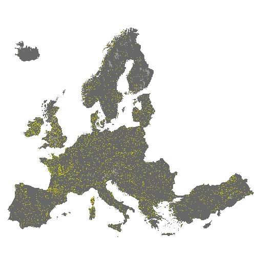
Small Woody Features 2015 (raster 100 m), Europe, 3-yearly - Nov. 2019
The HRL Small Woody Features (SWF) is a new Copernicus Land Monitoring Service (CMLS) product, which provides harmonized information on linear structures such as hedgerows, as well as patches (200 m² ≤ area ≤ 5000 m²) of woody features across the EEA39 countries.
Small woody landscape features are important vectors of biodiversity and provide information on fragmentation of habitats with a direct potential for restoration while also providing a link to hazard protection and green infrastructure, amongst others. The SWF layer contains woody linear, and small patchy elements, but is not differentiated into trees, hedges, bushes and scrub. The spatial pattern are limited to linear structures and isolated patches (patchy structures) on the basis of geometric characteristics. Additional Woody Features (AWF) are also included in this product. They consist of woody structures that do not fulfil the SWF geometric specifications but which are connected to valid SWFs structures. VHR imagery (DEIMOS-2, Pleiades 1A, Pleiades 1B, GeoEye-1, SPOT 6, SPOT 7, WorldView-2, WorldView-3 images from 2015) made available in the ESA Copernicus DWH are the main data source for the detection of small woody features identifiable within the given image resolution.
The dataset is available for the 2015 reference year and is produced in three different formats. This metadata corresponds to the SWF 100m spatial resolution raster aggregate layers: SWF density (0 – 100 %), AWF density (0 – 100 %) and SWF+AWF density (0 – 100 %). The SWF 100m raster layer, consistent with the EEA 100m grid, is a 100m aggregated version of the SWF 5m raster layer. It can be used as a landscape descriptor of SWF density for large areas.
You can read more about the product here: https://land.copernicus.eu/en/products/high-resolution-layer-small-woody-features/small-woody-features-20 15.
Simple
- Date (Creation)
- 2019-11-06
- Date (Publication)
- 2019-11-06
- Date (Revision)
- 2020-03-04
- Edition
-
01.00
- Citation identifier
- copernicus_r_3035_100_m_swf-2015_p_2014-2016_v01_r00
- Citation identifier
- DAT-237-en
- Point of contact
-
Organisation name Individual name Electronic mail address Website Role European Environment Agency
https://land.copernicus.eu Distributor European Environment Agency
https://land.copernicus.eu Custodian European Environment Agency
https://land.copernicus.eu Point of contact
Point of contact
- Maintenance and update frequency
- Continual
-
GEMET - INSPIRE themes, version 1.0
-
-
Land cover
-
- Keywords
-
-
Continents, countries, sea regions of the world.
-
-
EEA39
-
- Keywords
-
-
GEMET
-
-
soil surface sealing
-
land cover
-
urban area
-
land use
-
built environment
-
sealing
-
landscape alteration
-
-
EEA Management Plan
-
-
2020 3.6.7
-
-
EEA topics
-
-
Biodiversity
-
Agriculture and food
-
Land use
-
- Access constraints
- Other restrictions
- Other constraints
- no limitations to public access
- Use constraints
- Other restrictions
- Other constraints
-
Access to data is based on a principle of full, open and free access as established by the Copernicus data and information policy Regulation (EU) No 1159/2013 of 12 July 2013. This regulation establishes registration and licensing conditions for GMES/Copernicus users.
Free, full and open access to this data set is made on the conditions that:
1. When distributing or communicating Copernicus dedicated data and Copernicus service information to the public, users shall inform the public of the source of that data and information.
2. Users shall make sure not to convey the impression to the public that the user's activities are officially endorsed by the Union.
3. Where that data or information has been adapted or modified, the user shall clearly state this.
4. The data remain the sole property of the European Union. Any information and data produced in the framework of the action shall be the sole property of the European Union. Any communication and publication by the beneficiary shall acknowledge that the data were produced “with funding by the European Union”.
- Spatial representation type
- Grid
- Distance
- 100 m
- Language of dataset
- English
- Character set
- UTF8
- Topic category
-
- Environment
- Imagery base maps earth cover
- Begin date
- 2014-01-01
- End date
- 2016-12-31
))
- Coordinate reference system identifier
- EPSG:3035
- Distribution format
-
-
GeoTIFF
(
1.0
)
-
GeoTIFF
(
1.0
)
- OnLine resource
-
Protocol Linkage Name OGC:WMS
https://image.discomap.eea.europa.eu/arcgis/services/DownloadLayers/HRL_SWF_2015_DL/MapServer/WMSServer?service=WMS&request=GetCapabilities&version=1.3.0 0
ESRI:REST
https://image.discomap.eea.europa.eu/arcgis/rest/services/DownloadLayers/HRL_SWF_2015_DL/MapServer/ WWW:LINK-1.0-http--link
https://land.copernicus.eu/en/products/high-resolution-layer-small-woody-features/small-woody-features-2015#Download Download (requires authentication)
- OnLine resource
-
Protocol Linkage Name DOI
https://doi.org/10.2909/2adfe942-186d-4ee0-af41-b8b864dfb6b6
- Hierarchy level
- Dataset
Conformance result
- Date (Publication)
- 2010-12-08
- Explanation
-
See the referenced specification
- Statement
-
Supervised classification and visual interpretation of linear and patchy features on pan-sharpened VHR_IMAGE_2015. Small woody landscape features are important vectors of biodiversity and provide information on fragmentation of habitats with a direct potential for restoration while also providing a link to hazard protection and green infrastructure, amongst others (code = 1). Besides, the Minimum Mapping Unit (MMU) for small patches of trees is 200 m², while the Maximum Mapping Unit (MaxMU) is defined by 5000 m². The Minimum Mapping Length (MML) of linear elements is 50 m. There is also an other distinction between this two structures: width (30 m maximum for linear instead of 30 m minimum for patchy). Additional Woody Features (code = 3) consist of woody structures that do not fulfil the SWF geometric specifications but which are connected to valid SWFs structures, as well as patchy structures too large to be considered as valid SWF. No data (code = 254). Out of Large Region limits (code = 255). Tiles NO116 (Southeast Norway) and NO119 (Northeast Norway) have been discontinued and will not be published due to lack of availability of suitable satellite data.
Some tiles in the dataset are marked as v. 020. These tiles did first show unsatisfactory results and had to be reprocessed.
Metadata
- File identifier
- 2adfe942-186d-4ee0-af41-b8b864dfb6b6 XML
- Metadata language
- English
- Character set
- UTF8
- Hierarchy level
- Dataset
- Date stamp
- 2024-02-06T16:44:49.538Z
- Metadata standard name
-
ISO 19115/19139
- Metadata standard version
-
1.0
- Metadata author
-
Organisation name Individual name Electronic mail address Website Role European Environment Agency
Point of contact