NOAA/WDS Paleoclimatology - Heyerdahl fire data from Black Bear, central Oregon - IMPD USBEE002
 Paleoclimatology - Fire History
This archived Paleoclimatology Study is available from the NOAA National Centers for Environmental Information (NCEI), under the World Data Service (WDS) for Paleoclimatology. The associated NCEI study type is Fire. The data include parameters of fire history|tree ring with a geographic location of Oregon, United States Of America. The time period coverage is from 547 to -61 in calendar years before present (BP). See metadata information for parameter and study location details. Please cite this study when using the data.
- Cite as: Heyerdahl, E.K.; Falk, D.A.; Loehman, R.A. (2018-03-21): NOAA/WDS Paleoclimatology - Heyerdahl fire data from Black Bear, central Oregon - IMPD USBEE002. [indicate subset used]. NOAA National Centers for Environmental Information. https://doi.org/10.25921/tc7e-w892. Accessed [date].
- Please refer to Credit tab for full citation information.
- doi:10.25921/tc7e-w892
- noaa-fire-23654
- NCEI DSI 1200_02
- NCEI DSI 1200_01
noaa-fire-23654
| Search Data |
|
| Download Data |
|
| Distribution Formats |
|
| Ordering Instructions | Contact NCEI for other distribution options and instructions. |
| Distributor | NOAA National Centers for Environmental Information
ncei.info@noaa.gov |
| Dataset Point of Contact | NOAA National Centers for Environmental Information
ncei.info@noaa.gov |
| Dataset Point of Contact | Data Center Contact
NOAA World Data Service for Paleoclimatology 828-271-4800 paleo@noaa.gov |
| Coverage Description | Date Range: 1403 CE to 2011 CE; Date Range: 547 cal yr BP to -61 cal yr BP; |
| Time Period | 1403 to 2011 |
| Spatial Bounding Box Coordinates |
N: 44.401615
S: 44.401615
E: -119.706649
W: -119.706649
|
| Spatial Coverage Map | |
| General Documentation |
|
| Publication Dates |
|
| Data Presentation Form | Digital table - digital representation of facts or figures systematically displayed, especially in columns
|
| Dataset Progress Status | Complete - production of the data has been completed |
| Data Update Frequency | Data update frequency not available |
| Supplemental Information |
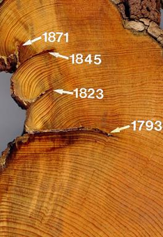
STUDY NOTES: This site was sampled as part of a project to reconstruct historical fire regimes in central Oregon. White fir (Abies concolor) and grand fir (Abies grandis) hybridize in the sampling area and are difficult to identify in the field so we did not attempt to distinguish between these two species, but report them as a combined category. Ring-boundary fire scars were assigned to the preceding calendar year. Several metadata files are provided with the FHX file. -999 in any file indicates no data. https://www.ncei.noaa.gov/pub/data/paleo/firehistory/firescar/northamerica/supplemental/usbee002_plot_data.csv provides information on the plots. https://www.ncei.noaa.gov/pub/data/paleo/firehistory/establishment/northamerica/supplemental/usbee002_recruitment.dat provides information on the trees from which we attempted to remove wood samples (at least 20 cm in diameter at breast height (1.4 m) from which it appeared we could obtain an intact wood sample). https://www.ncei.noaa.gov/pub/data/paleo/firehistory/firescar/northamerica/supplemental/usbee002_saplings.csv provides information on small trees that we did not attempt to remove wood samples from. These trees were tallied in each plot by species and diameter class (measured at breast height, 1.4 m) in 5.6-m radius plots. Diameter classes: 2.5 (0-5 cm), 7.5 (5-10 cm), 15 (10-20 cm). https://www.ncei.noaa.gov/pub/data/paleo/firehistory/firescar/northamerica/supplemental/usbee002_scarred_tree_info.csv provides information on fire-scarred trees, including ones we also sampled for recruitment date. https://www.ncei.noaa.gov/pub/data/paleo/firehistory/firescar/northamerica/supplemental/usbee002_undatable_trees.csv provides information on trees from which it did not appear that we could obtain intact wood samples.
ABSTRACT SUPPLIED BY ORIGINATOR: Records of past fire occurrence from tree rings, charcoal found in lake sediments, and other proxies. Parameter keywords describe what was measured in this data set. Additional summary information can be found in the abstracts of papers listed in the data set citations. Additional information on the International Multiproxy Database (IMPD) data set procedures are also available. |
| Purpose | Records of past fire occurrence from tree rings, charcoal found in lake sediments, and other proxies. Parameter keywords describe what was measured in this dataset. Additional summary information can be found in the abstracts of papers listed in the dataset citations. Additional information on the International Multiproxy Database (IMPD) dataset procedures are also available. |
| Dataset Citation |
|
| Cited Authors |
|
| Originators |
|
| Publishers |
|
| Theme keywords | Global Change Master Directory (GCMD) Science Keywords
|
| Data Center keywords | Global Change Master Directory (GCMD) Data Center Keywords
|
| Place keywords |
|
| Use Constraints |
|
| Access Constraints |
|
| Fees |
|
Last Modified: 2023-10-11
For questions about the information on this page, please email: ncei.info@noaa.gov