NOAA/WDS Paleoclimatology - Saladyga fire data from Tar Run, Northeast Pennsylvania (Schuylkill County) - IMPD USTAR001
This archived Paleoclimatology Study is available from the NOAA National Centers for Environmental Information (NCEI), under the World Data Service (WDS) for Paleoclimatology. The associated NCEI study type is Fire. The data include parameters of fire history|tree ring with a geographic location of Pennsylvania, United States Of America. The time period coverage is from 68 to -67 in calendar years before present (BP). See metadata information for parameter and study location details. Please cite this study when using the data.
- Cite as: Saladyga, T.; Lawrence, N.; Raso, C.; Miller, A. (2019-10-14): NOAA/WDS Paleoclimatology - Saladyga fire data from Tar Run, Northeast Pennsylvania (Schuylkill County) - IMPD USTAR001. [indicate subset used]. NOAA National Centers for Environmental Information. https://doi.org/10.25921/dns9-y690. Accessed [date].
- Please refer to Credit tab for full citation information.
- doi:10.25921/dns9-y690
- noaa-fire-28035
- NCEI DSI 1200_02
- NCEI DSI 1200_01
noaa-fire-28035
| Search Data |
|
| Download Data |
|
| Distribution Formats |
|
| Ordering Instructions | Contact NCEI for other distribution options and instructions. |
| Distributor | NOAA National Centers for Environmental Information
ncei.info@noaa.gov |
| Dataset Point of Contact | NOAA National Centers for Environmental Information
ncei.info@noaa.gov |
| Dataset Point of Contact | Data Center Contact
NOAA World Data Service for Paleoclimatology 828-271-4800 paleo@noaa.gov |
| Coverage Description | Date Range: 1882 CE to 2017 CE; Date Range: 68 cal yr BP to -67 cal yr BP; |
| Time Period | 1882 to 2017 |
| Spatial Bounding Box Coordinates |
N: 40.757176
S: 40.757176
E: -76.240169
W: -76.240169
|
| Spatial Coverage Map | |
| General Documentation |
|
| Associated Resources |
|
| Publication Dates |
|
| Data Presentation Form | Digital table - digital representation of facts or figures systematically displayed, especially in columns
|
| Dataset Progress Status | Complete - production of the data has been completed |
| Data Update Frequency | Data update frequency not available |
| Supplemental Information |
STUDY NOTES: TAR.FHX removed from study title
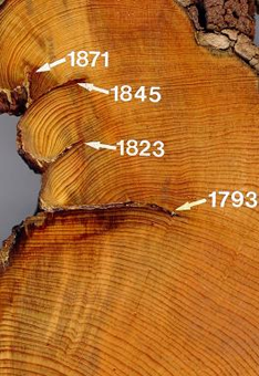
ABSTRACT SUPPLIED BY ORIGINATOR: Placed-based fire management planning that considers historical patterns and processes as well as contemporary local knowledge is recognized as an alternative to broad-scale, regional approaches. In this paper, we used dendrochronology and an online survey to assess historical trends and contemporary perceptions of wildfire, respectively, in the fire-prone anthracite coal region of northeastern Pennsylvania. We developed an annual index of fire occurrence and extent from 216 fire-scarred pitch pine (Pinus rigida) distributed across 9 ridgetop study sites for the period 1900–2016. In addition, we collected survey responses from area residents regarding contemporary perceptions of wildfire hazards and management. Our results show that 20th century wildfire activity was not associated with drought, but closely followed fluctuations in the anthracite coal industry, with increased fire occurrence and extent associated with times of severe job losses. Less extensive wildfire continues to occur frequently, with area residents recognizing the need for fuel management (i.e., prescribed fire) and an increase in resources allocated to wildfire prevention and management as well as trash disposal and recycling programs. Our research represents one example of an integrated approach to informing sustainable fire management that considers the link between historical patterns and contemporary perceptions. |
| Purpose | Records of past fire occurrence from tree rings, charcoal found in lake sediments, and other proxies. Parameter keywords describe what was measured in this dataset. Additional summary information can be found in the abstracts of papers listed in the dataset citations. Additional information on the International Multiproxy Database (IMPD) dataset procedures are also available. |
| Dataset Citation |
|
| Cited Authors |
|
| Originators |
|
| Publishers |
|
| Theme keywords | Global Change Master Directory (GCMD) Science Keywords
|
| Data Center keywords | Global Change Master Directory (GCMD) Data Center Keywords
|
| Place keywords |
|
| Use Constraints |
|
| Access Constraints |
|
| Fees |
|
Last Modified: 2024-01-22
For questions about the information on this page, please email: ncei.info@noaa.gov
