Introduction
Fluvial deposystems are the chief conveyors of sediment from continental sources to marine sinks (Syvitski, 2003). The analysis of source-to-sink systems embodies the critical concept of episodic and inefficient fluvial sediment transport entailing variable periods of storage and remobilization (Fryirs, 2013; Walling, 1983). Long-term (≥106 years) burial in local sediment sinks creates landscape dysconnectivity, thereby delaying, muting, distorting, or impeding the propagation of environmental signals through a sediment routing system (Ben-Israel et al., 2022; Romans et al., 2016; Straub et al., 2020). Thus, appreciating the spatial and temporal scales of fluvial sediment storage and recycling is a precondition for accurately interpreting the sedimentary record.
Fluvial landforms are fundamental indicators of the dynamic response of sedimentary systems to external forcings (Sømme et al., 2009). Floodplains, terraces, channel and valley fills, and abandoned fan lobes reveal the locations, mechanisms, and potential durations of sediment sequestration in a catchment. Differences in avulsion frequency, discharge variability, and channel migration between these landscape elements affect the potential volumes and residence times of stored sediment (Latrubesse, 2015; Romans et al., 2016; Sømme et al., 2009). Rivers regularly erode and remobilize channel and floodplain sediments. Therefore, sediment residence times are variable but generally predictable with regard to probability distributions across floodplains (Ielpi et al., 2023). Alluvial deposits comprising fill terraces have a greater potential for long-term storage because they are detached from active channel processes. Similarly, alluvial fans and fluvial fans have high potential for long-term storage because they are inherently aggradational while active (Abrahami et al., 2018; Carretier et al., 2020; Latrubesse, 2015).
Fluvial fans are distinguished by their larger sizes and lower slopes relative to alluvial fans, as well as the fundamental dominance of fluvial processes, the absence of debris flow deposits, and the presence of floodplain deposits (Latrubesse, 2015; Ventra & Clarke, 2018). The term “megafan” has been applied by many authors to large (>103 km2) fluvial fans, both ancient and modern (Chakraborty & Ghosh, 2010; DeCelles & Cavazza, 1999; Gohain & Parkash, 1990; Leier et al., 2005; Wilkinson et al., 2006).
The Miocene–Pliocene sedimentary succession of the High Plains, USA (Fig. 1) records long-lived, widespread fluvial aggradation within the transfer zone of the Mississippi River catchment (Galloway et al., 2011). As such, it served as a buffering impediment to the transfer of sediment and environmental signals through the Rocky Mountain-Gulf of Mexico source-to-sink system. Sinclair et al. (2018), for example, estimated that certain gravels on the High Plains were stored for ~5 million years enroute to sites of deposition, showing that Rocky Mountain sources were likely decoupled from downstream sediment sinks and that temporary sediment retention was operative at local catchment scales. Neogene fluvial landforms on the High Plains and the ancient dynamic processes associated with such long-term storage and recycling are insufficiently understood relative to their Late Pleistocene and Holocene equivalents. If we further our understanding of these aspects, however, we can more accurately decipher the stratigraphic record of changes in uplift, climate, and catchment evolution.
This paper builds on our recent work (Korus & Joeckel, 2023) documenting ~3100 erosionally inverted fluvial landforms in late Eocene–Pliocene strata on the Great Plains. We reconstruct the dynamics of late Miocene–Pliocene fluvial landforms using evidence from a subset of these fluvial ridges as well as terraces adjacent to the South Platte River in extreme northeastern Colorado and the southern Nebraska Panhandle, USA. We present evidence of a nested series of downstream-propagating, or “telescopic” (Al-Farraj & Harvey, 2005; Bowman, 1978; Colombo et al., 2005; Harvey, 1984, 1987; Mather et al., 2017; Silva et al., 1992; White et al., 1996) fluvial fans coinciding with the incision of the western High Plains. Our reconstruction of this fluvial system compares favorably in scale and morphology with extant megafans elsewhere. These observations explain the close association between incision and aggradation in this succession and provide a mechanism for the long-term storage and recycling of sediment on the Great Plains identified by Sinclair et al. (2018).

Geologic Setting
Rivers were the dominant agents of landscape evolution on the Great Plains from the mid-Miocene to the Pliocene (Diffendal, 1982; Joeckel et al., 2014; Korus & Joeckel, 2023; Smith & Platt, 2023). The Ogallala Group accumulated as a broad, eastward-thinning apron between ~19 and ~5 Ma (Ludvigson et al., 2009; Tedford et al., 2004), attaining thicknesses of more than ~210 m in central Nebraska (Gutentag et al., 1984). It comprises dominantly fluvial deposits interbedded with volumetrically minor lacustrine and eolian deposits (Gustavson & Winkler, 1988; Joeckel et al., 2014; Smith & Platt, 2023). Irregular paleotopography, laterally variable sedimentation patterns, and multiple periods of aggradation and degradation during this period resulted in stratigraphic discontinuities (Ludvigson et al., 2009; Swinehart et al., 1985; Tedford, 2004). Lower Ogallala Group sediments filled a series of paleovalleys atop the sub-Ogallala surface, forming vertically and laterally amalgamated channel bodies ~50 m in thickness and as much as 20 km in width (Korus & Joeckel, 2022; Swinehart et al., 1985). Strata atop these paleovalley fills and atop paleouplands are generally sheet-like, recording alluvial plain deposits (Joeckel et al., 2014) and, to the south, eolian sand sheets and loesses (Gustavson & Winkler, 1988).
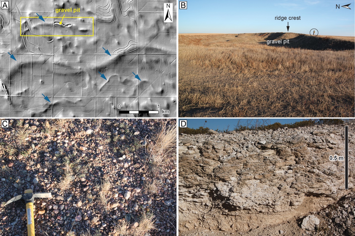
Multiple authors have proposed alluvial fan and fluvial megafan origins for the Ogallala Group, citing vertical grain-size trends (Shepherd & Owens, 1981), subsurface sand-body geometries (Seni, 1980), modern topography and drainage networks (Willett et al., 2018), and the superposition of coarse deposits atop hydromorphic paleosols (Smith et al., 2016) as evidence. Nevertheless, there is strong evidence for deep incision and valley-filling throughout the middle- to late-Miocene succession in parts of western Nebraska and eastern Colorado (Diffendal, 1982; Diffendal et al., 1985; Skinner et al., 1977; Skinner & Johnson, 1984; Tedford, 2004). These unconformities represent widespread landscape degradation, but they commonly exist in close geographic proximity to fluvial channel networks representing rapid aggradation. Korus and Joeckel (2023) discovered numerous and widespread fluvial ridges in the northern High Plains and adjacent areas. Fluvial ridges are elongate, curvilinear, inverted-relief landforms created by differential erosion of coarse channel deposits and intervening fine deposits. Ridges eroded from the upper Ogallala Group and Broadwater Formation are low-relief (<10 m high) features with gentle side slopes, and broad, gravelly tops (Fig. 2). Korus and Joeckel (2023) cite the lack of lateral accretion deposits and the preservation of fluvial channel morphologies in these ridges as evidence for laterally immobile (i.e. fixed) channels, attesting to low bank migration rates, high bank strength, locally high aggradation rates, and dominance of avulsion versus lateral migration. Thus, the ridges are snapshots of channel planforms and drainage patterns at various times throughout the late Miocene–Pliocene.
A major unconformity representing ~1.5 m.y. separates the Ogallala Group from the overlying Broadwater Formation, which records less-widespread, localized fluvial aggradation across a wide (~100 – 150 km) sheet in western and central Nebraska from 3.7 to 2.5 Ma (Duller et al., 2012). These sediments were derived from sources in southeastern Wyoming by the ancestral North Platte River and from sources in northeastern Colorado by the ancestral South Platte River (Swineheart & Diffendal, 1998). Pliocene fluvial deposits exist in the present study area and extend eastward in Nebraska, but discontinuous fluvial ridges and terraces are present as far west as eastern Wyoming (Swinehart & Diffendal, 1997) and the central Colorado Piedmont (Scott, 1982).
The Broadwater Formation contains Rocky Mountain-derived clasts as large as cobbles (Stanley & Wayne, 1972; Swinehart & Diffendal, 1987). The abrupt increase in clast size compared to underlying Miocene deposits and the presence of such clasts hundreds of km from their sources indicates major tectonic or climatic forcing (Sinclair et al., 2018). Duller et al. (2012) used this increase in clast size to calculate a three- to four-fold increase in specific stream power, attributing this to the change from a drier Miocene climate to a wetter Pliocene climate. Differential uplift also affected post-late Miocene deposits on the western Great Plains (McMillan et al., 2002) and the Colorado Piedmont (Leonard, 2002).

Incision dominated the evolution of fluvial systems in the study area after the deposition of the Broadwater Formation. Today’s North Platte and South Platte rivers are incised as much as 400 m below the High Plains surface, as are several other high-order streams on the High Plains.
Considering the evidence for uplift and increasing stream power from the late Miocene to the Pliocene, the abundance of rapidly aggrading deposits in fixed channels begs two questions: (1) What mechanisms were responsible for temporal and spatial variability in aggradation and degradation? (2) What was the nature of sediment storage and recycling?
Materials and Methods
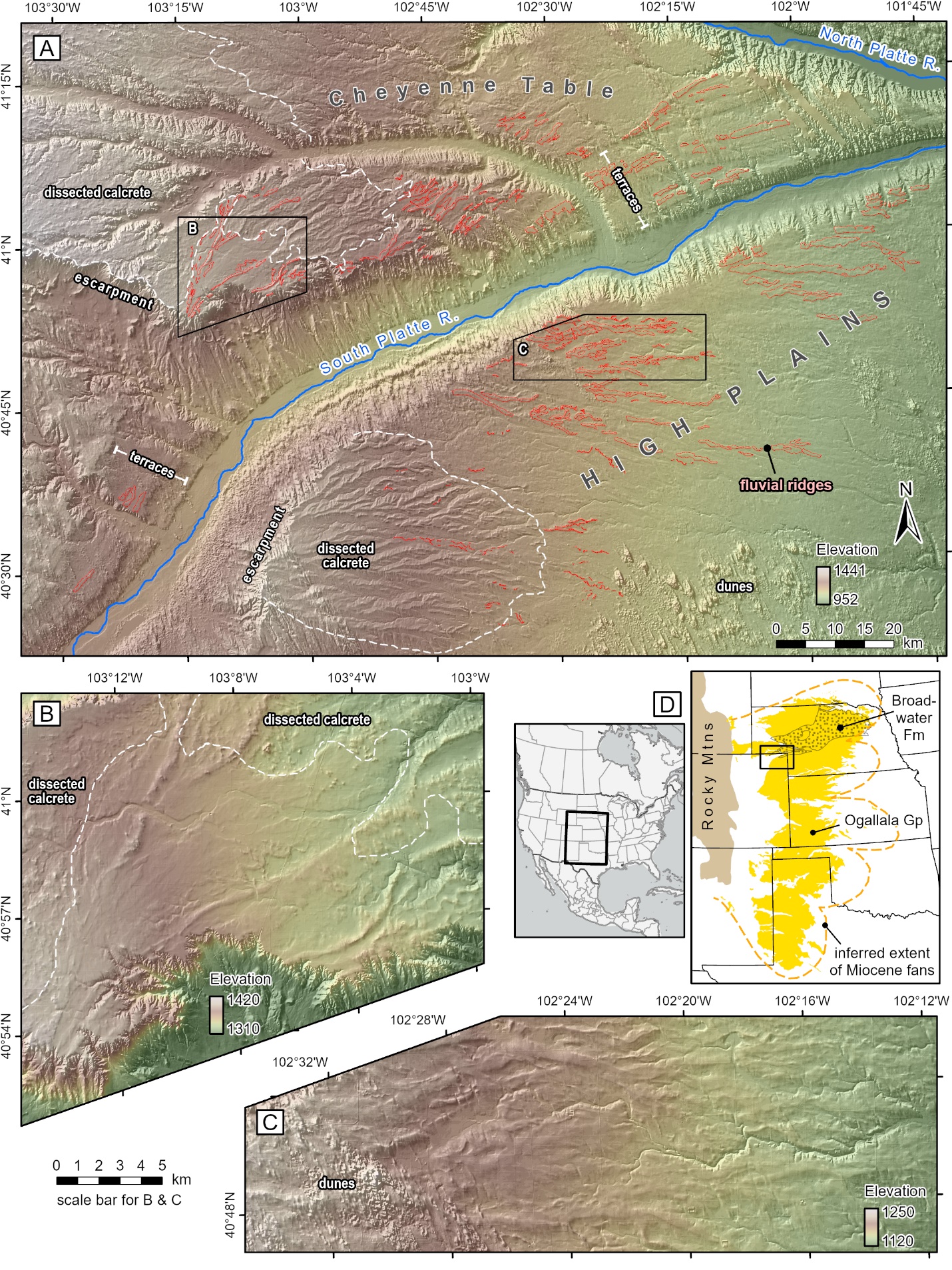
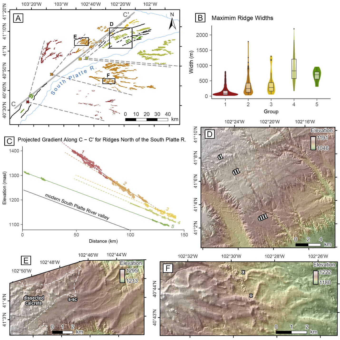
We analyzed hillshaded digital elevation models (DEMs) derived from light detection and ranging (LiDAR) data from the USGS 3D Elevation program (https://www.usgs.gov/3d-elevation-program). We analyzed these data in ArcGIS Pro version 3.1 via a dynamic web service that provides seamless, multi-resolution elevation products from various sources and periods. LiDAR DEMs of one-meter resolution or less were available for the entire study area. Source data were collected in 2015 for the Nebraska Panhandle and in 2018 and 2019 for northeastern Colorado. DEM analyses were supplemented by field observations and spot-checking of soil parent material characteristics from the USDA Web Soil Survey (https://websoilsurvey.nrcs.usda.gov/app/). Fluvial ridges were outlined and the maximum widths of each ridge segment were measured (Table 1). The width of the extant South Platte River was estimated using 10 measurements of the historical channel belt. The longitudinal slopes of the abandoned fan surfaces were calculated using a best-fit line through LiDAR point elevations taken from the centerlines of each fluvial ridge. The longitudinal slope of the South Platte River was measured through a relatively straight, 100 km-long segment within the study area. Fan geometries (apex location, expansion angle, orientation of axis) were estimated using lines drawn parallel to the trends of the ridges on the flanks of each inferred fan (Fig. 3A).
Results
We mapped 544 fluvial ridges within a 9,500 km2 area, including the southern Cheyenne Table, the South Platte Valley, and the High Plains of extreme northeastern Colorado. Overall, these diverging channels form successive, nested, fan-like patterns, ~125 km long and 90 km wide, centered around the WSW–ENE axis of the South Platte Valley. We subdivided the channels into five groups based on their width distributions, longitudinal elevation profiles, locations of inferred apices, and relationships to terraces (Table 1). We do not propose that these longitudinal slopes are ancient depositional slopes; rather, they represent the net result of post-depositional uplift. Also, we find no evidence of post-depositional back-tilting that might have altered these slopes and introduced error in our analysis.
Groups 1 through 3 are late Miocene in age because they are parts of the Ogallala Group (Diffendal, 1982; Tedford, 2004). Group 4 may be latest Miocene or Pliocene, and Group 5 is estimated to be Pliocene in age by analogy to the Remsburg Ranch beds in the nearby North Platte Valley (Swinehart & Diffendal, 1987).
Group 1 (Fig. 3) includes 233 channel segments on plains flanking the north and south sides of the South Platte River valley. The trendlines of the channels define an expansion angle (sensu Blair & McPherson, 1994) of 88° and an axial azimuth of 60°. The inferred apex coincides with a terrace on the north side of the South Platte Valley. The median width is 82 m and the distribution is positively skewed, but all are less than 1000 m (Fig. 3B). These channels are capped by a layer of dissected calcrete (Figs. 1A, 1B). The longitudinal slope is 0.33% (Fig. 3C).
Group 2 includes 216 channel segments on plains flanking the north and south sides of the valley. The expansion angle is 65°, the axial azimuth is 72°, and the inferred apex is located 34 km north-northeast of the Group 1 apex. Median width is 247 m and the distribution is positively skewed (Fig. 3B). A few channels are 1000 to 2000 m in width. Some Group 2 channels are capped by dissected calcrete (Fig. 3E). The longitudinal slope is 0.27% (Fig. 3C).
Group 3 includes 27 channel segments on the Cheyenne Table. Although channels in Group 3 are absent south of the South Platte River, we assume that they have been removed by erosion, so the expansion angle is estimated at 45° and the axial orientation is estimated at 73°. The inferred apex is located 30 km east-northeast of the Group 2 apex. The median width is 282 m and the skewness and range of widths is comparable to that of Group 2 (Fig. 3B). The longitudinal slope is 0.19% (Fig. 3C). A short (5 km) terrace step is present on the northwest edge of these channels, but it tapers out to the northeast where the channels diverge (Fig. 3A, 3D). The channels are bordered on the south by a 25 km-long terrace related to Group 4.
Group 4 includes 53 channel segments flanking the South Platte River. Channel widths are normally distributed, and they have the largest median at 824 m (Fig. 3B). The longitudinal slope is identical to Group 3 at 0.19% (Fig. 3C). The channels north of the river occupy a well-defined terrace 100 m above the present South Platte River (Fig. 3D). Channels south of the river lie on the plains and they are not associated with a terrace. The expansion angle is 44°, the axial orientation is 73°, and the inferred apex lies within the South Platte River valley just 6 km east of the Group 3 apex.
Group 5 includes 15 channels confined to a terrace within the South Platte River valley, approximately 70 m above the present braidplain. A few of the channels and terraces are as far west as the inferred apex of Group 1. The median width of group 5 channels is 698 m and the distribution is slightly negatively skewed (Fig. 3B). The longitudinal slope is 0.16%, which matches the extant slope of the South Platte Valley (Fig. 3C).

Discussion
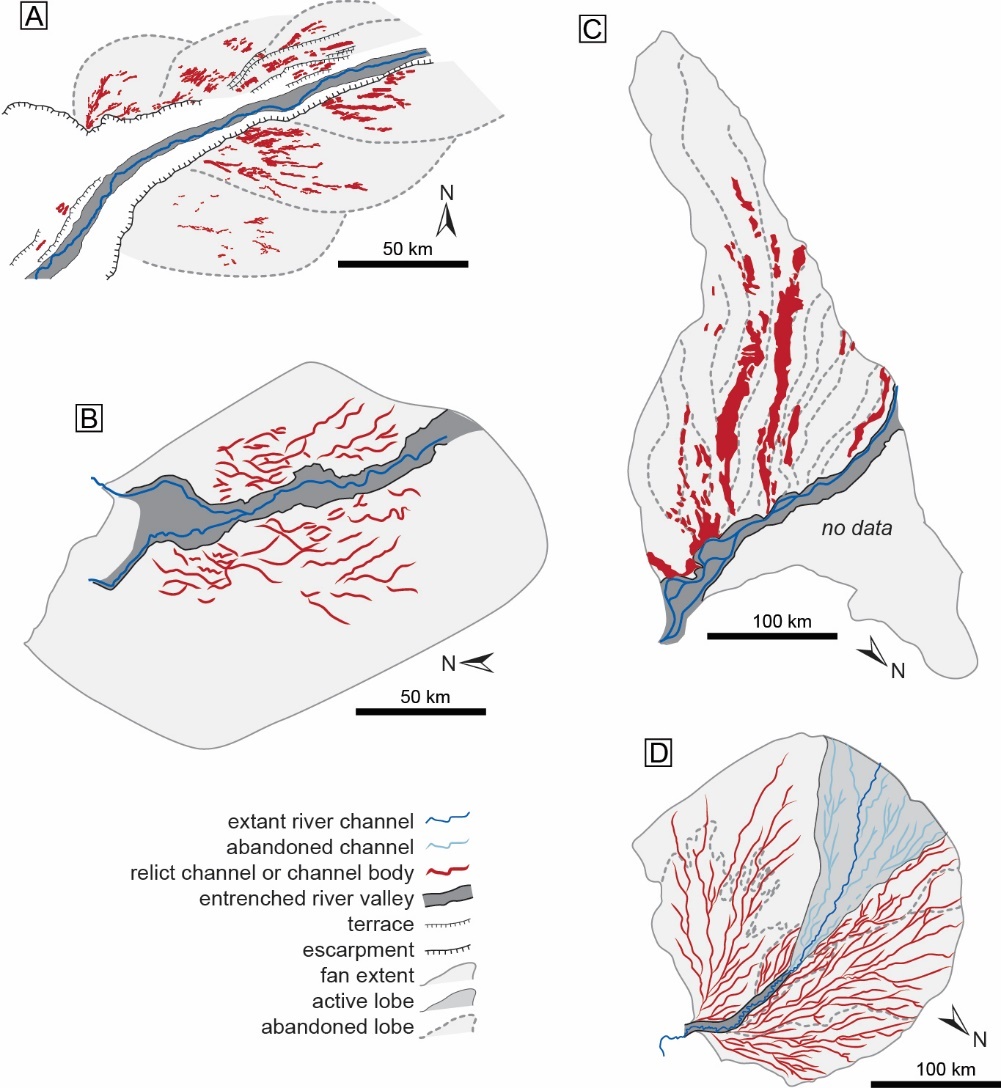
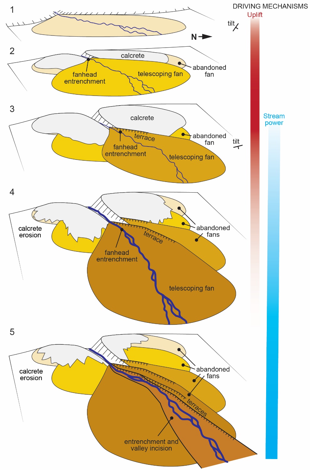
We interpret the mapped channel networks as remnants of a telescopic fluvial fan system because of five critical aspects: (1) radial channel patterns on broad plains without valley walls (Groups 1 – 3 and southern part of Group 4); (2) multiple channel divergences (all Groups); (3) large distance from the Rocky Mountain front (~170 km); (4) downstream-propagating apparent apices; (5) entrenched terraces and channels showing the demise of the megafan. We avoid the application of the term “distributive” for salient reasons. Most modern megafans lack simultaneously active, divergent channels, and thus they are not truly “distributive” systems; rather, the channel divergences that we observe probably represent avulsion nodes (Fielding et al., 2012; North & Warwick, 2007). Additionally, we do not observe a systematic downstream decrease in channel widths as might be expected in distributive channel networks (Weissmann et al., 2010). In the distal part of the fan system, terraces on the north side of the South Platte River appear to be coeval with fan deposits on the south side. This close spatial association of degradational and aggradational landforms strongly suggests that entrenchment and fan deposition were contemporaneous. The youngest channels (Group 5) are confined to the present valley. Thus, they reveal the abandonment of the fan system and initial entrenchment of the modern South Platte Valley.
The process of fan telescoping involves simultaneous fanhead entrenchment and offlap aggradation, resulting in an elongate, multi-part sediment body consisting of proximal inset deposits and distal prograding fan lobes (Mather et al., 2017; Silva et al., 1992). Telescoping has been documented in several Quaternary alluvial fans (e.g. Al-Farraj & Harvey, 2005; Bowman, 1978; Colombo et al., 2005; Harvey, 1984, 1987; Mather et al., 2017; Silva et al., 1992; White et al., 1996). To our knowledge, the existing literature is devoid of studies describing pre-Quaternary telescopic fans. We are also unaware of studies documenting telescopic fluvial fan successions, although fanhead entrenchment and lobe abandonment is known from several Quaternary megafans (Fig. 4). The distinction between alluvial- and fluvial-fan telescoping is important because these depositional landforms have distinct characteristics brought about by fundamentally different processes (Ventra & Clarke, 2018). Alluvial fans have radii of less than a few kilometers, abut their source relief at the outlets of aerially restricted catchments, have higher slopes, and are dominated by deposition from unconfined or poorly confined flows. Fluvial fans have radii of tens to hundreds of kilometers, are separated from their source relief, are fed by rivers draining larger catchments, have lower slopes, and are dominated by deposition in avulsive fluvial systems containing channels and well-developed floodplains. Despite these differences, we show that telescoping is a process that can operate at the scale of megafans >100 km in length. Telescoping can occur across a range of scales and depositional styles, highlighting an important similarity between alluvial and fluvial fans.

Driving mechanisms
There is clear evidence that the study area experienced differential post-Laramide uplift. Steven et al. (1997) and Leonard (2002) argued that paleoflow directions and erosional patterns in the sub-Ogallala unconformity are evidence that the tilt of the Colorado Piedmont and High Plains may have had a northward component since the early or middle Miocene. Leonard (2002) further showed that this pattern of deformation is still expressed in the configuration of the extant Colorado Piedmont. Nevertheless, post-late Miocene uplift had a strong easterly component, causing erosion of the western High Plains and formation of a broad escarpment. McMillan et al. (2002) showed that the extant tilt of the Cheyenne Table—the lone remnant of the late Miocene depositional surface—must be related to uplift because it exceeds that of Miocene depositional slopes calculated from paleohydraulic analysis. Uplift and tilting of the High Plains and Colorado Piedmont have been attributed to dynamic topography (Aslan et al., 2010; Hyndman & Currie, 2011; Karlstrom et al., 2012; Nereson et al., 2013), and, to a lesser extent, denudation-driven isostacy (Aslan et al., 2010; Nereson et al., 2013).
Our results show that the telescopic fluvial fan underwent a rotation from northeasterly (~60°) in Group 1 to east-northeasterly (~73°) in Group 4 (Fig. 3). Moreover, the fan apices migrated in a rotational manner, from northeastward in Groups 1 and 2 to eastward in Groups 3 and 4. We posit that this rotation reflects northward migration of the center of uplift, causing the northeasterly tilt to have a stronger easterly component. Our measurements of Groups 1 – 3 show a decrease in the extant longitudinal slope of the abandoned fan surfaces, a stepwise decrease in elevation, and a 13° rotation in the axial azimuth. The longitudinal profiles intersect, showing that the proximal fan must have been entrenched (Fig. 3C), although any such deposits or terraces associated with that entrenchment are not preserved. The abandoned fan surfaces were cut off from active deposition, leading to prolonged landscape stability and the formation of a well-developed pedogenic calcrete (petrocalcic horizon). This calcrete armored the earliest fan lobes and protected them from widespread erosion (Gibling & Rust, 1990; Harvey, 1984; Pain and Ollier, 1995). These aspects of the early fan system indicate uplift as the cause of entrenchment and telescoping.

Groups 3 – 5 have slopes that closely match the slope of the extant South Platte Valley (0.16%), but they systematically decrease in elevation and are associated with terraces. These observations indicate that uplift and tilting waned after the abandonment of the Group 2 fan surface (Fig. 5). Although the original depositional slopes are unknown, the broadening of entrenchment suggests that increased stream power was progressively more dominant as a driver of landscape change during this stage. Indeed, channel widths increase abruptly from Group 3 to 4, strongly suggesting that streams were carrying considerably more water and sediment at that time. We suggest that the ridges are reliable indicators of the original widths of precursor channels because they have well-defined edges, they are not substantially eroded, and there is no considerable increase in the widths at surface-subsurface contacts (cf. Korus & Joeckel, 2023). Nevertheless, Groups 3 and 4 also contain fan deposits unconfined by valley walls, likely the result of migration of the intersection point eastward into areas where the sides of the South Platte River valley are less eroded. Group 5 is not associated with fan deposits, but we note that the Broadwater Formation widens considerably in the subsurface of west-central Nebraska. The relationship between these subsurface deposits and the exposed deposits in this study may be a topic for future study.
Intermittent sediment supply can also play a role in the development of telescopic fans. Periods of low sediment supply allow for sediment redistribution from the upper to lower fan, resulting in a fan-head trench and telescoping lower fan (Leenman & Eaton, 2022). We acknowledge the possible role of sediment supply, but the existing data are insufficient to evaluate its potential effect on the fans system we studied.
The overall result of fan entrenchment and telescoping is that the extant South Platte River valley is ~100 m deeper near the apex of Group 1 than it is at the distal eastern end of the preserved channel deposits in Groups 4 and 5. This observation is consistent with observations that Ogallala Group paleovalleys in western Nebraska are deeper than those 200 km or more downgradient in west-central Nebraska (Swineheart & Diffendal, 1998). Although tilting of the western High Plains appears to be the chief mechanism of fan telescoping in Groups 1 – 3, entrenchment and telescoping continues into Group 4, eventually transitioning into progressive, uniform downcutting along the entire axis of the fan system in Group 5. Thus, the telescopic fan persists as a mechanism of sediment storage and recycling across the transition from uplift-driven landscape change to climate-driven landscape change.
Telescopic megafans as signal buffers
Environmental signal propagation in sediment routing systems is affected by various geomorphic and sedimentological processes that operate over multiple timescales (Romans et al., 2016; Straub et al., 2020). These processes can mute, delay, or destroy environmental signals, resulting in an incomplete stratigraphic record in sediment sinks. Our reconstruction of a telescopic megafan on the High Plains shows that each fan lobe was only partially recycled during the telescoping process (Fig. 5). In the early stages of fan development (Groups 1 and 2), these lobes sequestered sediment in proximity to the source of uplift and erosion. Later, the change from telescoping to valley entrenchment (Groups 3–5), coupled with the increase in channel width, indicates increased stream power. A major increase in sediment caliber in the Broadwater Formation (Group 5 and possibly Group 4) reflects rejuvenation of Rocky Mountain sources in the Pliocene (Duller et al., 2012). These changes were accompanied by continued entrenchment of the fluvial fan and erosion of finer-grained Miocene deposits. As a result of this recycling, Pliocene streams would have carried some fine-grained sediments manifesting earlier episodes of uplift. The net effect would have been dampening of the signal and magnification of the timescale over which the uplift response was observed in downstream sediment sinks. Similarly, the increase in channel width that ostensibly records an increase in stream power in the Pliocene was accompanied by storage in the youngest fan lobe. Thus, the telescopic megafan seems to also have dampened and delayed the landscape response to climate change. These processes, collectively known as landscape buffering (Straub et al., 2020), have affected, and are likely still affecting, the transfer of environmental signals through the Rocky Mountain-Gulf of Mexico source-to-sink system.
Conclusions
We present the first direct evidence of a telescopic megafan in late Neogene sediments of the High Plains in Colorado and Nebraska, USA. Using LiDAR data, we mapped 544 fluvial ridges exhibiting systematic changes down the regional depositional dip; offset apices of radial networks; a progressive decrease in elevation and longitudinal, post-depositional slope with relative age; an increase in width; and an increase in the abundance of related terraces. These changes reflect simultaneous fanhead entrenchment and the offlap aggradation of a progressively tilting sediment body. The megafan comprised proximal inset deposits and distal prograding lobes. Early telescoping on the ancestral South Platte River was driven by uplift, manifested by the decreasing slope of longitudinal profiles and a downdip migration of fan apices and longitudinal intersection points. The megafan system underwent progressive rotation of ~13º during telescoping, likely related to northward migration of the center of uplift. Late telescoping of the megafan and incision of the South Platte River was driven by an increase in stream power, manifest as an increase in channel width and uniform incision of the fan axis. Finally, we maintain that telescopic megafans could be buffering agents of tectonic, climatic, and geomorphic signals in other modern and ancient sediment routing systems.