


Debates regarding urban fortunes after the Black Death have been dominated by considerations of decline (a fall in population or taxable wealth) and decay (the degradation of urban fabric). These debates have typically been informed by a limited range of evidence, primarily tax records, the principal documentary sources available for assessing wealth and population at a national scale, which allow only general comparisons between 1377 and 1524/25.Footnote 1 Recent scholarship, some of which has utilized other forms of evidence, particularly urban topography, has reframed the debate in terms of the reorganization of towns and the urban hierarchy. Such approaches acknowledge that urban populations and wealth fell, but see this in terms of wider population decline and recession, and begin to move towards an understanding of how and why urban fortunes varied.Footnote 2 Here, I seek to address two questions using a broad range of, principally archaeological, evidence, in order to develop further the debates surrounding later medieval urban fortunes; how and why did urban fortunes vary? A case-study of six ports on the south coast of England is utilized to develop a framework for creating a nuanced understanding of urban change, transformation and continuity by seeking to understand which elements of urban life and culture display resilience and which are less persistent. In doing so, the article will reflect upon the extent to which places retained elements of urban character, and call for a reconsideration of what it meant to be urban in a late medieval context.
How did urban fortunes vary?
The six towns chosen for this study form a coherent group with similar functions and subject to similar traumatic events in the fourteenth century (Figure 1). All functioned principally as ports. By the Norman Conquest, Hastings, Pevensey and Rye were all established ports. Shoreham and Seaford were founded shortly after it. New Winchelsea was founded in 1288 to replace the earlier town of Old Winchelsea, which suffered from inundation by the sea. The ports all had natural harbours and, with the exception of Shoreham, were members of the Cinque Ports federation, binding their fortunes closely together. As Cinque Ports, the towns were obliged to provide ships for naval service and were important players in the cross-channel wine trade. Fishing was a major component of the port economies, whilst exports consisted of a range of Sussex products, including wool (principally from Shoreham, Seaford and Pevensey), grain and Wealden resources, including iron and timber.Footnote 3 As will be demonstrated, the ports experienced varying fortunes. Fishing was key to Hastings’ economy.Footnote 4 Whilst coastal change led to the loss of a deep water harbour, a beach remained, on which fishermen were able to land smaller vessels. Archaeological evidence is suggestive of a degree of prosperity in late medieval Hastings, demonstrating both rebuilding and continuity in public and private buildings. In economic terms, Winchelsea was the principal Sussex port for most of the Middle Ages. The new town prospered for around 50 years, benefiting from the Cinque Ports’ privileged access to the Yarmouth herring fair and the Gascon wine trade. Coastal change led to the silting of the harbour, whilst French raids destroyed many areas of the town in the late fourteenth century.Footnote 5 Shoreham and New Winchelsea appear to have suffered slow decline over the long term, whilst Seaford and Pevensey experienced more sudden decline, although Seaford benefited from a marked recovery in the fifteenth century. The economy of Rye grew steadily through the thirteenth to fourteenth centuries, before declining in the late fourteenth and early fifteenth centuries. However, by the end of the fifteenth century, the town was on an upward trajectory, being the most prosperous of all of the ports under consideration as it exploited its superior accessibility to shipping.Footnote 6
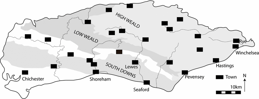
Figure 1: Map of Sussex showing the location of sites mentioned in the text (drawing: author).
Traumas of the fourteenth century
The ports all experienced similar challenges, posed by sudden traumas and longer-term processes. Sudden and long-term trauma cannot be easily separated and are often related, as seen in the processes of flooding, erosion and silting up. Property on the strand in Rye was reported as inundated in 1344 whilst coastal areas of Hastings, Seaford and Shoreham were lost to the sea.Footnote 7 However, flooding principally affected the ports’ agricultural hinterlands. Throughout the fourteenth century, flooding affected the marshes around Winchelsea and Rye and measures were taken to defend them, including the construction of a seawall known as Damme. In those areas of the marsh, for example the manor of Udimore, where agriculture remained possible, the late 1360s and early 1370s saw a peak in the amount of land under arable cultivation; however, the breaching of Damme in the 1370s saw the amount of cultivable land drop, and with it arable yields. Areas of flooded marshland laid unreclaimed in some cases into the fifteenth century.Footnote 8 The Pevensey Levels were also periodically flooded. Here too, measures such as the excavation of drainage ditches were taken to prevent flooding.Footnote 9 These measures taken to prevent the flooding of agricultural land had longer-term impacts, particularly for the ports of Winchelsea, Pevensey and Rye. Inning (land reclamation) led to silting of the harbours and this was particularly felt in Winchelsea, where by 1344 nearly half of the harbour-side plots had been abandoned.Footnote 10 Whilst the deep water harbour at the Camber remained in use, particularly for the mustering of the naval fleet, access for large merchant ships was restricted. Coastal processes meant that by the 1490s Rye had the only deep water harbour between Portsmouth and London.Footnote 11 Pevensey Haven also silted up, and was eventually drained and converted into farmland, although boats continued to be able to beach. The harbour at Seaford silted up in the sixteenth century.Footnote 12
The impact of the Black Death is difficult to judge. In population terms, we see decline in some places, such as Seaford, but this cannot be exclusively linked to plague. Approximately 40 per cent of Rye's population perished.Footnote 13 Elsewhere, for example in Pevensey, any population loss appears to have been fairly rapidly addressed, although this was not the case in its hinterland.Footnote 14 The ports were also subject to French raids. Seaford was raided in 1339 and 1340, and lands around the town lay uncultivated because of the fear of attack. A further raid in 1357 reportedly left the town in ruins and deserted; however, a further attack in the 1370s suggests there had been some recovery. Relief from the lay subsidy was provided in 1380 and 1384 due to raiding. In both Shoreham and Seaford, pits containing demolition debris might relate to raiding.Footnote 15 Pevensey appears to have escaped the raids, but Hastings was attacked in 1377 and 1399. Hastings, like Rye and Winchelsea, had a defensive circuit and all three were raided on multiple occasions. In 1326, around a quarter of Winchelsea's houses were burnt and a raid in 1360 was particularly vicious. A smaller area was enclosed by the fifteenth-century defensive circuit, the population of the town having been reduced both by the raids and the Black Death.Footnote 16 Like coastal flooding, war with France also had longer-term implications. War not only led to raids on the ports, but also brought about trade embargoes and disrupted shipping. The Gascon wine trade, so important to the economy of Winchelsea, declined; however, Winchelsea and Rye continued as naval dockyards, and whilst war impacted their trade, traffic continued to come through the ports as timber and iron were shipped from the Weald to other dockyards and supplies were transported through the ports. The naval role of these ports can be considered to have mitigated the economic impact of war to a certain degree, and stimulated the local economy in new ways.Footnote 17 Ports were clearly not immune to the national recession of the post-Black Death period. The relationship of the recession to the falling population and productivity levels is complex. It is clear, however, that there were opportunities for individuals to prosper in the port towns, even when the wider economic picture was gloomy.Footnote 18
Assessing urban fortunes: methodology
The measurement of urban decline and decay has typically been undertaken using tax records. Such records are principally economic indicators and their validity and meaning is much debated.Footnote 19 Archaeological evidence offers the opportunity to explore the potential of further indicators of urban change.Footnote 20 Although the evidence is partial, typically being gathered in a piecemeal manner as the result of modern development, archaeology allows a multiscalar approach to urban fortunes to be developed. The following indicators have been chosen, the evidence for which is summarized in Table 1.
Table 1: Summary of the evidence for urban change in the ports under discussion
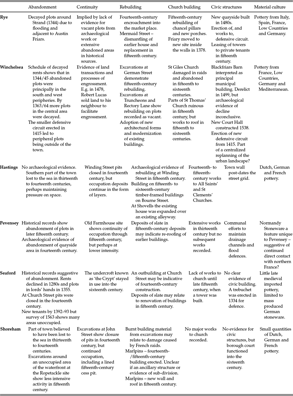
Sources: The information for this table is drawn from the following sources: Draper, Rye; G. Dawkes and J. Briscoe, ‘An archaeological watching brief at 31 Mermaid Street, Rye, East Sussex’, unpublished Archaeology South East Report (2012); A. Margetts and A. Williamson, ‘Archaeological watching brief and historic building recording report. The George Hotel, High Street, Rye, East Sussex’, unpublished Archaeology South East Report (2014); Martin and Martin, New Winchelsea; D. Martin and D. Rudling, Excavations in Winchelsea, Sussex 1974–2000 (London, 2004); D. Rudling, ‘Excavations in Winding Street, Hastings, 1975’, Sussex Archaeological Collections, 114 (1976), 164–75; D. Devenish, ‘Excavations in Winding Street, Hastings, 1974’, Sussex Archaeological Collections, 117 (1979), 125–34; Rudling and Barber, ‘Excavations at the Phoenix Brewery site’; Dulley, ‘The level and port of Pevensey’; A. Dulley, ‘Excavations at Pevensey, Sussex, 1962–6’, Medieval Archaeology, 11 (1967), 209–32; L. Barber, ‘The excavation of land adjacent to the Old Farmhouse, Pevensey, East Sussex, 1994’, Sussex Archaeological Collections, 137 (1999), 91–120; Freke, ‘Excavations in Church Street’; Gardiner, ‘Aspects of the history and archaeology of medieval Seaford’; S. Stevens, ‘Excavations at 1–3 High Street, Seaford, East Sussex’, Sussex Archaeological Collections, 142 (2004), 79–92; Thomas, ‘Refining the biography of a marketplace tenement’; S. Stevens, ‘Archaeological investigations at the Ropetackle site, Shoreham-by-Sea, West Sussex’, Sussex Archaeological Collections, 149 (2011), 59–158; S. Stevens, ‘Excavations at No. 5 John Street, Shoreham-by-Sea, West Sussex’, Sussex Archaeological Collections, 147 (2009), 97–110; N. Pevsner and I. Nairn, Sussex (New Haven, 2003).
-
• Evidence for occupation and rebuilding. The abandonment of plots is often taken as an indicator of urban decline, but archaeological evidence allows for a continuum of activity to be examined, from abandonment through to continuity and rebuilding. In particular, evidence for rebuilding allows for an assessment of individual prosperity, evidenced not only by building but also the adoption and development of new architectural styles.
-
• Archaeological and architectural evidence of civic investment. Works to parish churches and religious houses as well as to civic infrastructure such as town walls provide an indication of prosperity and civic organization.
-
• Material culture. Objects provide evidence of both investment in material possessions and the persistence of trading networks, which may exist below the level recorded in documents. Imported pottery in particular provides evidence of continued coastal trade.
Objects may also provide evidence of the intensity of craft production, although such evidence is not present from all of the towns under consideration here and, therefore, is not discussed. A further form of evidence is provided by environmental remains; however, these were collected too inconsistently to be given detailed consideration here.
Abandonment, continuity and rebuilding
The extent and timing of plot abandonment varies greatly. In Hastings, Rye and Shoreham there is little evidence for abandonment. In Hastings, where a new element was added to the street plan in the fourteenth century, and in Shoreham, this could be due to the loss of land to the sea, which increased pressure on space. In Rye, a small number of plots are recorded as decayed in 1344, but the compact nature of the town's topography may have ensured pressure on space was retained.Footnote 21 Following the Black Death and French raids, the Friary was relocated inside Rye's walls, with a series of land transactions taking place to secure the land, with this process perhaps soaking up any vacant land.Footnote 22 In Winchelsea, surveys of 1344/45 and 1363/64 provide detail of decayed plots, but archaeological excavation demonstrates that plots within the area enclosed after 1415 were reoccupied. There was also continuity in the town's land market. Whereas Winchelsea shrank, the town seems to have been replanned to be better suited to a reduced population.Footnote 23 In contrast, Pevensey and Seaford provide evidence for abandonment, both in terms of records of decayed plots and archaeological remains.Footnote 24 However, in all of the towns, and particularly in Shoreham and Hastings, archaeology suggests elements of continuity, although depositional processes did change from deposition in pits to the accumulation of layers, implying reduced pressure on space within some areas.Footnote 25 Similarly, in Rye the cultivation of a backyard at 12 Lion Street suggests limited pressure on space.Footnote 26 However, high-density occupation is demonstrated in both Rye, where buildings encroached on the market place, and Hastings, where at least one house encroached onto an alley.Footnote 27 Evidence for rebuilding and maintenance is varied. Deposits of slate and rubble in Seaford, Shoreham, and Pevensey may relate to episodes of refurbishment, particularly after raiding, whilst there is archaeological evidence of fifteenth-century rebuilding on sites, including those which were not abandoned in all of the towns.Footnote 28 Whilst not necessarily indicating prosperity, these works do demonstrate an ability to recover and address the effects of sudden trauma. The presence of new architectural forms, such as Wealden Halls, and the modernization of existing buildings are suggestive of prosperity.Footnote 29
Civic and church building
The erection and maintenance of defences from the thirteenth century in Rye, Winchelsea and Hastings provide strong evidence of civic investment and co-ordination. However, in Rye at least, the financial hardships related to defence are also apparent, with towers being leased to private individuals in the 1430s.Footnote 30 In Rye, and probably elsewhere, the high death rate brought about by attacks and the Black Death impacted the urban oligarchy, as survivors were able to benefit from deaths by capitalizing on opportunities to build both power and individual wealth.Footnote 31 Fifteenth-century works to the parish church, as well as the relocation of the Friary (in 1378), in Rye have been suggested by Draper to relate to the townspeople investing in spiritual protection; however, it should also be noted that the church had a dual function, being the location of civic meetings.Footnote 32 In the fifteenth century, substantial works took place to churches in Rye, Winchelsea and Hastings and a new tower was built in Seaford.Footnote 33
Material culture
A range of later medieval imported pottery has been recovered from all of the towns. The most diverse assemblages are from Rye and Winchelsea, whilst in Seaford only mass-produced German stonewares were present.Footnote 34 This highlights differences in the supply of pottery to these towns, with Rye and Winchelsea engaging in direct trade with the Low Countries. Mediterranean pottery may have been acquired through the larger ports in England or the Low Countries. In Shoreham and Hastings, a narrower range of imports are present, perhaps indicating that these towns acquired pottery through redistribution.Footnote 35 In Pevensey, the presence of Normandy Stoneware, not present in the other ports, may suggest the maintenance of direct contact with northern France.Footnote 36
Summary
A single narrative of decline and decay cannot be applied to these towns. In Rye and Hastings, there is evidence of personal prosperity in the fifteenth century and investment in new architecture, whilst civic investment was also high. The archaeology suggests that Winchelsea and Shoreham reduced in size, but that there was also continuity and rebuilding. In both Pevensey and Seaford, the intensity of activity clearly fell. The pressure on space seen in Hastings and Rye through encroachment is not evident in these smaller towns, where large areas were given over to cultivation or waste deposition. Imported pottery demonstrates that all of the towns maintained some trading relationships. Rye, Winchelsea and Shoreham had a range of trading connections, with the close links between Rye and the Low Countries being apparent. The small quantities in the other ports may be suggestive of coastwise or direct trade with northern France and the Netherlands. Therefore, fortunes varied and the various traumas of the fourteenth century did not have a uniform effect. As such, we might question whether decay and decline are useful paradigms within which to understand towns, or whether it might be more fruitful to focus on change and transformation, both within these places and also more widely, in relation to how later medieval towns were constituted. The remainder of this article is concerned with developing an interpretive framework to extend such a perspective.
Why did urban fortunes vary?
In order to develop a framework which focuses on processes of change and transformation, we can turn to recent approaches in urban geography and archaeological theory in which towns might be considered ‘assemblages’, formed of networks of social relationships.Footnote 37 By examining how these relationships formed, developed and dissolved, we can move towards a multilayered narrative and interpretation of urban development. Such approaches are inspired by the writing of social theorists such as Deleuze and Guattari, as well as related theoretical approaches, particularly Actor-Network Theory.Footnote 38 Towns can be considered as constituted of social relationships, between people, things, spaces and the environment (all of which we can term ‘actants’). As such, towns might be considered ‘iterative assemblages’, which re-emerge through the performance of social and economic practices.Footnote 39 In asking why fortunes vary, we are effectively seeking to understand the resilience of different elements of urban assemblages. This does not mean that we are seeking to see assemblages persisting in an unchanged form, but, rather, we are asking why some places appear to be better able to undertake adaptations in response to traumas, whilst other places, or elements of places, are not. Contemporary economic approaches suggest that places constructed of looser social and economic ties, that is with a broad economic base and the ability to adapt, are better placed to respond to trauma than those with highly specialized economies.Footnote 40 Here, however, the approach taken is different in that it seeks to understand why some elements of urban life persist and others do not, through a focus on the organization and replication of the social relationships which constitute the town. Therefore, in what follows, the concept of the assemblage is elaborated upon in order to consider how the character and persistence of social relationships might be utilized as a tool to examine varying urban fortunes in the medieval period.
Towns in regions
Following Deleuze and Guattari, we can perceive of towns being formed by the coalescence, or ‘territorialization’, of flows of actants.Footnote 41 By following these flows, we can explore both how towns emerged and were reiterated and the impact of disruption to these flows by traumatic events. Fish offer a useful example of a flow to illustrate this concept. Fishing was an important element of the economies of all of the towns, for example in Old Winchelsea in 1267 it accounted for 48 per cent of revenues and fishing equipment has been excavated from several of the towns. Excavated fish remains demonstrate the exploitation of local fisheries.Footnote 42 Fishing was also important to small coastal communities. In simple terms, two flows of fish can be traced. The first is from the east coast, arriving through the Yarmouth market. The second are the catches of fishermen exploiting local fisheries. On the whole, the same boats and fishermen were exploiting both fisheries, although smaller fishing communities are likely to have focused on local fishing.Footnote 43 The Cinque Ports enjoyed privileged access to the Yarmouth herring fair in the thirteenth century, but in 1303 they complained that they were being excluded from the trade and the importance of the fair declined during the fourteenth century.Footnote 44 Rye and Winchelsea acted as regional hubs for the processing and sale of catches.Footnote 45 Ongoing interactions with fish therefore led to the reiteration of social networks surrounding fishing and fish processing.
Within Deleuze and Guattari's concept of the assemblage, flows must be ‘coded’ in order for social relationships to reform. Flows are, in theory, free to create random and multiplicitous entanglements, but historical processes channel flows along particular trajectories and block off other possibilities.Footnote 46 For example, the flow of Yarmouth fish was coded by the rights of the Cinque Ports, rights which allowed fish to flow into some places and not others. If we perceive of flows moving across a social plane, coding striates this plane, restricting the ways in which flows can become entangled and creating the possibility for the structured replication and reiteration of social relationships (Figure 2).Footnote 47 An assemblage lacking any code, inhabiting an entirely smooth social plane, is unable to replicate as flows are undirected.

Figure 2: A depiction of flows moving through smooth and striated social space (drawing: author).
Changes to the coastline and economy of eastern England disrupted this flow of fish and, as the social relationships formed through east coast fishing dissolved, the social space that fishing networks inhabited was smoothed. Trauma can be seen as smoothing social space, removing or overwriting coding structures. The assemblages created through east coast fishing were so rigidly coded, being reliant upon a single mechanism for obtaining fish, that once the code was overwritten, the social relationships were unable to replicate. These external impacts also demonstrate a further important concept within assemblage theory, that of de-territorialization. Assemblages are rarely isolated, rather they are de-territorialized, as elements of one assemblage are, simultaneously, enrolled in other processes of assemblage.Footnote 48 This means that assemblages ‘overflow’ their boundaries and have implications for each other.Footnote 49 Fish were enrolled in the assemblages of our towns, but also caused these towns to be de-territorialized into further assemblages, such as the east coast fisheries, meaning that changes in these distant assemblages reverberated through social networks.
However, some elements of towns persist, whilst others are lost. Fishing created social and economic networks, or communities, within coastal settlements as people worked together to crew fishing boats and process fish processing in the household (an activity often undertaken by women).Footnote 50 Whilst the focus of fishing increasingly shifted from the North Sea to local fisheries, fish remained important elements of the ports’ societies and economies. Social relationships form at different scales and therefore towns can be perceived of as stratified assemblages of assemblages, in which processes of de-territorialization cause scales to become enfolded into one another, with a performance at one scale having implications at others. Within these towns, fish are ‘assemblage convertors’, actants which link assemblages across space, time and scale.Footnote 51 East coast fishing was just one set of relationships which constituted the assemblages of these towns, extending their social networks over wide areas, fish being the medium through which these webs of social relations was localized. Fishing fleets were drawn from the Cinque Ports, for example, but these fleets were crewed by people who formed parts of households who processed or sold fish. Flows of fish were coded by the documented rights of the Cinque Ports over the North Sea fisheries, but also by the presence of fishing infrastructure in the towns. These coding elements allowed fishing to mediate the reiteration of social relationships in the household, at the market and extending beyond the town into the markets which Rye and Winchelsea provisioned.
We can see, therefore, that although the towns were no longer heavily involved in the east coast fish industry, local fishing activities reiterated local social networks of fishermen and fishing households, whilst developing the infrastructure to land, process and market fish. The social space of fishing was not entirely smoothed by the east coast developments. Whilst the coded flows of east coast fish were lost, the reiteration of local networks persisted. Therefore, the fifteenth-century fishing industry centred on Rye emerged from the thirteenth- and fourteenth-century east coast fishing industry, which created the infrastructure and coded flows of fish. The social relationships formed through local fishing were likely formed on an ad hoc basis and formed a smoother social space, striated by the geography of fishing but with greater freedom for social relationships to form. Local fishing was more adaptable and demonstrates greater resilience as social relationships were able to be reiterated, albeit perhaps at a lower intensity. Therefore, some elements of the town can be shown to be more resilient than others, with both the nature of the actants and the form of an assemblage being important factors in the ability of social relationships to reform and for a place to persist. Resilience can be conceived of as a product of social relationships, a phenomenon which can emerge at multiple scales and take a variety of forms.Footnote 52 The close link between households and the organization of local fishing also caused the commercial and domestic to blur into one another. The demand for fish from religious houses and inland markets, without access to this resource, was a further way in which flows of fish were de-territorialized and contributed to the agency driving the reiteration of fishing-based relationships.Footnote 53 By examining the relationship between flows of actants and the town, we can begin to see how some strata of the urban assemblage demonstrate greater resilience than others.
Fishing and trade were the key economic activities associated with the ports. The development of these activities can be compared, but it must also be emphasized that through actants such as landing places, boats and mariners, they were activities which were entangled with each other, with fish perhaps being best characterized as a specific form of commodity traded through the ports. France and Flanders were the principal overseas trading partners, the Gascon wine trade being important to the thirteenth- to fourteenth-century economies of Rye and Winchelsea, and the wider variety of north French imported pottery in Pevensey, Shoreham and Seaford attesting to contact through the wool industry.Footnote 54 The loss of the Gascon wine trade due to war with France as well as the silting of the harbour clearly had a profound impact on Winchelsea's overseas trade. The loss of Normandy and disruption to shipping caused by war with France also reduced trade. More generally, Sussex trade suffered as the export market shifted from the trade in wool to the trade in processed cloth.Footnote 55 As with the fish trade, the loss of highly coded and de-territorialized sets of social relationships caused elements of the assemblage, such as those relating to the Gascon trade, to cease to be reiterated. Here, we can see how the organization of the social relationships which emerged through trade limited resilience. However, long-distance trade was not only coded by commercial and political relationships but by the physical geography of the port, with silting recoding trade by excluding ports such as Winchelsea from certain trading activities.
It is, therefore, important to identify continuities, the elements which might be identified as more resilient and which created the foundations from which Winchelsea and the other ports could transition into a phase of reorganization and recovery. Despite the decline in trading activity, trade with northern France and the Low Countries, as well as coastwise trade, persisted at a lower intensity; as with fishing, social networks within the towns continued to be reiterated through ongoing, if changed and less intensive, trading activity. Ceramic evidence suggests a regional decline in contact in the late fourteenth century but revival in the fifteenth, when wares such as Normandy Stoneware and Low Countries Redware appear in assemblages. Although coastal change limited the capacity of harbours at Winchelsea and Shoreham and eventually led to Seaford losing the ability to function as a port, their location and the presence of port infrastructure allowed them to retain their port role. It was difficult for trade to move to new places; ports developed at the natural harbours, and maintained the infrastructure for trade such as quays and warehouses, whilst trading rights were enshrined in legal documents. This infrastructure, the result of historical processes, coded flows of goods.
Trade was also able to persist because of the strong export base. Every Sussex port was involved in the exportation of timber from the Weald, a bulk, but low-value, product.Footnote 56 Other traded goods included Wealden iron and wool from the Sussex downs. Demand came from London and the continent and, despite the disruption caused to shipping by war, the naval demand for timber and iron meant that traffic through Winchelsea and Rye persisted.Footnote 57 The staple nature of these products meant that there would always be markets for this trade, but adaptations were needed to ensure that ports were resilient to both supply and demand side traumas and shocks. Increasingly, shipping was in English hands, allowing the port communities greater power over commercial activity. As in earlier periods, boats were used for multiple functions, including as trading and fishing vessels, but by the fifteenth century the balance had shifted towards the use of these smaller, multipurpose boats rather than larger merchant ships.Footnote 58 Urban merchants also continued to diversify their economic interests, for example by investing in rural land.Footnote 59 Local coastwise trade is also demonstrated by the distribution of pottery, and agricultural produce moved along the coast. Rye, Winchelsea and Hastings were all important regional markets, whilst other ports, such as Seaford and Shoreham, were less important in this regard, with this local marketing role being taken by the inland towns of Lewes and Steyning.
A further flow on which the success of towns was contingent was agricultural produce. The thirteenth century was a period of economic intensification in the Sussex countryside, characterized by the enclosure and drainage of marshland around Winchelsea and Rye as well as the reclamation of the Pevensey Levels.Footnote 60 Much of this work was undertaken under the authority of ecclesiastical landowners and the reclaimed land was under direct cultivation, although the early drainage and enclosure of Walland Marsh may have been undertaken, in part, by Rye merchants.Footnote 61 Landowners were responding to increasing grain prices and sought to maximize the economic potential of their estates. Across southern Sussex, mixed agricultural regimes were practised.Footnote 62 In the Weald, the river valleys were fertile, and oats, in particular, were cultivated. The cultivation of legumes can be related to the pastoral element of the economy, which, in the east, was principally comprised of cattle.Footnote 63 The Weald was an area of sparse, and generally poor, settlement; however, substantial lands within the Weald were held by the men of the Cinque Ports who clearly had interests in securing the supply of Wealden resources for export.Footnote 64 Further west, sheep-corn husbandry dominated. In this area, rents were often in the form of assize arrangements and there were extensive sheep flocks kept outside of the demesne.Footnote 65 On the whole, the agrarian economy appears to have survived through the crises of the early fourteenth century. Lands were improved and an intensive and varied cropping regime helped to mitigate against the effects of climatic conditions and disease, with the intensive husbandry regime on the Battle Abbey estate being particularly innovative.Footnote 66 Fluctuations in agricultural production continued into the fifteenth century, as the Hundred Years War stimulated agricultural production, only for poor harvest to halt this expansion. In this period, demesne farms were increasingly taken out of direct cultivation.Footnote 67 In the fifteenth century, and probably before, the towns of Winchelsea and Rye were largely reliant on crops imported through coastwise trade. Cattle reared around Winchelsea and Rye provided an important resource both for these markets and London.Footnote 68 Evidence also suggests the undertaking of horticulture within towns. In Rye, excavated garden soils are indicative of low-level horticulture, and in Seaford, where vacant plots were leased for pasture. Vacant plots on the outskirts of Winchelsea were also leased as fields.Footnote 69 Such changes indicate the intensification of household level subsistence activity in towns, perhaps due to a lack of income or interruption of supplies to the market, or perhaps as households took advantage of the presence of newly available land within towns. However, as discussed above, townspeople were involved in rural cultivation and processes of enclosure, particularly in the Weald around Winchelsea and Rye.
Ports were reliant on flows of agricultural produce, both for their own subsistence, but also to provide the goods for export. Like fish, agricultural produce is an ‘assemblage convertor’, it is a de-territorializing element which causes changes outside of the territorialized network of the town to have consequences for it. This is well demonstrated by Pevensey, where economic downturn, shown for example by the dramatic fall in revenues from the annual fair, can be linked to the fifteenth century, when flooding of the Pevensey Levels and an increasing demand for wool resulted in an abandonment of cultivation to focus on pasture. The cultivation of the Levels and the prosperity of Pevensey appear linked. Large workforces were employed in the undertaking of coastal defence works and townspeople were probably employed in the marketing of produce and as labourers.Footnote 70 Although the harbour silted up, coastal contact has been shown to have persisted, suggesting that the inaccessibility of the harbour was less important to Pevensey's fortunes than the absence of agricultural produce for processing and export. Here, we see a town lacking a diverse economic base and therefore having little control over its fortunes. Whilst there was a symbiotic relationship between the urban labour force and market and the rural hinterland, the power over this relationship lay in the countryside, and responses to external forces of coastal change and economic developments by the landlords ended this relationship. Pevensey suffered from an over-reliance on a precarious, and rigidly coded, flow of resources and was unable to adapt when this supply ceased.Footnote 71
A focus on the elements of urban life that persisted and those that were vulnerable takes us some way to explaining the differing fortunes of the towns under discussion. Fishing, so important to the economies of Rye, Winchelsea and Hastings in particular, appears to have been organized in such a way that communities could adapt and continue to reiterate the social relationships negotiated through this activity. This may, in part, account for the prosperity seen in Hastings and Rye, and demonstrate why Winchelsea, despite being cut off from flows of goods and resources, was able to persist, albeit at a lower intensity than it had previously. Similarly, trade did not cease, but adapted. Flows of traded goods, at a general scale, were coded by port infrastructure such as quays and warehouses. The socio-economic relationships emerging from trade, some of which were reiterated further through fishing and other maritime activity, were reiterated intermittently; the ports all appear to have maintained their role as landing places but were performed at a lower intensity than they had been in the thirteenth and early fourteenth centuries. The flow of agricultural produce through towns is a key differentiator, however. These flows were coded by tenurial arrangements and market demand; Seaford and Pevensey are both examples of places which appear overly reliant on the highly coded flows of rural resources. The naval demand in Winchelsea and Rye for Wealden resources allowed commercial coding to be over-written by the emergence of new provisioning networks. We also increasingly see attempts by urban merchants to recode flows of agricultural produce by investing in rural land and production, allowing them to take greater responsibility for their own prosperity. What this analysis demonstrates, therefore, is that different types of social relationships, equating to different elements of urban life, were more persistent, or resilient, than others, and this had a direct bearing on the fortunes of the towns as described in the first part of this article.
Resilience at the micro-scale
On the whole, strong civic administration appears to have persisted in the port towns. Communal resources were directed to civic building projects, principally programmes of urban defence. Such defences are more than assemblages of stone and mortar; they are formed of flows of power, money and social relations within and outside of the town (for example through grants of murage). The example of Winchelsea, where a smaller area was enclosed in the fifteenth century, shows how urban spaces were dynamic, able to contract in order to adapt to a falling population, whilst retaining elements of urban character. Notably, the new defences enclosed the core of the town, where the administrative infrastructure such as the municipal hall, marketplace and parish church were located.Footnote 72 Defence and strong civic administration were crucial to medieval towns, both in terms of ensuring that they functioned effectively and as a means of preserving a town's reputation as a safe and trustworthy place to do business.Footnote 73 Administration and the oligarchical nature of medieval urban administration, particularly in places such as Rye and Winchelsea, might, on the surface, appear highly coded, administration being a highly striated and closed social network. The evidence hints, however, at something more complex. Civic buildings, regulations and procedures persisted, whilst the social relationships formed around them were less resilient. Whilst towns were poorer, administrative relationships were able to persist. Trauma smoothed elements of administration (for example by killing prominent members of the urban oligarchy), opening up new possibilities for individuals to gain power and influence, within a persistent administrative geography and bureaucracy. It is easy to assume that as towns shrank they lost their urban character, but such a broad-brushed approach fails to examine which elements of these towns persisted and how these persistent urban elements were active in the transformation of towns in the later Middle Ages.
This reorganization also offered opportunities for transformations in domestic life, particularly in relation to standards of living. New types of domestic architecture were constructed and plots were enlarged. Decaying properties need not have fallen out of use because the occupants left towns, their occupants may have simply moved to a larger, more desirable, or simply more intact, plot. For example in Seaford, the undercroft known as ‘the crypt’ remained in use into the sixteenth century and waste was dumped in areas previously occupied by denser housing.Footnote 74 In Winchelsea, vacant plots in the north-east of the town were quickly reoccupied, as population decline possibly offered opportunities for people to vacate the poorly built houses constructed during its foundation to live in better-quality homes situated in its commercial and administrative core.Footnote 75 Architectural developments, such as the erection of Wealden houses (which potentially began as an urban phenomenon) and fully floored houses in Hastings, Winchelsea and Rye are demonstrative of personal prosperity in a time of general economic depression.Footnote 76 Ports had a particularly high concentration of wealthy individuals, but these houses not only raised the standards of living of the rich, but, given the presence of quality housing stock and a lower overall population, it is possible that standards of living were also raised for those poorer townspeople renting rooms in modern townhouses. Some of these new houses are indistinguishable from those found in nearby small towns and rural areas, whilst others are of a distinctly urban character, featuring shops.Footnote 77 For the newly wealthy, household activity retreated to the parlour, the meaning of the hall becoming renegotiated, in some cases, as a space for the display of wealth and prosperity, perhaps in others as practical spaces.Footnote 78 This rebuilding and modification of existing houses mirrors developments in inland towns and the countryside, where houses were being altered or ‘modernized’ in a number of ways demonstrative of the variety of functions to which they were put. However, despite the changes to architecture, some continuity can be perceived at the domestic scale, distinctions between spaces within buildings appear to have persisted, for example.Footnote 79 Logics of space and domestic practices could also be passed on through domestic service, with the mobility of the workforce creating opportunities for the transfer of modes of domesticity between town and country.Footnote 80 Domestic assemblages transformed as new forms of architecture were adopted, facilitated by increasing personal prosperity amongst some town dwellers.Footnote 81 Domestic social space was striated in a number of ways, through service, familial and commercial relationships, for example, and it is the persistence of these relationships which might be seen as being responsible for the reiterations, or continuities, apparent in elements of domestic life.
At the micro-scales of administration and domesticity it is, therefore, possible to determine processes of both continuity and change. Both sets of social relationships were coded by persistent forms of social organization such as the family, a service culture and administrative procedure. However, the spaces between these striations were smoothed by traumas. Raids and the Black Death opened new possibilities for survivors to gain power and build prosperity whilst the destruction of property by raids perhaps stimulated the adoption of new architectural styles in the ports, buildings structured by persistent elements of domestic organization, but built in a way that articulated them in new ways. Clearly, these micro-scale social assemblages overflow into the regional-scale networks discussed above. It is in the most prosperous towns that we see the most intensive rebuilding, for example the evidence from Hastings and Rye is lacking from Pevensey and Seaford. However, even in these poorer towns the evidence for continuity in elements of domestic practice, in the form of material culture, rebuilding and the continued occupation of houses suggests the reiteration of these micro-scale networks, although urban life persisted at a lower intensity than elsewhere.
Discussion
By advancing a framework of towns as assemblages, comprised of different social spaces which are striated by past action and smoothed by trauma to varying degrees, it has been possible to explore how certain elements of urban life persisted and others were transformed or lost. It is clear that a multiscalar approach, drawing upon different strands of evidence, is required to understand the subtleties in the transformations which these places experienced. Looking at the towns as a whole, three groups emerge. Rye and Hastings appear prosperous, with social networks built around fishing persisting as, by the end of the fifteenth century at least, did the flow of goods coming into Rye, allowing individuals to become wealthy as the commercial functions of these ports to remain. Similar persistence can be argued for Shoreham and Winchelsea, with these places perhaps being performed at lower intensities. Both decreased in size, yet there is strong evidence for the continuity of urban administration and economic activity, resulting in personal prosperity and rebuilding. The final towns, Pevensey and Seaford, had larger open spaces and low population densities. In both cases, these ports suffered from coastal processes but were also strongly reliant on highly coded flows of resources over which they had little control. The resilience of places is strongly determined by historical processes, which establish how places emerge and the form that the social relationships which constitute them take. We can also see how, across the towns, different areas of port life were more resilient than others. Fishing, for example, appears to be more adaptable than trade. However, trade was coded by historical processes meaning that, although it fluctuated, it continued to be focused on places situated in the right location and had the necessary infrastructure in place. Elements of domestic and administrative life also persisted, with trauma serving to smooth elements of these social relationships, whilst other social structures were more stubborn.
This discussion calls into question whether urban decline is a useful concept. Population and prosperity certainly fell and some towns suffered more than others. But when we look at the social fabric of these places elements of persistence, transformation and adaptation are evident. Urban decline supposes a framework of regression but it is more useful to suggest that in the face of economic and social stresses these communities adapted and persisted; elements of the social structures which made these places distinctive as ports and as boroughs continued but what it was to be a port town changed. Perhaps Winchelsea and Shoreham did decline to the extent that they might be considered more landing places than major ports by the early modern period, perhaps Seaford and Pevensey did decline to villages. But elements of their social fabric were retained. Households persisted, fishing communities continued to be reiterated and urban administrative structures continued to be enacted; elements of urban character remained but just as the wider socio-economic landscape was changing, so was the character, and role, of towns within it.Footnote 82
This analysis supports the turn from urban decline to urban reorganization; however, it also stresses that this reorganization did not take place in isolation, being part of a wider transformation of the relationship between town and country.Footnote 83 It is well established that from the fifteenth century what it was to be rural was changing, as processes of enclosure changed how people related to the land, a process also associated with the emergence of new forms of identity. By mapping how the performance of urban life changed over the period, it is possible therefore to see how, through adaptation, what it was to become urban, to perform the town, changed. Such changes made towns more resilient; the increasing commercial interest in the countryside on the part of townspeople, for example, increased their control over resources and built resilience through the de-territorialization of the town and the renegotiation of its relationship to its hinterland (for example as burgesses acquired rural land). It was those towns which were able to exert some control over resources, chiefly the ports in the eastern part of the county which prospered. This is one example of why, if we are to understand what happened to towns in the later medieval period, we need to understand their wider relationships, as well as the character of the relationships which defined their internal social fabric.
Conclusion
In the first part of this article, it was demonstrated that archaeological evidence can supplement the traditional indicators of urban fortunes to introduce further subtlety in our understanding of variations in urban development. A framework, influenced by assemblage theory, was then advanced to seek to understand why fortunes varied. It has been argued that towns are formed of flows of actants and that historical processes determined the kinds of relationships which could form and be reiterated within a town. It is proposed that the key to understanding why towns experienced different fortunes is understanding how social relationships were structured and which elements of urban life were able to persist. It was argued that whilst we can see some towns as being more rigidly ‘striated’ than others, making them more vulnerable to the impacts of trauma, if we examine the flows through towns more closely then we can identify elements of urban life that were more persistent, or resilient, than others. A focus on the ‘de-territorialized’ character of urban assemblages also brings into focus the need to understand towns in relation to their hinterlands. It is argued that asking whether or not towns declined is less useful than asking how they changed and transformed. This refocusing has led to the suggestion that what it was to be urban changed in the later medieval period and that shrinkage or a lack of wealth should not, necessarily, be seen as decline but rather as part of a wider societal transformation of which urban change is one part. In conclusion, therefore, it is proposed that archaeology offers tools for building more subtle understandings of urban fortunes and that the mutiscalar and interdisciplinary interpretive framework offered by assemblage theory offers a useful analytical tool for not only exploring the question of urban fortunes and resilience at different scales, but also for challenging our assumptions about what towns were in the medieval period.


 Open access