Full Text
Introduction – Global Observations of the Interior Ocean
The complementary partnership of the Global Ocean Ship-based Hydrographic Investigations Program (GO-SHIP; https://www.go-ship.org/) and the Argo Program (https://argo.ucsd.edu) has been instrumental in providing sustained subsurface observations of the global ocean for over two decades. Since the late twentieth century, new clues into the ocean’s role in Earth’s climate system have revealed a need for sustained global ocean observations (e.g., Gould et al., 2013; Schmitt, 2018) and stimulated revolutionary technology advances needed to address the societal mandate. Together, the international GO-SHIP and Argo Program responded to this need, providing insight into the mean state and variability of the physics, biology, and chemistry of the ocean that led to advancements in fundamental science and monitoring of the state of Earth's climate.
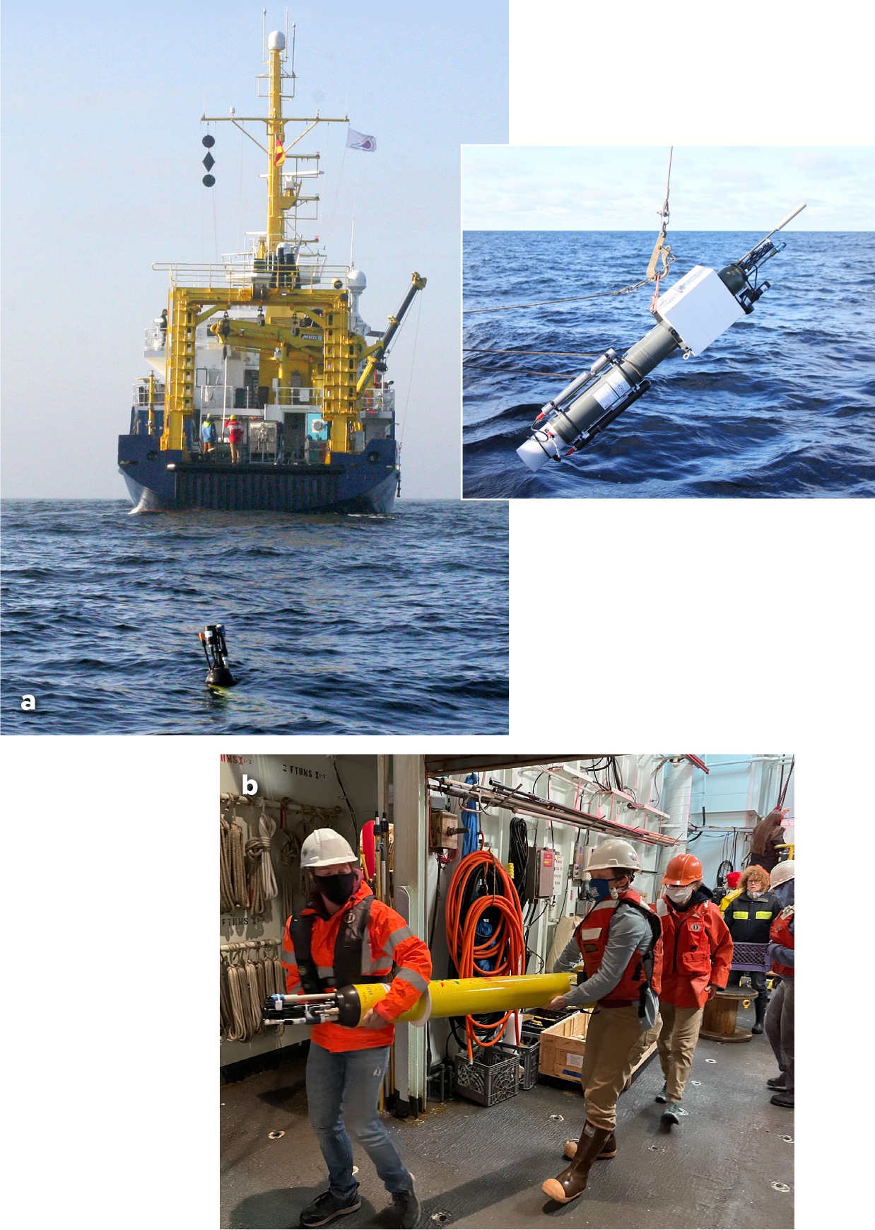
Historically, ocean temperature profiles have been obtained from commercial ships, although the highest quality temperature and salinity (T/S) profiles came only from research vessels (Figure 1). Global ocean hydrographic surveys, including full biogeochemistry and tracers, began in the mid-1990s under the World Ocean Experiment (WOCE) and continue now as GO-SHIP. T/S and biogeochemistry, as key variables of the climate system, began to describe variability and change in patterns of rainfall and evaporation, absorption of fossil fuel carbon dioxide into the ocean, and the pace and evolution of global warming and steric sea level rise (i.e., due to changes in ocean salinity and temperature, which affect density). However, because capturing these observations required research vessels, pre-Argo T/S data sets could not attain systematic global coverage. This changed in the 1990s with the development of autonomous profiling floats that enable high-quality T/S observations anywhere at any time. The Argo Program was designed as a global autonomous array of over 3,000 profiling floats spread evenly over the ocean where the depth exceeds 2,000 m, and it achieved this milestone in 2007. Free-drifting Argo floats obtain T/S profiles from 2,000 m depth to the sea surface every 10 days. All Argo data are distributed freely in near-real time (12–24 hours) and as research-quality delayed-mode data (nominally in 12 months). The transformation in ocean observing brought about by Argo, from exceedingly sparse and regionally biased coverage to systematic and sustainable global coverage, is apparent in Figure 1.
|
|

The combination of Argo and GO-SHIP provides today’s global observations of the ocean’s interior. GO-SHIP supplies the highest quality global-scale multi-parameter observations, including biogeochemical as well as physical properties, from the surface to the seafloor, repeated on decadal timescales. The accuracy of shipboard data makes it essential for climate change assessment, sensor development, and detection and adjustment of drift in Argo sensors (Sloyan et al., 2019). Additionally, GO-SHIP provides a scientific foundation for expanding Argo into full-depth measurements and for investigating the ocean’s biological and biogeochemical cycling (see next section on GO-SHIP). In turn, Argo’s systematic, autonomous sampling provides regional-to-global and seasonal-to-interannual coverage of T/S that are unattainable by conventional ship-based systems.
Argo has achieved and sustained global observations because: (1) it provides great value in basic ocean research, climate variability and change, education, and ocean forecasting (Johnson et al., 2022); (2) it is based on effective and efficient global technologies; and (3) it combines with GO-SHIP to provide an ocean observing system with unprecedented accuracy and coverage. Central to Argo’s and GO-SHIP’s successes are their multinational partnerships composed of academic and government researchers, agencies charged with ocean observing, institutions having global reach, and technically proficient commercial partners.
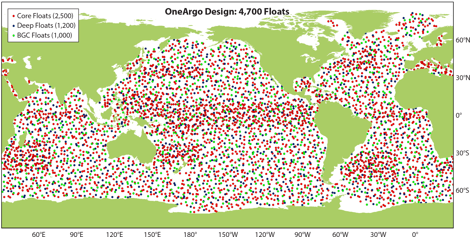
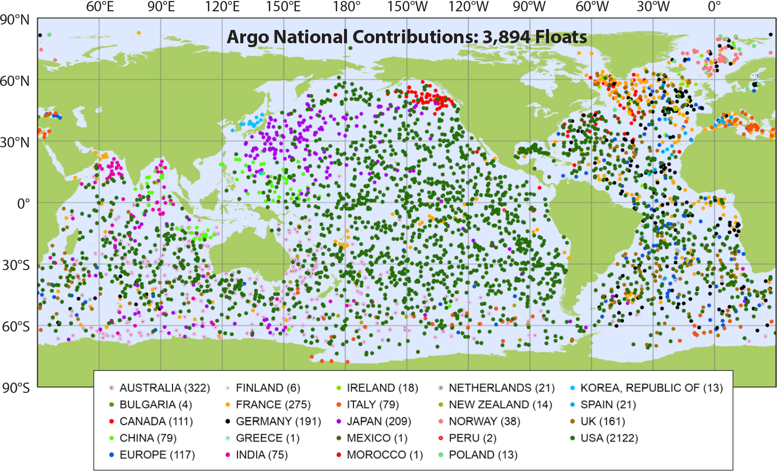
The transformation of ocean observing brought about by Argo and GO-SHIP is not complete. GO-SHIP is expanding to include ocean mixing measurements and biological observations. Deep Argo floats with 6,000 m capability are increasing Argo’s reach to nearly all the ocean volume, filling key gaps in our understanding of full-depth ocean circulation and heat uptake and their relationships with climate. New sensors for dissolved oxygen, pH, nitrate, and bio-optical properties have given rise to Biogeochemical (BGC)-Argo. Core Argo floats are being made more robust, long-lived, and versatile, enhancing Argo’s coverage, its sustainability, and the breadth of its applications. The integrated program of Core, Deep, and BGC-Argo (Figure 2), termed OneArgo, will continue the Argo revolution for science and society (Roemmich et al., 2019).
|
|
GO-SHIP – High-Quality, Decadal, Global Physical and Biogeochemical Observations
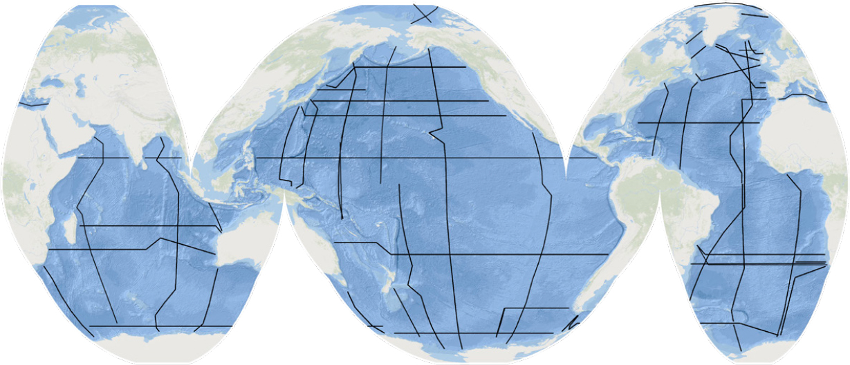
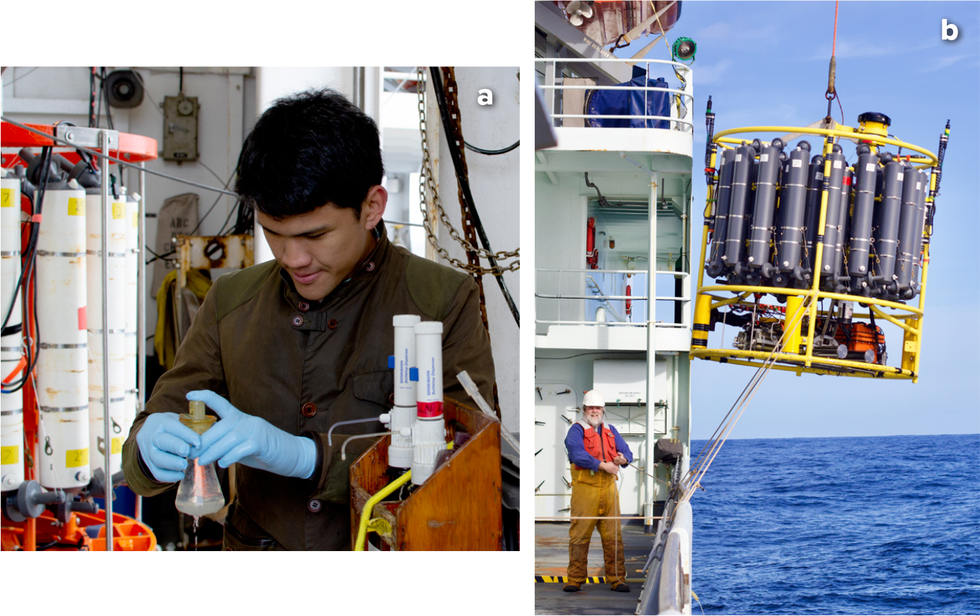
GO-SHIP’s quasi-decadal reoccupation of hydrographic transects spanning the global ocean was implemented and is sustained to quantify changes in the storage and transport of heat, fresh water, carbon, nutrients, and transient tracers (Talley et al., 2016; Sloyan et al., 2019; Figure 3). These full-depth, coast-to-coast transects measure many of the physical and biogeochemical essential ocean variables of the Global Ocean Observing System and provide the highest accuracy ocean data, attainable only with research ships and specialized, calibrated analytical methods (Figure 4). Three decades of GO-SHIP data have been central to the assessment of the state of the ocean throughout multiple IPCC reports (https://www.ipcc.ch/), and they are used in multiple climatologies (e.g., GLODAP; https://www.glodap.info/) for calibration and validation of autonomous instruments and for model initialization and validation.
|
|
|
|
Importantly, GO-SHIP provides the reference standard data central to calibrating Core, Deep, and BGC Argo sensors. GO-SHIP’s data sets are subject to rapid public release to maximize use as reference data and for biogeochemical assessments: preliminary data within six to eight weeks of the end of a cruise and final data within six months.
In this era of expanding autonomous observing systems, GO-SHIP, supported by the research fleet, remains the backbone of sustained observing. The following climate-related results have been based on GO-SHIP data (Sloyan et al., 2019, and subsequent works) and have led to the expansion of Argo into the deep ocean and to biogeochemical measurements to increase our temporal and spatial coverage of these climatically important phenomena.
- The deep ocean is warming and is increasingly contributing to sea level rise.
- The global ocean circulation and its physical, chemical, and biological properties are changing under changing winds and surface fluxes.
- Ocean oxygen content has declined since 1960, with loss at all depths; tropical oxygen minimum zones have expanded; upper ocean oxygen has increased in the Southern Hemisphere subtropical gyres.
- Multiple observing systems show that the ocean absorbs about 25% of excess CO2 resulting from anthropogenic inputs. From GO-SHIP, the total ocean inventory of anthropogenic carbon (Cant) has increased by 30% from 1994 to 2010. Anthropogenic carbon buildup can be detected as deep as 2,000 m and continues to acidify the ocean.
- Dissolved organic carbon distributions have been mapped globally for the first time.
While GO-SHIP’s sustained measurements have evolved conservatively for continuity, GO-SHIP provides a platform for piloting new types of observations anywhere in the world and for international collaboration on individual measurements and full cruises. Each GO-SHIP cruise includes multiple ancillary activities, including Argo deployments, ocean mixing measurements, and some biological observations. A new expansion to include “Bio GO-SHIP” has begun to investigate the distributions and the biogeochemical and functional roles of plankton in the global ocean. Routine sampling of plankton for genetic analyses is proposed, and microbial sampling has been conducted on several cruises. As GO-SHIP continues to monitor and expand to new parameters, it will inevitably reveal new climatically significant properties of the physics, chemistry, and biology of the global ocean, and inspire technological advancements in ship-based and autonomous measurements.
Core Argo – Sustaining and Improving Systematic Global Ocean Observations for Climate
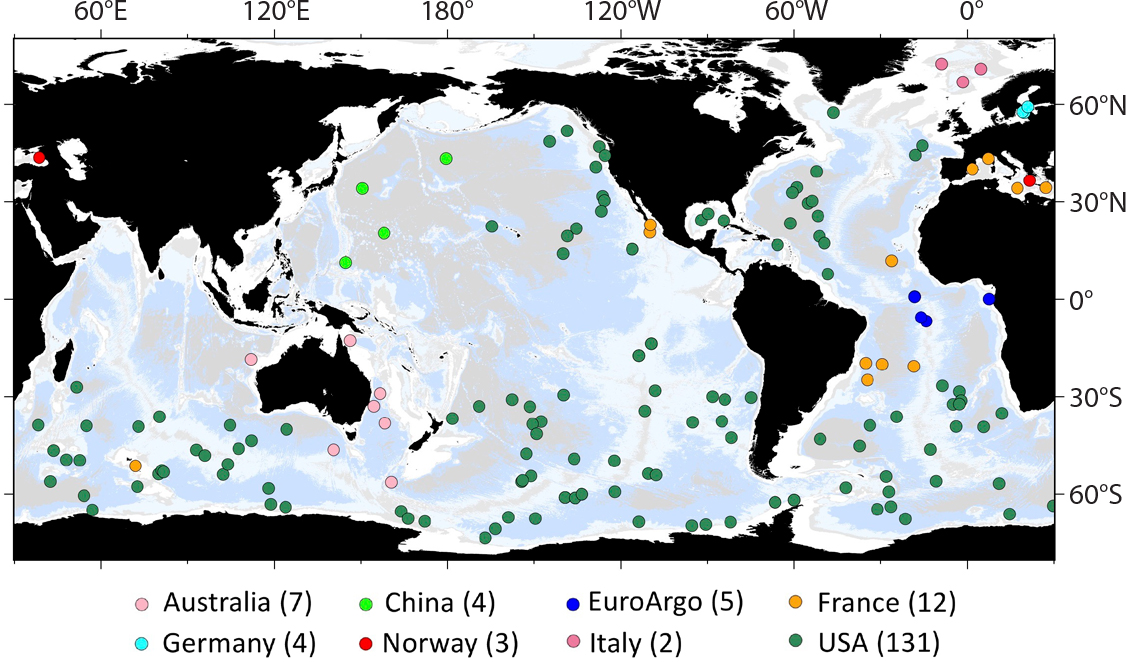
The highest priority for the OneArgo Program is to sustain and improve the longstanding Core Argo array (Figure 5). The sustainability of an observing system depends equally on the societal needs driving it and on its cost-effectiveness. Core Argo’s primary roles are in assessments of global warming, sea level rise, and the hydrological cycle, plus applications in seasonal-to-interannual ocean and coupled forecasting, and ocean state estimation. Other research topics that utilize Argo data include ocean circulation in interior and boundary current regions, mesoscale eddies, ocean mixing, marine heatwaves, water mass properties and formation, El Niño-Southern Oscillation, and ocean dynamics. Argo’s rapidly growing applications are well documented (e.g., Johnson et al., 2022), with about 500 research papers that use Argo data published per year.
|
|
While the scientific needs for Core Argo are strong, equally important are the technology advancements in profiling floats and sensors that are transforming the cost-effectiveness of the array while enabling new scientific missions.
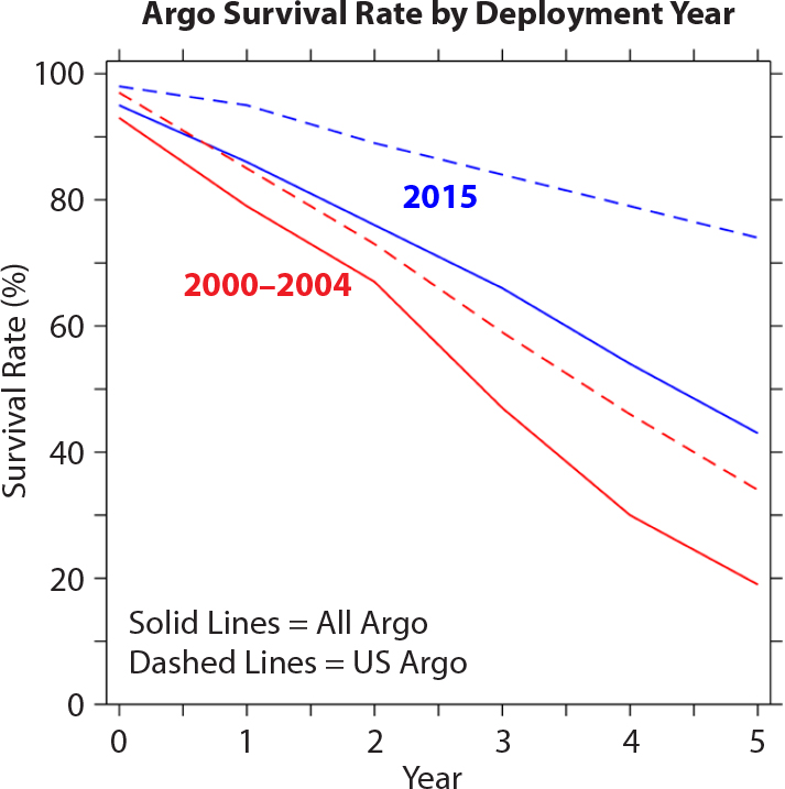
- Float engineering: Advances in the hydraulic system controlling float buoyancy have contributed to substantial decreases in float failure rates (Figure 6) while increasing energy efficiency for longer float missions.
- Battery technology: The use of improved (hybrid) lithium batteries since about 2016 is doubling the battery lifetime of some Core Argo float models from about five years to 10 years.
- Satellite communications: Around 2011, Argo communications transitioned from the one-way System ARGOS to the bidirectional Iridium global cellular network. A float’s time on the sea surface for data transmission was reduced from 10 hours to 15 minutes in each cycle, resulting in energy savings and avoidance of surface hazards, including grounding and biofouling. New applications have emerged utilizing the rapid data turnaround, while the bidirectional transmissions enable changes in mission parameters throughout float lifetimes.
|
|
In the transition to OneArgo, Core Argo coverage requirements (Figure 2) are increasing in key regions. Doubling of float density in the equatorial Pacific is needed by the Tropical Pacific Observing System (https://tpos2020.org). Similarly, doubling is needed in western boundary regions that exhibit high variability and in marginal seas adjacent to the continental shelves. Increasing coverage in high-latitude, seasonally ice-covered regions is accomplished by using T/S to infer ice-free conditions and by using ice-hardened antennas. The map of OneArgo coverage (Figure 2) shows that expanded coverage of 0–2,000 m T/S profiles will be accomplished even as the number of exclusively Core Argo floats decreases, because Deep and BGC Argo floats also collect 0–2,000 m (Core) T/S profiles. Core Argo will continue the technology and scientific revolutions that have transformed global observing from a vision to reality.
Deep Argo – Observing the Full Ocean Volume
Sustained measurements of ocean properties and circulation are needed over the full water column to provide fundamental insights into the spatial and temporal extent of deep ocean warming, sea level rise resulting from the expanded volume of deep ocean warming, and environmental changes that affect the growth and reproduction of deep-sea species. Deep ocean (>2,000 m) observing is sparse in space and time compared to the upper 2,000 m. Less than 10% of historical non-Argo T/S profiles extend to depths greater than 2,000 m, with current high-quality deep ocean measurements limited primarily to GO-SHIP transects repeated on decadal timescales, ocean stations located in special regions, and moored arrays set mainly near the coasts of continents.
To address the void in deep ocean observing, new Deep Argo float models are designed with high pressure tolerance in order to extend autonomous ocean observing to the abyss. New Deep Argo CTD sensors have improved temperature, salinity, and pressure accuracies and stability to resolve deep ocean signals. Use of a bottom-detection algorithm and bottom-detecting wires enables collection of temperature, salinity, oxygen, and pressure to as close as 1–3 m above the seafloor. The implementation of an ice-avoiding algorithm on all Deep Argo floats deployed at high latitudes enables deep ocean profiling under sea ice.
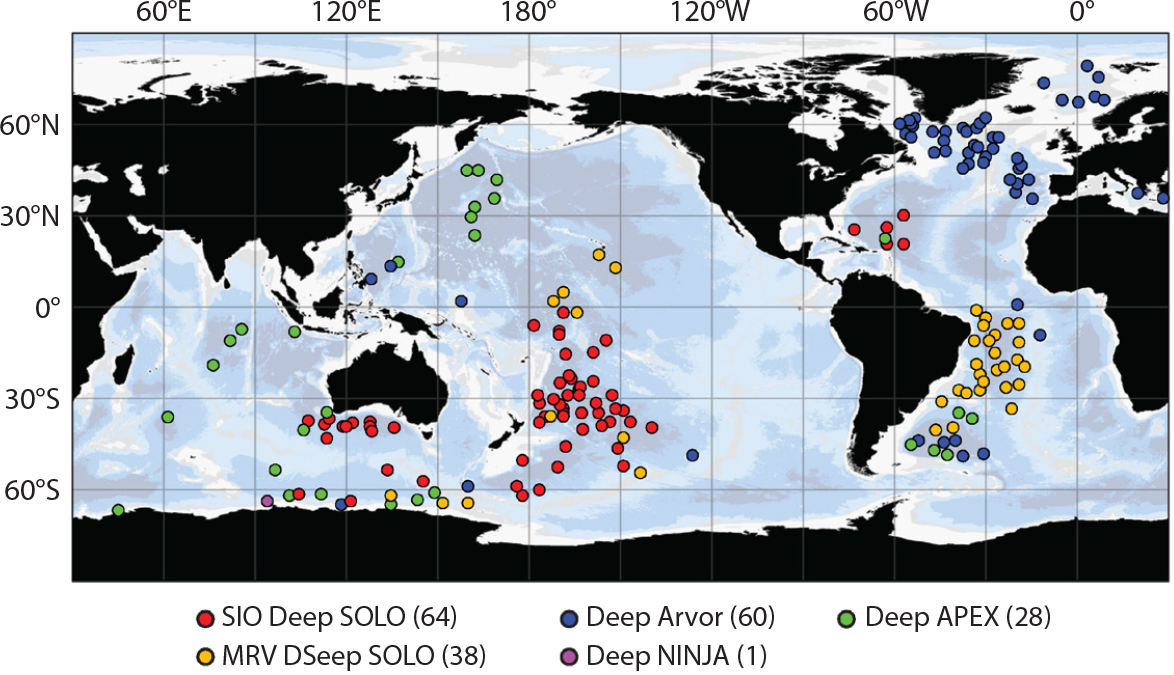
The Deep Argo fleet presently consists of pilot arrays implemented in deep regions where GO-SHIP data show strong ocean warming (Figure 7). Active float models include those capable of sampling from the surface to 6,000 m depth, and others that can profile to 4,000 m (Figure 8). Observations from the pilot arrays show float lifetimes reaching 5.5 years and sensor accuracies approaching GO-SHIP quality standards. Deep Argo’s ability is well demonstrated to measure variability of deep ocean warming and large-scale deep ocean circulation, both regionally and globally, at intraseasonal to decadal timescales. The international Deep Argo community is committed to implementing a global Deep Argo array of 1,250 floats in the next five to eight years and to sustain Deep Argo observations in the future (Zilberman et al., 2019).
|
|
|
|
With full implementation of the Deep Argo array, the temporal and spatial resolution of deep ocean observations will improve by orders of magnitude, enabling new insight into how the deep ocean responds to, distributes, or influences signals of Earth’s changing climate. Deep Argo’s homogeneous coverage of the full ocean volume in all seasons will be particularly useful to constrain and increase signal-to-error ratios in global ocean reanalyses and to prevent unrealistic drift in coupled climate-ocean models. Deep Argo will therefore increase our ability to predict climate variability and change and to anticipate and reduce the impact of more frequent extreme weather events, warmer ocean temperatures, and sea level rise. These all have damaging implications for various sectors of the blue economy that nations increasingly depend upon. Low-lying coastal communities and small island developing states are especially vulnerable.
Biogeochemical Argo – Simultaneously Observing Global Ocean Physics, Chemistry, and Biology
To date, observations of global ocean biogeochemistry have relied heavily on high-quality chemical measurements made by GO-SHIP repeat hydrography surveys and on biological measurements extracted from satellite ocean color sensors. However, ship transects miss most years, seasons, and ocean regions, and satellites cannot sample beneath the surface, leaving the vast majority of the ocean volume unsampled. Furthermore, the minimal overlap that exists in coverage between GO-SHIP and ocean color data complicates and hampers the study of biological-chemical interactions central to ocean biogeochemistry.
BGC-Argo (https://biogeochemical-argo.org/), an emerging element of the OneArgo design (Figure 2), will consist of a global fleet of 1,000 profiling floats, coordinated through the Argo national programs. The array will fill the coverage gaps described above and provide a near-real-time perspective of ocean biogeochemistry in the upper 2,000 m (Biogeochemical-Argo Planning Group, 2016). BGC-Argo floats (Figure 9) collect nominally six ocean property measurements in addition to T/S, including oxygen, nitrate, chlorophyll-a concentration, pH, suspended particles, and light. These data provide useful information on air-sea gas exchange, primary productivity, net community production, carbon export, climate-driven changes in chemical properties, and biogeochemical properties, which can be assimilated into models to increase their accuracy. The BGC-Argo array will link, complement, and extend existing observing programs, yielding unparalleled global-scale integration of physical, chemical, and biological measurements every 10 days.
|
|
Over the last decade, the number of BGC-Argo profiles has steadily increased, with more than half a million combined sensor profiles collected to date. This is the result of increased float longevity, improved sensor accuracy and stability, better manufacturing capability, and enhancement of data systems. Several well-established regional float arrays (Figure 10) have demonstrated excellent examples of scientific applications (Claustre et al., 2020), including using (1) oxygen measurements to study biological production and respiration, (2) pH and derived carbon products in the Southern Ocean to describe the carbon cycle in critical measurement gaps during austral winter and under sea ice, and (3) integrated optical and chemical measurements to describe mechanisms that control biological carbon storage in the ocean, the global subsurface distribution of phytoplankton, and ocean photosynthetic rates.
|
|
BGC-Argo is currently transitioning from regional pilot arrays to global implementation. Multiple international programs have already begun to achieve quasi-global coverage (Figure 10), including the extensive North Atlantic array deployed by European partners; North Pacific arrays by Canada, Japan, China, and the United States; tropical coverage by India, France, and the United States; and Southern Ocean coverage by the United States, Australia, France, and the United Kingdom. The US-funded Southern Ocean Carbon and Climate, Observations and Modeling (SOCCOM; https://soccom.princeton.edu) project has been an important step toward a sustained system of observations at the scale of an ocean basin and has deployed 200 BGC-Argo floats south of 30°S.
Moving on to global scale, the Global Ocean Biogeochemistry Array (GO-BGC; https://go-bgc.org), a second US-funded project, has begun global deployment of 500 profiling floats equipped with the full complement of six BGC sensors. The initiation of GO-BGC highlights several challenges that will come with the establishment of a global observing system. BGC float and sensor providers must scale up from relatively limited production to meet the needs of a sustained observing system. High-quality data must be delivered by multiple scientific institutions. Close collaboration between float and ship-based observing systems must be maintained in a synergistic manner. Ships are needed to deploy BGC floats and collect high-quality reference data near deployment locations. GO-SHIP and similarly high-quality ship-based programs such as GEOTRACES (https://www.geotraces.org/) are strong partners for BGC-Argo. Access to all ocean regions necessitates international collaboration. Floats operate year-round, which enables a greater understanding of seasonal and interannual variability that builds on the framework established from GO-SHIP’s repeat hydrographic surveys.
Overcoming these challenges to build and sustain a global BGC-Argo array will be critical to understanding and managing the ocean’s role in climate, biodiversity, and society (Claustre et al., 2020). The BGC-Argo array revolutionizes our capability to answer important ocean climate and health questions, including tracking and predicting rates of carbon uptake, acidification, deoxygenation, and biological productivity. Answers to these science questions will significantly improve humanity’s ability to effectively manage our shared marine heritage, ocean ecosystems, fisheries, and climate in a rapidly changing world.
Conclusion
The Argo Program and GO-SHIP together define the global subsurface elements of the Global Ocean Observing System (GOOS). Other elements of GOOS are highly complementary to Argo and GO-SHIP, including the in situ systems for observing oceanic boundary currents, air-sea interactions, and high-latitude and coastal oceans, and satellite systems that observe many properties of the surface ocean. Despite the great breadth of GOOS, much of which is described elsewhere in this ocean observing supplement to Oceanography, the expansions described here address the major remaining gaps in global subsurface coverage and ocean properties. The continuing revolutionary growth of OneArgo and GO-SHIP is making GOOS increasingly multidisciplinary through sampling of the global ocean’s biology and biogeochemistry, and more far-reaching by sampling the full ocean volume.