
Urban Regeneration and Soft Mobility: The Case Study of the Rimini Canal Port in Italy
 , , , , and
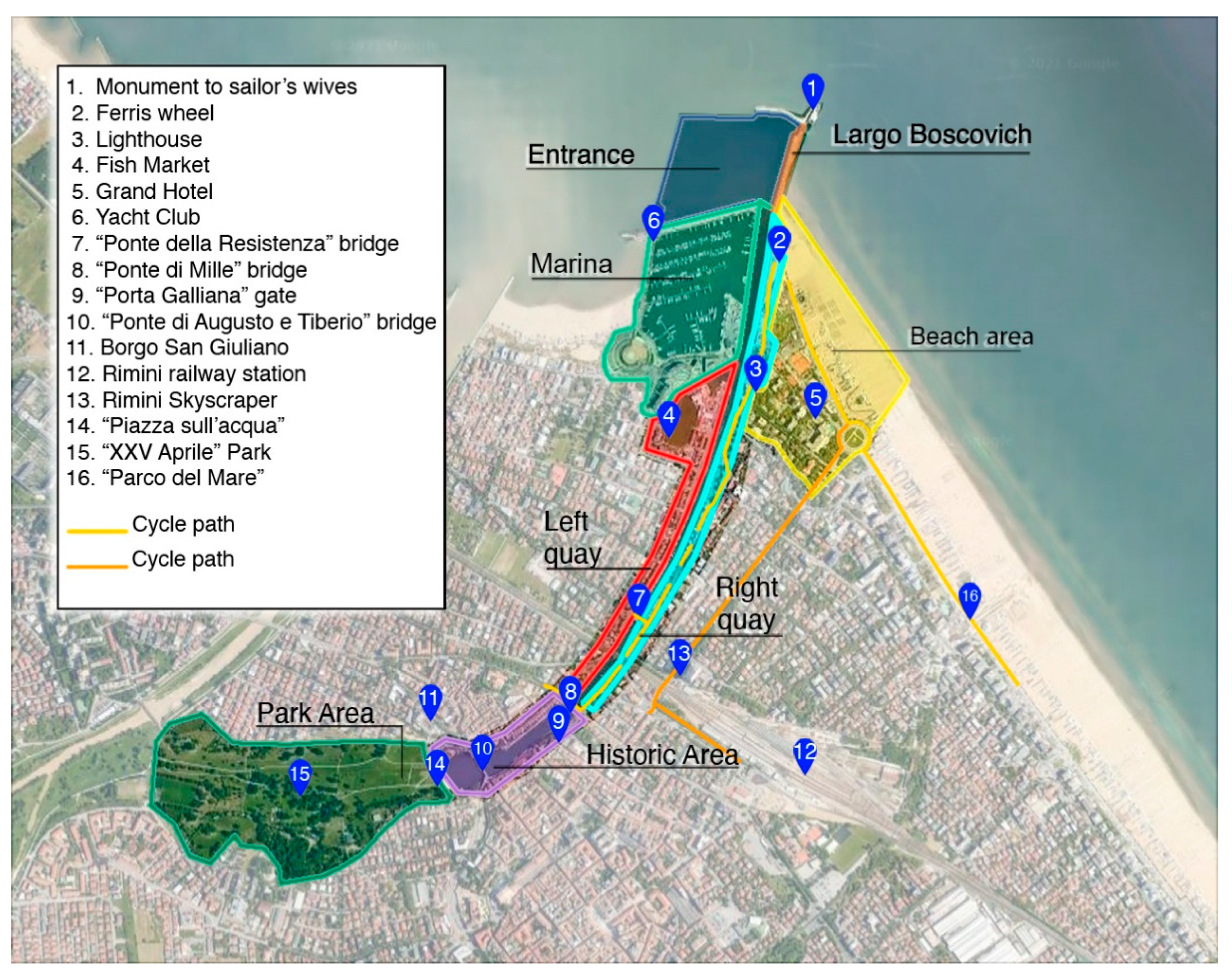
Abstract
:1. Introduction
- Reduced pollutant emissions;
- Increased active mobility of people;
- Increased use of public spaces;
- Reduction of urban and social degradation phenomena;
- Increased local tourism.
2. Data Collection
2.1. Case Study Description and Analysis
2.2. Analysis of Historic–Documentary Sources and Urban Regulations
2.3. Analysis of the Mobility System
3. Data Processing and Evaluations
3.1. SWOT Analysis
3.2. Stakeholders’ Involvement
- Trips with private motorized vehicles are safe and the infrastructures are on average perceived as satisfactory, but there are considerable inconveniences due to traffic.
- Traveling by public transport is considered safe, but shortcomings in intramodality have emerged.
- The cycle/pedestrian paths are generally well-lit and signposted and are perceived as being generally safe, but scarce shade has been reported, and in general, they are considered to be not completely adequate to the needs of cyclists and pedestrians.
- The parking lots were evaluated very negatively in almost every aspect investigated. Particular issues that emerged the scarcity of available lots and the amount of time needed to find a parking lot.
- The public spaces generally meet the expectations of the stakeholders in the aspects of lighting and safety, but some unsatisfactory elements remain, such as the scarce presence of green and urban furniture, the ineffective integration of the Canal Port area with the urban landscape of Rimini, poor cleaning and maintenance, and the presence of architectural barriers.
- The water quality of the Canal is considered very low due to dirt and the lack of water recirculation.
3.3. Multi-Criteria Analysis
- Benefits and Costs are measured at present time.
- Opportunities and Risks are estimated on the basis of expectations of the impacts of the intervention in the long term.
- Option 0: maintaining the current configuration of the Canal Port area. i.e., the no-intervention option;
- Option 1: creation of urban spaces of better quality;
- Option 2: implementation of the “Traghetto Vittoria” ferry service;
- Option 3: construction of a new interchange car park;
- Option 4: reconnection of cycle and pedestrian paths;
- Option 5: redevelopment and raising of docks;
- Option 6: construction of the new Fish Market;
- Option 7: construction of new tourist connections;
- Option 8: redevelopment of the slipway.
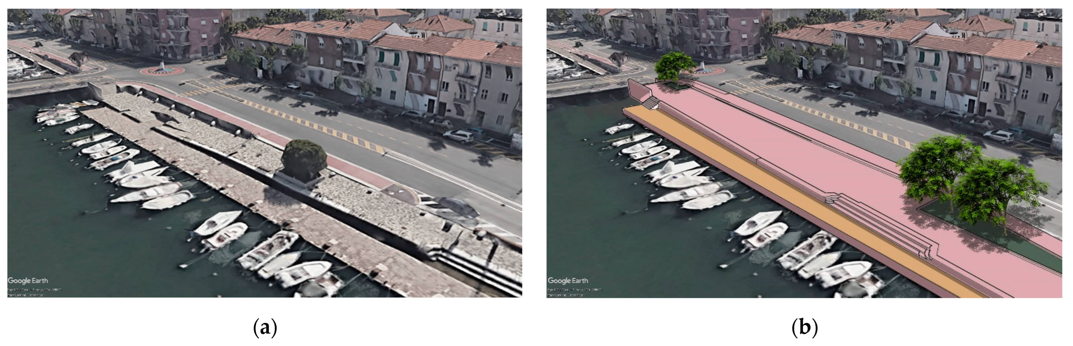
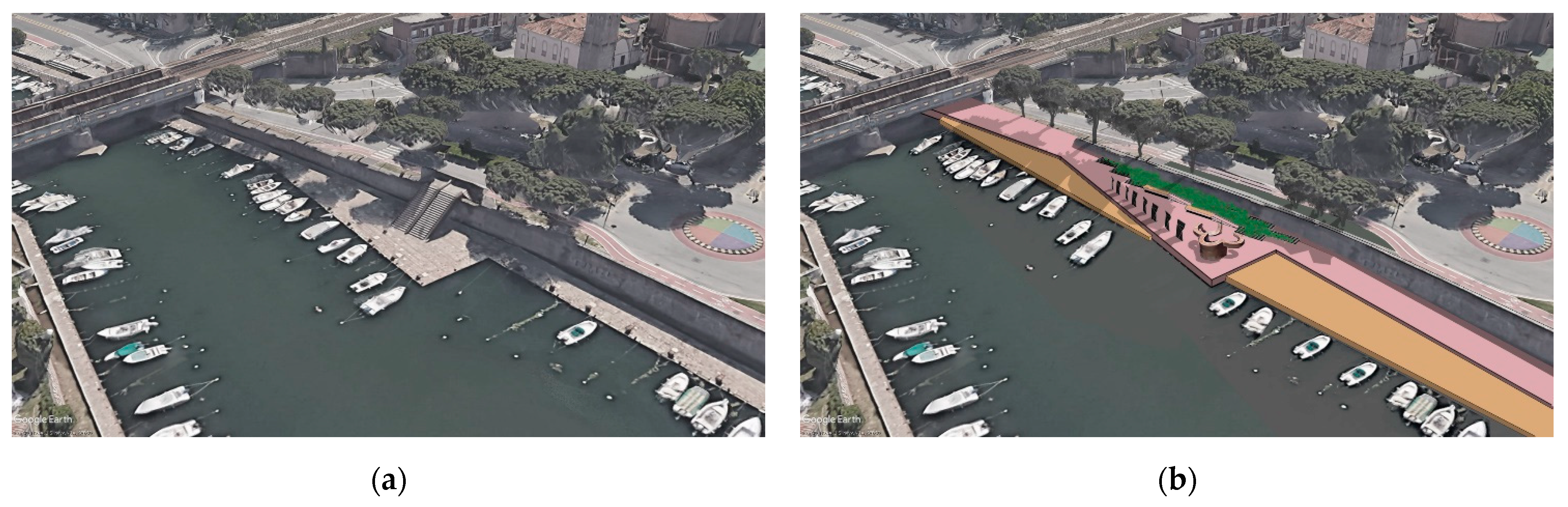
4. Urban Regeneration Project
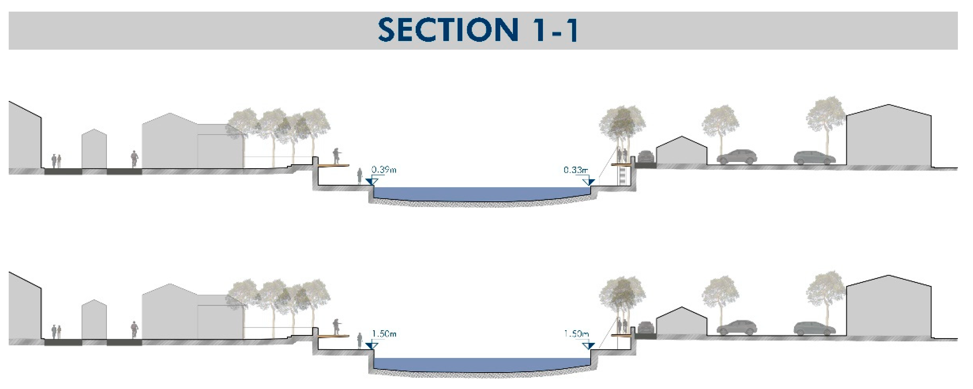
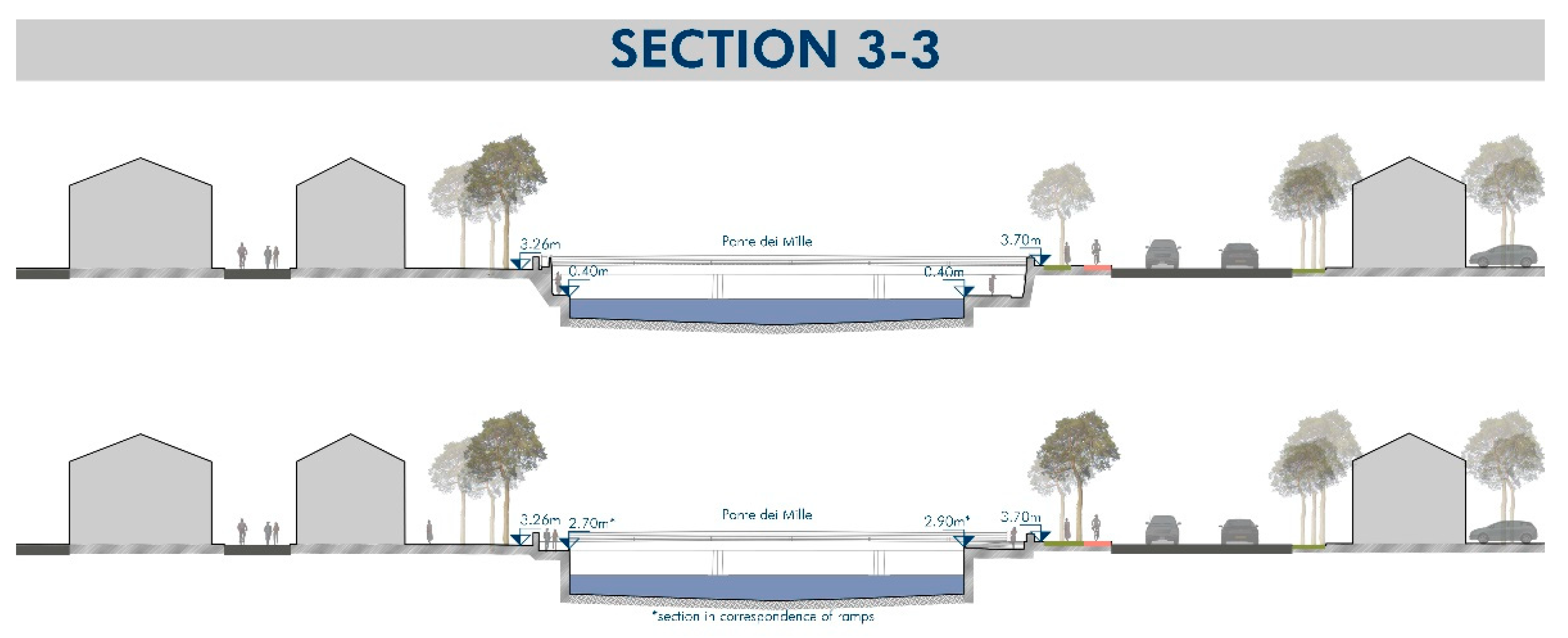
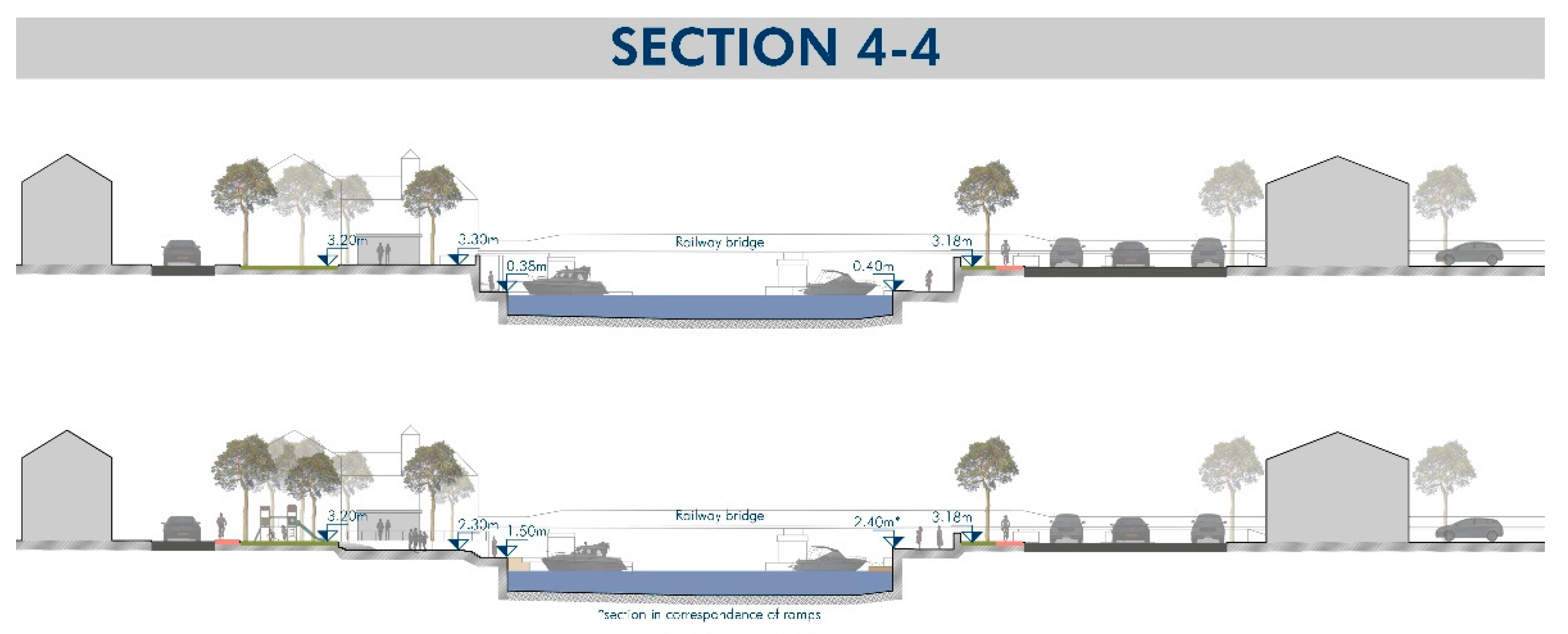
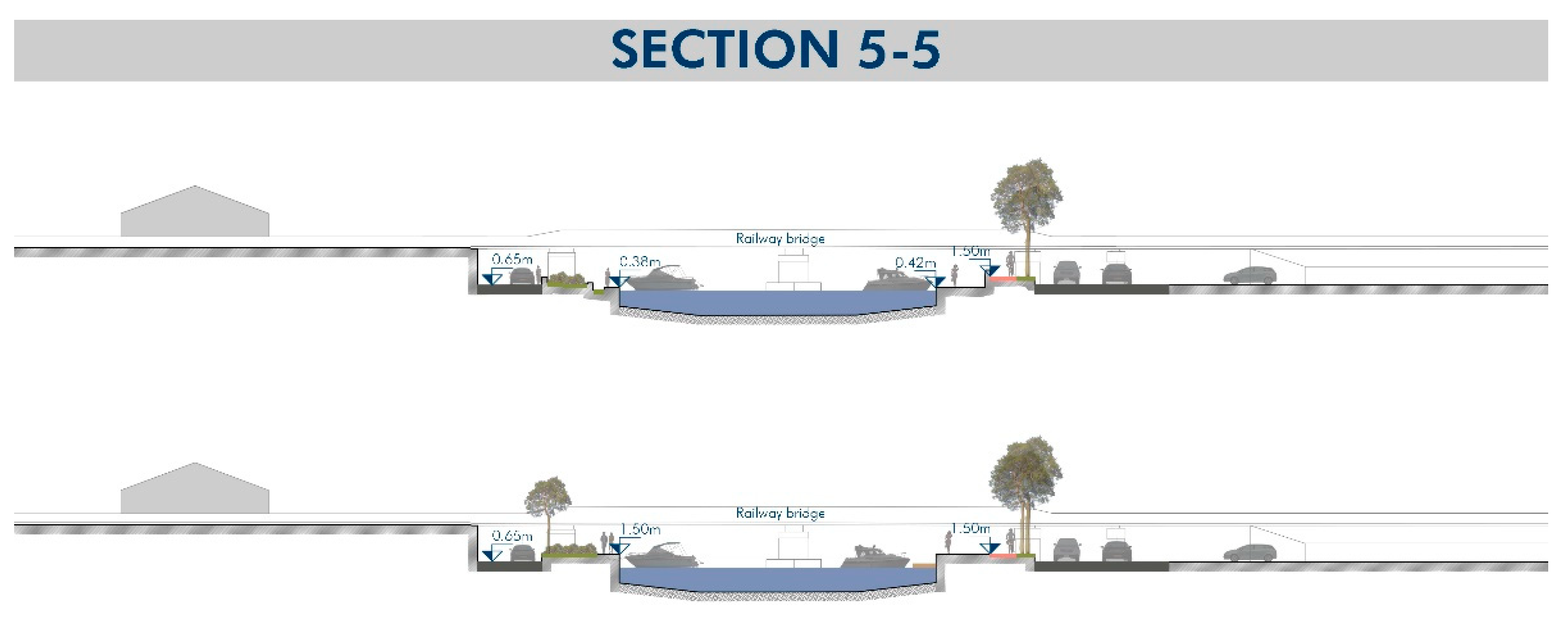
4.1. Identification of the Raising Height
4.2. Study of Critical Sections
- Raised dock at an elevation of 1.50 m above sea level; the dock would be raised entirely and there is no access for boats.
- Raised dock at an elevation of 1.00 m above sea level: the strip of quay closest to the edge of the canal would remain at an intermediate level between the current level and 1.50 m to allow access to boats. It is possible that this strip will be submerged at times during the year, but less frequently than at present.
- Floating platform: in those sections where it is not possible to dedicate a strip of the quay to mooring access, it is proposed to install floating platforms made of medium-density polyethylene anchored to the quay by means of steel brackets. These platforms move vertically along the steel guides following the free surface of the water.
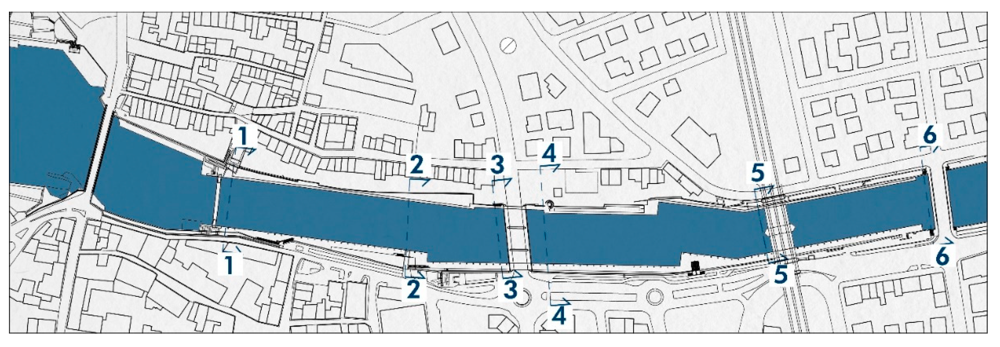
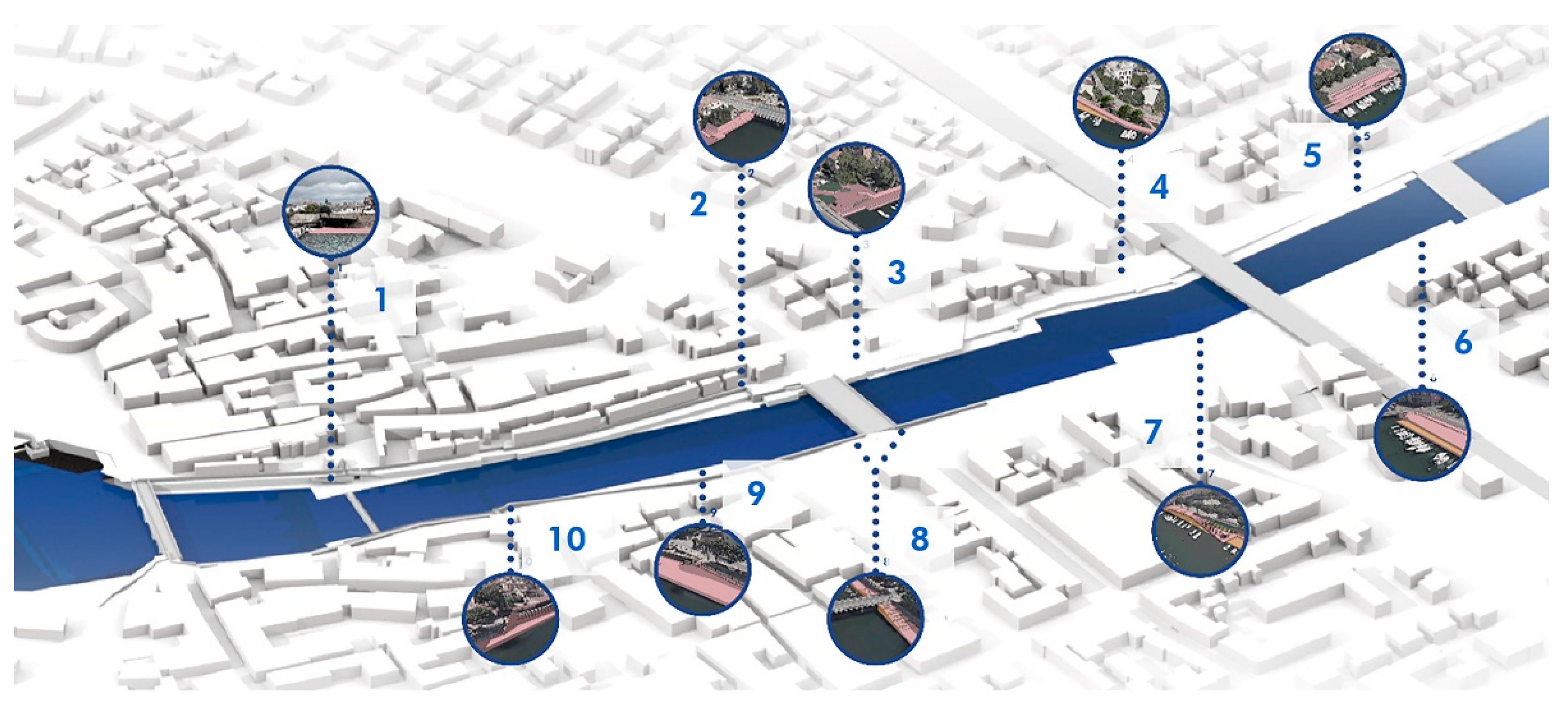
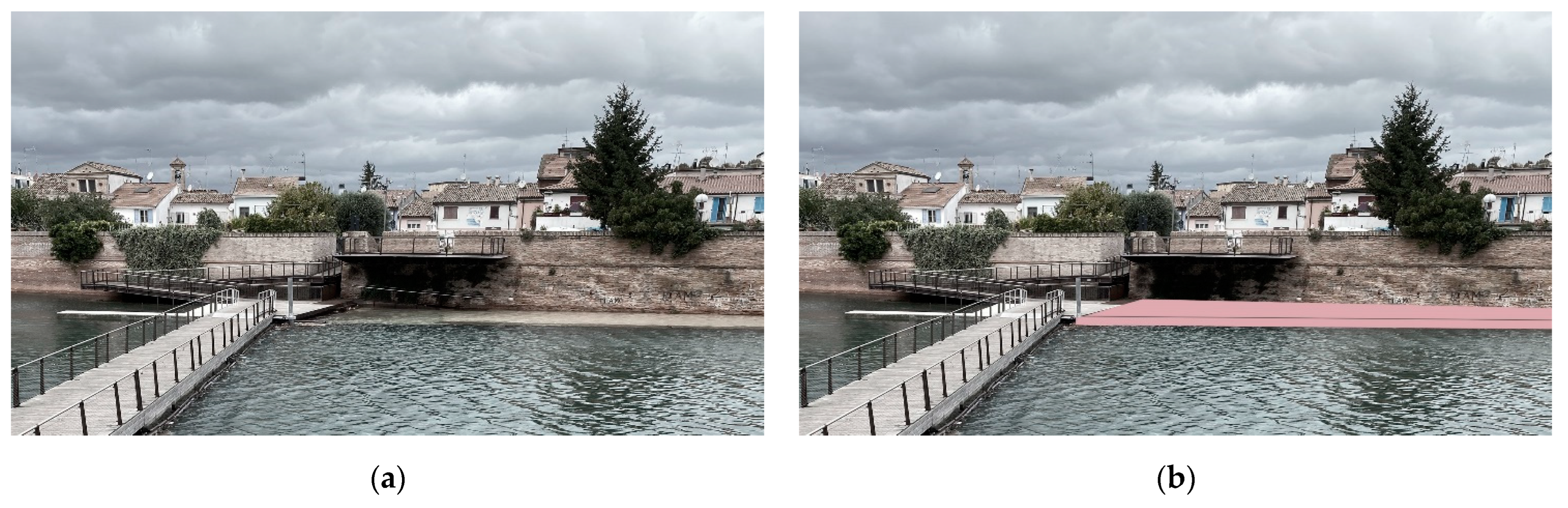
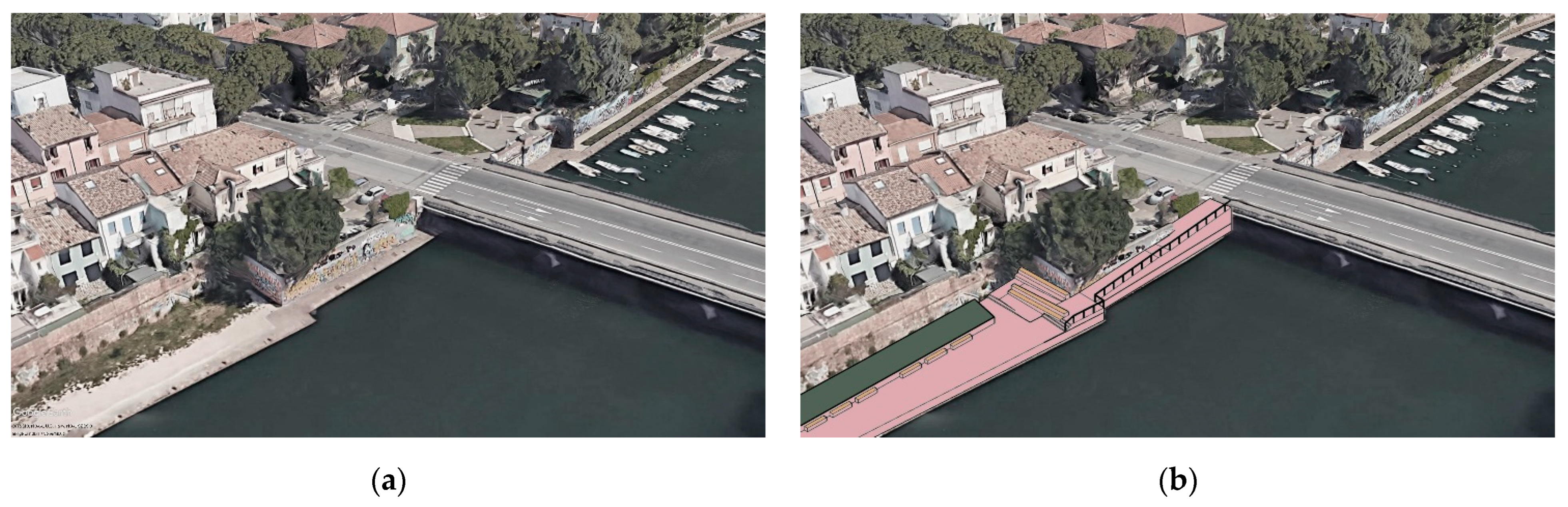
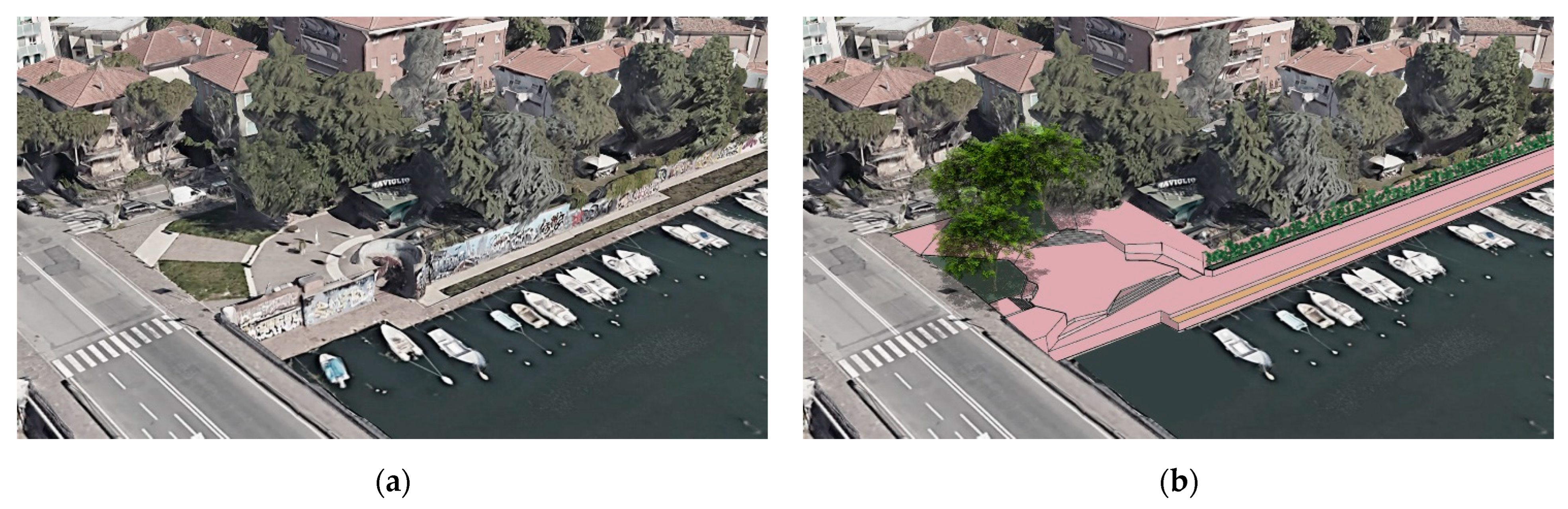
4.3. Design of Dock Access Ramps
- Access 1: ramp at the mobile pedestrian footbridge nearby the panoramic terrace;
- Access 2: at Ponte dei Mille besides the Chinese Restaurant “Fiore di Loto”;
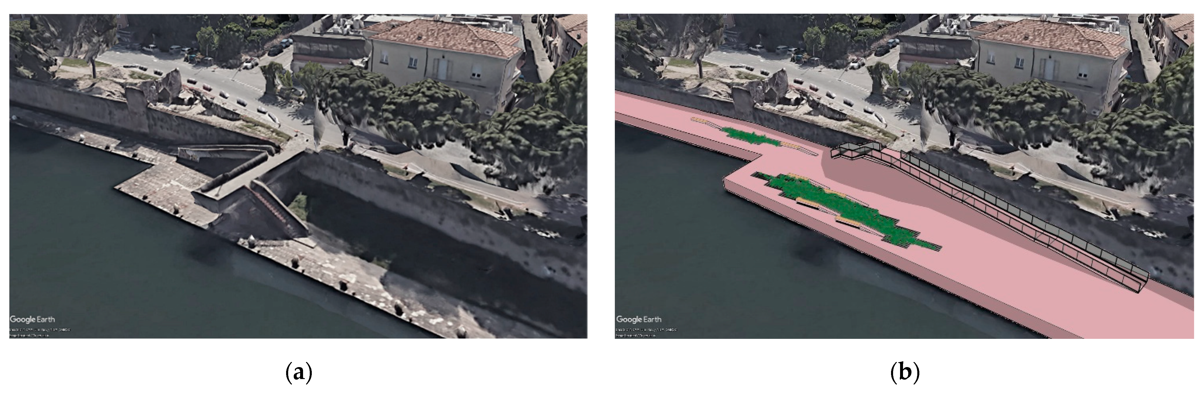
- Access 3: through the Giardini Don Luigi Sturzo;
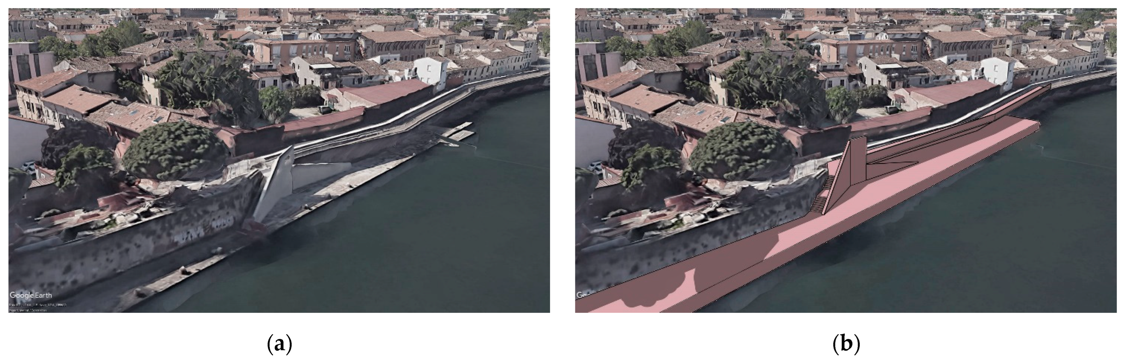
- Access 4: connection between Via Madonna della Scala and the docks at the Railway Bridge;
- Access 5: at Ponte della Resistenza, between Via E. Coletti and Via Sinistra del Porto;
- Access 6: at Ponte della Resistenza, between Via E. Coletti and Via Destra del Porto;
- Access 7: connection between Via G. Savonarola and the quay at the Railway Bridge;
- Access 8: new access to be realised to connect the docks to the Ponte dei Mille;
- Access 9: through the panoramic terrace near Porta Galliana;
- Access 10: in Via Bastioni Settentrionali, at the entrance to the cycle/pedestrian path.
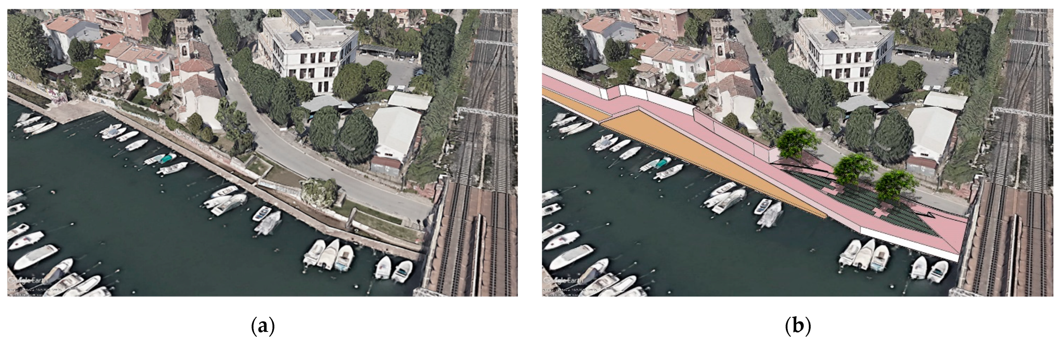
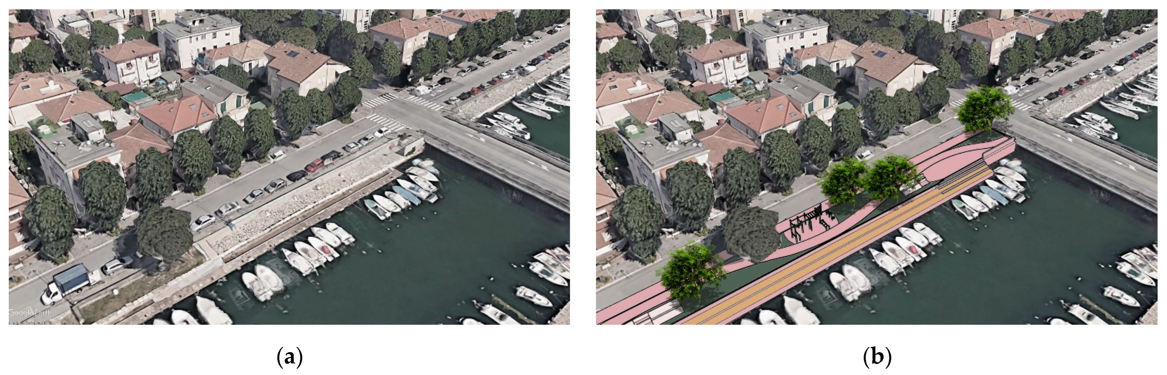
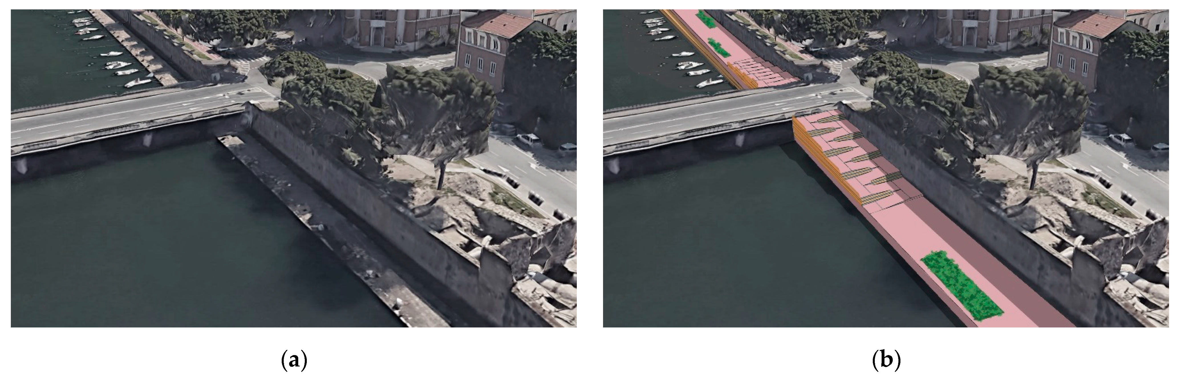
4.3.1. Access 1
4.3.2. Access 2
4.3.3. Access 3
4.3.4. Access 4
4.3.5. Access 5
4.3.6. Access 6
4.3.7. Access 7
4.3.8. Access 8
4.3.9. Access 9
4.3.10. Access 10
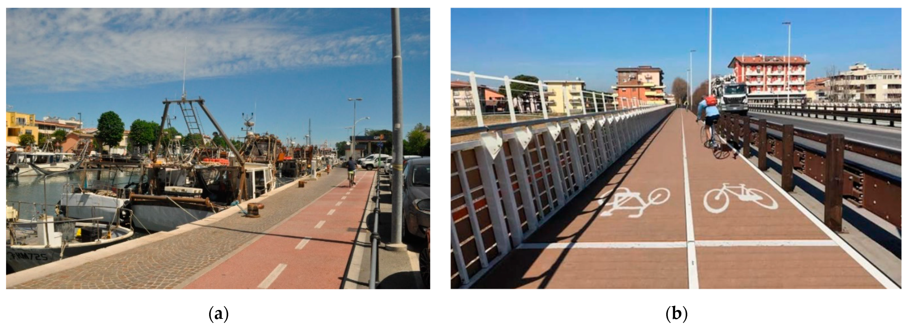
4.4. Cycle Paths
- In green, the existing cycle path along Via Destra del Porto, part of the so-called “green ring”.
- In yellow, the 30 km/h zone in Borgo San Giuliano.
- In blue, the new cycle/pedestrian path on the regenerated quay.
- In red, the new cycle path from Via Madonna della Scala to Via Sinistra del Porto.
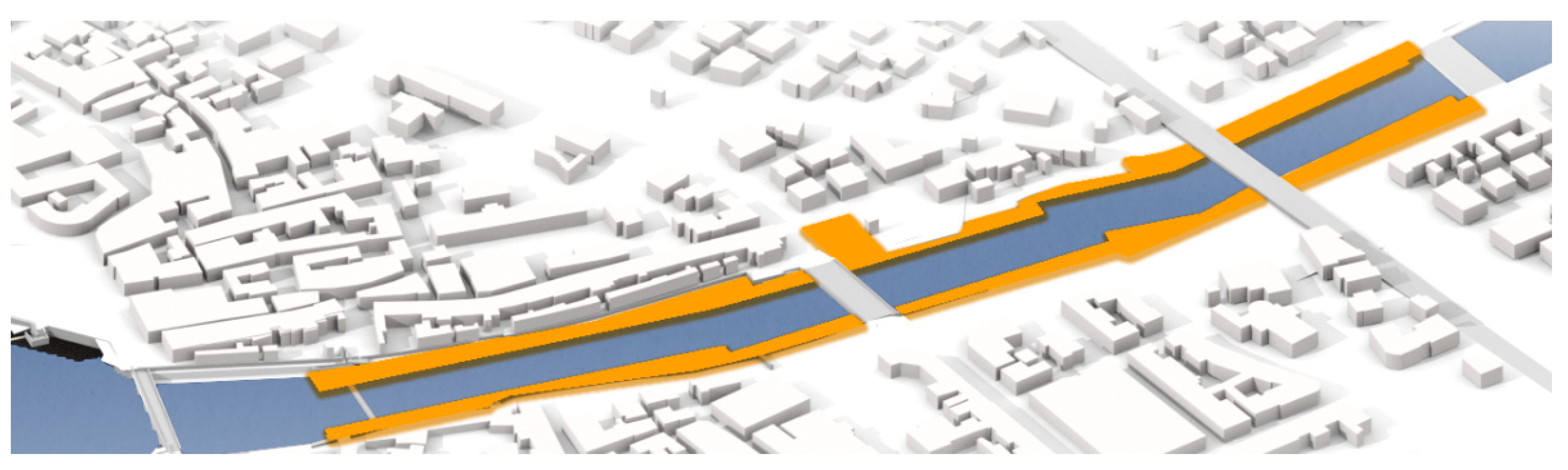
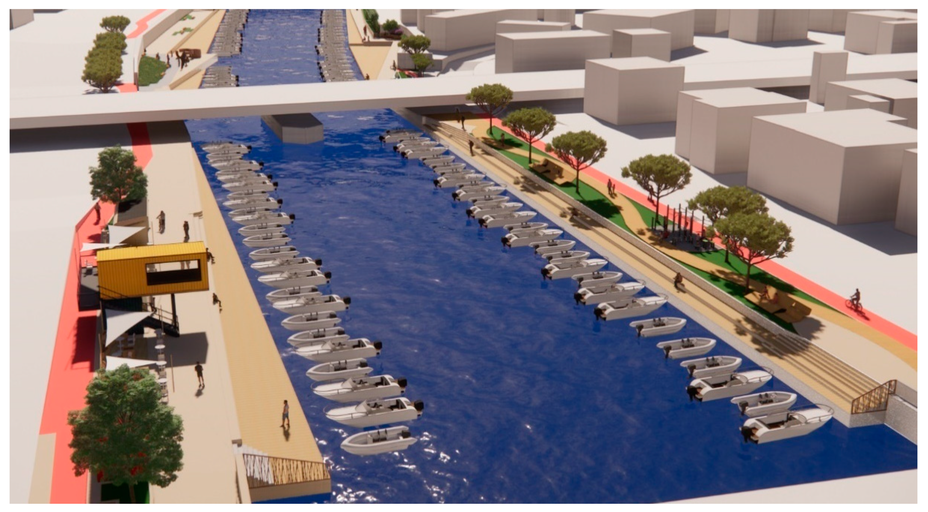
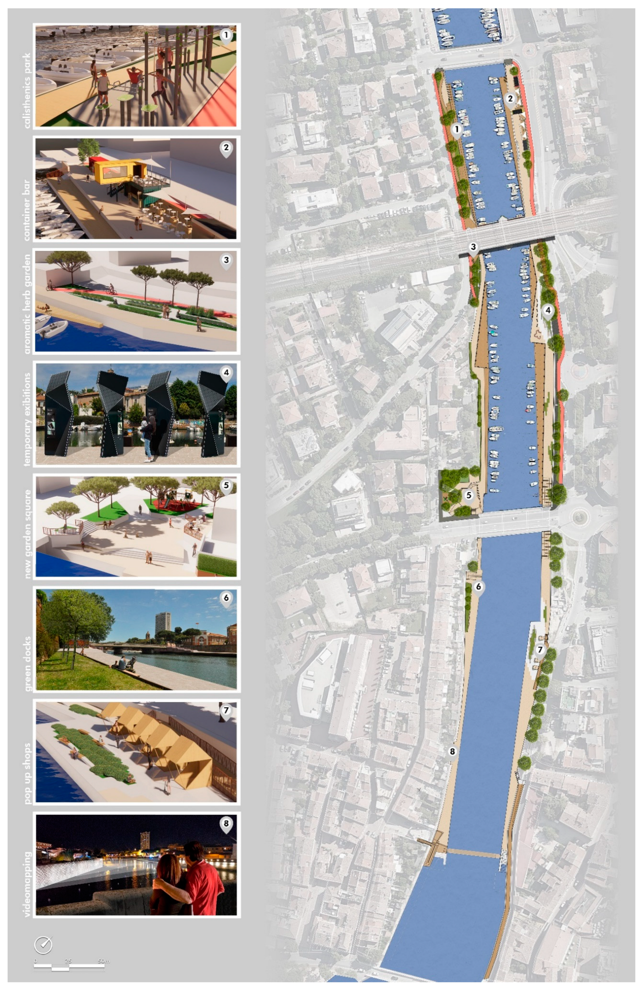
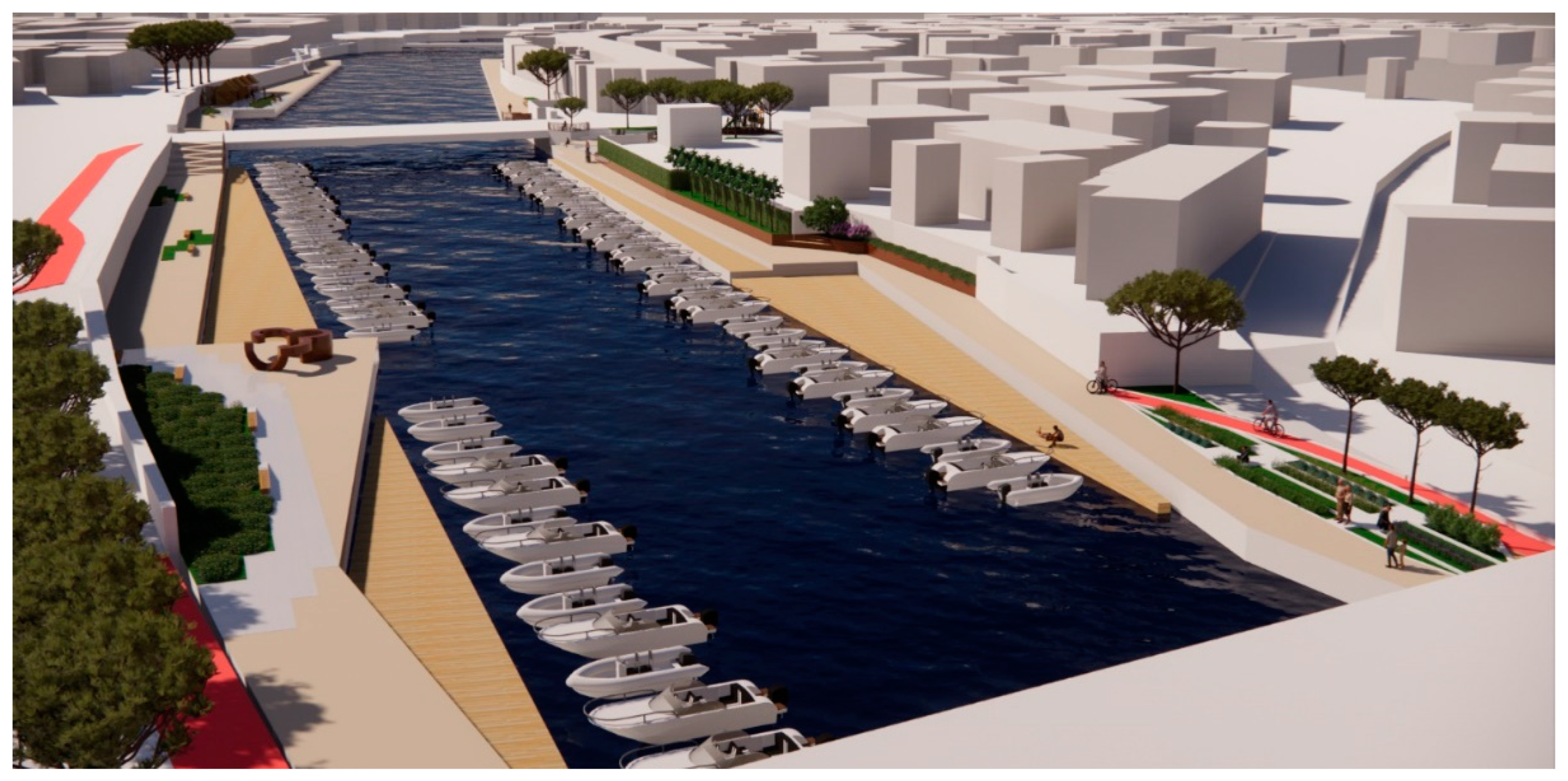
4.5. Masterplan
5. Discussion and Concluding Remarks
- A SWOT matrix (Strengths—Weaknesses—Opportunities—Threats) based on the results of the preliminary analysis delivered in the first phase;
- in-depth analysis of criticalities and potentials identified by the dialogue with involved stakeholders;
- the creation of a set of significant indicators for the assessment of the urban and infrastructural quality of the Canal Port area;
- BOCR analysis (Benefits—Opportunities—Costs—Risks) based on the selected set of indicators and identification of the priority scale of the interventions to be carried out for the redevelopment of the Canal Port area.
- improved aesthetic quality of urban spaces;
- improved environmental quality of urban spaces;
- reduction of pollutant emissions through the increase in green and permeable areas;
- increased user flow (residents and tourists) in areas that are currently poorly frequented;
- increased social well-being of the regenerated area.
Author Contributions
Funding
Acknowledgments
Conflicts of Interest
References
- A European Green Deal. Available online: https://ec.europa.eu/info/strategy/priorities-2019-2024/european-green-deal_en (accessed on 4 August 2022).
- The EU Strategy on Green Infrastructure. Available online: https://ec.europa.eu/environment/nature/ecosystems/strategy/index_en.htm (accessed on 4 August 2022).
- Interreg Italy-Croatia. Available online: https://www.italy-croatia.eu/ (accessed on 4 August 2022).
- FRAMESPORT–FRAMEwork Initiative Fostering the Sustainable Development of Adriatic Small PORTs. Available online: http://www.corila.it/it/node/328 (accessed on 4 August 2022).
- Ferrante, A. Towards Nearly Zero Energy. Urban Settings in the Mediterranean Climate; Elsevier Ltd.: Oxford, UK, 2016; ISBN 978-0-08-100735-8. [Google Scholar]
- Conticelli, E.; Bruni, E.; Tondelli, S. Pedestrian Mobility as Urban Regeneration Strategy. In Pedestrians, Urban Spaces and Health; CRC Press: Boca Raton, FL, USA, 2020. [Google Scholar]
- La Rocca, R.A. Soft Mobility and Urban Transformation. TeMA-J. Land Use Mobil. Environ. 2010, 2, 85–90. [Google Scholar] [CrossRef]
- Cramer, M. Soft Mobility-Measures for a Climate-Friendly Transport Policy in Europe; The Greens: Brussels, Belgium, 2009. [Google Scholar]
- Sustrans. Available online: https://www.sustrans.org.uk/ (accessed on 4 August 2022).
- Turner, T. Greenways, Blueways, Skyways and Other Ways to a Better London. Landsc. Urban Plan. 1995, 33, 268–282. [Google Scholar] [CrossRef]
- Valente, R.; Mozingo, L.; Bosco, R.; Cappelli, E.; Donadio, C. Environmental Regeneration Integrating Soft Mobility and Green Street Networks: A Case Study in the Metropolitan Periphery of Naples. Sustainability 2021, 13, 8195. [Google Scholar] [CrossRef]
- “Alps Mobility” EU Interreg III B Alpine Space Programme. Available online: https://www.alpine-space.org/2000-2006/index-2.html (accessed on 4 August 2022).
- Pazzini, M.; Lantieri, C.; Vignali, V.; Simone, A. Innovative Methodologies to Evaluate Project Scenarios on Cycle-Pedestrian Networks. In Proceedings of the Sustainable Pavements and Road Materials, Naples, Italy, 9 September 2022; Federico II University Press: Naples, Italy, 2022. [Google Scholar]
- Pellicelli, G.; Rossetti, S.; Caselli, B.; Zazzi, M. Urban Regeneration as an Opportunity to Redesign Sustainable Mobility. Experiences from the Emilia-Romagna Regional Call. Transp. Res. Procedia 2022, 60, 576–583. [Google Scholar] [CrossRef]
- World Summit on Sustainable Development (WSSD). Available online: https://sustainabledevelopment.un.org/milesstones/wssd (accessed on 4 August 2022).
- Ferrante, A.; Fotopoulou, A.; Mazzoli, C. Sustainable Urban Regeneration through Densification Strategies: The Kallithea District in Athens as a Pilot Case Study. Sustainability 2020, 12, 9462. [Google Scholar] [CrossRef]
- Transforming Our World: The 2030 Agenda for Sustainable Development. Available online: https://sdgs.un.org/2030agenda (accessed on 4 August 2022).
- Pontrandolfi, P.; Scorza, F. Sustainable Urban Regeneration Policy Making: Inclusive Participation Practice. In Proceedings of the Lecture Notes in Computer Science, Beijing, China, 4–7 July 2016; pp. 552–560. [Google Scholar]
- Bottero, M.; Ferretti, V. An Analytic Network Process-Based Approach for Location Problems: The Case of a New Waste Incinerator Plant in the Province of Torino (Italy). J. Multi-Criteria Decis. Anal. 2011, 17, 63–84. [Google Scholar] [CrossRef] [Green Version]
- Bottero, M.; Mondini, G.; Oppio, A. Decision Support Systems for Evaluating Urban Regeneration. Procedia-Soc. Behav. Sci. 2016, 223, 923–928. [Google Scholar] [CrossRef] [Green Version]
- Broto, V.C.; Boyd, E.; Ensor, J. Participatory Urban Planning for Climate Change Adaptation in Coastal Cities: Lessons from a Pilot Experience in Maputo, Mozambique. Curr. Opin. Environ. Sustain. 2015, 13, 11–18. [Google Scholar] [CrossRef] [Green Version]
- Maretto, M. Il Progetto Urbano Sostenibile; Franco Angeli: Milano, Italy, 2020; ISBN 978-88-351-0704-0. [Google Scholar]
- Legge Regionale 21 Dicembre 2017, n. 24. Disciplina Regionale Sulla Tutela e l’uso Del Territorio. Available online: https://territorio.regione.emilia-romagna.it/codice-territorio/pianif-territoriale/legge-regionale-21-dicembre-2017-n-24 (accessed on 4 August 2022).
- Pianificazione Urbanistica Generale (PUG). Available online: https://www.comune.rimini.it/servizi/catasto-e-urbanistica/pianificazione-urbanistica-generale (accessed on 4 August 2022).
- Piano Urbano Della Mobilità Sostenibile (PUMS). Available online: https://www.comune.rimini.it/documenti/pums-piano-urbano-della-mobilita-sostenibile-adozione (accessed on 4 August 2022).
- Nuova Pista Ciclabile via Coletti. Available online: http://archivio.comune.rimini.it/archivio-notizie/nuova-ciclabile-di-oltre-800-metri-sulla-via-coletti (accessed on 4 August 2022).
- Pazzini, M.; Cameli, L.; Lantieri, C.; Vignali, V.; Dondi, G.; Jonsson, T. New Micromobility Means of Transport: An Analysis of E-Scooter Users’ Behaviour in Trondheim. Int. J. Environ. Res. Public Health 2022, 19, 7374. [Google Scholar] [CrossRef]
- Legge 25 Febbraio 2022, n. 15. Available online: https://www.normattiva.it/uri-res/N2Ls?urn:nir:stato:legge:2022-02-25;15 (accessed on 4 August 2022).
- Pazzini, M.; Lantieri, C.; Vignali, V.; Simone, A.; Dondi, G.; Luppino, G.; Grasso, D. Case Studies in the Emilia Romagna Region in Support of Intermodality and Accessibility of Public Transport. In Advances in Mobility-as-a-Service Systems; Springer: Berlin/Heidelberg, Germany, 2021; Volume 1278, pp. 65–74. [Google Scholar]
- Bottero, M. A Multi-Methodological Approach for Assessing Sustainability of Urban Projects. Manag. Environ. Qual. 2015, 26, 138–154. [Google Scholar] [CrossRef]
- Garcia, S.M.; Staples, D.J.; Chesson, J. The FAO Guidelines for the Development and Use of Indicators for Sustainable Development of Marine Capture Fisheries and an Australian Example of Their Application. Ocean. Coast. Manag. 2000, 43, 537–556. [Google Scholar] [CrossRef]
- Casamassima, C. Strumenti e Metodi Di Analisi e Progettazione per La Rigenerazione Urbana Delle Aree Portuali: Il Caso Del Porto Canale Di Rimini. Master’s Thesis, University of Bologna, Bologna, Italy, 2022. [Google Scholar]
- Bottero, M.; Ferretti, V.; Pomarico, S. Assessing the Sustainability of Alternative Transport Infrastructures. Int. J. Anal. Hierarchy Process 2012, 4. [Google Scholar] [CrossRef]
- Bottero, M.; D’Alpaos, C.; Oppio, A. Multicriteria Evaluation of Urban Regeneration Processes: An Application of PROMETHEE Method in Northern Italy. Adv. Oper. Res. 2018, 2018, 9276075. [Google Scholar] [CrossRef] [Green Version]
- Pazzini, M.; Lantieri, C.; Vignali, V.; Simone, A.; Dondi, G.; Luppino, G.; Grasso, D. Comparison between Different Territorial Policies to Support Intermodality of Public Transport. Transp. Res. Procedia 2022, 60, 68–75. [Google Scholar] [CrossRef]
- Munda, G. Social Multi-Criteria Evaluation: Methodological Foundations and Operational Consequences. Eur. J. Oper. Res. 2004, 158, 662–677. [Google Scholar] [CrossRef]
- Myrtveit, I.; Stensrud, E.; Shepperd, M. Reliability and Validity in Comparative Studies of Software Prediction Models. IEEE Trans. Softw. Eng. 2005, 31, 380–391. [Google Scholar] [CrossRef] [Green Version]
- Bottero, M.; Lami, I.; Lombardi, P.L. Analytic Network Process. La Valutazione Di Scenari Di Trasformazione Urbana e Territoriale; Alinea Editrice: Firenze, Italy, 2008; ISBN 978-88-6055-315-7. [Google Scholar]
- Saaty, T.L.; Vargas, L.G. The Analytic Network Process. In Decision Making with the Analytic Network Process; Operations Research & Management Science; Springer: Boston, MA, USA, 2013; Volume 195, pp. 1–40. [Google Scholar] [CrossRef]
- Saaty, T.L. Decision Making with the Analytic Hierarchy Process. Int. J. Serv. Sci. 2008, 1, 83–98. [Google Scholar] [CrossRef] [Green Version]
- Saaty, T.L. The Analytic Hierarchy Process; McGraw Hill: New York, NY, USA, 1980. [Google Scholar]
- Saaty, T.L. Theory and Applications of the Analytic Network Process: Decision Making with Benefits, Opportunities, Costs, and Risks; RWS Publications: Pittsburgh, PA, USA, 2005; ISBN 978-1-888603-06-4. [Google Scholar]
- Saaty, T.L. Fundamentals of the Analytic Network Process—Multiple Networks with Benefits, Costs, Opportunities and Risks. J. Syst. Sci. Syst. Eng. 2004, 13, 348–379. [Google Scholar] [CrossRef]
- CESI. Progetto Idraulico Del Parco Marecchia e Sistemazione Del Porto Canale Di Rimini; Comune di Rimini: Rimini, Italy, 2006. [Google Scholar]
- Skayannis, P.; Goudas, M.; Rodakinias, P. Sustainable Mobility and Physical Activity: A Meaningful Marriage. Transp. Res. Procedia 2017, 27, 81–88. [Google Scholar] [CrossRef]
- Carta Della Tutela Monumentale, Tavola C.1.1.4., PSC, Rimini. 2019. Available online: https://www.comune.rimini.it/sites/default/files/2021-06/C_1_1_4.pdf (accessed on 5 August 2022).
- Decreto Del Ministro Dei Lavori Pubblici 14 Giugno 1989, n. 236; Gazzetta Ufficiale: Rome, Italy, 1989.
- Gehl, J. Cities for People; Island Press: Washington, DC, USA, 2010; ISBN 978-1-59726-573-7. [Google Scholar]
- Legge Regionale 05 Giugno 2017, n. 10: Linee Guida per Il Sistema Regionale Della Ciclabilità. Available online: https://mobilita.regione.emilia-romagna.it/allegati/convegni_presentazioni/2019/mag2019_lineeguidaciclabilita/lineeguidaciclabilita_allegato1.pdf/@@download/file/lineeguidaciclabilita_allegato1.pdf (accessed on 4 August 2022).
- Linee Guida per La Progettazione Di Interventi Su Strade, Piazze Ed Infrastrutture Ad Esse Connesse; Comune di Bologna Guida Progettuale: Bologna, Italy, 2009; Available online: http://atti9.comune.bologna.it/atti/wpub_delibere.nsf/%24%24OpenDominoDocument.xsp?documentId=40D9DAB4AB92AD93C12587B9003FA60B&action=openDocument (accessed on 5 August 2022).
- Kelbaugh, D. Common Place: Toward Neighborhood and Regional Design; University of Washington Press: Seattle, WA, USA, 1997; ISBN 0-295-97590-3. [Google Scholar]
- Heesch, K.C.; James, B.; Washington, T.L.; Zuniga, K.; Burke, M. Evaluation of the Veloway 1: A natural experiment of new bicycle infrastructure in Brisbane, Australia. J. Transp. Health 2016, 3, 366–376. [Google Scholar] [CrossRef] [Green Version]
- Zahabi, S.A.H.; Chang, A.; Miranda-Moreno, L.F.; Patterson, Z. Exploring the link between the neighborhood typologies, bicycle infrastructure and commuting cycling over time and the potential impact on commuter GHG emissions. Transp. Res. Part D Transp. Environ. 2016, 47, 89–103. [Google Scholar] [CrossRef]
- Yang, Q.; Cai, J.; Feng, T.; Liu, Z.; Timmermans, H. Bikeway Provision and Bicycle Commuting: City-Level Empirical Findings from the US. Sustainability 2021, 13, 3113. [Google Scholar] [CrossRef]
- Piras, F.; Scappini, B.; Meloni, I. The transformation of urban spaces as a cycling motivator: The case of Cagliari, Italy. Transp. Res. Procedia 2022, 60, 60–67. [Google Scholar] [CrossRef]


Publisher’s Note: MDPI stays neutral with regard to jurisdictional claims in published maps and institutional affiliations. |
© 2022 by the authors. Licensee MDPI, Basel, Switzerland. This article is an open access article distributed under the terms and conditions of the Creative Commons Attribution (CC BY) license (https://creativecommons.org/licenses/by/4.0/).
Share and Cite
Corticelli, R.; Pazzini, M.; Mazzoli, C.; Lantieri, C.; Ferrante, A.; Vignali, V. Urban Regeneration and Soft Mobility: The Case Study of the Rimini Canal Port in Italy. Sustainability 2022, 14, 14529. https://doi.org/10.3390/su142114529
Corticelli R, Pazzini M, Mazzoli C, Lantieri C, Ferrante A, Vignali V. Urban Regeneration and Soft Mobility: The Case Study of the Rimini Canal Port in Italy. Sustainability. 2022; 14(21):14529. https://doi.org/10.3390/su142114529
Chicago/Turabian StyleCorticelli, Rachele, Margherita Pazzini, Cecilia Mazzoli, Claudio Lantieri, Annarita Ferrante, and Valeria Vignali. 2022. "Urban Regeneration and Soft Mobility: The Case Study of the Rimini Canal Port in Italy" Sustainability 14, no. 21: 14529. https://doi.org/10.3390/su142114529