From Herding to Farming under Adaptation Interventions in Southern Kenya: A Critical Perspective


1
Department of Human Geography and Planning, Utrecht University, 3584 CB Utrecht, The Netherlands
2
Earth and Life Institute, Université Catholique de Louvain, 1348 Louvain-la-Neuve, Belgium
*
Author to whom correspondence should be addressed.
Sustainability 2018, 10(12), 4386; https://doi.org/10.3390/su10124386
Submission received: 30 September 2018
/
Revised: 15 November 2018
/
Accepted: 16 November 2018
/
Published: 23 November 2018
(This article belongs to the Special Issue Beyond Beneficiaries: Conflict and Climate Change Adaptation Interventions in African Drylands)
Abstract
:Improving water supply for irrigable farming and livestock purposes in communities in Africa is an increasingly popular approach for community-based adaptation interventions. A widespread intervention is the construction of agro-pastoral dams and irrigation schemes in traditionally pastoral communities that face a drying climate. Taking the Maji Moto Maasai community in southern Kenya as a case study, this article demonstrates that water access inequality can lead to a breakdown of pre-existing social capital and former pastoral cooperative structures within a community. When such interventions trigger new water uses, such as farming in former pastoral landscapes, there are no traditional customary institutional structures in place to manage the new water resource. The resulting easily corruptible local water management institutions are a main consolidator of water access inequalities for intervention beneficiaries, where socio-economic standing often determines benefits from interventions. Ultimately, technological adaptation interventions such as agro-pastoral dams may result in tensions and a high fragmentation of adaptive capacity within target communities.
1. Introduction
In the drylands of southern Kenya, water is a seasonally scarce resource for many rural people. Seasonal water scarcity has been increasing in many of its areas for the past five decades, which is primarily driven by a rise in water demand as a consequence of population growth and loss of access to dry season water areas caused, amongst others, by sedentarization of previously mobile pastoralists and the privatization of formerly common lands [1,2]. Water scarcity in the dry season is worsened by a drying climate; not necessarily because precipitation has become lower, but more because temperature has increased, which raises evapotranspiration rates and eventually lowers the moisture balance [3]. The need to adapt to climate change, that is, to manage the impacts of climate change by reducing vulnerability and exposure to its harmful effects and exploiting any potential benefits [4], has therefore become ever more important for rural communities in southern Kenya. In dryland areas, water is not only increasingly seasonally scarce, but also more and more contested. Competing claims between user groups (farmers, agro-pastoralists and pastoralists) relying on similar land and water sources is seen as a source of conflict [5,6]. Local conflict may erupt because pastoralists and their cattle, while trying to access a water source, destroy the agricultural fields of farmers. Such crop destruction, if not compensated properly, can be detrimental for the food security of farmers. Pastoralists can also compete with each other, as some undertake cattle raids on other pastoral groups as a means of building up their herds when droughts are expected to arrive—strengthening their adaptive capacity at the cost of others [7,8]. Conflicts can also take place between farmers themselves, especially over scarce irrigation water [9], often fuelled not only by rising water demand and overuse, but also due to weak water institutions [10].
Due to these and other adverse effects of water scarcity, creating water abundance and improving water access is a priority for climate change adaptation activities in sub-Saharan Africa. An increasingly popular approach to address the challenges of climate change at the local scale are the so-called community-based adaptation (CBA) interventions. These are adaptation projects deliberately designed and implemented to enhance the resilience of project beneficiaries to the impacts of climate change [11]. CBA approaches focus on communities as loci of adaptation actions and tend to stress that vulnerability to climatic change is largely a result of social and economic deficits. In addition, adaptive capacity is largely seen as a function of a society’s capacity to make informed and collective decisions in response to uncertain climatic changes [12].
Following the COP21 summit in Paris in December 2015, where increased funding for climate change adaptation efforts in sub-Saharan Africa was reaffirmed, implementation of many more of such interventions is very likely to continue in the near future. Such adaptation funding has triggered, and is likely to trigger, a plethora of CBA interventions aiming to increase water availability in the water-scarce areas of the developing world.
In the water sector, CBA interventions increasingly aim to combat water scarcity by installing communal water supplies such as agro-pastoral dams, dugouts, ponds, and boreholes. Such shared water sources can be classified as ‘common-pool water resources’ or CPWRs, as the water provided can be used collectively, while its usage is also rivalrous and generally difficult to exclude users from accessing it (after Reference [13]). Adaptation interventions that increase water availability by introducing CPWRs are already known to sometimes result in uneven water access, sometimes leading to tension and conflict. This has been demonstrated by Tänzler and Ruettinger [14], who observed that in Kasese, Uganda, after a beneficiary community was provided additional boreholes, tensions rose as a result of competing demands for the newly available water. In a sub-location of Kasese, the Rukoki area, a water tap was installed, which caused anger among people living in a neighbouring sub-location [15]. The Kasese example demonstrates that tensions between communities can be triggered by CBA interventions that establish CPWRs. However, tensions can also occur within villages or communities, when communities, under the umbrella of an externally-funded CBA intervention, are given the responsibility to govern a newly rehabilitated or constructed CPWR. Brown et al. [16] show how differential socio-economic statuses among farmers and pastoralists can lead to power inequalities, whereby those with higher socio-economic status and thus more power are able to informally influence water management institutions (through corruption for example), increasing their access to water at the cost of less powerful user groups, thus creating discontent and tensions between the two groups.
This article builds on these existing studies on the effects of CBA interventions targeting CPRWs. A case study is discussed in the drylands of southern Kenya, where an agro-pastoral dam and irrigation scheme were constructed under an adaptation intervention called the Maji Moto Community Water Project (MMCWP). While Maji Moto is historically a pastoral community where water was primarily used for livestock, the MMCWP resulted in water increasingly being used for crop farming. The analysis is done from a social capital perspective, meaning that the changes in strength of social relationships are examined within the studied community to provide a critical perspective on the impacts of the MMCWP on adaptive capacities. The article shows that while the MMCWP may have increased absolute water abundance for the community, it also triggered processes that led to very unequal water access. This contributed to an increase in socio-economic inequality, which in turn broke down pre-existing social capital and led to increasing tensions and local conflicts within the beneficiary community. Ultimately, the MMCWP caused fragmented enhancements in adaptive capacity, making such rather technological-oriented interventions—which are widespread—by no means inclusive or pro-poor. What makes the case of Maji Moto particularly compelling is that these water-related changes happened at a time when landownership was being devolved from the community to the family level. By examining how the effects of the CBA intervention articulated with these wider land-tenure transformations, the article demonstrates that individualization of land tenure increases water access inequalities and lowers effective CPWR use and management in formerly pastoral landscapes.
2. Theory
The adverse effects of water scarcity, such as conflict, are widely written about and adaptation interventions constitute a practical response to them. However, much less is known on the effects of newly created water abundances by these interventions, and how they relate to changes in social capital and water access within beneficiary communities. To understand these changes, this article combines an analysis of ‘bonding social capital’ with an examination of people’s perceptions on water access.
Social capital is often defined as relationships of trust, norms of reciprocity, and networks among individuals that can be drawn upon for individual or collective benefit [17,18,19]. Social capital can be expected to have a strong influence on adaptive capacity when using CPWRs: According to commons theory, strengthened social capital improves a group’s ability to come up with innovative solutions to problems, manage risks, and adapt to (climate) change [20,21,22]. In the context of climate change adaptation, high levels of social capital are therefore crucial for people’s adaptive capacity, as it enables cooperation in the use and management of climate-affected natural resources. Social capital is thus important for the collective management of natural resources because it fosters trust, social cohesion and cooperation between resource users within a community, or between communities. When trust and social cohesion increase, it is argued, social norms and social control are created which can form a solution against opportunistic, often called ‘free-rider’, behavior in using the shared resource—making collective action (i.e., cooperation) possible. This is especially the case for ‘bonding social capital’, which refers to the intra-communal ties that give families and communities a sense of identity and common purpose [22,23]. Bonding social capital is however not inherently positive for the collective management of a resource, as it can take on ‘perverse’ forms when exclusive alliances are formed by a section of a community that lead to the undermining of collective action within a community as a whole [24,25,26]. As such, bonding social capital can have an exclusionary function [21] and can result, for example, in the elite capture of a resource. Elite capture is often defined as a situation where resources designated for the benefit of the larger population are usurped by few individuals of superior status (corruption), be it economic, political, educational, ethnic or otherwise [27]. Elite capture of a communal resource can indeed be a consequence of perverse social capital, as elites tend to share high levels of social capital among themselves as an exclusive group within a community—at the cost of the resource use of the majority [21].
Our research examines changes in bonding social capital between the pre- and the post-intervention period. The possibility of bonding social capital to have an exclusionary function has been taken into account in the research design by looking at how different groups of water users perceive changes in water access. Previous studies have shown that unequal water access and perceptions thereof can exacerbate already existing tensions and/or make communities more prone to conflict [28,29,30,31,32]. To understand how adaptation interventions relate to changes in social capital, it is therefore important to incorporate an analysis of perceptions of (in)equality in water access. Water access is defined as “the ability to benefit from newly abundant water,” in line with Ribot and Peluso’s definition of access [33]. Added to the component of access is equality, which is, similar to the work of Tänzler and Ruettinger [14], determined by using indicators on differences in subjective accessibility and availability of water as perceived by the (potential) water users. It is thus not the actual, quantitative change in water abundance that is determined, but rather the water users’ valuation of their accessibility to the water.
3. Materials and Methods
A research was conducted in Maji Moto for three months in early 2016, during which 33 interviews and a questionnaire with 80 respondents. Sixteen interviews were undertaken with agro-pastoral households (7.7% of all agro-pastoralist households), and 17 interviews and 80 questionnaires with pastoral households (total number of pastoral households unknown). While only a small group of agro-pastoralists and pastoralists were involved in the research, the results are expected to be representative for the Maji Moto community as interviews were conducted until a ‘point of saturation’ was reached where strong patterns in the data were visible. The fieldwork took place at the end of the dry season, because the differences in water access and resulting quality of crops were expected to best be visible in the period when water is most scarce. Data on social capital and perceptions of water access in relation to the adaptation intervention was collected primarily among the CPWR users themselves, as these were seen as the most reliable and direct source of information. In order to structure the data, a distinction was made between people that use the water for different purposes. The main user groups that have been identified are agro-pastoralists and pastoralists. It must be noted here that there are no strong cultural differences between agro-pastoralists and pastoralists in Maji Moto, as both are Maasai and livestock keeping continues to be the main occupation. The former group however, now generally has smaller herds as part of their income and food provision is diversified with farming activities, and they live more concentrated around the CPWR. The two Maasai groups are mainly framed as separate, because since their water usage is different, they are differently affected by the adaptation intervention and the land tenure changes. Levels of social capital and CPWR abundance were generalized for either agro-pastoralists or pastoralists, in order to be able to structure the analysis and identify possible patterns within and between the two user groups.
The interviews were undertaken with a local translator and were recorded and transcribed. The questionnaire was designed by the author around the following indicators: Trust and a feeling of ‘togetherness’ between community members (bonding social capital), amount of water utilized per community member (absolute water abundance) and differences in amount of water utilized between community members (water access inequalities). These indicators were used to structure the analysis and reach an understanding of the changes in water access and social capital between water users. Local students were trained to conduct the survey in the locally spoken Maa language.
Data obtained from the interviews and the questionnaire was complemented with information gathered through other research methods. Repeated and extensive observations were made of the water sources, irrigation infrastructure and farmland as well of natural resources and developments occurring in the wider pastoral landscape. Mapping and measurements were undertaken to indicate quantitative differences in water access between the agro-pastoralists, and the time it takes for water to arrive at the different irrigation plots. Finally, the research has greatly benefited from previous work done in the Maji Moto area: Gartner’s [34] MA thesis on the local water institutions of Maji Moto and Riamit’s [35] MA thesis on the privatization of pastoral commons in the Maji Moto area.
4. Contextual Background
In Kenya, Maasai pastoralists have historically dominated the drylands employing mobility of both people and livestock as an adaptation strategy to cope with the variable and dispersed availability of the rangelands’ resources, especially water and pasture [36]. National policy, however, sees farming as superior and has systematically disadvantaged pastoral livelihoods and pastoral land use systems [1,2]. For example, up to 2010, Kenya did not have a comprehensive policy on drylands. Most recently, since the 2000s, there has been national and regional government pressure to allocate pastoral lands to individuals and private entities, resulting in a strong push towards land individualization and privatization, which, in turn, is leading to fragmentation and the fencing of many of the formally communal land holdings [1]. In response to these emerging challenges, pastoralists have been compelled to diversify into other (competing) land and water uses, such as irrigation farming or community-based conservation. Some resort to selling their land. It is in this context that community actors, private sector and government agencies are introducing CBA interventions, such as water dams, as a way to cope with climate change. In their articulation, CBA interventions and these land-related processes redefine social relations of pastoral resource use (mainly water and pasture), often producing conflict and cooperation, depending on specific contexts.
Maji Moto is a pastoral Maasai rangeland area in the drylands of southern Kenya. It has been the target area of a series of CBA interventions: A dam was built and reconstructed several times in the main village Mokontani, and an irrigation scheme was initiated for farming activities in the vicinity. In the process, social relations and cooperative structures changed while a new group of agro-pastoralists emerged in this formerly ‘pure’ pastoral community. In order to better understand the emergence of agro-pastoralism, a detailed historical description of the Maji Moto area is now in place.
4.1. Maji Moto and the Emergence of Agro-Pastoralism
Located at the edge of the western highlands of the Rift Valley in Narok County, Maji Moto amounts to roughly 500 square kilometres [35] (see Figure 1). It is characterized by rocky, sandy and partially degraded hillsides surrounded by lower grazing lands. The Maasai community living here are traditionally semi-nomadic pastoralists relying on livestock rearing (cattle, goats, and sheep) as the basis of their livelihoods. Wildlife (like wildebeest, zebra and occasionally elephants) use the savannah as grazing grounds too, and as a migratory route. The name Maji Moto (Kiswahili for ‘hot water’) refers to the centrally located hot spring near the Mokontani area in which the main village of Maji Moto is located. The name Mokontani is also a borrowed word meaning ‘farmland’ in Kikuyu. The hot spring provides a perennial freshwater supply on which much of the rural Maasai depend throughout the year. Several seasonal streams are important sources of water for approximately one third of the year, as rainfall is bimodal with longer rains usually occurring in March to May and shorter rains normally falling from November through December, as is the case for most semi-arid areas in Kenya [3]. The seasonal rivers in Maji Moto dependent on rainfall in the hills in the southern side of the area.
For the past four decades and until recently, the land of Maji Moto had been communally owned and managed in the form of a Group Ranch (GR). GRs were established throughout the rangelands of Kenya by the post-independent Kenyan government in collaboration with international agencies such as the United Nations Development Program (UNDP), World Bank (WB) and the Food and Agricultural Organisation (FAO) in the late 1960s [35]. The aim was to commercialize formerly subsistence livestock keeping, control environmental degradation and increase herd productivity [38]. Improving land tenure security, it was thought, was a key instrument into working towards these development goals [38]. Individual land tenure was considered inappropriate as pastoral groups like the Maasai were strongly community-oriented, and therefore it was decided to privatize the pastoral lands into group holdings [38,39]. The process of privatization of land in the form of a GR started in Maji Moto when the area was declared an adjudication section in the late 1970s. Every GR, including Maji Moto, elected officials who were responsible to oversee the GR affairs such as infrastructural developments, enforcing grazing quotas, and maintaining the integrity of the GR’s boundary. The group of officials formed a so-called GR committee. Nobody seems to remember how the first Maji Moto GR committee came into office, reflecting people’s disinterest into GR affairs in the early years [35].
During the implementation of the GR system in Maji Moto, a group of missionaries associated with Pentecostal Assemblies of Canada (POC) arrived in Maji Moto. They observed that two non-Maasai outsiders, Kikuyus, had recently settled near the hot spring and attempted to cultivate two small plots of land, which they had claimed as their own. The Kikuyus were the only ones farming, to the great amusement of the pastoral Maasai who would come to the hot spring to water their livestock. There were some pastoral Maasai who had settled in Mokontani to profit from the reliable water source, but they did not practice agriculture. However, with time and after witnessing the alternating success of the Kikuyus, some of the Maasai developed an interest in growing crops. During the droughts of the 1980s and 1990s, huge numbers of livestock were lost. For example, during the 1999 drought, roughly 60% of the livestock was lost in Maji Moto [35]. These drought-related losses further fueled Maasai interest in farming.
According to Adano et al. [3], climate statistics for Narok County indicate that the region has been drying over the last five decades. Droughts have become lengthier and rainfall rates during the rainy season have become more variable. Rainfall amounts have not necessarily decreased (in some years they have even increased) but in combination with higher temperatures and related higher evapotranspiration, have resulted in a decline in moisture balance. Some of the relatively poor Maasai pastoralists in Maji Moto with smaller herds who had suffered greatly from livestock losses were particularly vulnerable to droughts. Diversifying their pastoral livelihoods by shifting away from ‘pure’ pastoralism and taking up farming as a side-activity in Mokontani was thought to be an effective strategy to face these climatic changes. Grain consumption, obtained by trading their livestock produce (primarily milk, meat and hides of small ruminants), had always been minimal for the Maasai. However, with the emergence of farming activities alongside their pastoral livelihoods, consumption of grains rose steadily. This is often expected to increase resilience to droughts, as crop consumption supplements the consumption of livestock produce, creating surplus of livestock produce that can instead be sold. The additional income can then be directed into re-building herds after droughts, which can especially be beneficial for pastoralists with small herd numbers.
Even though the few Maasai that took up farming lacked the experience to grow crops effectively, they started to pick small plots of farmland near the hot spring in Mokontani in the early 1990s, of around a quarter of an acre, claiming them as their own. The emergence of the first irrigation plots meant that some of the land near the hot spring was no longer available for communal use, and in a few years the number of individually claimed irrigation plots in Mokontani grew, up to around 50. At the same time, through the missionaries, a school, a church, and a dispensary were built near Mokontani. Drawn by these developments, a section of the Maasai with farming plots started to adopt a more sedentary lifestyle and population numbers in the village grew. As more and more people settled in the vicinity of the hot spring’s precious water, Mokontani urbanized. Development of the farming activities continued: A small irrigation scheme was introduced as some irrigation channels (furrows) were dug in order to divert the water from the hot spring onto the growing number of irrigation plots. The irrigation scheme created a possibility for more pastoralists to settle and adopt farming as a side-activity. Although small in number, with less than a hundred pastoralists attempting to farm, this was the start of agro-pastoralism in Maji Moto.
4.2. The Water Dams
The growth in population and agricultural activities in Mokontani led to an exponential increase in water demand halfway the 1990s, while supply was insufficient. The missionaries who arrived 20 years earlier, in cooperation with the local elite, responded. A water dam was built (which would later become known as the ‘small’ dam), and a windmill pump was installed to pump water to the school, the dispensary and a few houses in Mokontani. To improve water supply, furrows were dug to distribute the water collected in the small dam that was connected to the hot spring. A local politician (the local councilor) who owned a large cattle herd initiated the construction of a ‘big’ dam, with financial and technical support from the Narok County Council. By capturing the water from the hot spring, the water supply increased for both livestock and irrigation. However, the big dam was never really completed, and failed to supply water for the higher-elevated irrigation plots located further away from the dam. By the late 1990s, the big dam quickly fell into disuse due to a lack of maintenance, and de-silted gradually. The dams dried up during droughts, and they slowly collapsed due to the trampling and grazing of cattle on its banks. There was no strong sense of community ownership, and therefore it was unclear who was responsible for the maintenance of the dams. Again, water became insufficient to provide for the exponentially increasing numbers of people in Mokontani, especially during droughts, when the seasonal water sources across the landscape on which the more remote pastoralists relied dried up. Pastoralists in Maji Moto have no choice but to migrate their cattle to the dams as this is the only perennial water supply for livestock during dry periods.
Despite the rising mismatch between water demand and supply, scarcity had not been a cause for conflict between the pastoralists. The elderly pastoralists interviewed in this study said that cooperation based on customary structures was in place, which is why they rarely had any quarrels concerning water access during the late 1990s. In the wet seasons, cooperative arrangements over perennial water sources as well as seasonal springs were rather simple: first come, first serve. During dry seasons or droughts, adaptive mechanisms for cooperation were in place: Homesteads (composed of several families) were assigned a day to water their livestock in Mokontani or other seasonal springs. This system worked well, because the different homesteads knew each other well, and felt responsible for dividing the water ‘fairly’ among all groups. Unlike the pastoralists, the increasing number of agro-pastoralists started to quarrel with each other during the late 1990s. These were mostly non-violent quarrels over plot boundaries, as a clear system of plot ownership was missing. There was an absence of functioning customary structures for the cooperation over and division of perennial water supply and irrigable land. Quarrels can be attributed to the fact that farming was something new for the Maasai, while customary structures for the management of pastoral resources had been in place for many generations. Formal demarcation was necessary to prevent further conflicts over plot boundaries, so it was thought by the GR committee at the time. The GR committee demarcated all the irrigable land in 1997 into the 207 irrigation plots that exist up to today. The plots are located within 2 km from the hot spring’s water, and within 500 m from either bank of main furrow flowing from the hot spring. Most of the irrigation plots were allocated to the family heads living in Mokontani and none were allocated to Maasai women (because according to local custom women are not seen as legitimate landowners).
Riamit [35] offers an in-depth analysis of the complex process in which plots were allocated in the decade following 1997. As described in his thesis, a combination of factors determined plot allocation. First, elite capture played a role as it is evident that those people who had positions of influence, such as the local chief (and the next of kin) and the local councilor, got prime plots strategically placed to easily access water. Second, agency and initiative by pastoralists also determined whether and what irrigation plot was acquired by them. A number of pastoralists (often those with smaller herds) who had adopted farming, lobbied officials to allocate them plots before others. Third, people who were already settled on the land that later was demarcated into irrigation plots got a plot allocated, as they were seen to have a right to stay and were not evicted. Fourth, an application fee prior to allocation of roughly 20 USD gave wealthier pastoralists an opportunity to get a plot. Hence, those who could not afford this fee missed out. Fifth, some of the plots were allocated to families, who for whatever reason decided to sell their parcels to others. A plausible reason could be disinterest in farming or the desire to receive direct finance for other purposes. Again, this gave wealthier pastoralists a chance to purchase. Sixth and final, dispossession and re-distribution through corruption played a role. The years following the formal demarcation, in the early 2000s, a number of initial beneficiaries who, in the eyes of the GR officials, had lost the right to retain their plots because they did not utilize the land for farming purposes were dispossessed without their knowledge and consent. Their parcels were sold to others by the officials at sky-high prices for the Maji Moto area: Roughly 2500 USD per parcel. This process of unfair displacement continues up to today, and causes mistrust among the agro-pastoralists and towards the GR committee [35].
In 2000, after formal allocation, and with the dams collapsed, many people still lacked a stable provision of food and water. The harvests of the agro-pastoralists had largely failed; most of the irrigation plots were not irrigated due to a lack of water in the dams, and of infrastructure to distribute the water onto the plots. The pastoralists still lacked drinking water for their livestock during the dry seasons and droughts. Once again, a local elite campaigning for office attempted to rehabilitate the big dam, financially assisted by the GR committee (according to Gartner [34]). The project aimed to expand the big and small dam, to respectively 21,000 and 7500 cubic meters. However, in the end only the big dam was expanded as a few design errors were made. Despite this rehabilitation, the capacity of the big dam was still too low to provide a proper water supply for all people of Maji Moto. Prolonged droughts (i.e., two successive rainy seasons failed) still led to losses in livestock and crops.
4.3. The Adaptation Intervention: The Maji Moto Community Water Project
Around 2002, a younger generation of Maasai pastoralists and agro-pastoralists from around Mokontani had experienced a lifetime of inadequate water supply. As they grew up in the 1980s and 1990s, they experienced that their families struggled to maintain their livelihoods as sufficient water during the increasingly frequent droughts was lacking. During some of the prolonged droughts, the water in the existing water dams reached very low levels, and sometimes nothing was left. At the same time, the dams were collapsing and the windmill pump had stopped working. The missionaries had left, and their departure created confusion as to who was responsible for maintaining the dams and the windmill pumping system [34]. A group of young educated members from the Maji Moto GR decided to take action and established a local NGO called ‘A Touch of Love Integrated Development Programme’ (TOLIDP, later renamed to ILEPA), to address, among other socio-economic and environmental concerns, the problem of water shortage faced by the community. This was the start of a CBA intervention called the Maji Moto Community Water Project (MMCWP). TOLIDP applied for funding at the UNDP/GEF Small Grants Programme (SGP). The SGP is a funding programme set up by the UNDP after the Rio Earth Summit of 1992 that provides grants of up to 50,000 USD directly to local communities (indigenous people, community-based organizations and other non-governmental groups). One of the project modalities that the SGP provided funds for was called the Climate Change Mitigation and Adaptation projects. The MMCWP happened to fit that adaptation framework. The SGP provided TOLIDP with nearly 20,000 USD for the adaptation project. Another 4000 USD was given by the Maji Moto GR committee [34].
According to the SGP’s website today, the MMCWP was ‘satisfactorily completed’. The project had the following activities [40]:
- Rehabilitate the windmill and train community members on its maintenance
- De-silt the water pan, fence the pan area and plant grass and trees
- Train the community members on project management
- Operationalize a management system for sustainability of the project
- Rehabilitate the cattle dip, trough and storage tank
- Install a demonstration drip irrigation kit in the secondary school plot
- Train the community on drip irrigation
- Operationalize the government policy to encourage communities to initiate, implement and manage their own water projects
- Host a conflict resolution workshop with all stakeholders
Interviewees insist that all the activities were conducted in 2006. Most of the funding went to the rehabilitation of the water dams, as costly bulldozers were hired to deepen the pan and reinforce the degraded big dam. Furrows were dug to connect an ever-greater amount of 2-acre sized potentially irrigable parcels to use the water for agriculture. The irrigation scheme was expanded to provide water to all the 207 plots (up until then only about 100 had been irrigated), amounting to an area of 414 acres (see Figure 2). As the parcels were planned at a lower elevation compared to the water dams, the water could be distributed using gravity-fed, earthen furrows.
As much more water was collected in the rehabilitated water dams, an opportunity was created for those Maasai pastoralists that had acquired one of the potentially irrigable plots in the decade preceding the MMCWP to take up farming. If one looks at the scale of the farming activities, the actual irrigation area is still a fraction of the area of Maji Moto, which remains largely pastoral up to today. The proportion of area used for farming corresponds with the amount of people being allocated an irrigation parcel, as 207 families (each of about five persons [41]) add up to around 1035 people being part of agro-pastoral families. In a population of roughly 10,000 in Maji Moto [41], this is one in 10: Thus, only a small part of the Maji Moto population shifted to agro-pastoralism. The majority remains pastoral, and continue to use the water abundance created by the MMCWP to water their livestock.
Observations during fieldwork (in 2016) give an indication regarding the long-term effects (roughly 10 years later) of the project’s implemented activities, which were completed in 2007. Most observations reveal a mismatch between the anticipated and planned effects and the actual effects. Observations indicate that the demonstrations and training on drip irrigation did not have the desired effect: Apart from one attempt, not a single agro-pastoralist is currently using drip irrigation, because the necessary installations and water pressure are lacking. According to the MMCWP initiator, for drip irrigation to be possible, more and bigger investments are needed for example to construct a water tower to increase water pressure. A conflict resolution workshop was held with the different stakeholders of the windmill pump, namely the local church, the primary and secondary school, the nursery and the dispensary. Conflicts between those stakeholders have not been observed, and the windmill is still working, however, maintenance appears to be lacking as it was leaking. Fences were placed, and pasture and trees were planted during the project, however during the severe droughts that followed (like in 2009), the grass became fodder for livestock and the fence disappeared for unknown reasons. Consequently, neither fences nor grass to protect the dams were observed in 2016. Some trees were visible; however, these were not sufficient to stop the dams from degrading. The water supply to the cattle trough is no longer working. The problems of maintenance indicate that there is a lack of cooperative arrangements between the water users, an issue that appears to be recurrent as this was also the case in the past during the ambitious attempts of building and rebuilding the dams.
On the positive side, water availability did increase, and this allowed the pastoralists to continue watering their livestock at Mokontani and it also created an opportunity for more agro-pastoralists to settle and access year-round water for irrigation. It also provided much-needed water for local businesses such as shops, as well as drinking water for the local community. In this way, the adaptive capacity of a segment of the Maji Moto community improved, namely those based in Mokontani and the immediate surroundings. For the rest of the Maji Moto community, the MMCWP efforts to increase the adaptive capacities of all proved insufficient when a prolonged drought hit the region a few years later. During this severe drought that affected the whole of the Horn of Africa in 2009 to 2010, most livestock in Maji Moto died and most of the crops failed (see Reference [35]). A letter sent by the GR chairman to a local tourist lodge and wildlife conservancy requesting emergency food supplies for drought-affected families demonstrates the despair and fear of widespread starvation [42]:
“Here in the Maji Moto Group Ranch area, the rains had not arrived and the barren dry land was no longer productive. The dust devils, and harsh wind depleting it, of every last bit of moisture. The cattle were mere walking skeletons, and many withered away and died. Starvation has claimed the lives of two people so far with many other families suffering from lack of food due to the drought.”(Letter by the GR chairman to Olarro Lodge, June 2009)
Food insecurity could not be prevented in Maji Moto, and emergency food aid was provided by the lodge who received the letter. With a future where more of these prolonged droughts are expected to occur, the desperate situation in 2009 shows that the MMCWP did not succeed in strengthening the adaptive capacity of all agro-pastoralists and pastoralists in Maji Moto. In the next section, new developments in terms of conflict and cooperation triggered after the MMCWP are discussed.
5. Results
This section first discusses the implications of the MMCWP for the agro-pastoralists in terms of absolute and relative water abundance and bonding social capital, as well as its effects on conflict and cooperation within the group and with their fellow pastoral community members. The second part of this section examines how the changes triggered by the MMCWP articulated with wider processes of landownership individualization, and what this means for the Maasai majority that remained pastoralists.
5.1. The Agro-Pastoralists: Tensions from Inequality in Water Access
5.1.1. Water Access Inequality: Favouritism and Corruption, or a Technicality?
In order to get a clear picture of the impacts of the MMCWP on the newly settled agro-pastoralists in terms of conflict and cooperation, a description of how the CPWR is managed is necessary. As mentioned earlier, prior to the project, irrigation schemes had already been introduced by a few agro-pastoralists during the 1990s. They divided the water amongst themselves according to a rotational scheme. After the introduction of the irrigation scheme, the responsibility for water allocation onto the irrigated plots was given to a water committee (WC), consisting out of more or less 10 elected agro-pastoralists. It exists up to today; the duration of appointment of the WC members has no particular term, and some have been in it for up to 15 years. One of the 10 WC members is elected as a committee chairman by the whole group of agro-pastoralists. Elections of the WC chairman are not based on a majority vote, but rather on consensus-based decision making between the agro-pastoral men. Seeking conformity and consensus in decision making is part of Maasai cultural tradition [43], where decisions are made after extensive discussions and everyone agrees to an acceptable extent for someone to form part of the WC. The WC has always had the responsibility of distributing the water ‘fairly’ to all plots, as it is widely accepted that everyone deserves some of the water. Egalitarian rights on water access are a core Maasai value: As interviewees often expressed, ‘water is for free’ and it is unacceptable to deny someone access to water. Appointments to the WC are almost always accepted, as these are considered an honor. Maasai culture allocates rule and decision making to men, and as such only men sit in the WC without any limits in age. Misbehavior of WC members can be punished through dismissal, again, determined by consensus. According to Gartner [34], the WC used to be a corrupt institution when it was set up during the 1990s, as the wealthier agro-pastoralists favoured each other when allocating irrigation plots and water. However, when a local councilor was overthrown in the early 2000s, the WC “evolved over time away from an autocratic elitist institution governed by a handful of politically well-connected and wealthy individuals where clientelism and corruption ran rampant to a more inclusive form of governance where all farmers have a voice” [34], (p. 55). This does not seem to reflect reality completely: Women remain excluded from entering the WC and they were also not allocated any irrigated parcels in the pre-MMCWP period.
With the MMCWP, the number of irrigation plots increased from barely around 90 to 207. This required some changes in the management of the CPWR—hence changes in cooperation—and also in the WC itself. Irrigation blocks were introduced, divided by secondary furrows, comprising around 55 plots each (see Figure 3: The thicker lines are secondary furrows, representing the alignment of each irrigation block). Within the WC, each of the four different irrigation blocks is represented by two or three members. Allocation of irrigation water is based on a rotational schedule, in which every week an irrigation line is assigned to receive water from the secondary furrows. Every agro-pastoralist is allocated water for one day (i.e., 24 h) for his or her parcel. During fieldwork, it became clear that this system does not allocate water fairly, as there are high differences in the time it takes for water to arrive at one’s plot. People located near the dams receive their water within 2 h (green), while people located further away can end up waiting more than 8 h (red) (see Figure 3). This leaves the people located further away from the dams with much lower water supply, if at all. This explains why most agro-pastoralists interviewees experience bad access to irrigation water while there is generally sufficient water in the dam (see Table 1).
High differences in water arrival delays create a situation in which access inequality is high, as delays are only weakly incorporated in the water allocation decisions. This feeds into feelings of inclusion/exclusion from access to water in the dry season, depending on the location of one’s parcel. Figure 3 shows that people located further away from the water dams, and therefore with longer water arrival delays, tend to feel more excluded from using the water. They blame the WC for not dividing the water fairly and their harvests tend to fail all the more often. They know that water levels in the dams are low during droughts, but still think the water could be allocated fairer as often they do not receive any water at all. Their neighbors that feel included do not blame the WC, and think that the water is divided fairly. If there is not sufficient water, the low reserves in the dams are to blame, not the WC. A clear difference in quality can be observed in both soil and crops, indicating that the agro-pastoralists located further from the dams indeed lose out on successful harvests by being excluded from accessing the water.
During dry spells, inequalities in water access create a situation in which some receive sufficient water to maintain their crops, while the harvest of the less fortunate downstream fails. The WC agree that it is a struggle to distribute the water equally, and so the 24-h scheme is often no longer used, as there is no sufficient water to make it work. They meet several times a week to manage the distribution of water and settle disputes, but insist that because of poor infrastructure it is simply not possible for everyone to receive sufficient water. When observing the furrows, it can be seen that the infrastructure is indeed poor. Much water meant for irrigation is lost on its way to the irrigation plots through absorption into the dry soil and high evaporation rates. The poor infrastructure especially affects the water access for those plots located further away from the dams, threatening the owners’ food security.
The WC members state that they give unconditional priority to the crops that nearly dry up, and that if crops do fail it is because of the absolute lack of water and poor infrastructure. However, according to those agro-pastoralists that feel excluded, such priority is in reality conditional and point towards corruption and favouritism: You need to be ‘friends’ with the WC. The reason for crop failure remains a contested issue, with half of the agro-pastoralists blaming inefficient infrastructure and the other half (those that feel excluded from using sufficient water) blaming the WC for unfair distribution. It can be concluded that crops fail due to a combination of these three issues: Insufficient water, unfair distribution and a poor infrastructure. These causes for crop failure are causes for quarrelling among the agro-pastoralists, as some see their crops dry up while their neighbors are still able to harvest successfully.
5.1.2. Unfair Advantage: Pumps and Gender
Another post-MMCWP development is the usage of fueled pumps, used by the wealthier agro-pastoralists to pump water to their irrigation plots through pipelines. Using pumps has several advantages. First, transporting the water towards the plots is more efficient: In comparison to the furrows it is quicker, and hardly any water is lost on its way. Second, pumps connected to pipelines can transport the water over long distances, providing sufficient water for even plots located at higher elevations than the dams—overcoming the physical barrier of the gravity-fed irrigation scheme and giving potential to a larger irrigable area.
However, there are also some constraints. First, it increases water access inequality, because only a selection of wealthier agro-pastoralists can afford to hire the pumps and install pipelines. Therefore, it only benefits a small proportion of agro-pastoralists. In fact, poorer agro-pastoralists dependent on the furrows for their water are left with lower water levels in the dams as the pumps use a relatively high amount of water. When water levels in the big dam become low during the dry season or droughts, the pumps are connected to the smaller dam or the hot spring instead, which reduces the water supply to the big dam on which the agro-pastoralists without pumps depend. Second, some of the furrows on which poorer agro-pastoralists rely are no longer well maintained and lose efficiency, as wealthier farmers no longer bother to maintain them because they use pipes instead. Insufficient furrow maintenance exacerbates water access inequality between agro-pastoralists, as wealthier farmers no longer need to cooperate with their poorer colleagues to maintain the furrows. Priorities between wealthier and poorer agro-pastoralists drift apart, as the latter remain dependent on the furrows and the former grow dependent on maintaining the pipelines and on low fuel prices for their pumps. Pumps reduce cooperation between agro-pastoralists who have different levels of economic capital. The difference in maintenance priorities exacerbates unequal competition over water, lowering the social capital of the agro-pastoralists. Like with water access inequalities, pump usage creates social tensions too.
In reaction to these developments, the WC attempted to regulate the usage of pumps by prohibiting pump use during the dry season and dry spells. However, rules for dry-season pump use remain unclear. Interviews with both agro-pastoralists and pastoralists reveal that opinions on pump use are, again, diverse. WC members and people not feeling excluded by the WC state that water users generally comply when it is decided that pumps are not to be used. Other agro-pastoralists that do not think that the WC allocates the water fairly, and some pastoralists, claim that pumps are sometimes still used despite low water levels in the dams, and regulation is actually not being enforced. For them, pump use remains a problem. Free-rider behavior of wealthier agro-pastoralists is still the case: Some wealthy agro-pastoralists simply cannot understand why they should not use fueled pumps when they have the financial means to do so.
Last but not least is the issue of gender inequality. Women are not allowed to own irrigation plots, as customary practices in Maji Moto usually grant women only secondary rights to land and property through male relatives, similar to many other areas in Kenya. Some 20 widows are able to lease land from farmers, or own irrigation plots through their sons if they were not disinherited of land owned by their deceased husband. Additionally, women continue to be excluded from entering the WC. Despite that, women have increasingly been attending meetings to voice their discontent related to water and land distribution. Such women participation is a consequence of changing lifestyles, empowerment by awareness programmes initiated by local nongovernmental organization (NGOs) and women’s rights under the new 2010 constitution, among other statutory laws. Nevertheless, the male composition of the WC demonstrates that women still have no say in water allocation decisions. As Gartner [34] describes, women are particularly disadvantaged as some of them have their irrigation water allocated at night. Night allocation is often problematic for women, as they need protection from wildlife when the plots are irrigated. Sometimes women do not have the funding nor proper connections for this, and may end up taking risks by irrigating their plots unprotected. Wildlife such as hyenas, elephants and sometimes leopards and lions, roaming the vicinity of Mokontani at night can create risky situations for women who are not able to afford protection.
5.1.3. Agro-Pastoral Conflict and Cooperation over Water in Maji Moto
The MMCWP has contributed to new forms of cooperation among the agro-pastoralists, such as the restructuring of the WC and other regulations such as restrictions on pump usage. However, these forms of cooperation tend to be exclusively beneficial for only a minority of agro-pastoralists, and a combination of poor management, infrastructural shortcomings, maintenance issues, pump usage disagreements, and gender inequality do cause inequalities in water access. Due to this, quarrels and sometimes fights emerge between the agro-pastoralists during the dry season and droughts (see Table 2).
How do the conflicts materialize? In a desperate attempt to save their crops, some of the agro-pastoralists sometimes illegally divert water onto their plots, at night time or early in the morning. Such water diversion has created distrust among agro-pastoralists, and leads to quarrels at water diversion points when different parties think they are in their right to divert the water onto their plots. The conflicting parties typically crystallize into those agro-pastoralists who are in favor or form part of the WC, and those who do not feel represented by the WC and resort to illegal water diversion. Most interviewees said that quarrels are often not violent, but do end up in both parties diverting the water onto their plots while not reaching a solution. In these cases, the WC comes in to settle the dispute. This means that customary conflict resolution mechanisms are in place, yet the situation is far from ideal because the WC is often accused of being corrupt itself. Such accusations show that the informal structure of water allocation is under pressure, as a considerable group of agro-pastoralists feel excluded from fair water access and allocation decisions. Quarrels over water use go hand in hand with a lowering of social capital, as agro-pastoralists see their social relations and mutual trust break down.
5.2. Zooming Out: Land Demarcation Restricting Cooperation and Water Access among Pastoralists
Most people in Maji Moto remain pastoralists up to today. The first years after the MMCWP finalized, pastoralists remained in their traditional homestead settlements, in both the more urbanized villages of Mokontani and N’goswani and in the remote places elsewhere in the GR. The increased amount of water available for livestock after the MMCWP is praised by most pastoralists. Where they often lacked water during the dry seasons for their livestock prior to the project, now sufficient water was generally available in the dam (see water sufficiency in Table 3).
The improved water sufficiency could however not prevent the devastating impacts of the 2009 drought. Most pastoralists lost more than half of their livestock. While livestock losses were mainly attributed to a lack of pasture, many respondents agreed that water levels and quality in the dams were very low at the time, demonstrating that the capacity of the rehabilitated water dams was still insufficient to provide for all the livestock during droughts. In spite of this, most pastoralists still believed that the MMCWP had improved the water sufficiency from the dams considerably. In addition, most pastoralists praised their reciprocal relations and trade with the agro-pastoralists, as they were now able to exchange their livestock produce with the locally available crops, namely maize, beans, kales, cabbage, onions and potatoes. The trade gives them an opportunity to build up their herds as more crops are consumed instead of livestock during dry seasons and droughts, when food is scarce. It is also beneficial for the agro-pastoralists, because they generally own small livestock herds with limited production of milk and meat.
Pastoralists sometimes felt excluded from using the water in the years following the MMCWP due to the excessive use of pumps by some agro-pastoralists, which explains part of the much lower water accessibility experienced by pastoralists (Table 3). However, pump usage is now often restricted during the dry seasons and droughts because of the discontent about the pumps expressed by the pastoralists. Pastoralists tend to trust the WC even more than agro-pastoralists do, because they do not experience the distributional issues of irrigation water. A reason for this is that agro-pastoralists are livestock keepers too, and they thus understand that livestock relies on the water from the dams during dry spells. Therefore, although pastoralists are not part of the WC, most state that their concerns are being listened to. Another important reason for this, apart from the fact that pastoralists constitute the vast majority in Maji Moto, is that some of the relatively powerful community members remained pastoralists. They saw no need to diversify their livelihood and take up farming because they have sufficient income and their herds are large enough to recover after droughts. These community members still have a strong, if not the strongest, influence in local decision-making processes.
5.2.1. Land Demarcation Breaking down Former Pastoral Cooperation
By 2012, five years after the intervention, problems started to emerge for the pastoralists. These developments cannot be attributed to the newly available water, but emerged because of a change in the GR land tenure system. What happened? While most of the land in Maji Moto had been communally owned and managed, the GR became subject to national and regional governmental pressure for individual land ownership. The lands of Maji Moto were demarcated and subdivided, and each registered GR member (head of household) got his own private piece of land somewhere in the former GR, 48 acres in size. This was done in a rather rigorous manner: A gridlock was drawn on a map of the total area of the GR, and land was allocated according to the parcels drawn on the map. Parcels could be located in lush pastureland or in unproductive rocky and bushy areas along the hillsides. While before families used to live together with other families in large homesteads, pastoralists were now moving to their allocated parcels.
Land demarcation altered the mobility of pastoralists. Prior to demarcation, pastoralists used their mobility to graze depending on rainfall localities. This makes sense, because of the previously mentioned high inter-annual and inter-seasonal variability of rainfall in Maji Moto. Mobility comes in handy as a strategy to deal with the variability of spatially and temporally available pasturelands and water sources. However, after land demarcation, movement of the pastoralists and their livestock became restricted as now every herd owner was supposed to remain on his own parcel, and only the public roads could be used to move the livestock around. This means that mobility can no longer be used as a means to cope with climate variability, possibly reducing adaptive capacity for a significant group of pastoralists. This is especially the case for those unlucky to have been allocated a parcel on unproductive land.
As a result, many pastoralists no longer live near the hot spring of Mokontani or the seasonal rivers near the hills. They now have to cover long distances to reach the nearest water point, which explains the deterioration in water access experienced by the pastoralists after the MMCWP (Table 3). On top of that, the number of available and openly accessible water sources such as wells and seasonal rivers have decreased as some of these have been allocated to certain people and are now privately owned. While some of these privately-owned water sources are shared with neighbors, these sources only provide a seasonal supply of water. Therefore, during the dry season and droughts the number of pastoralists that need to cover long distances to access water in Mokontani increases. Distance to the Mokontani water dams as well as demand for the few remaining communally-owned seasonal springs increased. Access routes are increasingly being blocked, because of fencing (discussed below). As a result, pastoralists who were allocated the more remote plots end up driving their cattle over the hills and through thick bush in order to reach the Mokontani water dams as there are often no roads available. The off-road cattle driving creates conflicts between pastoralists, as this involves trespassing. It is often children who drive the cattle to the dams in Mokontani, and, unaware of the new land divisions, they end up being chased off by angry owners when their livestock grazes on someone else’s land. In some cases, pastoralists end up quarrelling with each other, typically when one pastoralist refuses access to his land that contains a former access route to the Mokontani dams or one of the seasonal water sources. These new restrictions on access to pastureland and water are a sign that cooperation between the pastoralists is decreasing. Interviewed pastoralists indicated that, after demarcation, they ‘no longer feel as a community’—an indication of a lowered bonding social capital.
5.2.2. Individualization and Privatization of Land and Water Resources Leading to Lower Social Capital
Reduced access to water because of demarcation has changed the way in which most pastoralists now desire to access water. They now long for their own, privately owned seasonal dam. This makes sense, because it improves water accessibility, as seasonal catchment of water can provide a nearby supply during the rainy season and in drier times for as long as the supply lasts. It thereby reduces pressure on the dams in Mokontani. According to the interviewed pastoralists, the seasonal dams can provide sufficient water supply for roughly 40% of the year. A private dam, however, is an expensive investment that only wealthier pastoralists can afford. Some of the private dams that have been dug by the wealthier pastoralists are being shared with poorer neighbors who do not have the means to dig one themselves. However, only a fraction of the latter group are lucky to have wealthy and generous neighbors. Seasonal dams, however, are not sufficient water-providers during the dry season, let alone droughts. Even those with access to private dams thus eventually need to access the perennial hot spring in Mokontani. For those who relocated to faraway places, this may take to up a day to reach.
The private dams have an indirect impact on the maintenance of the communal dams in Mokontani. With the private dams improving water supply for a considerable part of the year, incentives to sufficiently maintain the shared dams reduce, especially for the wealthier pastoralists. This, in turn, is at the cost of the water sufficiency and accessibility of both agro-pastoralists and pastoralists who do not have the financial means for a private dam. It is also at the cost of the water accessibility of the wealthier pastoralists themselves, as they also rely on the Mokontani dams during the dry seasons and droughts. The private dams therefore make concerted efforts for joint communal management of the communal dams more difficult.
Demarcation has devolved management of pastureland from the community towards the family-head. An important consequence of this individualization in land ownership is the fencing of the recently privately obtained parcels. Fencing is now a first-priority investment for pastoralists once they acquire the financial capital needed. It prevents the parcels from being grazed on by both other people’s livestock and wildlife—primarily wildebeest, zebra and gazelle—and gives pastoralists more control over their own parcel. However, it not only restricts access, but it also reduces cooperation between pastoralists in sharing pasture like before when the land was used in common. In areas with high spatial and temporal variability in resource availability such as Maji Moto, fences increase inequality in drought resilience between pastoralists. As rains are often sporadic and erratic, one family may be lucky and end up with lush pastures, while another family on the other side of Maji Moto may have to do with dry and poor pasture while they desperately wait for the rains to come.
Inequality in resilience to droughts is exacerbated by a relatively new phenomenon in Maji Moto, what one could call ‘outer-fence, free-rider grazing’. It started with the onset of demarcation in 2012 when those pastoralists who had managed to fence their parcel quickly drove their livestock to graze outside of their own parcel on the remaining unfenced lands owned by others. In the process, it gave their fenced pastureland more time to recover and grow, as a backup to use in drier times. Outer-fence free-rider grazing increased the resilience to droughts of the wealthier pastoralists but at the cost of those pastoralists who were not being able to fence their land in time. The behavior of outer-fence free-riders naturally causes tension among the pastoralists, and can therefore be seen as both a consequence and a cause of the breakdown of social capital between pastoralists. A consequence, because some outer-fence free-riders apparently did not care about the consequences of their actions for the resource access of other (poorer) pastoralists, and a cause, because it clearly lowered trust between pastoralists even more.
At the time of writing, outer-fence free-rider grazing appears to be diminishing and post-demarcation forms of cooperation are emerging: Families who fenced their allocated parcels are now often denied the luxury of grazing on unfenced parcels of other members. Additionally, many of those who have fences tend to accommodate the weakened animals of their neighbors or next of kin during prolonged droughts. In this case, fences help to protect temporary grass banks for those lucky with cooperative neighbors. Despite this new form of cooperation, most pastoralists agree that with demarcation they are now confined to their own fenced parcel, working in a more isolated manner than before.
Demarcation and subsequent fencing increases inequality as regards access to water points and pastureland. Fencing is likely to spread further, as it is a self-reinforcing process in two ways. First, outer-fence, free-rider grazing has incentivized those pastoralists who have not fenced their lands yet to do so, as their pasture risks being grazed on by others who have fenced their own. Second, it forces more and more pastoralists to use the main paths on their way to water points, which are often overgrazed. This may weaken livestock on their way to reach the dams, which sometimes leaves no choice but to trespass the remaining unfenced parcels of increasingly hostile neighbors. Weakened livestock does not hesitate to graze on the remaining unfenced pastures. This also incentivizes fencing to avoid trespassers on their way to water points. Hence, with demarcation, pastoralists feel they are increasingly being alienated from each other. Pre-existing bonding social capital has diminished, as was also experienced by almost half of the interviewed and surveyed pastoralists (see Table 4).
Outer-fence free-rider grazing still occurs despite new cooperative arrangements to discourage it and tensions are rising especially when pastoralists trespass onto the unfenced land of owners while migrating to the communal dams. In short, demarcation has resulted in more quarrelling between pastoralists about access to land and water, especially in the dry season and droughts when both resources are scarce.
6. Discussion
New water availability in Maji Moto triggered exclusive forms of cooperation among agro-pastoralists such as favouritism in local water governance and allocation of irrigation water amongst those befriended with or belonging to the WC. Among those that remained pastoralists, exclusive cooperation forms that emerged include the shared usage of private fenced dams by neighboring pastoralists. Exclusive cooperation among pastoralists was not triggered by the MMCWP itself, but by the individualization of landownership and privatization of seasonal water sources which started a few years after the intervention took place. While more water is generally available for the majority of the pastoralists, land demarcation made it more and more challenging for them to access the dams in Mokontani. At the time of the intervention, the land was still communally owned: Most people that relied on the dams for their water use actually lived in its vicinity, while pastoralists in more remote areas had open access to seasonal water sources, of which some are no longer accessible. As such, the MMCWP lost potential with the recent individualization of land tenure. The dispersal of pastoralists that came along with demarcation and the allocation of parcels made access to the dams more unequal and less efficient. It also incentivized fencing and the blocking of access routes and previously seasonally open water sources. One may wonder how efficient individualized subdivision is for the management of land and water resources in landscapes with high spatio-temporal variability of resources and a presence of customary institutions which are adapted to such an environment, even when a centrally located CPWR has become available.
Although these forms of cooperation benefited some they excluded others, mostly the less wealthy and less connected, creating water access inequalities within the agro-pastoral and pastoral groups. Water access inequalities, especially between the agro-pastoralists, have created intra-communal tensions and quarrels which have reduced previously existing bonding social capital within the beneficiary community. More perverse forms of bonding social capital have emerged between those involved in managing the CPWR, on which the more exclusive forms of cooperation were built. In that sense, the case of Maji Moto is in line with the findings of Brown et al. [16], as it was those with a higher socio-economic status who were able to use informal ways such as corruption to influence local water management institutions, reinforcing and deepening existing socio-economic inequalities. The rather abrupt imposition of a WC in a community inexperienced with governing such a CPWR may be one of the reasons for its vulnerability to the observed corruption and elite capture that took place. The previously pastoral Maji Moto community never had customary institutional arrangements in place to manage an agro-pastoral dam and irrigation scheme. Weak governance over newly abundant water is an issue any CBA intervention needs to take into account if it aims to improve adaptive capacities, especially when it triggers new water uses—in this case irrigation in a previously pastoral community.
The breaking down of pre-existing bonding social capital and the emergence of more exclusive forms of cooperation puts pressure on the current informal conflict resolution mechanisms in Maji Moto, and it may well be that more conflict and violence will occur in the future: The agro-pastoralists increasingly depend on their crops for survival due to the destocking of their herds while water access inequalities remain high, while pressure on the dam is rising due to both ongoing population growth and an increasing dependency of many pastoralists on its perennial water supply for livestock.
CBA interventions seek to strengthen the resilience and adaptive capacity of local communities to better deal with the adverse effects of climate change [12]. The MMCWP has only partially succeeded in this goal. The adaptive capacity of both agro-pastoralists and pastoralists in the form of resilience to droughts is strongly fragmented: Some profit much more from the benefits of the CBA intervention and individualization of land tenure than others. In order to prevent such unintended fragmentation of adaptive capacity within beneficiary communities under CBA interventions, local governance structures need to be given more attention (cf. [44]). Local governance structures for CPWRs specifically, such as WCs, that are implemented as part of an intervention package, need to represent different water user groups, and group members needs to represent both users with relatively high and low access to the respective CPWR. To make interventions more effective, project designs also need to take into account contextual land tenure and ownership systems, and explore how these may interact with the envisaged CBA intervention before making any final decision on its design and implementation.
7. Conclusions
Kenyan policy on climate change adaptation currently frames adaptation as an issue that can be ‘fixed’ with technological and managerial interventions requiring large fund transfers from developed countries [45]. Yet, the case of the MMCWP shows that technical interventions such as rehabilitating the water dams and expanding the irrigation scheme, and managerial solutions like restructuring the WC are not sufficient to ensure the success of CBA interventions. The question of access to the newly abundant resource needs to be taken into account, because inequalities in access undermine cooperation, which in turn may lead to a breakdown of social capital and eventually result in tensions and conflict. A first step is to recognize that there are relational dynamics (like the special ‘friendships’ with the WC) and differences in socio-economic standing between user groups, and pre-emptive measures should be introduced to avoid as best as possible that these existing differences and dynamics translate into exclusive forms of cooperation and elite capture of CBA intervention benefits. Such measures need to target corruptive practices in resource governance and increase transparency of local governance structures that are implemented as part of the intervention package. This applies to any CBA intervention that seeks to improve abundance and trigger new uses of a CPWR in a beneficiary community where no institutional arrangements are in place to govern the resource. Only then can a fragmentation of adaptive capacities within a beneficiary community, as was observed in Maji Moto, be prevented.
The MMCWP case also demonstrates that CBA interventions targeting CPWRs should not be implemented in isolation of larger land-related issues and changes, because these too impinge on the intervention and may affect water access, hence intervention outcomes. The Maji Moto case has demonstrated that land tenure changes can contribute to more water and land access inequalities and a breakdown of pre-existing bonding social capital between traditional (pastoral) water users. Access inequalities to CPWRs and pasture are exacerbated by subsequent fencing and outer-fence free-rider grazing. The fact that CBA interventions on CPWRs generally ignore the land sector reflects to an extent Kenya’s policy landscape that is strongly sectoral. Nevertheless, CBA interventions should aim to look beyond their sector and incorporate the other resources that their beneficiaries use, especially in dryland areas where access to land and water are crucial for the reproduction of agro-pastoral and pastoral livelihoods during droughts.
Well-meant adaptation interventions on CPWRs and individualization of land tenure can work in tandem with lower bonding social capital within both new and traditional water user groups, breaking down former structures of cooperation over shared resource access, which may give rise to tensions and even conflict between beneficiaries of an intervention. Due to the widespread implementation of both CBA interventions on CPWRs and individualization of land tenure in Kenya and many other regions in sub-Saharan Africa, such detrimental effects are likely to become widespread, leading to increased fragmentation of adaptive capacity within beneficiary communities.
Author Contributions
R.W. designed the research, conducted the fieldwork and analyzed the data. R.W. and A.K.G. conducted the literature review, developed main findings and co-wrote the article.
Funding
This research received no external funding. The APC was funded by the European Research Council (ERC) under the European Union’s Horizon 2020 research and innovation programme (grant agreement 677140 MIDLAND), and by Utrecht University, department of Human Geography and Planning.
Acknowledgments
The research in Maji Moto was part of a research project entitled Towards Inclusive Climate Change Interventions (TICCI), which was part of a programme called Conflict and Cooperation over the Management of Climate Change (CCMCC), funded by the Department for International Development (DFID) of the United Kingdom, through the Netherlands Organisation for Scientific Research (NWO-WOTRO). Angela Kronenburg García received support for co-writing this article from the European Research Council (ERC) under the European Union’s Horizon 2020 research and innovation programme (grant agreement 677140 MIDLAND). We would like to express our gratitude to the ILEPA staff for all their support during the fieldwork, especially Kimaren, Patrick, and Simon as well as his family. We also want to thank all the agro-pastoralists and pastoralists in and around Maji Moto who took the time to participate in the research.
Conflicts of Interest
The authors declare no conflict of interest. The founding sponsors had no role in the design of the study; in the collection, analyses, or interpretation of data; in the writing of the manuscript, and in the decision to publish the results.
References
- Orindi, V.A.; Nyong, A.; Herrero, M. Pastoral Livelihood Adaptation to Drought and Institutional Interventions in Kenya; Human Development Report Office, Occasional Paper; UNDP: Nairobi, Kenya, 2007; Volume 54. [Google Scholar]
- Omosa, E.K. The Impact of Water Conflicts on Pastoral Livelihoods: The Case of Wajir District in Kenya; International Institute for Sustainable Development (IISD): Winnipeg, MB, Canada, 2005. [Google Scholar]
- Adano, W.R.; Dietz, T.; Witsenburg, K.; Zaal, F. Climate change, violent conflict and local institutions in Kenya’s drylands. J. Peace Res. 2012, 49, 65–80. [Google Scholar] [CrossRef] [Green Version]
- Intergovernmental Panel on Climate Change (IPCC). Global Warming of 1.5 °C. Available online: www.ipcc.ch/report/sr15/ (accessed on 8 November 2018).
- Nyong, A. Climate-Related Conflicts in West Africa; Environmental Change and Security Program Report; ECSP: Washington, DC, USA, 2006; pp. 36–43. [Google Scholar]
- Mkutu, K. Guns & Governance in the Rift Valley: Pastoralist Conflict & Small Arms; Indiana University Press: Bloomington, IN, USA, 2008. [Google Scholar]
- Eriksen, S.; Lind, J. Adaptation as a political process: Adjusting to drought and conflict in Kenya’s drylands. Environ. Manag. 2009, 43, 817–835. [Google Scholar] [CrossRef] [PubMed]
- Schilling, J.; Akuno, M.; Scheffran, J.; Weinzierl, T. On raids and relations: Climate change, pastoral conflict and adaptation in north-western Kenya. In Conflict-Sensitive Adaptation to Climate Change in Africa; Berliner Wissenschaftsverlag: Berlin, Germany, 2014; pp. 241–268. [Google Scholar]
- Aboul-Fotouh, N.; Abdin, A.E.; Sedky, S. Assessment of Grass Roots Irrigation Water Conflicts through Governorates’ profiles. In Water Culture and Water Conflict in the Mediterranean Area; CIHEAM: Bari, Italy, 2008; pp. 185–196. [Google Scholar]
- Gleick, P.H. Water and conflict: Fresh water resources and international security. Int. Secur. 1993, 18, 79–112. [Google Scholar] [CrossRef]
- Dodman, D.; Mitlin, D. Challenges for community-based adaptation: Discovering the potential for transformation. J. Int. Dev. 2013, 25, 640–659. [Google Scholar] [CrossRef]
- Soeters, S.R.; Zoomers, E.B. Zoomers Community based Adaptation (CBA) as a source of conflict in strengthening local adaptive capacity and resilience in semi-arid regions in sub-Saharan Africa. J. Geosci. Environ. Protect. 2017, 5, 174–193. [Google Scholar] [CrossRef]
- Van Laerhoven, F.; Barnes, C. Communities and commons: The role of community development support in sustaining the commons. Community Dev. J. 2014, 49 (Suppl. 1), i118–i132. [Google Scholar] [CrossRef]
- Tänzler, D.; Ruettinger, L. Towards conflict sensitive adaptation in the water sector: Building the bridge between analysis and action. In Conflict-Sensitive Adaptation to Climate Change in Africa; Berliner Wissenschaftsverlag: Berlin, Germany, 2014; p. 269. [Google Scholar]
- Harris, K. Water and Conflict: Making Water Delivery Conflict-sensitive in Uganda; CECORE, Saferworld, REDROC, YODEO: Kampala, Uganda, 2008. [Google Scholar]
- Brown, O.; Hammill, A.; McLeman, R. Climate change as the ‘new’ security threat: Implications for Africa. Int. Aff. 2007, 83, 1141–1154. [Google Scholar] [CrossRef]
- Coleman, J.S. Foundations of Social Theory Cambridge; Harvard University Press: Cambridge, MA, USA, 1990. [Google Scholar]
- Putnam, R.D. Making Democracy Work; Princeton University Press: Princeton, NJ, USA, 1993. [Google Scholar]
- Wagner, C.L.; Fernandez-Gimenez, M.E. Does community-based collaborative resource management increase social capital? Soc. Nat. Resour. 2008, 21, 324–344. [Google Scholar] [CrossRef]
- Ostrom, E. Governing the Commons: The Evolution of Institutions for Collective Action; Cambridge University Press: Cambridge, UK, 1990. [Google Scholar]
- Ballet, J.; Sirven, N.; Requiers-Desjardins, M. Social capital and natural resource management a critical perspective. J. Environ. Dev. 2007, 16, 355–374. [Google Scholar] [CrossRef]
- Pretty, J.; Ward, H. Social capital and the environment. World Dev. 2001, 29, 209–227. [Google Scholar] [CrossRef]
- Pretty, J. Social capital and the collective management of resources. Science 2003, 302, 1912–1914. [Google Scholar] [CrossRef] [PubMed]
- Astone, N.M.; Nathanson, C.A.; Schoen, R.; Kim, Y.J. Family demography, social theory, and investment in social capital. Popul. Dev. Rev. 1999, 25, 1–31. [Google Scholar] [CrossRef]
- Woolcock, M.; Narayan, D. Social capital: Implications for development theory, research, and policy. World Bank Res. Obs. 2000, 15, 225–249. [Google Scholar] [CrossRef]
- Portes, A. Social capital: Its origins and applications in modern sociology. In Knowledge and Social Capital; Lesser, E.L., Ed.; Butterworth-Heinemann: Boston, MA, USA, 2000; pp. 43–67. [Google Scholar]
- Dutta, D. Elite Capture and Corruption: Concepts and Definitions; National Council of Applied Economic Research: New Delhi, India, 2009. [Google Scholar]
- Gehrig, J.; Rogers, M.M. Water and Conflict: Incorporating Peacebuilding into Water Development; Catholic Relief Services: Baltimore, MD, USA, 2009. [Google Scholar]
- Houdret, A. Scarce Water, Plenty of Conflicts? Local Water Conflicts and the Role of Development Cooperation; Institut für Entwicklung und Frieden INEF: Duisburg, Germany, 2008. [Google Scholar]
- Houdret, A.; Kramer, A.; Carius, A. The Water Security Nexus: Challenges and Opportunities for Development Cooperation; Deutsche Gesellschaft fur Technische Zusammenarbeit (GTZ) GmbH: Eschborn, Germany, 2010. [Google Scholar]
- Lecoutere, E.; D’Exelle, B.; Van Campenhout, B. Who Engages in Water Scarcity Conflicts? A Field Experiment with Irrigators in Semi-Arid Africa; MICROCON: Brighton, UK, 2010. [Google Scholar]
- Richards, A. Coping with water scarcity: The governance challenge; Policy paper 54; Institute on Global Conflict and Cooperation: Santa Cruz, CA, USA, 2002. [Google Scholar]
- Ribot, J.C.; Peluso, N.L. A theory of access. Rural Sociol. 2003, 68, 153–181. [Google Scholar] [CrossRef]
- Gartner, K. Liquid Assets, Institutions, Climate Change and Conflict: The Political Ecology of Water in Maji Moto Group Ranch, Narok South, Kenya A Case Study of Water Related Conflict in a Maasai Community. Master’s Thesis, Utrecht University, Utrecht, The Netherlands, 2015, unpublished. [Google Scholar]
- Riamit, S.K. Dissolving the Pastoral Commons, Enhancing Enclosures: Commercialization, Corruption and Colonial Continuities amongst Maasai Pastoralists of Southern Kenya. Master’s Thesis, McGill University, Montreal, QC, Canada, 2013, unpublished. [Google Scholar]
- Sandford, S. Management of pastoral development in the Third World; Wiley: Chichester, UK, 1983. [Google Scholar]
- Dedering 2010, Map of Kenya. Available online: https://nl.wikipedia.org/wiki/Bestand:Kenya_location_map.svg (accessed on 20 August 2017).
- Rutten, M. Land reform in Africa: Lessons from Kenya; Van Gorcum: Assen, The Netherlands, 1997. [Google Scholar]
- Mwangi, E. Socio-Economic Change and Land Use in Africa: The Transformation of Property Rights in Maasailand, 1st ed.; Palgrave Macmillan: New York, NY, USA, 2007. [Google Scholar]
- UNDP Small Grants Programme. Wind Energy for Maji Moto Water Project. 2018. Available online: https://sgp.undp.org/spacial-itemid-projects-landing-page/spacial-itemid-project-search-results/spacial-itemid-project-detailpage.html?view=projectdetail&id=7032 (accessed on 20 June 2016).
- KNBS (Kenya National Bureau of Statistics). Exploring Kenya’s Inequality: Pulling Apart or Pooling Together? KNBS: Narok Town, Kenya, 2014.
- Maji Moto Famine Relief Report. 2009. Available online: http://www.olarrokenya.com/community/pdf/mm_famine_relief_report_june_09.pdf (no longer available, accessed on 15 August 2017).
- Tarayia, G.N. The legal perspectives of the Maasai culture, customs, and traditions. Ariz. J. Int. Comp. Law 2004, 21, 183. [Google Scholar]
- Younus, M.A.F. Adapting to climate change in the coastal regions of Bangladesh: Proposal for the formation of community-based adaptation committees. Environ. Hazards 2017, 16, 21–49. [Google Scholar] [CrossRef]
- Symons, K. Anti-politics, apocalypse and adaptation in Kenya’s national climate change response strategy. Scott. Geogr. J. 2014, 130, 266–278. [Google Scholar] [CrossRef]
Figure 1.
Maji Moto within Kenya (left: Map of Kenya [37], right: Map of Maji Moto by author).
Figure 1.
Maji Moto within Kenya (left: Map of Kenya [37], right: Map of Maji Moto by author).

Figure 2.
The irrigation parcels located near Mokontani within the Maji Moto area (by author).

Figure 3.
Left: Delays in water arrival for the different irrigated plots. Note: The map reflects estimates based on four measurements that were made on different locations in the area. The measurements were made during the rainy season, which may have affected the speed of water flow. Arrival times may vary based on the condition of the furrows (vegetation growth within the furrows, leaking, depth), weather circumstances (e.g., sunshine increasing evaporation rates) and soil humidity (low humidity decreasing absorption rates). Right: A random selection of respondents’ statements whether they feel included or excluded by the water committee (WC) decision making on water allocation.


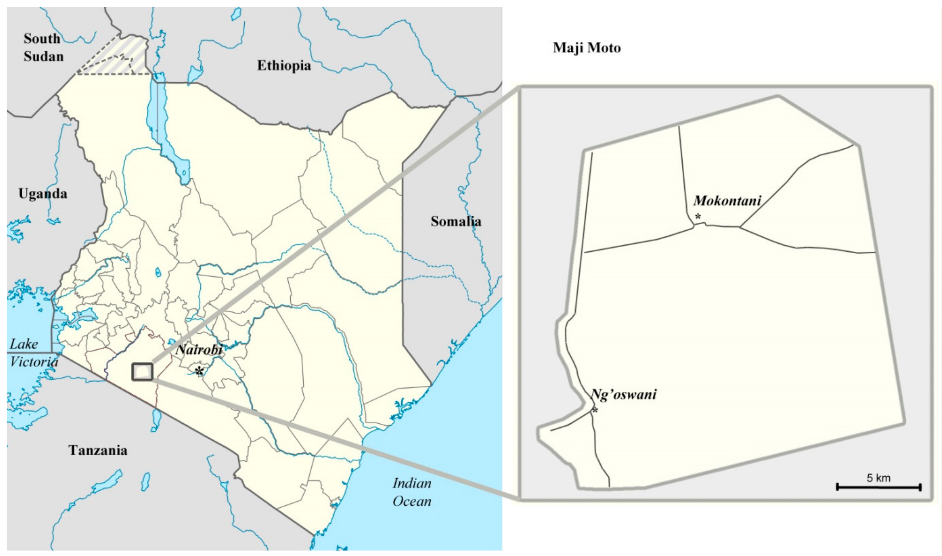
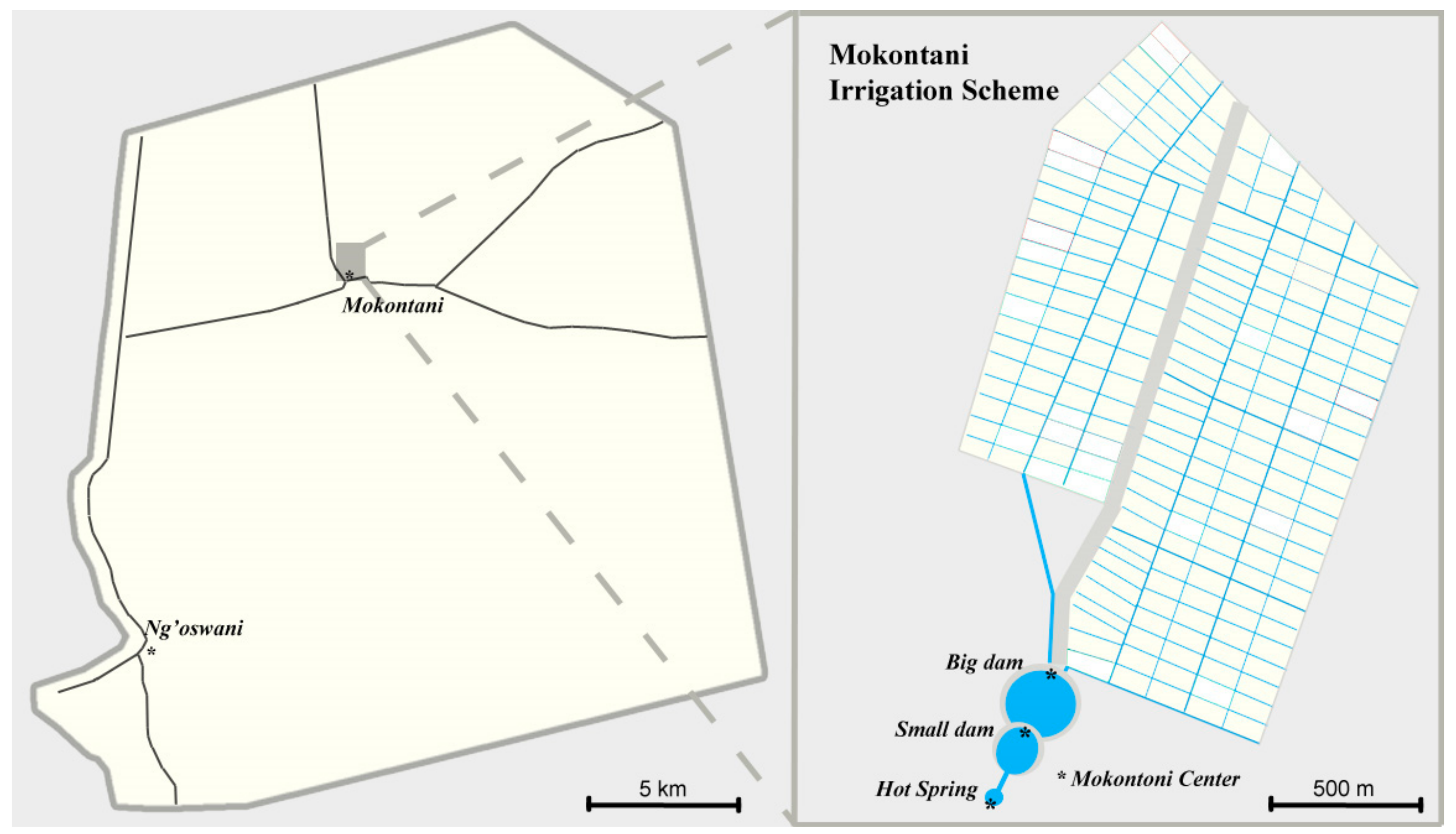
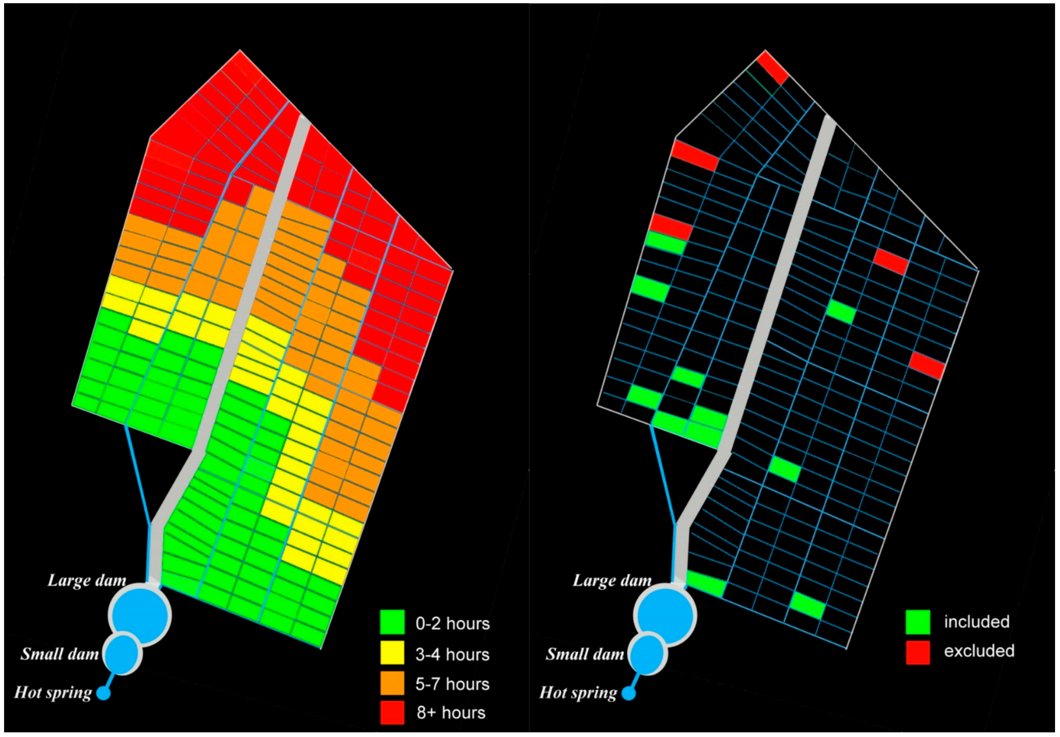
Table 1.
Agro-pastoralists’ rating of water sufficiency in the dam and accessibility for irrigation use after the Maji Moto Community Water Project (MMCWP).
Table 1.
Agro-pastoralists’ rating of water sufficiency in the dam and accessibility for irrigation use after the Maji Moto Community Water Project (MMCWP).
| Good | Average | Bad | |
|---|---|---|---|
| Water sufficiency in the dam (n = 15) | 5 | 10 | 0 |
| Water accessibility for irrigation (n = 15) | 1 | 5 | 9 |
Table 2.
Number of agro-pastoralists indicating to have experienced water-related conflicts.
| Before MMCWP | After MMCWP (of Which Violent) | |
|---|---|---|
| Experienced conflicts between agro-pastoralists (n = 16) | 0 | 14 (4) |
| Experienced conflicts between agro-pastoralists and pastoralists (n = 16) | 0 | 7 (1) |
| Experienced conflicts between agro-pastoralists and the WC (n = 16) | 0 | 7 (3) |
Table 3.
Number of pastoralists indicating the changes in level of water availability.
| Before the MMCWP (n = 51) | After the MMCWP (n = 51) | |||||
|---|---|---|---|---|---|---|
| Good | Average | Bad | Good | Average | Bad | |
| Water sufficiency | 1 | 24 | 26 | 20 | 23 | 8 |
| Water accessibility | 12 | 29 | 10 | 6 | 4 | 41 |
Table 4.
Number of pastoralists indicating their feeling of closeness with fellow pastoralists after the MMCWP and initiation of land demarcation (n = 51).
Table 4.
Number of pastoralists indicating their feeling of closeness with fellow pastoralists after the MMCWP and initiation of land demarcation (n = 51).
| Feels Closer | Feels No Change | Feels Less Close |
|---|---|---|
| 2 | 25 | 24 |
© 2018 by the authors. Licensee MDPI, Basel, Switzerland. This article is an open access article distributed under the terms and conditions of the Creative Commons Attribution (CC BY) license (http://creativecommons.org/licenses/by/4.0/).
Share and Cite
MDPI and ACS Style
Weesie, R.; Kronenburg García, A. From Herding to Farming under Adaptation Interventions in Southern Kenya: A Critical Perspective. Sustainability 2018, 10, 4386. https://doi.org/10.3390/su10124386
AMA Style
Weesie R, Kronenburg García A. From Herding to Farming under Adaptation Interventions in Southern Kenya: A Critical Perspective. Sustainability. 2018; 10(12):4386. https://doi.org/10.3390/su10124386
Chicago/Turabian StyleWeesie, Ruben, and Angela Kronenburg García. 2018. "From Herding to Farming under Adaptation Interventions in Southern Kenya: A Critical Perspective" Sustainability 10, no. 12: 4386. https://doi.org/10.3390/su10124386
Note that from the first issue of 2016, this journal uses article numbers instead of page numbers. See further details here.