
Effects of Topographic Factors on Cultivated-Land Ridge Orientation in the Black Soil Region of Songnen Plain

School of Public Administration and Law, Northeast Agricultural University, Harbin 150030, China
*
Author to whom correspondence should be addressed.
Land 2022, 11(9), 1489; https://doi.org/10.3390/land11091489
Submission received: 9 August 2022
/
Revised: 27 August 2022
/
Accepted: 1 September 2022
/
Published: 5 September 2022
(This article belongs to the Special Issue New Insights in Mollisol Quality and Management)
Abstract
:Topographic factors are essential to the spatial distribution of ridge orientation, yet the literature shows limited exploration of the mechanisms underlying the effects of terrain on cultivated-land ridge orientation in a black soil region. To better understand this subject, interpretation, statistical analyses and field verification were carried out in Songnen Plain, a typical Mollisol area. The results revealed that inclined-ridge cultivation was the most common farming method in the study area. When the slope gradient of cultivated land was greater than 13°, the influence of slope on ridge orientation was obvious, and the residual ridge angle increased with the increase in slope. There was a strongly significant negative correlation between the residual ridge angle and the azimuth angle, and the proportion curves of all ridge orientations with respect to different slope aspects were axisymmetric with respect to azimuth angles of 0°–180°. The relationship among indices such as slope gradient, slope aspect and ridge orientation could be modeled using a Poly2D function. This study indicates that topographic factors are the dominant factor in ridge-orientation selection, and provides a scientific basis for block-scale cultivated-land protection and utilization in black soil region; however, the scientific configuration of ridge orientation requires further research.
1. Introduction
Ridge farming is an agricultural farming method that is widely practiced all over the world. It refers to a farming model whereby a ridge is formed on the upper part of the planting row by plowing, and crops are sown in the ridge during the crop growth period. Ridges are among the main factors affecting the hydrology of farmland systems, as they improve topsoil physical and hydrological properties [1,2]. Relevant studies confirm that at middle and high latitudes, cultivated-land ridge orientation affects the light radiation intensity, soil temperatures and water distribution patterns to a certain extent. Furthermore, it affects the intensity of crop photosynthesis; the runoff and sediment production of cultivated land; and the transport processes of nitrogen, phosphorus, potassium and other nutrients in soil [3,4,5]. Reasonable ridge allocation plays a significant role in the efficient and sustainable utilization of cultivated land. Shufang Guo’s research shows that horizontal-ridge cultivation effectively reduces soil erosion and nutrient loss in sloping farmland in hilly areas [6]. Nonetheless, few attempts have been made to investigate the scientific basis of ridge orientation.
As one of the major factors of soil formation, the influence of terrain on soil properties and crop yield has attracted increasing attention in recent years. Numerous studies confirm that terrain is one of the key factors affecting soil temperature and water status [7,8]. Marcel Prévost found a trend of decreased %PPFD (photosynthetic photon flux density) with decreasing slope, and the mean daily %PPFD decreased from the north to the south [9]. Tao Chen’s study indicated that the total runoff decreased exponentially with slope gradient increasing [10]. On a smaller scale, soil temperature, soil moisture and vegetation communities are all affected by slope gradient and aspect; this results in microclimates that can be fundamentally different from the local and regional climatic conditions [11]. Prior work highlights and demonstrates that slope aspect determines the solar radiation input, which in turn affects soil temperature, soil water retention, nutrient dynamics, plant photosynthesis and plant transpiration, resulting in spatial differences among crop yields [12]. Land cover and slope gradient affect surface runoff generated from the plots, and further affect the soil and water conservation capacity of the land [13,14]. In fact, as slope increases, the amount of runoff gradually increases, and soil erosion also intensifies [13].
Although extensive research has been conducted on the effects of topographic factors and ridge orientation on the one hand, and on soil erosion and crop yield on the other [15,16], topographic factors and ridge orientation do not exist independently [17]. Therefore, as a farming condition, ridge orientation results from farmers resisting terrain disadvantages and represents a strategy for farmers to ensure yield under specific terrain conditions [18,19]. The complex relationship between ridge orientation and topographic factors needs in-depth study; however, there has been insufficient research on the relationship between topographic characteristics and ridge orientation.
The Mollisol area of Songnen Plain is China’s most important grain-producing area [20], but the terrain is undulating, and the spatial distribution of ridge orientation is disordered. The optimal layout of ridge orientation is an important part of the practical use of cultivated land in this area. However, in recent years, due to its flood-prone geomorphology, long-term high-intensity utilization and unreasonable agricultural farming measures, soil fertility in the Mollisol area of Songnen Plain has decreased significantly; grain yield has also declined, and soil and water loss in some areas have increased considerably [21]. Hence, given that the influence of ridge orientation on soil nutrients and crop yield, combined with the regional characteristics of land cultivation, defining the influence of parcel-scale slope gradient and slope aspect on ridge orientation is of clear significance for the formulation of scientific and practical farming models and for ensuring cultivated land and food security in this Mollisol area.
Therefore, to explore the influence of topographic factors on the ridge orientation of cultivated land, this study selected a typical Mollisol area in Songnen Plain as the research object. The overarching purpose was to unravel the relationship among cultivated-land slope gradient, slope aspect and ridge orientation on a parcel scale. To this end, we formulated two hypotheses: (1) There was a positive correlation between the cultivated-land slope gradient and the residual ridge angle; the larger slopes had a more obvious trend of horizontal-ridge tillage. (2) The azimuth angle of cultivated land had a significant influence on the distribution of ridge orientation, and the sunny-slope cultivated land was mainly characterized by longitudinal-ridge tillage.
2. Materials and Methods
2.1. Study Area
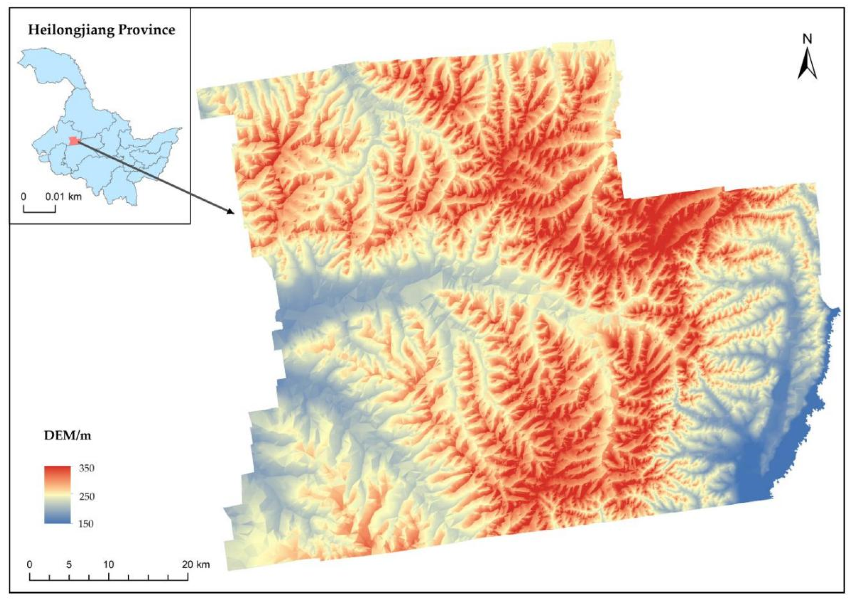
This study was conducted in the middle part of the northern Songnen Plain (latitude, 47°17′–47°54′ N; longitude 125°29′–126°31′ E), a typical black soil region in northeast China. The total land area of the study area is 3599.15 km2, including 2759.63 km2 of cultivated land, which mainly grows corn, soybean, wheat and other food crops. In contrast, the cash crops mainly include edible fungi, Lentinus edodes, black fungus and cantaloupe. It is situated at the Xiaoxingan Mountains–Songnen Plain intersection, where the terrain is high in the northeast and low in the southeast (Figure 1). The altitude ranges from 161 to 325 meters. The geomorphological types include hilly platform, undulating platform, gently inclined flat platform and floodplain, among which shallow mountains and low hills account for a large proportion. The region has a typical moderately temperate continental monsoon climate, with rain and warm temperatures. The annual average precipitation is 490 mm, and annual average temperature is 1.2 °C. The average annual sunshine amounts to 2730 h, and the frost-free period is 122 days. The soil is mainly Mollisol, supplemented by Chernozem and Meadow soil, with a soil-layer thickness of more than one meter. In addition, the soil is neutral or slightly acidic, with rich humus (Table 1).
2.2. Data Sources
The primary datasets, including aerial imagery data from UAVs (spatial resolution = 1 m), digital elevation model (DEM) data (Shuttle Radar Topography Mission (SRTM)) and vector spatial data of cultivated-land parcels were used in this study.
Aerial imagery from UAVs was provided by the government of Baiquan County, Qiqihar City. SRTM is a radar product with 30 m spatial resolution. SRTM is used by many terrain analysis researchers due to its high-precision DEM of the Earth’s surface [22]. The DEM data collected by the space shuttle mission have had a significant impact on the field of terrain analysis [23]. The vector spatial data of cultivated-land parcels were obtained from the 2018 Ministry of Agriculture database, containing information used to confirm the contracted management of the right to rural land.
2.3. Extraction of Topographic Factors
The extraction of all topographic factors was performed using ArcGIS. Firstly, the Hydrological Analysis tools in the Spatial Analyst extension were used to fill depressions within the DEM to ensure the accuracy of topographic variables that were extracted. Then, the plane slope and plane slope aspect algorithm were used to extract the slope gradient and the azimuth angle of cultivated land, which were run by Surface Analysis Tool [24]. Finally, spatial analyst method was used to calculate the average slope gradient θ and azimuth angle β of each cultivated-land parcel, the raster-data result was assigned to the cultivated-land vector layer, the above methods were achieved by the Extraction and Zonal Tools [25].
Cultivated land with areas too small to extract slope and azimuth angle was excluded from the analyses, and the final remaining cultivated-land parcels were 483,214, of which 10,834 parcels were flat land. Slope aspect was classified into four categories: shady slope (northern slope, 0–45° and 315–360°); semi-shady slope (western slope, 45–135°); sunny slope (southern slope, 135–225°); and semi-sunny slope (western slope, 225–315°) [26]. The slope gradient was divided into four categories: 0–2°, 2–6°, 6–15° and 15–25° [27].
2.4. Extraction of Ridge Orientation
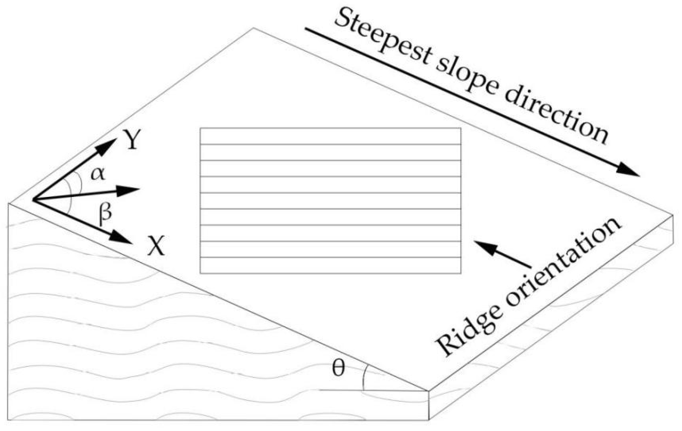
The Minimum Bounding Geometry tool can get the minimum bounding geometry of a closed single input element and [24]. First, the Minimum Bounding Geometry tool was used to process each parcel unit’s cultivated-land vector layer, and the long-side azimuth α of the outer rectangle was obtained for each cultivated-land parcel, which was the absolute ridge orientation of the farmland parcel. The cultivated land in this study is sloping cropland, however, and the ridge orientation determined was relative to slope aspect. For example, the horizontal ridge referred to the planting mode in which the direction of the crop ridge was vertical to the slope aspect of the parcel, while the longitudinal ridge was the planting method in which the direction of the crop ridge was parallel to the slope aspect of the cultivated-land parcel. Therefore, it was necessary to subtract the azimuth angle β from the long-side direction angle α; the result of β–α was the angle between the slope aspect and ridge orientation, termed the residual ridge angle (Figure 2). When the residual ridge angle was in the range 0°–10°, the ridge orientation is longitudinal; when the residual ridge angle was in the range 80°–90°, the ridge orientation is horizontal; the other orientations were referred to as inclined ridges [28].
Finally, the extraction results of the ridge orientation of cultivated land were combined with the 30 m DEM data and the high-resolution aerial imagery from UAVs for interpretation and verification. The field verification of the ridge orientation of cultivated land in the study area was conducted in April 2022 to ensure data extraction accuracy. The ridge-orientation recognition accuracy was more than 95%, which matched the research needs.
2.5. Statistical Analysis
The distributions of slope gradient, slope aspect and ridge orientation were obtained using the regional geometric statistics and DEM. To further understand the relationship among these three variables, we calculated Pearson correlation coefficients among slope gradient, azimuth angle and residual ridge angle using SPSS 26. The Pearson correlation coefficient, proposed by Carl Pearson, is defined as the correlation coefficient between rank variables [29]. If a correlation was statistically significant (p < 0.05), then we used the Cosine, Lorentz2D and Poly2D models to fit the correlation among the three variables, and the regression coefficients, residual error, R2, adjusted R2 and statistical significance of the model were calculated using MATLAB software to compare the fitting effects of each model [30].
3. Results
3.1. Characteristics of Slope Gradient, Slope Aspect and Ridge Orientation
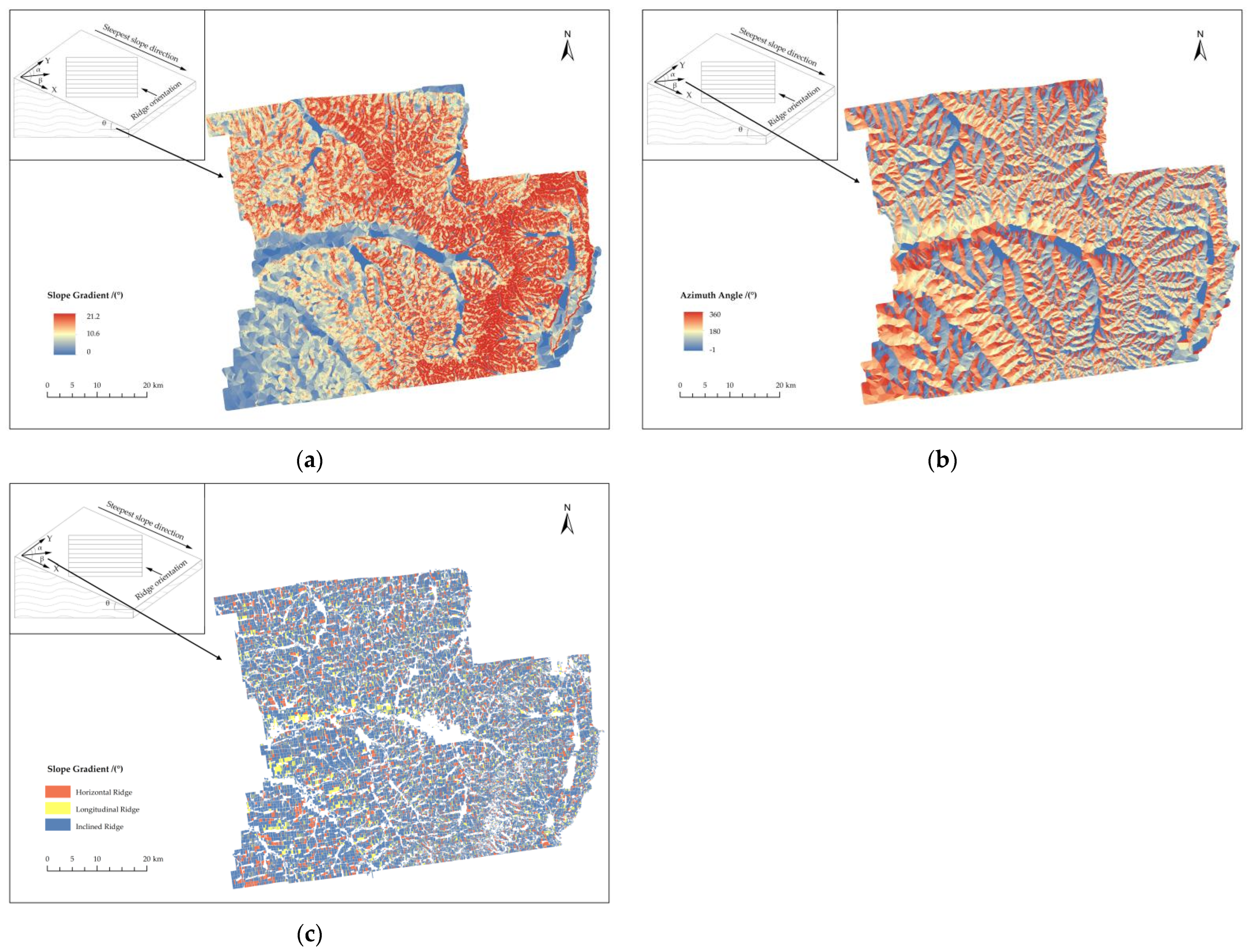
A total of 483,214 cultivated-land parcels were measured in this study, and the slope gradient, slope aspect and ridge orientation of agricultural land were found to have complex variations in this study area (Figure 3). The slope gradients of these cultivated-land parcels ranged from 0.00° to 21.20° in a positively skewed distribution. Most of the cultivated-land parcel gradients were below 5° (95.6% of the land). Among these, 134,791 parcels, representing the greatest number in this study, were in the 0°–2° gradient category. In terms of land area, 1316.05 km2 of cultivated land (53.88%) was distributed in the 0°–2° gradient, 1067.44 km2 (43.70%) was in the 2°–6° gradient, 58.88 km2 (2.41%) was in the 6°–15° gradient, and 0.10 km2 (0.01%) was in the 15°–25° gradient.
The cultivated-land azimuth angles ranged from 0° to 360°. The distribution curve of the cultivated-land parcel azimuth angles formed a “concave” type. The azimuth angles were mainly concentrated in the 50°–290° category, and the number of cultivated-land parcels in this range of azimuth angles accounted for 75.3% of the total number of samples. The cultivated-land slope aspects were divided into shady, semi-shady, sunny and semi-sunny slopes. The cultivated area on semi-shady slopes was 761.72 km2, accounting for the largest proportion (31.19%) of the total cultivated-land area; this was followed by the cultivated-land areas on semi-sunny slopes and sunny slopes, which accounted for 27.94% and 26.41%, respectively; the cultivated-land area on shady slopes was the least, 353.36 km2, accounting for only 14.46%.
The number of cultivated-land parcels gradually increased with the residual ridge angle, with the largest number of cultivated-land parcels corresponding to an angle of 85°. In addition, it was worth noting that two values of the residual ridge angle, 0° and 85°, were special. In fact, a rapid increase in parcels was found with respect to the 0° residual ridge angle, whereas declines were observed with respect to the 85° residual ridge angle. In this study, cultivated land was mainly inclined-ridge farming, with an area of 1852.62 km2, accounting for 75.85% of the total cultivated land; this was followed by the cultivated-land area of horizontal-ridge cultivation (365.89 km2) and its proportion (14.98%), and by the arable land area (223.96 km2) and the proportion of longitudinal-ridge farming (9.17%).
The overall slope in the southwest part of the study area was relatively gentle, and the highly sloping area was mainly concentrated in the eastern region. The same result was also reflected in the slope aspect map (Figure 3). Ridge orientation was more continuous in the southwest, and it was most fragmented in the northeast. This was consistent with the geomorphological pattern of drainage in the western part of the study area and the transitional zone of the Xiaoxingan Mountains in the northeast. The ridge-orientation distribution of cultivated land was disorderly, fully reflecting the topographic low-hill characteristics of study area. Longitudinal ridges were mainly distributed in the southwest, mainly due to the gentle slope in this area.
3.2. Slope-Gradient Effects on Ridge Orientation
Overall, there was a strongly significant positive correlation between slope gradient and residual ridge angle (p < 0.01). There were differences in the correlation between slope and ridge angle under diverse slope aspect conditions (Table 2). It could be seen that slope aspect affected the correlation between slope gradient and ridge orientation. The gradient of shady and sunny slopes were positively correlated with the residual ridge angle. In contrast, the gradient of semi-shady and semi-sunny slopes were negatively correlated with the residual ridge angle.
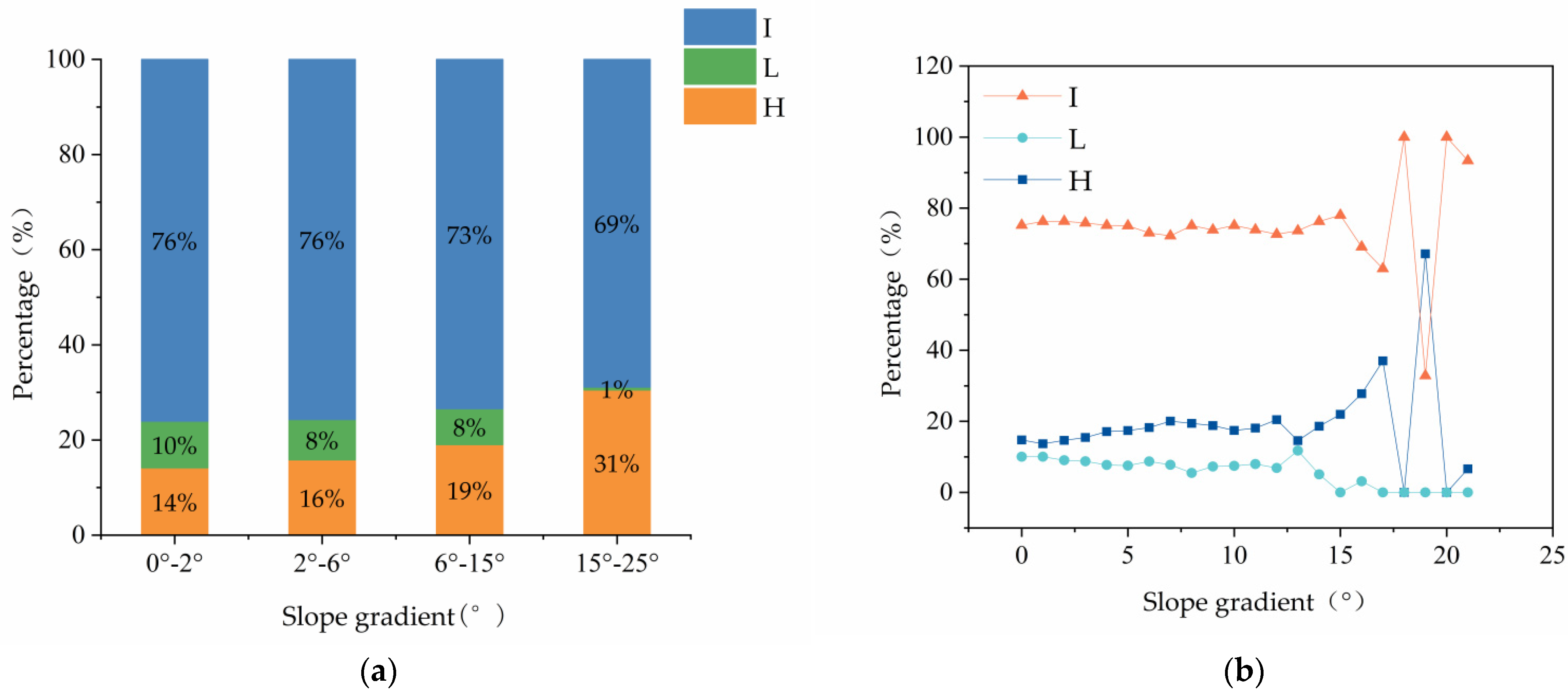
The proportion of ridge orientation at each slope level was inclined ridge > horizontal ridge > longitudinal ridge, and inclined ridges dominated at different slope levels (Figure 4a). The proportion of inclined ridges and longitudinal ridges gradually decreased with the increase in the slope grade, while the opposite was true for the horizontal ridge. Compared with the 0°–2° sloping land, the proportion of inclined ridges in cultivated land with slopes of 6°–10°, 10°–15° and 15°–22° decreased by 0%, 3% and 7%, respectively, and the proportion of longitudinal ridges decreased by 2%, 2% and 9%, respectively, whereas the proportion of horizontal ridges increased by 2%, 5% and 17%, respectively. The variation in ridge orientation with slope showed obvious heterogeneity, and the horizontal ridge was the most sensitive to slope.
The proportion curves of the various ridge orientations were relatively stable when the slope was gentle, and the changing trend was obvious with the increase in slope (Figure 4b). When the slope gradient was less than 13°, the proportion of cultivated land for each ridge orientation was stable. When the slope gradient was greater than 13°, the trend in the proportion of each ridge orientation changed noticeably. The influence of slope on ridge orientation mainly occurred with slopes greater than 13°. When the slope gradient was 13°–15°, the proportion of inclined ridges slowly increased with the increase in slope, while the proportion of longitudinal ridges rapidly decreased, and the proportion of horizontal ridges showed a steep upward trend. As a result, the effects on horizontal ridges and longitudinal ridges were more obvious when the slope gradient was in the range 13°–15°. When the slope gradient was 15°–17°, the area of inclined-ridge farmland rapidly decreased with the increase in slope; the longitudinal ridge first slightly increased and then decreased and remained the same. Therefore, when the slope gradient ranged from 15° to 17°, the effect of slope on inclined ridges and horizontal ridges was more significant. Since the area of cultivated land with a slope greater than 17° was minor, the regularity was not obvious in the figure, and therefore not discussed here.
3.3. Slope Aspect and Ridge Orientation
There was a very significant negative correlation between cultivated-land azimuth angle and residual ridge angle (p < 0.01), and the correlation between cultivated-land azimuth angle and residual ridge angle varied for different slope-gradient grades (Table 3). There was a negative correlation between the azimuth angle and the residual ridge angle for cultivated land with a slope gradient of 0°–15°. There were no significant correlations between the azimuth angle and the residual ridge angle for cultivated land with a slope gradient of 15°–22° owing to the small sample size of cultivated land in that angle range.
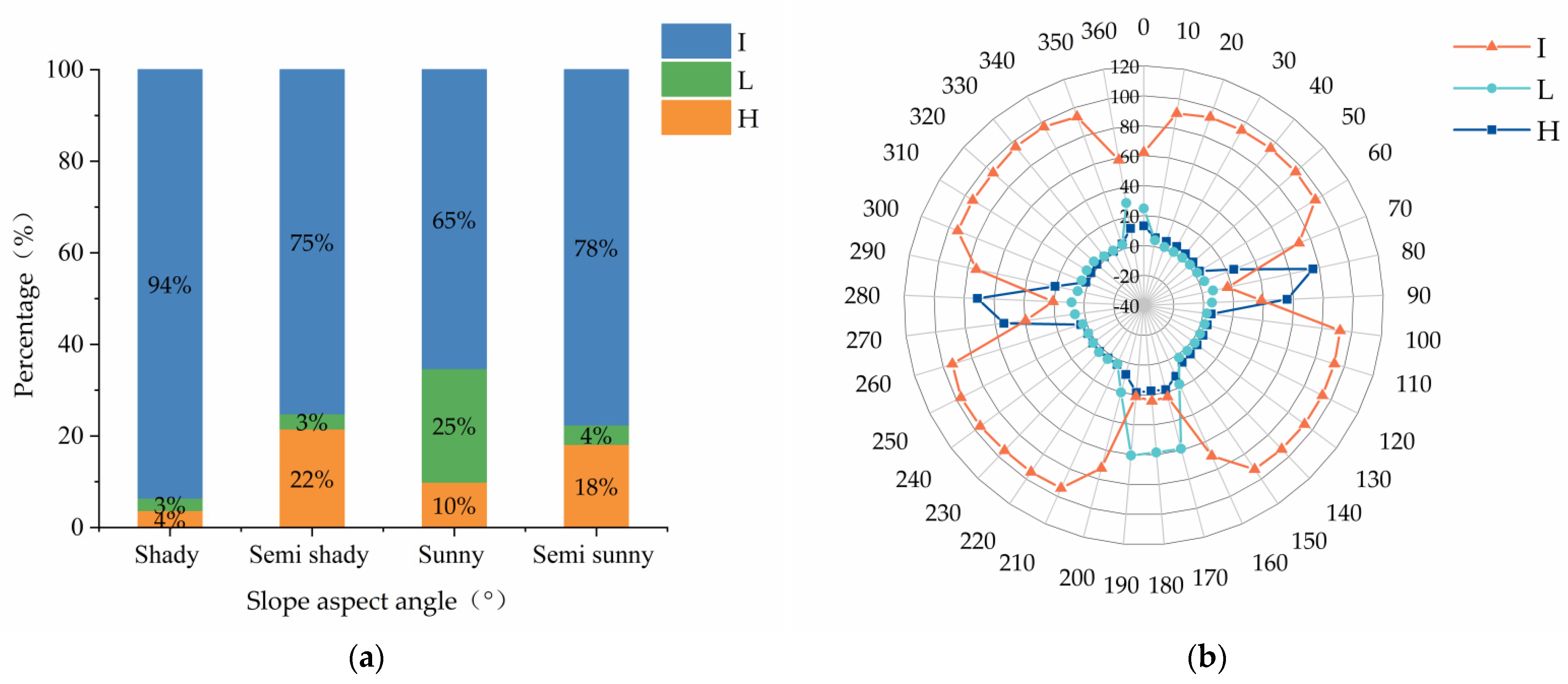
There were certain differences in the proportion of all kinds of ridge orientations with respect to various slope aspect grades. The proportion of each ridge orientation of cultivated land on sunny slopes was inclined ridge > longitudinal ridge > horizontal ridge, and the order of proportion of all ridge orientations on other cultivated land was inclined ridge > horizontal ridge > longitudinal ridge (Figure 5a). The change range of the area proportion for each cultivated-land ridge orientation was different with respect to various slope-aspect grades. The maximum range of inclined-ridge farmland area with respect to different slope aspects was 29%, with this being the highest for shady slopes, the lowest for sunny slopes and the same for semi-shady and semi-sunny slopes. The maximum changed range of the proportion of longitudinal-ridge farmland area was 22% and highest for sunny slopes, and the proportion with respect to other slope aspects was relatively stable. The maximum change range of horizontal-ridge farmland area was 18% and highest for semi-shady slopes and the lowest for shady slopes.
For different azimuth angles, the area-proportion curve for all ridge orientations was distinct (Figure 5b). Among them, the broken line of the proportion of inclined ridges was centrally symmetrical, and the changes mainly occurred in the four cardinal directions (north, south, east and west), indicating that ridge orientation had the most certain influence on the distribution of inclined ridges in these four directions. The percentage break line of longitudinal ridges was symmetrical, with slope aspects of 0°–180° being the reference line, and the changes were mainly found where cultivated-land ridges were oriented toward the northern and southern directions, indicating that slope aspect had a certain effect on longitudinal ridges in the two directions. The broken line of horizontal-ridge proportion was symmetrical, with 0°–180° slopes forming the baseline, and the changes mainly occurred with easterly and westerly cultivated-land slope aspects, indicating that ridge orientation had a certain effect on horizontal-ridge orientation in the two directions. Unlike the relationship between slope gradient and ridge orientation, the proportion of inclined-ridge cultivated land did not always occupy a dominant position among the various slope aspects. The phenomenon of horizontal ridge > inclined ridge > longitudinal ridge appeared when the azimuth angles were 80°–90° or 270°–280°, and the phenomenon of longitudinal ridge > inclined ridge > horizontal ridge appeared when the azimuth angles were 170°–190°.
3.4. Ridge Orientation under the Combined Action of Slope Gradient and Slope Aspect
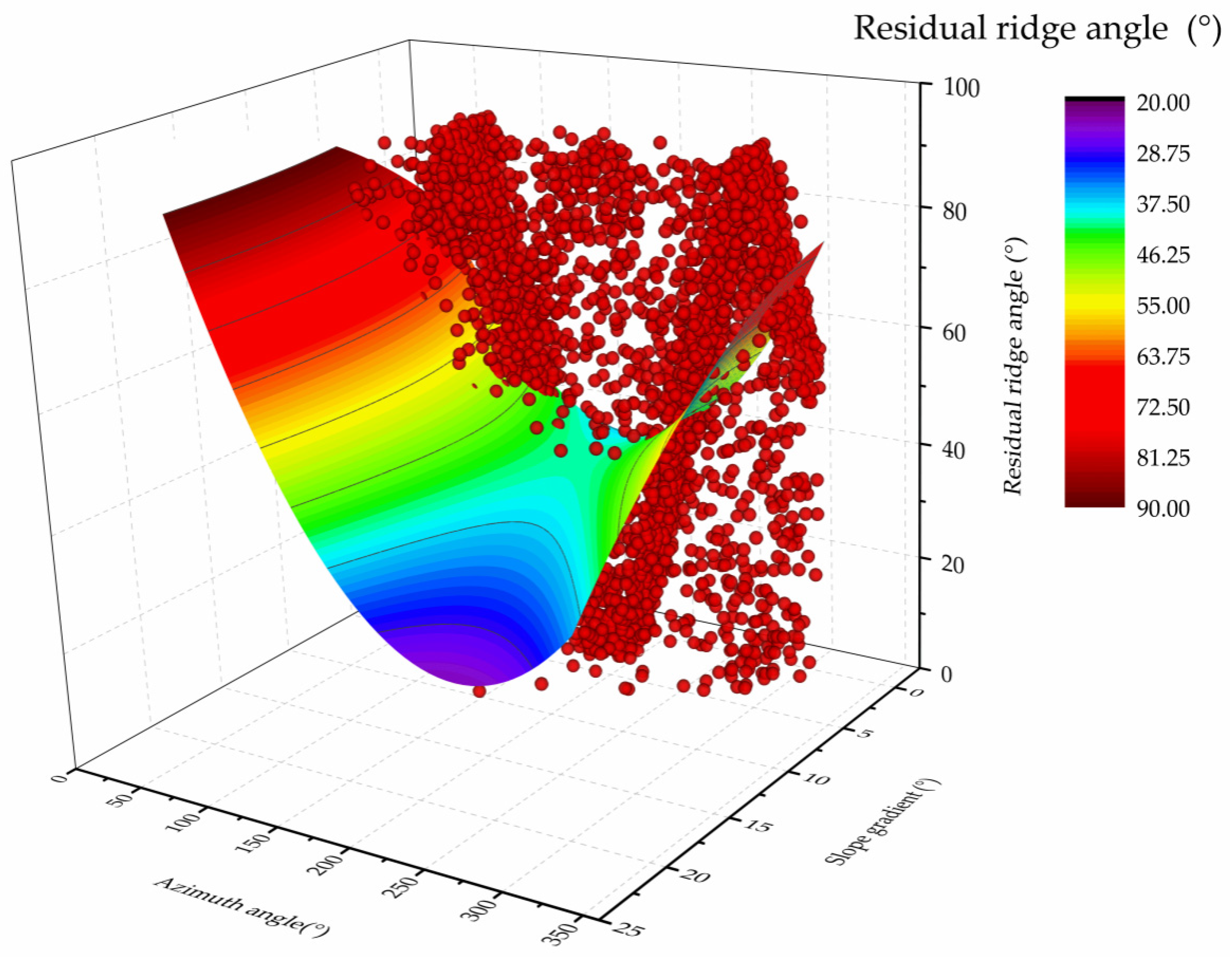
The Cosine, Lorentz2D and Poly2D models were used to fit the slope gradient, azimuth angle and residual ridge angle, respectively. Among them, the Lorentz2D model did not converge during fitting, causing the fitting to fail. As can be seen, when we fitted the remaining two models, the Poly2D model’s equation had a larger R-squared value (R2 = 0.17484) and could be employed to predict the data (Table 4).
The influence of slope gradient and azimuth angle on the residual ridge angle was an approximately symmetrical inverse paraboloid (Figure 6). The residual ridge angle varied noticeably with slope aspect relative to the same slope gradient. The main variation was that the residual ridge angle first decreased and then increased, with the azimuth angle enlarging, while relative to the same slope aspect, the residual ridge angle gradually increased as the slope gradient increases, but the regularity was not obvious.
Fitted curve: Poly2D
Y = 101.787 + 3.159 × X1 − 0.727 × X2 − 0.065 × X12 + 0.002 × Y2 + 0.012 × X1 × X2
Fitted curve: Cosine
where X1 is the slope gradient, X2 is the azimuth angle and Y is the residual ridge angle.
Y = 51.554 + 0.985 × cosX1 − 0.078 × cosX2 + 0.029 × cos(2 × X1) + 0.202 × cosX1 × cosX2 + 0.005 × cos(2 × X2)
4. Discussion
4.1. Spatial Distribution of Ridge Orientation
In this study, we found that cultivated land in the Mollisol area of Songnen Plain was mainly represented by inclined ridges. As a result of northeast China’s lengthy winter and the early melting of snow and ice in spring, horizontal-ridge farming was not favorable to drainage. Since the beginning of land reclamation in northeast China’s Mollisol area, cultivated land had generally been in the form of inclined ridges or longitudinal ridges to discharge the melting snow as soon as possible, increase the soil temperature and mature the soil [31]. As a typical Mollisol area, the soil and water loss in Songnen Plain are very serious, and erosion ditches densely cover the area [32]. Several studies had suggested that when planting along a slope, there were no barriers on the ridge platform to intercept the surface runoff formed after the soil water saturation of the ridge and furrow. The runoff velocity and erosive force in the ridge and furrow rapidly increased; this was coupled with the single-peak rainfall in summer in this area, resulting in the further increased in the intensity of slope erosion, which was not conducive to soil and water conservation [33,34]. In addition, the previous study had stated that inclined-ridge cultivation could change the direction of surface runoff and reduce the flow velocity, reducing the actual slope of cultivated land and alleviating the terrain disadvantage of sloping farmland [35].
4.2. Slope-Gradient Effects on Ridge Orientation
Our study indicated that slope gradient and residual ridge angle had a strongly significant positive correlation, and the proportion of horizontal ridges increased with the increase in slope, which was consistent with the first hypothesis. Our results revealed that farmers had a certain awareness of cultivated-land protection, because when determining the ridge orientation of cultivated land, slope was considered to be the key factor affecting cultivated-land erosion. It was also the core means to control slope-runoff flow velocity and flow shear force. Moreover, with the increase in slope, the soil erosion of cultivated land intensified, so horizontal-ridge cultivation was adopted in cultivated land with greater slopes [36,37]. Our result was consistent with the traditional view that horizontal-ridge cultivation was the most widely used conservation tillage measure to manage soil erosion [6]. Although horizontal-ridge tillage was widely used to prevent and control soil erosion on sloping farmland in northern China, horizontal-ridge failure was a common phenomenon [38]. Related studies had shown that horizontal-ridge soil and water conservation capacity might be weakened on steep slopes or under high-intensity rainfall, and that farmers should follow the ground profile as much as possible to achieve the effect of soil erosion control [39,40]. However, the study area is characterized by a flood-prone topography, and its terrain is undulating. In the actual ridging operation, the horizontal ridge could not be completely parallel to the outline of cultivated land [41]. Furthermore, the soil stability of the ridge and mound under mechanical tillage in the Mollisol area of northeast China was relatively poor. In the case of a short-duration rainstorm, sufficient runoff could be generated along the ditch and gathered in low-lying areas. This could generate super-seepage runoff, which could gather along the horizontal ridges of sloping farmland. Moreover, super-seepage runoff could break the ridges in fragile bridges and low-lying places. Meanwhile, a concentrated stream could form and produce a huge runoff shear force. If the shear force exceeded the erosion resistance of the soil, gully erosion could occur [42]. Therefore, in the Songnen plain area with serious soil erosion, the single horizontal-ridge measure could not effectively prevent farmland erosion. Ridge orientation should be arranged according to local slope conditions, then, the runoff could be effectively regulated and soil erosion could be prevented Compared with horizontal slope-ridge cultivation, inclined-ridge cultivation was more suitable for conserving soil and water in areas of low hills such as the study area.
4.3. Effects of Slope Aspect on Ridge Orientation
The study showed that slope aspect significantly affected the distribution of the ridge orientation of cultivated land, with inclined ridges accounting for the highest proportion in shady-slope cultivated land. Longitudinal ridges were mainly distributed on the sunny slopes of cultivated land. Horizontal ridges were mainly distributed in semi-shady- and sunny-slope cultivated land, supporting the second hypothesis. Previous studies had supported this result. For instance, studies by Sternberg, Bauer and others had found that slope-aspect features affected water content and temperature of cultivated soils by influencing light intensity and wind direction, thus affecting plant photosynthesis and transpiration, which led to local soil microclimate groups that affected crop growth and yield [43,44]. Additionally, the fundamental driving factor of slope aspect that affects soil climate was the difference in the incident shortwave solar radiation on the slope [45]. Given that slope aspect affected solar radiation and consequently crop yield, different ridge orientations could also cause microclimate changes such as light conditions in a crop population space [18]. Along the same lines, Sharratt had found that the solar radiation absorbed by cultivated land on sunny slopes was the highest when cultivation was conducted along the ridge. In contrast, the amount of solar radiation absorbed by downward semi-shady and semi-sunny sloping land with respect to the same ridge was similar [46]. Therefore, the main reason for the difference in the distribution of each ridge orientation with respect to different slope aspects was that without increasing the cultivated-land area, the most efficient way for farmers to increase crop yield was to maximize the use of natural resources, that was, to optimize the light conditions of cultivated land with respect to different slope aspects and improve the light-energy utilization rate. In addition, the influence of slope aspect on ridge orientation was mainly concentrated in gently sloping areas, which was due to the obvious secondary distribution of water and heat in these areas. The stress pressure of soil erosion was large in steeply sloping areas, and the distribution of water and heat in the slope was weakened [47]. Therefore, the slope aspect could affect crop yield by changing light energy utilization rate, indirectly affecting ridge orientation distribution, and reasonable management of ridge orientation according to slope-aspect difference is necessary to increase crop yield in black soil region.
In addition, this study still has a lot of room for improvement in data mining analysis and modeling. It should also be noted that ridge-orientation configuration is not only affected by slope gradient and slope aspect, but also needs to consider its relationship with crop types, agricultural production efficiency, and the feasibility of actual agricultural machinery operation under some terrain. Therefore, in the future, it is necessary to strengthen the research on the influence of other factors on the distribution of cultivated land ridge orientation, and further clarify the influence of ridge orientation on crop yield and soil erosion of cultivated land, and finally put forward the optimal path for the allocation of cultivated land ridge direction in black soil region.
5. Conclusions
In conclusion, this study demonstrated that topographic factors affected the ridge orientation of cultivated land in Songnen Plain. The slope gradient of cultivated land in Songnen Plain was mainly concentrated in the range 0°–5°, with shady-slope arable land accounting for the smallest portion, and cultivated land was mostly inclined-ridge farming. There was a positive correlation between the slope gradient of cultivated land and the residual ridge angle. The influence of slope on the residual ridge angle was mainly observed when the slope gradient was greater than 13°, and the larger the slope gradient, the more obvious the trend of the horizontal ridge. There was a strongly significant correlation between the residual ridge angle and the azimuth angle. The proportion of cultivated-land area for each ridge orientation with respect to different azimuth angles was symmetrically distributed, with 0°–180° axes as the azimuth angles. Compared with the Cosine and Lorentz2D models, the Poly2D model had the best fitting effect on the slope gradient, the azimuth angle and the residual ridge angle, and the fitted surface overall presented an inverted paraboloid shape. The findings of this study have implications for the relationship between topographic factors and ridge orientation and can assist in developing sustainable cultivation of the black soil region in northeast China.
Author Contributions
Conceptualization, G.D. and T.G.; methodology, G.D.; validation, G.D., T.G. and C.M.; formal analysis, C.M.; resources, T.G. and G.D.; data curation, T.G.; writing—original draft preparation, T.G.; writing—review and editing, G.D. and C.M.; visualization, T.G. and C.M.; supervision, G.D.; project administration, G.D.; acquisition of funding, G.D. All authors have read and agreed to the published version of the manuscript.
Funding
This research was funded by the National Key R&D Program of China, grand No. 2021YFD1500101 and the Youth Talent Project of the Northeast Agricultural University of China, grand No. 19QC35.
Institutional Review Board Statement
Not applicable.
Informed Consent Statement
Informed consent was obtained from all subjects involved in the study.
Data Availability Statement
Not applicable.
Acknowledgments
We would like to express our gratitude to the professionals of the Northeast Agricultural University who encouraged us to make this project a success.
Conflicts of Interest
The authors declare no conflict of interest.
References
- Burwell, R.E.; Allmaras, R.R.; Sloneker, L.L. Structural alteration of soil surfaces by tillage and rainfall. J. Soil Water Conserv. 1966, 21, 61–63. [Google Scholar]
- Shi, X.H.; Yang, X.M.; Drury, C.F.; Reynolds, W.D. Impact of ridge tillage on soil organic carbon and selected physical properties of a clay loam in southwestern Ontario. Soil Tillage Res. 2012, 120, 1–7. [Google Scholar] [CrossRef]
- Ren, B.; Dong, S.; Liu, P.; Zhao, B.; Zhang, J. Ridge tillage improves plant growth and grain yield of waterlogged summer maize. Agric. Water Manag. 2016, 177, 392–399. [Google Scholar] [CrossRef]
- Liu, M.X.; Wang, J.A.; Yan, P.; Liu, L.Y.; Ge, Y.Q.; Li, X.Y.; Hu, X.; Song, Y.; Wang, L. Wind tunnel simulation of ridge-tillage effects on soil erosion from cropland. Soil Tillage Res. 2006, 90, 242–249. [Google Scholar] [CrossRef]
- Jiang, R.; Li, X.; Zhu, W.; Wang, K.; Guo, S.; Misselbrook, T.; Hatano, R. Effects of the ridge mulched system on soil water and inorganic nitrogen distribution in the Loess Plateau of China. Agric. Water Manag. 2018, 203, 277–288. [Google Scholar] [CrossRef] [PubMed]
- Guo, S.; Zhai, L.; Liu, J.; Liu, H.; Chen, A.; Wang, H.; Wu, S.; Lei, Q. Cross-ridge tillage decreases nitrogen and phosphorus losses from sloping farmlands in southern hilly regions of China. Soil Tillage Res. 2019, 191, 48–56. [Google Scholar] [CrossRef]
- Wei, Z.; Duan, S.B.; Li, A.; Yin, G. A practical method for reducing terrain effect on land surface temperature using random forest regression. Remote Sens. Environ. 2019, 221, 635–649. [Google Scholar] [CrossRef]
- Patton, N.R.; Lohse, K.A.; Seyfried, M.S.; Godsey, S.E.; Parsons, S.B. Topographic controls of soil organic carbon on soil-mantled landscapes. Sci. Rep. 2019, 9, 6390. [Google Scholar] [CrossRef]
- Prévost, M.; Raymond, P. Effect of gap size, aspect and slope on available light and soil temperature after patch-selection cutting in yellow birch–conifer stands, Quebec, Canada. For. Ecol. Manag. 2012, 274, 210–221. [Google Scholar] [CrossRef]
- Chen, T.; Shu, J.; Han, L.; Tian, G.; Yang, G.Y.; Lv, J.X. Modeling the effects of topography and slope gradient of an artificially formed slope on runoff, sediment yield, water and soil loss of sandy soil. Catena 2022, 212, 106060. [Google Scholar] [CrossRef]
- Bennie, J.; Huntley, B.; Wiltshire, A.; Hill, M.O.; Baxter, R. Slope, aspect and climate: Spatially explicit and implicit models of topographic microclimate in chalk grassland. Ecol. Model. 2008, 216, 47–59. [Google Scholar] [CrossRef]
- Agren, G.I.; Andersson, F.O. Terrestrial Ecosystem Ecology; NRC Research Press: Ottawa, ON, Canada, 2012. [Google Scholar] [CrossRef]
- Han, D.; Deng, J.; Gu, C.; Mu, X.; Gao, P.; Gao, J. Effect of shrub-grass vegetation coverage and slope gradient on runoff and sediment yield under simulated rainfall. Int. J. Sediment Res. 2021, 36, 34–42. [Google Scholar] [CrossRef]
- Jaleta, D.; Mbilinyi, B.P.; Mahoo, H.F.; Lemenih, M. Effect of Eucalyptus expansion on surface runoff in the central highlands of Ethiopia. Ecol. Process 2017, 6, 8. [Google Scholar] [CrossRef]
- Wu, S.; Chen, L.; Wang, N.; Zhang, J.; Ferro, V. Variable scale effects on hillslope soil erosion during rainfall-runoff processes. Catena 2021, 207, 105606. [Google Scholar] [CrossRef]
- Jaki, S.; Ninkov, J.; Mili, S.; Vasin, J.; Ivanov, M.; Jaki, D.; Komlen, V. Influence of Slope Gradient and Aspect on Soil Organic Carbon Content in the Region of Ni, Serbia. Sustainability 2021, 13, 8332. [Google Scholar] [CrossRef]
- Lan, A.; Lin, Z.; Fan, X.; Yao, M. Effects of aspects on soil environment and plant growth on the Qinghai-Tibet Plateau. J. Glaciol. Geocryol. 2022, 44, 1–12. [Google Scholar] [CrossRef]
- Goyal, A.; Vashisth, A.; Sehgal, V.K.; Pradhan, S.; Jitendra, S. Effect of row direction and cultivar on micrometeorological and biophysical parameters of oil seed Brassica. J. Agrometeorol. 2018, 20, 85–91. [Google Scholar]
- Wang, J.; Shi, X.; Li, Z.; Zhang, Y.; Liu, Y.; Peng, Y. Responses of runoff and soil erosion to planting pattern, row direction, and straw mulching on sloped farmland in the corn belt of northeast China. Agric. Water Manag. 2021, 253, 106935. [Google Scholar] [CrossRef]
- Zhao, W.; Zhou, Q.; Tian, Z.; Cui, Y.; Wang, H. Apply biochar to ameliorate soda saline-alkali land, improve soil function and increase corn nutrient availability in the Songnen Plain. Sci. Total Environ. 2020, 722, 137428. [Google Scholar] [CrossRef]
- Zhou, Z.; Li, Z.; Zhang, Z.; You, L.; Xu, L.; Huang, H.; Wang, X.; Gao, Y.; Cui, X. Treatment of the saline-alkali soil with acidic corn stalk biochar and its effect on the sorghum yield in western Songnen Plain. Sci. Total Environ. 2021, 797, 149190. [Google Scholar] [CrossRef]
- Yang, L.; Meng, X.; Zhang, X. SRTM DEM and its application advances. Int. J. Remote Sens. 2011, 32, 3875–3896. [Google Scholar] [CrossRef]
- Zhou, Y.; Li, Z.; Li, J.; Ding, X. Geodetic glacier mass balance (1975–1999) in the central Pamir using the SRTM DEM and KH-9 imagery. J. Glaciol. 2019, 65, 309–320. [Google Scholar] [CrossRef]
- Burrough, P.A.; McDonell, R.A. Principles of Geographical Information Systems; Oxford University Press: New York, NY, USA, 1998. [Google Scholar]
- Ebdon, D. Statistics in Geography, 2nd ed.; Blackwell: London, UK, 1991. [Google Scholar]
- Wang, L.; Wei, S.; Horton, R. Effects of vegetation and slope aspect on water budget in the hill and gully region of the Loess Plateau of China. Catena 2011, 87, 90–100. [Google Scholar] [CrossRef]
- National Agricultural Regional Planning Commission. Technical Regulation of Land Use Survey; Surveying and Mapping Press: Beijing, China, 1984.
- Zhao, Y.M.; Jiang, H.T.; Wang, S.J. Study on relative soil and water conservation benefits of ridge tillage in different terrain conditions in the black soil area of northeast China. Agric. Sci. Technol. 2015, 16, 2354–2360. [Google Scholar] [CrossRef]
- Yu, K.; Liu, L.; Li, J.; Ding, W.; Le, T. Multi-Source Causal Feature Selection. IEEE Trans. Pattern Anal. Mach. Intell. 2020, 42, 2240–2256. [Google Scholar] [CrossRef]
- Salkauskas, P.L. Surfaces generated by moving least squares methods. Math. Compt. 1981, 37, 141–158. [Google Scholar] [CrossRef]
- Xu, X.; Zheng, F.; Wilson, G.V.; He, C.; Lu, J.; Bian, F. Comparison of runoff and soil loss in different tillage systems in the Mollisol region of Northeast China. Soil Tillage Res. 2018, 177, 1–11. [Google Scholar] [CrossRef]
- Yang, Y.; Song, G. Human disturbance changes based on spatiotemporal heterogeneity of regional ecological vulnerability: A case study of Qiqihaer city, northwestern Songnen Plain, China. J. Clean. Prod. 2020, 291, 125262. [Google Scholar] [CrossRef]
- Zhang, S.; Zhang, J.; Liu, Y.; Liu, Y. Effects of farmland vegetation row direction on overland flow hydraulic characteristics. Hydrol. Res. 2018, 49, nh2018020. [Google Scholar] [CrossRef]
- Rong, L.; Duan, X.; Zhang, G.; Gu, Z.; Feng, D. Impacts of tillage practices on ephemeral gully erosion in a dry-hot valley region in southwestern China. Soil Tillage Res. 2019, 187, 72–84. [Google Scholar] [CrossRef]
- Liu, Q.J.; An, J.; Wang, L.Z.; Wu, Y.Z.; Zhang, H.Y. Influence of ridge height, row grade, and field slope on soil erosion in contour ridging systems under seepage conditions. Soil Tillage Res. 2015, 147, 50–59. [Google Scholar] [CrossRef]
- Li, T.; Zhao, L.; Duan, H.; Yang, Y.; Wang, Y.; Wu, F. Exploring the interaction of surface roughness and slope gradient in controlling rates of soil loss from sloping farmland on the Loess Plateau of China. Hydrol. Processes 2020, 34, 339–354. [Google Scholar] [CrossRef]
- Zhang, G.H.; Liu, Y.M.; Han, Y.F.; Zhang, X.C. Sediment transport and soil detachment on steep slopes: I. Transport capacity estimation. Soil Sci. Soc. Am. J. 2009, 73, 1291–1297. [Google Scholar] [CrossRef]
- Liu, Q.J.; Shi, Z.H.; Yu, X.X.; Zhang, H.Y. Influence of microtopography, ridge geometry and rainfall intensity on soil erosion induced by contouring failure. Soil Tillage Res. 2014, 136, 1–8. [Google Scholar] [CrossRef]
- Flanagan, D.C.; Livingston, S.J. USDA-Water Erosion Prediction Project; Report no. 11; NSERL: Richardson, TX, USA, 1995. [Google Scholar]
- USDA-ARS. Science Documentation: Revised Universal Soil Loss Equation, 2nd ed.; USDA-Agricultural Research Service: Washington, WA, USA, 2013.
- Wang, L.; He, C.; Zheng, F.L.; Bian, F.; Xu, X. Soil-bin experiment on effects of contour ridge tillage for controlling hillslope soil erosion in black soil region. Trans. Chin. Soc. Agric. Eng. 2018, 34, 141–148. [Google Scholar] [CrossRef]
- Casabella-González, M.J.; Borselli, L.; García-Meza, J.V. Soil horizon erodibility assessment in an area of Mexico susceptible to gully erosion. J. South Am. Earth Sci. 2021, 111, 103497. [Google Scholar] [CrossRef]
- Sternberg, M.; Shoshany, M. Influence of slope aspect on Mediterranean woody formations: Comparison of a semiarid and an arid site in Israel. Ecol. Res. 2010, 16, 335–345. [Google Scholar] [CrossRef]
- Bauer, A.; Black, A.L. Quantification of the Effect of Soil Organic Matter Content on Soil Productivity. Soil Sci. Soc. Am. J. 1994, 58, 185–193. [Google Scholar] [CrossRef]
- Seyfried, M.; Flerchinger, G.; Bryden, S.; Link, T.; Marks, D.; McNamara, J. Slope and aspect controls on soil climate: Field documentation and implications for large-scale simulation of critical zone processes. Vadose Zone 2021, 20, e20158. [Google Scholar] [CrossRef]
- Sharratt, B.S.; Schwarzer, M.J.; Campbell, G.S.; Papendick, R.I. Radiation Balance of Ridge-Tillage with Modeling Strategies for Slope and Aspect in the Subarctic. Soil Sci. Soc. Am. J. 1992, 56, 1379–1384. [Google Scholar] [CrossRef]
- Li, Q.; He, G.; Liu, Z.; Guan, W.; Qiao, H.; Zhang, D.; Han, T.; Sun, B.; Pan, D.; Liu, X. Response of vegetation characteristics and biodiversity of alpine meadow in east Qilian Mountains to habitat. Acta Agrestia Sin. 2022, 30, 169–177. [Google Scholar] [CrossRef]
Figure 1.
Location and topography of the study area.

Figure 2.
Diagram of ridge orientation: α, ridge angle; β, azimuth angle; θ, slope gradient.

Figure 3.
Maps showing (a) slope gradient, (b) slope aspect and (c) ridge orientation. In (c), red represents horizontal ridges, yellow represents longitudinal ridges and blue represents inclined ridges.
Figure 3.
Maps showing (a) slope gradient, (b) slope aspect and (c) ridge orientation. In (c), red represents horizontal ridges, yellow represents longitudinal ridges and blue represents inclined ridges.

Figure 4.
(a) Area-proportion map of cultivated land with all ridge orientations with respect to different slope gradients. (b) Area-proportion line chart of slope gradient and different ridge orientations of cultivated land, where: I, inclined ridge; L, longitudinal ridge; and H, horizontal ridge.
Figure 4.
(a) Area-proportion map of cultivated land with all ridge orientations with respect to different slope gradients. (b) Area-proportion line chart of slope gradient and different ridge orientations of cultivated land, where: I, inclined ridge; L, longitudinal ridge; and H, horizontal ridge.

Figure 5.
(a) Area-proportion map of all cultivated-land ridge orientations with respect to different slope aspects. (b) Proportion map of cultivated-land area with different ridge orientations with respect to different slope aspects, where: I, inclined ridge; L, longitudinal ridge; and H, horizontal ridge.

Figure 6.
Relationship among slope gradient, azimuth angle and residual ridge angle according to the Poly2D model (n = 472,380).
Figure 6.
Relationship among slope gradient, azimuth angle and residual ridge angle according to the Poly2D model (n = 472,380).


Table 1.
Soil conditions of the study area.
| Organic Matter (g/kg) | Bulk Density (g/cm3) | Total Nitrogen (g/kg) | Available Nitrogen (mg/kg) | Available Phosphorus (mg/kg) | Available Potassium (mg/kg) | pH |
|---|---|---|---|---|---|---|
| 30.5 | 1.24 | 2.01 | 8 | 16 | 208 | 6.98 |
Table 2.
Correlation between slope gradient and ridge orientation with respect to different slope aspects.
Table 2.
Correlation between slope gradient and ridge orientation with respect to different slope aspects.
| Parameter | Residual Ridge Angle | |||||
|---|---|---|---|---|---|---|
| All Slopes | Shady Slopes | Semi-Shady Slopes | Sunny Slopes | Semi-Sunny Slopes | ||
| Slope gradient | Pearson correlation | 0.061 ** | 0.240 ** | –0.037 ** | 0.254 ** | –0.152 ** |
| Significance (two-sided) | 0 | 0 | 0 | 0 | 0 | |
| Number of parcels | 472,380 | 76,321 | 143,615 | 124,434 | 128,010 | |
Note: ** indicates a significant correlation at the 0.01 level.
Table 3.
Correlation between azimuth angle and ridge orientation for different slope gradients.
| Parameter | Residual Ridge Angle | |||||
|---|---|---|---|---|---|---|
| All Aspects | 0°–2° | 2°–6° | 6°–15° | 15°–22° | ||
| Azimuth angle | Pearson correlation | −0.005 ** | −0.020 ** | −0.111 ** | −0.274 ** | −0.308 |
| Significance (two-sided) | 0.002 | 0 | 0 | 0 | 0.056 | |
| Number of parcels | 472,380 | 242,537 | 214,599 | 15,205 | 39 | |
Note: ** indicates a significant correlation at the 0.01 level.
Table 4.
Fitting results for slope gradient, azimuth angle and ridge orientation obtained using the Cosine, Lorentz2D and Poly2D models.
Table 4.
Fitting results for slope gradient, azimuth angle and ridge orientation obtained using the Cosine, Lorentz2D and Poly2D models.
| Model | Reduced chi-Squared | R-Squared (COD) | Adj. R-Squared | Sum of Square of Residual Error | Fitting State |
|---|---|---|---|---|---|
| Cosine | 739.1709 | 6.19237 × 10⁻⁴ | 6.19237 × 10⁻⁴ | 2.84824 × 10⁸ | Success |
| Lorentz2D | 719.61655 | −1.51695 × 10⁻⁸ | −1.264 × 10⁻⁵ | 2.85001 × 10⁸ | Fail |
| Poly2D | 593.7877 | 0.17486 | 0.17486 | 2.35167 × 10⁸ | Success |
Publisher’s Note: MDPI stays neutral with regard to jurisdictional claims in published maps and institutional affiliations. |
© 2022 by the authors. Licensee MDPI, Basel, Switzerland. This article is an open access article distributed under the terms and conditions of the Creative Commons Attribution (CC BY) license (https://creativecommons.org/licenses/by/4.0/).
Share and Cite
MDPI and ACS Style
Du, G.; Guo, T.; Ma, C. Effects of Topographic Factors on Cultivated-Land Ridge Orientation in the Black Soil Region of Songnen Plain. Land 2022, 11, 1489. https://doi.org/10.3390/land11091489
AMA Style
Du G, Guo T, Ma C. Effects of Topographic Factors on Cultivated-Land Ridge Orientation in the Black Soil Region of Songnen Plain. Land. 2022; 11(9):1489. https://doi.org/10.3390/land11091489
Chicago/Turabian StyleDu, Guoming, Tongbing Guo, and Chen Ma. 2022. "Effects of Topographic Factors on Cultivated-Land Ridge Orientation in the Black Soil Region of Songnen Plain" Land 11, no. 9: 1489. https://doi.org/10.3390/land11091489
Note that from the first issue of 2016, this journal uses article numbers instead of page numbers. See further details here.