
Cropland Abandonment in Slovakia: Analysis and Comparison of Different Data Sources


Institute of Landscape Ecology, Slovak Academy of Sciences, Akademická 2, 949 01 Nitra, Slovakia
*
Author to whom correspondence should be addressed.
Land 2021, 10(4), 334; https://doi.org/10.3390/land10040334
Submission received: 22 February 2021
/
Revised: 18 March 2021
/
Accepted: 23 March 2021
/
Published: 25 March 2021
(This article belongs to the Special Issue Remote Sensing Analysis of Agricultural Landscapes)
Abstract
:This study compares different nationwide multi-temporal spatial data sources and analyzes the cropland area, cropland abandonment rates and transformation of cropland to other land cover/land use categories in Slovakia. Four multi-temporal land cover/land use data sources were used: The Historic Land Dynamics Assessment (HILDA), the Carpathian Historical Land Use Dataset (CHLUD), CORINE Land Cover (CLC) data and Landsat images classification. We hypothesized that because of the different spatial, temporal and thematic resolution of the datasets, there would be differences in the resulting cropland abandonment rates. We validated the datasets, compared the differences, interpreted the results and combined the information from the different datasets to form an overall picture of long-term cropland abandonment in Slovakia. The cropland area increased until the Second World War, but then decreased after transition to the communist regime and sharply declined following the 1989 transition to an open market economy. A total of 49% of cropland area has been transformed to grassland, 34% to forest and 15% to urban areas. The Historical Carpathian dataset is the more reliable long-term dataset, and it records 19.65 km2/year average cropland abandonment for 1836–1937, 154.44 km2/year for 1938–1955 and 140.21 km2/year for 1956–2012. In comparison, the Landsat, as a recent data source, records 142.02 km2/year abandonment for 1985–2000 and 89.42 km2/year for 2000–2010. These rates, however, would be higher if the dataset contained urbanisation data and more precise information on afforestation. The CORINE Land Cover reflects changes larger than 5 ha, and therefore the reported cropland abandonment rates are lower.
1. Introduction
Agricultural land abandonment is a widespread process [1,2,3,4,5,6] that shapes the cultural landscape [7,8,9,10] and has both negative and positive effects. On one hand, abandonment is associated with regional economic and population decline [11], loss of traditional agricultural landscapes [12,13,14,15] and loss of species associated with management practices [16,17]. However, it also has the positive effects of reduced land use intensification, carbon sequestration and increased wilderness biodiversity [18,19,20,21]. Agricultural land abandonment in Eastern European countries has been most distinct since 1989 and is associated with changes in nations’ political, economic and social situations [22,23,24,25,26]. However, the recultivation of agriculture in last two decades has been reported as an effect of EU common agriculture policy (CAP) support [27,28] or as an effect of improved agricultural profitability in fertile areas outside the EU [29,30].
The main milestones of agricultural development in Slovakia are collectivisation of agriculture in the second half of the 20th century, change to a market-oriented economy after 1989 and EU accession in 2004 [31,32,33]. Agricultural collectivisation was politically driven, and this minimised private property and consolidated agricultural land in large-scale fields suitable for industrial agriculture. The small-scale agricultural mosaics were ploughed and transformed into large-scale fields; they survived in less than 1% of Slovakia [34,35].
The change to a market-oriented economy was accompanied by a general decline in agriculture, and this resulted in agricultural land abandonment [36,37,38]. However, EU accession and implementation of the Common Agriculture Policy triggered the restoration of agriculture in some areas [28,39,40,41,42]. The agricultural land abandonment in Slovakia mostly occurred in the mountains, and it was strongly related to distance from the national capital (Bratislava), annual mean temperatures, proximity to forest edges and slope steepness [43]. Abandonment primarily affected small-scale traditional agricultural landscapes [34], and it caused adverse impacts on biodiversity and cultural heritage [44,45,46].
The extent and consequences of agricultural land abandonment influenced many authors to focus on mapping [27,47,48] and then on analysing the abandonment at different spatial levels [49,50,51]. Local studies brought deep knowledge, limited to specific study areas [28,52]. The literature reviews mostly focused on specific questions [53], like the application of remote sensing methods to detect agricultural land abandonment [22] or assessment of the driving forces [24,54]. European studies, in particular, provide only a rough picture of abandonment determinants [55] or the impact of past and future land change [10]. Nationwide approaches are more appropriate to understanding and mitigating agricultural land abandonment. The nationwide studies in Slovakia have concentrated on CORINE Land Cover as their source of land-cover data [38,41,56], despite CORINE Land Cover’s low sensitivity to land change detection [23,38].
Our aim is to compare the different land cover/land use data sources and analyse the cropland abandonment rates in Slovakia. Herein, we combined the information from historic and recent nation-wide multi-temporal land cover/land use data sources and analysed the changes in cropland extent, magnitude of cropland abandonment, and transformation of cropland to other land cover/land use categories.
2. Materials and Methods
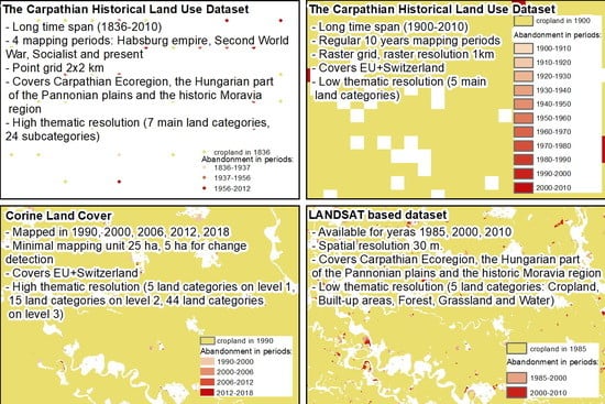
Figure 1 highlights the four data sources we employed to analyse land changes. The long-term changes were analysed from data derived from the HILDA model [57,58] and from the Historical Carpathian dataset [59], and short-term changes were analysed from CORINE Land Cover layers 1990, 2000, 2006, 2012 and 2018 [60] and Landsat satellite images [48].
The Carpathian Historical Land Use Dataset (CHLUD) was produced for the Carpathian Ecoregion, the Hungarian part of the Pannonian plains and the historic Moravia region [59]. The land use in Slovakia was mapped on a regular 2 × 2 km point grid for the following periods: (1) maps of the second Habsburg military survey from 1819–1858 at 1:28,800 scale were used for the Habsburg period; (2) national topographic maps from 1923–1941 at 1:20,000 to 1:100,000 covered the Second World War period; (3) 1954–1958 national topographic maps at 1:25,000 to 1:50,000 were employed for the Socialist period; (4) 2007–2014 aerial images mapped the recent period. The dataset contained seven main land use categories (Urban/Built-up, Agriculture, Grassland and Shrubs, Forest, Wetlands, Bare Land) and 24 subcategories. The investigated cropland areas included both seasonal and perennial agricultural classes, like orchards or vineyards [59]. Because the data are represented on a point grid of 2 × 2 km, one point represented 4 km2 in cropland area.
The Historic Land Dynamics Assessment (HILDA) model projects land cover changes for 1900–2010 at 10-year intervals from the aggregated CORINE 2000 dataset. The HILDA dataset contains five land cover classes: Settlements (including green urban areas), Cropland (including orchards and agro-forestry), Grassland (including natural grassland, wetlands, pasture and Mediterranean shrub vegetation), Forest (including transitional shrubs and woodlands, tree nurseries and reforested areas for forestry purposes), and Other Land (including glaciers, sparsely vegetated areas, beaches and water bodies) [57]. The land cover classes were allocated by down-scaling sub-national statistics to 1 km grid cells on probability maps. These were derived from historic maps for forest areas, and they empirically quantified location factors for the other land cover types [57]. The resulting land cover/land use maps provided the net changes, featuring direct changes from one class to another, while the gross changes covered non-directional changes and summarised all area gains and losses for the different land-cover types. Our analyses employed back-dated gross changes reconstructed for 1900–2010, and the examined cropland areas included orchards and agro-forestry areas [57].
The CORINE Land Cover [60] was mapped for 1990, 2000, 2006, 2012 and 2018, and land cover was identified by computer-aided visual interpretation of satellite images [56,61]. The minimal mapping unit was 25 ha for polygon delineation and 5 ha for land cover change detection, and analyses employed the land-cover change maps available on the Copernicus website (https://land.copernicus.eu/pan-european/CORINE-land-cover accessed on 24 March 2021). The dataset contains five main land-cover categories in nomenclature class 1 (Artificial Surfaces, Agricultural Areas, Forest and Semi-natural Areas, Wetlands, and Water Bodies), 15 land-cover categories in nomenclature class 2, and 44 land-cover categories in nomenclature class 3 [61]. For our analysis the cropland area included arable land, permanent crops and heterogeneous agricultural areas (pastures were not included).
The second source of recent changes was the Landsat dataset. Land cover maps, produced in 30 m resolution for 1985, 2000 and 2010, were generated by classifying the multi-seasonal Landsat image composites for the Carpathian Ecoregion, including all of Slovakia [48]. The Landsat images with cover cloud less than 70% were downloaded from the the United States Geological Survey Landsat archive, and the image composites that approximated spring, summer and fall seasonal states for the reference years were produced. The resulting composite contained 56 spectral bands (18 for each reference period) and an additional 27 bands of statistical metrics, capturing the spectral-temporal variability of a given pixel for each season. Five land cover/land use classes were classified using the Random forest classifier: Cropland, Built-up Areas, Forest, Grassland and Water. The cropland area ranged from large-scale cropland and intensively managed orchards, vineyards and hop fields to substance agriculture and kitchen gardens. The validation of the maps showed 90% overall accuracy [48].
For the validation of the investigated datasets, we used the cropland map from the Land Parcel Identification System (http://www.podnemapy.sk/lpis_verejnost/viewer.htm accessed on 24 March 2021). This system is a geo-database of agricultural parcels precisely mapped from aerial images, implemented for the allocation of agricultural subsidies [62]. We chose the LPIS data from 2010 because it was comparable with the analysed datasets recording the land cover/land use from 2010 or 2012. As a cropland we considered as classes arable land, hop gardens, vineyards, orchards, other agricultural land, and agricultural land.
Although permanent meadows and pastures are included in the definition of agricultural land [63], our study focused solely on cropland (Table 1). Here, we chose cropland because the analysed data sources do not distinguish between grasslands used agriculturally and natural grasslands not used for agriculture (for example, alpine meadows). Because of the low thematic resolution of the LANDSAT and HILDA datasets, we were not able to separate specific cropland categories (arable land, permanent crops, agricultural mosaics, vineyards and orchards) for a more detailed analyses. While different definitions of agricultural land abandonment depend on study context and content, the basic criterion for abandonment estimation is land cover/land use change. Agricultural land is generally considered abandoned when it no longer performs farming functions [22]. We consider all cropland types abandoned when they are changed to a different land cover/land use category (Table 1, Supplementary Figures S1–S4). These cropland types include arable land, permanent crops, agricultural mosaics, vineyards and orchards.
3. Results
3.1. Data Validation
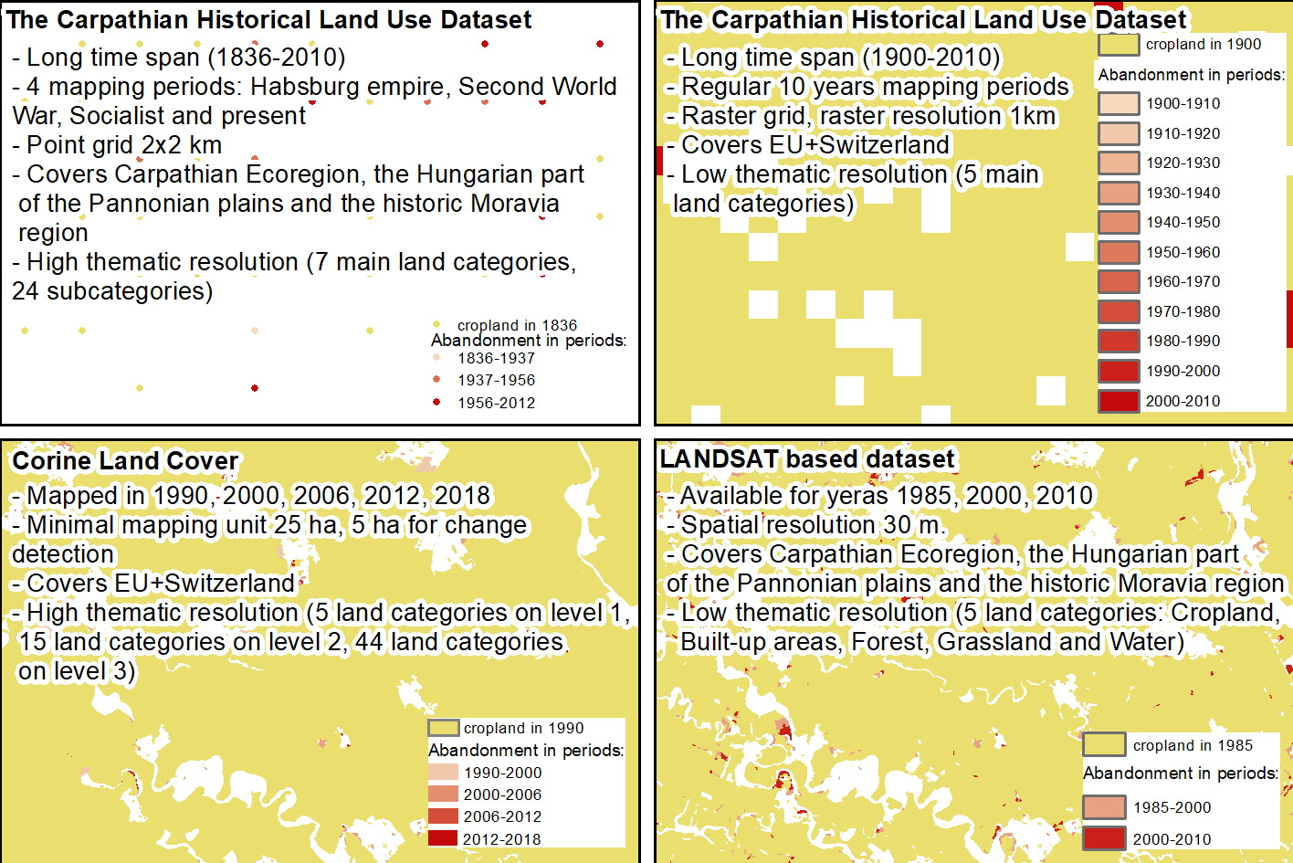
The most suitable records for the data validation and comparison were the records from 2010 and 2012 because cropland area was recorded in those years by all four investigated data sources (Figure 2). The largest 20,675 km2 area was reported by CORINE Land Cover (CLC), followed by Landsat with 16,199 km2, HILDA with 14,024 km2 and CHLUD with 13,536 km2. According to reference data from the Land Parcel Identification System (LPIS), the area of cropland covered 14,184 km2. Even the HILDA model estimated almost the same cropland area as LPIS; the lowest overlay was with the LPIS (69.6%) and high commission (22.67%) and omission rates (23.33%). The 1 km HILDA pixels could not identify the cropland in sufficient detail, and large areas were incorrectly included or excluded from cropland. The cropland area estimates of the CHLUD dataset were close to LPIS, with an overlay rate of (75.9%) and a commission rate of (16.30%). The omission rate was not calculated due to the point representation of the CHLUD dataset. CORINE Land Cover strongly overestimated the total cropland area; therefore, the commission rate was high (32.57%) and the omission rate was low (2.48%). The Landsat estimates were closer to the reference dataset, and the commission and omission rates were relatively low (11.62% and 11.98%, respectively). The validation showed that the most precise was the CHLUD dataset; therefore, it was more suitable for the long-term analyses. Both short-term datasets overestimated the cropland area; however, the Landsat data showed better accuracies (Table 2).
3.2. Cropland Area
The considerably larger area reported by CLC may be explained by its higher thematic resolution, recognising agricultural mosaics as a specific land cover class entitled “Heterogeneous agricultural areas”, which covers 4203 km2 and is still an important part of Slovak agriculture [64]. The remaining analysed land cover/land use datasets included agricultural mosaics in grassland, cropland, agricultural land or other categories. A further reason for higher CLC cropland area values could be the low CLC sensitivity to land cover change with consequent lower reflection of the agricultural land abandonment that occurred in Slovakia after 1990. The relatively higher values were also mapped by Landsat. The high spatial resolution images (30 m) recognized even small cropland fields, but there is possible inaccuracy in the remote sensing approach.
Both the CHLUD and HILDA long-term land cover datasets showed an increase in cropland area at the beginning of the study period. While the CHLUD dataset highlighted a decrease after 1938, the HILDA model depicted the decrease after 1990. The long-term statistical data showed a continual decrease in arable land after 1960 [36], and this was better reflected in the CHLUD dataset. All analysed datasets showed a decrease in cropland after 1990 due to transformation to a market-oriented economy [23,41]. Abandonment was more intensive in the first years of this transformation, and this was reflected in both CLC and Landsat datasets. The CHLUD dataset, however did not directly reflect the regime transformation because it lacked land cover data for the beginning of this period.
3.3. Abandonment Rates
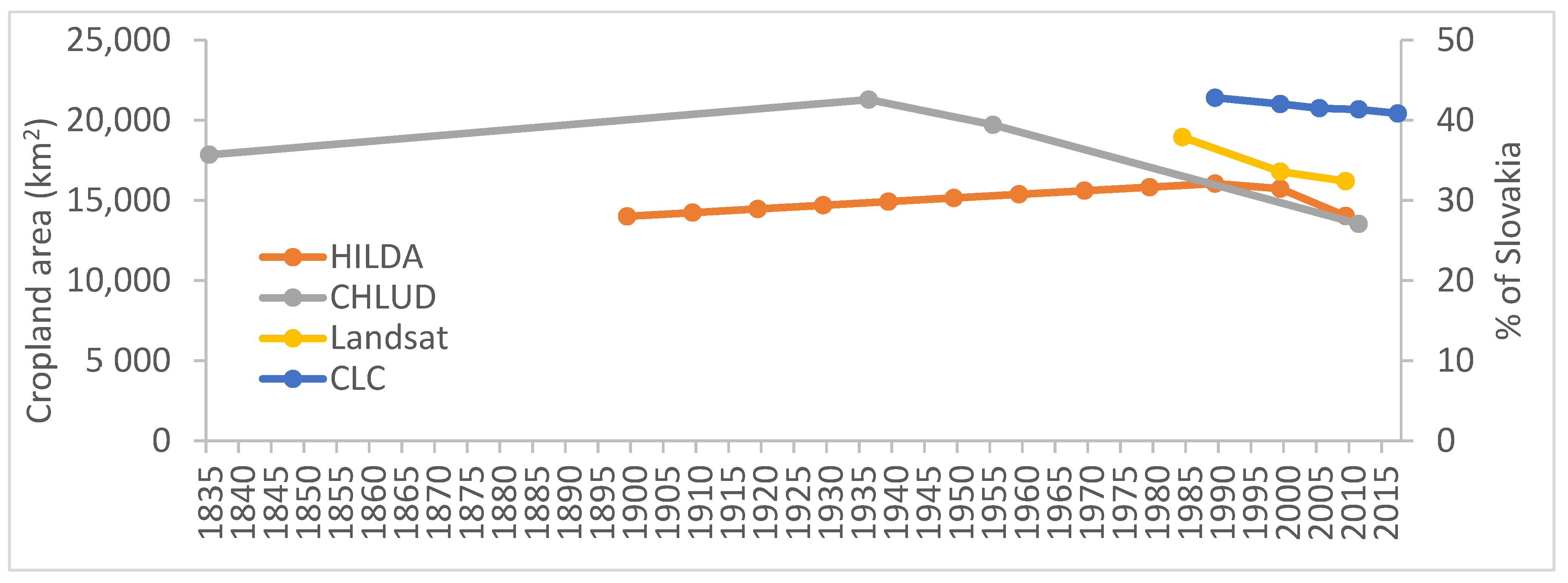
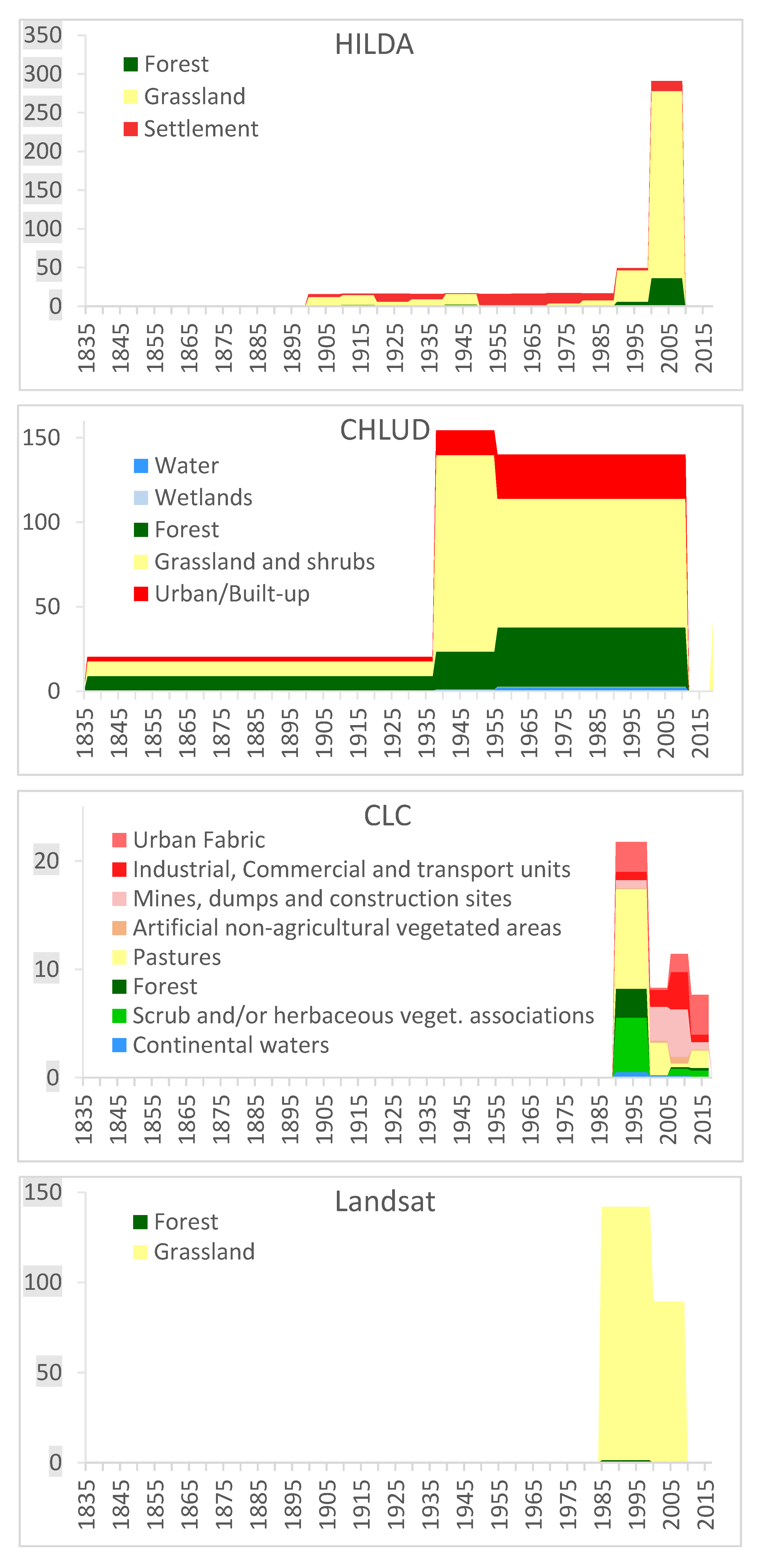
The HILDA model recorded the relatively stable 15–17 km2/year abandonment level until 1990. There was then a very sharp increase, ranging from 49.9 to 290.8 km2/year, following the change to a market-oriented economy (Figure 3). The Carpathian dataset for 1836–1937 had slightly higher values than HILDA’s 19.64 km2/year. There was then an increased abandonment of 154.44 km2/year during the Second World War, and a lower abandonment of 140.21 km2/year during communism and the market-oriented economy period.
The CLC reported the highest abandonment of 21.73 km2/year after 1990 and then a decrease and stabilisation after EU accession. The Landsat data recorded the same trend, though it had much higher values at 142.02 km2/year for 1985–1999 and 89.42 km2/year for 2000–2010.
3.4. Changes in Land Cover/Land Use
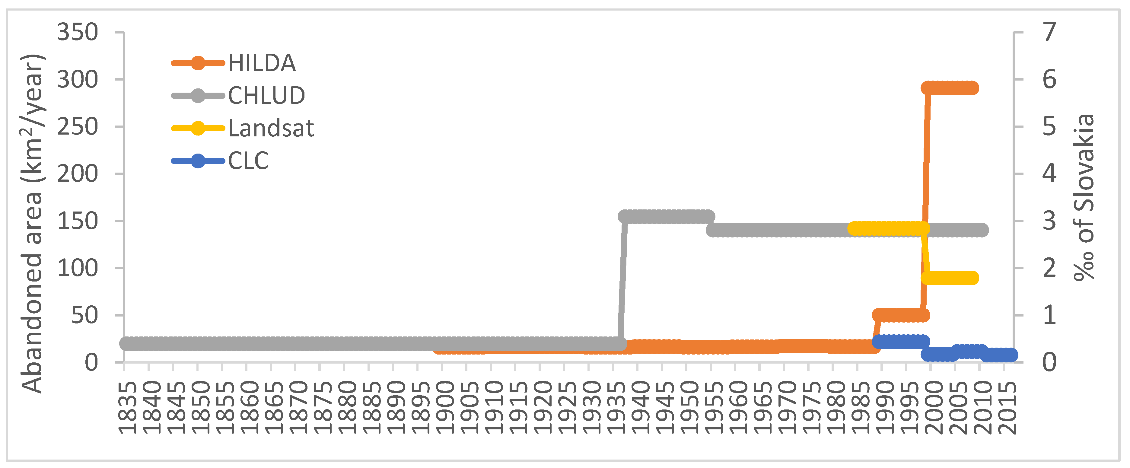
Prevailing conversions of cropland to grasslands were reported by all datasets, except the CLC, which reported prevailing conversion to grasslands only for 1990–2000 (Figure 4). The average percentage of cropland converted to grassland was 47.91% for the HILDA model (83.12% for 2000–2010), 49.40% for the CHLUD dataset (54.34% for 2000–2010), 28.02% for CLC (22.86% for 2000–2010) and 99.35% for the Landsat dataset (99.88% for 2000–2010). This prevailing conversion to grassland was expected because overgrowth by grasslands and shrubs is the natural consequence of cropland abandonment.
The second most important change was the conversion to forest: this was 8.29% for the HILDA model (12.48% for 2000–2010), 34.35% for the CHLUD dataset (24.95% for 2000–2010), 5.32% for CLC (0.57% for 2000–2010) and 0.65% for the Landsat data (0.12% for 2000–2010). The third most pronounced change was conversion to urban areas: this was 43.80% for the HILDA model (4.4% for 2000–2010), 14.56% for the CHLUD dataset (18.67% for 2000–2010) and 53.49% for CLC (71.97 for 2000–2010). The Landsat data did not map conversion to urban areas.
The CLC layers had a lower proportion of conversion to grasslands and a higher proportion of conversion to cropland. Part of the abandoned cropland was also recognized as “Scrub and/or herbaceous vegetation associations”, while other datasets included shrubs under grasslands or the forest category. The high proportion of urbanised area may be explained by lower sensitivity to small land cover changes. Abandonment often occurred on small areas under CLC resolution, but urbanisation occurred on large blocks recognized by CLC. In contrast, the Landsat dataset showed only minor parts of areas converted to forest, and it did not reflect urbanisation. Therefore, Landsat was less suitable for analysis of cropland conversion areas, and we consider that the total abandonment rates reported by Landsat would be higher if the dataset included urbanisation and provided more precise information on afforestation.
4. Discussion
Herein, we analysed cropland abandonment in Slovakia from four different datasets: The Historic Land Dynamics Assessment, the Carpathian Historical Land Use Dataset, the CORINE Land Cover dataset and the Landsat images classification. These datasets have different origins, cover different time periods and have different spatial, temporal and thematic resolution; these differences must therefore be considered in interpreting our analytic results. The historic Carpathian dataset is unique because it describes existing land use from the Austro-Hungarian monarchy era. However, this first 1836–1937 period covers 100 years, and it provides no information on land changes within this time period. The collapse of the Austro-Hungarian monarchy, the First World War and the altered land-management regime from the “Innovations and Rights to Intensification” at the end of 19th century [65] certainly influenced land change trajectories [66]. Land change intensity was generally lower in the past [67,68], and this was confirmed by our results. The second period of the historic Carpathian dataset then covers the effect of the Second World War. Armed conflicts can lead to both more intensive and less intensive land use [69]; the historical Carpathian dataset highlights increased cropland abandonment at this time.
The HILDA model is advantageous here because it records historic land cover/land use in 10-year intervals from 1900. Its data, however, are based on modelling [57,58]; this can initiate uncertainties, errors and inconsistencies, as was seen in comparison with the Land Parcel Identification System data. For example, the HILDA model reported an increase of the abandonment rates in 1990–2000 (49.9 km2/year) and an extreme peak in the period 2000–2010 (290.8 km2/year). Increased abandonment after transition to a market-oriented economy in the period 1990–2000, followed by a decrease due to EU accession support in the period 2000–2010, was reported for Slovakia [36,41,43] and for other post-socialistic countries [24,70,71]. Because of the uncertainties related to historical land cover modelling and because of the validation results, we consider that the CHLUD dataset is a more reliable long-term data source. Visual interpretation of historic maps and aerial images employed in CHLUD mapping [59] is considered as a reliable method for historical land cover/land use mapping [1,72,73]. Although we consider HILDA model as a useful data source, especially for analyses at the European level [72,74], we prefer the historic Carpathian dataset for overall interpretation of long-term land changes.
The CORINE Land Cover dataset [26,75,76] and the Landsat images [2,77,78] were used for analysing the land use changes in various countries. The advantage of the CLC is its detailed temporal and thematic resolution, but it has the disadvantage of low spatial resolution and low sensitivity to land cover change [41,79], especially for arable land and permanent grasslands [80]. Therefore, the CLC is suitable for describing the trends, locality and relative magnitude of change, while the Landsat data based on the images with 30 m spatial resolution is more appropriate for estimation of the actual magnitude of change. This is clearly noticeable in our comparison, where the magnitudes of land changes mapped from the Landsat were sometimes more than 10 times higher than those analysed from CLC. The comparison of both datasets with the data from the Land Parcel Identification system showed that the Landsat data were more precise. However, the low thematic resolution still remains a disadvantage of the analysed Landsat dataset, and the definitions of land change processes are less complex than those in CLC.
The results of land change analyses depend on spatial resolution (more detailed data bring more changes, as was noticed from a comparison of CLC with the Landsat data), temporal resolution (if the time periods are too long, some areas could survive more changes) and thematic resolutions of the data sources. The definitions of the analysed land change processes need to be considered as well. The definition of agricultural land abandonment is vague and dependent on approach and on context for different studies [22]. Some studies [8,73] use exclusive definitions of the process, where one type of land cover/land use change could be the subject of one process (for example, change of arable land to an urban area is exclusively defined as urbanisation, while it could be also defined as agricultural land abandonment). This must be considered when interpreting the analytic results of landscape changes.
For our analysis, we used data from historical maps and historical land-cover models as well as the data derived from optical remote sensing products. The use of additional data sources like historical cadastral data [70,81] or pollen data [82] could reveal more information about the historical development of agriculture. The recent agricultural land abandonment could be also analysed from available global land cover products like MODIS Land Cover [83] or from LiDAR data [27,84].
5. Conclusions
In this study we compared different nationwide multi-temporal spatial data sources and analysed the cropland area, cropland abandonment rates and transformation of cropland to other land cover/land use categories in Slovakia. We combined the information from different datasets to obtain an overall picture of long-term cropland abandonment in Slovakia.
The comparison of investigated datasets with the detailed cropland data from the Land Parcel Identification System showed that most accurate dataset is the Historic Carpathian Land Use dataset. The CORINE Land Cover dataset and data derived from Landsat images overestimates the cropland area, but the Landsat data are more accurate.
The Historic Carpathian Land Use dataset (CHLUD) is most reliable for long-term land change analyses. This provides an average of 19.65 km2/year cropland abandonment in 1836–1937 and 154.44 km2/year in 1938–1955. The average abandonment rate for 1956–2012 is 140.21 km2/year, but this average includes the increased abandonment following transition to the market economy after 1989. Here, the Landsat data records 142.02 km2/year for 1985–2000 and 89.42 km2/year for 2000–2010, but it does not include urbanisation and maps only a minor part of afforestation. Therefore the total abandonment rates for 1985–2010 are most likely 20–40% higher than CHLUD records. In contrast, the 290.8 km2/year abandonment for 2000–2010 recorded by the HILDA model appears overestimated and the 49.9 km2/year for 1990–2000 is under-estimated when abandonment associated with the 1989 market economy is considered. The CORINE Land Cover data show substantially lower values due the low sensitivity to land cover changes and are not suitable for quantification of the land cover changes. The advantage of CORINE Land Cover is the high thematic and temporal resolution; therefore, it is suitable for mapping the spatial distribution of land cover changes and the relative magnitudes of changes.
Total cropland area increased during the 19th century and the first half of the 20th century, but then decreased after the Second World War and the transition to communism. This was followed by a greater decrease after the 1989 transition to the market economy. The different datasets vary in their estimates of cropland area as follows: the HILDA model has 14,024 km2 for 2010; the Carpathian Historic dataset records 13,536 km2 for 2012; the Landsat has 16,199 km2 for 2010; the CORINE Land Cover has 20,675 km2 for 2012. In addition, the Land Parcel Identification System, which is a precise database based on interpreting aerial images for the allocation of agricultural subsidies, registered 14,506 km2 of cropland area in 2011. Different investigated data sources record varying percentages of land cover/land use transformation in different periods, but the recorded transformations are mostly from cropland to grassland. The Carpathian Historical Database allocates transformation to different categories, with 49% conversion to grassland, 34% to forest and 15% to urban areas. The CORINE Land Cover data show increased urbanisation in last years; however, the 61–88% urbanisation seems to be overestimated.
The long term land cover/land use data based on vectorization of historical digital sources has proven more reliable than the data based on modelling. The historical sources are limited by their availability in certain time steps. The potential for improvement is the digitalization of other existing data sources (for example, in Slovakia, the aerial photos from half of 1960s and the end of 1980s are not digitized). However, there will be still gaps for certain, especially older, time periods; this provides an opportunity for the modelling techniques. The recent data based on classification of satellite images are detailed and precise, but limited in their thematic resolution. With the advances in remote sensing sensors and techniques, the quality of remote sensing products continues to improve, and feature datasets will be more applicable for detailed land change analyses.
Supplementary Materials
The following are available online at https://www.mdpi.com/article/10.3390/land10040334/s1, Figure S1: Cropland abandonment derived from the Carpathian Historical Land Use Dataset, Figure S2: Cropland abandonment derived from the Historic Land Dynamics Assessment model, Figure S3: Cropland abandonment derived from the CORINE Land Cover, Figure S4: Cropland abandonment derived from Landsat images.
Author Contributions
Conceptualization, J.L.; methodology, J.L.; formal analysis, J.L.; investigation, D.L.; resources, D.L. and J.L.; data curation, J.L.; writing—original draft preparation, D.L. and J.L.; writing—review and editing, J.L.; visualization, J.L. Both authors have read and agreed to the published version of the manuscript.
Funding
This research was funded by EU FP7 ERA.Net Russia Plus (grant number: 449 CLIMASTEPPE) and the Slovak Scientific Grant Agency VEGA 2/0018/19 “Ecological Analyses of Landscape Acculturation in Slovakia since Early Prehistory until Today” and by the Integrated Infrastructure Operational Programme funded by the ERDF, project ITMS2014+ 313011W580, Scientific support of climate change adaptation in agriculture and mitigation of soil degradation.
Institutional Review Board Statement
Not applicable.
Informed Consent Statement
Not applicable.
Data Availability Statement
The Carpathian Historical Land Use Dataset is attached as Supplementary Materials to the study: Lieskovský, J.; Kaim, D.; Balázs, P.; Boltižiar, M.; Chmiel, M.; Grabska, E.; Király, G.; Konkoly-Gyuró, É.; Kozak, J.; Antalová, K.; et al. Historical Land Use Dataset of the Carpathian Region (1819–1980). Journal of Maps 2018, 14, 644–651, doi:10.1080/17445647.2018.1502099. The manuscript and data are available at https://www.tandfonline.com/doi/full/10.1080/17445647.2018.1502099 (accessed on 24 March 2021). The Historic Land Dynamics Assessment (HILDA) dataset is available at the Wageningen University & Research webpage https://www.wur.nl/en/Research-Results/Chair-groups/Environmental-Sciences/Laboratory-of-Geo-information-Science-and-Remote-Sensing/Models/Hilda/HILDA-data-downloads.htm (accessed on 24 March 2021). Corine Land Cover is available at the Copernicus Services website https://land.copernicus.eu/pan-european/corine-land-cover (accessed on 24 March 2021). The Landsat dataset is an output of the paper: Griffiths, P.; Müller, D.; Kuemmerle, T.; Hostert, P. Agricultural Land Change in the Carpathian Ecoregion after the Breakdown of Socialism and Expansion of the European Union. Environmental Research Letters 2013, 8, 12, doi:10.1088/1748-9326/8/4/045024. The paper is available at https://iopscience.iop.org/article/10.1088/1748-9326/8/4/045024 (accessed on 24 March 2021). The current version of the Land Parcel Identification System is available at the Central Portal of Public Services of National Agency for Network and Electronic Services https://data.gov.sk/en/dataset/system-identifikacie-polnohospodarskych-pozemkov-lpis (accessed on 24 March 2021).
Acknowledgments
We thank Patrick Griffiths for the provision of the agricultural land-cover change dataset derived from Landsat images.
Conflicts of Interest
The authors declare no conflict of interest.
References
- Blair, D.; Shackleton, C.; Mograbi, P. Cropland Abandonment in South African Smallholder Communal Lands: Land Cover Change (1950–2010) and Farmer Perceptions of Contributing Factors. Land 2018, 7, 121. [Google Scholar] [CrossRef]
- Yin, H.; Brandão, A.; Buchner, J.; Helmers, D.; Iuliano, B.G.; Kimambo, N.E.; Lewińska, K.E.; Razenkova, E.; Rizayeva, A.; Rogova, N.; et al. Monitoring Cropland Abandonment with Landsat Time Series. Remote Sens. Environ. 2020, 246, 111873. [Google Scholar] [CrossRef]
- Lesiv, M.; Schepaschenko, D.; Moltchanova, E.; Bun, R.; Dürauer, M.; Prishchepov, A.V.; Schierhorn, F.; Estel, S.; Kuemmerle, T.; Alcántara, C.; et al. Spatial Distribution of Arable and Abandoned Land across Former Soviet Union Countries. Sci. Data 2018, 5, 180056. [Google Scholar] [CrossRef] [PubMed]
- Wang, C.; Gao, Q.; Wang, X.; Yu, M. Spatially Differentiated Trends in Urbanization, Agricultural Land Abandonment and Reclamation, and Woodland Recovery in Northern China. Sci. Rep. 2016, 6, 37658. [Google Scholar] [CrossRef] [PubMed]
- Drummond, M.A.; Loveland, T.R. Land-Use Pressure and a Transition to Forest-Cover Loss in the Eastern United States. BioScience 2010, 60, 286–298. [Google Scholar] [CrossRef]
- Lugo, A.E.; Helmer, E. Emerging Forests on Abandoned Land: Puerto Rico’s New Forests. For. Ecol. Manag. 2004, 190, 145–161. [Google Scholar] [CrossRef]
- Bürgi, M.; Bieling, C.; von Hackwitz, K.; Kizos, T.; Lieskovský, J.; Martín, M.G.; McCarthy, S.; Müller, M.; Palang, H.; Plieninger, T.; et al. Processes and Driving Forces in Changing Cultural Landscapes across Europe. Landsc. Ecol. 2017, 32, 2097–2112. [Google Scholar] [CrossRef]
- Feranec, J.; Soukup, T.; Taff, G.N.; Stych, P.; Bicik, I. Overview of Changes in Land Use and Land Cover in Eastern Europe. In Land-Cover and Land-Use Changes in Eastern Europe after the Collapse of the Soviet Union in 1991; Gutman, G., Radeloff, V., Eds.; Springer International Publishing: Cham, Switzerland, 2017; pp. 13–33. ISBN 978-3-319-42636-5. [Google Scholar]
- Levers, C.; Müller, D.; Erb, K.; Haberl, H.; Jepsen, M.R.; Metzger, M.J.; Meyfroidt, P.; Plieninger, T.; Plutzar, C.; Stürck, J.; et al. Archetypical Patterns and Trajectories of Land Systems in Europe. Reg. Environ. Chang. 2015. [Google Scholar] [CrossRef]
- Schulp, C.J.E.; Levers, C.; Kuemmerle, T.; Tieskens, K.F.; Verburg, P.H. Mapping and Modelling Past and Future Land Use Change in Europe’s Cultural Landscapes. Land Use Policy 2018. [Google Scholar] [CrossRef]
- Prishchepov, A.V.; Radeloff, V.C.; Baumann, M.; Kuemmerle, T.; Müller, D. Effects of Institutional Changes on Land Use: Agricultural Land Abandonment during the Transition from State-Command to Market-Driven Economies in Post-Soviet Eastern Europe. Environ. Res. Lett. 2012, 7, 024021. [Google Scholar] [CrossRef]
- Kenderessy, P.; Kollár, J.; Palaj, A. The Impact of Historical Agricultural Landuse on Selected Site Conditions in the Traditional Landscape of the West Carpathians. Ekologia 2020, 39, 343–356. [Google Scholar] [CrossRef]
- Slamova, M.; Chudy, F.; Tomastik, J.; Kardos, M.; Modransky, J. Historical Terraces—Current Situation and Future Perspectives for Optimal Land Use Management: The Case Study of Cierny Balog. Ann. Anal. Istrske Mediter. 2019, 29, 85–100. [Google Scholar] [CrossRef]
- Vinogradovs, I.; Nikodemus, O.; Elferts, D.; Brumelis, G. Assessment of Site-Specific Drivers of Farmland Abandonment in Mosaic-Type Landscapes: A Case Study in Vidzeme, Latvia. Agric. Ecosyst. Environ. 2018, 253, 113–121. [Google Scholar] [CrossRef]
- Bugár, G.; Pucherová, Z.; Veselovská, K. Mosaic Landscape Structures in Relation to the Land Use of Nitra District. Ekológia 2020, 39, 277–288. [Google Scholar] [CrossRef]
- Rendeková, A.; Miškovic, J.; Mičieta, K.; Michalová, M.; Eliašová, M.; Ballová, D. Changes in the Diversity of Dry Calcareous Grasslands After Abandonment of Traditional Management in Devínska Kobyla National Nature Reserve (Southwestern Slovakia, Central Europe). Ekológia 2020, 39, 101–115. [Google Scholar] [CrossRef]
- Klimantová, A. Ecological Evaluation of Grassland Vegetation in Hodrušská Hornatina Highland. Ekológia 2020, 39, 236–249. [Google Scholar] [CrossRef]
- Ceauşu, S.; Carver, S.; Verburg, P.H.; Kuechly, H.U.; Hölker, F.; Brotons, L.; Pereira, H.M. European Wilderness in a Time of Farmland Abandonment. In Rewilding European Landscapes; Pereira, H.M., Navarro, L.M., Eds.; Springer International Publishing: Cham, Switzerland, 2015; pp. 25–46. ISBN 978-3-319-12038-6. [Google Scholar]
- Ortyl, B.; Ćwik, A.; Kasprzyk, I. What Happens in a Carpathian Catchment after the Sudden Abandonment of Cultivation? CATENA 2018, 166, 158–170. [Google Scholar] [CrossRef]
- Skalský, R.; Koco, Š.; Barančíková, G.; Tarasovičová, Z.; Halas, J.; Koleda, P.; Makovníková, J.; Gutteková, M.; Tobiášová, E.; Gömöryová, E.; et al. Land Cover and Land Use Change-Driven Dynamics of Soil Organic Carbon in North-East Slovakian Croplands and Grasslands Between 1970 and 2013. Ekológia 2020, 39, 159–173. [Google Scholar] [CrossRef]
- van der Zanden, E.H.; Verburg, P.H.; Schulp, C.J.E.; Verkerk, P.J. Trade-Offs of European Agricultural Abandonment. Land Use Policy 2017, 62, 290–301. [Google Scholar] [CrossRef]
- Goga, T.; Feranec, J.; Bucha, T.; Rusnák, M.; Sačkov, I.; Barka, I.; Kopecká, M.; Papčo, J.; Oťaheľ, J.; Szatmári, D.; et al. A Review of the Application of Remote Sensing Data for Abandoned Agricultural Land Identification with Focus on Central and Eastern Europe. Remote Sens. 2019, 11, 2759. [Google Scholar] [CrossRef]
- Kuemmerle, T.; Hostert, P.; Radeloff, V.C.; Linden, S.; Perzanowski, K.; Kruhlov, I. Cross-Border Comparison of Post-Socialist Farmland Abandonment in the Carpathians. Ecosystems 2008, 11, 614–628. [Google Scholar] [CrossRef]
- Munteanu, C.; Kuemmerle, T.; Boltiziar, M.; Butsic, V.; Gimmi, U.; Halada, L.; Kaim, D.; Király, G.; Konkoly-Gyuró, É.; Kozak, J.; et al. Forest and Agricultural Land Change in the Carpathian Region—A Meta-Analysis of Long-Term Patterns and Drivers of Change. Land Use Policy 2014, 38, 685–697. [Google Scholar] [CrossRef]
- Săvulescu, I.; Mihai, B.-A.; Vîrghileanu, M.; Nistor, C.; Olariu, B. Mountain Arable Land Abandonment (1968–2018) in the Romanian Carpathians: Environmental Conflicts and Sustainability Issues. Sustainability 2019, 11, 6679. [Google Scholar] [CrossRef]
- Petrişor, A.-I.; Sirodoev, I.; Ianoş, I. Trends in the National and Regional Transitional Dynamics of Land Cover and Use Changes in Romania. Remote Sens. 2020, 12, 230. [Google Scholar] [CrossRef]
- Kolecka, N.; Kozak, J. Wall-to-Wall Parcel-Level Mapping of Agricultural Land Abandonment in the Polish Carpathians. Land 2019, 8, 129. [Google Scholar] [CrossRef]
- Halada, L.; David, S.; Hreško, J.; Klimantová, A.; Bača, A.; Rusňák, T.; Bural, M.; Vadel, L. Changes in Grassland Management and Plant Diversity in a Marginal Region of the Carpathian Mts. in 1999–2015. Sci. Total Environ. 2017, 609, 896–905. [Google Scholar] [CrossRef]
- Meyfroidt, P.; Schierhorn, F.; Prishchepov, A.V.; Müller, D.; Kuemmerle, T. Drivers, Constraints and Trade-Offs Associated with Recultivating Abandoned Cropland in Russia, Ukraine and Kazakhstan. Glob. Environ. Chang. 2016, 37, 1–15. [Google Scholar] [CrossRef]
- Smaliychuk, A.; Müller, D.; Prishchepov, A.V.; Levers, C.; Kruhlov, I.; Kuemmerle, T. Recultivation of Abandoned Agricultural Lands in Ukraine: Patterns and Drivers. Glob. Environ. Chang. 2016, 38, 70–81. [Google Scholar] [CrossRef]
- Izakovičová, Z.; Oszlányi, J. The landscape of Slovakia, its nature and transformations. In Lost landscapes: Reflections from Central European Border Regions; Elmar, C., Ed.; Regional Development Agency Mura: Murska Sobota, Slovenia, 2012; pp. 115–131. ISBN 978-961-93442-1-7. [Google Scholar]
- Kanianska, R.; Kizeková, M.; Nováček, J.; Zeman, M. Land-Use and Land-Cover Changes in Rural Areas during Different Political Systems: A Case Study of Slovakia from 1782 to 2006. Land Use Policy 2014, 36, 554–566. [Google Scholar] [CrossRef]
- Prokopová, M.; Cudlín, O.; Včeláková, R.; Lengyel, S.; Salvati, L.; Cudlín, P. Latent Drivers of Landscape Transformation in Eastern Europe: Past, Present and Future. Sustainability 2018, 10, 2918. [Google Scholar] [CrossRef]
- Lieskovský, J.; Bezák, P.; Špulerová, J.; Lieskovský, T.; Koleda, P.; Dobrovodská, M.; Bürgi, M.; Gimmi, U. The Abandonment of Traditional Agricultural Landscape in Slovakia—Analysis of Extent and Driving Forces. J. Rural Stud. 2015, 37, 75–84. [Google Scholar] [CrossRef]
- Špulerová, J.; Dobrovodská, M.; Lieskovský, J.; Bača, A.; Halabuk, A.; Kohút, F.; Mojses, M.; Kenderessy, P.; Piscová, V.; Barančok, P.; et al. Inventory and Classification of Historical Structures of the Agricultural Landscape in Slovakia. Ekologia 2011, 30, 157–170. [Google Scholar] [CrossRef]
- Bezák, P.; Mitchley, J. Drivers of Change in Mountain Farming in Slovakia: From Socialist Collectivisation to the Common Agricultural Policy. Reg. Environ. Chang. 2014, 14, 1343–1356. [Google Scholar] [CrossRef]
- Feranec, J.; Šúri, M.; Ot’ahel’, J.; Cebecauer, T.; Kolář, J.; Soukup, T.; Zdeňková, D.; Waszmuth, J.; Vâjdea, V.; Vîjdea, A.-M.; et al. Inventory of Major Landscape Changes in the Czech Republic, Hungary, Romania and Slovak Republic 1970s–1990s. Int. J. Appl. Earth Obs. Geoinf. 2000, 2, 129–139. [Google Scholar] [CrossRef]
- Pazúr, R.; Lieskovský, J.; Feranec, J.; Oťaheľ, J. Spatial Determinants of Abandonment of Large-Scale Arable Lands and Managed Grasslands in Slovakia during the Periods of Post-Socialist Transition and European Union Accession. Appl. Geogr. 2014, 54, 118–128. [Google Scholar] [CrossRef]
- Blažík, T.; Falťan, V.; Tarasovicová, Z.; Saksa, M. Zmeny využitia zeme vybraných okresov rôznych poľnohospodárskych produkčných oblastí v kontexte prebiehajúcich transformačných procesov. Geogr. Časopis 2011, 63, 301–323. [Google Scholar]
- Némethová, J.; Dubcová, A.; Kramáreková, H. The Impacts of the European Union’s Common Agricultural Policy on Agriculture in Slovakia/Dopady Společné Zemědělské Politiky Evropské Unie Na Zemědělství Slovenska. Morav. Geogr. Rep. 2014, 22. [Google Scholar] [CrossRef]
- Pazúr, R.; Bolliger, J. Land Changes in Slovakia: Past Processes and Future Directions. Appl. Geogr. 2017, 85, 163–175. [Google Scholar] [CrossRef]
- Pe’er, G.; Zinngrebe, Y.; Moreira, F.; Sirami, C.; Schindler, S.; Müller, R.; Bontzorlos, V.; Clough, D.; Bezák, P.; Bonn, A.; et al. A Greener Path for the EU Common Agricultural Policy. Science 2019, 365, 449–451. [Google Scholar] [CrossRef]
- Pazúr, R.; Lieskovský, J.; Bürgi, M.; Müller, D.; Lieskovský, T.; Zhang, Z.; Prischchepov, A.V. Abandonment and Recultivation of Agricultural Lands in Slovakia—Patterns and Determinants from the Past to the Future. Land 2020, 9, 316. [Google Scholar] [CrossRef]
- Dobrovodská, M.; Kanka, R.; David, S.; Kollár, J.; Špulerová, J.; Štefunková, D.; Mojses, M.; Petrovič, F.; Krištín, A.; Stašiov, S.; et al. Assessment of the Biocultural Value of Traditional Agricultural Landscape on a Plot-by-Plot Level: Case Studies from Slovakia. Biodivers Conserv. 2019, 28, 2615–2645. [Google Scholar] [CrossRef]
- Slámová, M.; Belčáková, I. The Role of Small Farm Activities for the Sustainable Management of Agricultural Landscapes: Case Studies from Europe. Sustainability 2019, 11, 5966. [Google Scholar] [CrossRef]
- Špulerová, J.; Dobrovodská, M.; Štefunková, D.; Bača, A.; Lieskovský, J. Biodiversity of Traditional Agricultural Landscapes in Slovakia and Their Threats. In Biocultural Landscapes; Hong, S.-K., Bogaert, J., Min, Q., Eds.; Springer: Dordrecht, The Netherlands, 2014; pp. 113–128. ISBN 978-94-017-8940-0. [Google Scholar]
- Estel, S.; Kuemmerle, T.; Alcántara, C.; Levers, C.; Prishchepov, A.; Hostert, P. Mapping Farmland Abandonment and Recultivation across Europe Using MODIS NDVI Time Series. Remote Sens. Environ. 2015, 163, 312–325. [Google Scholar] [CrossRef]
- Griffiths, P.; Müller, D.; Kuemmerle, T.; Hostert, P. Agricultural Land Change in the Carpathian Ecoregion after the Breakdown of Socialism and Expansion of the European Union. Environ. Res. Lett. 2013, 8, 12. [Google Scholar] [CrossRef]
- Kristensen, S.B.P.; Busck, A.G.; van der Sluis, T.; Gaube, V. Patterns and Drivers of Farm-Level Land Use Change in Selected European Rural Landscapes. Land Use Policy 2016, 57, 786–799. [Google Scholar] [CrossRef]
- Terres, J.-M.; Scacchiafichi, L.N.; Wania, A.; Ambar, M.; Anguiano, E.; Buckwell, A.; Coppola, A.; Gocht, A.; Källström, H.N.; Pointereau, P.; et al. Farmland Abandonment in Europe: Identification of Drivers and Indicators, and Development of a Composite Indicator of Risk. Land Use Policy 2015, 49, 20–34. [Google Scholar] [CrossRef]
- van Vliet, J.; de Groot, H.L.; Rietveld, P.; Verburg, P.H. Manifestations and Underlying Drivers of Agricultural Land Use Change in Europe. Landsc. Urban Plan. 2015, 133, 24–36. [Google Scholar] [CrossRef]
- Masný, M.; Weis, K.; Boltižiar, M. Agricultural Abandonment in Chosen Terrain Attributes Context – Case Study from the Poľana Unesco Biosphere Reserve (Central Slovakia). Ekológia 2017, 36, 339–351. [Google Scholar] [CrossRef]
- García-Martín, M.; Quintas-Soriano, C.; Torralba, M.; Wolpert, F.; Plieninger, T. Landscape Change in Europe. In Sustainable Land Management in a European Context: A Co-Design Approach; Weith, T., Barkmann, T., Gaasch, N., Rogga, S., Strauß, C., Zscheischler, J., Eds.; Human-Environment Interactions; Springer International Publishing: Cham, Switzerland, 2021; pp. 17–37. ISBN 978-3-030-50841-8. [Google Scholar]
- Lasanta, T.; Arnáez, J.; Pascual, N.; Ruiz-Flaño, P.; Errea, M.P.; Lana-Renault, N. Space–Time Process and Drivers of Land Abandonment in Europe. CATENA 2017, 149, 810–823. [Google Scholar] [CrossRef]
- Levers, C.; Schneider, M.; Prishchepov, A.V.; Estel, S.; Kuemmerle, T. Spatial Variation in Determinants of Agricultural Land Abandonment in Europe. Sci. Total Environ. 2018, 644, 95–111. [Google Scholar] [CrossRef] [PubMed]
- Feranec, J.; Nováček, J. The Corine Land Cover Database of Slovakia and Its Changes in the Period 2000–2006. Morav. Geogr. Rep. 2009, 17, 2–10. [Google Scholar]
- Fuchs, R.; Herold, M.; Verburg, P.H.; Clevers, J.G.P.W. A High-Resolution and Harmonized Model Approach for Reconstructing and Analysing Historic Land Changes in Europe. Biogeosciences 2013, 10, 1543–1559. [Google Scholar] [CrossRef]
- Fuchs, R.; Herold, M.; Verburg, P.H.; Clevers, J.G.P.W.; Eberle, J. Gross Changes in Reconstructions of Historic Land Cover/Use for Europe between 1900 and 2010. Glob. Chang. Biol. 2015, 21, 299–313. [Google Scholar] [CrossRef]
- Lieskovský, J.; Kaim, D.; Balázs, P.; Boltižiar, M.; Chmiel, M.; Grabska, E.; Király, G.; Konkoly-Gyuró, É.; Kozak, J.; Antalová, K.; et al. Historical Land Use Dataset of the Carpathian Region (1819–1980). J. Maps 2018, 14, 644–651. [Google Scholar] [CrossRef]
- European Environmental Agency (EEA). Corine Land Cover (CLC) 2018; Version 20; EEA: Copenhagen, Denmark, 2019. [Google Scholar]
- Bossard, M.; Feranec, J.; Otahel’, J. CORINE Land Cover Technical Guide—Addendum 2000; European Environment Agency: Copenhagen, Denmark, 2000; p. 105. [Google Scholar]
- Zverková, A.; Sviček, M. Slovak Land Parcel Identification System. In Proceedings of the 1st International Congress on Soil Science, XIII National Congress in Soil Science, Soil–Water–Plant, Belgrade, Serbia, 23–26 September 2013. [Google Scholar]
- FAO Food and Agriculture Organization of the United Nations (FAO). FAOSTAT—Statistical Database on Land Use. Available online: http://www.fao.org/ag/agn/nutrition/Indicatorsfiles/Agriculture.pdf (accessed on 1 July 2020).
- Špulerová, J.; Bezák, P.; Dobrovodská, M.; Lieskovský, J.; Štefunková, D. Traditional Agricultural Landscapes in Slovakia: Why Should We Preserve Them? Landsc. Res. 2017, 42, 891–903. [Google Scholar] [CrossRef]
- Jepsen, M.R.; Kuemmerle, T.; Müller, D.; Erb, K.; Verburg, P.H.; Haberl, H.; Vesterager, J.P.; Andrič, M.; Antrop, M.; Austrheim, G.; et al. Transitions in European Land-Management Regimes between 1800 and 2010. Land Use Policy 2015, 49, 53–64. [Google Scholar] [CrossRef]
- Müller, D.; Sun, Z.; Vongvisouk, T.; Pflugmacher, D.; Xu, J.; Mertz, O. Regime Shifts Limit the Predictability of Land-System Change. Glob. Environ. Chang. 2014, 28, 75–83. [Google Scholar] [CrossRef]
- Antrop, M. Why Landscapes of the Past Are Important for the Future. Landsc. Urban Plan. 2005, 70, 21–34. [Google Scholar] [CrossRef]
- Vos, W.; Meekes, H. Trends in European Cultural Landscape Development: Perspectives for a Sustainable Future. Landsc. Urban Plan. 1999, 46, 3–14. [Google Scholar] [CrossRef]
- Baumann, M.; Kuemmerle, T. The Impacts of Warfare and Armed Conflict on Land Systems. J. Land Use Sci. 2016, 11, 672–688. [Google Scholar] [CrossRef]
- Janoušek, Z. Ztráty zemědělské půdy po roce 1990 v Libereckém kraji. Geografe 2018, 123, 253–278. [Google Scholar] [CrossRef]
- Müller, D.; Kuemmerle, T.; Rusu, M.; Griffiths, P. Lost in Transition: Determinants of Post-Socialist Cropland Abandonment in Romania. J. Land Use Sci. 2009, 4, 109–129. [Google Scholar] [CrossRef]
- Lieskovský, J.; Bürgi, M. Persistence in Cultural Landscapes: A Pan-European Analysis. Reg. Environ. Chang. 2018, 18, 175–187. [Google Scholar] [CrossRef]
- Gerard, F.; Petit, S.; Smith, G.; Thomson, A.; Brown, N.; Manchester, S.; Wadsworth, R.; Bugar, G.; Halada, L.; Bezak, P.; et al. Land Cover Change in Europe between 1950 and 2000 Determined Employing Aerial Photography. Prog. Phys. Geogr. 2010, 34, 183–205. [Google Scholar] [CrossRef]
- Tieskens, K.F.; Schulp, C.J.E.; Levers, C.; Lieskovský, J.; Kuemmerle, T.; Plieninger, T.; Verburg, P.H. Characterizing European Cultural Landscapes: Accounting for Structure, Management Intensity and Value of Agricultural and Forest Landscapes. Land Use Policy 2017, 62, 29–39. [Google Scholar] [CrossRef]
- Hatna, E.; Bakker, M.M. Abandonment and Expansion of Arable Land in Europe. Ecosystems 2011, 14, 720–731. [Google Scholar] [CrossRef]
- Cegielska, K.; Noszczyk, T.; Kukulska, A.; Szylar, M.; Hernik, J.; Dixon-Gough, R.; Jombach, S.; Valánszki, I.; Filepné Kovács, K. Land Use and Land Cover Changes in Post-Socialist Countries: Some Observations from Hungary and Poland. Land Use Policy 2018, 78, 1–18. [Google Scholar] [CrossRef]
- Potapov, P.V.; Turubanova, S.A.; Tyukavina, A.; Krylov, A.M.; McCarty, J.L.; Radeloff, V.C.; Hansen, M.C. Eastern Europe’s Forest Cover Dynamics from 1985 to 2012 Quantified from the Full Landsat Archive. Remote Sens. Environ. 2015, 159, 28–43. [Google Scholar] [CrossRef]
- Dara, A.; Baumann, M.; Kuemmerle, T.; Pflugmacher, D.; Rabe, A.; Griffiths, P.; Hölzel, N.; Kamp, J.; Freitag, M.; Hostert, P. Mapping the Timing of Cropland Abandonment and Recultivation in Northern Kazakhstan Using Annual Landsat Time Series. Remote Sens. Environ. 2018, 213, 49–60. [Google Scholar] [CrossRef]
- Kuemmerle, T.; Levers, C.; Erb, K.; Estel, S.; Jepsen, M.R.; Müller, D.; Plutzar, C.; Stürck, J.; Verkerk, P.J.; Verburg, P.H.; et al. Hotspots of Land Use Change in Europe. Environ. Res. Lett. 2016, 11, 064020. [Google Scholar] [CrossRef]
- Falťan, V.; Petrovič, F.; Oťaheľ, J.; Feranec, J.; Druga, M.; Hruška, M.; Nováček, J.; Solár, V.; Mechurová, V. Comparison of CORINE Land Cover Data with National Statistics and the Possibility to Record This Data on a Local Scale—Case Studies from Slovakia. Remote Sens. 2020, 12, 2484. [Google Scholar] [CrossRef]
- Stych, P.; Kabrda, J.; Bicik, I.; Lastovicka, J. Regional Differentiation of Long-Term Land Use Changes: A Case Study of Czechia. Land 2019, 8, 165. [Google Scholar] [CrossRef]
- Feurdean, A.; Munteanu, C.; Kuemmerle, T.; Nielsen, A.B.; Hutchinson, S.M.; Ruprecht, E.; Parr, C.L.; Perşoiu, A.; Hickler, T. Long-Term Land-Cover/Use Change in a Traditional Farming Landscape in Romania Inferred from Pollen Data, Historical Maps and Satellite Images. Reg. Environ. Chang. 2017, 17, 2193–2207. [Google Scholar] [CrossRef]
- Friedl, M.A.; McIver, D.K.; Hodges, J.C.F.; Zhang, X.Y.; Muchoney, D.; Strahler, A.H.; Woodcock, C.E.; Gopal, S.; Schneider, A.; Cooper, A.; et al. Global Land Cover Mapping from MODIS: Algorithms and Early Results. Remote Sens. Environ. 2002, 83, 287–302. [Google Scholar] [CrossRef]
- Kolecka, N.; Kozak, J.; Kaim, D.; Dobosz, M.; Ginzler, C.; Psomas, A. Mapping Secondary Forest Succession on Abandoned Agricultural Land with LiDAR Point Clouds and Terrestrial Photography. Remote Sens. 2015, 7, 8300–8322. [Google Scholar] [CrossRef]
Figure 1.
Selected area of the map of cropland abandonment rates visualised from four different data sources: (A) Carpathian Historical Land Use Dataset (CHLUD), (B) Historic Land Dynamics Assessment (HILDA), (C) CORINE Land Cover, and (D) Landsat dataset. Bottom maps: Area of Slovakia and selected region. Maps covering all of Slovakia are contained in Supplementary Figures S1–S4.

Figure 2.
Cropland area reported by analysed land use/land cover data sources.

Figure 3.
Cropland abandonment rates analysed from the land use/land cover data sources.

Figure 4.
Changes in cropland area analysed from the land use/land cover data sources. Bottom axis: year, left axis: magnitude of cropland change to other land cover/land use category (km2/year).
Figure 4.
Changes in cropland area analysed from the land use/land cover data sources. Bottom axis: year, left axis: magnitude of cropland change to other land cover/land use category (km2/year).


Table 1.
Land cover/land use class changes considered as cropland abandonment.
| Data Source | Land Cover/land Use Classes Included in Cropland Area | Change in Land Cover/Land Use Class Mapped as Cropland Abandonment |
|---|---|---|
| HILDA | Cropland | Settlement |
| Forest | ||
| Other Land | ||
| Water | ||
| CHLUD | Agriculture | Urban/Built-up |
| Grassland and Shrubs | ||
| Forest | ||
| Wetlands | ||
| Water | ||
| Bare Land | ||
| CORINE Land Cover | Arable land, Permanent crops, Heterogeneous agricultural areas | Artificial Surfaces |
| Pastures | ||
| Forest and Semi-natural Areas | ||
| Wetlands | ||
| Water Bodies | ||
| Landsat | Cropland | Grassland |
| Forest |
Table 2.
Comparison of cropland area derived from the analysed datasets with the reference data from Land Paracel Identification System.
Table 2.
Comparison of cropland area derived from the analysed datasets with the reference data from Land Paracel Identification System.
| HILDA | CHLUD | CORINE | Landsat | |
|---|---|---|---|---|
| Overlay | 9867 km2 | 2693 points | 13,823 km2 | 12,251 km2 |
| Commission | 4157 km2 | 691 points | 6852 km2 | 1865 km2 |
| Omission | 4318 km2 | 361 km2 | 1931 km2 |
Publisher’s Note: MDPI stays neutral with regard to jurisdictional claims in published maps and institutional affiliations. |
© 2021 by the authors. Licensee MDPI, Basel, Switzerland. This article is an open access article distributed under the terms and conditions of the Creative Commons Attribution (CC BY) license (http://creativecommons.org/licenses/by/4.0/).
Share and Cite
MDPI and ACS Style
Lieskovský, J.; Lieskovská, D. Cropland Abandonment in Slovakia: Analysis and Comparison of Different Data Sources. Land 2021, 10, 334. https://doi.org/10.3390/land10040334
AMA Style
Lieskovský J, Lieskovská D. Cropland Abandonment in Slovakia: Analysis and Comparison of Different Data Sources. Land. 2021; 10(4):334. https://doi.org/10.3390/land10040334
Chicago/Turabian StyleLieskovský, Juraj, and Dana Lieskovská. 2021. "Cropland Abandonment in Slovakia: Analysis and Comparison of Different Data Sources" Land 10, no. 4: 334. https://doi.org/10.3390/land10040334
Note that from the first issue of 2016, this journal uses article numbers instead of page numbers. See further details here.