
Accessibility of Vaccination Centers in COVID-19 Outbreak Control: A GIS-Based Multi-Criteria Decision Making Approach


 ,
, 
 and
and 
Abstract
:1. Introduction
2. Literature Review
- The solution to the vaccination centre site selection problem was discussed for the first time in this study. For the first time, a GIS-based MCDA approach was proposed for the solution. The accuracy, reliability, and consistency of this approach are proven by studies in the literature.
- For the first time, spatial analysis techniques were used in the field selection of vaccination centres, and suitability analysis was performed for vaccine accessibility. Suitability analysis ensures that all processes from the logistics of the vaccine to the administration of the vaccine were carried out effectively.
- Since vaccination centre site selection is a multi-criteria decision-making problem, the MCDA method was used in this study. To this end, a scientific framework with eight criteria was presented. For the first time, the locations of vaccination centres were determined by considering more than one criterion. There is no study in this field.
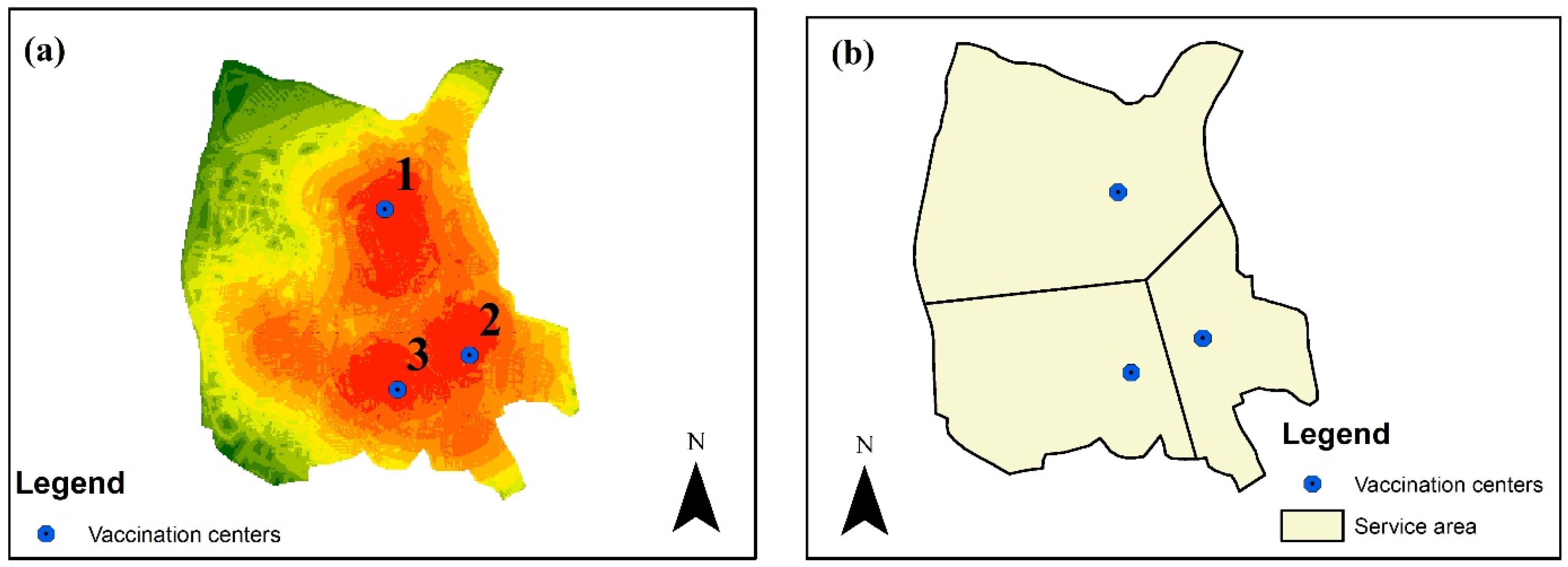
- The assignment of potential vaccination centres was made as three centres according to the suitability map. Service area analysis was carried out with Thiessen Polygon [23] in terms of the accessibility of assigned vaccination centres. The determination of service areas was included in this study for the first time in the literature, and the target group was directed to vaccination centres.
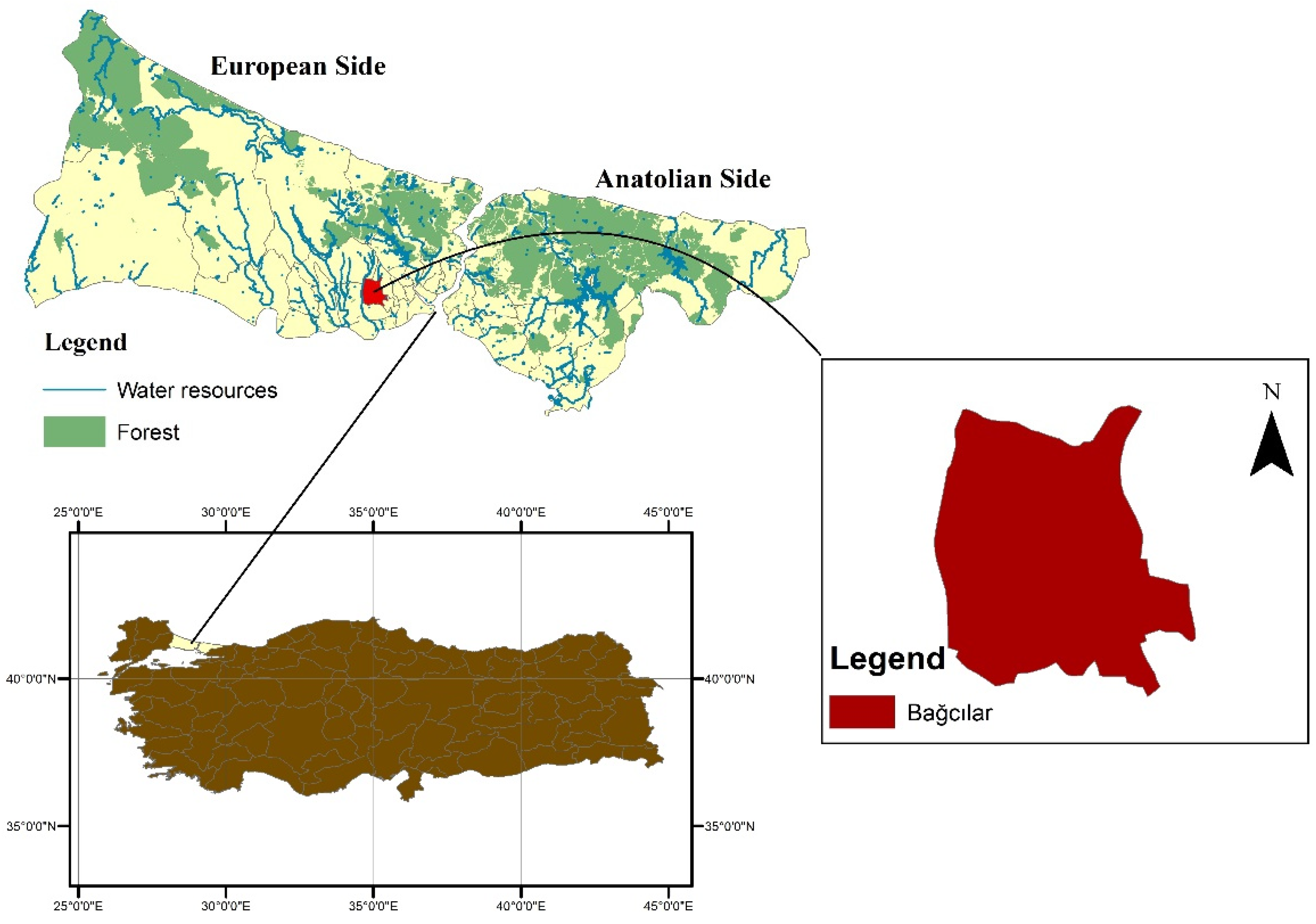
- Istanbul is most affected by the pandemic in Turkey, and this study was conducted in one of the districts of Istanbul with the highest population and number of daily cases. This district, where the risk on the health system is at a high level, was selected as the study area. In addition, this study, which is carried out under the worst-case scenario (high health system risk) conditions, can be easily applied in other study areas. Thanks to this situation, this study becomes a guide for the planned vaccination centres.
- The assigned vaccination centres can also be used as a testing centre for COVID-19 and possible outbreaks in the future, if needed.
- Especially, the location of vaccination centres is very important for the logistic and application of the vaccine in terms of authorised institutions and personnel, health workers, and target groups. The locations of vaccination centres were evaluated with a scientific framework and a guide is presented.
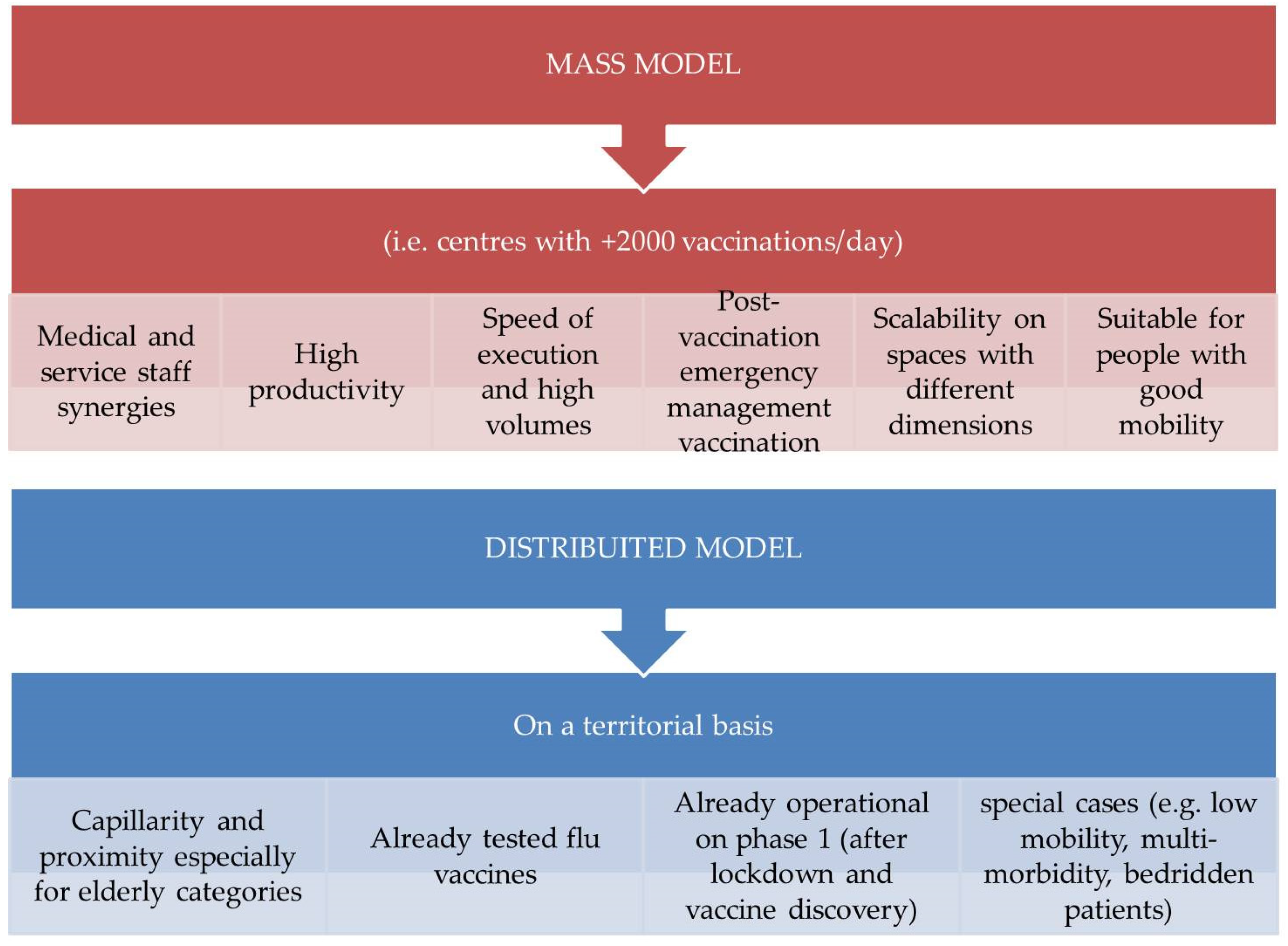
Impacts of COVID-19 on Mobility and Logistics
- Square metres
- Medical staff
- Health workers
- Administrative staff
- Number of vaccines/day administered
- Productivity (Vaccines/worker/day)
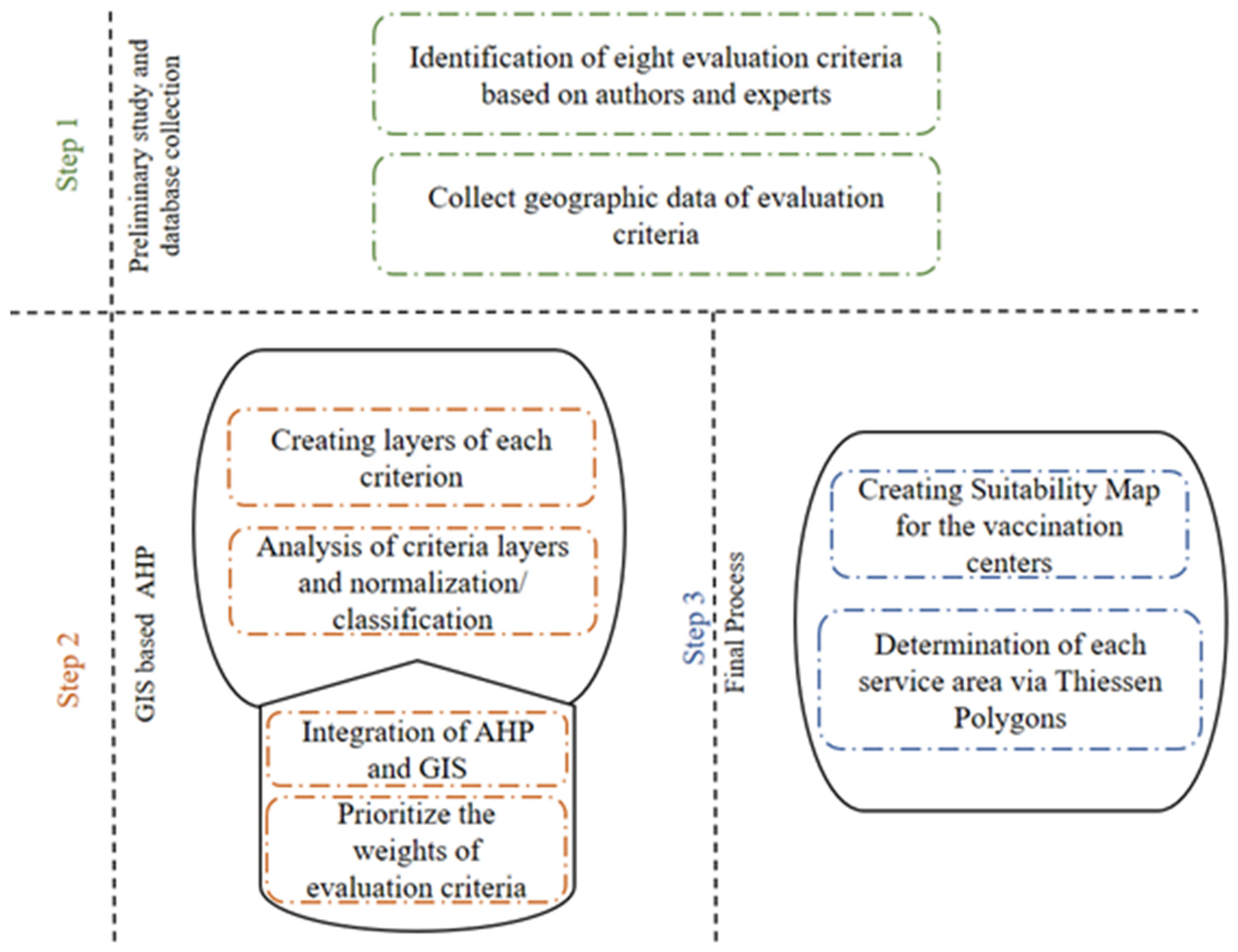
3. Materials
3.1. Study Area
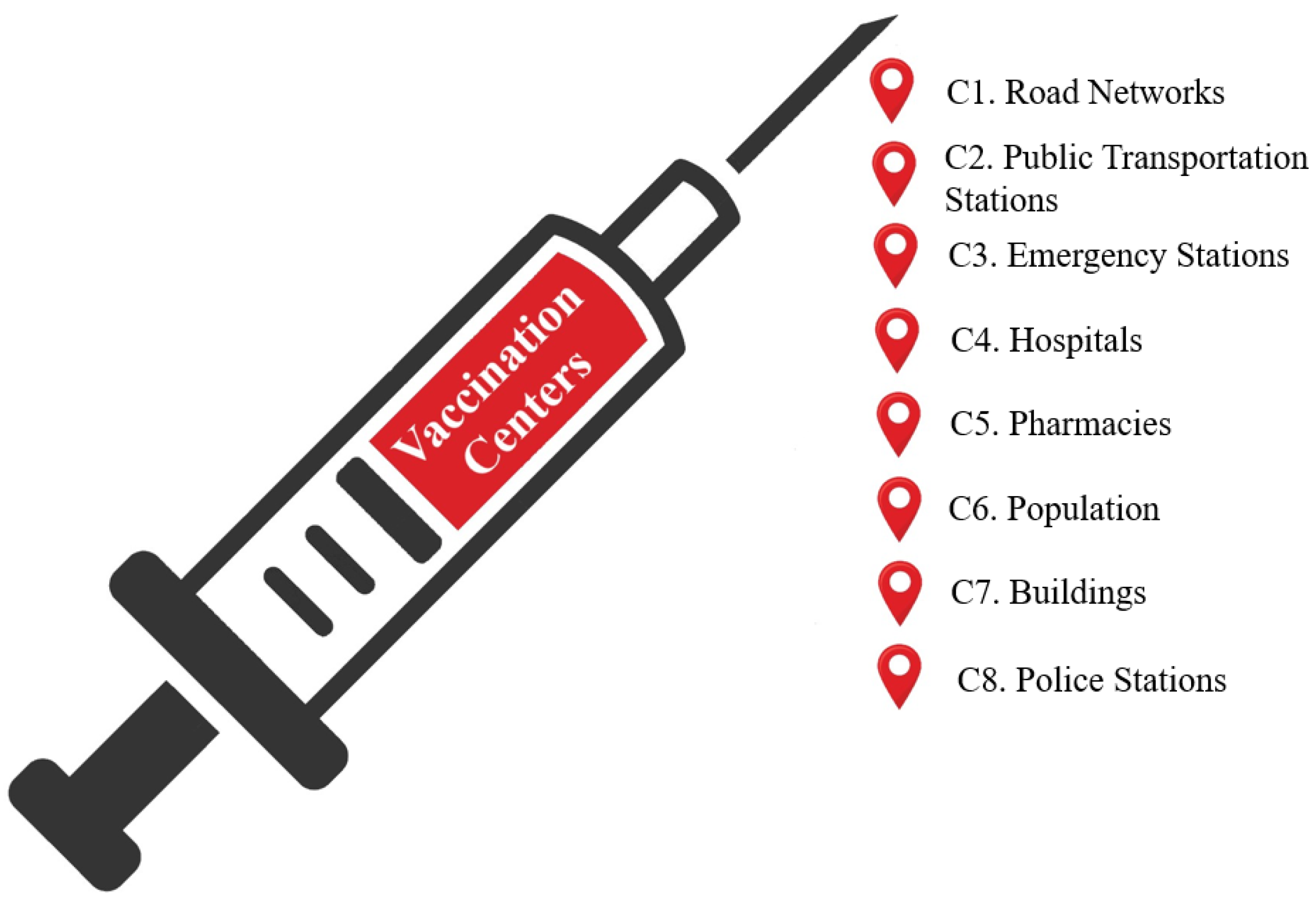
3.2. Defining the Evaluation Criteria
4. Methods
4.1. Analytic Hierarchy Process
4.2. Geographical Information Systems
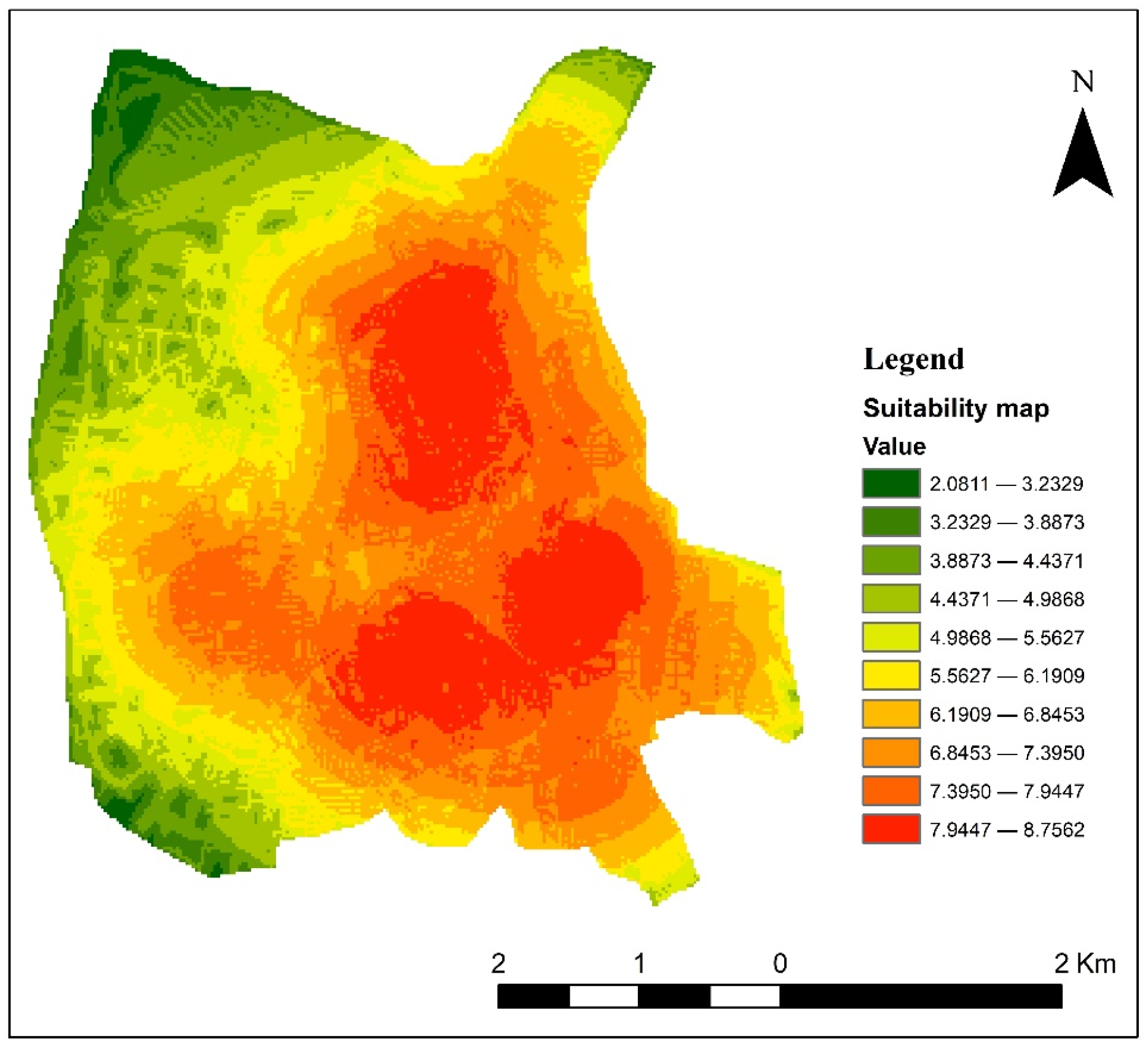
5. Results
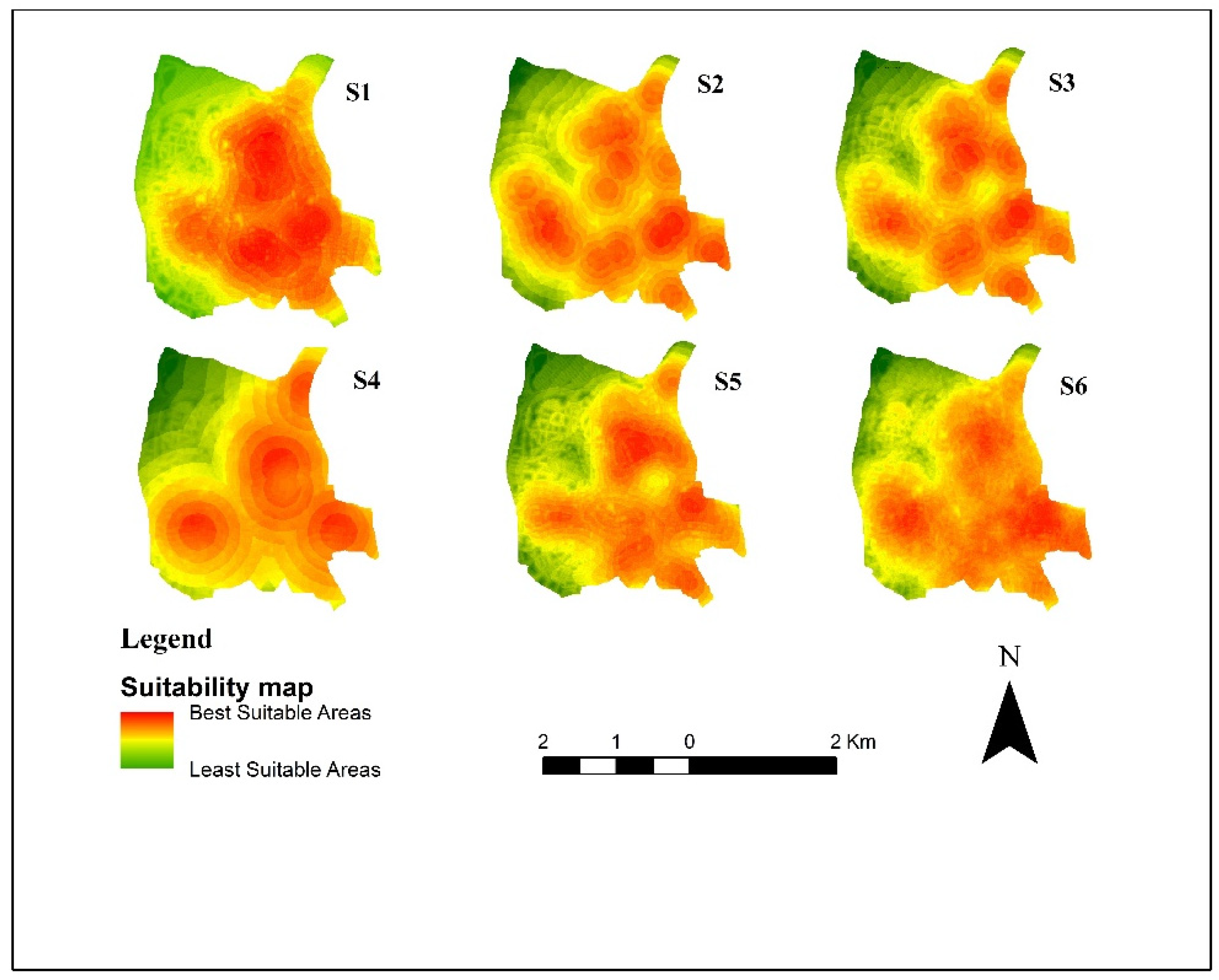
- Scenario 1 is current condition of criteria weights.
- Scenario 2, the weight of C1 and C2 criteria is decreased by 75%.
- Scenario 3, the weight of C3 and C4 criteria is decreased by 75%.
- Scenario 4, the weight of C5 and C6 criteria is decreased by 75%.
- Scenario 5, the weight of C7 and C8 criteria is decreased by 75%.
- Scenario 6, weights of all criteria are equal.
6. Discussion
7. Conclusions
Author Contributions
Funding
Institutional Review Board Statement
Informed Consent Statement
Data Availability Statement
Conflicts of Interest
References
- Gandhi, M.; Havlir, D. The time for universal masking of the public for coronavirus disease 2019 is now. Open Forum Infect. Dis. 2020, 7, 1–4. [Google Scholar] [CrossRef] [Green Version]
- Notari, A. Temperature dependence of COVID-19 transmission. Sci. Total Environ. 2021, 763, 144390. [Google Scholar] [CrossRef] [PubMed]
- Tiejun, Z. Implementation Status and Development Thinking on “Cloud National Examination” in China under the situation of “Online Anti-COVID-19 Epidemic”. Technol. Forecast. Soc. Chang. 2021, 162, 120322. [Google Scholar] [CrossRef] [PubMed]
- Fernández Cruz, M.; Álvarez Rodríguez, J.; Ávalos Ruiz, I.; Cuevas López, M.; de Barros Camargo, C.; Díaz Rosas, F.; González Castellón, E.; González González, D.; Hernández Fernández, A.; Ibáñez Cubillas, P.; et al. Evaluation of the Emotional and Cognitive Regulation of Young People in a Lockdown Situation Due to the COVID-19 Pandemic. Front. Psychol. 2020, 11, 565503. [Google Scholar] [CrossRef] [PubMed]
- Liu, Q.; Zhou, Y.; Xie, X.; Xue, Q.; Zhu, K.; Wan, Z.; Wu, H.; Zhang, J.; Song, R. The prevalence of behavioral problems among school-aged children in home quarantine during the COVID-19 pandemic in China. J. Affect. Disord. 2021, 279, 412–416. [Google Scholar] [CrossRef]
- Amit Aharon, A.; Dubovi, I.; Ruban, A. Differences in mental health and health-related quality of life between the Israeli and Italian population during a COVID-19 quarantine. Qual. Life Res. 2021, 30, 1675–1684. [Google Scholar] [CrossRef]
- Santana, F.N.; Hammond Wagner, C.; Berlin Rubin, N.; Bloomfield, L.S.P.; Bower, E.R.; Fischer, S.L.; Santos, B.S.; Smith, G.E.; Muraida, C.T.; Wong-Parodi, G. A path forward for qualitative research on sustainability in the COVID-19 pandemic. Sustain. Sci. 2021, 16, 1061–1067. [Google Scholar] [CrossRef]
- Epifanio, M.S.; Andrei, F.; Mancini, G.; Agostini, F.; Piombo, M.A.; Spicuzza, V.; Riolo, M.; Lavanco, G.; Trombini, E.; La Grutta, S. The Impact of COVID-19 Pandemic and Lockdown Measures on Quality of Life among Italian General Population. J. Clin. Med. 2021, 10, 289. [Google Scholar] [CrossRef]
- Zolfani, S.H.; Yazdani, M.; Torkayesh, A.E.; Derakhti, A. Application of a gray-based decision support framework for location selection of a temporary hospital during COVID-19 pandemic. Symmetry 2020, 12, 886. [Google Scholar] [CrossRef]
- Murgante, B.; Balletto, G.; Borruso, G.; Casas, G.L.; Castiglia, P.; Dettori, M. Geographical analyses of COVID-19’s spreading contagion in the challenge of global health risks. TeMA J. Land Use Mobil. Environ. 2020. [Google Scholar] [CrossRef]
- Dettori, M.; Deiana, G.; Balletto, G.; Borruso, G.; Murgante, B.; Arghittu, A.; Azara, A.; Castiglia, P. Air pollutants and risk of death due to COVID-19 in Italy. Environ. Res. 2021, 192, 110459. [Google Scholar] [CrossRef]
- Rawat, K.; Kumari, P.; Saha, L. COVID-19 vaccine: A recent update in pipeline vaccines, their design and development strategies. Eur. J. Pharmacol. 2021, 892, 173751. [Google Scholar] [CrossRef]
- Maqbool, A.; Khan, N.Z. Analyzing barriers for implementation of public health and social measures to prevent the transmission of COVID-19 disease using DEMATEL method. Diabetes Metab. Syndr. Clin. Res. Rev. 2020, 14, 887–892. [Google Scholar] [CrossRef] [PubMed]
- Li, D.D.; Li, Q.H. SARS-CoV-2: Vaccines in the pandemic era. Mil. Med Res. 2021, 8, 1–15. [Google Scholar] [CrossRef] [PubMed]
- Divu, D.N.; Mojjada, S.K.; Pokkathappada, A.A.; Sukhdhane, K.; Menon, M.; Mojjada, R.K.; Tade, M.S.; Bhint, H.M.; Gopalakrishnan, A. Decision-making framework for identifying best suitable mariculture sites along north east coast of Arabian Sea, India: A preliminary GIS-MCE based modelling approach. J. Clean. Prod. 2021, 284, 124760. [Google Scholar] [CrossRef]
- Ağaçsapan, B.; Çabuk, S.N. Determination of suitable waste transfer station areas for sustainable territories: Eskisehir case. Sustain. Cities Soc. 2020, 52, 101829. [Google Scholar] [CrossRef]
- Feyzi, S.; Khanmohammadi, M.; Abedinzadeh, N.; Aalipour, M. Multi- criteria decision analysis FANP based on GIS for siting municipal solid waste incineration power plant in the north of Iran. Sustain. Cities Soc. 2019, 47, 101513. [Google Scholar] [CrossRef]
- Bertram, D.V.; Tarighaleslami, A.H.; Walmsley, M.R.W.; Atkins, M.J.; Glasgow, G.D.E. A systematic approach for selecting suitable wave energy converters for potential wave energy farm sites. Renew. Sustain. Energy Rev. 2020, 132, 110011. [Google Scholar] [CrossRef]
- Lindberg, O.; Birging, A.; Widén, J.; Lingfors, D. PV park site selection for utility-scale solar guides combining GIS and power flow analysis: A case study on a Swedish municipality. Appl. Energy 2021, 282, 116086. [Google Scholar] [CrossRef]
- Afzali, A.; Sabri, S.; Rashid, M.; Mohammad Vali Samani, J.; Ludin, A.N.M. Inter-Municipal Landfill Site Selection Using Analytic Network Process. Water Resour. Manag. 2014, 28, 2179–2194. [Google Scholar] [CrossRef]
- Davtalab, M.; Alesheikh, A.A. Spatial optimization of biomass power plant site using fuzzy analytic network process. Clean Technol. Environ. Policy 2018, 20, 1033–1046. [Google Scholar] [CrossRef]
- Fahad, M.G.R.; Nazari, R.; Bhavsar, P.; Jalayer, M.; Karimi, M. A decision-support framework for emergency evacuation planning during extreme storm events. Transp. Res. Part D Transp. Environ. 2019, 77, 589–605. [Google Scholar] [CrossRef]
- Kaya, Ö.; Alemdar, K.D.; Çodur, M.Y. A novel two stage approach for electric taxis charging station site selection. Sustain. Cities Soc. 2020, 62, 102396. [Google Scholar] [CrossRef]
- Mrak, I.; Campisi, T.; Sanja, Š.; Errigo, M.F. MCDM evaluation in GIS system for evaluating the pedestrian and alternative paths in Rijeka. AIP Conf. Proc. 2021, 2343, 090004. [Google Scholar]
- Nyimbili, P.H.; Erden, T.; Karaman, H. Integration of GIS, AHP and TOPSIS for earthquake hazard analysis. Nat. Hazards 2018, 92, 1523–1546. [Google Scholar] [CrossRef]
- Trivedi, A.; Singh, A. A hybrid multi-objective decision model for emergency shelter location-relocation projects using fuzzy analytic hierarchy process and goal programming approach. Int. J. Proj. Manag. 2017, 35, 827–840. [Google Scholar] [CrossRef]
- Alemdar, K.D.; Kaya, Ö.; Canale, A.; Çodur, M.Y.; Campisi, T. Evaluation of Air Quality Index by Spatial Analysis Depending on Vehicle Traffic during the COVID-19 Outbreak in Turkey. Energies 2021, 14, 5729. [Google Scholar] [CrossRef]
- Balew, A.; Alemu, M.; Leul, Y.; Feye, T. Suitable landfill site selection using GIS-based multi-criteria decision analysis and evaluation in Robe town, Ethiopia. GeoJournal 2020. [Google Scholar] [CrossRef]
- Wang, J.; Tsai, C.H.; Lin, P.C. Applying spatial-temporal analysis and retail location theory to pubic bikes site selection in Taipei. Transp. Res. Part A Policy Pract. 2016, 94, 45–61. [Google Scholar] [CrossRef]
- Atici, K.B.; Simsek, A.B.; Ulucan, A.; Tosun, M.U. A GIS-based Multiple Criteria Decision Analysis approach for wind power plant site selection. Util. Policy 2015, 37, 86–96. [Google Scholar] [CrossRef]
- Uyan, M. Optimal site selection for solar power plants using multi-criteria evaluation: A case study from the Ayranci region in Karaman, Turkey. Clean Technol. Environ. Policy 2017, 19, 2231–2244. [Google Scholar] [CrossRef]
- Alemdar, K.D.; Kaya, Ö.; Çodur, M.Y. A GIS and microsimulation-based MCDA approach for evaluation of pedestrian crossings. Accid. Anal. Prev. 2020, 148, 105771. [Google Scholar] [CrossRef]
- Campisi, T.; Basbas, S.; Tesoriere, G.; Trouva, M.; Papas, T.; Mrak, I. How to Create Walking Friendly Cities. A Multi-Criteria Analysis of the Central Open Market Area of Rijeka. Sustainability 2020, 12, 9470. [Google Scholar] [CrossRef]
- Ortega, J.; Moslem, S.; Palaguachi, J.; Ortega, M.; Campisi, T.; Torrisi, V. An Integrated Multi Criteria Decision Making Model for Evaluating Park-and-Ride Facility Location Issue: A Case Study for Cuenca City in Ecuador. Sustainability 2021, 13, 7461. [Google Scholar] [CrossRef]
- Song, S.; Zhou, H.; Song, W. Sustainable shelter-site selection under uncertainty: A rough QUALIFLEX method. Comput. Ind. Eng. 2019, 128, 371–386. [Google Scholar] [CrossRef]
- Lin, C.T.; Tsai, M.C. Location choice for direct foreign investment in new hospitals in China by using ANP and TOPSIS. Qual. Quant. 2010, 44, 375–390. [Google Scholar] [CrossRef]
- Erbaş, M.; Kabak, M.; Özceylan, E.; Çetinkaya, C. Optimal siting of electric vehicle charging stations: A GIS-based fuzzy Multi-Criteria Decision Analysis. Energy 2018, 163, 1017–1031. [Google Scholar] [CrossRef]
- Kutlu Gündoǧdu, F.; Kahraman, C.; Civan, H.N. A novel hesitant fuzzy EDAS method and its application to hospital selection. J. Intell. Fuzzy Syst. 2018, 35, 6353–6365. [Google Scholar] [CrossRef]
- Senvar, O.; Otay, I.; Bolturk, E. Hospital Site Selection via Hesitant Fuzzy TOPSIS. IFAC-PapersOnLine 2016, 49, 1140–1145. [Google Scholar] [CrossRef]
- Aydin, N.Y.; Kentel, E.; Sebnem Duzgun, H. GIS-based site selection methodology for hybrid renewable energy systems: A case study from western Turkey. Energy Convers. Manag. 2013, 70, 90–106. [Google Scholar] [CrossRef]
- Mishra, A.K.; Deep, S.; Choudhary, A. Identification of suitable sites for organic farming using AHP & GIS. Egypt. J. Remote Sens. Space Sci. 2015, 18, 181–193. [Google Scholar] [CrossRef] [Green Version]
- Kaya, Ö.; Tortum, A.; Alemdar, K.D.; Çodur, M.Y. Site selection for EVCS in Istanbul by GIS and multi-criteria decision-making. Transp. Res. Part D Transp. Environ. 2020, 80, 102271. [Google Scholar] [CrossRef]
- Xu, J.; Zhong, L.; Yao, L.; Wu, Z. An interval type-2 fuzzy analysis towards electric vehicle charging station allocation from a sustainable perspective. Sustain. Cities Soc. 2018, 40, 335–351. [Google Scholar] [CrossRef]
- Tu, W.; Li, Q.; Fang, Z.; Shaw, S.L.; Zhou, B.; Chang, X. Optimizing the locations of electric taxi charging stations: A spatial–temporal demand coverage approach. Transp. Res. Part C Emerg. Technol. 2016, 65, 172–189. [Google Scholar] [CrossRef] [Green Version]
- Lin, M.; Huang, C.; Xu, Z. MULTIMOORA based MCDM model for site selection of car sharing station under picture fuzzy environment. Sustain. Cities Soc. 2020, 53, 101873. [Google Scholar] [CrossRef]
- Deveci, M.; Canıtez, F.; Gökaşar, I. WASPAS and TOPSIS based interval type-2 fuzzy MCDM method for a selection of a car sharing station. Sustain. Cities Soc. 2018, 41, 777–791. [Google Scholar] [CrossRef]
- Özceylan, E.; Çetinkaya, C.; Erbaş, M.; Kabak, M. Logistic performance evaluation of provinces in Turkey: A GIS-based multi-criteria decision analysis. Transp. Res. Part A Policy Pract. 2016, 94, 323–337. [Google Scholar] [CrossRef]
- Kabak, M.; Erbaş, M.; Çetinkaya, C.; Özceylan, E. A GIS-based MCDM approach for the evaluation of bike-share stations. J. Clean. Prod. 2018, 201, 49–60. [Google Scholar] [CrossRef]
- Williams, L.; Flowers, P.; McLeod, J.; Young, D.; Rollins, L. Social patterning and stability of COVID-19 vaccination acceptance in Scotland: Will those most at risk accept a vaccine? medRxiv 2020. [Google Scholar] [CrossRef]
- Bhaduri, E.; Manoj, B.S.; Wadud, Z.; Goswami, A.K.; Choudhury, C.F. Modelling the effects of COVID-19 on travel mode choice behaviour in India. Transp. Res. Interdiscip. Perspect. 2020, 8, 100273. [Google Scholar] [CrossRef]
- Irawan, M.Z.; Belgiawan, P.F.; Joewono, T.B.; Bastarianto, F.F.; Rizki, M.; Ilahi, A. Exploring activity-travel behavior changes during the beginning of COVID-19 pandemic in Indonesia. Transportation 2021. [Google Scholar] [CrossRef]
- Astroza, S.; Tirachini, A.; Hurtubia, R.; Carrasco, J.A.; Guevara, A.; Munizaga, M.; Figueroa, M.; Torres, V. Mobility Changes, Teleworking, and Remote Communication during the COVID-19 Pandemic in Chile. Findings 2020, 1, 1–8. [Google Scholar] [CrossRef]
- Belzunegui-Eraso, A.; Erro-Garcés, A. Teleworking in the Context of the COVID-19 Crisis. Sustainability 2020, 12, 3662. [Google Scholar] [CrossRef]
- Hahn, J. Has Turkey Lost Control of the Coronavirus Pandemic? Available online: https://p.dw.com/p/3mlvD (accessed on 10 February 2021).
- Kitano, T.; Aoki, H. A model for the incremental burden of invasive Haemophilus influenzae type b due to a decline of childhood vaccination during the COVID-19 outbreak: A dynamic transmission model in Japan. Vaccine 2021, 39, 343–349. [Google Scholar] [CrossRef] [PubMed]
- Turkish Statistical Institute Number of Vehicles 2019. Available online: http://www.tuik.gov.tr/PreIstatistikTablo.do?istab_id=362 (accessed on 12 February 2021).
- Republic of the Turkey Ministry COVID-19 Information Page. Available online: https://covid19.saglik.gov.tr/?_Dil=2 (accessed on 10 February 2021).
- Turkish Statistical Institute (TSI) Population by Province, Single Age and Sex. Available online: https://data.tuik.gov.tr/Bulten/DownloadIstatistikselTablo?p=8nHwYVFJKFLIkqNS6KXjzqUmg0kXoZyHDjG5Z2WaRW/jFhEZf4GgiLHIt6jidK9C (accessed on 16 January 2021).
- Reuters COVID-19 Tracker: Turkey. Available online: https://graphics.reuters.com/world-coronavirus-tracker-and-maps/countries-and-territories/turkey/. (accessed on 11 February 2021).
- Turkish Statistical Institute (TSI) Health Statistics. Available online: http://www.turkstat.gov.tr/PreIstatistikTablo.do?istab_id=2926 (accessed on 21 April 2020).
- Turkish Statistical Institute (TSI) Population and Demography. Available online: http://www.turkstat.gov.tr/PreTablo.do?alt_id=1047 (accessed on 21 April 2020).
- Republic of Turkey Ministry of Health COVID-19. Available online: https://covid19.saglik.gov.tr/ (accessed on 21 April 2020).
- Saaty, T.L. A scaling method for priorities in hierarchical structures. J. Math. Psychol. 1977, 15, 234–281. [Google Scholar] [CrossRef]
- Saaty, T.L.; Ozdemir, M.S. Why the magic number seven plus or minus two. Math. Comput. Model. 2003, 38, 233–244. [Google Scholar] [CrossRef]
- Castro-Santos, L.; Lamas-Galdo, M.I.; Filgueira-Vizoso, A. Managing the oceans: Site selection of a floating offshore wind farm based on GIS spatial analysis. Mar. Policy 2020, 113, 103803. [Google Scholar] [CrossRef]
- Winter, S. Bridging vector and raster representation in GIS. In Proceedings of the 6th ACM International Symposium on Advances in Geographic Information Systems, Washington, DC, USA, 2–7 November 1998; pp. 57–62. [Google Scholar]
- Chan, T.O.; Williamson, I.P. The different identities of GIS and GIS diffusion. Int. J. Geogr. Inf. Sci. 1999, 13, 267–281. [Google Scholar] [CrossRef]
- Singh, L.K.; Jha, M.K.; Chowdary, V.M. Multi-criteria analysis and GIS modeling for identifying prospective water harvesting and artificial recharge sites for sustainable water supply. J. Clean. Prod. 2017, 142, 1436–1456. [Google Scholar] [CrossRef]
- Wang, C.H.; Chen, N. A GIS-based spatial statistical approach to modeling job accessibility by transportation mode: Case study of Columbus, Ohio. J. Transp. Geogr. 2015, 45, 1–11. [Google Scholar] [CrossRef]
- Cronan, K.M. Coronavirus (COVID-19): Getting Tested at a Drive-Thru Testing Site. Available online: https://kidshealth.org/en/parents/coronavirus-drive-thru-tests.html (accessed on 22 September 2020).
- Kumar, P.; Singh, R.K.; Sinha, P. Optimal site selection for a hospital using a fuzzy extended ELECTRE approach. J. Manag. Anal. 2016, 3, 115–135. [Google Scholar] [CrossRef]


| Study Topics of the Site Selection | Methodologies | References |
|---|---|---|
| Hospital | TOPSIS-ANP, Hesitant Fuzzy TOPSIS | [36,39] |
| Hospital for organ transplantation | Hesitant Fuzzy EDAS | [38] |
| Renewable energy systems | A fuzzy set theory and GIS | [40] |
| Organic farming | AHP and GIS | [41] |
| Electric vehicle charging station | GIS-AHP-TOPSIS, GIS-AHP-PROMETHEE-VIKOR, Entropy-ELECTRE, Genetic Algorithm | [37,42,43,44] |
| Car sharing | MULTIMOORA, WASPAS-TOPSIS | [45,46] |
| Logistic centers | AHP-ANP-TOPSIS-GIS, DEA-R_FUCON-R_CoCoSo | [9,47] |
| Wind and Solar Farm | ELECTRE-GIS, AHP-GIS, AHP-GIS | [30,31,48] |
| Bike sharing stations | AHP-MOORA-GIS | [48] |
| Pedestrian Crossing | AHP-VIKOR-VISSIM-GIS | [32] |
| Criterion | Explanation | Data Source | Type of Analysis |
|---|---|---|---|
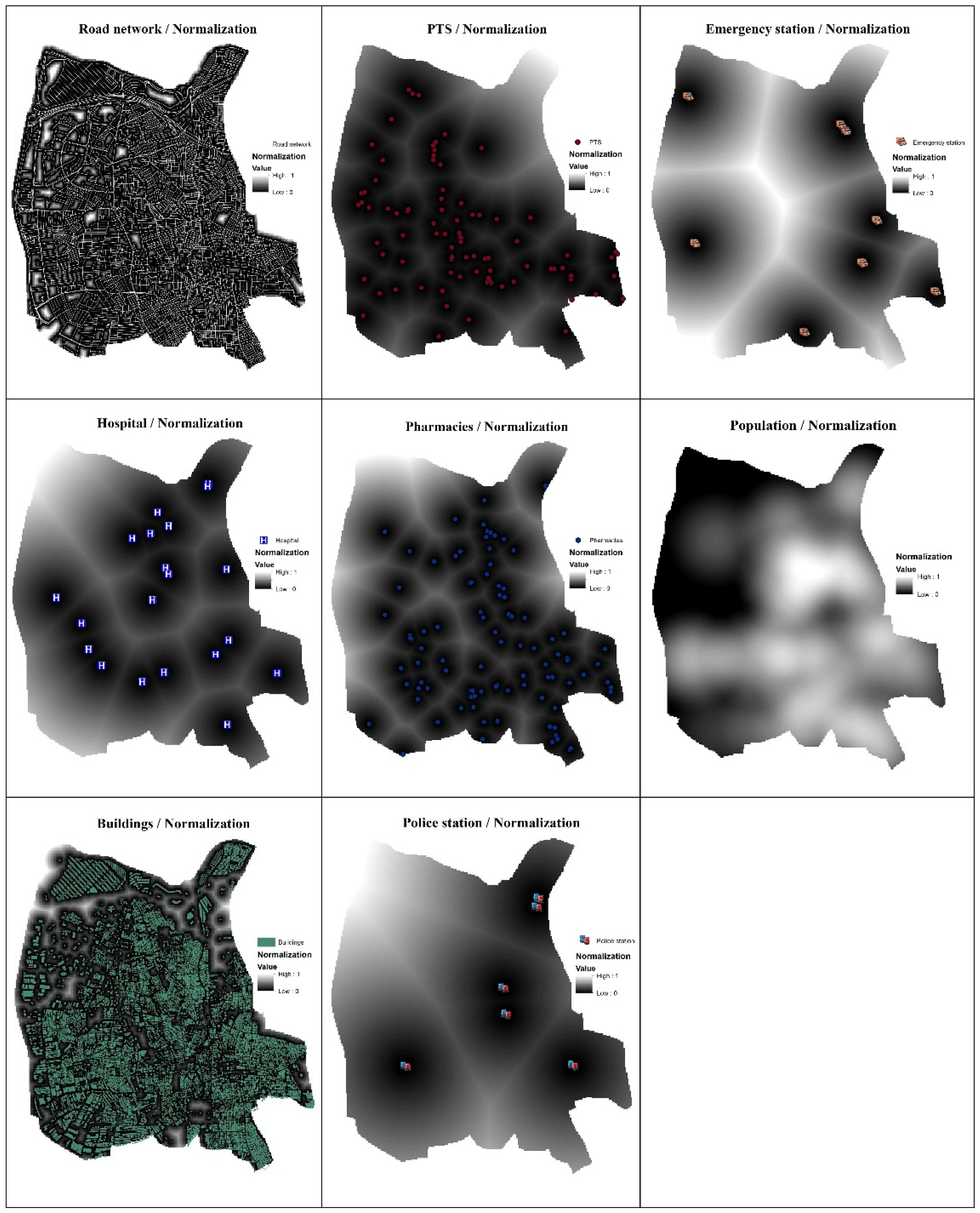
| Road networks | Considering all road networks of the district, vaccination centers should be designed to serve the entire district in terms of transportation. For this reason, it is thought that vaccination centers close to road networks will be more efficient. | https://uym.ibb.gov.tr/YHarita/Harita_tr.aspx (Accessed Date: 5 April 2021) | Euclidean Distance |
| PTS | Since vehicle mobility is high at PTS points, it will be appropriate to perform vaccination in these regions. Therefore, proximity to these regions is important in analysis. The district has 110. Since it is thought that not everyone has a private vehicle, individuals who want to be vaccinated should be able to reach vaccination centers by public transport. | https://www.iett.istanbul/tr/main/hatlar/ (Accessed Date: 6 April 2021) | Euclidean Distance |
| Emergency stations | In case of an emergency in the vaccination centers, its proximity to these regions is important in order to intervene fast. The district has nine. Considering that there are still suspicions for the side effects of vaccines and studies are ongoing, proximity to emergency stations is important for patient health in case of an unexpected side effect. | https://bagcilar.istanbulsaglik.gov.tr/hakkinda/sayisalbilgiler (Accessed Date: 7 April 2021) | Euclidean Distance |
| Hospitals | In case of a phenomenal situation (side effect) in vaccination centers, infected people should be transferred to hospitals and the proximity of these centers to hospitals is important for analysis. The district has 20. | https://bagcilar.istanbulsaglik.gov.tr/hakkinda/hastaneler (Accessed Date: 10 April 2021) | Euclidean Distance |
| Pharmacies | Proximity to pharmacies is important to meet the medical material needs that may occur in vaccination centers. The district has 99. | https://www.eczaneler.gen.tr/eczaneler/istanbul-bagcilar (Accessed Date: 11 April 2021) | Euclidean Distance |
| Population | It is very important to establishment vaccination centers in these regions, as the mobility and contact are high in dense populations. In addition, vaccination centers will play an important role in meeting the demand for vaccines in densely populated areas. | http://www.tuik.gov.tr/PreIstatistikTablo.do?istab_id=220 (Accessed Date: 7 April 2021) | Kernel Density |
| Buildings | Since the mobility between the settlement areas is high, the siting of vaccination centers in these areas is very important for case diagnosis and thus the efficiency of these centers will be increased. | https://sehirharitasi.ibb.gov.tr/ (Accessed Date: 5 May 2021) | Euclidean Distance |
| Police stations | Proximity of the police stations against any security problems (the desire of infected people to escape, discussion, fighting etc.) that may occur in vaccination centers is important for the intervention. The district has six. | https://www.egm.gov.tr/en-yakin-polis-merkezi (Accessed Date: 7 April 2021) | Euclidean Distance |
| n | 1 | 2 | 3 | 4 | 5 | 6 | 7 | 8 | 9 | 10 |
|---|---|---|---|---|---|---|---|---|---|---|
| RI | 0 | 0 | 0.52 | 0.89 | 1.11 | 1.25 | 1.35 | 1.40 | 1.45 | 1.49 |
| Criterion | Road Networks | PTS | Emergency Stations | Hospitals | Pharmacies | Population | Buildings | Police Station |
|---|---|---|---|---|---|---|---|---|
| Weights | 0.2123 | 0.0488 | 0.0714 | 0.2123 | 0.0236 | 0.3501 | 0.0555 | 0.0261 |
Publisher’s Note: MDPI stays neutral with regard to jurisdictional claims in published maps and institutional affiliations. |
© 2021 by the authors. Licensee MDPI, Basel, Switzerland. This article is an open access article distributed under the terms and conditions of the Creative Commons Attribution (CC BY) license (https://creativecommons.org/licenses/by/4.0/).
Share and Cite
Alemdar, K.D.; Kaya, Ö.; Çodur, M.Y.; Campisi, T.; Tesoriere, G. Accessibility of Vaccination Centers in COVID-19 Outbreak Control: A GIS-Based Multi-Criteria Decision Making Approach. ISPRS Int. J. Geo-Inf. 2021, 10, 708. https://doi.org/10.3390/ijgi10100708
Alemdar KD, Kaya Ö, Çodur MY, Campisi T, Tesoriere G. Accessibility of Vaccination Centers in COVID-19 Outbreak Control: A GIS-Based Multi-Criteria Decision Making Approach. ISPRS International Journal of Geo-Information. 2021; 10(10):708. https://doi.org/10.3390/ijgi10100708
Chicago/Turabian StyleAlemdar, Kadir Diler, Ömer Kaya, Muhammed Yasin Çodur, Tiziana Campisi, and Giovanni Tesoriere. 2021. "Accessibility of Vaccination Centers in COVID-19 Outbreak Control: A GIS-Based Multi-Criteria Decision Making Approach" ISPRS International Journal of Geo-Information 10, no. 10: 708. https://doi.org/10.3390/ijgi10100708