
History and Archaeology in Discourse on the Dernberg–Reconstructing the Historical Landscape of a Medieval Motte-and-Bailey Castle and Deserted Village

 ,
,  , ,
, ,  , and
, and 
Abstract
:1. Introduction
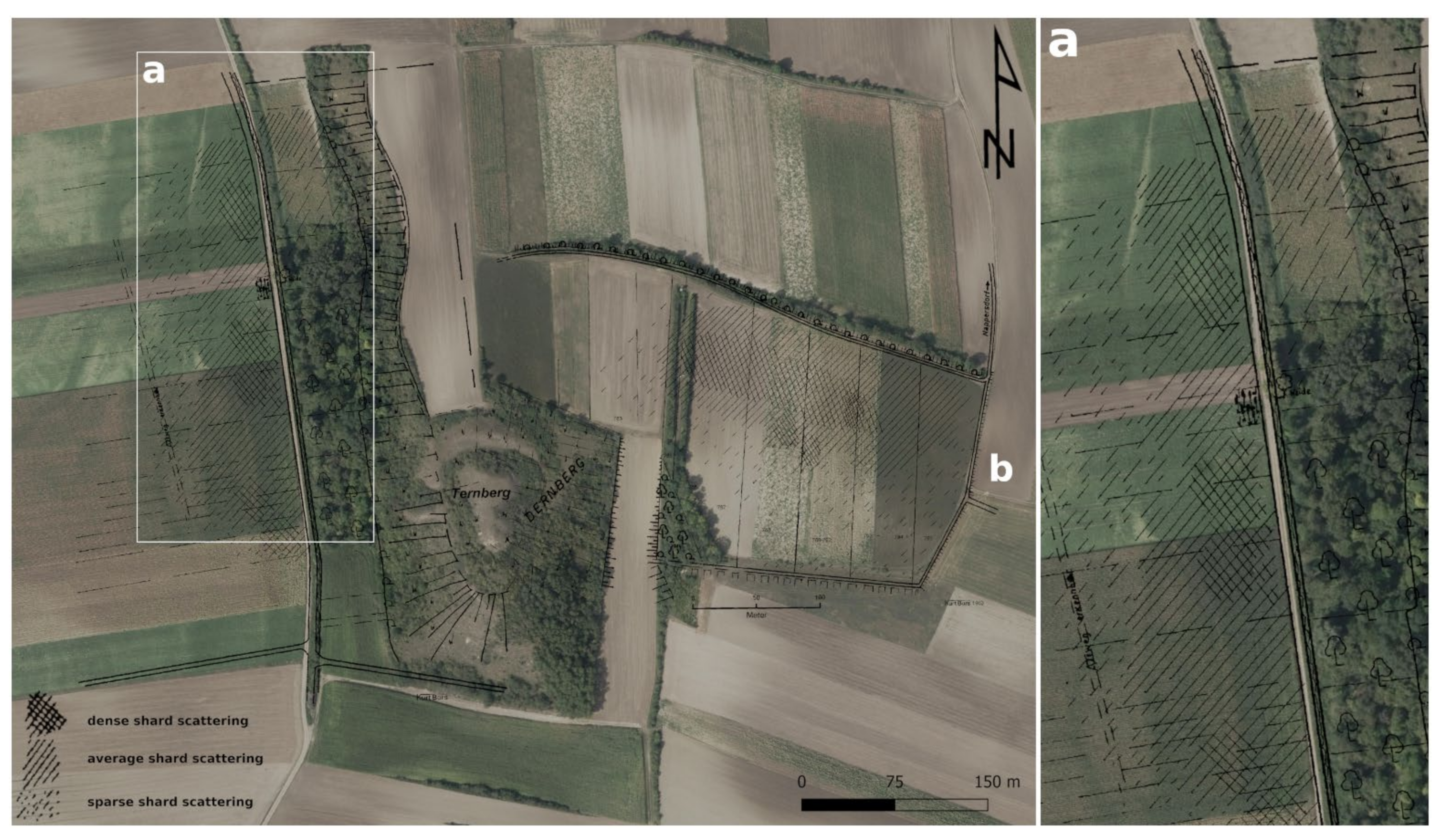
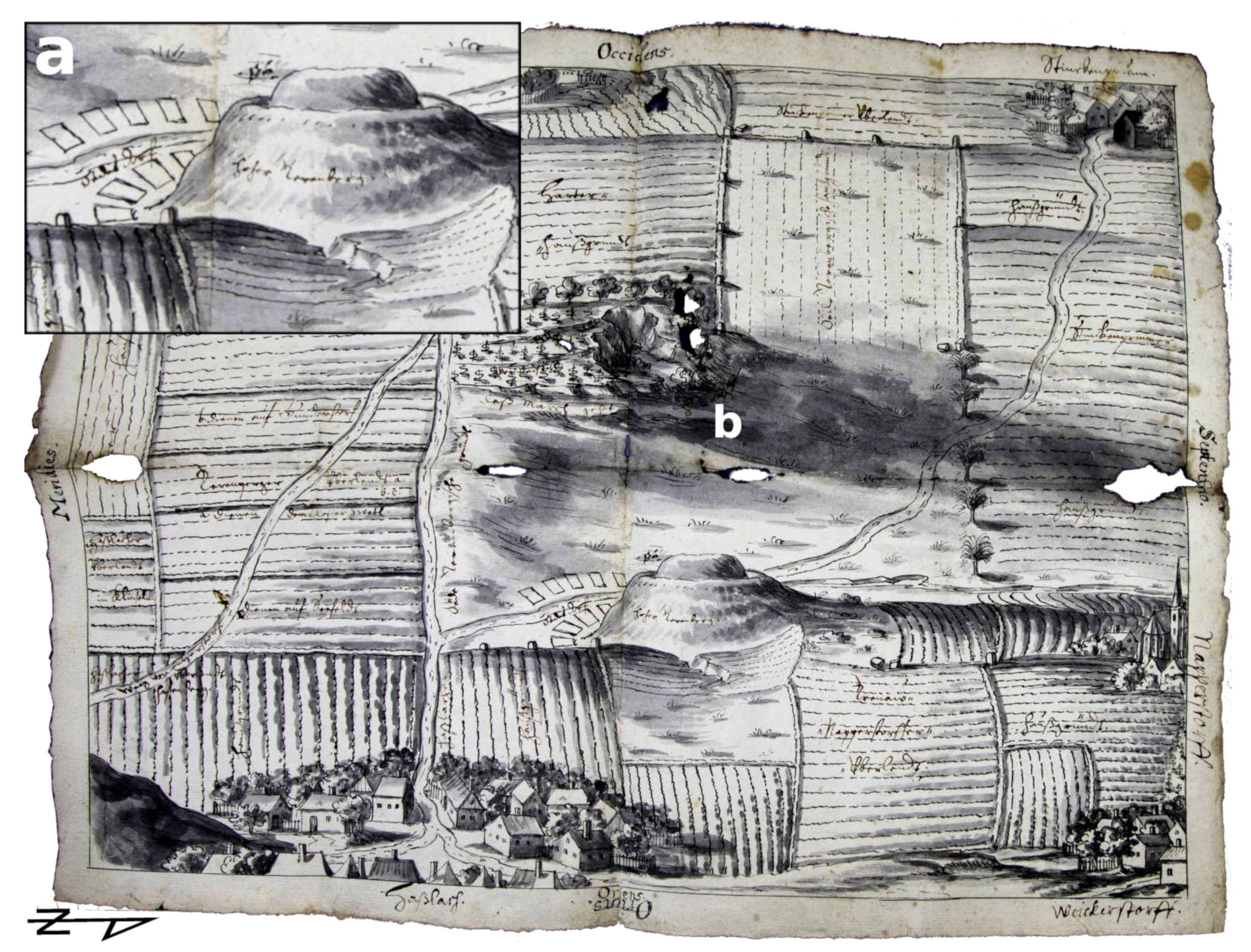
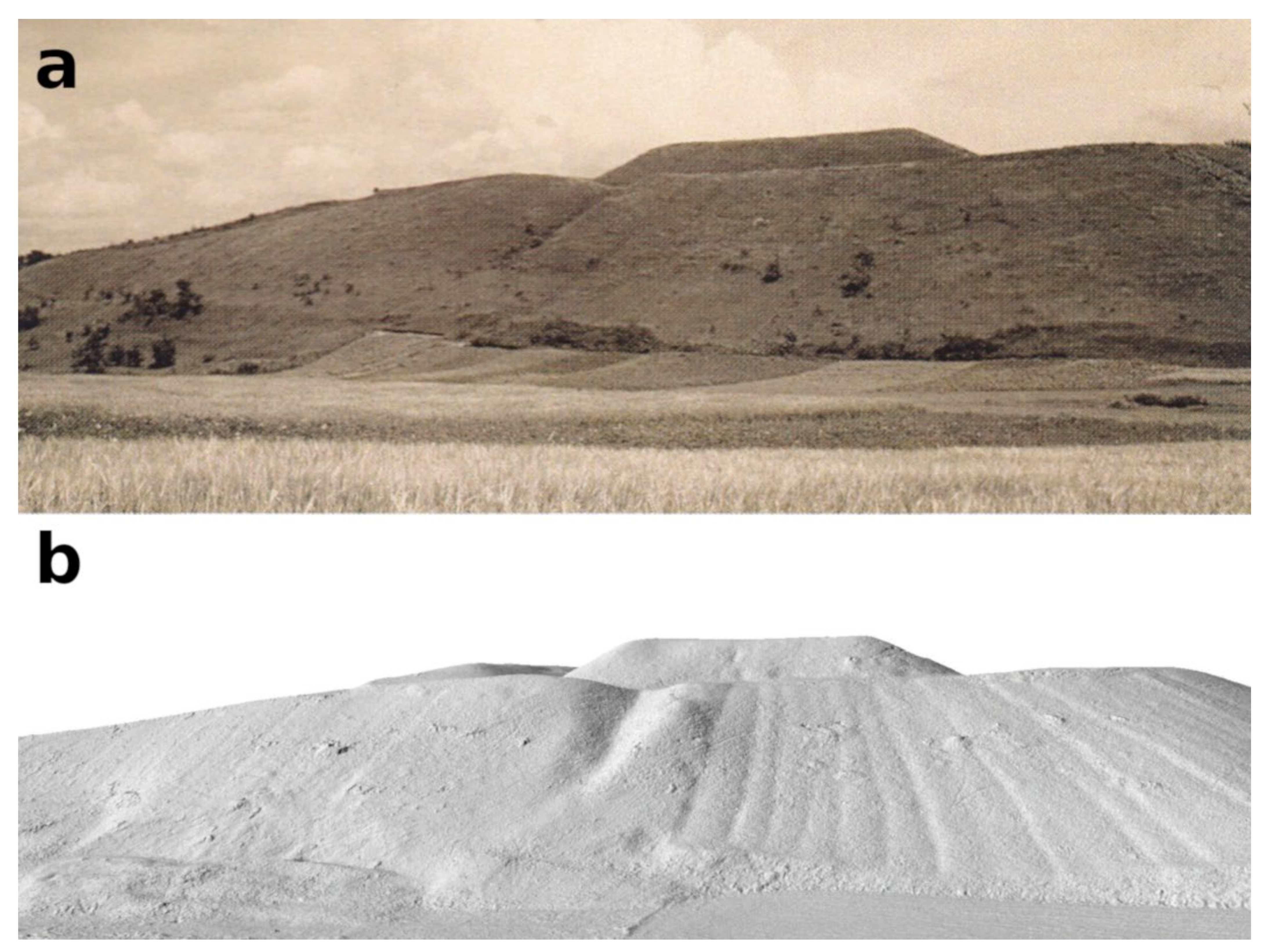
The Dernberg
2. Materials and Methods
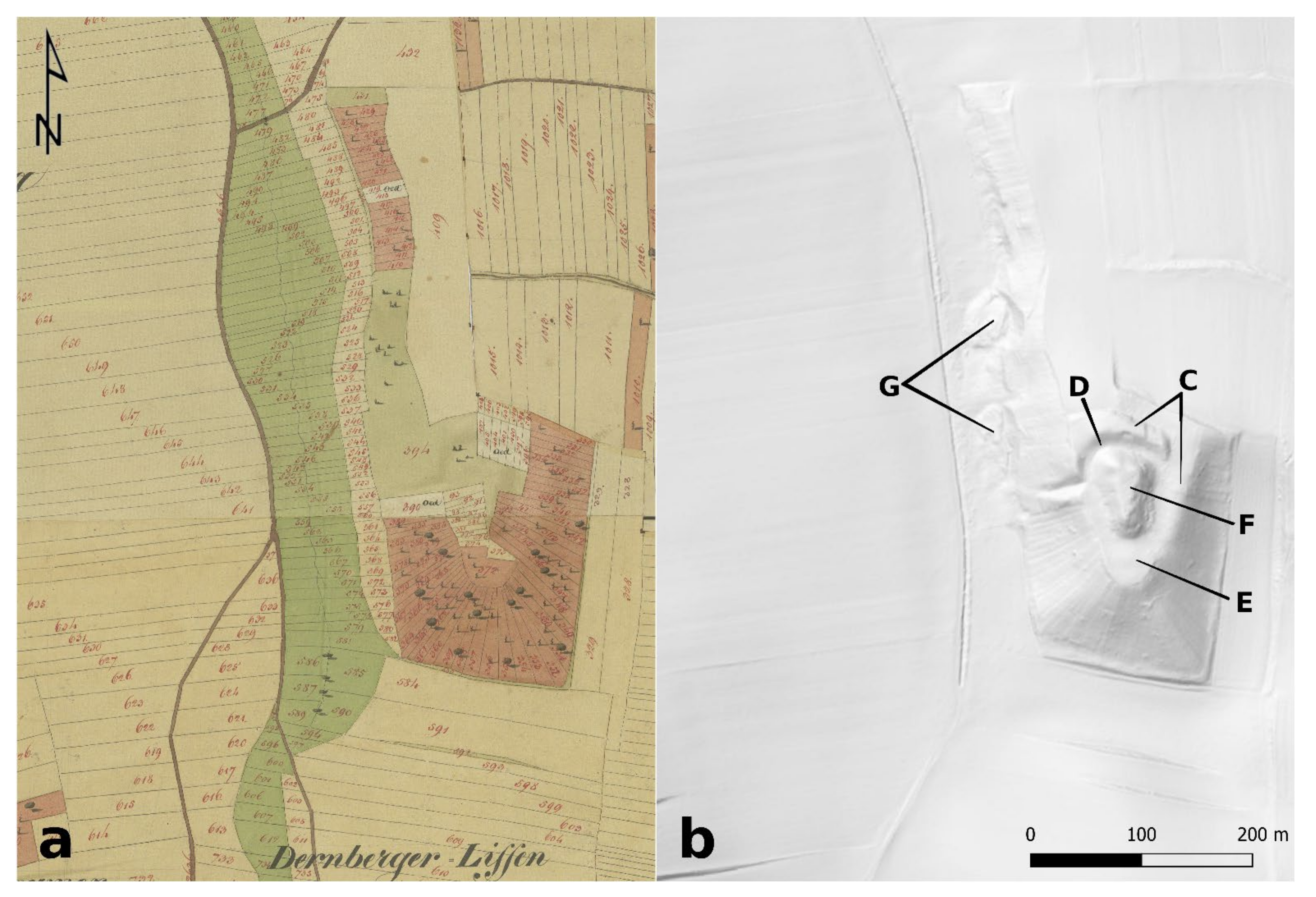
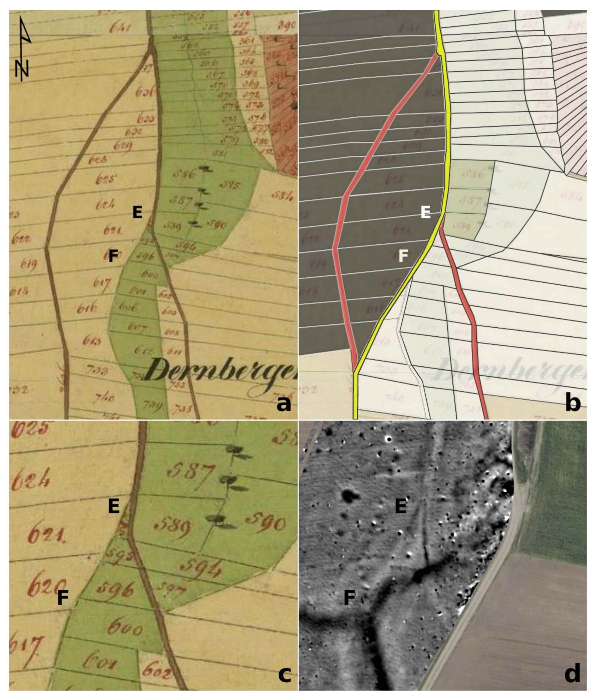
2.1. Historical Sources
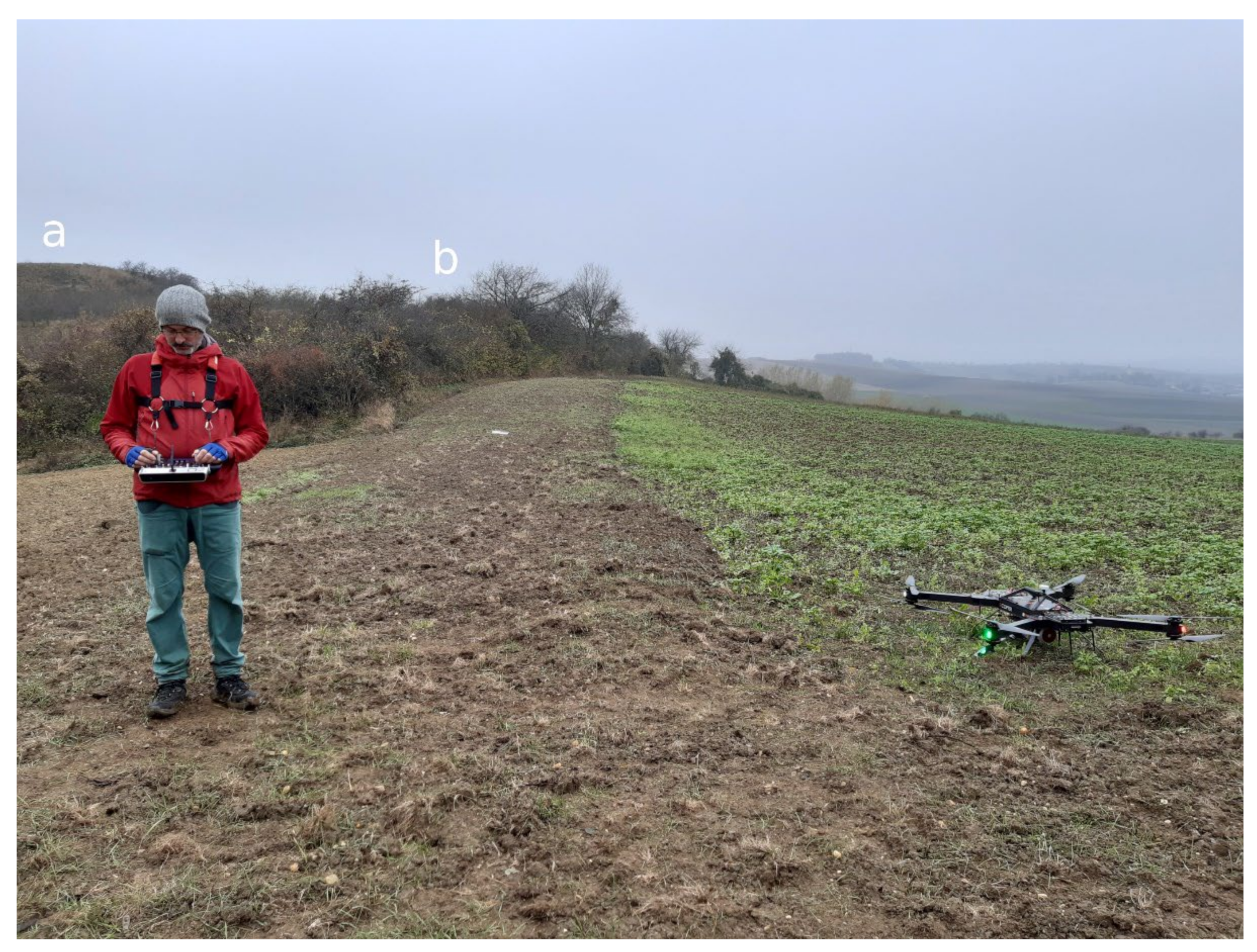
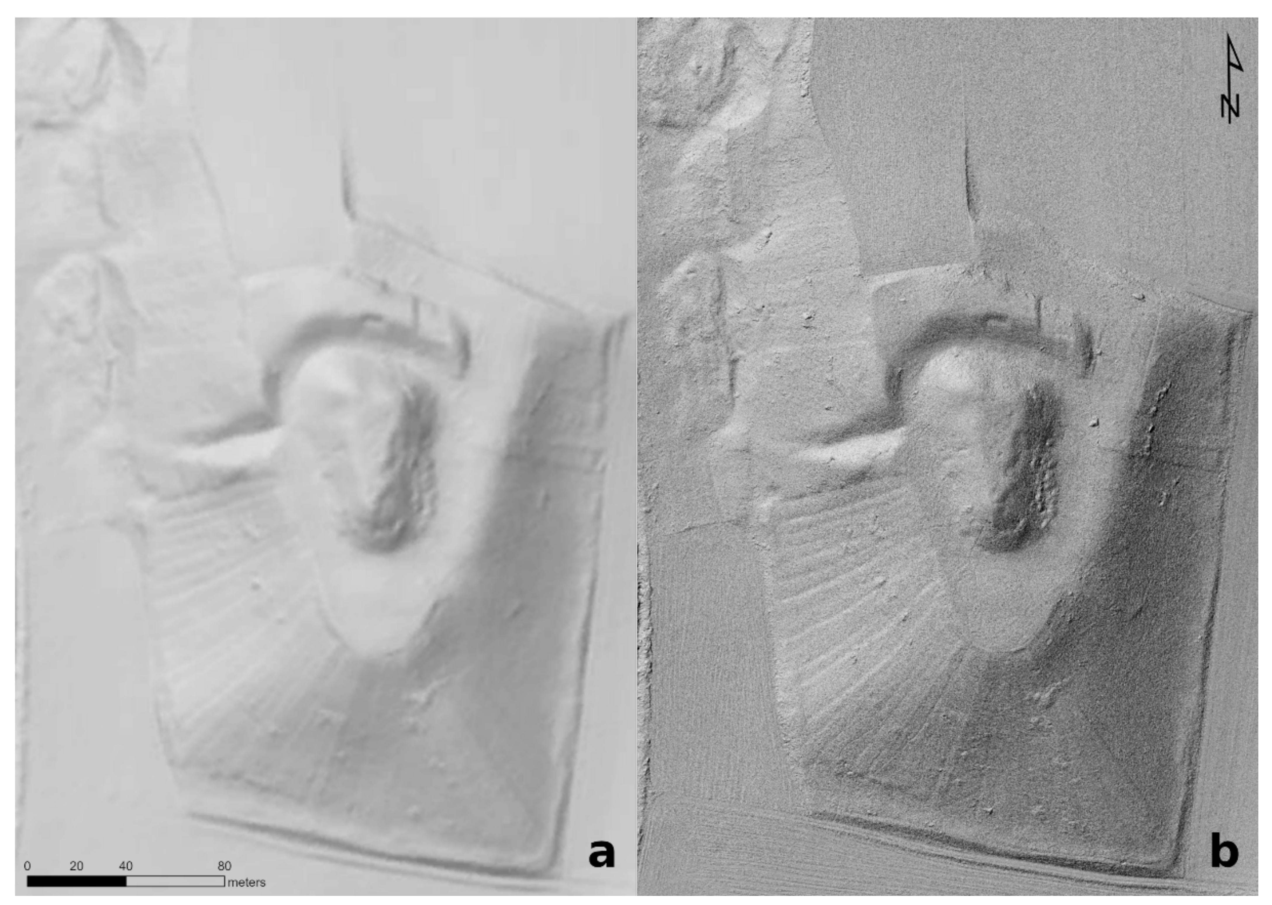
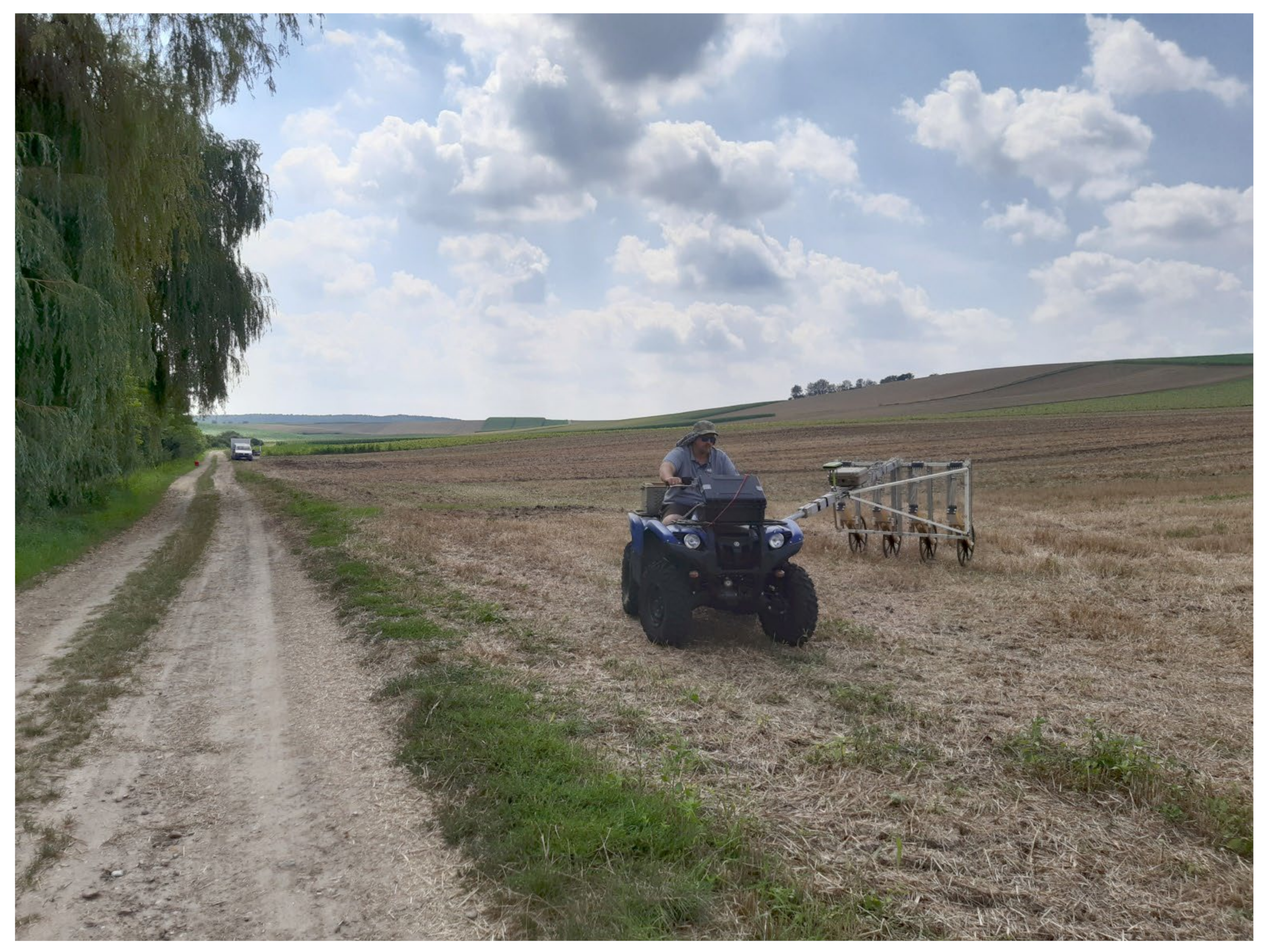
2.2. Archaeological Sources
3. Results
4. Discussion
5. Conclusions
Author Contributions
Funding
Institutional Review Board Statement
Informed Consent Statement
Data Availability Statement
Acknowledgments
Conflicts of Interest
| 1 | Data according to https://bodenkarte.at (accessed on 24 March 2021). |
| 2 | See http://noeburgen.imareal.sbg.ac.at/result/burgid/651; http://www.univie.ac.at/wuestungsforschung/archiv.htm (accessed on 26 April 2022). |
References
- Bors, K. Methodische Erfahrungen in der Ortswüstungsforschung. Beiträge zur Mittelalterarchäologie in Österreich—Beiheft 7; Österreichische Gesellschaft für Mittelalterarchäologie: Wien, Austria, 2007. [Google Scholar]
- Hofstätter, E. Beiträge zur Geschichte der Österreichischen Landesaufnahmen—Ein Überblick der Topographischen Aufnahmeverfahren, deren Ursprünge, Ihrer Entwicklungen und Organisationsformen der vier Österreichischen Landesaufnahmen. Teil 1; Bundesamt für Eich- und Vermessungswesen: Wien, Austria, 1989; Volume 1. [Google Scholar]
- Rill, R. Die Anfänge der Militärkartographie in den habsburgischen Erblanden: Die Josephinische Landesaufnahme von Böhmen und Mähren nach hofkriegsrätlichen Quellen. Mitteilungen des Österreichischen Staatsarchivs 2001, 49, 183–202. [Google Scholar]
- Scharrer-Liška, G. Überblick zu modernen und naturwissenschaftlichen Prospektionsmethoden in der Wüstungs- und Ortswüstungsforschung. Beiträge zur Mittelalterarchäologie Österreich 2001, 7, 63–78. [Google Scholar]
- Filzwieser, R.; Eichert, S. Towards an Online Database for Archaeological Landscapes. Using the Web Based, Open Source Software OpenAtlas for the Acquisition, Analysis and Dissemination of Archaeological and Historical Data on a Landscape Basis. Heritage 2020, 3, 1385–1401. [Google Scholar] [CrossRef]
- Neubauer, W. Magnetische Prospektion in der Archäologie; Verlag der Österreichischen Akademie der Wissenschaften: Wien, Austria, 2001. [Google Scholar]
- Filzwieser, R.; Aldrian, L.; Stadler, H.; Neubauer, W. Burg Schönwerth—Archäologische Re-Prospektion einer wüsten mittelalterlichen Niederungsburg in Volders, Tirol. Archaeol. Austriaca 2021, 105, 205–222. [Google Scholar] [CrossRef]
- Kühtreiber, K. Zu den mittelalterlichen Wüstungen im Leitharaum. In Die Leitha—Facetten einer Landschaft; Doneus, M., Griebl, M., Eds.; Österreichische Gesellschaft für Ur- und Frühgeschichte und AutorInnen: Wien, Austria, 2015; pp. 233–247. [Google Scholar]
- Andrén, A. Between Artifacts and Texts—Historical Archaeology in Global Perspective; Plenum Press: New York, NY, USA, 1998. [Google Scholar]
- Schad‘n, H.P. Die Hausberge und Verwandten Wehranlagen in Niederösterreich. Ein Beitrag zur Geschichte des Befestigungswesens und seiner Entwicklung vom Ringwall bis zur Mauerburg und Stadtumwehrung. Prähistorische Forschungen 1953, 3. [Google Scholar]
- Schad´n, H.P. Die Hausberge und verwandten Wehranlagen in Niederösterreich. Ein Beitrag zur Geschichte des mittelalterlichen Befestigungswesens und seiner Entwicklung vom Ringwall bis zur Mauerburg und Stadtumwehrung. Mitteilungen der Anthropol. Gesellschaft Wien 1950, 80, 245–352. [Google Scholar]
- Schad´n, H.P. Die Hausberge und verwandten Wehranlagen in Niederösterreich. Ein Beitrag zur Geschichte des mittelalterlichen Befestigungswesens und seiner Entwicklung vom Ringwall bis zur Mauerburg und Stadtumwehrung. Mitteilungen der Anthropol. Gesellschaft Wien 1953, 81, 25–185. [Google Scholar]
- Bors, K. Wüstungsforschung um das ‘Lange Thal’ bei Hollabrunn. Unsere Heim. 1988, 59, 328–355. [Google Scholar]
- Hasenhündl, G. Der Wilde Osten vor 1000 Jahren. Von Hausbergen und ‘Versunkenen’ Dörfern; Hollabrunner Museumsverein: Hollabrunn, Austria, 2018. [Google Scholar]
- Reichhalter, G.; Kühtreiber, K.; Kühtreiber, T. Burgen Weinviertel; Freytag & Berndt: Wien, Austria, 2005. [Google Scholar]
- Fittner, W.J. Abgekommene Orte um das ‘Lange Thal’ bei Hollabrunn. Jahrb. Landeskd. Niederosterr. 2019, 85, 77–91. [Google Scholar]
- Kupfer, E. Das Weinviertel. Herrschaft, Siedlung und Soziales Geflecht im Hohen Mittelalter; Independently Published, 2017. [Google Scholar]
- Fuhrmann, S. Digitale Historische Geobasisdaten im Bundesamt für Eich- und Vermessungswesen (BEV)—Die Urmappe des Franziszeischen Kataster. Österreichische Zeitschrift für Vermessung Geoinf. 2007, 95, 24–35. [Google Scholar]
- Harris, E.C. Principles of Archaeological Stratigraphy; Academic Press: Cambridge, MA, USA, 1989. [Google Scholar]
- Neubauer, W. GIS in Archaeology—the Interface between Prospection and Excavation. Archaeol. Prospect. 2004, 11, 159–166. [Google Scholar] [CrossRef]
- Filzwieser, R. Burg und Herrschaft Scharfeneck am Leithagebirge aus Landschaftsarchäologischer und Historischer Perspektive. Beiträge zur Mittelalterarchäologie in Österreich—Beiheft 12; Österreichische Gesellschaft für Mittelalterarchäologie: Wien, Austria, 2021. [Google Scholar]
- Kühtreiber, T.; Tarcsay, G.; Zorko, M.; Hinterwallner, M.; Krenn, M. Abandoned Villages and Farmsteads on Modern Military Training Grounds: Rural Settlement Studies at the Allentsteig Military Training Area: Between Academic Research and National Heritage Protection. Soc. Hist. Archaeol. Newsl. 2014, 47, 9–12. [Google Scholar]
- Schwarz, K. Archäologisch-Topographische Studien zur Geschichte Frühmittelalterlicher Fernwege und Ackerfluren: Im Alpenvorland Zwischen Isar, Inn und Chiemsee; Karten; Lassleben: Whittier, CA, USA, 1989. [Google Scholar]
- Schwarz, K. Archäologisch-Topographische Studien zur Geschichte Frühmittelalterlicher Fernwege und Ackerfluren: Im Alpenvorland Zwischen Isar, Inn und Chiemsee; Textband; Lassleben: Whittier, CA, USA, 1989. [Google Scholar]
- Traxler, C.; Neubauer, W. The Harris Matrix Composer—A New Tool to Manage Archaeological Stratigraphy. In Proceedings of the Digital Heritage—Proceedings of the 14th International Conference on Virtual Systems and Multimedia, Limassol, Cyprus, 20–25 October 2008; pp. 13–20. [Google Scholar]
- Neubauer, W.; Traxler, C.; Lenzhofer, A.; Kucera, M. Integrated spatio-temporal documentation and analysis of archaeological stratifications using the Harris Matrix. In Proceedings of the 16th Eurographics Workshop on Graphics and Cultural Heritage (GCH 2018), Wien, Austria, 12–15 November 2018; pp. 235–239. [Google Scholar] [CrossRef]
- Neubauer, W.; Traxler, C.; Bornik, A.; Lenzhofer, A. Stratigraphy from Topography I—Theoretical and practical considerations for the application of the Harris Matrix for the GIS-based spatio-temporal archaeological interpretation of topographical data. Archaeol. Austriaca 2022. in praparation. [Google Scholar]
- Doneus, M.; Neubauer, W.; Filzwieser, R.; Sevara, C. Stratigraphy from Topography II—The practical application of the Harris Matrix for the GIS-based spatio-temporal archaeological interpretation of topographical data. Archaeol. Austriaca 2022. submitted. [Google Scholar]
- Bors, K. KG Haslach, MG Nappersdorf-Kammersdorf, VB Hollabrunn. Fundberichte aus Österreich 1984, 22, 324. [Google Scholar]
- Bors, K. KG Haslach, MG Nappersdorf-Kammersdorf, VB Hollabrunn. Fundberichte aus Österreich 1986, 23, 320. [Google Scholar]
- Wilson, D.R. Air Photo Interpretation for Archaeologists; The History Press Ltd.: Gloucestershire, UK, 2000. [Google Scholar]
- Doneus, M.; Briese, C. Airborne Laser Scanning in forested areas—Potential and limitations of an archaeological prospection technique. In Remote Sensing for Archaeological Heritage Management, Proceedings of the 11th EAC Heritage Management Symposium, Reykjavík, Iceland, 25–27 March 2010; Europae Archaeologia Consilium (EAC): Brussels, Belgium, 2011; pp. 59–76. [Google Scholar]
- Forte, M.; Campana, S. (Eds.) Digital Methods and Remote Sensing in Archaeology; Archaeology in the Age of Sensing; Springer: Cham, Switzerland, 2016. [Google Scholar] [CrossRef]
- Doneus, M. Die hinterlassene Landschaft—Prospektion und Interpretation in der Landschaftsarchäologie; Österreichische Akademie der Wissenschaften: Wien, Austria, 2013. [Google Scholar]
- Hesse, R. Possibilities and challenges in the application of multi-temporal airborne lidar data sets for the monitoring of archaeological landscapes. In Proceedings of the 20th International Conference on Cultural Heritage and New Technologies, Vienna, Austria, 2–4 November 2015. [Google Scholar]
- Opitz, R.; Cowley, D. (Eds.) Interpreting Archaeological Topography—Airborne Laser Scanning, 3D Data and Ground Observation; Oxbow Books: Oxford, UK, 2013. [Google Scholar]
- Štular, B.; Eichert, S.; Lozić, E. Airborne LiDAR Point Cloud Processing for Archaeology. Pipeline and QGIS Toolbox. Remote Sens. 2021, 13, 3225. [Google Scholar] [CrossRef]
- Štular, B.; Lozić, E.; Eichert, S. Airborne LiDAR-Derived Digital Elevation Model for Archaeology. Remote Sens. 2021, 13, 1855. [Google Scholar] [CrossRef]
- Kokalj, Ž.; Somrak, M. Why not a single image? Combining visualizations to facilitate fieldwork and on-screen mapping. Remote Sens. 2019, 11, 747. [Google Scholar] [CrossRef] [Green Version]
- Zakšek, K.; Oštir, K.; Kokalj, Ž. Sky-View Factor as a Relief Visualization Technique. Remote Sens. 2011, 3, 398–415. [Google Scholar] [CrossRef] [Green Version]
- Filzwieser, R.; Olesen, L.H.; Verhoeven, G.; Mauritsen, E.S.; Neubauer, W.; Trinks, I.; Nowak, M.; Nowak, R.; Schneidhofer, P.; Erich Nau, E.; et al. Integration of Complementary Archaeological Prospection Data from a Late Iron Age Settlement at Vesterager—Denmark. J. Archaeol. Method Theory 2018, 25, 313–333. [Google Scholar] [CrossRef]
- Tonning, C.; Schneidhofer, P.; Nau, E.; Gansum, T.; Lia, V.; Gustavsen, L.; Filzwieser, R.; Wallner, M.; Kristiansen, M.; Neubauer, W. Halls at Borre: The discovery of three large buildings at a Late Iron and Viking Age royal burial site in Norway. Antiquity 2020, 94, 145–163. [Google Scholar] [CrossRef]
- Filzwieser, R.; Toriser, L.; Valdelomar, J.T.; Neubauer, W. Investigation and virtual visualisation of a probable burial mound and later motte-and-bailey castle from Lower Austria. In Proceedings of the 12th International Conference on Archaeological Prospection, Bradford, UK, 12–16 September 2017; pp. 81–83. [Google Scholar]
- Klein, K. (Ed.) Historisches Ortslexikon. Niederösterreich 2. Teil—Hollabrunn, Horn, Korneuburg, Krems (Land), Lilienfeld, Melk; Austrian Academy of Sciences: Wien, Austria, 2016; pp. 1–173. [Google Scholar]
- Schreg, R. Plague and Desertion—A Consequence of Anthropogenic Landscape Change? Archaeological Studies in Southern Germany. In The Crisis of the 14th Century; De Gruyter: Berlin, Germany, 2020. [Google Scholar] [CrossRef]
- Dotterweich, M.; Schreg, R. Archaeonics—(Geo)archaeological studies in Anthropogenic Dark Earths (ADE) as an example for future-oriented studies of the past. Quat. Int. 2019, 502, 309–318. [Google Scholar] [CrossRef]
- Bork, H.R. Spuren in der Landschaft: Extreme Witterungsereignisse während des Spätmittelalters und ihre Folgen. Dtsch. Wasserhistorische Ges. Schr. 2013, 22, 107–126. [Google Scholar]
- Schreg, R. Ecological Approaches in Medieval Rural Archaeology. Eur. J. Archaeol. 2014, 17, 83–119. [Google Scholar] [CrossRef]
- Werther, L.; Mehler, N.; Schenk, G.J.; Zielhofer, C. On the Way to the Fluvial Anthroposphere—Current Limitations and Perspectives of Multidisciplinary Research. Water 2021, 13, 2188. [Google Scholar] [CrossRef]


Publisher’s Note: MDPI stays neutral with regard to jurisdictional claims in published maps and institutional affiliations. |
© 2022 by the authors. Licensee MDPI, Basel, Switzerland. This article is an open access article distributed under the terms and conditions of the Creative Commons Attribution (CC BY) license (https://creativecommons.org/licenses/by/4.0/).
Share and Cite
Filzwieser, R.; Ruß, D.; Kucera, M.; Doneus, M.; Hasenhündl, G.; Verhoeven, G.J.; Zotti, G.; Lenzhofer, A.; Stüttler, G.; Pisz, M.; et al. History and Archaeology in Discourse on the Dernberg–Reconstructing the Historical Landscape of a Medieval Motte-and-Bailey Castle and Deserted Village. Heritage 2022, 5, 2123-2141. https://doi.org/10.3390/heritage5030111
Filzwieser R, Ruß D, Kucera M, Doneus M, Hasenhündl G, Verhoeven GJ, Zotti G, Lenzhofer A, Stüttler G, Pisz M, et al. History and Archaeology in Discourse on the Dernberg–Reconstructing the Historical Landscape of a Medieval Motte-and-Bailey Castle and Deserted Village. Heritage. 2022; 5(3):2123-2141. https://doi.org/10.3390/heritage5030111
Chicago/Turabian StyleFilzwieser, Roland, David Ruß, Matthias Kucera, Michael Doneus, Gerhard Hasenhündl, Geert J. Verhoeven, Georg Zotti, Andreas Lenzhofer, Gerhard Stüttler, Michał Pisz, and et al. 2022. "History and Archaeology in Discourse on the Dernberg–Reconstructing the Historical Landscape of a Medieval Motte-and-Bailey Castle and Deserted Village" Heritage 5, no. 3: 2123-2141. https://doi.org/10.3390/heritage5030111