
Understanding the Impacts of the October 2017 Portugal Wildfires on Cultural Heritage


1
CONSTRUCT-LESE, Faculty of Engineering, University of Porto, 4200-465 Porto, Portugal
2
Construction Institute, Faculty of Engineering, University of Porto, 4200-465 Porto, Portugal
*
Author to whom correspondence should be addressed.
Heritage 2021, 4(4), 2580-2598; https://doi.org/10.3390/heritage4040146
Submission received: 9 August 2021
/
Revised: 1 September 2021
/
Accepted: 18 September 2021
/
Published: 22 September 2021
(This article belongs to the Section Cultural Heritage)
Abstract
:In a changing world where the frequency of natural hazards is increasing, the consequences of disasters on cultural heritage assets are still not well understood. This can be attributed to shortcomings in existing risk management practices and to the fact that disaster consequences in the cultural sector are seldom recorded in a structured manner. On 15 October 2017, an extreme wildfire event took place in Portugal, causing significant human and material losses. However, little information is available about its impacts on cultural heritage. This article describes a study that was carried out to identify cultural heritage assets affected by the event in inland central Portugal, and the types of impacts that they withstood, based on local information collected from a sample of municipalities estimated to have been the most affected. The municipalities were selected based on a geospatial analysis supported by maps of estimated burnt areas and national datasets of cultural heritage. The information provided by the municipalities is comprehensively reported and discussed. Although the consequences of the wildfires on cultural heritage were not particularly severe, relevant direct and indirect damage occurred, and further indirect consequences may arise in the future as a result of the event. Improved knowledge and awareness regarding wildfire risk management for cultural heritage assets, supported by research initiatives such the one presented here, are called for.
1. Introduction
Extreme wildfires are a recurrent phenomenon worldwide which have caused growing economic, social and environmental impacts in recent decades [1,2]. In many regions of the world, the projected increase in fire activity due to climate change is likely to further exacerbate this trend [3]. In fact, climate change is not only causing fire seasons to start earlier and finish later, but it is also associated with an increase in the duration, extent, intensity and severity of extreme wildfire events [4]. Such events can pose a significant threat to tangible cultural heritage, particularly at sites where cultural heritage assets are covered by vegetation or located close to forests and flammable vegetation, as is often the case in southern European countries [5]. The impacts of wildfires on cultural heritage can be classified as direct and indirect [6]. Direct impacts are the physical and chemical effects of the energy transported from the burning fuel to an asset’s materials, or the degradation of its surface due to the deposition of combustion byproducts such as soot. Indirect impacts are those arising both from biophysical processes acting on the fire-altered environment (e.g., post-fire damage caused by increased weathering and erosion) and from human responses to the fire (e.g., damage caused by fire suppression and mitigation activities) [6,7].
In order to adequately mitigate and manage wildfire risk—or the risk associated with any other type of hazard—reliable risk assessments and evidence-based decision making are necessary [4,8], which in turn require data and knowledge on the impacts and losses caused by past events [9,10]. This is particularly relevant in the case of cultural heritage due to its socio-cultural, environmental and economic value for society [11,12]. However, even though the importance of protecting cultural heritage and including it within disaster risk reduction initiatives have been widely recognised worldwide (e.g., [13,14,15,16]), risk management practices for cultural heritage are still lacking in many aspects [17,18]. In this context, although cultural heritage around the world is recurrently affected by disasters, the consequences of such events are usually not adequately recorded [19,20].
Portugal is among the European countries most affected by wildfires [21]. In 2017 alone, a record 500,000 hectares burned in the country and over 120 human lives were lost. One of the most extreme wildfires that year took place on 15 October, after the end of the official fire season established by Portuguese authorities. This event was marked by the passage of hurricane Ophelia, an unusual meteorological phenomenon that caused strong and dry winds in Portugal, particularly in the central part of the country. Together with the high temperatures registered throughout 2017, which caused the vegetation and soil to be extremely dry, this meteorological event created the conditions for the extreme wildfires of 15 October [22,23]. The event caused over 50 fatalities and extensive damage to property. However, even though its consequences were studied in detail for certain sectors [23], this was not the case regarding cultural heritage, where post-event assessments were limited in number and scope [24]. This highlights an insufficient awareness and effectiveness regarding the management of cultural heritage exposed to disaster events, including wildfires, similarly to what has been reported by other authors [17,24].
In this context, this article describes a study that was carried out between 2019 and 2020 to gain a better understanding of the impacts of the October 2017 Portugal wildfires—particularly in the inland central part of the country, as specified in the following section—on cultural heritage assets. The study was conducted in the context of the research project Risk Indicators for the Analysis of Cultural Heritage under Threat (RIACT), which is being undertaken at the Faculty of Engineering of the University of Porto. In this study, we first identified a set of potentially affected cultural heritage assets based on a geographic information system (GIS), using maps of estimated burnt areas and national databases of cultural heritage. We then contacted the municipalities with a potentially higher number of affected cultural heritage assets in order to enquire if field surveys had been carried out to assess the potential damages and monitor the state of local cultural heritage and, if not, to encourage the municipalities to carry out such surveys. Lastly, we analysed the information collected locally and compared it with the data and results obtained from our GIS-based analysis. The objectives of this study are to identify and report the cultural heritage assets that were in fact affected during the wildfires, and the types of impacts that occurred, based on the information collected from our sample of municipalities. Based on this, we then discuss common practices and shortcomings related to the collection and management of information at the local level, identifying potential improvements, as well as discuss the reliability of geospatial analyses at the large scale to identify assets potentially affected by wildfires. Ultimately, this article aims to contribute towards improving knowledge and awareness regarding the management of cultural heritage wildfire risk in Portugal.
2. Methods
This section describes the datasets and procedures adopted to identify the cultural heritage assets potentially affected by the October 2017 wildfires in inland central Portugal (i.e., assets in contact with the fire regardless of the occurrence of damage) and, based on that information, the municipalities where the number of such assets was estimated to be higher.
2.1. Mapping Burnt Areas
Mapping areas affected by wildfires is inevitably associated with some uncertainty [25]. Therefore, in order to establish burnt areas relative to the October 2017 fire, delineation maps from two different data sources were adopted: the Copernicus Emergency Management Service (CEMS) and the Institute for Nature and Forest Conservation (ICNF). The first, CEMS, is one of the core services of the European Union’s Earth observation programme Copernicus. The CEMS comprises a rapid mapping component, which provides on-demand geospatial information to support emergency response actions following a disaster. This information is generated from the acquisition, processing and analysis of remote sensing data in rapid mode [26,27]. The October 2017 fire corresponds to the CEMS Activation ID EMSR250 [28]. In this article, as previously mentioned, we focus on the inland central part of Portugal, which is covered by EMSR250′s Nelas Area of Interest (AoI). The corresponding delineation map was developed from post-event satellite imagery using a semi-automatic approach [29]. The second, ICNF, is a Portuguese public institute whose mission is to implement integrated territorial planning and management policies in the domains of conservation of nature, biodiversity and forests, and ensure the coordination of structural prevention and management of forest fires [30]. On a yearly basis, the ICNF manages the production of maps of burnt areas in mainland Portugal with the objectives of supporting planning actions to recover such areas, implementing structural prevention actions and organising the surveillance and combat system. The surveying of burnt areas and production of delineation maps are carried out by the Guarda Nacional Republicana (GNR; the Portuguese National Republican Guard) with the support of the affected municipalities [31]. When necessary, this data is complemented with polygons of burnt areas from semi-automatic classification processes using imagery from LandSat, Sentinel or others. Based on the ICNF’s vector map of burnt areas relative to 2017 [32], the delineation of the October 2017 event was obtained by filtering the database by date in order to cover the days during which the fire was active, extracting the polygons located within the previously mentioned Nelas AoI.
It should be noted that the ICNF geospatial dataset for 2017 used in this study contains a “Source” attribute that refers to the source from which each polygon was obtained; existing values of this attribute in the dataset include, among others, “Copernicus” and “GNR/GTF” (where GTF stands for Gabinete Técnico Florestal, i.e., Forestry Technical Office). In the majority of the burnt area given by the ICNF polygons for this event, the source is defined as “GNR/GTF”, which implies that in this case the delineation was carried out based on local information. This confirms that the two adopted datasets are indeed derived from different approaches (i.e., one from satellite imagery and the other from locally obtained data). Figure 1 shows the delineation maps from the two sources, highlighting the areas where they do and do not overlap. It can be observed that, in general, there is a reasonably good agreement between the maps in terms of their outline, even though there are differences in certain areas, which is expected. However, the most considerable discrepancy between the two sources is that the ICNF’s polygons are spatially continuous, i.e., they do not contain any island polygons inside them. As such, the ICNF’s burnt area map covers several human settlements that were actually not directly hit by the fire. In this regard, and for this event, the CEMS’s map appears to be more accurate.
2.2. Geolocating Cultural Heritage Assets
In order to define and geographically locate cultural heritage assets with which to perform the assessment, we resorted to two databases developed by the public entity responsible for managing the cultural heritage in Portugal, the Directorate-General for Cultural Heritage (DGPC). The first database, Information System for Architectural Heritage (SIPA; http://www.monumentos.gov.pt (accessed on 12 July 2021)), contains the most comprehensive inventory of architectural, urban and landscape heritage in Portugal [33]. The SIPA database of protected heritage that was adopted herein comprises Portuguese cultural heritage with listed status, i.e., with an official protection representing a formal acknowledgement of the civilisational or cultural value of a cultural heritage asset. The Portuguese system of heritage listing establishes that a cultural heritage asset can be listed as bearing national interest (if it contains features of considerable national significance), public interest (if it contains features of national significance though in a level insufficient to be considered of national interest) or municipal interest (if it contains features of local significance) [34,35]. The second database, Endovélico, is the main archaeological management and storage instrument in Portugal; its inventory of archaeological heritage can be accessed through Portal do Arqueólogo (the Portal of the Archaeologist, http://arqueologia.patrimoniocultural.pt (accessed on 12 July 2021)) [36,37,38]. Further details about these databases can be found in the previously cited references.
The geospatial data are available as GIS point features which contain not only the geographical location of each asset but also information such as their types (e.g., building, castle, dolmen, rock art) and protection level according to the Portuguese system of heritage listing described previously. These two datasets, which contain 4201 and 26,509 entries, respectively, do not include unlisted architectural heritage assets, i.e., assets with features of some significance that were not granted any type of official protection. These unlisted assets were not considered necessary for this first part of the study since they are mostly located in urban areas. Still, because wildfires cover mainly forest areas where archaeological heritage tends to be more prevalent, the presented analysis considers all of the archaeological assets regardless of their listed status. Figure 1 shows the assets within the AoI. It should be noted that these datasets, notwithstanding their usefulness, have some limitations. First, some assets contain inaccurate geographical locations, particularly archaeological heritage, which should be taken into account when using them as input for any analysis. Second, there is an uneven distribution of archeological heritage across some of the municipalities, which can either mean that certain areas were previously surveyed and no sites were found, or that those areas were not yet surveyed; further information on this issue was unable to be obtained for the present study. Third, some assets have entries in both databases; thus, a verification was carried out in order to avoid duplication of the elements under analysis within the event’s AoI.
2.3. Identification of Potentially Affected Assets
A list of cultural heritage assets potentially affected in the October 2017 fire was then obtained by performing a spatial overlap between the geo-datasets of burnt areas and of the cultural heritage assets, and by selecting the points of the latter overlapping the polygons of the former. Due to the differences between the CEMS and ICNF maps—which underlines the uncertainty that exists in burnt area mapping—we considered a joint CEMS-ICNF delineation obtained by merging the two datasets. Protected heritage assets located within the polygon islands of the CEMS maps described in Section 2.1, i.e., within urban settlements that were not affected by the fire, were excluded. All of the archaeological heritage assets were considered due to some uncertainty regarding their exact locations.
3. Surveys
The previously described geospatial analysis identified 23 municipalities with at least one potentially affected cultural heritage asset due to the October 2017 event. Based on these results, and with the aim of obtaining a representative sample of locally collected information—given that contacting every municipality was not practicable—we approached the municipalities with 20 or more potentially affected elements. To each municipality, we provided the list of potentially affected assets within its region (as described in the previous section) as a reference and requested any information on the impacts of the event on existing cultural heritage. We managed to obtain information for six municipalities, which is described in this section: Arganil, Gouveia, Oliveira do Hospital, Pampilhosa da Serra, Tábua and Vouzela. Note that although the terminology used by the different municipalities is not always entirely consistent, here we describe the information as it was provided to us as closely as possible, after translating from Portuguese. A discussion is then provided in Section 4.
3.1. Arganil
The municipality of Arganil provided a list of 21 cultural heritage assets affected by the 2017 October wildfires, as well as photographs of some of those assets after the event (see Figure 3 for examples). In terms of architectural heritage, affected assets include the bell tower of the church Igreja Matriz de Vila Cova do Alva, which is a listed asset with public interest status, and three houses with coats of arms that collapsed, which had cultural relevance at the local level despite not being listed. Regarding archaeological sites, the municipality team carried out an archaeological survey (prospection) to ascertain the impacts of the fire. The municipality reported that the affected heritage comprised mostly rock art and part of the medieval road known locally as Estrada Real, although there was no physical damage. In addition, several conheiras (archaeological heritage consisting of heaps of pebbles related to alluvial gold mining located along the Alva River) and some rock carvings in the Benfeita area were also affected. The municipality also reported that rock art in the parish of Piódão was relocated after the event.
3.2. Gouveia
The municipality team reported that, based on a spatial analysis performed using the QGIS geographic information system, 57 cultural heritage assets in the municipality were located within the area affected by the October 2017 fire. The map and asset list based on which this analysis was carried out were provided by the municipality and are shown in Figure 4 and Table 1, respectively.
Even though the municipality did not specify the data source it used to establish which areas had been affected, based on the provided map it can be observed that the area shapes are consistent with the ICNF geospatial database of the 2017 fires in Portugal (although they also appear to include a few polygons relative to previous fires from that year, perhaps erroneously). Out of the 57 cultural heritage assets supposedly within the affected area, the municipality reported that 21 are architectural elements located in urban areas, which did not suffer any damage for that reason. The remaining 36 cultural heritage assets are archaeological sites located in areas affected by the fire. These assets were classified by the municipality in two groups: archaeological sites (21) and relevant archaeological sites (15). This classification was assigned based on a series of internal parameters that were not further described by the municipality.
The asset list shown in Table 1 indicates the assets that were visited by the municipality technicians following the October wildfire (between November 2017 and January 2018), which correspond to 17 archaeological sites. The selection of which sites to visit in the aftermath of the event was based on information provided to the municipality by the municipal civil protection, who indicated the locations where the fire intensity was the highest. Contacts were also maintained with the parishes, who indicated the locations where the incidence of the fire was higher and reported the state of the cultural heritage located therein. The sites that were not visited at that time were surveyed at a later stage, and it was then confirmed that their state of conservation had not been affected by the event. Based on this information, the municipality classified the impact of the event on each asset based on a scale of indices, which is also presented in Table 1.
The municipality reported that the site that suffered the most was Calçada dos Galhardos (a Roman stone pathway) along its 2 km extension. Although the fire damage was limited to slight and sporadic changes in the stone compounds, the most critical situation results from its position on the hillside and the erosion that occurred in the area, which endangers the structure (as the erosion conditions facilitate the occurrence of landslides in the future). Reforestation actions in the region were monitored by the archaeological technician of the municipality, and were carried out leaving a margin of 5 m on both sides of the pavement. Castro Vedro and Pedra da Forca also suffered minor damage to their structures. Similar to Calçada dos Galhardos, the municipality expected that the destruction of the forest would accelerate the erosion process of the land where the structures were located, putting them at risk of destruction.
3.3. Oliveira Do Hospital
Following our contact, the municipality of Oliveira do Hospital developed a detailed study with the purpose of identifying the protected and archaeological heritage in the region, as well as assessing the direct and/or indirect impacts that the October 2017 fire had on those assets. To do so, after receiving the previously described list of potentially affected assets from our team, the municipality technicians started by collecting information to facilitate subsequent field trips. Specifically, the municipality team contacted parish councils in order to more easily locate certain sites whose exact location was not known, and in parallel gathered information from the Portal do Arqueólogo database. The data collected during the field trips were recorded in so-called site sheets, developed by the municipality team, which include the following fields: (i) designation; (ii) parish; (iii) type of asset; (iv) brief descriptions of the asset and the impacts caused by the October 2017 fire; (v) geographical location represented in Portuguese military maps; (vi) photographs of the structures (if present) and their surroundings. Thirty-five site sheets were completed; an example is presented in Figure 5, and the information provided about the impacts of the event are synthesised in Table 2. In cases where it was not possible to identify the assets, site sheets were not created. Regarding these cases, the municipality team reported some of the constraints that hampered the surveying fieldwork:
- -
- Some of the sites were not known to the locals of the contacted parishes, meaning that in those cases the municipality technicians could not make use of oral information. Nevertheless, the team attempted to identify the sites based on the collected geographical coordinates. The sites located within the urban fabric of villages and towns or close to agricultural rural areas were easily identified, mapped and inventoried. On the other hand, in forest areas, two and a half years after the event (which affected 98% of the municipality’s forest territory), different types of vegetation had grown in a disorganised manner, making them inaccessible and/or impenetrable. Since a large part of the potentially affected archaeological sites are high medieval funerary structures (i.e., graves dug in rock), most of them are located in granitic outcrops at the ground level, and are therefore hidden by the vegetation;
- -
- In some of the cases, the original typological classification of the sites in the database was performed without following strict scientific criteria. As a result, some of the sites may belong to different types than those recorded;
- -
- Some of the sites suffered anthropogenic damage prior to the fires, which made it impossible to locate them (such as the Crastos tomb);
- -
- Some of the sites are located on private property which the municipality team was not given permission to access;
- -
- Some of the archaeological sites consist in patches of occupation (i.e., areas where there is a concentration of archaeological materials on the surface belonging to a specific period) which have not yet been intervened (i.e., archaeological excavations have not yet been carried out). However, it may be assumed that these sites are preserved.
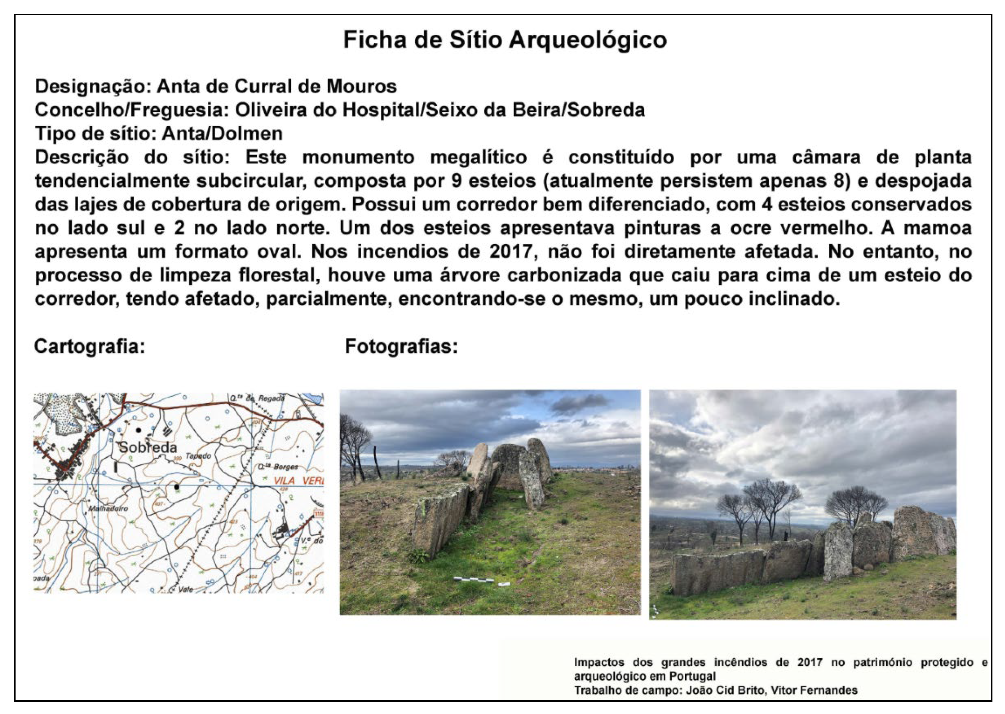
After carrying out this work, the municipality team concluded that the impact of the October 2017 fire to the protected and archaeological heritage of Oliveira do Hospital was null or very low. The only directly impacted building was the chapel Capela de São Bartolomeu, located next to the homonymous archaeological site. As previously mentioned, some of the identified assets are archaeological sites consisting of graves dug in the rock, where the only evidence of the event is the presence of soot on the outcrop where the graves are inscribed. On the other hand, some of the archaeological sites were indirectly impacted; for example, at the dolmen Anta de Curral de Mouros, during the forest clearing process, a charred tree fell onto one of the pillars of the access corridor to the funeral chamber, tilting it.
3.4. Pampilhosa da Serra
The municipality of Pampilhosa da Serra stated that no assets were affected by the event, although no field surveys were performed to confirm that assertion.
3.5. Tábua
The municipality of Tábua provided information at the parish level. Accordingly, the municipality team reported that nine out of the fifteen parishes of Tábua were either not affected by the October 2017 fire or do not have known archaeological sites. In the parishes of São João da Boa Vista and Sinde, the fire is reported to have been relatively mild, causing some damage to property but not to protected cultural heritage or archaeological sites. The four remaining parishes (Covas, Midões, Tábua and Vila Nova de Oliveirinha) were heavily impacted by the event, affecting some assets but with no significant damage to report; these included two listed assets with public interest status, the Sumes roman bridge in the Midões parish, and the Pedra da Sé roman pathway in the Tábua parish. In general, some of the affected archaeological sites only became more visible after the event. The municipality of Tábua noted that its survey had a general scope and did not specifically address cultural heritage.
Upon further interaction with the municipality team, they also reported that some of the existing manor houses, important at the local level, burned down and remained so as of November 2019, such as the manor house of Ribeirinho, the manor house of Esporão, and Palácio Valverde (Figure 6). Many of these houses burned in the village centre of Midões, which was attributed to two main reasons: (1) the violence of the fire caused several projections towards the centre of the village; (2) the poor state of conservation (e.g., broken roofs and/or windows) or even abandonment of some properties, including lack of land clearing.
3.6. Vouzela
The municipality of Vouzela analysed the list of potentially affected assets provided by our team and complemented it with additional information; specifically, the assets were categorised as follows:
- -
- Affected (forestry work): damage caused by moving machinery during cutting operations of burnt wood;
- -
- At risk (forestry work): includes risks arising from cutting operations of burnt wood and/or soil mobilisation for reforestation;
- -
- Undetermined: the site in question has not yet been located by municipality services and it is not possible to determine its state of conservation;
- -
- Nonexistent: database errors, possibly due to repeated inventorying of the same site but with different names.
Furthermore, the municipality team added seven assets classified as affected or at risk due to forestry work that were not present in the initial list. Regarding these two categories, in total, two assets were identified as affected (the Abelheira and Adside megalithic monuments) and twelve were identified as at risk. No assets were identified as directly damaged by the fire itself. The municipality provided a photograph of one of the archaeological sites located in the area affected by the fire (Lapa de Meruge), which is shown in Figure 7.
4. Discussion
The data collected from the six municipalities presented in Section 3 constitutes a representative sample of information regarding the impacts of the October 2017 wildfires. This information provides relevant insights into different issues that are important to understand in the context of the risk management of cultural heritage. Accordingly, based on the information presented before, in the section we: (1) discuss existing procedures at the municipal level to manage cultural heritage data and record disaster impacts; (2) discuss the reliability of geospatial analyses at the large scale to identify cultural heritage potentially affected by wildfires; and (3) summarise the types of impacts that the October 2017 event had on cultural heritage, based on the available data.
Regarding the first point, our interactions with the municipalities and the information we were provided with highlighted that the level of knowledge on local cultural heritage tends to vary among municipalities; for example, not every municipality has a database of local cultural heritage assets. This influenced the approach adopted by each municipality to collect and provide data for this study, as well as the level of detail of that information. For example, the municipality of Oliveira do Hospital used the list of potentially affected assets provided by our team as the main reference for selecting which sites to survey and assess; Vouzela provided information based on the same list of assets but complemented it with additional assets; and Gouveia performed an assessment based on its internal database. It should be noted, as mentioned in Section 2, that there are assets which despite not possessing listed status are still relevant from a local-level cultural viewpoint, and therefore should not be disregarded in risk management initiatives. Although these types of assets are not always registered in a structured digital database of cultural heritage, their local value is recognised and well known by locals. Nevertheless, some municipalities, such as Gouveia, do include these assets in their databases of local cultural heritage. Ultimately, municipalities appear to have different levels of awareness regarding the importance of cultural heritage, different resources available for managing local cultural heritage and/or different degrees of specialisation regarding cultural and archaeological heritage; for example, not all municipalities have archaeologists on their teams. Accordingly, for this study, some municipalities performed comprehensive field surveys to investigate and record the potential impacts of the 2017 fire on local cultural heritage, particularly on archaeological sites located outside human settlements, but this was not the case for all municipalities. Subsurface archaeological materials were not investigated, although these may also be affected during wildfires [6].
Another critical aspect refers to how cultural heritage disaster impact and loss information is recorded and reported. Despite the importance of disaster loss data to support the assessment and management of risk in any sector, there is a lack of internationally agreed definitions or accounting practices for such data [10]. Moreover, the collection and recording of the consequences of disasters are often performed by different institutions or government departments with different objectives and rules depending on the types of event and/or assets affected [9]. These problems are exacerbated in the case of cultural heritage assets, where there is no agreed-upon method to quantify disaster losses, and loss data tend to be scarce [19,20,35,39]. The data provided by the municipalities for this study, described in Section 3, confirm these well-known issues to some extent. Here, the biggest challenge is related to the lack of a clear and common approach to report and describe the impacts of the event on the cultural heritage assets under analysis. For example, the word “affected” often appears in the information provided by the municipalities, albeit without a clear definition of its intended meaning and without consistency among the municipalities. In fact, in some cases, the reference to “affected” refers simply to the fact that the fire passed through the location of the asset regardless of any damage it may have caused, whereas in other cases, it refers to some form of actual impact. The lack of definitions for the provided descriptions of impacts also occurs, for example, in the scale used by the municipality of Gouveia to describe such impacts—i.e., “affected”, “very affected”, “destructive impacts”—whereas in the case of Oliveira do Hospital, impacts are often described as “minor” and “none” although it is not evident if these two terms are used interchangeably or not. Another illustrative issue is present in the list of assets provided by the municipality of Vouzela, where some assets do not have a category assigned to them, although it is not clear what this means (e.g., not hit by the fire, not impacted or not visited). It would also be relevant to perform more detailed analyses on the effects of the fire for certain assets (e.g., [40]), although such actions do not necessarily need to be carried out as part of larger-scale assessment surveys shortly after the event, but rather at a subsequent stage and for a more limited number of assets identified as the most impacted. Naturally, situations such as the ones described above hamper a precise understanding of disaster impacts within and among municipalities and, consequently, subsequent risk management efforts. We must highlight that these examples do not intend to criticise the data-reporting efforts of the municipalities that participated in the present study; on the contrary, they are invaluable contributions. As previously mentioned, the lack of a standardised approach for loss data collection is still the reality worldwide across most sectors, and it is with research initiatives such as this one, with the active contribution of local stakeholders, that this issue can be better understood and gradually addressed. This will require working towards a harmonisation of local practices and a standardised approach for data recording. Moreover, the collection of cultural heritage loss data needs to become a common practice across local stakeholders; currently, and in most cases, obtaining such data requires establishing contacts with local stakeholders shortly after an event, otherwise such information is likely to be lost.
The second point identified above concerns the reliability of the analyses in geographic information systems to identify cultural heritage potentially affected by wildfires. In order to investigate this issue, we compared the list of potentially affected assets obtained using the methodology described in Section 2 with the information received by the municipalities. As expected, there is not a perfect match between the former and the lists of assets identified by the municipalities as having been in contact with the fire, which can be attributed to two main reasons. Firstly, as previously described, there is some uncertainty in the mapping of burnt areas at the large scale. Concerning this issue, an illustrative example is the case of Igreja de Vila Cova de Alva in Arganil, which was damaged by the fire despite not initially identified as potentially affected due to being located outside the CEMS burnt area map. Secondly, local information on cultural heritage is, in some cases, more reliable than data obtained from national databases, e.g., due to inaccurate geographic positioning, such as the case of Calçada dos Galhardos, which according to the Gouveia municipality is wrongly located in Portal do Arqueólogo. In addition, locally obtained information often comprises unlisted assets with a certain local relevance (as mentioned previously) that are typically not found in national databases (e.g., the manor houses in Arganil and Tábua). We found the largest discrepancy between the analysis in GIS and local information for the municipality of Pampilhosa da Serra, although in this specific case such information may not be entirely reliable as it was not based on any form of field survey. Overall, based on the results obtained for this case study, we conclude that notwithstanding the previously described limitations, it is possible to identify cultural heritage assets potentially affected by wildfires using large-scale datasets with a reasonable degree of confidence. However, we believe that a more sensible approach is to first identify the affected municipalities (i.e., containing potentially affected cultural heritage) based on a GIS, and then perform a more detailed data collection campaign directly with local stakeholders. This approach also allows collecting specific information about the actual impacts, which would be very difficult to estimate based exclusively on a large-scale analysis. Naturally, some of these issues could be alleviated by improving the quality of national databases and/or disaster loss reporting practices, as previously mentioned.
Alongside these reliability concerns, the current discussion needs to highlight another source of uncertainty imbedded in the dataset of archaeological heritage. As referred before, areas for which the dataset does not contain archaeological sites can mean that these areas were previously surveyed and no sites were found, or that these areas were not previously surveyed. Since the data available in Portal do Arqueólogo does not include this information, the identification of potentially affected archaeological sites may not be exhaustive given that certain areas of some of the municipalities exhibit a low density of archaeological sites. Although information on this issue was unable to be obtained for the present study, the quality and usefulness of the data available in Portal do Arqueólogo could be improved by including a layer indicating the areas that have been surveyed for archaeological sites in the past.
Lastly, and concerning the third point, it can be observed that despite the extreme nature of the 2017 wildfires both in terms of the physical phenomenon and of its consequences, the impacts of the event on cultural heritage were not particularly severe. In terms of architectural heritage, the only damaged asset with listed status was a church in Arganil. In addition, a few unlisted manor houses with local cultural relevance in Arganil and Tábua were also damaged. The relatively low number of damaged architectural elements is undoubtedly linked to the fact that this type of asset is most often located within urban settlements, which tend to be less affected than their surroundings during wildfires. Regarding archaeological heritage, even if most assets are located in forest areas that were significantly affected by the fire, notwithstanding the previously discussed concerns about the reliability of the dataset, the impacts were generally low, with only slight damage reported for a few assets. This is due to the fact that the prevalent material in most such assets is stone, which has a relatively low susceptibility to fire; nevertheless, it must be highlighted that fire may cause micro-scale mineralogical and textural changes that can contribute to subsequent decay processes [41,42]. On the other hand, indirect impacts—either already occurred or with the potential for future occurrence—were reported for several archaeological sites. Such impacts are related mainly to the erosion of soil that was previously protected by vegetation, affecting its stability, and to post-event forestry activities, such as cutting and hauling burnt wood, reforestation or improving forest infrastructure (e.g., dirt roads, firebreaks) [43,44,45]. Thus, the potential indirect impacts of wildfires on archaeological sites located in forest areas should be given particular attention in the risk management of cultural heritage.
In conclusion, it is evident that there are different types of stakeholders in Portugal who are conscious of the importance of adequate wildfire risk management for cultural heritage assets, as well as the relevance of collecting asset and loss data after such events [24,43,44,45]. Nevertheless, there is still room for significantly improving the effectiveness of such actions, which calls for improved knowledge and awareness supported by research efforts such as the one presented in this article.
Author Contributions
Conceptualisation, R.F., E.P. and X.R.; methodology, R.F., E.P. and X.R.; investigation, R.F., E.P. and X.R.; writing—original draft preparation, R.F.; writing—review and editing, R.F., E.P. and X.R.; visualisation, R.F. All authors have read and agreed to the published version of the manuscript.
Funding
This work was financially supported by: Project POCI-01-0145-FEDER-030469—RIACT—Risk Indicators for the Analysis of Cultural heritage under Threat, funded by FEDER through COMPETE2020—Programa Operacional Competitividade e Internacionalização (POCI) and by national funds through FCT—Fundação para a Ciência e a Tecnologia, Portugal; and by Base Funding—UIDB/04708/2020 of CONSTRUCT—Instituto de I&D em Estruturas e Construções, funded by national funds through FCT/MCTES (PIDDAC), Portugal.
Data Availability Statement
The data used to perform the geospatial analyses are available through the references provided in the article.
Acknowledgments
The authors would like to thank the municipalities of Arganil, Gouveia, Oliveira do Hospital, Pampilhosa da Serra, Tábua and Vouzela for the information provided to support this study.
Conflicts of Interest
The authors declare no conflict of interest.
References
- Tedim, F.; Leone, V.; Amraoui, M.; Bouillon, C.; Coughlan, M.; Delogu, G.; Fernandes, P.; Ferreira, C.; McCaffrey, S.; McGee, T.; et al. Defining Extreme Wildfire Events: Difficulties, Challenges, and Impacts. Fire 2018, 1, 9. [Google Scholar] [CrossRef] [Green Version]
- Moritz, M.A.; Batllori, E.; Bradstock, R.A.; Gill, A.M.; Handmer, J.; Hessburg, P.F.; Leonard, J.; McCaffrey, S.; Odion, D.C.; Schoennagel, T.; et al. Learning to Coexist with Wildfire. Nature 2014, 515, 58–66. [Google Scholar] [CrossRef] [PubMed]
- Moritz, M.A.; Parisien, M.-A.; Batllori, E.; Krawchuk, M.A.; Van Dorn, J.; Ganz, D.J.; Hayhoe, K. Climate Change and Disruptions to Global Fire Activity. Ecosphere 2012, 3, 1–22. [Google Scholar] [CrossRef]
- Bowman, D.M.J.S.; Williamson, G.J.; Abatzoglou, J.T.; Kolden, C.A.; Cochrane, M.A.; Smith, A.M.S. Human Exposure and Sensitivity to Globally Extreme Wildfire Events. Nat. Ecol. Evol. 2017, 1, 0058. [Google Scholar] [CrossRef] [PubMed]
- Mallinis, G.; Mitsopoulos, I.; Beltran, E.; Goldammer, J. Assessing Wildfire Risk in Cultural Heritage Properties Using High Spatial and Temporal Resolution Satellite Imagery and Spatially Explicit Fire Simulations: The Case of Holy Mount Athos, Greece. Forests 2016, 7, 46. [Google Scholar] [CrossRef] [Green Version]
- Ryan, K.C.; Jones, A.T.; Koerner, C.L.; Lee, K.M. Wildland Fire in Ecosystems: Effects of Fire on Cultural Resources and Archaeology; U.S. Department of Agriculture, Forest Service, Rocky Mountain Research Station: Fort Collins, CO, USA, 2012; Volume 3.
- Ryan, K.C. Effects of Fire on Cultural Resources. In VI International Conference on Forest Fire Research; Viegas, D.X., Ed.; Rocky Mountain Research Station: Coimbra, Portugal, 2010. [Google Scholar]
- Poljanšek, K.; Ferrer, M.M.; De Groeve, T.; Clark, I. Science for Disaster Risk Management 2017: Knowing Better and Losing Less; Publications Office of the European Union: Luxembourg, 2017. [Google Scholar]
- Romão, X.; Paupério, E.; Figueiredo, R. A Importância Da Informação Sobre Os Impactos Das Catástrofes—Enquadramento No Projeto Europeu LODE. In Estudos Cindínicos—Madeira Região Resiliente. Aprender com o Passado; Lourenço, L., Dias, J., Eds.; Estudos Cindínicos; RISCOS—Associação Portuguesa de Riscos, Prevenção e Segurança: Coimbra, Portugal, 2020; Volume 9, pp. 267–282. [Google Scholar] [CrossRef]
- De Groeve, T.; Poljansek, K.; Ehrlich, D.; Corbane, C. Current Status and Best Practices for Disaster Loss Data Recording in EU Member States: A Comprehensive Overview of Current Practice in the EU Member States; Publications Office of the European Union: Luxembourg, 2014. [Google Scholar] [CrossRef]
- CHCfE Consortium. Cultural Heritage Counts for Europe; International Cultural Centre: Krakow, Poland, 2015. [Google Scholar]
- Figueiredo, R.; Romão, X.; Paupério, E. Component-Based Flood Vulnerability Modelling for Cultural Heritage Buildings. Int. J. Disaster Risk Reduct. 2021, 61, 102323. [Google Scholar] [CrossRef]
- UNESCO. Strategy for Reducing Risks from Disasters at World Heritage Properties (WHC-07/31.COM/7.2); UNESCO: Paris, France, 2007. [Google Scholar]
- United Nations. Transforming Our World: The 2030 Agenda for Sustainable Development (A/RES/70/1); United Nations: New York, NY, USA, 2015. [Google Scholar]
- United Nations. Sendai Framework for Disaster Risk Reduction 2015–2030; United Nations Office for Disaster Risk Reduction (UNISDR): Sendai, Japan, 2015. [Google Scholar]
- Drdácký, M.; Binda, L.; Herle, I.; Lanza, L.G.; Maxwell, I.; Pospíšil, S. Protecting the Cultural Heritage from Natural Disasters; European Parliament: Brussels, Belgium, 2007. [Google Scholar]
- Cacciotti, R.; Kaiser, A.; Sardella, A.; De Nuntiis, P.; Drdácký, M.; Hanus, C.; Bonazza, A. Climate Change-Induced Disasters and Cultural Heritage: Optimizing Management Strategies in Central Europe. Clim. Risk Manag. 2021, 32, 100301. [Google Scholar] [CrossRef]
- Bonazza, A.; Maxwell, I.; Drdácký, M.; Vintzileou, E.; Hanus, C. Safeguarding Cultural Heritage from Natural and Man-Made Disasters—A Comparative Analysis of Risk Management in the EU; European Commission: Brussels, Belgium, 2018. [Google Scholar] [CrossRef]
- Romão, X.; Paupério, E. An Indicator for Post-Disaster Economic Loss Valuation of Impacts on Cultural Heritage. Int. J. Archit. Herit. 2021, 15, 678–697. [Google Scholar] [CrossRef]
- Romão, X.; Paupério, E.; Monserrat, O.; Rousakis, T.; Montero, P. Assets at Risk and Potential Impacts: 3.6—Cultural Heritage. In Science for Disaster Risk Management 2020: Acting Today, Protecting Tomorrow; Casajus Valles, A., Marin Ferrer, M., Poljanšek, K., Clark, I., Eds.; Publications Office of the European Union: Luxembourg, 2020; pp. 503–525. [Google Scholar] [CrossRef]
- Mateus, P.; Fernandes, P.M. Forest Fires in Portugal: Dynamics, Causes and Policies. In Forest Context and Policies in Portugal; Reboredo, F., Ed.; Springer: Berlin, Germany, 2014; pp. 97–115. [Google Scholar] [CrossRef]
- Turco, M.; Jerez, S.; Augusto, S.; Tarín-Carrasco, P.; Ratola, N.; Jiménez-Guerrero, P.; Trigo, R.M. Climate Drivers of the 2017 Devastating Fires in Portugal. Sci. Rep. 2019, 9, 13886. [Google Scholar] [CrossRef] [PubMed]
- Viegas, D.X.; Almeida, M.A.; Ribeiro, L.M.; Raposo, J.; Viegas, M.T.; Oliveira, R.; Alves, D.; Pinto, C.; Rodrigues, A.; Ribeiro, C.; et al. Análise Dos Incêndios Florestais Ocorridos a 15 de Outubro de 2017; University of Coimbra: Coimbra, Portugal, 2019. [Google Scholar]
- Bragança, F.; Zambujo, G.; Lourenço, S.; Paiva, B.; Banha, C.; Regala, F.T.; Moura, H.; Bugalhão, J.; Marques, J.; Correia, J.; et al. Salvaguarda de Património Arqueológico Em Operações Florestais: Gestão e Sensibilização. In Arqueologia em Portugal 2020—Estado da Questão; Arnaud, J.M., Neves, C., Martins, A., Eds.; Associação dos Arqueólogos Portugueses e CITCEM: Lisbon, Portugal, 2020; pp. 165–178. [Google Scholar] [CrossRef]
- Chuvieco, E.; Mouillot, F.; van der Werf, G.R.; San Miguel, J.; Tanase, M.; Koutsias, N.; García, M.; Yebra, M.; Padilla, M.; Gitas, I.; et al. Historical Background and Current Developments for Mapping Burned Area from Satellite Earth Observation. Remote Sens. Environ. 2019, 225, 45–64. [Google Scholar] [CrossRef]
- Dorati, C.; Kucera, J.; Rivero, I.M.I.; Wania, A. Product User Manual for Copernicus EMS Rapid Mapping; JRC Technical Report JRC111889; European Commission: Ispra, Italy, 2018. [Google Scholar]
- European Commission. Copernicus EMS-Mapping. Portfolio: Rapid Mapping. Available online: https://emergency.copernicus.eu/mapping/ems/rapid-mapping-portfolio (accessed on 12 July 2021).
- European Commission. Copernicus EMS-Mapping. EMSR250: Forest Fire Portugal. Available online: https://emergency.copernicus.eu/mapping/list-of-components/EMSR250 (accessed on 12 July 2021).
- European Commission. Copernicus EMS-Mapping. [EMSR250] Nelas: Delineation Map. Available online: https://emergency.copernicus.eu/mapping/ems-product-component/EMSR250_03NELAS_01DELINEATION_MAP/2 (accessed on 12 July 2021).
- Presidência do Conselho de Ministros. Decreto-Lei n.º 43/2019 - Aprova a orgânica do Instituto da Conservação da Natureza e das Florestas, I. P. Diário da República n.º 63/2019, Série I de 2019-03-29; Portugal, 2019; pp. 1170–1776. [Google Scholar]
- Instituto da Conservação da Natureza e das Floresta. Cartografia Nacional de Áreas Ardidas dos Anos 1975 à Data Atual em Conformidade Com o Disposto no n.o 5 Do Art.o 2.o do Decreto-Lei n.o 124/2006, de 28 de Junho, na Redação Dada Pelo Decreto-Lei n.o 17/2009, de 14 de Janeiro. Available online: https://sig.icnf.pt/portal/home/item.html?id=983c4e6c4d5b4666b258a3ad5f3ea5af (accessed on 12 July 2021).
- Instituto da Conservação da Natureza e das Florestas. Shapefile Área Ardida 2017. Available online: http://www.icnf.pt/portal/florestas/dfci/Resource/doc/cart/2019-08-14-AARDIDA_2017.zip (accessed on 12 July 2021).
- Noé, P. O SIPA—Sistema de Informação Para o Patrimônio Arquitetônico—Em Portugal. Rev. CPC 2016, esp21, 67–98. [Google Scholar] [CrossRef] [Green Version]
- Assembleia da República. Lei n.º 107/2001 - Estabelece as bases da política e do regime de protecção e valorização do património cultural. Diário da República n.o 209/2001, Série I-A de 2001-09-08; Portugal, 2001; pp. 5808–5829. [Google Scholar]
- Figueiredo, R.; Romão, X.; Paupério, E. Flood Risk Assessment of Cultural Heritage at Large Spatial Scales: Framework and Application to Mainland Portugal. J. Cult. Herit. 2020, 43, 163–174. [Google Scholar] [CrossRef]
- DGPC. Endovélico Inventory. Available online: http://www.patrimoniocultural.gov.pt/en/patrimonio/patrimonio-imovel/patrimonio-arqueologico/endovelico-inventario/ (accessed on 12 July 2021).
- DGPC. Archaeologist’s Portal. Available online: http://www.patrimoniocultural.gov.pt/en/patrimonio/patrimonio-imovel/patrimonio-arqueologico/gestao-da-atividade-arqueologica/portal-do-arqueologo/ (accessed on 12 July 2021).
- Divisão de Inventário do Instituto Português de Arqueologia. Endovélico: Sistema de Gestão e Informação Arqueológica. Rev. Port. Arqueol. 2002, 5, 277–283. [Google Scholar]
- Drdácký, M.F. Flood Damage to Historic Buildings and Structures. J. Perform. Constr. Facil. 2010, 24, 439–445. [Google Scholar] [CrossRef]
- Pozo-Antonio, J.S.; Sanmartín, P.; Serrano, M.; De la Rosa, J.M.; Miller, A.Z.; Sanjurjo-Sánchez, J. Impact of Wildfire on Granite Outcrops in Archaeological Sites Surrounded by Different Types of Vegetation. Sci. Total Environ. 2020, 747, 141143. [Google Scholar] [CrossRef] [PubMed]
- Gomez-Heras, M.; McCabe, S.; Smith, B.J.; Fort, R. Impacts of Fire on Stone-Built Heritage. J. Archit. Conserv. 2009, 15, 47–58. [Google Scholar] [CrossRef]
- Luís, L. Incêndios Florestais e o Seu Impacto No Património Mundial: O Caso de Foz Côa. In Desafios na Gestão de Riscos em Património Cultural; Ramirez, C.E., Paupério, E., Romão, X., Eds.; Faculdade de Engenharia da Universidade do Porto, Instituto da Construção, Junta de Castilla y Leon, Unidad de Gestión de Riesgos y Emergencias de Patrimonio Cultural da Junta de Castilla y Leon: Porto, Portugal, 2017; pp. 62–77. [Google Scholar]
- Real, F. Os Incêndios de 2003 e a Arqueologia Na Política Da Ordenamento Florestal. Al-Madan 2003, II, 202–203. [Google Scholar]
- Delgado, C.; Oosterbeek, L.; Cruz, A. Incêndios 2003: Estratégias e Resultados. Arkeos Perspect. em Diálogo 2006, 16, 77–88. [Google Scholar]
- Caninas, J.; Henriques, F.; Branco, P.C. Contributos Para Uma Caracterização Do Impacte Dos Fogos Florestais de 2003 Sobre o Património Arqueológico e o Património Construído No Distrito de Castelo Branco. Açafa On-line 2008, 1, 1–13. [Google Scholar]
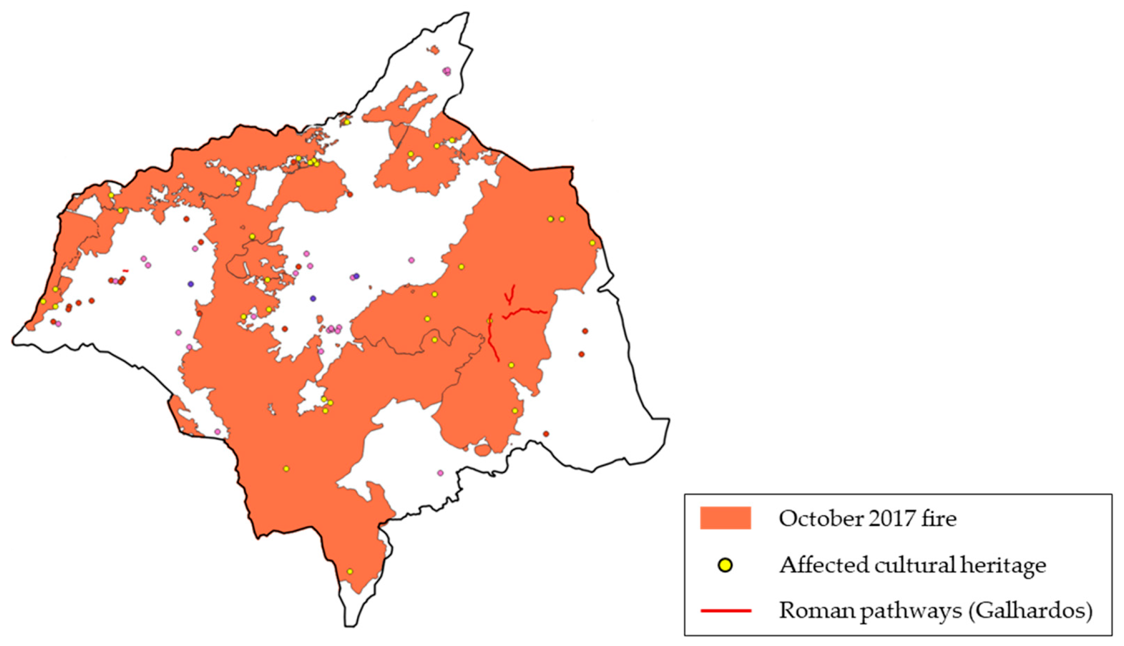
Figure 1.
Map of the estimated burnt areas relative to the October 2017 wildfire, locations of protected and archaeological assets within the Copernicus Area of Interest (with larger icons indicating assets overlapping burnt areas), and names of the municipalities with potentially affected cultural heritage assets.

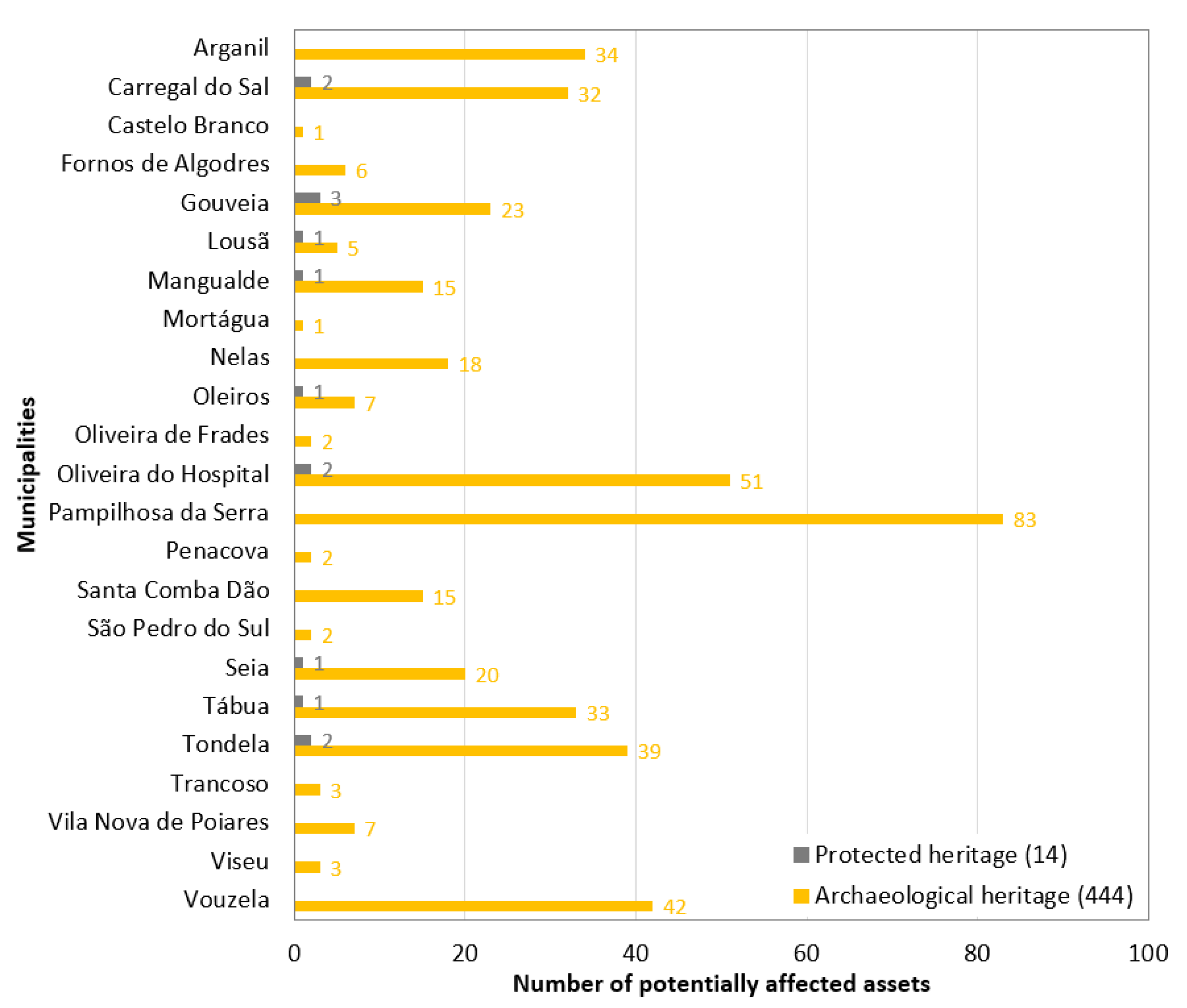
Figure 2.
Bar plot representing the number of protected and archaeological heritage assets identified as potentially affected by the October 2017 wildfire by municipality.
Figure 2.
Bar plot representing the number of protected and archaeological heritage assets identified as potentially affected by the October 2017 wildfire by municipality.

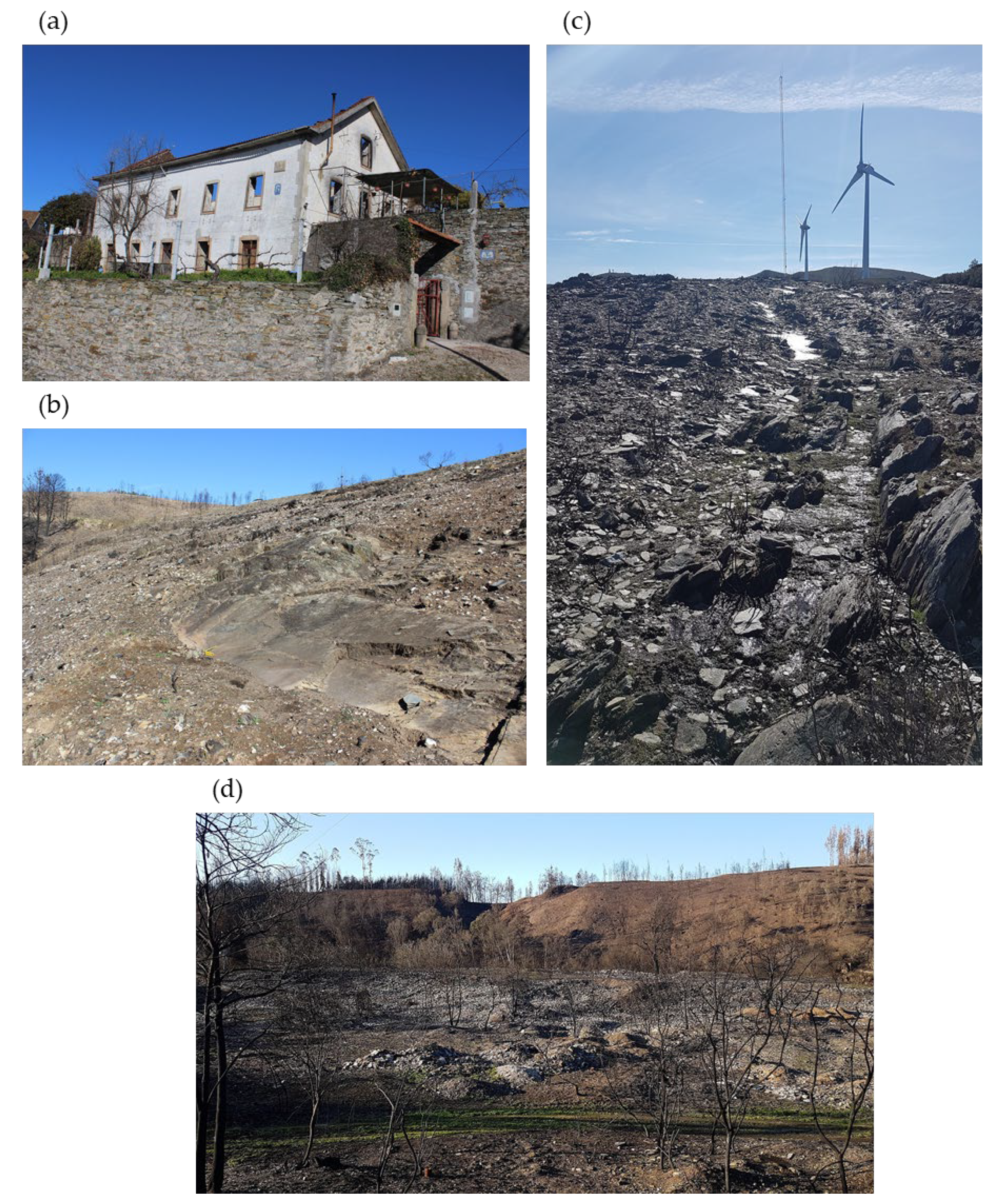
Figure 3.
Photographs of some of the cultural heritage assets affected by the October 2017 fire in the municipality of Arganil: (a) House with coat of arms in the parish of Cerdeira e Moura da Serra, which was heavily damaged by the fire; (b) Rock art in the parish of Benfeita; (c) Estrada Real medieval road; (d) Conheira (heaps of pebbles related to alluvial gold mining).

Figure 4.
Map provided by the municipality of Gouveia.

Figure 5.
Illustrative site sheet developed by the municipality of Oliveira do Hospital, relative to Anta de Curral de Mouros (dolmen). This asset was indirectly affected during the forest clearing process when a charred tree fell onto one of the pillars of the corridor accessing the funeral chamber and tilted it.

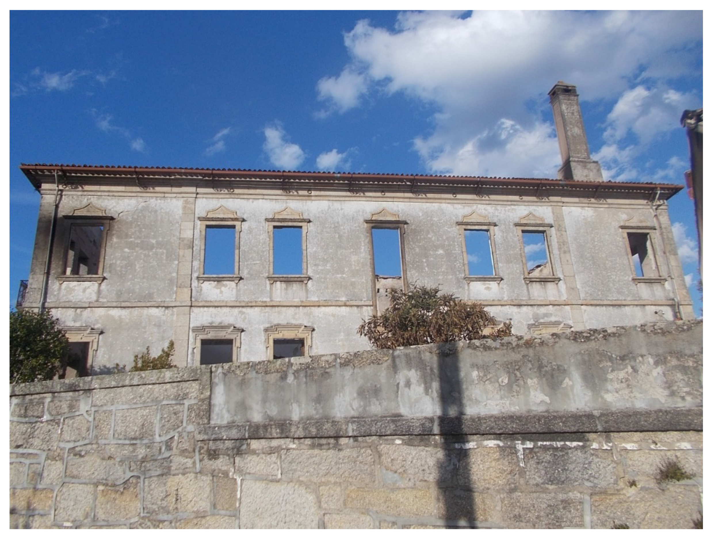
Figure 6.
Photograph of Palácio de Valverde after the October 2017 fire, during which it was heavily damaged.
Figure 6.
Photograph of Palácio de Valverde after the October 2017 fire, during which it was heavily damaged.

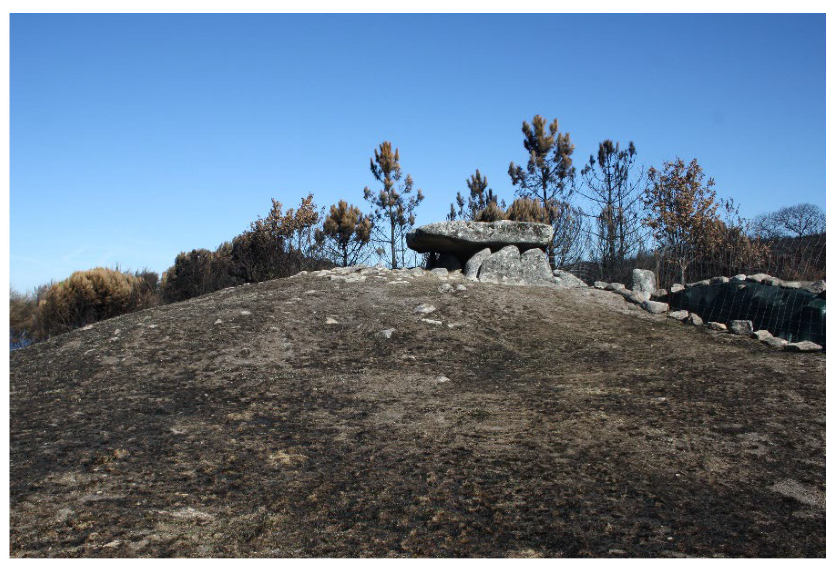
Figure 7.
Photograph of the Lapa de Meruge archaeological site after the October 2017 fire. Although this area was affected by the wildfire, the municipality reported no visible damage to the dolmen.
Figure 7.
Photograph of the Lapa de Meruge archaeological site after the October 2017 fire. Although this area was affected by the wildfire, the municipality reported no visible damage to the dolmen.


Table 1.
List of cultural heritage assets provided by the municipality of Gouveia. The ‘Visited’ column indicates the assets that were visited shortly after the event, i.e., between November 2017 and January 2018. The ‘Impact’ column refers to the levels of impact due to the event according to the following categories: 0—no structures on the surface; 1—not affected; 2—affected; 3—very affected; 4—destructive impacts.
| Toponym | Type | Listed Status | Municipal Classification | Visited | Impact |
|---|---|---|---|---|---|
| Igreja Matriz de Vinhó | Religious architecture | Public interest | Relevant built heritage | 1 | |
| Igreja Matriz de Folgosinho | Religious architecture | Relevant built heritage | 1 | ||
| Capela Sra. do Monte | Religious architecture | Relevant built heritage | 1 | ||
| Capela Sta. Eufémia | Religious architecture | Relevant built heritage | 1 | ||
| Casa do Judeu | Vernacular architecture | Relevant built heritage | 1 | ||
| Capela de Sta. Marta | Religious architecture | Public interest | Relevant built heritage | 1 | |
| Casa da Câmara | Civil architecture | Public interest | Relevant built heritage | 1 | |
| Pelourinho | Pillory | National monument | Relevant built heritage | 1 | |
| Paço de Melo | Civil architecture | Public interest | Relevant built heritage | 1 | |
| Castelo de Folgosinho | Castle | Public interest | Relevant built heritage | 1 | |
| Outeiro | Undefined | Public interest | Relevant built heritage | 1 | |
| Misericórdia | Religious architecture | Relevant built heritage | 1 | ||
| Capela S. Faustino | Religious architecture | Relevant built heritage | 1 | ||
| Capela S. Pedro | Religious architecture | Relevant built heritage | 1 | ||
| Solar Carvalho Cunha | Civil architecture | Relevant built heritage | 1 | ||
| Solar Bento de Moura | Civil architecture | Relevant built heritage | 1 | ||
| Capela do Santíssimo | Religious architecture | Relevant built heritage | 1 | ||
| Capela Sra. do Porto | Religious architecture | Relevant built heritage | 1 | ||
| Igreja S. Isidoro | Religious architecture | Relevant built heritage | 1 | ||
| Solar | Civil architecture | Relevant built heritage | 1 | ||
| Tronco do Ferrador | Ethnographic | Ethnographic heritage | 1 | ||
| Galhardos | Pathway | Public interest | Ancient road network | ✓ | 4 |
| Ponte das Cantinas | Bridge | Ancient road network | ✓ | 2 | |
| Ponte do Aljão | Bridge | Ancient road network | ✓ | 1 | |
| Bravoíssa | Inscription | Archaeological site | 1 | ||
| Campo Redondo | Village | Archaeological site | ✓ | 1 | |
| Quinxozo | Tomb | Archaeological site | 1 | ||
| Tapada | Necropolis | Archaeological site | ✓ | 1 | |
| Regada/Bacelo | Undefined | Archaeological site | 0 | ||
| Chão do Pinto | Tomb | Archaeological site | 1 | ||
| Moita do Cume | Tomb | Archaeological site | 1 | ||
| Castelo | Walled village | Archaeological site | ✓ | 2 | |
| Fraga | Undefined | Archaeological site | 0 | ||
| Sítio da Horta | Undefined | Archaeological site | 0 | ||
| Pai Moço | Undefined | Archaeological site | 0 | ||
| Penedo da Marreca | Inscription | Archaeological site | 1 | ||
| Barroca Girabolhos | Inscription | Archaeological site | 1 | ||
| Lagar do Clergo | Winepress | Archaeological site | 1 | ||
| Monte dos Galhardos | Menhir | Archaeological site | 1 | ||
| Regada Grande | Necropolis | Archaeological site | ✓ | 1 | |
| Quinta dos Botos | Winepress | Archaeological site | 1 | ||
| Cama da Moura | Tomb | Archaeological site | 1 | ||
| Penedo dos Mouros | Residential | Archaeological site | 1 | ||
| Penedo dos Mouros | Tomb | Archaeological site | ✓ | 2 | |
| Quinta da Moira | Tomb | Archaeological site | 1 | ||
| Pedras da Forca | Forca | Relevant archaeological site | ✓ | 3 | |
| Castelo | Tomb | Relevant archaeological site | ✓ | 2 | |
| Casal São Pedro | Tomb | Relevant archaeological site | 1 | ||
| Vale do Rossim | Undefined | Relevant archaeological site | 0 | ||
| Castro Vedro | Village | Relevant archaeological site | ✓ | 3 | |
| Castelejo | Walled village | Relevant archaeological site | ✓ | 2 | |
| Risado/Arrasado | Necropolis | Relevant archaeological site | ✓ | 2 | |
| Castelo | Undefined | Relevant archaeological site | 1 | ||
| Lages Ruivas I | Winepress | Relevant archaeological site | ✓ | 1 | |
| Penedo dos Mouros | Roqueiro castle | Relevant archaeological site | ✓ | 2 | |
| Penedo dos Mouros | Residential | Relevant archaeological site | ✓ | 2 | |
| Quinta da Moira | Rock sanctuary | Relevant archaeological site | ✓ | 1 |
Table 2.
Synthesis of the information provided by the municipality of Oliveira do Hospital about the impacts of the October 2017 fire on cultural heritage assets.
Table 2.
Synthesis of the information provided by the municipality of Oliveira do Hospital about the impacts of the October 2017 fire on cultural heritage assets.
| Designation | Type | Impact |
|---|---|---|
| Aldeia das Dez | Treasure | None, as the moveable heritage was not exposed to the flames. |
| Alto Zambujeiro | Tomb | None or minor. |
| Ameal | Necropolis | None. |
| Anta da Arcaínha | Dolmen | Even though the nearby forest burned, the site was not directly affected. However, during the reforestation process promoted by a local association, the site was partially damaged. |
| Anta de Curral dos Mouros | Dolmen | Not directly affected. During the forest clearing process, a charred tree fell onto one of the pillars of the access corridor to the funeral chamber, tilting it. |
| Anta da Coitena/Pinheiro dos Abraços | Dolmen | None or minor. |
| Avô 3 | Pathway | None or minor. |
| Calçada medieval de Vila Pouca da Beira | Pathway | None or minor. |
| Casa do Penedo | Tower | None. |
| Castelo | Castle | None. |
| Castelo de Avô | Castle | None or minor. |
| Castelo Verde | Village | None or minor. |
| Digueifel e Digueifel 2 | Pebble heap | Minor, as the site was not directly affected. |
| Espinhal | Tomb | None, as the site was not affected by the fire. |
| Fiais da Beira | Fortified village | Colouring affected by the fire. |
| Mata das Forcas | Necropolis | One of the graves is not impacted, whereas the other may in the future be covered by forest remnants. |
| Olival dos Pobres | Tomb | The structure was not directly affected. Indirectly and as a consequence of the event, there are forest and agricultural remnants covering a part of the grave. |
| Passal 1 | Necropolis | None, as the religious building that this site is part of was also not affected. |
| Penedo do Gorgulão | Necropolis | None or minor. |
| Pinhal da Fonte do Rei | Tomb | The grave dug in the rock was not directly hit, although some soot is present as a result of the fire. Regarding its surroundings, forest remnants are present, which may affect the visibility of the site in the future. |
| Ponte Romana de Bobadela | Bridge | None or minor. |
| Quinta de Salgodins | Necropolis | No impacts from the fire, but the site is adjoined by undergrowth. |
| Quinta do Boco | Shrine | None. |
| Quinta da Moreira de Baixo | Necropolis | None or minor. |
| Quinta do Ribeiro Mouro | Necropolis | None, as the site was not affected by the fire. |
| Ruínas Romanas de Bobadela | City | None or minor. |
| Salgueiral | Necropolis | None. |
| Santa Ovaia | Isolated findings | Any possibly existing structures are underground; thus, the impacts were minor. |
| São Bartolomeu 1 e 2 | Misc. remains; Necropolis | The necropolis was occasionally affected by the soot present on the outcrops where the structures are inscribed. The uncontrolled growth of vegetation may hide the structures in the future. |
| São João | Necropolis | None, although the site is covered by dense vegetation. |
| São Pedro de Lourosa | Necropolis | No impact relatable to the event. |
| Tapada | Tomb | The grave dug in the rock was not directly hit, although some soot is present as a result of the fire. Regarding its surroundings, the archaeological site is covered by dense vegetation, threatening its identification in the future. |
| Tapada 1 | Tomb | The grave dug in the rock was not directly hit. Regarding its surroundings, the archaeological site is covered by dense vegetation, threatening its identification in the future. |
| Tapada do Adão | Rock art | None or minor. |
| Vale do Coito/Laje da Pereira | Tomb | None or minor. |
Publisher’s Note: MDPI stays neutral with regard to jurisdictional claims in published maps and institutional affiliations. |
© 2021 by the authors. Licensee MDPI, Basel, Switzerland. This article is an open access article distributed under the terms and conditions of the Creative Commons Attribution (CC BY) license (https://creativecommons.org/licenses/by/4.0/).
Share and Cite
MDPI and ACS Style
Figueiredo, R.; Paupério, E.; Romão, X. Understanding the Impacts of the October 2017 Portugal Wildfires on Cultural Heritage. Heritage 2021, 4, 2580-2598. https://doi.org/10.3390/heritage4040146
AMA Style
Figueiredo R, Paupério E, Romão X. Understanding the Impacts of the October 2017 Portugal Wildfires on Cultural Heritage. Heritage. 2021; 4(4):2580-2598. https://doi.org/10.3390/heritage4040146
Chicago/Turabian StyleFigueiredo, Rui, Esmeralda Paupério, and Xavier Romão. 2021. "Understanding the Impacts of the October 2017 Portugal Wildfires on Cultural Heritage" Heritage 4, no. 4: 2580-2598. https://doi.org/10.3390/heritage4040146