
Archaeological and Natural Indicators of Sea-Level and Coastal Changes: The Case Study of the Caesarea Roman Harbor


1
The Zinman Institute of Archaeology, University of Haifa, 199 Aba-Hushi Avenue, Haifa 3498838, Israel
2
The Leon Recanati Institute for Maritime Studies, University of Haifa, Mount Carmel, Haifa 3498838, Israel
3
Geological Survey of Israel, 32 Yeshayhu Leibowitz Street, Jerusalem 9692100, Israel
4
Department of Maritime Civilizations, University of Haifa, Mount Carmel, Haifa 3498838, Israel
5
The Haifa Center for Mediterranean History (HCMH), University of Haifa, Haifa 3498838, Israel
6
The Institute of Classical Studies, University of London, London WC1E 6BT, UK
7
Ruppin Academic Center, Faculty of Marine Sciences, Emek-Hefer 40250, Israel
*
Author to whom correspondence should be addressed.
Geosciences 2021, 11(8), 306; https://doi.org/10.3390/geosciences11080306
Submission received: 19 June 2021
/
Revised: 17 July 2021
/
Accepted: 19 July 2021
/
Published: 23 July 2021
(This article belongs to the Special Issue Geoarchaeological Indicators for Sea Level Research and Paleogeographic Reconstruction)
Abstract
:Archaeological and geomorphological features, as well as traces left by tsunamis, earthquakes, and vertical earth-crust displacements, are used to identify sea-level and coastal changes. Such features may be displaced, submerged or eroded by natural processes and human activities. Thus, identifying ancient sea levels and coastal changes associated with such processes may be controversial and often leads to misinterpretations. We exemplify the use of sediment deposits and sea-level and coastline indicators by discussing the enigmatic demise of the Roman harbor of Caesarea, one of the greatest marine constructions built in antiquity, which is still debated and not fully understood. It was suggested that the harbor destruction was mainly the result of either tectonic subsidence associated with a local, active fault line, or as a result of an earthquake/tsunami that struck the harbor. Here we examine and reassess the deterioration of the harbor in light of historical records, and geological, geomorphological and archaeological studies of natural and man-made features associated with the harbor. We show that the alleged evidence of an earthquakes or tsunami-driven damage to the outer breakwaters is equivocal. There is no supporting evidence for the assumed tectonic, active fault, nor is there a reliable historic account of such a catastrophic destruction. It is suggested that geo-technic failure of the breakwater’s foundations caused by a series of annual winter storms was the main reason for the destruction and ultimate collapse of the western basin of the harbor. The breakwaters were constructed on unconsolidated sand that was later washed away by storm waves and sea currents that frequently hit the Israeli coast and undercut the breakwaters. The pounding effect of the waves could have contributed to the destruction by scouring and liquefying the sandy seabed underlying the foundations. Tsunamis that may have hit Caesarea could have added to the deterioration of the breakwaters, but did not constitute the main cause of its destruction.
1. Introduction
Archaeological and geomorphological features are used to identify past sea-level and coastal changes, as well as the impact of natural events such as tsunamis, earthquakes, co-seismic and vertical crustal displacements. However, such features may be displaced, submerged, eroded and affected by natural processes and human activities, and thus should be interpreted with care. Moreover, identifying anthropogenic features on the seabed is sometimes deceptive. Scholars often report discoveries of questionable man-made structures on the seabed, sometimes associating them with mythological events such as the Biblical flood or the lost island of Atlantis. Dating of anthropogenic features on the sea bed and clarifying their function are often problematic, and thus evoke controversial discussions, sometimes involving misinterpretations.
Searching for ancient natural disasters in the archaeological and geological records has become a common trend in recent decades. Examples include the alleged identification of an early Holocene catastrophic flood of the Black Sea, which was associated with the Biblical flood [1]. Another research by Pareschi et al. [2,3,4] suggested that a catastrophic tsunami generated by the sector collapse of Mount Etna some 8300 years ago destroyed the now submerged Neolithic village of Atlit-Yam on the Mediterranean coast of Israel. As fascinating as this hypothesis is, no in-situ archaeological and geological finds support it [5]. The destructive tsunami events in the Indian Ocean (2004) and Japan (2011) have contributed to such trends of catastrophism [6]. However, extensive research that followed these recent events and others (e.g., Java 2009 and Chile 2010 tsunamis) have enriched the understanding of the tsunamigenic phenomena, including the deposition of tsunami sediments on land and at sea, and have thus enabled a more accurate identification of past events (e.g., [7,8,9,10]). Recently, on the basis of possible paleo-tsunami deposits in Dor, Israel, Shtienberg et al. [11] determined the existence of a tsunami that completely erased Pre-Pottery coastal Neolithic A-B settlements along the Israeli coast. However, the team noted that the validation of the proposed tsunami model is beyond the scope of their study and should be verified in follow-up investigations.
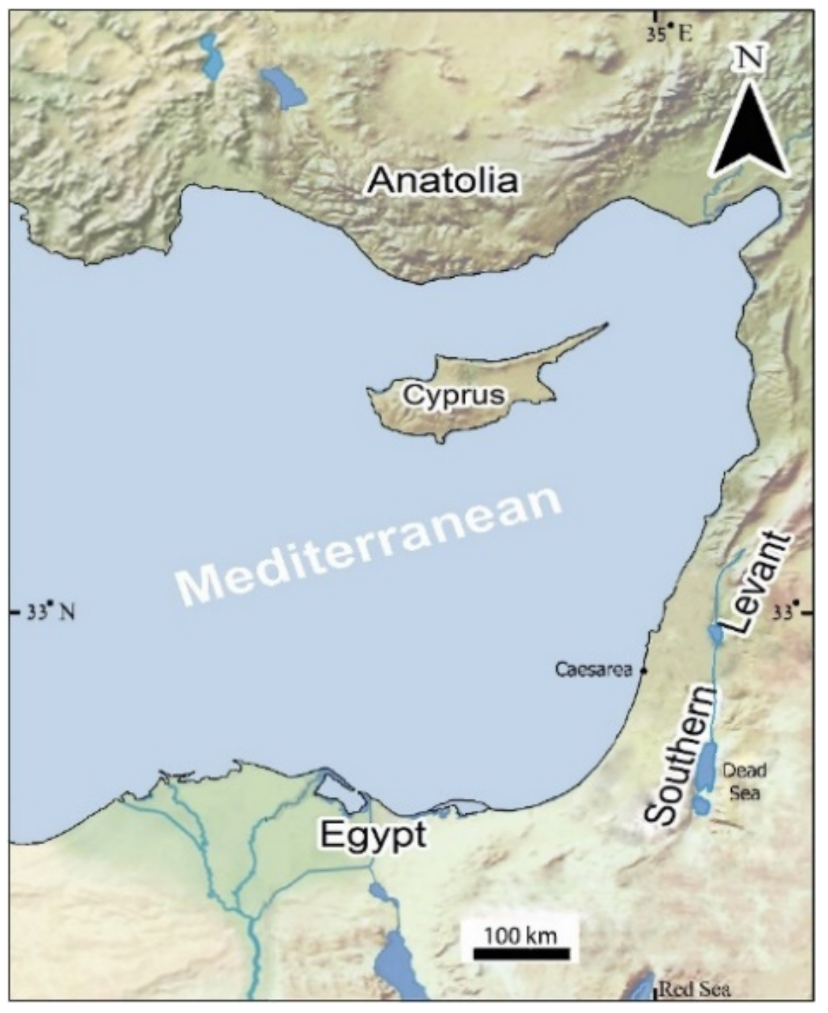
A detailed examination of archaeological and geological features associated with some of the proposed disasters indicates that they can also be explained as a lengthy, gradual change rather than a sudden event [6,12,13,14]. The present article discusses the use of archaeological and geomorphological features as sea-level and coastal markers and examines a case-study on the history of research of the destruction of the Herodian harbor of Caesarea (Figure 1) in light of the different theories associated with it.
2. The Use of Archaeological and Geomorphological Features as Sea-Level Markers
Sea-level indicators of different natures may be divided into the following categories: (a) Geological and geomorphological indications: marine deposits (e.g., beachrocks, marine carbonates), coastal sand barriers, marine notches and river deltas; (b) Biological indicators: marine mollusks, ooids, corals and reefs, coralline algae, vermetids gastropods, submerged forests, botanical macro remains, foraminifera, diatoms and ostracodes; (c) Anthropogenic archaeological features and deposits.
Holocene sea-level changes and coastal displacement along the Mediterranean coast of Israel have been investigated using archaeological indicators such as: water wells, coastal and submerged settlements and installations, harbors, quarries and shipwrecks (e.g., [12,13,15,16,17,18,19,20,21,22,23,24]). Sea-level indicators in Israel are usually divided into the following main time scales: (1) Indicators of the last interglacial high stand (120 ky BP), including consolidated beach deposits expected to be at maximum elevation of 6–7 m above global present sea levels; (2) Early Holocene (l0–6 ky BP), mainly remains of submerged Neolithic-Chalcolithic settlements; (3) Early historical periods (5–2 ky BP), such as shipwrecks, coastal and harbor installations, beach rock deposits, vermetid snails, wave notches and abrasion platforms; (4) The last 2000 years, indicators as above; (5) The 20th century; (6) The recent decade.
2.1. Holocene Depositional, Bio-Constructional and Erosional Sea-Level Markers
Natural sea-level markers can be divided roughly into three categories: depositional, constructional and erosional markers, which are associated with physical, chemical and biological effects.
In rocky coasts, three kinds of marine notches were classified by Pirazzoli (pp. 362–365, [25]): (a) tidal notch, formed in sheltered rocky areas in the intertidal zone; (b) infra-littoral notch, formed in the sub-tidal zone under exposed conditions and high surf; and (c) surf notch, formed under exposed conditions in the supra-littoral zone (supra-tidal zone). Abrasion platforms (shore platforms) are the product of marine corrosion that creates surf notches in exposed rocky coasts under long, stable sea-level conditions [26]. Marine bio constructions (incrustations such as vermetides, algae, etc.) protect the sub-littoral surface of the rock and the floor of the notch (p. 362, [25]), hence the massive corrosion of the rock occurs above sea level and the surface of the abrasion platform is close to the sea level. Holocene beachrocks, bio constructions, abrasion platforms and wave notches, which are associated with the sea-level elevation at the time of formation, are potential indicators for identifying relative sea level changes [24,27].
2.2. Archaeological Sea-Level Markers
Archaeological features associated with coastal and marine environments provide valuable information on vertical earth-crust changes and may be used as sea-level markers. The use of man-made features, such as sea level markers, is done after measuring their elevation relative to the present sea level, defining their functions and dating their time of construction [12,13,19,22,28,29,30,31,32,33,34,35].
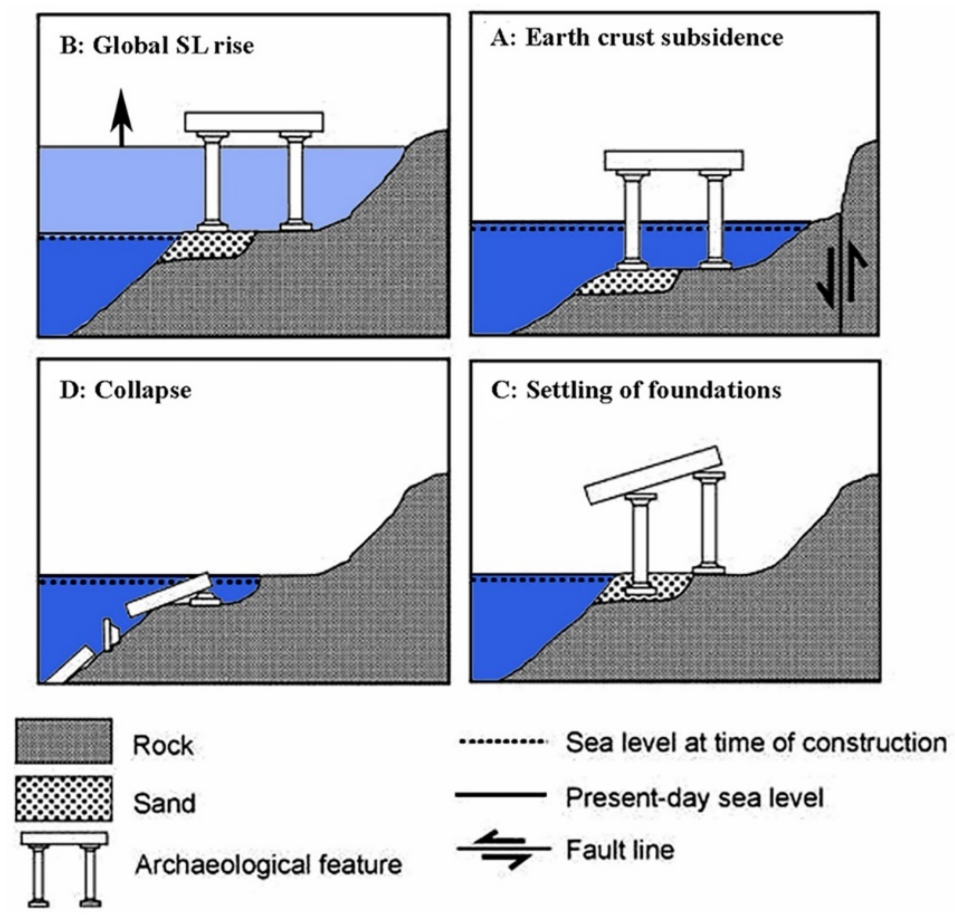
Ancient coastal man-made structures may be found at an elevation that would not enable functioning today for one or several reasons [12,13,29] (Figure 2): (a) global eustatic sea level rise or fall (Figure 2A); (b) earth crust vertical movements due to local tectonics, structural changes as well as isostasy (ice, water or sediment load, and rebound) (Figure 2B); (c) foundation settlements in unconsolidated sediments, compaction or liquefaction, or scoring of the underlying sediments (Figure 2C); (d) erosion and collapse of structures (Figure 2D).
Sedimentation and erosion may lead to a horizontal shift of the coastline and thus destroy structures or prevent their proper functioning, without any vertical sea-level or crustal changes. Many harbor structures were originally built underwater (e.g., the base of the “Island of Flies” in Akko [12]), thus, their use as sea-level markers may be challenging. Commonly, various combinations of the above factors are involved. Thus, interpreting paleo sea levels while relying solely on archaeological features should be done cautiously.
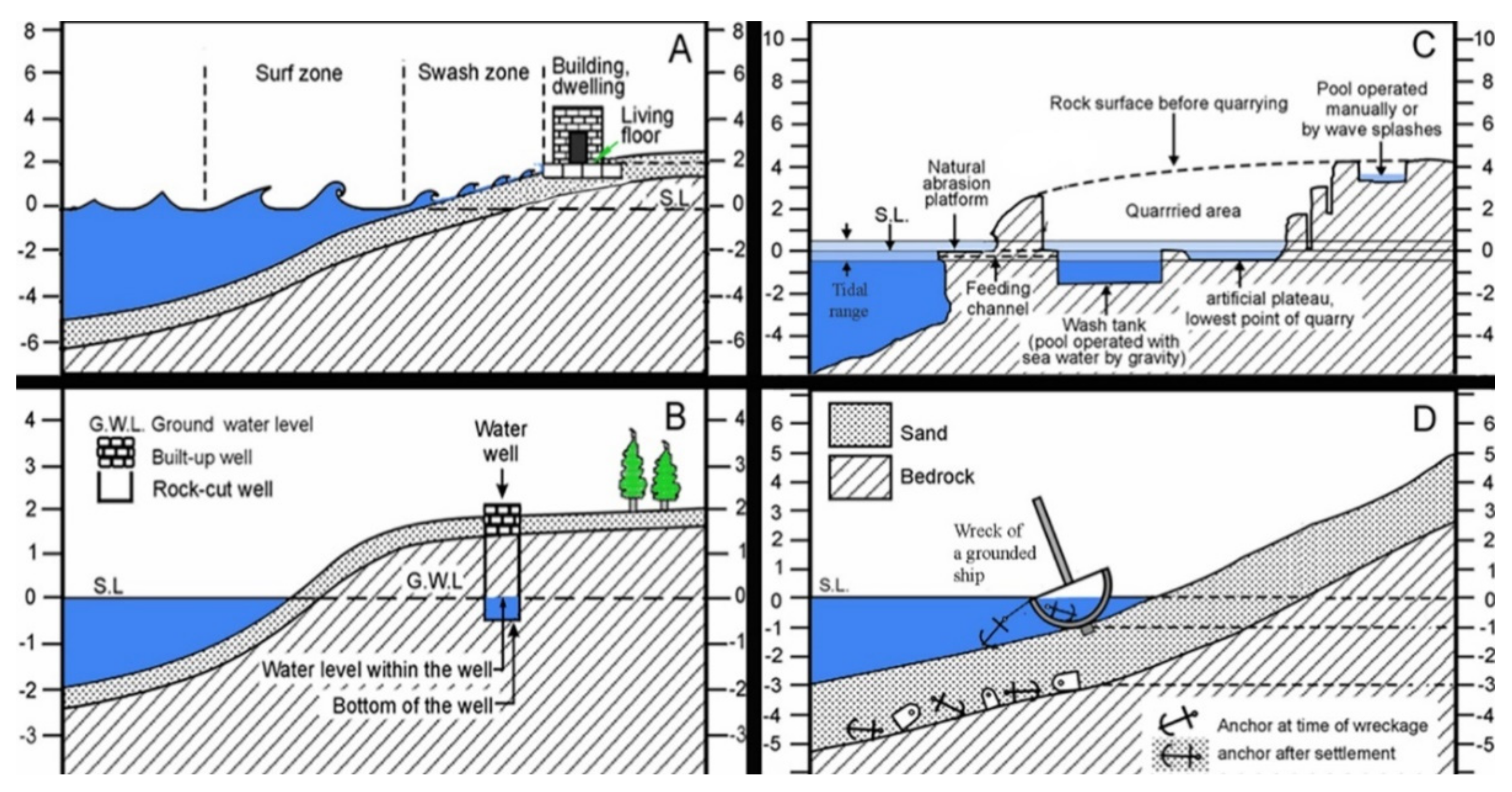
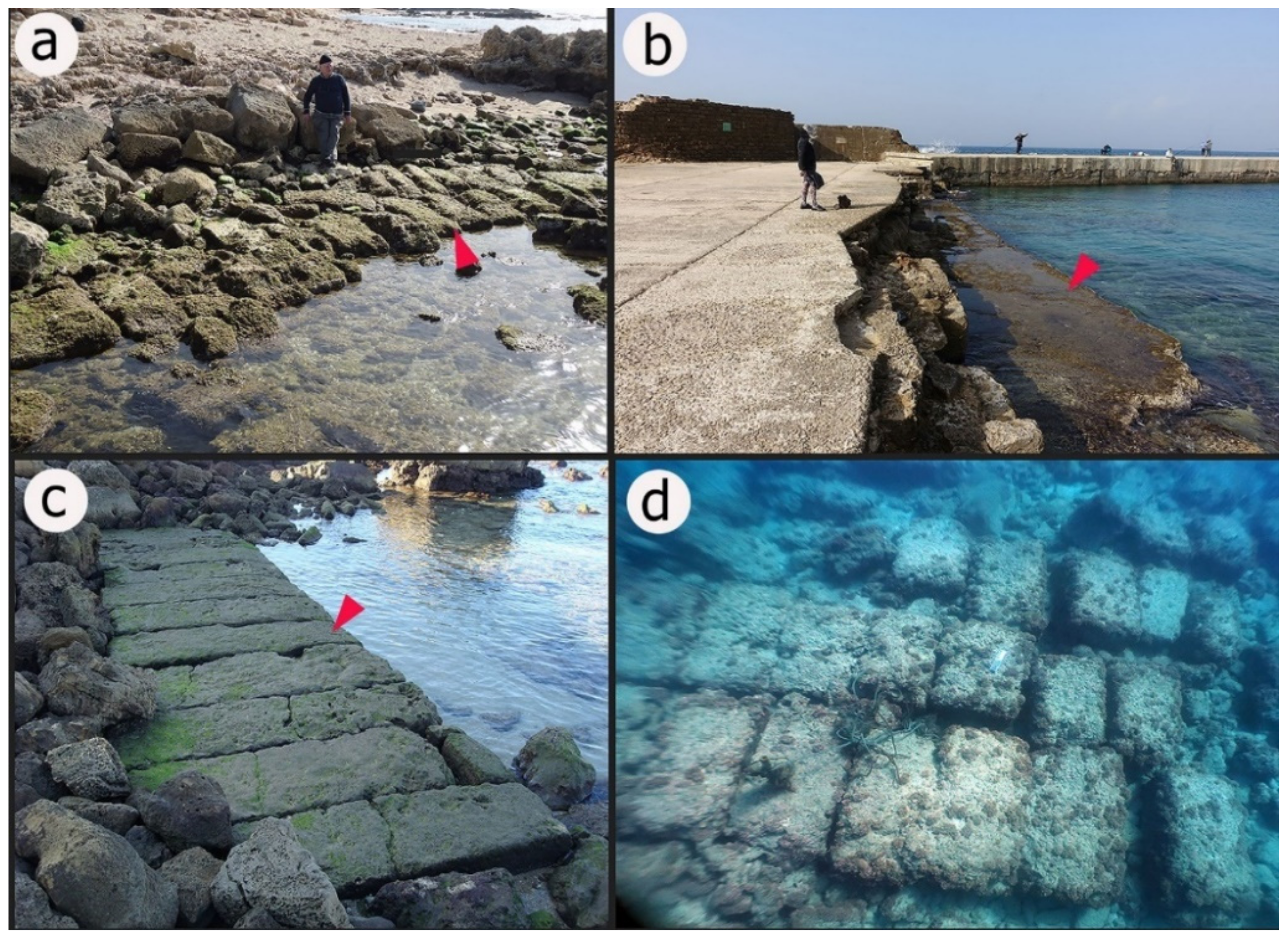
The archaeological features used as sea-level markers can be divided into several categories [12,15,28]: (1) Features that need to be at sea level or partially below sea level in order to function properly (e.g., Figure 3B,C). These include: pools fed by sea water driven by gravity (wash tanks), slipways, harbor installations that are partly submerged while functioning, salt production installations, coastal water wells, etc. These types of structure can mark the uppermost and lowermost sea levels at the time of construction; (2) Features that are located normally on dry land to enable functioning, including: dwellings, quarries, roads etc. (e.g., Figure 3A) These structures usually provide the uppermost sea level at the time of construction [12,25,36]; (3) Features that are expected to be at sea (shipwrecks) (Figure 3D) provide the lowermost possible sea level at the time of deposition. However, under certain circumstances, features of categories 2 and 3 may also provide the lowermost and the uppermost possible sea levels [13,29]. Discriminating sea-level changes from local earth-crust (tectonic or isostatic) changes can be done by comparing local sea-level curves with global sea-level curves or with curves retrieved from tectonically stable areas. Overall, the employment of installations cut into the rock rather than those built from stone or other materials on unconsolidated sediments should enable the elimination of the impact of erosion, settling and collapse.
2.3. Disagreements Resulting from Different Interpretations of Sea-Level Markers
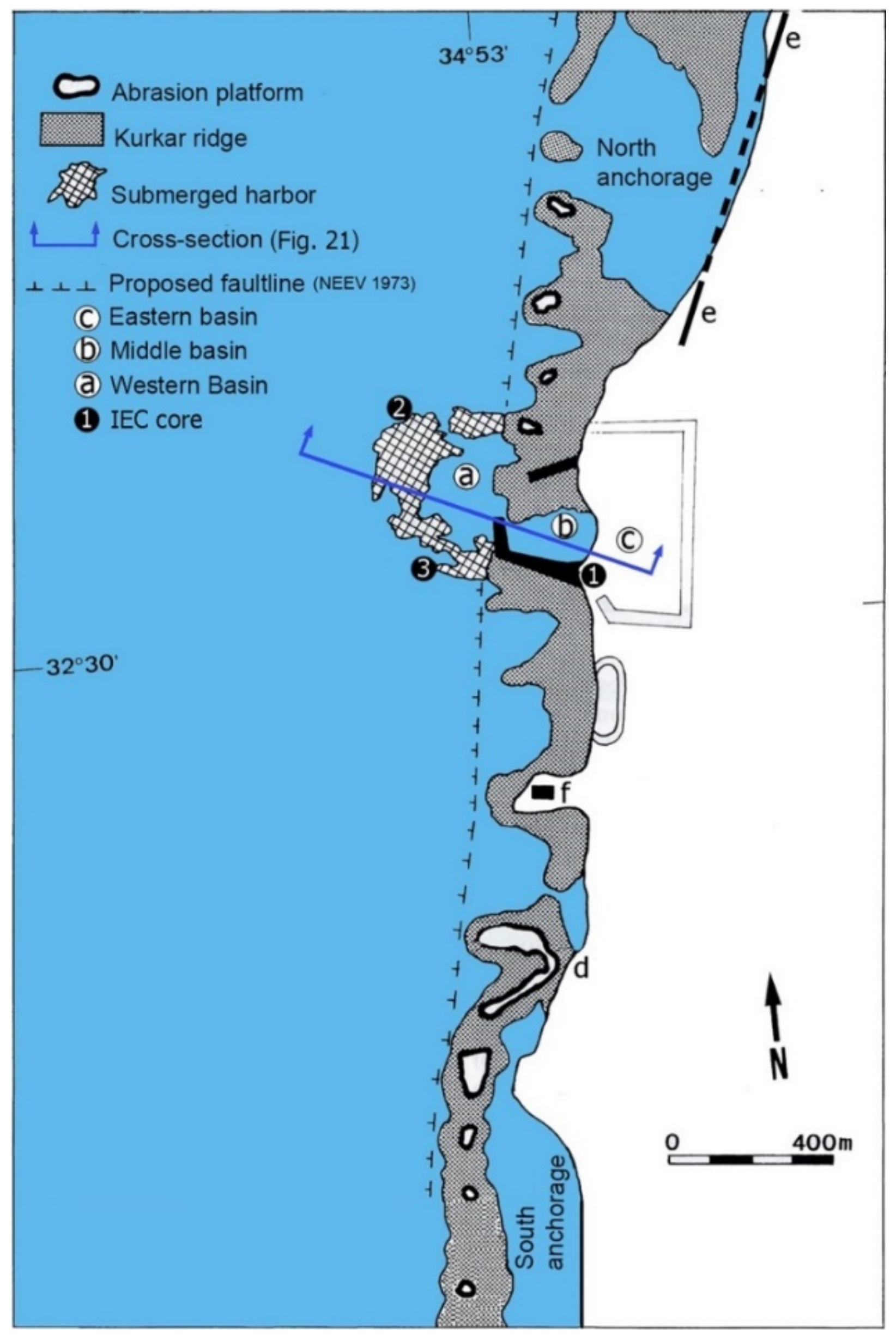
Using archaeological and natural features as indicators of sea-level and coastal changes should be done with care. One should be aware of the limitations of using these markers, considering their reliability and inaccuracies and the standard errors of the dating and measurements of the markers, while at the same time taking into account the various possible combinations and scenarios. Mistakes may lead to misinterpretations and cause disagreement between scholars. Here we examine the case of the Roman Harbor of Caesarea, Israel (Figure 1) and demonstrate the complexity of using controversial dating and the consequences of employing questionable identification of the function of archaeological and natural features.
3. The Case of the Roman Herodian Harbor of Caesarea
Underwater and coastal archaeological research carried out in Caesarea since the 1960s revealed the monumental ruins of this coastal city and its harbor and shed light on its past. However, the reasons for the destruction of the Herodian Harbor and its dating are still controversial and are not fully understood. The enigmatic cause of destruction of this harbor, one of the greatest marine constructions built in antiquity (Figure 4), attracted scholars for many years. It was suggested that the destruction was caused by tectonic subsidence associated with an earthquake [37,38,39,40] by settlement due to unconsolidated sediments [12,18,41] or by tsunamis that hit the harbor in 115 CE [42] and in the 6th century CE [8,9]. Here we reassess and discuss the suggested causes and nature of the destruction in light of the historical records, geological and archaeological studies of natural and man-made features associated with the harbor, and provide insights on the possible reasons for the demise of this ancient structure.
3.1. The Herodian Harbor at Caesarea
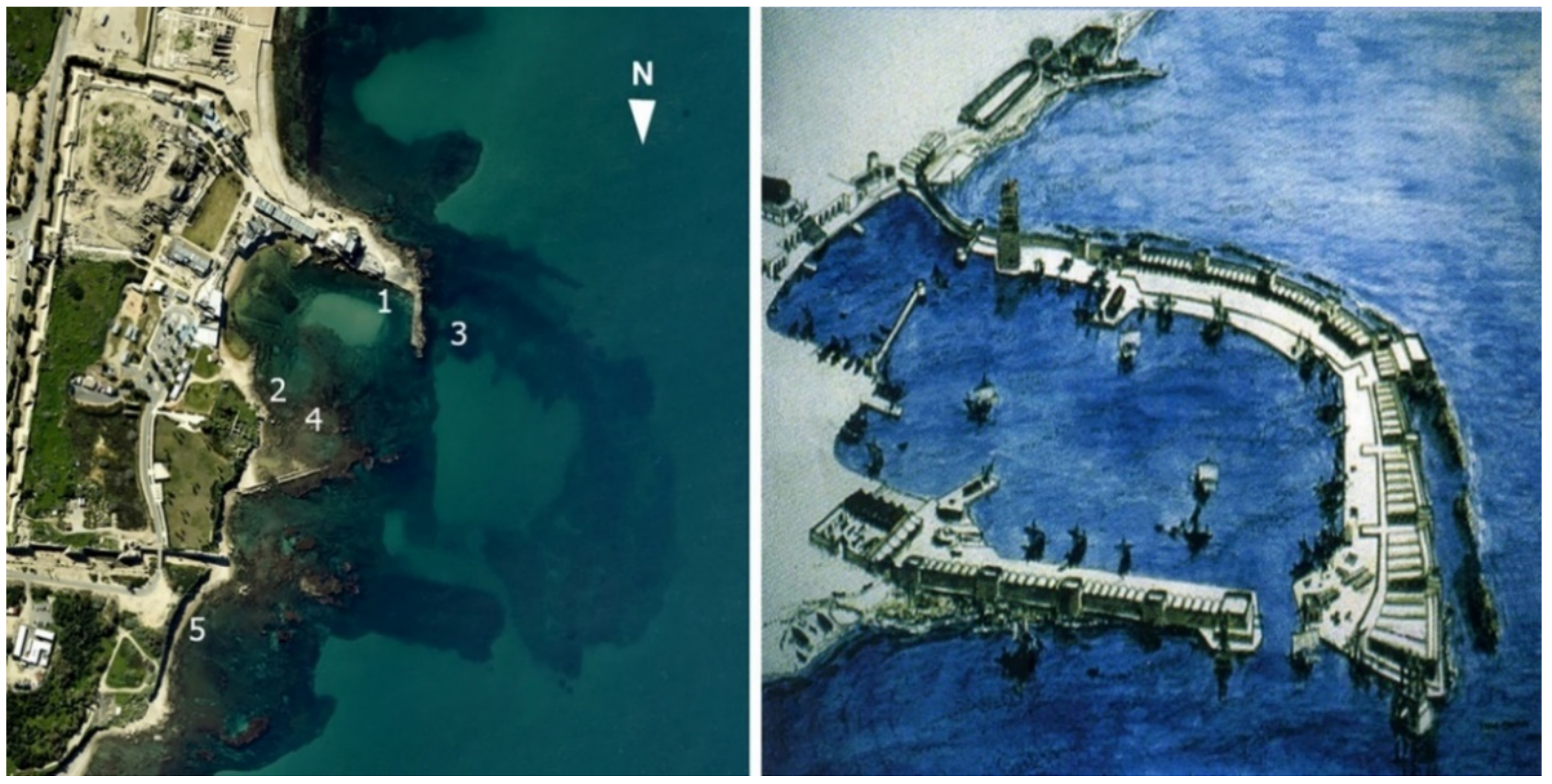
The Historian Flavius Josephus (ca. 37–100 CE), who lived after the construction of the harbor, stated “However, by dint of expenditure and enterprise, the king triumphed over nature and constructed a harbor larger than the Piraeus, including other deep roadsteads within its recesses” [44]. According to Josephus, Herod the king of Judea under Rome built the open-sea harbor Sebastos in Caesarea over the course of 11 years (21–10 BCE), using the best experts, technologies and materials available at that time. The harbor was named after Octavian, who took the title Augustus—Sebastos in Greek—in 27 BCE [44,45]. The first underwater excavations in this harbor were headed by A.D. Link in 1960. Between 1963–1972, excavations were conducted on behalf of the Underwater Exploration Society of Israel, headed by E. Linder. From 1975 to 2005, the harbor and the city were excavated and studied by the Institute of Maritime Studies at the University of Haifa, headed by A. Raban and by Y. Porat on behalf of the Israel Antiquities Authority.
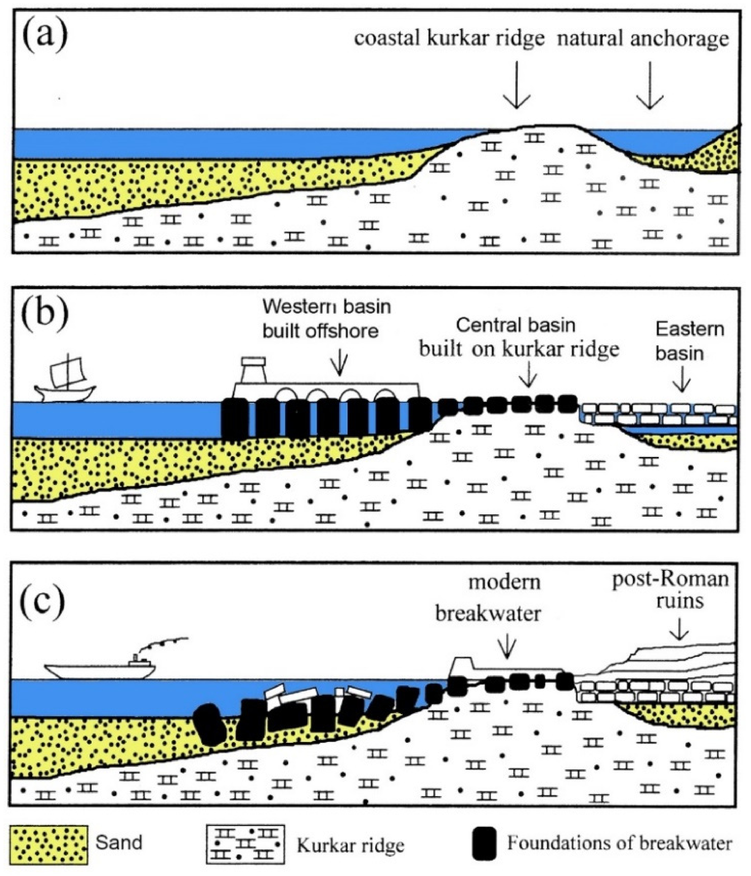
The ongoing research of the site revealed that the Herodian harbor complex consisted of three basins:
- (1)
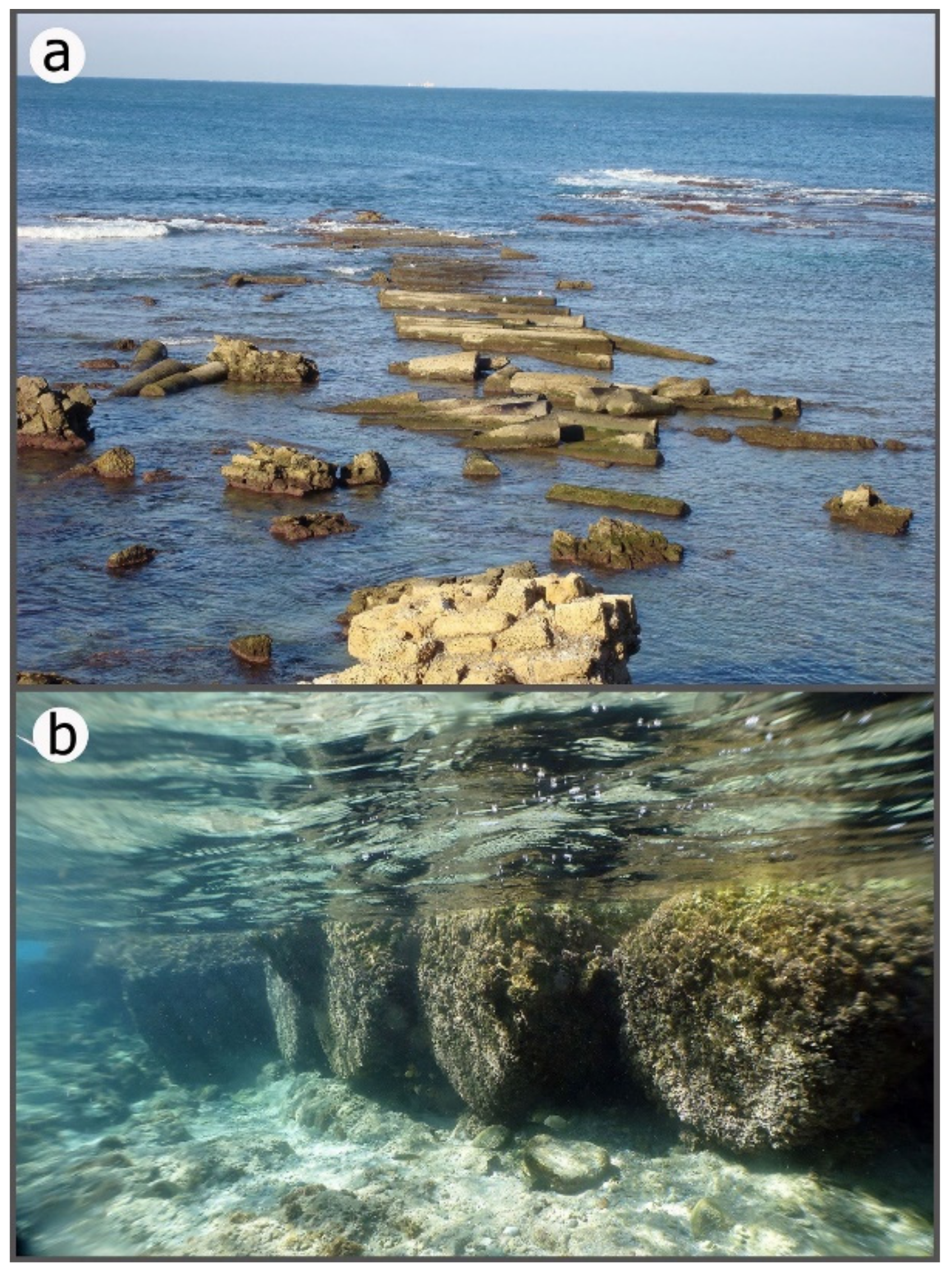
- The Western Basin (Figure 5a)—This basin is now submerged. Its outlines were initially located through aerial photographs (Figure 4: left). It was built in the open sea using local and imported building materials, mainly marine concrete. The concrete consisted of volcanic ash (pozzolana), crushed limestone and gravel, which were poured into floating wooden molds (caissons) that were then sunk into their intended position. The main piers of the western basin were built of kurkar (local calcareous-cemented sandstone of aeolian origin) ashlars laid on their narrow side (headers) and of huge (up to 12 m long) marine concrete blocks. The wide, main breakwater was built in the shape of the letter L, facing north. The shorter northern (i.e., lee) breakwater was built to the west, perpendicular to the coast, leaving a narrow opening in the harbor facing north-west.
- (2)
- The Middle Basin (Figure 5b)—This basin was built on a coastal kurkar ridge, utilizing a natural gap or a bay in it. In the northeastern and southern parts of this basin, a number of piers were discovered (see below). Flushing channels were also designed to flow into the high wave-heads that plagued the southern part of the port, and to convey them into the mooring pools in order to create excess water that flows out of the port. According to the excavators, this flow intended to reduce the penetration of sand into the harbor, thus preventing its clogging.
- (3)
- The Inner (Eastern) Basin (Figure 5c)—This basin is currently inland. It relied on a shallow marine feature on the lee side of a partly submerged coastal kurkar ridge. After the harbor went out of use, this basin was silted and later filled by mostly Early Islamic buildings [46]. Excavations in this basin revealed a built wharf and mooring facilities for ships [47,48].
3.2. Historical and Archaeological Evidence Indicating the Cessation of the Harbor Activity
Raban [48,49] summarized the historical and archaeological studies concerning the operation of the harbor and its dates of the cessation. During the early 6th Century CE, Procopius of Gaza wrote: “The harbor of the city named after Caesar (Portus Augusti) had disintegrated through age and lay open to every threat from the sea. Its structure no longer measured up to the category of harbor, but of its former condition it kept the name alone” (col. 2817, [50]). He also mentions that the Byzantine emperor Anastasius I (491–518 CE) provided resources to repair the harbor [51]. Thus, it seems reasonable to assume that by the 6th century CE the harbor was out of use.
Relying on numismatic evidence, Ringel [52] and Holfelder [53,54] suggested that the harbor was operational during the 3rd to 5th centuries CE. Based on the botanical remains of crop species collected in the eastern basin, Ramsy [55] suggested that maritime activity took place there in the 4th–6th century CE. A study of shipwreck remains on the breakwaters of the western basin [49] revealed a wreck with amphoras that were in use from the end of the 2nd century CE until to the end of the 3ed century CE. Thus, Raban [49] inferred that during the 3rd to 4th centuries CE the breakwaters were already partly ruined and the main breakwater had deteriorated, and proposed that the western basin of the harbor underwent tectonic subsidence.
Later studies reported on a cargo of lead ingots, which were found in area K, at the northern end of the main breakwater, and dated it to the years 83–96 CE according to inscriptions (p. 102 and Figures 47 and 48, [48,56]). The excavators assumed that the ingots originated from a ship wrecked on the breakwater, and suggested that this part of the port ceased to function about a hundred years after its construction [48,56].
3.3. Archaeological and Geological Evidence for Sea-Level and Coastal Changes/Stability in Caesarea
- (1)
- (2)
- Harbor wharves in the central basin—The wharves were built on the kurkar ridge and they retained their original level [41]: On the south-western side of this basin, a Roman quay was built of headers and it is presently at sea level (Figure 4(1) and Figure 7b). Another quay was excavated by Raban on the northeastern side of this basin and was dated to the Herodian period (p. 86 and Figure 22, p. 115 and Figure 6, [48]) (Figure 4(2) and Figure 7c). Both structures are currently at an elevation that enables functioning.
- (3)
- A surface built of large ashlars—The surface was discovered in the western basin at more than 5 m depth (Figure 4(3) and Figure 7d). This structure was interpreted as a submerged pavement, supposedly indicating that the west basin of the harbor underwent tectonic subsidence and could no longer function as a port (p. 96 and Figure 38a,b [48]; [56,57,58,59]). This surface, however, could have been originally built underwater (see below).
- (4)
- (5)
- (6)
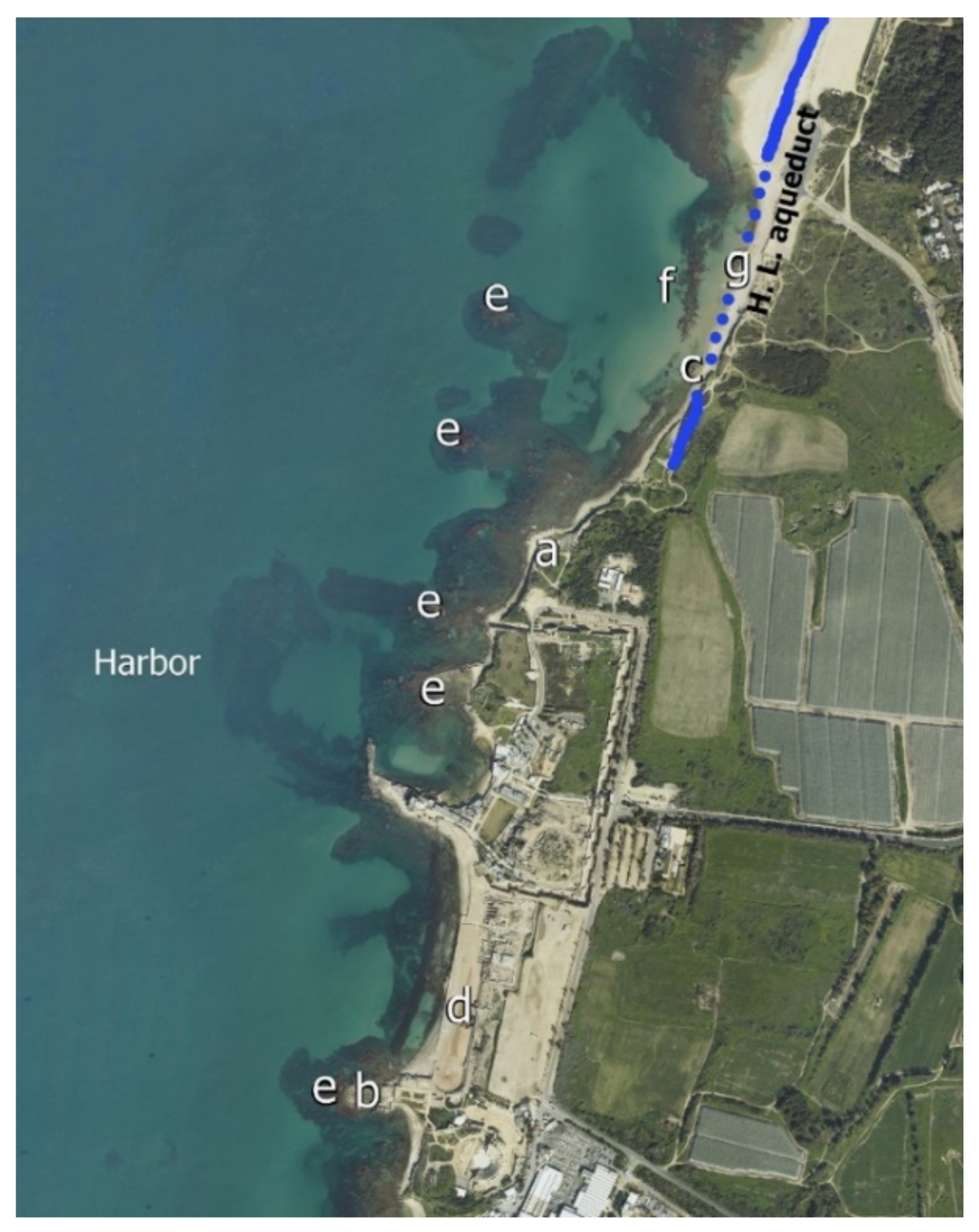
- Byzantine sewer outlet in the northern anchorage—The Byzantine sewer outlet has been ruined by the advancing sea (Figure 6c and Figure 9). The ruins of this stone-built structure are now scattered along the sea bed to a distance of 35 m offshore. Originally, this indicates the location of the Byzantine coastline at the time that the sewer was still operating, some 1500 years ago. Its present location suggests that the coastline has shifted eastwards since the Byzantine period (p. 20, [41]) (Figure 6c and Figure 9).
- (7)
- (8)
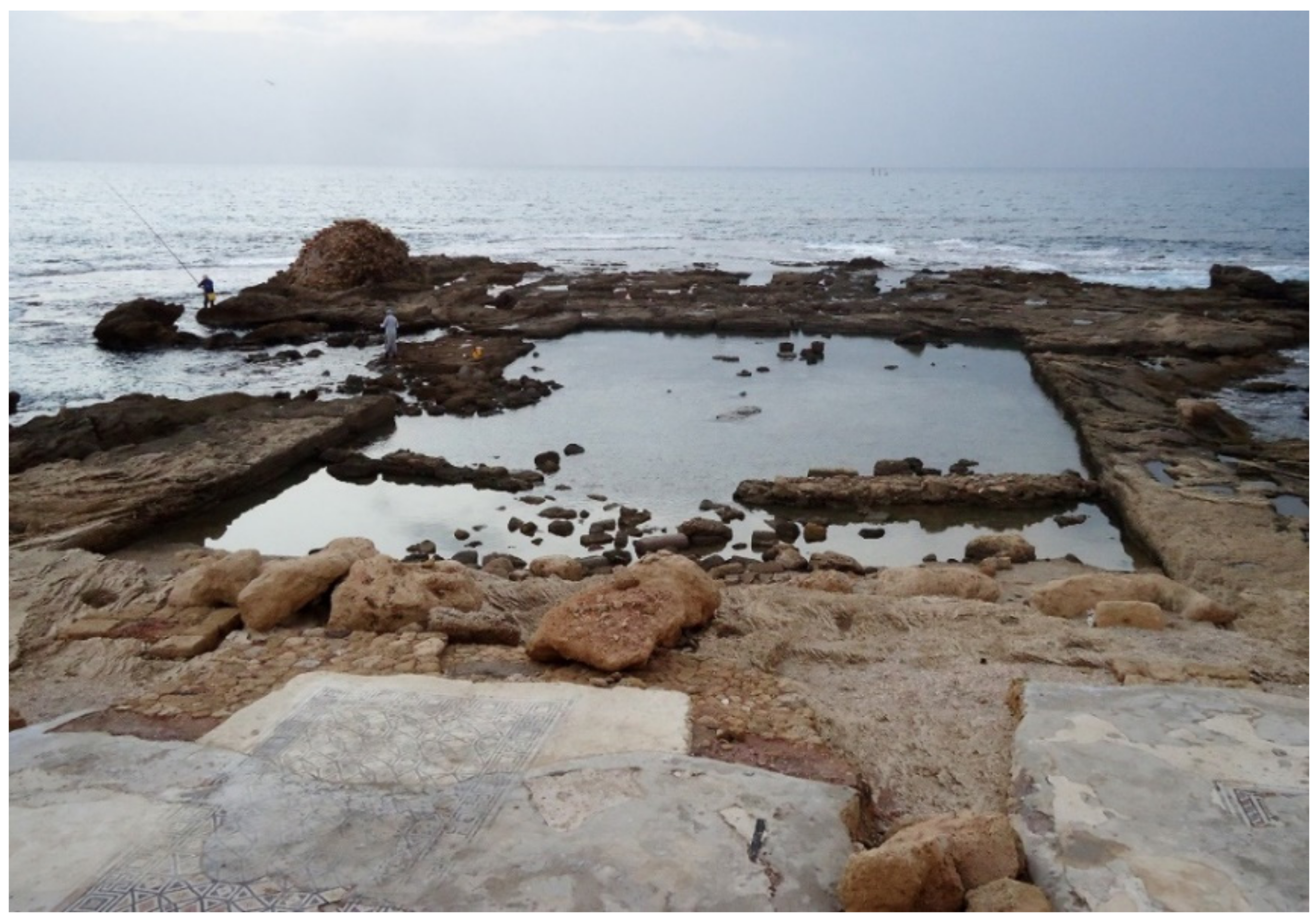
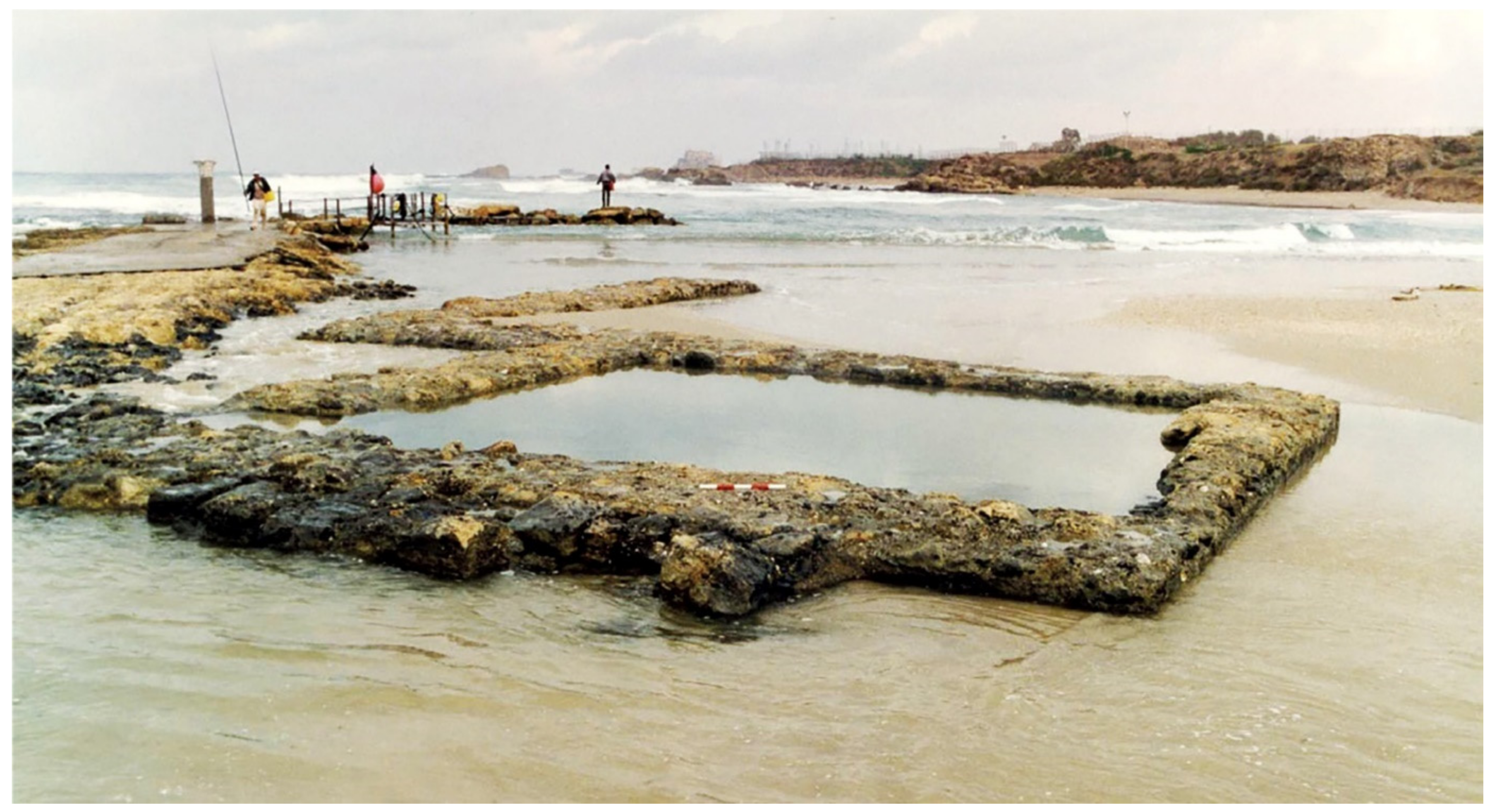
- Stone-built pool near Kibbutz Sedot-Yam—The rectangular stone-built pool that can be filled with sea water by gravity is currently at present sea level (Figure 6d and Figure 10). Given its building style and location (close to the southern Byzantine city wall), it can be dated to the Byzantine period. The structure could have served as a swimming pool.
- (9)
- (10)
- Abrasion platforms—North and south of the harbor, the coastal kurkar ridge was abraded by the sea and the abrasion platforms are at the same elevation as present sea levels (Figure 6e). The abrasion platforms and wave notches in Caesarea and along the entire Carmel coast suggest stable sea-level conditions over the last few thousand years, since sea levels reached their present elevation, ca. 4 ky ago [12,29].
- (11)
- (12)
- (13)
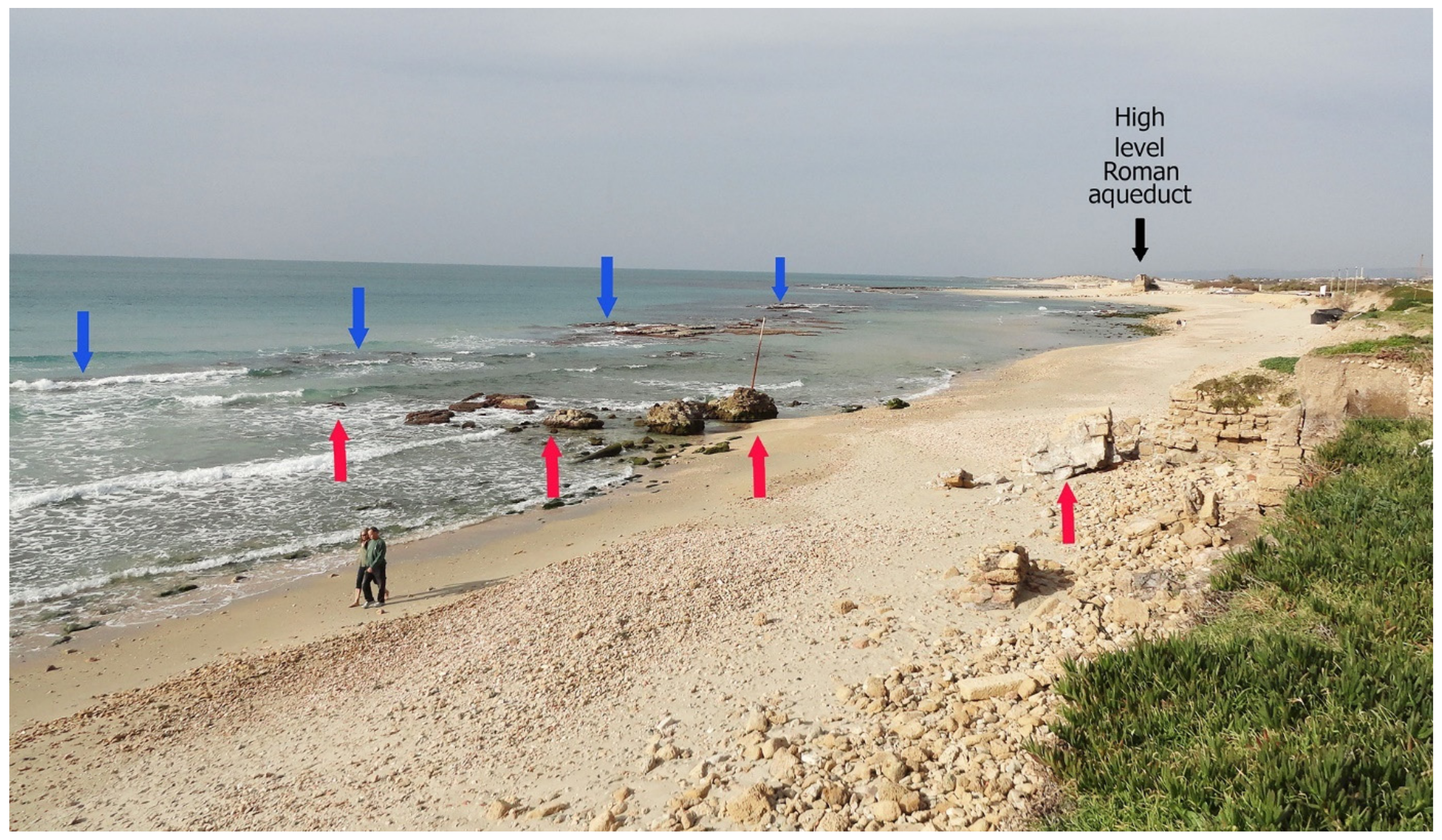
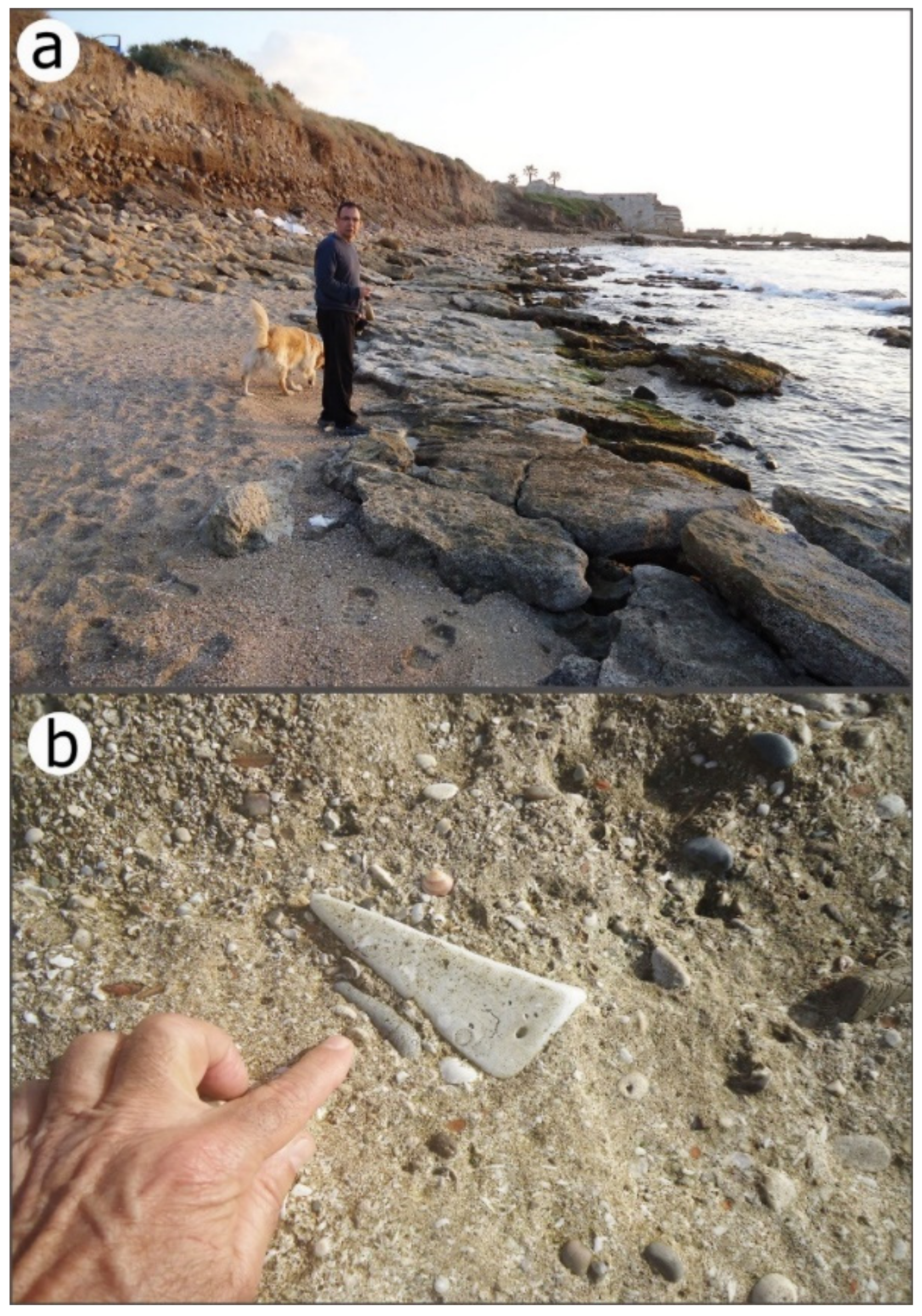
- Beach rock ridge in the northern anchorage (Figure 6f and Figure 9)—A massive strip of in-situ beach rock deposit, about 2.8 m-thick, is at 0.2–3.0 m below the present sea level. The deposit is located parallel to the coast, some 60 m west of the present shore and the remains of the aqueduct foundations (Figure 9 and Figure 6f). This beachrock probably marks the location of the ancient coastline before the construction of the harbor and the aqueduct, and indicates that the shoreline has retreated horizontally some 60 m eastwards since the construction of the Roman aqueduct. This coastline shift must have occurred under stable sea-level conditions (p. 20, [41]).
4. Discussion
4.1. Sea-Level and Tectonic Considerations
The tectonic stability and the sea-level changes in the Caesarea area during the last two thousand years, as well as the scenarios for the destruction of Caesarea harbor, are discussed below on the basis of the principles and observations summarized above and the reevaluation of previously published studies.
Overall, the archaeological and natural features in Caesarea suggest that the relative sea level has been stable at least since the Hellenistic Period. This is attested by the elevation of the Hellenistic and Roman wharves (Figure 6 and Figure 7b,c), the elevation of the abrasion platforms in the Caesarea region, the beachrock deposits north of the Crusader wall (Figure 12), the rock-cut and stone-built pools (Figure 8 and Figure 10), the water wells in the eastern basin and the oysters and the mooring stone on the eastern basin. All these features are at an elevation that enables functioning even today. The finds from Caesarea coincide with the analysis of archeological, geological and biological markers along the entire Israeli coast, that also indicates tectonic stability and stable sea levels during the last 2000 years [6,13,22,30,43].
Horizontal changes in the location of the coastline north of the harbor are attested by the present location of the beachrock ridge, currently some 60 m offshore, the flooded foundations of the high-level Roman aqueduct (Figure 13) and the outlet of the Byzantine sewer (Figure 9), as was explained above. Assuming that the beachrock ridge in the northern anchorage (Figure 9) designates the location of the coastline before the massive man-induced intervention in the marine environment (mainly the construction of the Roman harbor), the coastline in this place must have shifted some 60 m inland following the construction of the harbor. The exact duration and rate of the eastward shift of the coastline, however, is yet to be studied. In the eastern basin of the harbor, however, the coast has artificially shifted some 100 m seawards (to the west), following the cessation of the maritime functioning of this basin, and the post Byzantine urban building in this area. Thus, the horizontal shoreline migrations and the construction of the archaeological features in Caesarea, as well as the destruction of many of them, must have occurred under stable sea levels and tectonic conditions, at least since the Hellenistic period. This conclusion does not exclude, of course, possible minor sea-level changes less than the local tidal range.
4.2. The Time of Destruction of the Caesarea Harbor
Dey and Goodman-Tchernov [62] noted that the centuries of late antiquity in Caesarea harbor were understudied, partly because of the notion that the harbor was in decline by the 2nd century CE, or even earlier.
The numismatic and the historical evidence [52,53,54], as well as botanical remains from the eastern basin [55], suggest that the Caesarea Harbor functioned until the 5th century CE. Initial research of shipwrecks suggested that the western basin was partly ruined by the late 2nd or 3rd centuries CE [49]. A later shipwreck study [56] suggested that the breakwaters subsided and ceased to function ca 100 years after their construction. This suggestion relies on the cargo of lead ingots that was dated to post 84 CE, assuming that the whole western breakwater was underwater at that time. However, the ingots were discovered in area K, at the far northern end of the breakwater, south of a small artificial island close to the entrance of the harbor. It is still possible that only this small part of the breakwater was damaged, while all the rest of the main breakwater was functioning. Goodman-Tchernov and Austin [9] suggested that during the 1st and 2nd centuries CE, a tsunami caused damage to the artificial island near the harbor entrance and breached the tops of man-made features on the breakwaters; however, as seen in reference [8]: Figure 6 reflector B, the breakwaters remained intact. In contrast, the harbor’s structure was much degraded by the time of the 6th–8th century CE tsunamis (Figure 6 reflector A, [9]). The discrepancy between the assumed early destruction (100 years after the start of the harbor’s operation), and the late destruction, leaves the time of actual destruction yet to be determined.
4.3. Possible Destruction of the Western Basin due to Tectonic Faulting
Several arguments were presented to support the claim that the western basin of the Roman Harbor had undergone tectonic subsidence, which led to its destruction [37,40,42,56,58,63,64,65,66]): (1) The western basin features are currently submerged; (2) Shallow and high-resolution sub-bottom sonar survey, west of the modern harbor, revealed a sub-bottom north-south oriented step, west of the submerged kurkar ridge that crosses the Herodian Harbor [37,38] (Figure 5); (3) In boreholes located on land and at sea on both sides of the sub-bottom step (Figure 5: IEC 1–3), layers of pebbles were identified at different elevations. These findings led researchers to interpret the sub-bottom step as a tectonic fault that was active after the Roman period, and caused the subsidence of the western basin of the harbor, and consequently brought its operation to an end [38,39]. The Caesarea tectonic fault hypothesis was in line with the concept of an active fault that runs linearly, all along the Mediterranean shoreline of Israel. According to Neev et al. [37,63], this fault uplifted the land east of the coast, creating the Sharon escarpment and a coastal cliff, and subsided the sea to the west.
An active fault along the coastline of Israel, if it exists, poses high seismic risk for the crowded population and infrastructure facilities in the region. It therefore attracted much attention and interest in the scientific community and applied research communities, regarding both the analysis of historical events as well as a risk assessment in order to mitigate the potential impact of possible future earthquakes. It is worth noting the detailed geotechnical examination of the site proposed for the construction of a power station, around 15 km southwest of Ashdod [67]. Studies have analyzed the supposed evidence for Late Pleistocene to Holocene faulting, and found no support for its existence [68,69,70]. Furthermore, no surface faults were marked in and around Caesarea on the geological map of Israel [71], and we do not know or suspect any active fault [72].
Thus, the vertical step that was interpreted as an active fault should be approached as nothing more than the western margins of the local submerged kurkar ridge covered by sand. Moreover, the Late Pleistocene kurkar, either “Dor” or “Ramat-Gan” formations, was lithified tens of thousands of years ago [73]. Another sign proposed as evidence of tectonic subsidence is the paved surface, presently situated at 5 m water depth below sea level (see above). Josephus described structures originally built at several fathoms (1 fathom = 1.83 m) on the sea floor at Caesarea. Therefore, the ‘sunken’ paving could have been originally built on the sea bed. The pebble units found at different elevations in cores in the harbor area [37], if correlative, could have been deposited originally on an inclined slope rather than being offset by a fault. Overall, the tectonic stability of the Caesarea coast is evident from man-made installations and natural features, as were described above, as well as from similar features from the entire Carmel coast [12,41,74].
4.4. Possible Destruction of the Harbor by Earthquakes
During the eighties and nineties of the 20th century, a favored interpretation for the destruction of the harbor was a catastrophic seismic event [37,49,63]. It was suggested that the western basin of the harbor subsided rapidly due to an earthquake associated with the assumed fault mentioned above, which occurred between the end of the 1st and the beginning of the 2nd centuries CE. Reinhardt and Raban [40] accepted the above theory, and partly adopted the settlement scenario proposed by Galili and Sharvit [12]. Reinhardt and Raban [40] stated that the breakwater may have sunk due to liquefaction (a seismogenic ground failure, in which a shallow saturated granular material loses its strength, behaves like a liquid and can no longer support constructions built on it) that may have resulted in an earthquake, or perhaps even from undercutting and scouring by currents generated by large-scale storms or even tsunami waves.
In his book Antiquities [75], Josephus mentioned that during 31 BCE, an earthquake affected Judea (p. 774, [76]). However, there is no specific mention of any damage in Starton’s Tower (Hellenistic Caesarea). Nevertheless, Karcz [76] concluded that the textual evidence reflects a relatively modest earthquake rather than a major catastrophic event. Contemporaneous records report on several earthquakes that occurred in the Levant at the time of the Herodian Harbor, but only two of them were reported to have damaged Caesarea. It was alleged that the earthquake of 127–130 CE destroyed Caesarea and Nikopolis (Emmaus) (p. 234, [77]), though Karcz (p. 32, [78]) notes that the historic source may have referred to Nikopolis and Neocaesarea in the Pontus (Turkey). The account of the earthquake of 18th and 19th of May 363 CE reports that part of the city of Caesarea was destroyed (p. 264, [77]), [79]. This date is ca. 250 years later than the time proposed for the 115 CE destruction of the harbor. Indeed, Caesarea may have been hit by an earthquake during the early first millennium CE, but the archeological and the historical records do not unequivocally mention a destruction of the harbor by an earthquake. The 2nd century BCE earthquake that struck Antiochia was believed to have generated a tsunami that impacted Caesarea (see below).
4.5. Possible Destruction of the Herodian Harbor by Tsunami Events
Sedimentological and archeological studies carried out in the harbor and in the open sea west of it has led to the suggestion that the harbor was destroyed by a tsunami that would have struck Caesarea after the Antiochia earthquake of December 13, 115 CE [42]. Another study by Dey and Goodman-Tchernov [62] suggested that two tsunamis hit Caesarea and caused damage to the harbor: the above-mentioned 115 CE tsunami would have occurred some 20 years before the Bar Kokhba Revolt, “which perhaps helps to explain why the authorities in Rome made no efforts to restore the harbor”. The second one was the mid-6th century CE (551 CE) tsunami of unusual power, “this tsunami, which impressed ancient chronicles, did cause a great deal of damage, from which the harbor and perhaps the city, as a whole, have never recovered”. Another Bronze Age tsunami associated with the Santorini event (long before the construction of the harbor) was identified in core samples taken offshore of Caesarea by Goodman-Chernov et al. [80].
A later study of Goodman-Tchernov and Austin [9] included sub-bottom sonar profile mapping and coring west of the harbor of Caesarea, at a depth of 14–20 m. They identified three sub-bottom reflectors, representing strata which were interpreted as marks of tsunami events. They also identified pronounced, sub-bottom channels in association with the ancient harbor, which they attributed to the tsunami backwash currents. Judging by the location of the sub-bottom channels, they concluded that the 1st to 2nd century CE tsunami caused damage to the harbor, but the breakwaters remained intact (see above). This conclusion changes previous notions which suggested that the 2nd century tsunami was responsible for the rapid destruction of the harbor [42]. Goodman-Tchernov and Austin [9] also concluded that the harbor’s appearance was much degraded by the time of the 6th–8th century CE tsunamis. Here we discuss in detail the findings used by these researchers to support the hypothesis whereby it was destructive tsunamis that destroyed the Herodian harbor.
4.5.1. Archaeological Finds Presented as Evidence for a 2nd Century CE Tsunami Event
Mixed layers of sediment, described as garbage, were found in material excavated from the harbor. The excavations yielded some valuable artefacts, such as bronze figurines, and it has been argued that the supposed garbage is actually a mixture of marine and terrestrial sediment left behind by tsunami waves [42]. However, in ancient anchorages and harbors, along the shores of Israel and beyond, the remains of numerous vessels and cargoes of ancient ships were discovered, including bronze statues and valuables (e.g., in Akko harbor, [81]). Many ships have been wrecked in the Caesarea area over the years, as evidenced by numerous finds discovered in the harbor and nearby anchorages [41], (pp. 75–112, [48]), [59,82]. It is therefore more likely that the origins of the valuable artefacts discovered within the sediments in the port originated from ships that were wrecked in and around the harbor during storms, or they were objects that fell into the water during loading or unloading of the cargo. Such finds, common in ancient harbors, may not be interpreted as unequivocal evidence of a tsunami event.
4.5.2. Sedimentological Findings at Sea Presented as Indicators of a Tsunami
The core issue in tsunami sedimentology is to distinguish tsunami deposits from beach or storm deposits. Marine fauna and marine deposits found in low-lying, lagoonal water bodies near the coast are often used as paleo tsunami indicators, and so is the presence of large boulders on a rocky coast, away from the sea [42,83,84]. Identifying offshore tsunami deposits is more challenging. It has been less practiced, as there are very few analogies for comparison and it is hard to distinguish them from storm deposits [10,42,83]. A comprehensive study conducted by Mariner et al. [84] analyzed hundreds of published records of tsunami events in the Mediterranean and proposed that 90% of them are problematic and need to be re-examined.
4.5.3. Outside the Harbor
At a water depth of 10–12 m offshore, Reinhardt et al. (area W, [42]) identified beds of small angular shell fragments and potsherds dated from the 1st century BCE to the 1st century CE that were overlain by a layer of convex-up-oriented disarticulated bivalve shells. Relying on the fragmentation patterns and stratigraphy of the shells, the authors assumed that these shells could be related to the 115 CE tsunami deposits. Reinhardt et al. [42] also reported on the presence of articulated Glycymeris shells in the tsunami deposit, and suggested that these shells indicate transport from the deeper shelf, as the shallowest habitation depth for these bivalves is 18 m. However, no evidence for the presence of such articulated Glycymeris shells in the discussed deposits have ever been presented or published. Furthermore, Meinis et al. [85] noted that Glycymeris sp. (especially G. insubrica or violescens) were very common along the Israeli coast over long periods. They existed at different depths in a coastal environment (e.g., 8–16 m depth) and even at 200 m water depth. In the Adriatic Sea, their habitat was reported to be at a water depth of 2–40 m [86]. Moreover, Reinhardt et al. [42] give no explanation of how these articulated mollusks survived what they describe as the “…intense wave turbulence, shell-to-shell impacts, and shells striking the harbor moles or bedrock under high wave energy, as generated by a tsunami”. Given the above, there is nothing special in finding G. insubrica in sea bed sediments which are shallower than 18 m. The existence of articulated Glycymeris bivalves in the discased Caesarea deposits is yet to be proven, while the preservation of such articulated shells under a catastrophic tsunami that was assumed to destroy the Roman Harbor, is still to be explained.
As noted above, it is difficult to distinguish between tsunami and storm deposits [83,84,87,88]. Sakuna et al. [89] noted the difficulty in identifying the shallow-marine tsunami deposits associated with the 2004 Indian Ocean tsunami based on sedimentological evidence. Tamura et al. [10], who study the 2011 tsunami in Japan, concluded that this tsunami (“one of the largest modern tsunamis in the last 1200 years”) did not produce distinct sedimentary records in Sendai Bay. He also stated that there are no established unequivocal criteria for identifying shallow marine tsunami deposits and that it is impossible to identify the associated deposits at sea, since they are not preserved and might have been mixed by storms [10]. Their results agree with the suggestions of Weiss and Bahlburg [90] that the offshore tsunami deposits are unlikely to be preserved at depths shallower than 65 m. In this regard, the deposits identified by Reinhardt et al. [42] as the result of the 115 tsunami that is supposed to have destroyed the harbor, are questionable, as are the three reflected sub-bottom layers identified by Goodman-Tchernov and Austin [9] as tsunami features.
4.5.4. Tsunami Deposits in the Eastern (Inner) Basin
Excavations in the eastern basin [40] yielded a thin layer of sediments from the 1st to 2nd centuries CE, overlain by a deposit of mixed sediments. They determined that in the 1st century, and evidently up to the 3rd century CE, the prevailing conditions in the eastern basin were of a brackish body of water with good circulation. Thus, the inner harbor seems to have been in use after 115 CE. The mixed sediment deposits discovered in the eastern basin was attributed by Reinhardt and Raban [40] to cleaning and deepening of the harbor in early periods. The proposed main mechanisms for the destruction of the harbor in the study by Reinhardt and Raban [40] were the seismic and tectonic scenarios. Later, however, after reassessing the finds in light of the available new studies on tsunamis, the tectonic and seismic scenarios, as well as the dredging deposit hypothesis, gave way to the 115 CE tsunami scenario [42].
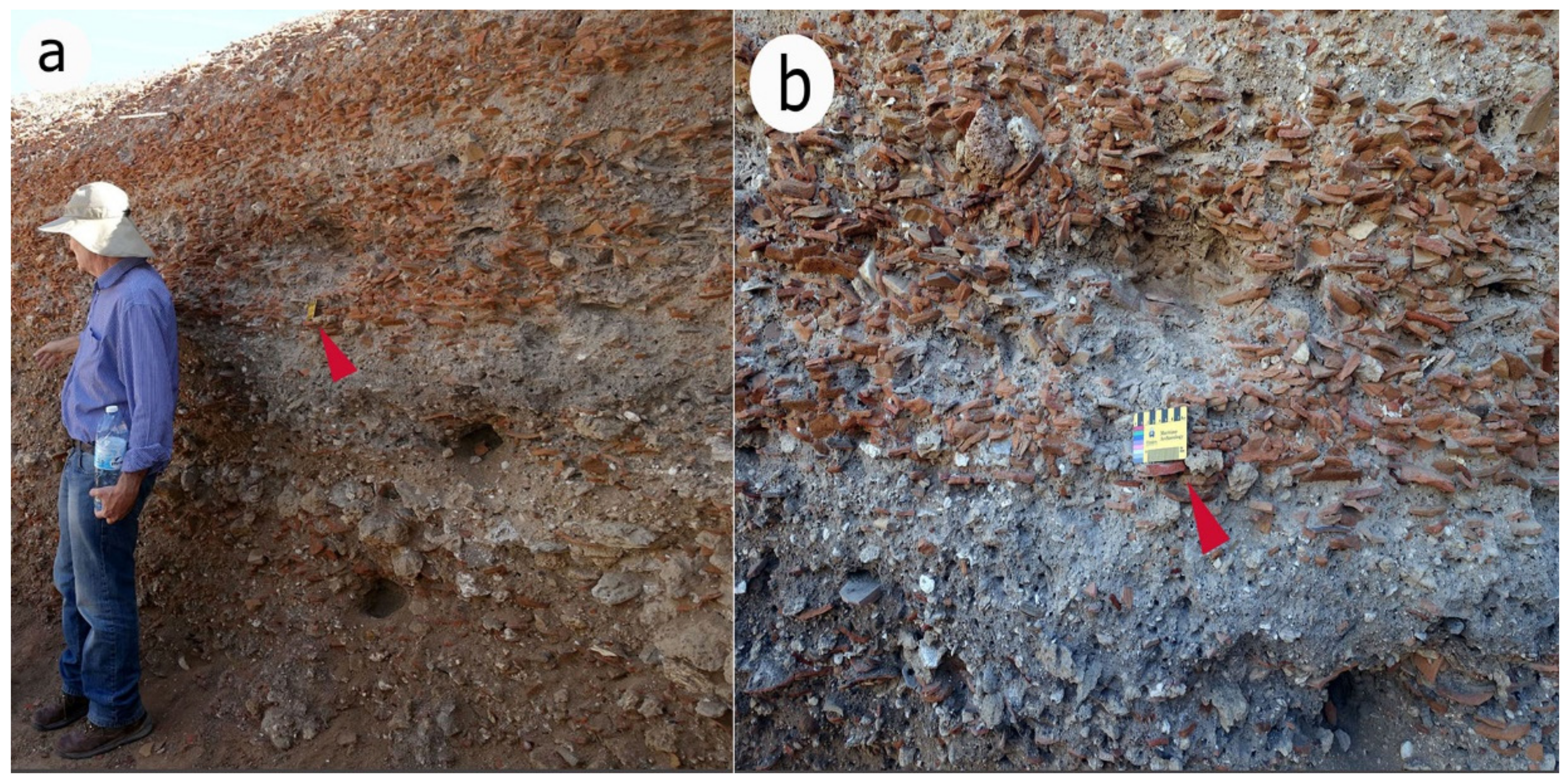
4.5.5. Tsunami Deposits on Land in Caesarea
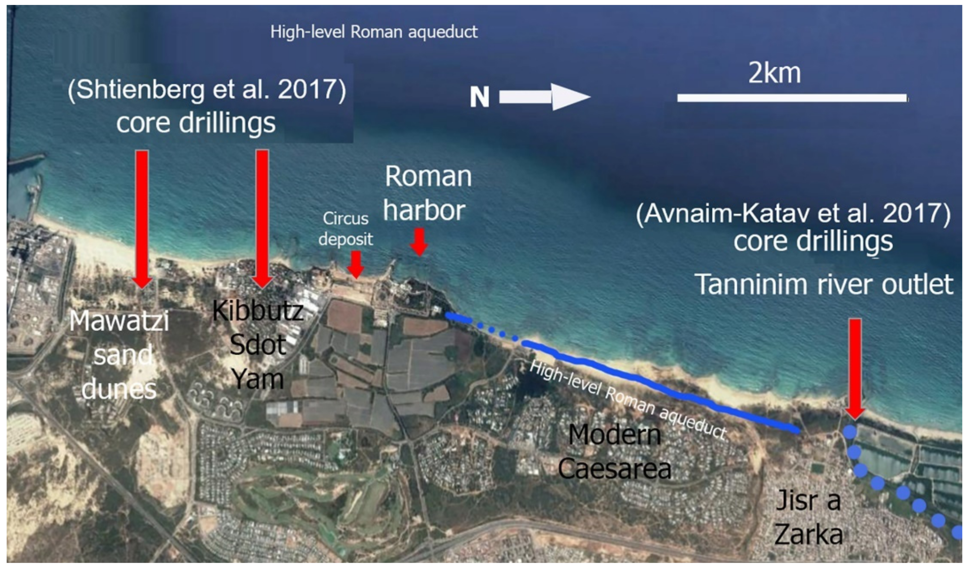
It is reasonable to assume that a powerful tsunami, such as the one suggested to have occurred in 115 CE, should have affected other places along the Caesarea region and leave behind tsunamigenic deposits that can be traced on land in Caesarea and surrounding lowlands. Excavations carried out on the coast of Caesarea yielded deposits which were associated with 6th and 8th century CE tsunami events (Figure 14) [8,9]. However, so far, no tsunami deposits that can be attributed to the second century CE were reported from land excavations in Caesarea and around. Furthermore, boreholes taken in lowlands a few km north and south of Caesarea [91,92] (Figure 15) revealed no tsunami deposits that can be dated to 115 CE. Nonetheless, no evidence does not mean no event, and further searches for possible 115 CE tsunamigenic deposits on land is certainly needed.
4.5.6. Historical Reports of Tsunamis in the Region
There are a number of historical reports of sea floods and retreats that have caused damage to coastal cities and harbors in the eastern Mediterranean. These events have usually followed local destructive earthquakes, and it is reasonable to assume that such descriptions relate to tsunamis [93] and references therein. In distinct cases, the descriptions leave no room for doubt, as should be expected from Mediterranean societies strongly attached to the sea and reliant upon it. Depictions of waves of all sorts abound in the sources of the classical tradition since its inception, and obviously also pervade the metaphorical sphere.
Typically, it is Thucydides, writing in the 5th century BCE, who offers a sharp and correct scientific analysis, ascribing the occurrence of tsunamis to earthquakes, and supplies an elaborate description of cities inundated by tsunami waves and partly or wholly destroyed as a result (Thuc. 3.89; see also Strab. 1.3.9; Strab. 8.7.1). Importantly, we see future generations relating back to such ancient reports, not only through literary references, but also through physical knowledge of relevant sites. The example of Helike in the northern Peloponnese is a case in point. Destroyed by a tsunami in 373 BCE, it is mentioned and visited by later travelers, such as Eratosthenes in the 3rd century BCE (in Strab. 8.7.2). The site and its submerged relics were still well known and frequently visited by travelers during the Roman period, and Pausanias’ report demonstrates that neither the cause of the destruction nor its scientific explanation were forgotten in the 2nd century CE (Paus. 7.24.12). Interestingly, the same place witnessed a similar event in the year 1817, when a tsunami wave caused by an earthquake flooded the entire plain, inundating the city of Vostitza, and destroying artillery depots which stood in the area (p. 402, [94]).
Naturally, knowledge of such events was available in antiquity also for the coasts of the southern Levant, as demonstrated in detail in the report offered by Strabo for the period preceding the building of Caesarea (Strab. 16.2.26): “An incredible phenomenon is reported to have taken place on the shore between Tyre and Ptolemaïs. The people of Ptolemaïs had engaged in battle with Sarpedon the general, and after a significant defeat were left in this place, when a wave from the sea, like a flood tide, submerged the fugitives; some were carried out to sea and drowned, while others perished in hollow places; then again, following this wave, the ebb uncovered the shore again and displayed to sight the bodies lying in confusion among dead fish. Similar occurrences take place at Mount Casius in Egypt. The ground undergoes a violent and single shock, at once exchanging places to a higher or lower level; the elevated parts oppose the access of the sea, and parts which had subsided admit it”.
Reports are available also for later periods. The tsunami that hit Akko and the Nile Delta after the earthquake of 25 November 1759 [93] in southern Lebanon may have reached Caesarea as well, even though Caesarea was not explicitly mentioned. Other historic tsunamis were also documented in the Levantine coast, such as the 1303 CE event that originated east of Crete and severely affected the port of Akko, 50 km north of Caesarea [95]. In the 20th century, after the strong July 1956 earthquake in the Aegean Sea, a weak tsunami was recorded in Jaffa harbor [96] and may have been noticed at the Haifa coast [97], just 30 km north of Caesarea [98]. These records demonstrate that tsunamis generated either by a near or distant source can reach the Levantine coast and threaten settlements, including Caesarea. Indeed, there are some reports of tsunamis that occurred during the 1st to 2nd centuries BCE: a) between Akko and Tyre (southern Lebanon) in the middle of the 2nd century BCE, as described above; and b) between Alexandria and Pelusium in northern Sinai, at the end of the 1st century (23 ± 3) BCE, but these occurred prior to the establishment of Caesarea, and are obviously not mentioned in the relevant reports [77,99].
The Babylonian Talmud (Baba Metzia 59: 72) says that Rabban Gamliel who lived in Yavne between the years 73–136 CE, sailed on a ship, and “nahshol she-bayam” (in Hebrew: a giant wave in the sea) was about to drown him. Based on this Talmudic source, Shalem [97] proposed that the mentioned swell in the sea indicates a tsunami that was induced by the 115 earthquake that took place along the northwestern coast of Syria. Shalem [97] noted that this earthquake brought about the destruction of Antiochia and the seismic waves spread far in the Mediterranean area, reaching as far as Rome [100]. According to Reinhard et al. [42], Dey et al. [8] and Goodman-Tchernov and Austin [9], this Talmudic evidence relates to the 115 CE Antiochia earthquake-associated tsunami, and would have been responsible for the partial damage or destruction of the Caesarea harbor. Examination of the Talmudic sources cited by Shalem [97] and the contemporaneous descriptions of the 115 earthquake shows that there is neither explicit mention of a tsunami, nor a report on where and when it hit (p. 31, [78] (D. Amit, pers. comm. 2006). The wave mentioned by Rabban Gamliel could have been any wave induced by a storm at sea. In fact, references to giant waves abound in the Talmud, and a brief scan of this rich corpus demonstrates that such mentions are mostly included either for producing rules and regulations for a maritime society accustomed to sailing (e.g., Bava Kamma 116b:7), or for setting a fantastic natural scene in order to deliver a message of faith or wisdom which has no intention or need to remain loyal to historical events (e.g., Yoma 38a:2).
Numerous historical sources written by various historians and authors have described the events that took place in the Holy Land during the first centuries CE (e.g., Tacitus, Hegesippus, The New Testament, the Jerusalem and the Babylon Talmuds). Given the awareness shown above by Mediterranean societies to distinct events of tsunami waves and the destruction caused by them, it is reasonable to assume that a total catastrophic destruction of Caesarea harbor, a crucial Roman facility, would have been mentioned in some of the chronical and historical sources of the time. Yet, as far as we know, there is no contemporaneous historical evidence for a destructive tsunami that hit the Levant coast in 115 CE or later and destroyed the harbor of Caesarea.
4.6. Swell Storms
The winter wave climate along the Mediterranean coast of Israel is characterized by alternating periods of calm seas and storm events [23,101,102,103]. Since November 1993, high-quality directional wave data have been measured simultaneously offshore Ashdod and Haifa (75 km south of Caesarea, and 37 north of Caesarea respectively) by the Coastal and Marine Engineering Research Institute. At these sites, where the water depth is about 24 m, a Wave-rider buoy was deployed to acquire 30-min records of surface elevation and directional spectral information [104]. By using the Weibull distribution with a 3.7 m significant height (Hs) threshold, a statistical analysis of extreme wave events was recorded in Ashdod during the period of 1 April 1992 and 31 March 2015. The analysis shows that the significant wave height for the 20, 50 and 100-year return period are about 7.07 m, 7.75 m, 8.27 m and 8.78 m respectively [105], with a maximum height of over 13 m [23]. Furthermore, during the last 20 years, four major storms with Hs > 7 m were measured in Haifa in Feb 2001, Dec 2002, Dec 2010 and Feb 2015. The statistical analysis, as well as the last major events, show that the Israeli coast is affected by relatively high waves [106]. These storms also induced strong longshore currents that may exceed 2 m/sec [23,103,107]. Here we discuss the potential impact of those winter storms and longshore currents.
4.6.1. Wave-Induced Seabed Liquefaction
Deposits of man-made artifacts originating from shipwrecks, shells and other natural products can be sorted and stratified below the sandy seabed in various depths by storm waves. Wave-induced seabed liquefaction of the sandy sea bed occurs at depths of up to 30 m below sea level to a depth of 3 m below seabed due to wave storms (pp. 445–509, [108]; E. Kit pers. comm. 2021). The wave-induced seabed liquefaction is maximal at water depths of 8–9 m [108]. Such liquefaction results in settlement and re-solidification [109], and may lead to sorting and stratification of artifacts and other natural products in sub-bottom horizons. Thus, the three sub-bottom horizons reported by Goodman-Tchernov and Austin [9], should also be considered as a result of wave storms effects.
4.6.2. Scouring
Fredsøe and Sumer (pp. 5–6, [108]) noted that “when a structure is placed in a marine environment, the presence of the structure will change the flow pattern in its immediate neighborhood, resulting in several phenomena: (1) the generation of turbulence; (2) the occurrence of reflection and diffraction waves; (3) the occurrence of wave breaking; (4) the pressure differentials in the soil that may produce “quick” condition/liquefaction allowing material to be carried off by currents. These changes usually cause an increase in the local sediment transport capacity and thus lead to scouring (erosion), which poses a threat to the stability of the structure”. The repeating strong waves and the currents eroding the sandy seabed on which wave breakwaters are built on cause these constructions to disintegrate and settle into the loose sand. It is thus more reasonable to assume that the breakwaters of the western basin of Caesarea Harbor underwent settlement and destruction mainly due to extreme wave storms. The structures most probably settled down because the sand they were based on was liquefied and scoured away by the winter storms pounding waves and currents. Nonetheless, rare and random earthquake and tsunami events may have also contributed to the settlement of the breakwaters and the destruction of the harbor.
4.7. Possible Cause of the Destruction of the Harbor
The evidence of earthquake or tsunami-driven damage to the Caesarea Herodian harbor, allegedly generating the disintegration and subsidence of the outer breakwater, is equivocal and far from conclusive. There is no supporting evidence for the assumed active fault that would have bisected the breakwater, nor is there any reliable historical account of such a destruction. The archaeological and sedimentological evidence proposed for indicating tsunamigenic events is more easily explained in alternative ways, as shown above. Indeed, one cannot rule out the potential contribution of seismic-driven sand liquefaction, or of tsunami-driven drift of sand beneath the breakwaters, to the disintegration and sinking of the breakwater. However, such events are rare and there is no conclusive evidence for their occurrence during the timeframe relevant to the deterioration of Sebastos, whereas the frequent winter storms, which have been pounding the harbor annually, offer a far more plausible cause for the destruction of the harbor [41].
5. Conclusions
The archaeological and geomorphological suite of evidence indicates that the relative sea level along the Caesarea coastline has been stable over the last 2000 years. There is no conclusive archaeological, historical or geological evidence for a destructive earthquake that damaged the Caesarea Harbor and no active faults are known to exist across the Caesarea harbor. Thus, the destruction of the western basin of the harbor could not be the result of a catastrophic event associated with tectonic subsidence, faulting or seismic events.
Similarly, no unequivocal archaeological or geological evidence has been found on land or at sea for the destruction of the harbor by catastrophic tsunamis. Furthermore, there is no reliable historical report describing a tsunami event that would have caused the destruction of the harbor. Thus, the available findings do not allow us to conclude that the Herodian Harbor of Caesarea was destroyed by catastrophic tsunami events during 115 CE and/or during the 6th to 8th centuries CE. Naturally, the possibility of tsunamis that struck Caesarea when the harbor was operating cannot be ruled out. Tsunamis may have hit the harbor, adding their effect to the cumulative, gradual, impact of winter storms. It is suggested that the destruction of the harbor was a gradual process that lasted long centuries. Thus, the main reason for the destruction of the western basin of the Herodian harbor of Caesarea is the geotechnical failure of its foundations, rather than a rupture by an active fault or a catastrophic tsunami. It is more reasonable to assume that strong currents and the pounding effect of the frequent, annual winter storm-waves scoured and washed away, and/or liquefied the sand beneath the foundations of the breakwaters of the western basin. The breakwater, originally constructed on sandy seabed and gradually settled, collapsed and disintegrated (Figure 16).
As stated in the opening of this article, using archaeological and natural features as indicators for tsunami events, sea-level and coastal changes should be approached with care. Incorrect dating or rush identification may result in different interpretations, catastrophism and spectacularism, as was demonstrated here in the case of the Roman Harbor of Caesarea.
Author Contributions
Conceptualization, E.G., A.S., G.G. and D.Z.; investigation and resources, E.G.; writing—original draft preparation, E.G. and A.S.; writing—review and editing, E.G., A.S., G.G. and D.Z.; visualization, E.G. and D.Z. All authors have read and agreed to the published version of the manuscript.
Funding
This research received no external funding.
Institutional Review Board Statement
Not applicable.
Informed Consent Statement
Not applicable.
Data Availability Statement
Data are available upon request.
Acknowledgments
The authors wish to thank B. Rosen for his notes on the manuscript, and to R. Galili for her notes on the English.
Conflicts of Interest
The authors declare no conflict of interest.
References
- Ryan, W.B.; Pitman, W.C., III; Major, C.O.; Shimkus, K.; Moskalenko, V.; Jones, G.A.; Dimitrov, P.; Gorür, N.; Sakinç, M.; Yüce, H. An abrupt drowning of the Black Sea shelf. Mar. Geol. 1997, 138, 119–126. [Google Scholar] [CrossRef]
- Pareschi, M.T.; Boschi, E.; Mazzarini, F.; Favalli, M. Large submarine landslides offshore Mt. Etna. Geophys. Res. Lett. 2006, 33, L13302. [Google Scholar] [CrossRef]
- Pareschi, M.T.; Boschi, E.; Favalli, M. Lost tsunami. Geophys. Res. Lett. 2007, 33, L22608. [Google Scholar] [CrossRef]
- Pareschi, M.T.; Boschi, E.; Favalli, M. Holocene tsunamis from Mount Etna and the fate of Israeli Neolithic communities. Geophys. Res. Lett. 2007, 34, L16317. [Google Scholar] [CrossRef]
- Galili, E.; Horwitz, L.K.; Hershkovitz, I.; Eshed, V.; Salamon, A.; Zviely, D.; Weinstein-Evron, M.; Greenfield, H. Comment on Holocene tsunamis from Mount Etna and the fate of Israeli Neolithic communities by Maria Teresa Pareschi, Enzo Boschi, and Massimiliano Favalli. Geophys. Res. Lett. 2008, 35, L08311. [Google Scholar] [CrossRef]
- Morhange, C.; Salamon, A.; Bony, G.; Flaux, C.; Galili, E.; Goiran, J.F.; Zviely, D. Geoarchaeology of tsunamis and the revival of Neo-Catastrophism in the Eastern Mediterranean. In Rome “La Sapienza” Studies on the Archaeology of Palestine & Transjordan (ROSAPAT 11); Arbor Sapientiae: Rome, Italy, 2014; pp. 61–81. [Google Scholar]
- Smith, D.E.; Shi, S.; Cullingford, R.A.; Dawson, A.G.; Dawson, S.; Firth, C.R.; Foster, I.D.L.; Fretwell, P.T.; Haggart, B.A.; Holloway, A.K.; et al. The Holocene Storegga Slide tsunami in the United Kingdom. Quat. Sci. Rev. 2004, 23, 2291–2321. [Google Scholar] [CrossRef]
- Dey, H.; Goodman-Tchernov, B.; Sharvit, J. Archaeological evidence for the tsunami of January 18, 749 Islamic: A chapter in the history of Early Caesarea, Qaysariyah (Caesarea Maritima). J. Rom. Archaeol. 2014, 27, 357–373. [Google Scholar] [CrossRef]
- Goodman-Tchernov, B.N.; Austin, J.A., Jr. Deterioration of Israel’s Caesarea Maritima’s ancient harbor linked to repeated tsunami events identified in geophysical mapping of offshore stratigraphy. J. Archaeol. Sci. Rep. 2015, 3, 444–454. [Google Scholar] [CrossRef]
- Tamura, T.; Sawai, Y.; Ikehara, K.; Nakashima, R.; Hara, J.; Kanai, Y. Shallow-marine deposits associated with the 2011 Tohoku-oki tsunami in Sendai Bay, Japan. J. Quat. Sci. 2015, 30, 293–297. [Google Scholar] [CrossRef]
- Shtienberg, G.; Yasur-Landau, A.; Norris, R.D.; Lazar, M.; Rittenour, T.M.; Tamberino, A.; Gadol, O.; Cantu, K.; Ward, S.N.; Levy, T.E. A Neolithic mega-tsunami event in the eastern Mediterranean: Prehistoric settlement vulnerability along the Carmel coast, Israel. PLoS ONE 2020, 15, e0243619. [Google Scholar] [CrossRef]
- Galili, E.; Sharvit, J. Ancient Coastal Installations and the Tectonic Stability of the Israeli Coast in Historical Times. In Coastal Tectonics; Stewart, I.S., Vita-Finzi, C., Eds.; Geological Society London, Special Publications: Oxford, UK, 1998; Volume 146, pp. 147–163. [Google Scholar]
- Galili, E.; Zviely, D.; Weinstein-Evron, M. Holocene sea-level changes and landscape evolution in the northern Carmel coast (Israel). Méditerranée Rev. Géographique Des Pays Méditerranéens 2005, 104, 79–86. [Google Scholar] [CrossRef] [Green Version]
- Sawicki, A. Mechanics of seabed liquefaction and resolidification. Arch. Mech. 2014, 66, 307–328. [Google Scholar]
- Flemming, N.C. Holocene eustatic changes and coastal tectonics in the Northeast Mediterranean: Implications for models of crustal consumption. Phil. Trans. Roy. Soc. Lond. Math. Phys. Eng. Sci. 1978, 289, 405–458. [Google Scholar]
- Flemming, N.C.; Raban, A.; Goetschel, C. Tectonic and eustatic changes on the Mediterranean coast of Israel in the last 9000 years. Prog. Underw. Sci. 1978, 3, 33–93. [Google Scholar]
- Raban, A.; Galili, E. Recent maritime archaeological research in Israel—A preliminary report. Int. J. Naut. Archaeol. 1985, 14, 321–356. [Google Scholar] [CrossRef]
- Galili, E. Historical Sea Level Changes and Seafaring Along the Southeastern Mediterranean Coast. In Proceedings of Cities on the Sea—Past and Present, 1st International Symposium on Harbours City Ports and Coastal Topography; University of Haifa, Technion-Israel Institute of Technology: Haifa, Israel, 1986; pp. 69–73. [Google Scholar]
- Galili, E.; Weinstein-Evron, M.; Ronen, A. Holocene sea-level changes based on submerged archaeological sites off the northern Carmel coast in Israel. Quat. Res. 1988, 29, 36–42. [Google Scholar] [CrossRef]
- Galili, E.; Nir, Y. The submerged pre-pottery Neolithic water well of Atlit-Yam, northern Israel, and its palaeoenvironmental implications. Holocene 1993, 3, 265–270. [Google Scholar] [CrossRef]
- Nir, Y. Middle and Late Holocene sea-levels along the Israel Mediterranean coast-evidence from ancient water wells. J. Quat. Sci. 1997, 12, 143–151. [Google Scholar] [CrossRef]
- Sivan, D.; Widowinski, S.; Lambeck, K.; Galili, E.; Raban, A. Holocene sea-level changes along the Mediterranean coast of Israel, based on archaeological observations and numerical model. Palaeogeogr. Palaeoclimatol. Palaeoecol. 2001, 167, 101–117. [Google Scholar] [CrossRef]
- Zviely, D. Sedimentological Processes in Haifa Bay in Context of the Nile Littoral Cell. Ph.D. Thesis, Department of Geography and Environment Studies, University of Haifa, Haifa, Israel, 2006. (In Hebrew, English Abstract). [Google Scholar]
- Morhange, C.; Marriner, N. Archeological and biological relative sea-level indicators. In Handbook of Sea Level Research; Shennan, I., Long, A.J., Horton, B.P., Eds.; John Wiley & Sons, Ltd.: Chichester, UK, 2015; pp. 146–156. [Google Scholar]
- Pirazzoli, P.A. Marine notches. In Sea-Level Research: A Manual for Collection and Evaluation of Data; van de Plassche, O., Ed.; Geo Books: Norwich, UK, 1986; pp. 361–400. [Google Scholar]
- Kidson, C. Sea-level changes in the Holocene. In Sea-Level Research: A Manual for Collection and Evaluation of Data; van de Plassche, O., Ed.; Geo Books: Norwich, UK, 1986; pp. 27–64. [Google Scholar]
- Mauz, B.; Vacchi, M.; Green, A.; Hoffmann, G.; Cooper, A. Beachrock: A tool for reconstructing relative sea level in the far-field. Mar. Geol. 2015, 362, 1–16. [Google Scholar] [CrossRef]
- Blackman, D.J. Evidence of sea level changes in ancient harbour and coastal installation. In Marine Archaeology; Colston Papers, 23; Blackman, D.J., Ed.; Butterworths: London, UK, 1973; pp. 115–139. [Google Scholar]
- Galili, E.; Sevketoglu, M.; Salamon, A.; Zviely, D.; Mienis, H.K.; Rosen, B.; Moshkovitz, S. Late Quaternary morphology, beach deposits, sea–level changes and uplift along the coast of Cyprus and its possible implications on the early colonists. In Geology and Archaeology: Submerged Landscapes of the Continental Shelf; Harff, J., Bailey, G., Lüth, F., Eds.; Geological Society, London, Special Publications: London, UK, 2015; Volume 411, pp. 179–218. [Google Scholar] [CrossRef]
- Sivan, D.; Lambeck, K.; Toueg, R.; Raban, A.; Porath, Y.; Shirman, B. Ancient coastal wells of Caesarea Maritima, Israel, an indicator for relative sea level changes during the last 2000 years. Earth Planet. Sci. Lett. 2004, 222, 315–330. [Google Scholar] [CrossRef]
- Auriemma, R.; Solinas, E. 2009. Archaeological remains as sea level change markers: A review. Quat. Int. 2004, 206, 134–146. [Google Scholar] [CrossRef]
- Anzidei, M.; Antonioli, F.; Benini, A.; Lambeck, K.; Sivan, D.; Serpelloni, E.; Stocchi, P. Sea level change and vertical land movements since the last two millennia along the coasts of southwestern Turkey and Israel. Quat. Int. 2011, 232, 13–20. [Google Scholar] [CrossRef] [Green Version]
- Lambeck, K.; Antonioli, F.; Anzidei, M.; Ferranti, L.; Leoni, G.; Scicchitano, G.; Silenzi, S. Sea level change along the Italian coast during the Holocene and projections for the future. Quat. Int. 2001, 232, 250–257. [Google Scholar] [CrossRef]
- Stanley, J.D.; Bernasconi, M.P. Buried and submerged Greek archaeological coastal structures and artifacts as gauges to measure Late Holocene seafloor subsidence off Calabria, Italy. Geoarchaeology 2012, 27, 189–205. [Google Scholar] [CrossRef]
- Evelpidou, N.; Pirazzoli, P.; Vassilopoulos, A.; Spada, G.; Ruggieri, G.; Tomasin, A. Late Holocene sea-level reconstructions based on observations of Roman fish tanks, Tyrrhenian coast of Italy. Geoarchaeology 2012, 27, 259–277. [Google Scholar] [CrossRef]
- Pirazzoli, P.A.; Evelpidou, N. Tidal notches: A sea-level indicator of uncertain archival trustworthiness. Palaeogeogr. Palaeoclimatol. Palaeoecol. 2013, 369, 377–384. [Google Scholar] [CrossRef]
- Neev, D.; Bakler, N.; Moshkovitz, S.; Kaufman, A.; Magaritz, Y.; Gophna, R. Recent faulting along the Mediterranean coast of Israel. Nature 1973, 45, 254–257. [Google Scholar] [CrossRef]
- Mart, Y. Caesarea Maritima: Unique Evidence for Earthquake Patterns and Sea Level Fluctuations in the Late Holocene. In Proceedings of the International Symposium Caesarea Maritima—Retrospective after Two Millennia; Raban, A., Holum, G., Eds.; Brill Publishers: Leiden, The Netherlands; New York, NY, USA; Koln, Germany, 1996; pp. 23–25. [Google Scholar]
- Mart, Y. Destructive Earthquakes in Historic Times on the Continental Shelf off Caesarea; Report 23; Center for Maritime Studies University of Haifa: Haifa, Israel, 1996; pp. 7–10. [Google Scholar]
- Reinhardt, E.; Raban, A. Catastrophic destruction of Herod the Great’s Harbor at Caesarea Maritima, Israel—Geoarchaeological Evidence. Geology 1999, 27, 811–814. [Google Scholar] [CrossRef]
- Galili, E. Ancient harbors and anchorages in Caesarea. In Ancient Caesarea-Conservation and Development of a Heritage Site; Fuhrmann, Y.L., Porath, S., Eds.; Israel Antiquities Authority: Jerusalem, Israel, 2017; pp. 11–27. [Google Scholar]
- Reinhardt, E.; Goodman, B.N.; Boyce, J.; Lopez, G.; van Hengstum, P.; Rink, W.J.; Mart, Y.; Raban, A. The tsunami of 13 December, A.D. 115 and the destruction of Herod the Great‘s harbor at Caesarea Maritima, Israel. Geology 2006, 34, 1061–1064. [Google Scholar] [CrossRef]
- Galili, E.; Rosen, B.; Zviely, D.; Salamon, A. Mooring and anchoring installations in Caesarea and the destruction of the Herodian Harbor, reevaluation based on underwater excavations and surveys. In Treasures of Caesarea II; Porat, S., Ayalon, E., Izdarehet, A., Eds.; Keter: Jerusalem, Israel, 2011; pp. 41–66. (In Hebrew) [Google Scholar]
- Stanley, F.H., Jr. Jewish War I. 408–414. Flavius Josephus and the Archaeological Evidence for Caesarea Maritima. In Ancient Journeys: A Festschrift in Honor of Eugene Numa Lane; Oleson, J.P.; Stanley, F.H., Jr., Translators; Stoa Consortium, University of Kentucky: Lexington, KY, USA, 2002; pp. 13–14. [Google Scholar]
- Stanley, F.H., Jr. Jewish Antiquities 15.331–341. Flavius Josephus and the archaeological evidence for Caesarea Maritima. In Ancient Journeys: A Festschrift in Honor of Eugene Numa Lane; Oleson, J.P.; Stanley, F.H., Jr., Translators; Stoa Consortium, University of Kentucky: Lexington, KY, USA, 2002; pp. 14–15. [Google Scholar]
- Toueg, R. The history of the inner harbour of Caesarea. In Treasures of Caesarea I; Ayalon, E., Izdarehet, A., Eds.; Keter: Jerusalem, Israel, 2011; pp. 205–216. (In Hebrew) [Google Scholar]
- Raban, A. Caesarea Maritima 1983–1984. Int. J. Naut. Archaeol. 1985, 14, 155–177. [Google Scholar] [CrossRef]
- Raban, A. The history of Caesarea harbors. In Treasures of Caesarea II; Porat, S., Ayalon, E., Izdarehet, A., Eds.; Keter: Jerusalem, Israel, 2011; pp. 75–112. (In Hebrew) [Google Scholar]
- Raban, A. Sebastos: The royal harbour at Caesarea Maritima—A short-lived giant. Int. J. Naut. Archaeol. 1992, 21, 111–124. [Google Scholar] [CrossRef]
- Moschus, J. The Cult of Saints in Late Antiquity. In Petrologia Graeca; Migne, J.P., Ed.; Imprimerie Catholique: Paris, France, 1865; p. 87.3. [Google Scholar]
- Holum, K.G.; Hohlfelder, R.L.; Raban, A.; Bull, R.J. King Herod’s Dream. Caesarea on the Sea; W.W. Norton & Co.: New York, NY, USA, 1988. [Google Scholar]
- Ringel, J. Literary sources and numismatic evidence of maritime activity in Caesarea during the Roman period. Mediterr. Hist. Rev. 1988, 3, 63–73. [Google Scholar] [CrossRef]
- Hohlfelder, R.L. Byzantine coin finds from the sea: A glimpse of Caesarea Maritima’s later history. In Harbour Archaeology; Raban, A., Ed.; BAR International Series: Oxford, UK, 1985; Volume 257, pp. 179–184. [Google Scholar]
- Hohlfelder, R.L. Procopius, De Aedificiis, 1.11.18–20: Caesarea Maritima and the building of harbours in late antiquity. Mediterr. Hist. Rev. 1988, 3, 54–62. [Google Scholar] [CrossRef]
- Ramsay, J. Trade or trash: An examination of the archaeobotanical remains from the Byzantine harbour at Caesarea Maritima, Israel. Int. J. Naut. Archaeol. 2010, 39, 376–382. [Google Scholar] [CrossRef]
- Raban, A.; Holum, K.G. The lead ingots from the wreck site (area K8). J. Rom. Archaeol. Suppl. Ser. 1999, 35, 179–188. [Google Scholar]
- Raban, A. Marine Archaeological Research at Caesarea: Location of Evidence for Level Changes of Ancient Building Remnants; Final Report 2/76; Maritime Studies, University of Haifa: Haifa, Israel, 1976; pp. 7–58. (In Hebrew) [Google Scholar]
- Raban, A. Underwater excavations in the Herodian harbor Sebastos, 1995–1999 seasons. In Caesarea Reports and Studies: Excavations 1995–2007; BAR International Series 1784; Holum, K., Stabler, J., Reinhardt, E., Eds.; BAR International Series: Oxford, UK, 2008; pp. 129–142. [Google Scholar]
- Raban, A.; Artzy, M.; Goodman, B.; Gal, Z. (Eds.) The Harbour of Sebastos (Caesarea Maritima) in Its Roman Mediterranean Context; BAR International Series 1930; Archeopress: Oxford, UK, 2009. [Google Scholar]
- Netzer, E. The palace of the rock reef. In Treasures of Caesarea I; Ayalon, E., Izdarehet, A., Eds.; 2011; pp. 2017–2028. (In Hebrew) [Google Scholar]
- Vunsh, R. East Mediterranean Late Holocene Relative Sea-Level Changes Based on Archeological Indicators from the Coast of Israel. Master’s Thesis, Department of Maritime Civilizations, Faculty of Humanities, University of Haifa, Haifa, Israel, 2014. (In Hebrew, English Abstract). [Google Scholar]
- Dey, H.W.; Goodman-Tchernov, B. Mediterranean Tsunamis and the Port of Caesarea Maritima over the Longue Durée: A Geoarchaeological Perspectiv. J. Rom. Archaeol. 2010, 23, 265–284. [Google Scholar] [CrossRef]
- Neev, D.; Bakler, N.; Emery, K.O. Mediterranean Coasts of Israel and Sinai; Taylor & Francis: New York, NY, USA, 1987. [Google Scholar]
- Neev, D.; Emery, K.O. Three Oscillatory Tectonic Movements at Caesarea: One Byzantine and Two Post Byzantine; Report GSI/3/90; Ministry of Energy and Infrastructure, Geological Survey of Israel: Jerusalem, Israel, 1991; pp. 1–25.
- Mart, Y.; Perecman, I. Neotectonic activity in Caesarea, the Mediterranean coast of central Israel. Tectonophysics 1996, 254, 139–153. [Google Scholar] [CrossRef]
- Boyce, J.I.; Reinhardt, E.G.; Raban, A.; Pozza, M.R. Marine magnetic survey of a submerged Roman harbour, Caesarea Maritima, Israel. Int. J. Naut. Archaeol. 2004, 33, 122–136. [Google Scholar] [CrossRef]
- Sargent and Lundy Engineers. Geotechnical Investigations for Site Feasibility NP-1 Power Station; Report SL-3613; Sargent and Lundy Engineers: Chicago, IL, USA, 1977. [Google Scholar]
- Mazor, E. On the stability of the Mediterranean coast of Israel since Roman times. Israel J. Earth Sci. 1974, 23, 149–150. [Google Scholar]
- Arad, A.; Ecker, A.; Olshina, A. The Young (Post-Pliocene) geological history of the Caesarea structure (Neev, 1978)—Discussion. Israel J. Earth Sci. 1978, 27, 142–146. [Google Scholar]
- Sneh, A. Faulting in the coastal plain of Israel during the Late Quaternary. Israel J. Earth Sci. 2000, 49, 21–29. [Google Scholar] [CrossRef]
- Sneh, A.; Sass, E.; Bein, A.; Arad, A.; Rosensaft, M. The Geological Map of Israel, 1:50,000: Sheet 5-I, Hadera (Partly Revised); Geological Survey of Israel: Jerusalem, Israel, 2016.
- Rosensaft, M.; Sagy, A. Active Faults in Israel; GSI WebApp #2/2019, GISunit; Geological Survey of Israel: Jerusalem, Israel. Available online: https://egozi.gsi.gov.il/WebApps/Hazards/ActiveFaults/ (accessed on 15 June 2021).
- Mauz, B.; Hijma, M.P.; Amorosi, A.; Porat, N.; Galili, E.; Bloemendal, J. Aeolian beach ridges and their significance for climate and sea level: Concept and insight from the Levant coast (East Mediterranean). Earth Sci. Rev. 2013, 121, 31–54. [Google Scholar] [CrossRef]
- Nir, Y. The destruction of the Roman high-Level aqueduct and the Herodian harbour of Caesarea. In Harbour Archaeology: Proceedings of the First International Workshop on Ancient Mediterranean Harbours, Caesarea Maritima, 24–28.6.83; BAR International Series pre-2020; Caesarea Maritima (BAR IS 257); Raban, A., Ed.; BAR Publishing: Oxford, UK, 1985; pp. 185–194. [Google Scholar] [CrossRef]
- Marcus, R. Josephus, Antiquities; Books 9–17, 15.5.1; Loeb, Heinemann: London, UK, 1976. [Google Scholar]
- Karcz, I. Implications of Some Early Jewish Sources for Estimates of Earthquake Hazard in the Holy Land. Ann. Geophys. Italy 2004, 47, 759–792. [Google Scholar]
- Guidoboni, E.; Comastri, A.; Traina, G. Catalogue of Ancient Earthquakes in the Mediterranean Area up to the 10th Century; Instituto Nazionale di Geofisica—Storia Geofisica Ambiente: Bologna, Italy, 1994. [Google Scholar]
- Karcz, I. Bibliographic Reliability of Catalogues of Historic Earthquakes in and around Israel; II Catalogue of Turcott and Arieh (1986); Report GSI/10/87; Geological Survey of Israel: Jerusalem, Israel, 1987.
- Zohar, M.S.; Salamon, A.; Rubin, R. Earthquake damage history in Israel and its close surrounding—Evaluation of spatial and temporal patterns. Tectonophysics 2017, 696, 1–13. [Google Scholar] [CrossRef]
- Goodman-Tchernov, B.N.; Dey, H.W.; Reinhardt, E.G.; McCoy, F.; Mart, Y. Tsunami waves generated by the Santorini eruption reached Eastern Mediterranean shores. Geology 2009, 37, 943–946. [Google Scholar] [CrossRef]
- Silberstein, N.; Galili, E.; Sharvit, J. Chapter 3, Hellenistic, Roman and Byzantine Ceramics. In The Akko Marina Archaeological Project; Galili, E., Ed.; BAR Publishing: Oxford, UK, 2017; Volume 2862, pp. 320–344. [Google Scholar]
- Galili, E.; Dahari, U.; Sharvit, J. Underwater Survey and Rescue Excavations off the Israeli Coast. Int. J. Naut. Archaeol. 1993, 21, 61–77. [Google Scholar] [CrossRef]
- Papadopoulos, G.A.; Gràcia, E.; Urgeles, R.; Sallares, V.; De Martini, P.M.; Pantosti, D.; Gonzálezd, M.; Yalcinere, A.C.; Masclef, J.; Sakellarioug, D.; et al. Historical and pre-historical tsunamis in the Mediterranean and its connected seas: Geological signatures, generation mechanisms and coastal impacts. Mar. Geol. 2014, 354, 81–109. [Google Scholar] [CrossRef]
- Marriner, N.; Kaniewski, D.; Morhange, C.; Flaux, C.; Giaime, M.; Vacchi, M.; Goff, J. Tsunamis in the geological record: Making waves with a cautionary tale from the Mediterranean. Sci. Adv. 2017, 3, e1700485. [Google Scholar] [CrossRef] [Green Version]
- Mienis, H.; Ben-David, Z.; Bar-Yosef, D.E. Glycymeris in the Levant sea, finds of recent Glycymeris Insubrica in the south corner of the Mediterranean Sea. Triton 2006, 13, 5–9. [Google Scholar]
- Legac, M.; Hrs-Brenko, M. A Review of Bivalve Species in the Eastern Adriatic Sea. Nat. Croat. 1999, 8, 9–25. [Google Scholar]
- Pratt, B.R. Storms vs tsunamis: Dynamic interplay of sedimentary, diagenetic, and tectonic processes in the Cambrian of Montana. Geology 2002, 30, 423–426. [Google Scholar] [CrossRef]
- Fujiwara, O.; Masuda, F.; Sakai, T.; Irizuki, T.; Fuse, K. Tsunami deposits in Holocene Bay mud in southern Kanto region, Pacific coast of central Japan. Sediment. Geol. 2000, 135, 219–230. [Google Scholar] [CrossRef]
- Sakuna, D.; Szczucinski, W.; Feldens, P. Sedimentary deposits left by the 2004 Indian Ocean tsunami on the inner continental shelf offshore of Khao Lak, Andaman Sea (Thailand). Earth Planets Space 2012, 64, 931–943. [Google Scholar] [CrossRef] [Green Version]
- Weiss, R.; Bahlburg, H.A. Note on the preservation of offshore tsunami deposits. J. Sediment. Res. 2006, 76, 1267–1273. [Google Scholar] [CrossRef]
- Shtienberg, G. Morphological Changes in Caesarea’s Coastal Zone during the Last 2000 Years. Master’s Thesis, Department of Maritime Civilization, University of Haifa, Haifa, Israel, 2011. (In Hebrew, English Abstract). [Google Scholar]
- Avnaim-Katav, S.; Almogi-Labin, A.; Agnon, A.; Porat, N.; Sivan, D. Holocene hydrological events and human induced environmental changes reflected in a southeastern Mediterranean fluvial archive. Palaeogeogr. Palaeoclimatol. Palaeoecol. 2017, 468, 263–275. [Google Scholar] [CrossRef]
- Salamon, A.; Rockwell, T.; Ward, S.N.; Guidoboni, E.; Comastri, A. Tsunami Hazard Evaluation of the Eastern Mediterranean: Historical Analysis and Selected Modeling. Bull. Seismol. Soc. Am. 2007, 97, 705–724. [Google Scholar] [CrossRef] [Green Version]
- Leake, W.M. Travels in the Morea; Murray: London, UK, 1830. [Google Scholar]
- Guidoboni, E.; Comastri, A. Catalogue of Earthquakes and Tsunamis in the Mediterranean Area from the 11th to the 15th Century; Istituto Nazionale di Geofisica e Vulcanologia: Rome, Italy, 2005; p. 1037. [Google Scholar]
- Goldsmith, V.; Gilboa, M. Tide and Low in Israel. Horiz. Geogr. 1989, 15, 21–47. (In Hebrew) [Google Scholar]
- Shalem, N. Seismic tidal waves (tsunamis) in the Eastern Mediterranean. Bull. Isr. Explor. Soc. 1956, 20, 159–170. (In Hebrew) [Google Scholar]
- Ambraseys, N.N. The seismic sea wave of 9 July 1956, in the Greek Archipelago. J. Geophys. Res. 1960, 65, 1257–1265. [Google Scholar] [CrossRef]
- Salamon, A.; Rockwell, T.; Guidoboni, E.; Comastri, A. A critical evaluation of tsunami records reported for the Levant coast from the second millennium BCE to the present, Israel. Israel J. Earth Sci. 2010, 58, 327–354. [Google Scholar] [CrossRef]
- Meghraoui, M.; Gomez, F.; Sbeinati, R.; Van der Woerd, J.; Mouty, M.; Darkal, A.N.; Radwan, Y.; Layyous, I.; Al Najjar, H.; Darawcheh, R.; et al. Evidence for 830 years of seismic quiescence from palaeoseismology, archaeoseismology and historical seismicity along the Dead Sea Fault in Syria. Earth Planet. Sci. Lett. 2003, 210, 35–52. [Google Scholar] [CrossRef]
- Rosen, D.S.; Kit, E. Evaluation of the Wave Characteristics at the Mediterranean Coast of Israel. Israel J. Earth Sci. 1982, 30, 120–134. [Google Scholar]
- Rosen, D.S.; Kaplan, A. Environmental loads design criteria for nearshore structures improved environmental loading design criteria for nearshore structures. In Proceedings of the 30th International Conference on Coastal Engineering; ASCE: San Diego, CA, USA, 2006; pp. 4456–4468. [Google Scholar]
- Kit, E.; Kroszynski, U. Marine Policy Plan for Israel: Physical Oceanography, Deep Sea and Coastal Zone Overview; P.N. 800/14; CAMERI—Coastal and Marine Engineering Research Institute, Technion City: Haifa, Israel, 2014. [Google Scholar]
- Perlin, A.; Kit, E. Longshore sediment transport on the Mediterranean coast of Israel. J. Waterw. Port Coast. Ocean. Eng. 1999, 125, 80–87. [Google Scholar] [CrossRef] [Green Version]
- Levin, A.; Glozman, M.; Keren, Y.; Kushnir, U.; Kit, E. Hydrographic Conditions (Winds, Currents and Waves) North Ashdod—Palmachim Area 1992–2016; P.N. 829/16; CAMERI—Coastal and Marine Engineering Research Institute, Technion City: Haifa, Israel, 2016. [Google Scholar]
- Bitan, M.; Zviely, D. Sand beach nourishment: Experience from the Mediterranean coast of Israel. J. Mar. Sci. Eng. 2020, 8, 273. [Google Scholar] [CrossRef] [Green Version]
- Galili, E.; Weinstein-Evron, M. Rate of coastal transport along the southeastern Mediterranean coast during storms using water hyacinth. Geo Mar. Lett. 1989, 9, 103–108. [Google Scholar] [CrossRef]
- Fredsøe, J.; Sumer, B.M. The Mechanics of Scour in the Marine Environment; Advanced Series on Ocean Engineering: Volume 17; World Scientific: Farrer Road, Singapore, 2002. [Google Scholar]
- Huang, Y.; Bao, Y.; Zhang, M.; Liu, C.; Lu, P. Analysis of the mechanism of seabed liquefaction induced by waves and related seabed protection. Nat. Hazards 2015, 79, 1399–1408. [Google Scholar] [CrossRef]
Figure 1.
Location of the Caesarea study site. Modified by E. Galili after Natural Earth (www.naturalearthdata.com in the public domain, accessed on 25 March 2019).
Figure 1.
Location of the Caesarea study site. Modified by E. Galili after Natural Earth (www.naturalearthdata.com in the public domain, accessed on 25 March 2019).

Figure 2.
Examples of ancient coastal man-made structures found today in conditions and at an elevation that prevents functioning: (A) Earth-crust tectonic or isostatic subsidence, (B) global eustatic sea-level rise, (C) settlement in unconsolidated sediments, (D) erosion and collapse [12,29].

Figure 3.
Archaeological features used as sea-level markers during the time of their functioning: (A) dwelling floor gives the uppermost possible sea-level elevation, (B) water well gives the upper and lower elevation of sea levels, (C) rock-cut pools fed with sea water by gravity provide the upper and lower sea-level elevations, (D) grounded shipwreck provides the lowest possible sea level [12,29].

Figure 4.
The Roman, Herodian harbor of Caesarea: left panel—aerial photo, right panel—artist reconstruction [43]. (1) Roman dock; (2) Roman dock; (3) submerged surface built of ashlars; (4) Crusader mole; (5) Beachrock deposits.
Figure 4.
The Roman, Herodian harbor of Caesarea: left panel—aerial photo, right panel—artist reconstruction [43]. (1) Roman dock; (2) Roman dock; (3) submerged surface built of ashlars; (4) Crusader mole; (5) Beachrock deposits.

Figure 5.
The Caesarea region: the western, central and eastern harbor basins (a, b and c, respectively, Table 1 [41,43].

Figure 6.
Aerial photo of the Caesarea coast: (a) the location of Straton Tower quay; (b) the rock-cut Roman palace pool; (c) the Byzantine sewer outlet; (d) the Roman circus and the location of the Late Roman-Byzantine urban-waste fill proposed by Goodman-Tchernov and Austin as a 6th and 8th century CE tsunami deposit [9]; (e) abrasion platforms; (f) beachrock ridge marking the Roman coastline; (g) the missing section of the aqueduct.

Figure 7.
(a) The Hellenistic quay at Straton’s Tower at elevation that enables functioning, looking south (for location see Figure 6); (b) A Roman quay in the central basin, at an elevation that enables functioning today, looking west (for location see Figure 4 left panel, marked with number (1); (c) A Roman quay built of ashlars in the central basin (for location see Figure 4 left panel, marked with number (2); (d) A stone-built surface in the western basin, at 5 m below sea level (for location see Figure 4 left panel-marked with number (3).

Figure 8.
The rock-cut Roman pool in the reef palace, looking south (for location see Figure 6b).
Figure 8.
The rock-cut Roman pool in the reef palace, looking south (for location see Figure 6b).

Figure 9.
Byzantine sewer outlet on the coast and partly submerged in the northern anchorage (marked with red arrows, for location see Figure 6c), and a beachrock ridge designating the location of the coastline before the construction of the harbor (marked with blue arrows, for location see Figure 6f), looking north.

Figure 10.
Stone-built pool near Kibbutz Sedot-Yam, looking north-west (for location see Figure 5d) [43].
Figure 10.
Stone-built pool near Kibbutz Sedot-Yam, looking north-west (for location see Figure 5d) [43].

Figure 11.
Crusader mole in the northern part of the central basin of the harbor: (a) general view of the mole, built of secondary-used Roman pillars, looking west, (b) underwater photo of the pillars set on the kurkar abrasion platform (for location see Figure 4 left marked with number 4).
Figure 11.
Crusader mole in the northern part of the central basin of the harbor: (a) general view of the mole, built of secondary-used Roman pillars, looking west, (b) underwater photo of the pillars set on the kurkar abrasion platform (for location see Figure 4 left marked with number 4).

Figure 12.
Beachrock north of the northern Crusader Wall: (a) general view looking south, (b) close up of a Roman marble item consolidated in the beachrock (for location see Figure 4 left panel marked with number 5).
Figure 12.
Beachrock north of the northern Crusader Wall: (a) general view looking south, (b) close up of a Roman marble item consolidated in the beachrock (for location see Figure 4 left panel marked with number 5).

Figure 13.
The remains of the aqueduct foundations after undergoing erosion in the sea and in situ on the coast, looking north (for location see Figure 6g).
Figure 13.
The remains of the aqueduct foundations after undergoing erosion in the sea and in situ on the coast, looking north (for location see Figure 6g).

Figure 14.
A deposit of broken pottery in the Roman circus (up to 3 m thick): (a) general view, looking north-east (location of scale is marked with red arrow), (b) detailed view, looking west (scale in centimeters). Goodman-Tchernov and Austin [9] proposed that the fill consists of tsunamigenic deposits dated to the 6th and the 8th century CE. It should be noted that the excavator identified the deposit as Late Roman-Byzantine urban-waste fill (Porath Y. personal communication) (for location see Figure 6d and Figure 15).

Figure 15.
Location of boreholes taken in coastal lowlands few kilometers south of the Caesarea harbor [91], and in Tanninim river outlet, few km north of the Caesarea harbor [92], and location of the Roman circus fill deposit (Modified by E. Galili after Google Earth).

Figure 16.
A schematic cross-section model demonstrating the paleogeography and the submergence of the western basin of the Caesarea harbor: (a) before the construction of the harbor, (b) the three basins of the harbor when functioning, (c) the present situation, the western basin has settled and is currently submerged [12,41].

Publisher’s Note: MDPI stays neutral with regard to jurisdictional claims in published maps and institutional affiliations. |
© 2021 by the authors. Licensee MDPI, Basel, Switzerland. This article is an open access article distributed under the terms and conditions of the Creative Commons Attribution (CC BY) license (https://creativecommons.org/licenses/by/4.0/).
Share and Cite
MDPI and ACS Style
Galili, E.; Salamon, A.; Gambash, G.; Zviely, D. Archaeological and Natural Indicators of Sea-Level and Coastal Changes: The Case Study of the Caesarea Roman Harbor. Geosciences 2021, 11, 306. https://doi.org/10.3390/geosciences11080306
AMA Style
Galili E, Salamon A, Gambash G, Zviely D. Archaeological and Natural Indicators of Sea-Level and Coastal Changes: The Case Study of the Caesarea Roman Harbor. Geosciences. 2021; 11(8):306. https://doi.org/10.3390/geosciences11080306
Chicago/Turabian StyleGalili, Ehud, Amos Salamon, Gil Gambash, and Dov Zviely. 2021. "Archaeological and Natural Indicators of Sea-Level and Coastal Changes: The Case Study of the Caesarea Roman Harbor" Geosciences 11, no. 8: 306. https://doi.org/10.3390/geosciences11080306
Note that from the first issue of 2016, this journal uses article numbers instead of page numbers. See further details here.