Nisyros Volcanic Island: A Geosite through a Tailored GIS Story


Department of Geology and Geoenvironment, School of Science, National and Kapodistrian University of Athens, Panepistimioupoli, 15784 Zografou, Greece
*
Author to whom correspondence should be addressed.
Geosciences 2021, 11(3), 132; https://doi.org/10.3390/geosciences11030132
Submission received: 25 January 2021
/
Revised: 1 March 2021
/
Accepted: 9 March 2021
/
Published: 13 March 2021
(This article belongs to the Special Issue Geological and Geomorphological Heritage – Protection versus Geotourism)
Abstract
:The volcanic island of Nisyros (Greece) is here presented as it presents unique characteristics being a Quaternary volcano in the eastern Aegean Sea, composed of volcanic rocks, and featuring a central caldera that is surrounded by volcanic domes and thick lavas. Its history is strongly connected to the volcano impressing the visitors with steaming hydrothermal craters, intensive smell of sulfur and fumarolic gases, and hot springs. Due to its morphology and geographical position, its cultural and historical heritage has been unchanged in time, bequeath to the island plenty of churches, monasteries with hagiographic frescoes, castles, caves, and spas. To present the geodiversity, the cultural environment, and the biodiversity of this geosite, a relatively new geographic approach was used, ESRI Story Maps. Being web-based applications, they are widespread as an interactive responsive tool used for spatial data communication and dissemination, by combining thematic 2D and 3D webmaps, narrative text, and multimedia content. Such applications can be an ideal way for presenting the available information of places characterized as geosites or protected areas worldwide, providing quick access to the available information to a broader, non-technical audience, developing the interest, and possibly motivating the public to learn more or visit them.
1. Introduction
Throughout the history of the Earth, the processes that shaped the surface of the planet left behind numerous geological formations that allowed not only for their understanding but also for their admiration by humanity. In that direction, the term geodiversity engulfs all the variety of evidence of the Earth’s past, including landforms, rocks, and minerals, volcanoes, sediments and soils, water, and fossils, along with the dynamic processes that led to their formation and preservation on the surface of the planet. Out of those elements, geoheritage accounts for the ones considered to have noteworthy scientific, educational, cultural, and aesthetic value [1] incarnating the link between natural phenomena and their human understanding [2,3].
Among these places, volcanoes undeniably play an important role as they present unique natural landscapes that provide scientists with many opportunities related to various fields of research and they are also linked to crucial resources offered to the societies living under or close to their shadows, such as geothermal and geological resources, raw materials, geotourism, fertile soils, etc. [4], that helped them flourish over the times of humanity [5].
It is this destructive and productive aspect along with the extraordinary displays of eruptive volcanoes that capture the imagination and generate interest in the general public, leading to a growth in popularity of geoparks that host active volcanism [1,6,7,8,9,10]. Hence, the development of novel and efficient ways of communicating scientific research results to the general public and disseminating information on volcanic geoheritage, volcanic hazard, and geotourism, especially regarding remote areas with poor accessibility, is of crucial importance [1,3]. Communicating scientific results to a broad audience that includes not only experts but also people with a non-scientific background can be an incredibly effective way of bridging the gap between science and the public. In the field of geosciences, apart from scientific papers, conferences, and general literature, one of the most important means of information dissemination is through maps.
Geographic Information Systems (GIS) have rapidly evolved to provide new tools for spatial analytics with complex variable datasets [11]. As a result, digital maps have now emerged, which are not only multimedia presentations (by using different map layers, photos, videos, diagrams, sound, and music), but also serve as innovative educational tools that provide users with interactive maps comprised of multimedia content and informational text [12]. Interactive webmaps combine attractive map features to create a visual story that can effectively communicate a message to a broad audience [13]. They are ubiquitous for everyday use such as navigating geographically; however, many educational institutions also take advantage of their possibilities for teaching and learning. Furthermore, the versatility of digital maps has encouraged their use in private industries and businesses, all levels of government, and research institutions [14].
According to [15], ‘Storytelling using digital maps is an important approach to communicating and conceptualizing the endless accumulation of data’. It supplements interactive maps by helping users to understand convoluted spatial relationships while providing an exciting experience [13]. Furthermore, previous studies suggest that storytelling can increase an audience’s willingness to learn and retention of material [16], while narrative storytelling is an efficient tool to be utilized supplementary to traditional forms of communication.
In that direction, Story Maps, a relatively new approach, were introduced to provide a powerful way to create, explain, and present people a story for a place or any subject, including various aspects of it. They are not just thematic maps, but a necessary means of communication. They provide an effective visualization, robust and explanatory with multi-media data like photos and videos to emphasize storytelling [11].
More specifically, Story Maps are web applications where multimedia data, 2D or 3D webmaps, and narrative text are combined to share the final product and engage audiences to interact and participate [17]. Like web applications, they are a communication tool providing the ability for every user to include functions and data for a sophisticated story. Since it is an open-source dynamic tool, knowledge can be shared and exchanged on any topic using a variety of apps that provide different ways of interacting with maps. In other words, a Story Map is a “data storytelling” or “data-driven storytelling” instrument that has been used to unveil hidden information from data and to present them to every user.
The purpose of this paper is to present the implementation of Story Mapping technology in the development of an interactive, user-friendly platform regarding the volcanic island of Nisyros, Greece (https://tinyurl.com/ycq5buvy), aiming to provide the user with multi-media information regarding the geography and biodiversity of the island, the main volcano-tectonic events that have shaped it over the last thousands of years, and the impact of different human civilizations through time leading to the contemporary cultural conditions existed today. It also includes detailed descriptions of the prevailing walking trails accompanied with interactive maps, waypoints of interest, photos, and videos, thus delivering an enjoyable and leisure virtual tour of the island and providing a basic plan for future geologists, tourists, and nature enthusiasts to explore upon their visit.
2. Study Area
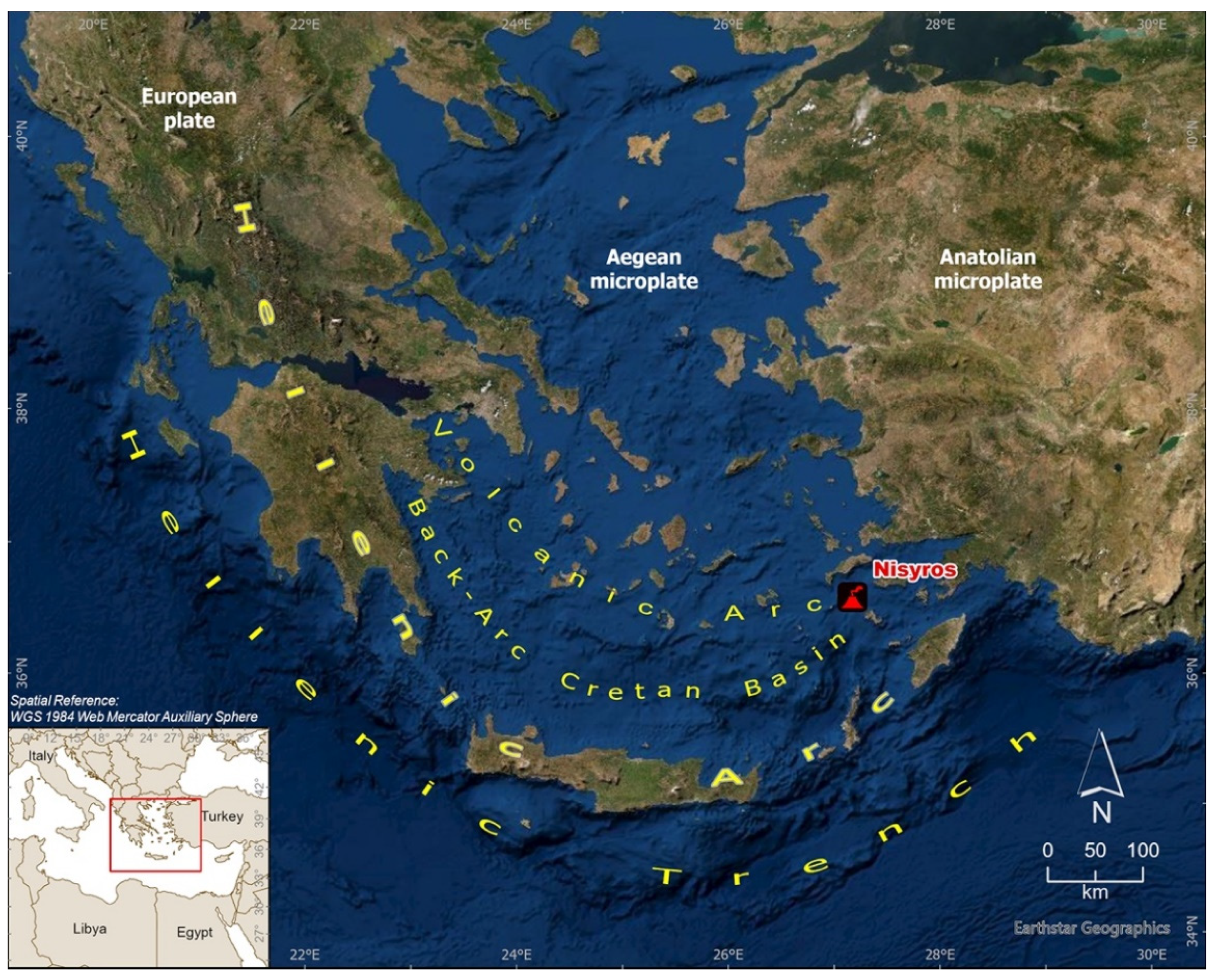
Nisyros is part of the Dodecanese group of islands in the eastern Aegean Sea. It is an active volcano that constitutes the southeastern end of the South Aegean Volcanic Arc (SAVA) and is situated within an active volcanic field that generated the largest volcanic eruption in the Eastern Mediterranean Sea (Kos Plateau Tuff) [18] (Figure 1).
Modern-day South Aegean Volcanic Arc extends over approximately 600 km, from Saronic Gulf to the islands of Kos and Nisyros near Minor Asia coast. It is defined by the volcanic centers of Sousaki, Aegina, Methana, Poros, Milos-Antimilos, Santorini, Koloumbo, Kos, Yali, and Nisyros, starting from the northwestern part down to the southeastern part [18] (Figure 1). It belongs to the Hellenic Orogenic Arc, which is formed along the convergent plate boundary of the northwards subducting African plate underneath the active margin of the European plate. As a result of subduction and extension, magmatic activity occurred throughout the extensional realm from Middle Eocene to Late Miocene [19,20,21,22]. More precisely, the subducting African plate’s rocks started dehydrating during this process, as a result of the high temperatures that the plate encounters as it descends deeper into the Lithosphere. The melt that is produced from the partial melting process that occurs has a lower density than the surrounding rocks, and as a result, ascends toward the surface, penetrating the overlaying Eurasian plate rocks. Some volumes of this melt crystallize deep below in the lithosphere, and others remain in the liquid form of magma, which rises to the surface, thus creating volcanism. Approximately 5 million years ago, the spatial distribution of magmatism and volcanism migrated towards the south and west, thus leading to the development of the present-day situation, the South Aegean Volcanic Arc. Volcanic activity in the SAVA started 4.7 Ma and continues up to this day with the active, but dormant volcanoes of Methana, Santorini, Kolumbo, and Nisyros.
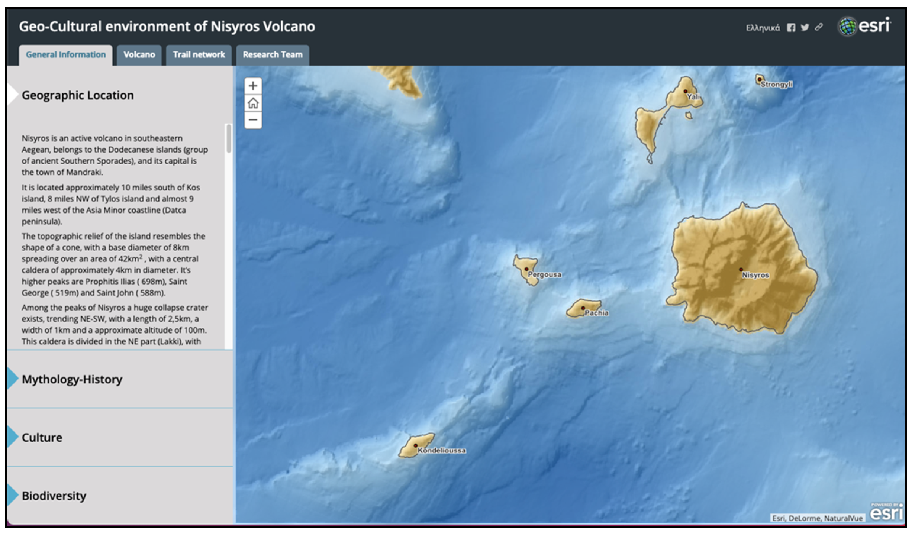
The island’s shape is almost circular, resembling the shape of a cone, with a total width of 8.5 km, a coastal circumference of about 25 km, and it covers an area of 42 km2 (Figure 2). The surrounding area of Nisyros consists of several smaller islands, which are Yali island to the north, Pachia and Pergoussa volcanic islets to the west, Strongyli volcanic islet to the northeast, and Kondelioussa islet further west, the biggest one [23,24]. Among the peaks of Nisyros (the majority of which are volcanic domes), a huge collapse crater exists, trending NE-SW, with a length of 2.5 km, a width of 1 km, and an approximate altitude of 100 m. This caldera is divided into two parts: the NE one (Lakki), featuring lush vegetation, and the SW one (Ramos) which hosts intense steam emissions.
Nisyros is entirely composed of Quaternary volcanic rocks with a ranging composition from basaltic andesites to rhyodacites. Geological studies on the island have been conducted by many researchers and institutions through the years (e.g., [25,26,27,28,29,30]). Nisyros Volcano is dissected by major fault zones forming a radial pattern around the Nisyros caldera [28,30,31,32].
By combining significant study results of many fields of volcanology, the volcanic history of Nisyros has been generally assigned to five major episodes [29] (Figure 3): In the beginning, subaerial basaltic-andesitic volcanism determined the early shield volcano cycles, followed by the development of a composite stratovolcano surrounded by several satellite eruption centers. Two major, rhyolitic plinian type, eruptions may have followed a caldera collapse, in the caldera-forming cycle, followed by the final phase of rhyodacitic dome effusion that filled the western interior of the caldera. According to [29], the five main volcanic events correspond to eruptive cycles of both mild and intense volcanic activity that lasted during longer or shorter time intervals. The last magmatic volcanic eruption dates back at least 24,000 years, leaving behind a hydrothermal system that is still active up to this day.
Today’s geodynamic regime of Nisyros is manifested via continuous seismic tremors, steam activity, and hydrothermal explosions. These occur due to the presence of groundwater, which is heated by the magma stored deeply underneath. As a result, it erupts violently at the surface (like a steaming cooking pan), forming the hydrothermal craters that lie at the bottom of the caldera, with the most important being Stephanos, Alexander (Flegethron), Logothetis, Mikros (Small), and Megalos (Big) Polyvotis and the Kaminakia craters [33]. The last hydrothermal explosion occurred in 1887 [34], forming the crater of Mikros Polyvotis. The whole system remains relatively dormant ever since, and at a state of low risk.
The above mentioned rich volcanic history, along with the steaming hydrothermal craters, the intensive smell of sulfur and fumarolic gases, and hot springs on the northern and southern shores of Nisyros, as well as with its rich human history, surprise the visitors of the island [29]. Due to its volcanic morphology and geographical position in the southeastern Aegean Sea, which make it a rather remote island, the cultural and historical heritage of Nisyros has been preserved through time, combining volcanological and geological wonders with the splendor of art and civilization, expressed through prehistoric and historic locations and monuments, such as churches, monasteries with hagiographic frescoes, castles, caves, and spas [35].
Till the writing of this paper, Nisyros is accessible by ferry from Kos island, where visitors can reach either by a domestic flight from Athens International Airport (or by international flights executed from some flight companies directly to Kos) or by ship from Piraeus Port. The accommodation is limited and the main means of public transportation on the island, unless visitors rent a car, is by bus which has a relatively limited itinerary. Furthermore, it is also important to mention the possibility for visitors to be accommodated at the nearby island of Kos, one of the most famous touristic destinations of Greece, and participate in a one-day cruise to Nisyros. Nevertheless, the current situation is constantly shifting as Nisyros tries to improve its touristic facilities and provide more options to its visitors, regarding a wide range of activities. Hence, the existence of an easy-to-use application like the presented Story Map is once again proved essential, because it gives another option to people that find it hard to approach and stay at the island, and that is to virtually explore and learn about it.
3. Materials and Methods
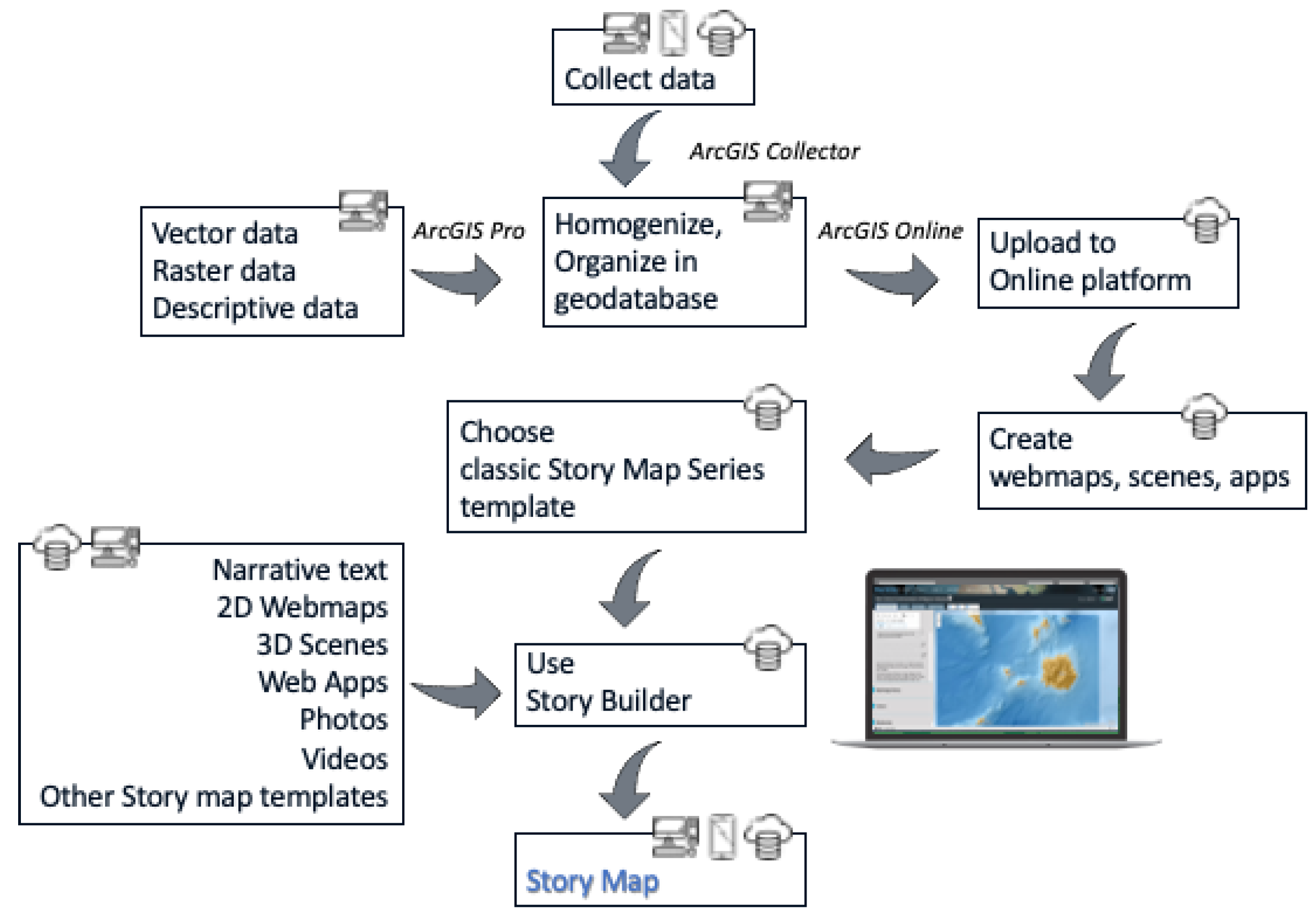
To create the Story Map of Nisyros island, aiming to present the volcanic as well as the anthropogenic environment of the island, different types of datasets have been compiled new or existing ones, either private or from open-source portals. Moreover, multiple data collection field trips have taken place, aiming to capture the exact location of each site of interest along with representative photos and videos to enrich the existing geo-cultural knowledge.
All the available (analog or digital) information for the area (bibliography, topographic map, geological structure, etc.) was collected, homogenized, organized, and lastly transformed to WGS 1984 Web Mercator (auxiliary sphere) projected coordinate system and stored in an ArcGIS Pro (https://tinyurl.com/yawowu3g) software geodatabase. ArcGIS Collector (https://tinyurl.com/yzrebtwh), available both for Android and iOS devices, was used to ensure the accuracy of the geographic location of collected data during fieldwork. For that purpose, at first, a second geodatabase was created to include the two vector feature classes designed for data collection: a point one, to store spatial and descriptive data for each site of interest along with multimedia content and a polyline one, to track the location of the existing walking trails network using GPS signal. In the next step, a webmap created and shared via ArcGIS Pro, having imagery as basemap and containing the two aforementioned feature classes was shared to ArcGIS Online (https://www.arcgis.com) platform, while individual parameters for each of the information layers, e.g., its symbol and the appearance or not of tags and pop-up menus, etc., as well as their refresh interval, were defined.
Many web platforms exist nowadays that allow for the development of a storytelling app, each one featuring different methods of data processing and visualization (e.g., thinglink (https://www.thinglink.com/), TimeMapper (http://timemapper.okfnlabs.org/), Google Earth Outreach (https://www.google.com/earth/outreach/), StoryMapJ (https://storymap.knightlab.com), Odyssey by CARTODB (https://cartodb.github.io/odyssey.js/). Some of the available options may require third-party apps to incorporate different presentation styles while others may also involve coding.
However, some platforms, like ESRI’s online one, used for this volcanic geosite promotion, offer all the tools needed to construct an efficient visualization of all the data without the need for other software to achieve the desired result. Story Maps created using ERSI’s platform are web-based applications that can be accessed from any online browser, without the need of being downloaded, while they can be viewed on any device, being freely available. Furthermore, they easily allow modifications and changes well after their initial launching. Any additional information or change within the app gets immediately updated after publishing the Story Map again, thus users get the most recent version automatically, the next time they open the app or by reloading it.
Having, also, in mind that all data mentioned before were created and already stored in ESRI’s platform (desktop and online), urged us to use for the main app, one of the available, open-sourced configured apps, called Story Map Series (https://tinyurl.com/yznu6klu).
The Story Map Series app, part of the classic Story Maps templates accessed also through a free, non-commercial ArcGIS public account, allows the presentation of the available information via tabs, side accordion control, or as numbered bullets, which is ideal for presenting a related set of maps showing different content for the same location as well as for jumping from one set of information to another without sequence. Furthermore, the app can be used and shared as provided by the platform, having the option to make minor CSS code modifications, or can be downloaded through GitHub, modified, and then served through a private server [36]. During the deployment of Nisyros Story Map, the first approach was followed due to the lack of a private server capable of managing a large number of users.
Finally, via the app’s interactive builder, narrative text with images, accompanied by 2D and 3D webmaps created in ArcGIS Pro according to the appropriate cartographic rules [37,38] and embedded content from other web apps or Story Map templates were combined in an engaging experience, as described in the following section (Figure 4).
4. The Story Map
The created Story Map (https://tinyurl.com/ycq5buvy) incorporates data regarding the geological and geographical characteristics of Nisyros, its cultural heritage along with its biodiversity as well as the different walking trails that highlight all the previous features (https://tinyurl.com/ycq5buvy). It offers detailed narrative text on the above topics accompanied by 2D webmaps and 3D scenes, as well as multimedia content like photos and links. The thematic maps used in the application were created in ArcGIS Pro and the desired parameters regarding the level of interaction for each map, like the zoom level, the function of pop-ups, and the initial orientation of the map/scene were determined both in the online platform and Story Map builder. Furthermore, to present effectively the available information, different Story Maps templates were embedded in the main one, as described below.
All the information was organized into four main categories covering (a) general information of the island, (b) geological and volcanological data of the development, evolution, and current state of the volcanic field, (c) a detailed description of the walking trails network, and (d) information presenting the research team, that is the scientists that actively supported this project.
Upon entering the interactive platform, users are asked to select between two languages, Greek and English (Figure 5). A short video loop plays in the background that slowly pans around the main highlights of the island’s volcanic heart, taken from the top of a volcanic dome within the caldera. The purpose of this video is to both motivate the users to explore further by revealing the impressive features from above and to demonstrate that, as, during a possible future visit to the island, they could easily reach beautiful vantage points with splendid views of the area, all by themselves, on foot or even by other means of transportation. The Story Map cascade template was used to create this part of the application.
Selection of language results in a new browser tab opening that leads to the main Story Map app, one for each language. The first view the users get is of a tabbed layout screen having four tabs at the top, below the title of the Story Map (Figure 6). They represent the four main categories of information on Nisyros island, with the first one regarding general information, being active. Sections below present the information that appears in each category.
4.1. General Information
A side accordion layout style, which uses a horizontal, expandable panel arrangement to present specific aspects of the area, each with its narrative text, multimedia, and web maps or scenes, was used (Figure 6).
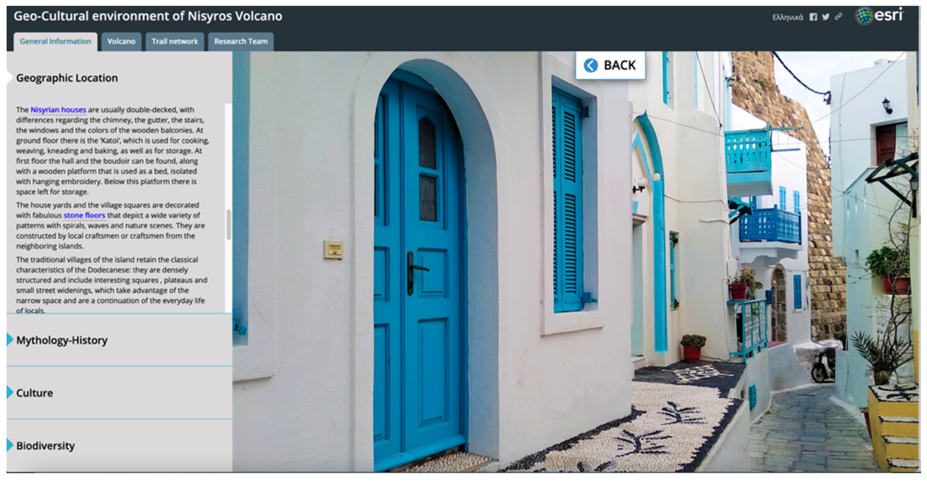
The narration starts with a presentation of the location of Nisyros within the Aegean Sea, the main morphological and volcanological features of the island such as the peaks, the caldera, the domes, and the hydrothermal craters, as well as brief touristic information. It is enhanced with the use of an image featuring a detailed Digital Elevation Model (DEM) derived from the digitization of topographic data from maps of scale 1:5000, as part of the [39]. On this model, users can initially identify all of the key geomorphological features of the island. Afterwards, it proceeds into presenting the most noteworthy architectural traits that reflect the island’s traditions and cultural heritage. The area to the right of the main text, the main stage, is used to enhance the narration either with interactive scenes or with representative photos, as shown in Figure 7. Users can select the highlighted words throughout the narration to change the main stage content.
Within the narrative text, separated words or phrases were used to assign internal links, the use of which replaces the interactive webmap either by high-resolution representative photos showing aspects of the Nisyros anthropogenic environment or by a web scene, that takes the viewer into a virtual tour of the main villages of Nisyros.
The second horizontal tab presents information about the mythology and history of the island. It incorporates photos accessed through internal links, reflecting the island’s past (Figure 8). The narrative text discusses the myth behind the formation of Nisyros that was conceptualized based on Gigantomachy’s descriptions of Apollodorus. Furthermore, it presents the users with all the possible scenarios regarding the origin of the island’s name along with its different variations through time, leading to the history of the island from prehistoric times, throughout the medieval era, until recent days.
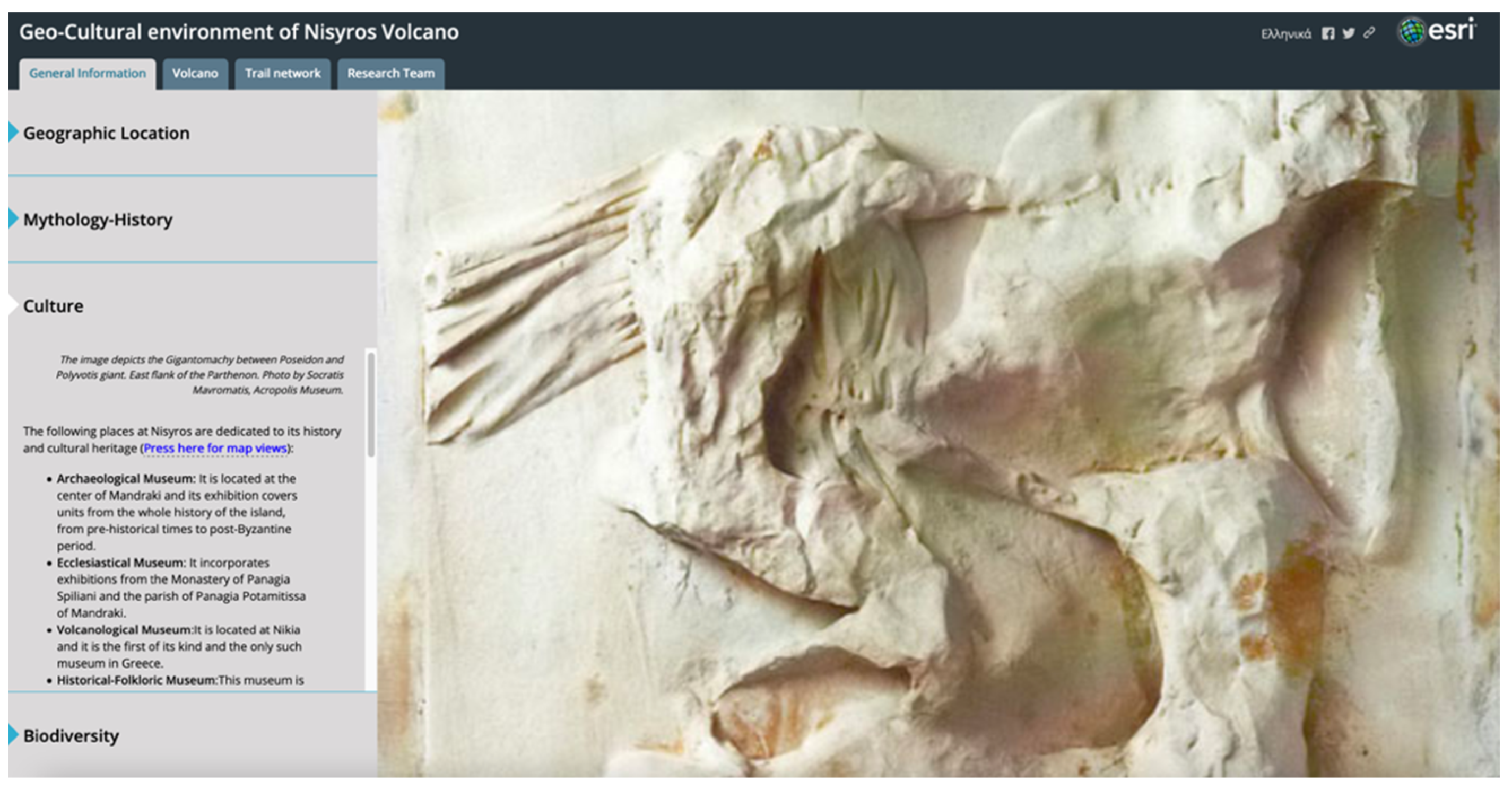
The third of the horizontal tabs includes all the places that feature the cultural heritage of the island, thus motivating users to visit themselves (Figure 9). It presents all the museums, churches, chapels, and monasteries of Nisyros, along with their geographical locations that are depicted on two different interactive web scenes, accessed through narration. The first one shows the location of the museums and archaeological sites and the second one, the location of churches, chapels, and monasteries.
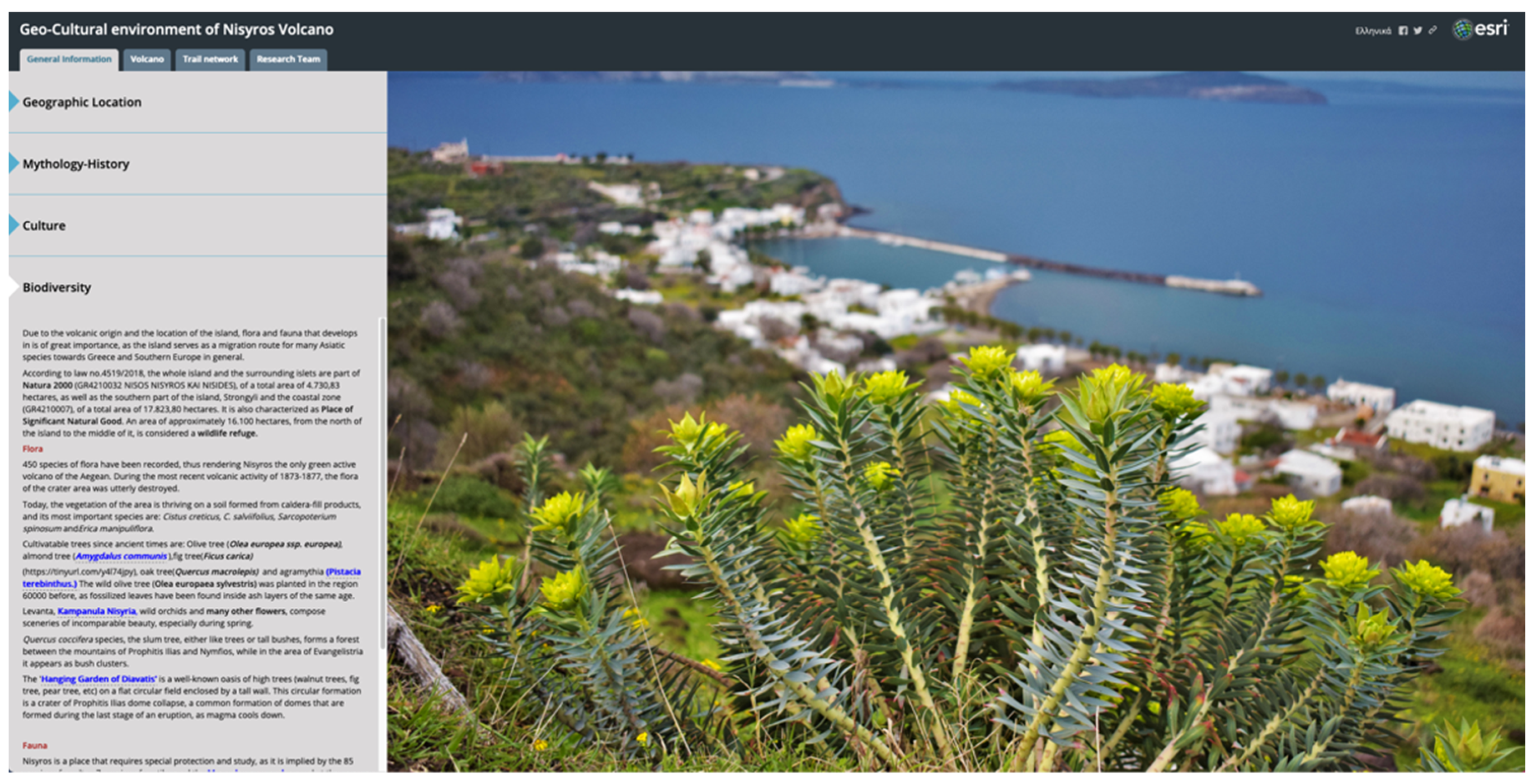
Finally, the fourth and last tab on Nisyros’ general information page is all about biodiversity (Figure 10). Following a brief introduction regarding the importance and recognition of the island as a place of significant natural beauty, the narrative text is divided into two sections; Flora, which describes some unique species of flowers, trees, and vegetation in general, and Fauna, which presents users with the wildlife that thrive in the island. Again, throughout the descriptions, users will find a great number of representative photos that enhance their experience by bringing words into life.
4.2. Volcano
The second tab at the top menu, named ‘Volcano’, focuses on the geology of Nisyros as an active volcano, as well as the general geotectonic environment that it is part of. Again, the side accordion layout style was used to organize the available information into four main horizontal panels.
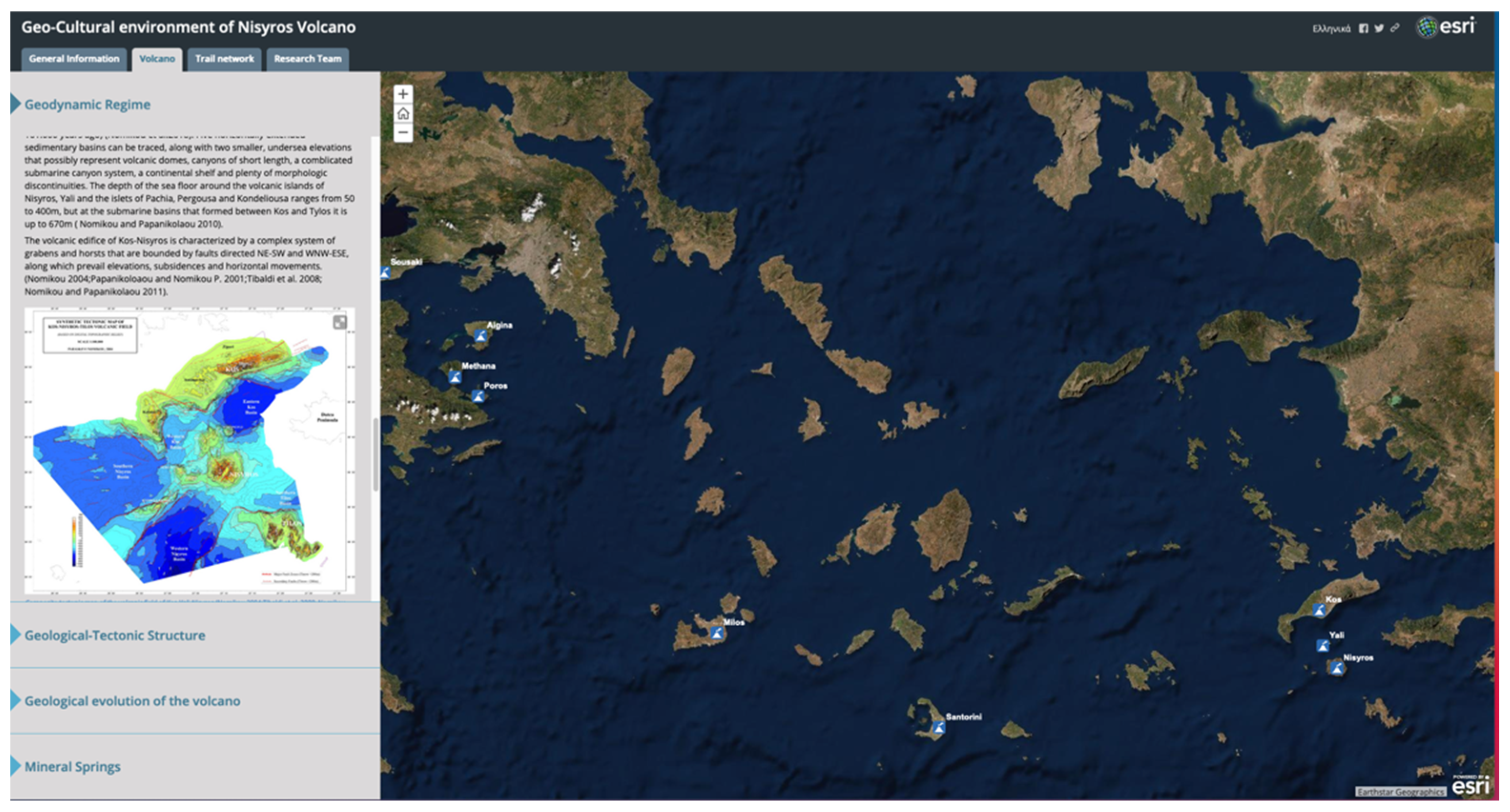
The first horizontal expandable panel describes the geodynamic regime of Nisyros by presenting the geometry and tectonic characteristics of the Hellenic subduction zone and the processes that lead to volcanism in the broader area (Figure 11). Descriptive text goes on to present the history of the South Aegean Volcanic Arc, with its north to south migration, while it is enhanced by an explanatory map that helps users to understand the space and time scale of this lithospheric event over the last 55 million years [40]. It finally gives users a glance into the study area’s geomorphological and tectonic characteristics. The narrative text is accompanied by an illustration of the orogenic arc as a cross-section, featuring the location of the study area, and a composite topographic—bathymetric map that shows the location of all the volcanic centers along the arc [18]. An interactive web map accompanies the narration, featuring the volcanic centers along the Volcanic Arc projected on a high-resolution satellite basemap.
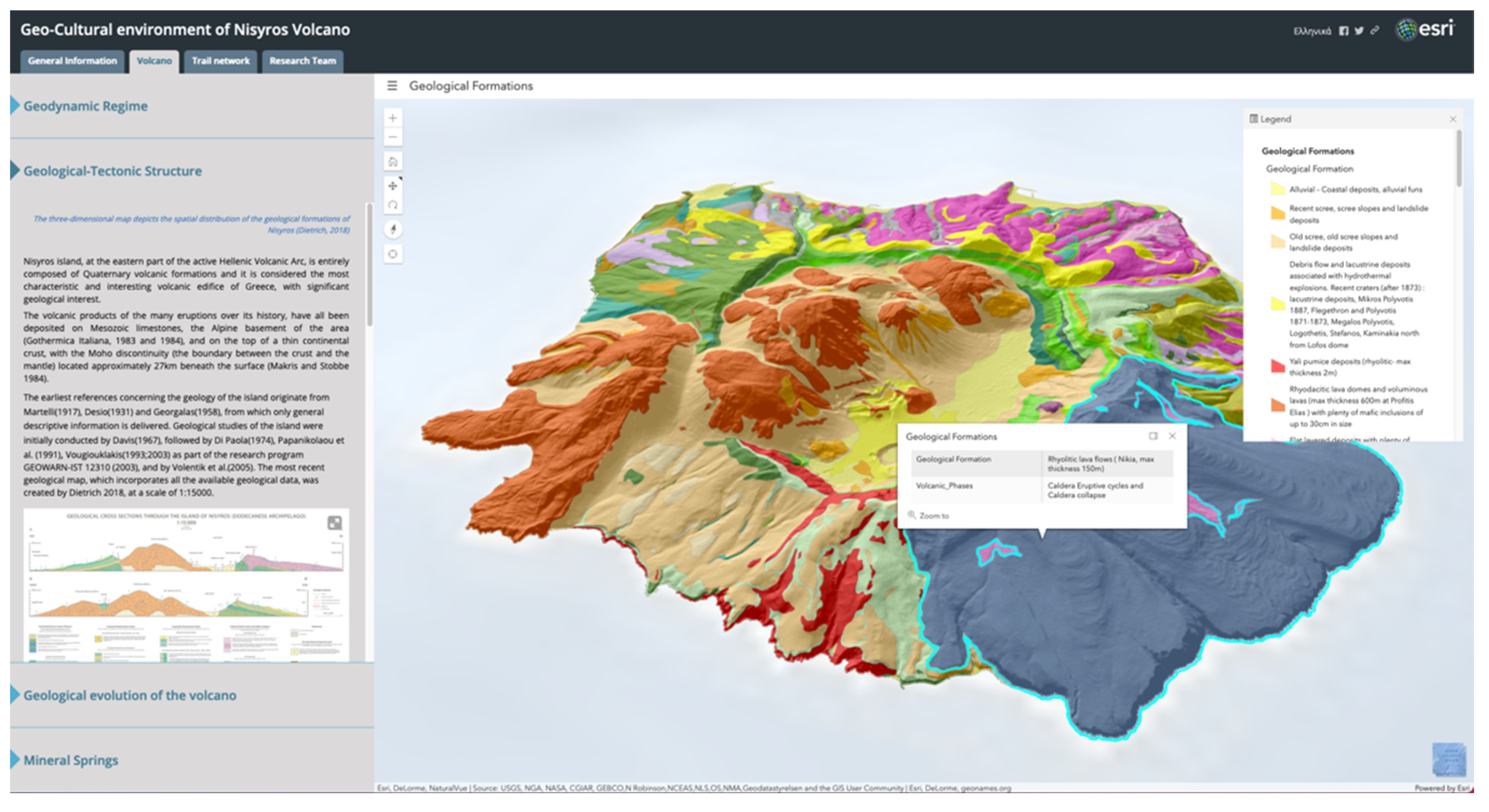
The second horizontal tab summarizes information regarding the volcano on a lithospheric scale and describes the two categories of fault systems that crosscut the island (Figure 12). It also features the earliest studies that have been conducted on the area, leading up to the most recent and detailed field mapping work of [29]. Apart from narrative text, users will also find an image with two representative cross-sections of the island as well as a detailed tectonic map of the fault zones of Nisyros [23,25,26,27,28,29,30,31,32,34,39,41,42,43,44,45,46]. The most prominent, however, feature of this tab is the interactive 3D web scene to the right, which depicts the spatial distribution of the geological formations of Nisyros. Users can use both the left and right buttons on the mouse to move the map and rotate it respectively. With the available tools on the left side of the scene, they can select the desired focus, change zoom levels or reverse to the initial predefined position. At the bottom right of the screen, different basemap styles can be selected with the click of a button, while by selecting a formation, a pop-up provides further information. By expanding the menu located to the left of the web scene title, the entire legend can be triggered and displayed to the right side of the screen. This web scene gives a unique opportunity to discover the traces of the island’s volcanic past layer by layer and to admire the complexity of fieldwork that needs to be undertaken in areas like this, to produce highly detailed geological maps of volcanic regions.
The third horizontal tab presents the evolution of the volcano through time, by describing the five major volcanic phases that have taken place to form the island (Figure 13). Apart from narrative text, an image with schematic depictions of the different stages of evolution is presented. To the right, users can visualize the different eruptive events that gave Nisyros its present-day morphological shape, by activating the player or by manually advancing time for the different volcanic formations corresponding to each phase to appear on the map. This demonstration of the evolution of the volcano is a unique capability of the Story Mapping platform, as it has the potential to actively engage audiences and help them understand complex mechanisms that originally require scientific lectures or even field trips to fully envisage and can have an immensely positive impact on promoting volcanic geoheritage around the world.
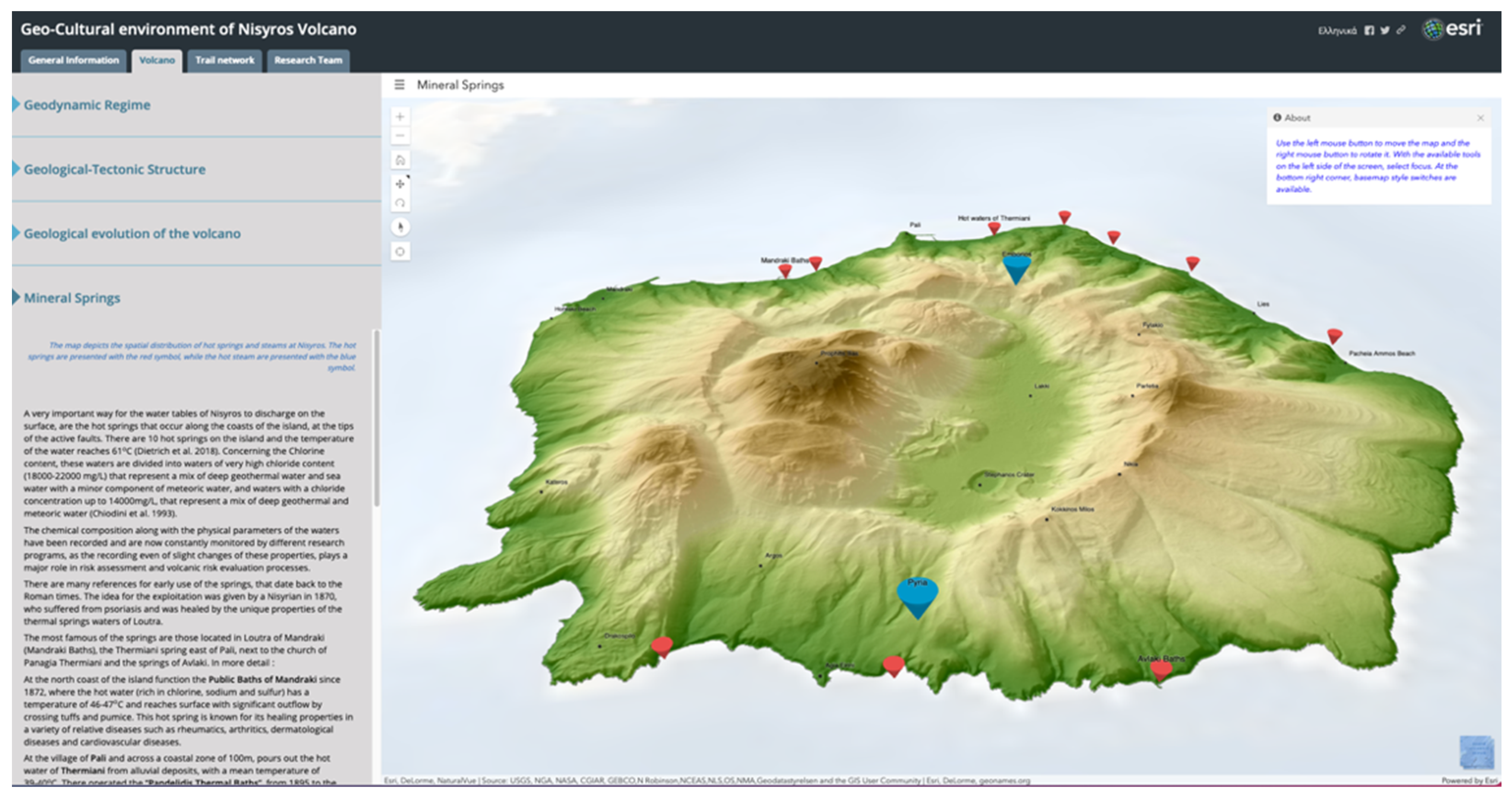
The last horizontal tab focuses on the current state of the volcano and a characteristic for which is mostly known since antiquity: mineral springs (Figure 14). It describes some basic physical and chemical characteristics of both onshore and offshore thermal water manifestations along with information on their use since ancient times. It then gives details of the most prominent springs of the island, along with a representative photo of an underwater spring that can attract divers to explore further. The interactive 3D web scene to the right specifies the location for both hot springs and hot steam emissions. An infobox at the upper right corner of every scene in the Story Map guides the users on how to interact with it, thus allowing for maximizing the experience.
4.3. Trail Network
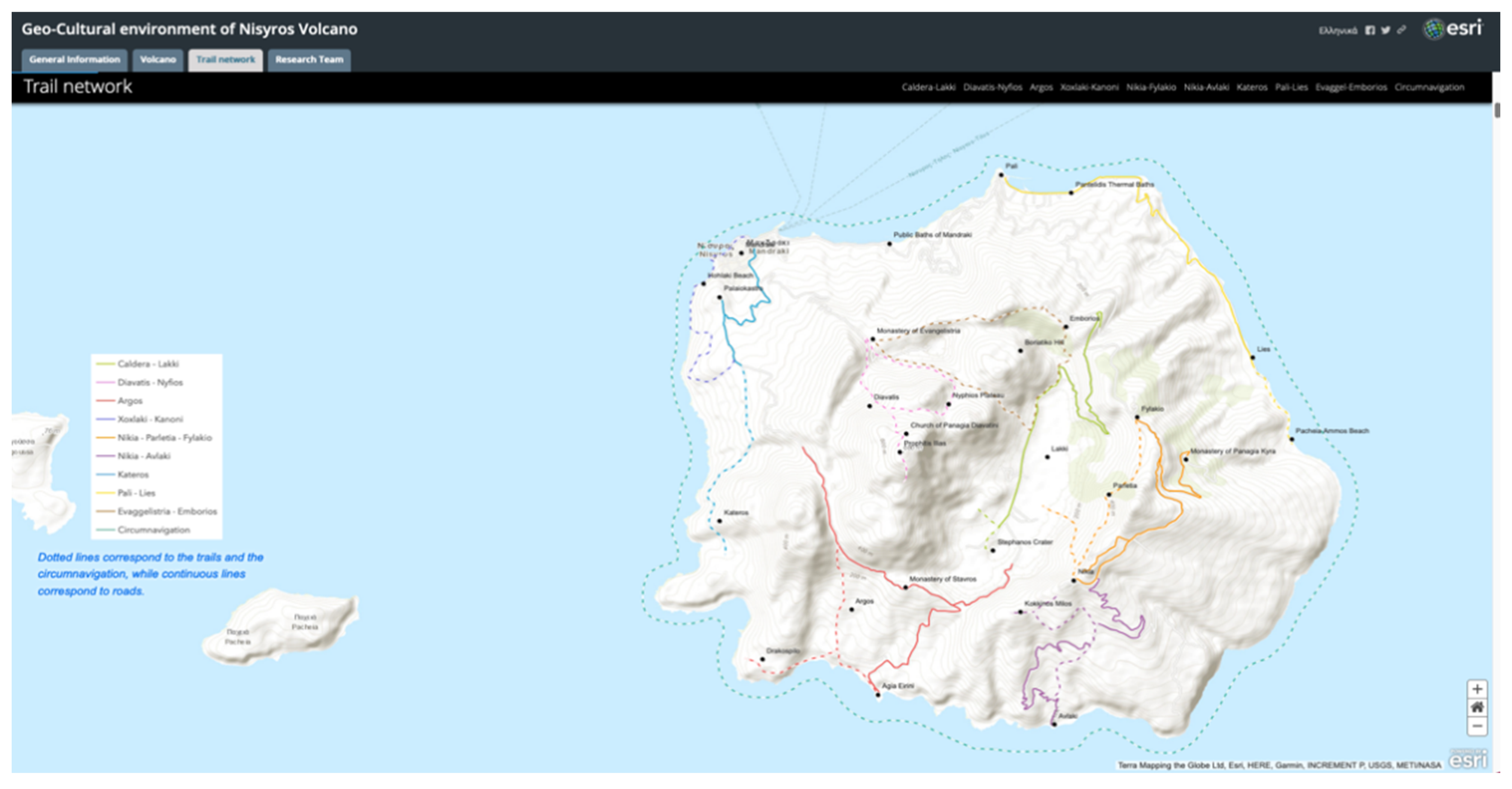
The third tab at the top of the screen is the presentation of the trail network of the island. Ten touristic routes were proposed and described, that take users into a virtual field trip across Nisyros and gives them a first chance of admiring the natural and cultural heritage of the place (Figure 15).
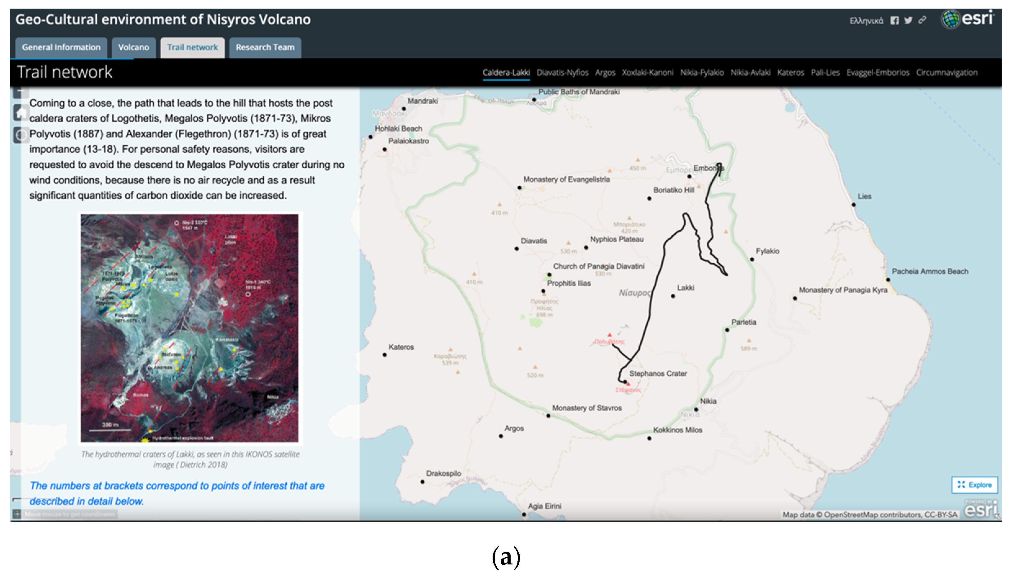
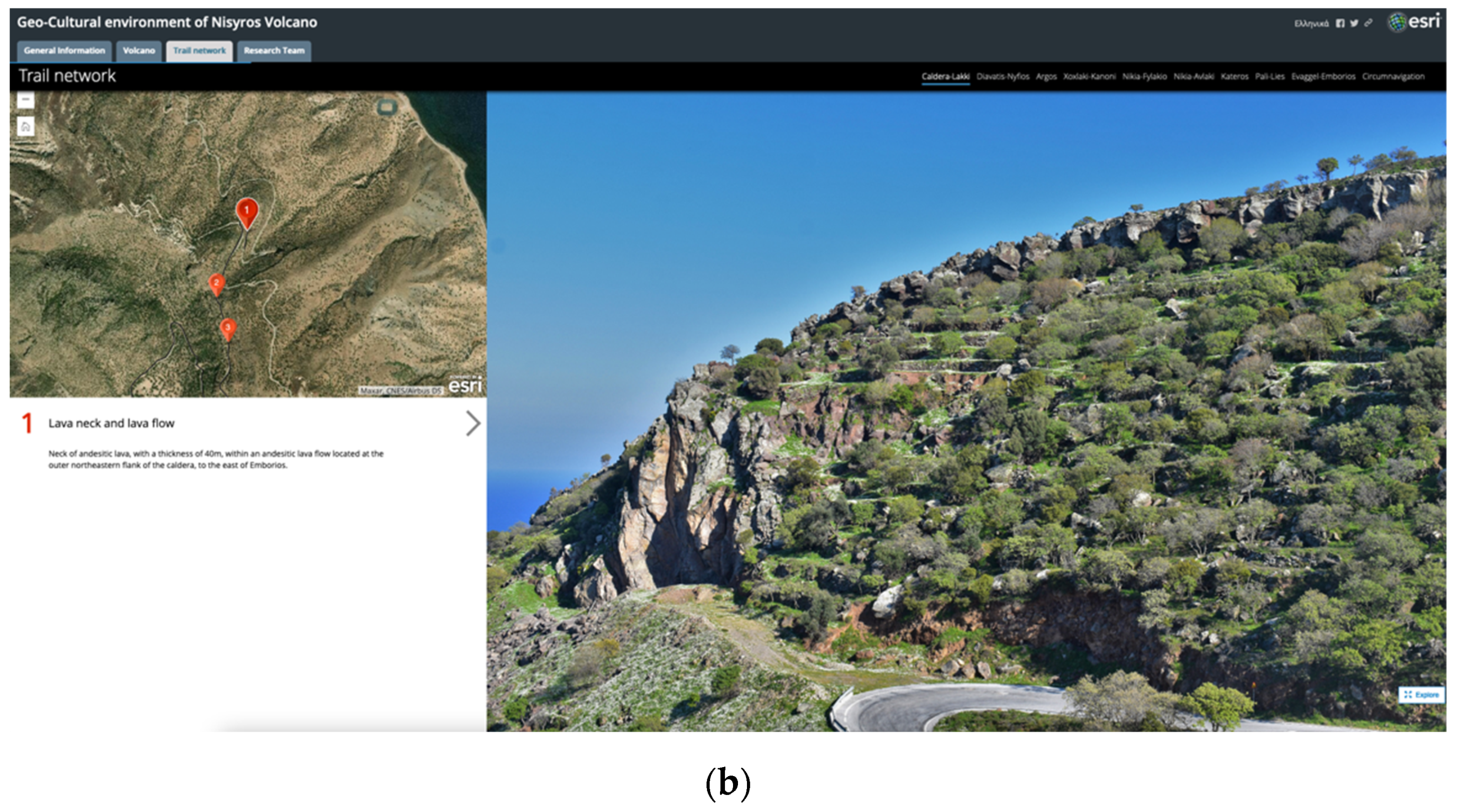
Story Map Cascade template was chosen to present each of the nine trails along with the circumnavigation of the island. A general description of the sights that can be viewed is given accompanied by a web app, created using Web AppBuilder, where an interactive 2D map shows the trace of the route (Figure 16a). Users, activating the ‘Explore’ button at the bottom right corner of the screen, can hover their mouse on the map to reveal geographic coordinates of a point of interest or when they are infield, they can use the ‘My Location’ button to see their location on the map. Following this general section, using an embedded Story Map Tour template, a more detailed tour of several selected points of interest can be found (Figure 16b). Once exploration is activated, users can select a numbered point on the web map to see each specific point of interest’s description and navigate around the area transitioning between various points without sequence. Imagery is used as a basemap to reveal the topography of the area. Users have also the option to follow a guided narration of the route, following the numbered order, using the arrows in the description section.
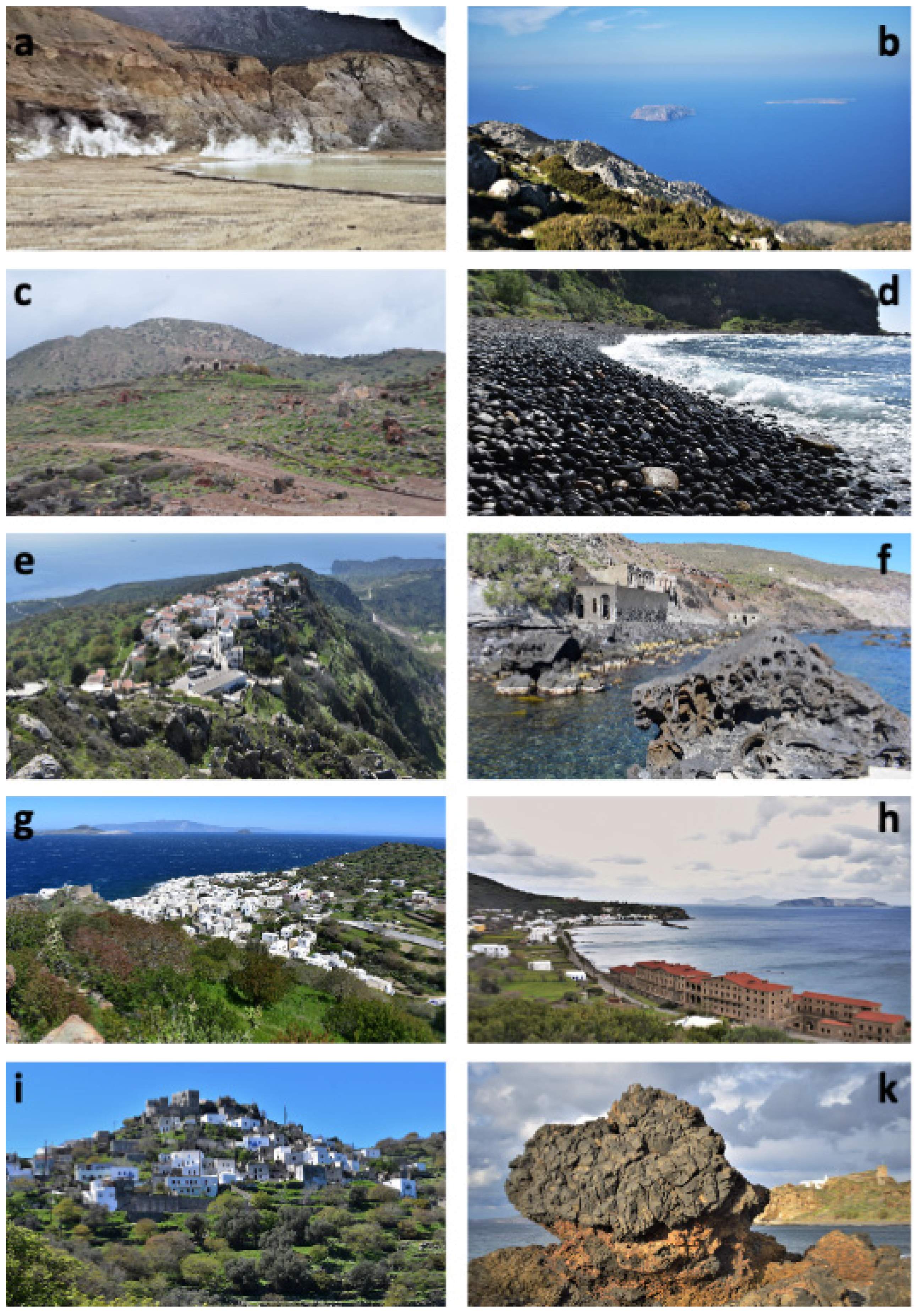
Navigating the proposed routes virtually with the Story Map provides a strong base for real-world exploration during a possible future visit, by combining the simplicity of narration with the detailed mapping, the representative photos/videos and description of each trail, and the general ease of use regarding the application. Figure 17 consists of representative photos for each trail, available in the Story Map, for which a brief description is as follows.
‘Caldera-Lakki’ trail presents a series of volcanic features representative of the geology of the island. Starting from the old and abandoned village of Emborios, it takes visitors down to the caldera (Lakki plain) from the eastern rim, passing by spectacular road cuts where volcanic layers of different eruptive cycles are exposed. The route finishes at the field of the active hydrothermal craters where visitors can descend to the interior of Stefanos, the biggest one, and admire the rumble caused by the hydrothermal fluids running under their feet as well as bubbling mud pools (after rainy days) and sulfur crystals (Figure 16a and Figure 17a).
‘Diavatis-Nymfios’ trail starts from the monastery of Evangelistria and splits into two trails. The first one leads visitors to the highest point of the island, which is the top of Profitis Ilias rhyodacitic dome, a place offering exceptional views of the caldera with the hydrothermal craters as well as the surrounding islands (Figure 17b). The second trail leads visitors to the impressive Nymfios plateau. Throughout the route, several traditional churches and chapels can be found.
‘Argos’ trail starts from Mandraki and takes visitors to the area of Argos, at the western slopes of the island. Important locations that it passes through are the archaeological field of Argos, with remnants from the Neolithic period up to the last century, the old sulfur processing plant, which does not function today, and Drakospilo cave (Figure 17c).
‘Xoxlaki-Kanoni’ trail is characteristic, as it guides visitors through Mandraki, the biggest settlement of Nisyros, the main port, and the capital. It continues at Xoxlaki beach (Figure 17d), famous for its black peddles, where it exposes pillow-lavas, the oldest volcanic rocks on the island. It also passes from the monastery of Panagia Spiliani, one of the island’s most famous and sacred locations.
‘Nikia-Fylakio’ trail starts either from the settlement of Nikia towards Fylakio, or vice versa. It offers a great number of unique points where visitors can admire splendid views of the entire island and the Aegean Sea (Figure 17e). The most prominent location is the traditional settlement of Nikia, which is built on the southeastern rim of the caldera and features the only museum of volcanology of Greece.
‘Nikia-Avlaki’ trail starts from Nikia and descends towards the southern coast of the island. Across this route, visitors can admire rhyolitic domes and lavas along with pyroclastics (Figure 17f). At Avlaki cove, remnants of an old settlement with hot baths that used to make good use of a local thermal spring can be found.
‘Kateros’ trail traverses almost the entire west coast of the island, starting from Mandraki (Figure 17g). Characteristic landmarks of the route are Palaiokastro, the imposing ancient acropolis of Nisyros (Figure 8), Kateros cove, and the Karaviotis rhyodacitic dome that features the youngest lavas of the volcano.
‘Pali-Lies’ trail starts from the settlement of Pali and traverses the northeastern coast of the island. Along this route, visitors will explore the locations of some of the most famous thermal springs of Nisyros, like the Pantelides thermal baths (Figure 17h) that do not function today. They will also observe some of the most impressive areas of the volcanic stratigraphy of Nisyros.
‘Evaggelistria-Emborios’ trail explores the northern rim as well as different rhyodacitic domes that are located within the caldera. After passing close to basaltic-andesitic volcanic necks, it ends up to the settlement of Emdorios, abandoned since the 1933 earthquake that struck the area (Figure 17i).
Finally, doing the ‘Circumnavigation’ is one of the best ways to explore the different eruptive phases of the volcano, access some of the most prominent sequences of volcanic products that are hardly accessible from land, and, in general, make the most out of its unique geoheritage sites (Figure 17k).
4.4. Research Team
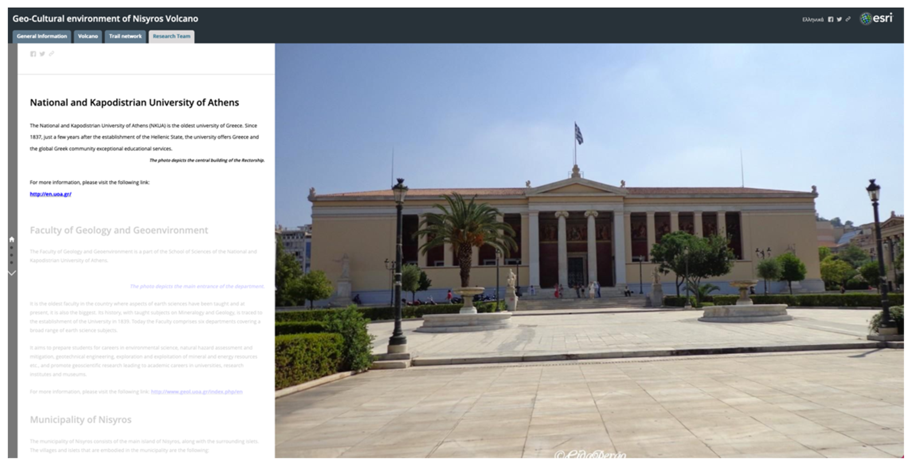
The fourth and final tab at the top of the screen refers to the research team, the group of scientists responsible for gathering all information, building the web maps and scenes, and designing the Story Map platform (Figure 18). A Story Map Journal template is embedded here presenting the National Kapodistrian University of Athens (NKUA) as well as the Faculty of Geology and Geoenvironment which undertook the execution of this Applied Science Project. It proceeds with the Municipality of Nisyros that funded the project and finishes by giving additional information for each member of the team.
5. Discussion-Conclusions
In this paper, an effort was made to describe a web application created using a GIS tool, Story Maps, provided by ESRI’s online platform, to present the geo-cultural environment of Nisyros Volcano, a unique volcanic geosite, to broad audiences.
In our day and age, it is of crucial importance to be able to deliver proper scientific knowledge on volcano-related topics so that people start realizing their different, ever-changing landscapes and banish the established classic, unchanging, cone-shaped mountain perception of volcanoes.
Story Maps presents more interactivity compared to the classical maps, allowing the user to interact with the map, and use it to visualize, from different perspectives, the content of interest, while the narration facilitates the transformation of data into information and ultimately into knowledge [15,47]. Furthermore, having an easily manageable interface for both the app developers and the end-users allows the combination of different scientific fields in the same application, while disseminating scientific findings to broader professional or non-specialized audiences of all ages [48,49].
Specifically, the app is responsive to screen size and it responds quickly, allowing for an easy navigational experience, giving users the opportunity to interact with the maps and the incorporated media to an extent that is set by the developers. Thus, they can easily explore the content, using the available features that were built in the platform based on the selected method of narration, such as tabs that group the data according to their nature, navigation buttons that control the available map views, and pop-ups that present specific information, usually describing points of interest along a selected mapped route.
While the combination of available data is successfully achieved using this tool, GIS analysis and processing tools provided by the online platform are still limited making mandatory the use of a GIS desktop software. Another issue is that being a developing tool, frequent upgrades can cause technical problems either upon building or may require corrections to already created applications.
The developed tailored story, as shown also in previous attempts [11,36,50,51] can be an ideal way for presenting the entire available information for a place, especially for places that can be characterized as geosites or protected areas worldwide (e.g., Natura 2000 areas). Finally, being a web app that can be shared to social media or embedded to other websites can rapidly spread to the general public, providing the opportunity for a visual guided tour, especially during the current global situation, derived from the COVID-19 pandemic.
Author Contributions
Conceptualization, V.A. and P.N.; data curation, V.A.; formal analysis, V.A. and P.N.; funding acquisition, P.N.; investigation, P.N. and E.Z.; methodology, V.A.; project administration, P.N.; resources, E.Z.; software, V.A.; supervision, V.A.; validation, V.A. and P.N.; visualization, V.A.; writing–original draft preparation, V.A. and D.P.; writing–review and editing, V.A., P.N., D.P. and E.Z. All authors have read and agreed to the published version of the manuscript.
Funding
This study has been conducted in the framework of the Research Project “Recording and highlighting the trail network of Nisyros Municipality using modern means of online digital cartography” and funded by DIKEN Nisyrou. The research paper was partially funded by the Special Account for Research Grants (S.A.R.G.) of the National and Kapodistrian University of Athens (Greece).
Institutional Review Board Statement
Not applicable.
Informed Consent Statement
Not applicable.
Data Availability Statement
The data presented in this study are available on request from the corresponding author.
Acknowledgments
The authors would like to acknowledge the “RESEARCH-CREATE-INNOVATE” of the “Competitiveness, Entrepreneurship and Innovation (EPANEK),” NSRF 2014-2020, R.G. 15336 (Research project: VIRTUALDiver) for the Department of Geology and Geoenvironment.
Conflicts of Interest
The authors declare no conflict of interest.
References
- Németh, K.; Casadevall, T.; Moufti, M.R.; Marti, J. Volcanic Geoheritage. Geoheritage 2017, 9, 251–254. [Google Scholar] [CrossRef] [Green Version]
- Cook, T.; Abbott, L. Geoheritage: Preserving Earth’s Legacy. Earth Mag. Available online: https://www.earthmagazine.org/article/geoheritage-preserving-earths-legacy (accessed on 25 January 2021).
- Pasquaré Mariotto, F.; Bonali, F.L.; Venturini, C. Iceland, an Open-Air Museum for Geoheritage and Earth Science Communication Purposes. Resources 2020, 9, 14. [Google Scholar] [CrossRef] [Green Version]
- Dóniz-Páez, J.; Beltrán-Yanes, E.; Becerra-Ramírez, R.; Pérez, N.M.; Hernández, P.A.; Hernández, W. Diversity of Volcanic Geoheritage in the Canary Islands, Spain. Geosciences 2020, 10, 390. [Google Scholar] [CrossRef]
- Erfurt-Cooper, P. Geotourism in volcanic and geothermal environments: Playing with fire? Geoheritage 2011, 3, 187–193. [Google Scholar] [CrossRef]
- Martí, J.; Planagumà, L. La Garrotxa Volcanic Field of Northeast Spain; Geoheritage, Geoparks and Geotourism; Springer International Publishing: Cham, Switzerland, 2017; ISBN 978-3-319-42078-3. [Google Scholar]
- Woo, K.S.; Sohn, Y.K.; Yoon, S.H.; Ahn, U.S.; Spate, A. Jeju Island Geopark—A Volcanic Wonder of Korea; Geoparks of the World; Springer: Berlin/Heidelberg, Germany, 2013; Volume 1, ISBN 978-3-642-20563-7. [Google Scholar]
- Moufti, M.R.; Németh, K. Geoheritage of Volcanic Harrats in Saudi Arabia; Geoheritage, Geoparks and Geotourism; Springer International Publishing: Cham, Switzerland, 2016; ISBN 978-3-319-33013-6. [Google Scholar]
- Németh, K. P. Erfurt-Cooper (ed): Volcanic tourist destinations and E. Errami, M. Brocx, and V. Semeniuk (eds): From geoheritage to geoparks: Case studies from Africa and beyond. Bull. Volcanol. 2016, 78, 1–5. [Google Scholar] [CrossRef]
- Errami, E.; Schneider, G.; Ennih, N.; Randrianaly, H.N.; Bendaoud, A.; Noubhani, A.; Norman, N.; Allan, M.; Vasconcelos, L.; Costa, L.; et al. Geoheritage and Geoparks in Africa and the Middle-East: Challenges and Perspectives; Errami, E., Ed.; Geoheritage to Geoparks, Geoheritage, Geoparks and Geotourism; Springer International Publishing: Cham, Switzerland, 2015; pp. 3–23. [Google Scholar] [CrossRef]
- Antoniou, V.; Ragia, L.; Nomikou, P.; Bardouli, P.; Lampridou, D.; Ioannou, T.; Kalisperakis, I.; Stentoumis, C. Creating a Story Map Using Geographic Information Systems to Explore Geomorphology and History of Methana Peninsula. ISPRS Int. J. Geo-Inf. 2018, 7, 484. [Google Scholar] [CrossRef] [Green Version]
- Groshans, G.; Mikhailova, E.; Post, C.; Schlautman, M.; Carbajales-Dale, P.; Payne, K. Digital Story Map Learning for STEM Disciplines. Educ. Sci. 2019, 9, 75. [Google Scholar] [CrossRef] [Green Version]
- Thöny, M.; Schnürer, R.; Sieber, R.; Hurni, L.; Pajarola, R. Storytelling in Interactive 3D Geographic Visualization Systems. ISPRS Int. J. Geo-Inf. 2018, 7, 123. [Google Scholar] [CrossRef] [Green Version]
- Jones, A.; Blake, C.; Davies, C.; Scanlon, E. Digital maps for learning: A review and prospects. Comput. Educ. 2004, 43, 91–107. [Google Scholar] [CrossRef]
- Berendsen, M.; Hamerlinck, J.; Webster, G. Digital Story Mapping to Advance Educational Atlas Design and Enable Student Engagement. ISPRS Int. J. Geo-Inf. 2018, 7, 125. [Google Scholar] [CrossRef] [Green Version]
- Sundin, A.; Andersson, K.; Watt, R. Rethinking communication: Integrating storytelling for increased stakeholder engagement in environmental evidence synthesis Neal Haddaway, Sally Crowe. Environ. Evid. 2018, 7, 6. [Google Scholar] [CrossRef]
- Kerski, J.J. Geo-awareness, Geo-enablement, Geotechnologies, Citizen Science, and Storytelling: Geography on the World Stage. Geogr. Compass 2015, 9, 14–26. [Google Scholar] [CrossRef]
- Nomikou, P.; Papanikolaou, D.; Alexandri, M.; Sakellariou, D.; Rousakis, G. Submarine volcanoes along the aegean volcanic arc. Tectonophysics 2013, 597–598, 123–146. [Google Scholar] [CrossRef]
- Innocenti, F.; Manetti, P.; Peccerillo, A.; Poli, G. South Aegean volcanic arc: Geochemical variations and geotectonic implications. Bull. Volcanol. 1981, 44, 377–391. [Google Scholar] [CrossRef]
- Fytikas, M.; Innocenti, F.; Manetti, P.; Peccerillo, A.; Mazzuoli, R.; Villari, L. Tertiary to Quaternary evolution of volcanism in the Aegean region. Geol. Soc. Spec. Publ. 1984, 17, 687–699. [Google Scholar] [CrossRef]
- Pe-Piper, G.; Piper, D.J.W.; Kotopouli, C.N.; Panagos, A.G. Neogene volcanoes of Chios, Greece: The relative importance of subduction and back-arc extension. Geol. Soc. Spec. Publ. 1994, 81, 213–231. [Google Scholar] [CrossRef]
- Pe-Piper, G.; Piper, D.J.W. The Igneous Rocks of Greece. The Anatomy of an Orogen. Geol. Mag. 2003, 140, 357. [Google Scholar] [CrossRef]
- Nomikou, P.; Papanikolaou, D. Extension of active fault zones on Nisyros volcano across the Yali-Nisyros Channel based on onshore and offshore data. Mar. Geophys. Res. 2011, 32, 181–192. [Google Scholar] [CrossRef]
- Papanikolaou, D.; Nomikou, P. Tectonic structure and volcanic centers at the eastern edge of the aegean volcanic arc around Nisyros island. Bull. Geol. Soc. Greece 2001, 34, 289. [Google Scholar] [CrossRef]
- Davis, E.N. Zur Geologie und Petrologie der Inseln Nisyros und Jali (Dodekanes). Geol. Rundsch. 1968, 57, 811–821. [Google Scholar] [CrossRef]
- Di Paola, G.M. Volcanology and petrology of Nisyros Island (Dodecanese, Greece). Bull. Volcanol. 1974, 38, 944–987. [Google Scholar] [CrossRef]
- Vougioukalakis, G. Volcanic stratigraphy and evolution of Nisyros island (Abstracts). Bull. Geol. Soc. Greece 1993, 28, 239–258. [Google Scholar]
- Volentik, A.; Vanderkluysen, L.; Principe, C.; Hunziker, J.C. Stratigraphy of Nisyros volcano (Greece). In The Petrology and Geochemistry of Lavas and Tephras of Nisyros Volcano (Greece); Hunziker, J.C., Marini, L., Eds.; Mémoires de Géologie: Lausanne, Switzerland, 2005; Volume 44, pp. 26–66. [Google Scholar]
- Dietrich, V.J.; Lagios, E. (Eds.) Nisyros Volcano. In Active Volcanoes of the World; Springer International Publishing: Cham, Switzerland, 2018; ISBN 978-3-319-55458-7. [Google Scholar]
- Papanikolaou, D.; Lekkas, E.; Sakellariou, D. Geological structure and evolution of the Nisyros volcano. Bull. Geol. Soc. Greece 1991, 25, 405–419. [Google Scholar]
- Tibaldi, A.; Pasquarè, F.A.; Papanikolaou, D.; Nomikou, P. Tectonics of Nisyros Island, Greece, by field and offshore data, and analogue modelling. J. Struct. Geol. 2008, 30, 1489–1506. [Google Scholar] [CrossRef]
- Nomikou, P. Contribution to the Geodynamics of the Dodecanese: The Submarine area of Kos-Nisyros Islands. Ph.D. Thesis, National and Kapodistrian University of Athens, Athens, Greece, 2004; p. 476. [Google Scholar]
- Gorceix, M. Sur la récente éruption de Nisyros. CR Acad. Sci. Paris 1873, 77, 1039. [Google Scholar]
- Martelli, A. Il gruppo eruttivo di Nisiro nel mare Egeo. Mem. Mat. Fis. Soc. Ital. Soc. 1917, 20, 79–165. [Google Scholar]
- Antoniou, V.; Nomikou, P.; Zafeirakopoulou, E.; Bardouli, P.; Ioannou, T. Geo-biodiversity and cultural environment of Nisyros volcano. In Proceedings of the 5th International Congress of the Geological Society of Greece—Bulletin of the Geological Society of Greece, Athens, Greece, 22–24 May 2019; pp. 687–688. [Google Scholar]
- Antoniou, V.; Vassilakis, E. Diffusion of Geo-Environmental Datasets through Online Interactive and Real-Time Applications. Case Study: The Natura GR2440006 Protected Area. Ann. Geogr. Stud. 2019, 2, 8–16. [Google Scholar]
- Dibiase, D.; Maceachren, A.M.; Krygier, J.B.; Reeves, C. Animation and the role of map design in scientific visualization. Cartogr. Geogr. Inf. Syst. 1992, 19, 201–214. [Google Scholar] [CrossRef]
- Newman, G.; Zimmerman, D.; Crall, A.; Laituri, M.; Graham, J.; Stapel, L. User-friendly web mapping: Lessons from a citizen science website. Int. J. Geogr. Inf. Sci. 2010, 24, 1851–1869. [Google Scholar] [CrossRef]
- GEOWARN-IST 12310. Geological Map of Greece, 1:10,000. Geo-Spatial Warning Systems Nisyros Volcano (Greece): An Emergency Case Study. Information Society Technologies Programme. Available online: www.geowarn.ethz.ch (accessed on 25 February 2021).
- Royden, L.H.; Papanikolaou, D.J. Slab segmentation and late Cenozoic disruption of the Hellenic arc. Geochem. Geophys. GeoSyst. 2011, 12. [Google Scholar] [CrossRef]
- Vougioukalakis, G.E. Sheet Nisyros, Geological Map of Greece, 1:25,000; IGME (Institute of Geology and Mineral Exploration): Athens, Greece, 2003. [Google Scholar]
- Georgalas, G. Nisyros Island. Nisyriaka Chron. 1958, 21, 23. [Google Scholar]
- Desio, A. Le Isole Italiane dell’Egeo—Studi geologici e geografici-fisici. Mem. Descr. Cart. Geol. d’Italia 1931, 24, 546. [Google Scholar]
- Geotermica Italiana. Nisyros 1 Geothermal Well; Unpublished PPC-EEC Report; 1983; p. 106. [Google Scholar]
- Geotermica Italiana. Nisyros 2 Geothermal Well; Unpublished PPC-EEC Report; 1984; p. 44. [Google Scholar]
- Makris, J.; Stobbe, C. Physical properties and state of the crust and upper mantle of the eastern Mediterranean Sea deduced from geophysical data. Mar. Geol. 1984, 55, 345–361. [Google Scholar] [CrossRef]
- Van Ho, Q.; Lundblad, P.; Astrom, T.; Jern, M. A web-enabled visualization toolkit for geovisual analytics. Inf. Vis. 2012, 11, 22–42. [Google Scholar] [CrossRef] [Green Version]
- Janicki, J.; Narula, N.; Ziegler, M.; Guénard, B.; Economo, E.P. Visualizing and interacting with large-volume biodiversity data using client-server web-mapping applications: The design and implementation of antmaps.org. Ecol. Inform. 2016, 32, 185–193. [Google Scholar] [CrossRef] [Green Version]
- Wright, D.J.; Verrill, A.; Artz, M.; Deming, R. Story Maps as an Effective Social Medium for Data Synthesis, Communication, and Dissemination. AGUFM 2014, 2014, IN33B-3773. [Google Scholar]
- Antoniou, V.; Nomikou, P.; Bardouli, P.; Sorotou, P.; Bonali, F.B.; Ragia, L.; Metaxas, A. The Story Map for Metaxa Mine (Santorini, Greece): A Unique Site Where History and Volcanology Meet Each Other. In Proceedings of the 5th International Conference on Geographical Information Systems Theory, Applications and Management, Crete, Greece, 3–5 May 2019; Volume 1, pp. 212–219. [Google Scholar] [CrossRef]
- Antoniou, V.; Nomikou, P.; Papaspyropoulos, K.; Zafeirakopoulou, E.; Vlasopoulos, O.; Xrysopoulou, E.-V.; Tziannou, E.; Ragia, L. Corinth Gulf Story Map: Enhancing Public Awareness in Natural and Anthropogenic Environment using Interactive GIS Applications. In Proceedings of the 6th International Conference on Geographical Information Systems Theory, Applications and Management, Prague, Czech Republic, 7–9 May 2020; Volume 1, pp. 262–269. [Google Scholar] [CrossRef]
Figure 1.
A simplified map showing the location of Nisyros Volcano in the South Aegean Volcanic Arc.
Figure 1.
A simplified map showing the location of Nisyros Volcano in the South Aegean Volcanic Arc.

Figure 2.
Digital Elevation Model (DEM) of Nisyros volcanic island. Main localities are also presented.
Figure 2.
Digital Elevation Model (DEM) of Nisyros volcanic island. Main localities are also presented.

Figure 3.
Volcanic phases of Nisyros volcanic island [29].
Figure 3.
Volcanic phases of Nisyros volcanic island [29].

Figure 4.
Workflow used in this Story Map.

Figure 5.
Screenshot showing Story Map’s home page where the title, as well as the selection between the languages, appear.
Figure 5.
Screenshot showing Story Map’s home page where the title, as well as the selection between the languages, appear.

Figure 6.
Screenshot showing the main part of the app that appears once a language is selected, featuring four main tabs-pages, each one of which includes additional information organized within vertical tabs. The first one, regarding general information, is active.
Figure 6.
Screenshot showing the main part of the app that appears once a language is selected, featuring four main tabs-pages, each one of which includes additional information organized within vertical tabs. The first one, regarding general information, is active.

Figure 7.
Screenshot showing the “stone floors”, a typical characteristic of Nisyros’s architecture. Users can select the highlighted words in the accompanying narration to change the main stage content.
Figure 7.
Screenshot showing the “stone floors”, a typical characteristic of Nisyros’s architecture. Users can select the highlighted words in the accompanying narration to change the main stage content.

Figure 8.
Screenshot showing the second horizontal tab of the general information category, where the photo of Palaiokastro, one of the most outstanding archaeological monuments of Nisyros, has been accessed.
Figure 8.
Screenshot showing the second horizontal tab of the general information category, where the photo of Palaiokastro, one of the most outstanding archaeological monuments of Nisyros, has been accessed.

Figure 9.
Screenshot showing part of the narration about the cultural heritage of the island accompanied by a photo depicting the Gigantomachy between Poseidon and Polyvotis giant.
Figure 9.
Screenshot showing part of the narration about the cultural heritage of the island accompanied by a photo depicting the Gigantomachy between Poseidon and Polyvotis giant.

Figure 10.
Screenshot showing part of the narration about biodiversity found on the island accompanied by high-resolution photos.
Figure 10.
Screenshot showing part of the narration about biodiversity found on the island accompanied by high-resolution photos.

Figure 11.
Screenshot showing part of the narration about the geodynamic regime of the island accompanied by the webmap featuring the location of all volcanic islands across the Hellenic Volcanic Arc.
Figure 11.
Screenshot showing part of the narration about the geodynamic regime of the island accompanied by the webmap featuring the location of all volcanic islands across the Hellenic Volcanic Arc.

Figure 12.
Screenshot showing part of the narration about the geological–tectonic structure of the island accompanied by a 3D interactive web scene featuring the spatial distribution of the geological formations. Users can select a formation to get further information.
Figure 12.
Screenshot showing part of the narration about the geological–tectonic structure of the island accompanied by a 3D interactive web scene featuring the spatial distribution of the geological formations. Users can select a formation to get further information.

Figure 13.
Screenshot showing part of the narration about the geological evolution of the volcano accompanied by a 2D webmap featuring the spatial distribution of the different eruptive phases that led to the island’s present-day morphological shape. Users can activate the player, or they can manually advance time for the different volcanic formations to appear on the map.

Figure 14.
Screenshot showing part of the narration about the mineral springs locates on the island accompanied by an interactive 3D web scene featuring the location for both hot springs (red circles) and hot steam emissions (blue marks).
Figure 14.
Screenshot showing part of the narration about the mineral springs locates on the island accompanied by an interactive 3D web scene featuring the location for both hot springs (red circles) and hot steam emissions (blue marks).

Figure 15.
Screenshot showing the spatial distribution of the trail network proposed and described in this app.
Figure 15.
Screenshot showing the spatial distribution of the trail network proposed and described in this app.

Figure 16.
Screenshots showing the two ways of presenting each trail, general information (a) and information for each point of interest (b).
Figure 16.
Screenshots showing the two ways of presenting each trail, general information (a) and information for each point of interest (b).


Figure 17.
Representative photos for each trail available in the Story Map: (a) Caldera-Lakki, (b) Diavaris-Nymfios, (c) Argos, (d) Xoxlaki-Kanoni, (e) Nikia-Fylakio, (f) Nikia-Avlaki, (g) Kateros, (h) Pali-Lies, (i) Evaggelistria-Emborios, (k) Circumnavigation.
Figure 17.
Representative photos for each trail available in the Story Map: (a) Caldera-Lakki, (b) Diavaris-Nymfios, (c) Argos, (d) Xoxlaki-Kanoni, (e) Nikia-Fylakio, (f) Nikia-Avlaki, (g) Kateros, (h) Pali-Lies, (i) Evaggelistria-Emborios, (k) Circumnavigation.

Figure 18.
Screenshot showing part of the content of the last tab referring to the Research Team.

Publisher’s Note: MDPI stays neutral with regard to jurisdictional claims in published maps and institutional affiliations. |
© 2021 by the authors. Licensee MDPI, Basel, Switzerland. This article is an open access article distributed under the terms and conditions of the Creative Commons Attribution (CC BY) license (http://creativecommons.org/licenses/by/4.0/).
Share and Cite
MDPI and ACS Style
Antoniou, V.; Nomikou, P.; Panousis, D.; Zafeirakopoulou, E. Nisyros Volcanic Island: A Geosite through a Tailored GIS Story. Geosciences 2021, 11, 132. https://doi.org/10.3390/geosciences11030132
AMA Style
Antoniou V, Nomikou P, Panousis D, Zafeirakopoulou E. Nisyros Volcanic Island: A Geosite through a Tailored GIS Story. Geosciences. 2021; 11(3):132. https://doi.org/10.3390/geosciences11030132
Chicago/Turabian StyleAntoniou, Varvara, Paraskevi Nomikou, Dimitrios Panousis, and Effrosyni Zafeirakopoulou. 2021. "Nisyros Volcanic Island: A Geosite through a Tailored GIS Story" Geosciences 11, no. 3: 132. https://doi.org/10.3390/geosciences11030132
Note that from the first issue of 2016, this journal uses article numbers instead of page numbers. See further details here.