Proceeding Paper

Modelling of Intra-Field Winter Wheat Crop Growth Variability Using in Situ Measurements, Unmanned Aerial Vehicle-Derived Vegetation Indices, Soil Properties, and Machine Learning Algorithms †

by
Lwandile Nduku
1,2,*,
Cilence Munghemezulu
2,
Zinhle Mashaba-Munghemezulu
2,
Wonga Masiza
2,
Phathutshedzo Eugene Ratshiedana
2,
Ahmed Mukalazi Kalumba
3 and
Johannes George Chirima
1,2
1
Department of Geography, Geoinformatics & Meteorology, University of Pretoria, Pretoria 0028, South Africa
2
Geoinformation Science Division, Agricultural Research Council, Institute for Soil, Natural Resources and Engineering, Pretoria 0001, South Africa
3
GACCES Lab., Department of Geography & Environmental Science, University of Fort Hare, Alice 5700, South Africa
*
Author to whom correspondence should be addressed.
Presented at the 5th International Electronic Conference on Remote Sensing, 7–21 November 2023; Available online: https://ecrs2023.sciforum.net/.
Environ. Sci. Proc. 2024, 29(1), 24; https://doi.org/10.3390/ECRS2023-15860
Published: 21 November 2023

Abstract

:
Crop growth and yield often vary, not only between farms, but also at the sub-field level. These variations can stem from sub-field heterogeneities of soil and plant biophysical parameters. This means that soil and plant biophysical data can be used to predict intra-field crop growth and yield variability. This study used soil properties and vegetation indices (VIs) derived from unmanned aerial vehicle (UAV) imagery as predictor variables, and monthly measurements of crop height (cm) as a response variable to predict crop growth rate in two winter wheat farms in South Africa. These datasets were analyzed using two regression models including Gaussian process regression (GPR) and ensemble learning that uses least-squares boosting (LSboost) and bagging (Bag) in MATLAB. The results showed that soil properties, particularly Ca, Mg, K and clay, were more important than VIs in predicting actual crop growth. Furthermore, GPR (R2 = 0.68 to 0.75, RMSE = 15.85 to 18.38 cm) performed slightly better than LSboost-Bag-ER (R2 = 0.64 to 0.70 and RMSE = 17.26 to 19.34 cm) in predicting crop growth. These findings are useful for crop agronomic management.

1. Introduction

Wheat is one of the most widely grown cereal crops around the world [1]. Approximately 36% of the world human population consume wheat products [2]. Due to the inevitable human population growth, there is a rapid increase in demand for cereal production and supply. Achieving food security and meeting the growing human population demands requires improvements in crop yields. Crop yield-related factors such as soils and plant biophysical parameters are spatially heterogeneous, and their complex interactions greatly affect crop growth rate and yields [3]. This heterogeneity can occur at an intra-field level; hence, it is important to investigate and understand the influence of soil properties and plant biophysical parameters on crop development and crop yields.
Soil physical and chemical properties including texture, phosphorus (P), nitrogen (N), potassium (K), sodium (Na), calcium (Ca), magnesium (Mg), and pH influence crop growth. The essential soil physio-chemical properties for crops occur in low concentration levels within arid and semi-arid environments, which has a negative impact on crop growth [4]. Other factors that impede crop development include droughts, frost, waterlogging, salinity, high temperatures, diseases, weeds, and pests infestation [4].
Vegetation indices (VIs) are good indicators of plant health, and they can be used to monitor intra-field crop stress [4]. UAVs provide high-resolution remote sensing images that can be used for the intra-field monitoring of crop fields. In addition to UAV-derived high-resolution imagery, machine learning algorithms have been used for estimating the biophysical parameters of crops [5]. This study explores kernel-based GPR and non-kernel-based LSboost-Bag-ER machine learning for modelling wheat growth variability from UAV and soil property data fusion. The aim of this study was to investigate the contribution of soil properties and UAV data to improve the modelling accuracy of intra-field crop growth variability for winter wheat. The following objectives helped to achieve the overall aim of the study: (1) investigate and understand the contribution of soil properties and VIs in the modelling of crop height of winter wheat in a dryland environment; (2) assess the prediction accuracy of a VI-only scenario, and a scenario involving the combination of Vis and soil properties, (3) compare the performances off the GPR and LSboost-Bag-ER algorithms in the modelling of intra-field wheat growth variability.

2. Materials and Methods
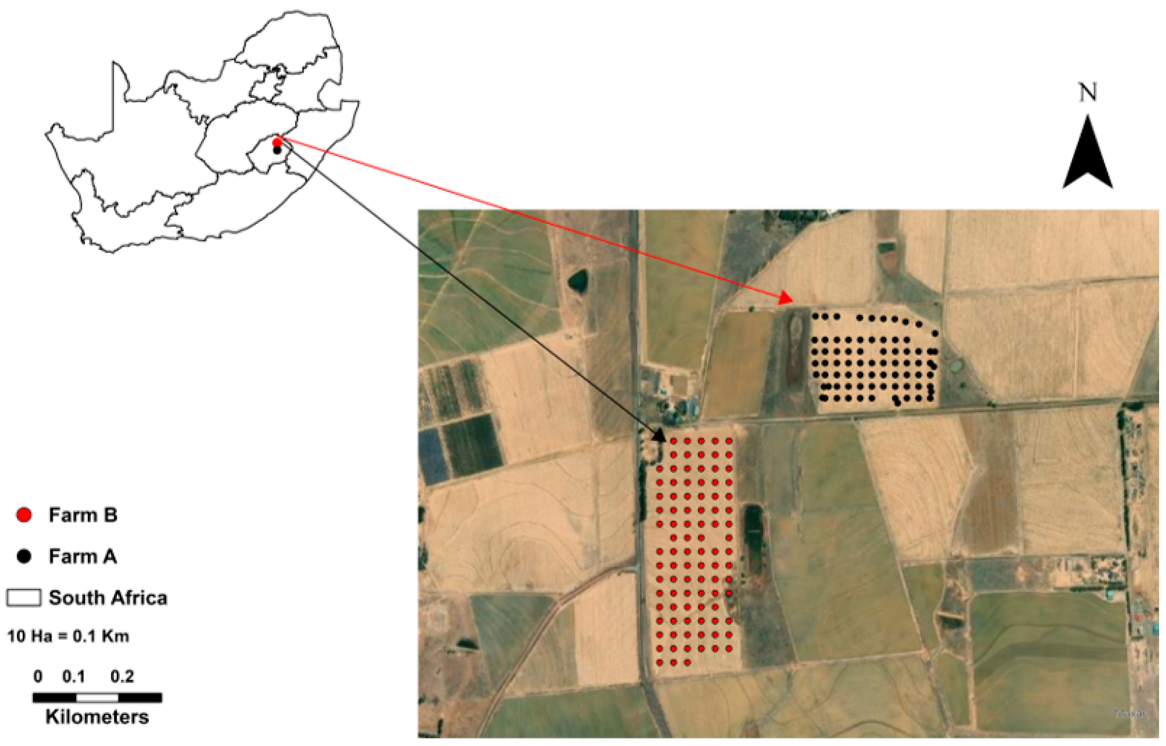
2.1. Study Area

The study was conducted in two winter wheat farms (Figure 1, farms A and B) that cover about 30 and 17 hectares, respectively. The farms are in Clarens, which is in the Thabo Mofutsanyane District Municipality, Free State Province, South Africa. The fertilizer application rate was 100 kg/ha of Cireun fertilizer with the ratio N:55:P:15:K:8, and the wheat cultivar was PAN: 3161. The PAN: 3161 is a winter wheat cultivar suitable for dryland production areas of the Free State Province.

2.2. Methodology

Figure 2 is a summary of the methodology used to investigate the performances of VIs and soil properties in the prediction of crop growth variability. The soil data were used to produce interpolated and continuous distribution maps. Additionally, the UAV data was used to compute VI distribution maps. Both the soil and VI datasets were used as input variables for predicting crop height (response variable). Datasets were split into 80% training and 20% testing for GRP and LSboost-Bag-ER models. The training and testing included a VI experiment scenario and an integration of VIs and soil properties. The accuracies of the models were evaluated using mean absolute error (MAE), root mean square error (RMSE), and coefficient of determination (R2).

2.3. UAV Camera Properties and Vegetation Indices Used in This Study

Table 1 presents the spectral band information of MicaSense RedEdge-MX multispectral sensor with wavelength (475–840nm) and bandwidth (20–40 nm). Table 2 summarizes the VIs generated using UAV imagery bands. Figure 3a shows a multi-rotor DJI-Matrice 600 Pro UAV with a MicaSense RedEdge-MX multispectral sensor. Figure 3b depicts calibration reflectance panel (CRP) with serial number: RP04-1918107-OB and constant laboratory CRP values ranging from 0.529 to 0.536, respectively.

3. Results

3.1. Correlation Matrix

Correlation analyses showed that soil properties, in particular Ca, Mg, K and clay, were more important than VIs in representing actual crop growth (Figure 4 and Figure 5). In addition, there was a high intra-field variability of soil properties in farm A and farm B. For instance, farm B Mg (r = 0.7), K (r = 0.61), and clay (r = 0.49) had a higher correlation with actual crop height than farm A Mg (r = 0.34), k (r = 0.33), and clay (r = 0.18), respectively.

3.2. Model Evaluation

The performance statistics of GPR and LSboost-Bag-ER are summarized in Table 3. The GPR (R2 = 0.68 to 0.75, RMSE = 15.85 to 18.38 cm) model performed better than LSboost-Bag-ER (R2 = 0.64 to 0.70 and RMSE = 17.26 to 19.34 cm) for both farms. Furthermore, GPR achieved the highest accuracy when soil properties and UAV-derived VI were combined. The standalone use of VI generated the lowest modelling accuracies.

4. Conclusions

This study investigated the performances of in-situ soil data and monthly UAV data in predicting intra-field crop growth variability in a winter wheat farm. Findings revealed that the standalone use of VIs, as well as the combined use of VIs and soil properties can accurately predict wheat height which was used as a proxy for crop growth. The key findings from this study are associated with the efficiency of the data fusion approach to enhance modelling precision and provide useful information about the influence of soil properties on the prediction of crop height growth. This study will benefit crop agronomic management and increase potential yields.

Author Contributions

Conceptualization, L.N. and C.M.; methodology; software and data pre-processing, L.N. and C.M; writing—original draft preparation, L.N.; writing—review and editing, C.M., J.G.C., A.M.K., Z.M.-M., W.M. and P.E.R.; supervision, J.G.C., C.M., A.M.K., Z.M.-M. and W.M. All authors have read and agreed to the published version of the manuscript.

Funding

This research was funded by the Council for Scientific and Industrial Research (CSIR) and the Department of Science and Innovation (DSI). Research support from the Agricultural Research Council-Natural Resources and Engineering (ARC-NRE), National Research Foundation (NRF) (grant number: TTK200221506319), and the South African National Space Agency (SANSA) are acknowledged.

Institutional Review Board Statement

Not applicable.

Informed Consent Statement

Not applicable.

Data Availability Statement

Data used in this study are available on request.

Acknowledgments

The authors would like to thank the Agricultural Research Council ARC-NRE and University of Pretoria for creating an enabling environment for research. We would also like to thank the following people for participating during the field campaigns: Cilence Munghemezulu, Eric Economon, Pisto Khoboko, Phathutshedzo Eugene Ratshiedana, and Wonga Masiza.

Conflicts of Interest

The authors declare no conflicts of interest.

References

  1. Nduku, L.; Munghemezulu, C.; Mashaba-Munghemezulu, Z.; Kalumba, A.M.; Chirima, G.J.; Masiza, W.; De Villiers, C. Global Research Trends for Unmanned Aerial Vehicle Remote Sensing Application in Wheat Crop Monitoring. Geomatics 2023, 3, 115–136. [Google Scholar] [CrossRef]
  2. EL Sabagh, A.; Islam, M.S.; Skalicky, M.; Ali Raza, M.; Singh, K.; Anwar Hossain, M.; Arshad, A. Salinity Stress in Wheat (Triticum Aestivum L.) in the Changing Climate: Adaptation and Management Strategies. Front. Agron. 2021, 3, 661932. [Google Scholar] [CrossRef]
  3. Goffart, D.; Dvorakova, K.; Crucil, G.; Curnel, Y.; Limbourg, Q.; Van Oost, K.; van Wesemael, B. UAV Remote Sensing for Detecting Within-Field Spatial Variation of Winter Wheat Growth and Links to Soil Properties and Historical Management Practices. A Case Study on Belgian Loamy Soil. Remote Sens. 2022, 14, 2806. [Google Scholar] [CrossRef]
  4. Skendžić, S.; Zovko, M.; Lešić, V.; Pajač Živković, I.; Lemić, D. Detection and Evaluation of Environmental Stress in Winter Wheat Using Remote and Proximal Sensing Methods and Vegetation Indices—A Review. Diversity 2023, 15, 481. [Google Scholar] [CrossRef]
  5. Upreti, D.; Huang, W.; Kong, W.; Pascucci, S.; Pignatti, S.; Zhou, X.; Casa, R. A Comparison of Hybrid Machine Learning Algorithms for the Retrieval of Wheat Biophysical Variables from Sentinel-2. Remote Sens. 2019, 11, 481. [Google Scholar] [CrossRef]
Figure 1. An overview of the Clarens wheat farms, and their location within the borders of Free State Province and South Africa.
Environsciproc 29 00024 g001
Figure 2. Methodology flowchart for intra-field crop growth modelling used in this study.
Environsciproc 29 00024 g002
Figure 3. Multi-rotor DJI-Matrice 600 Pro UAV (a) and Calibration Reflectance Panel serial number: RP04-1918107-OB (b).
Environsciproc 29 00024 g003
Figure 4. Farm A; Pearson correlation matrix of VIs and soil physical and chemical properties.
Environsciproc 29 00024 g004
Figure 5. Farm B; Pearson correlation matrix of VIs and soil physical and chemical properties.
Environsciproc 29 00024 g005
Table 1. Properties of UAV MicaSense RedEdge-MX series sensor.
BandsCenter Wavelength (nm)Band WidthCRP
Blue475200.536
Green560200.536
Red668100.534
RedEdge717100.529
Near Infrared (NIR)840400.533
Table 2. List of vegetation indices used in this study.
Vegetation IndicesFormulaReferences
Normalized Difference RedEdge Index (RENDI) N I R     R e d   E d g e N I R   +   R e d   E d g e [3,4]
Normalized Difference VegetationIndex (NDVI) N I R     R e d N I R   +   R e d [3,4]
Normalized Difference Index (NDI) R e d E d g e     R e d R e d E d g e   +   R e d [3,4]
Ratio Vegetation Index 2 (RVI2) R e d R e d E d g e [4]
Table 3. GPR and LSboost-Bag-ER model performance.
Wheat FarmsPredictor VariablesModelR2MAERMSE
Farm AVIsGPR0.7212.1116.63
VIs and soil propertiesGPR0.7511.4315.85
VIsLSboost-Bag-ER0.7012.5117.41
VIs and soil propertiesLSboost-Bag-ER0.7012.6517.26
Farm BVIsGPR0.6712.3818.63
VIs and soil propertiesGPR0.6812.7718.38
VIsLSboost-Bag-ER0.6412.6619.35
VIs and soil propertiesLSboost-Bag-ER0.6413.0219.34
Disclaimer/Publisher’s Note: The statements, opinions and data contained in all publications are solely those of the individual author(s) and contributor(s) and not of MDPI and/or the editor(s). MDPI and/or the editor(s) disclaim responsibility for any injury to people or property resulting from any ideas, methods, instructions or products referred to in the content.

