
Above the Ravines: Flood Vulnerability Assessment of Earthen Architectural Heritage in Quito (Ecuador)

 , , , and
Abstract
:1. Introduction
2. Materials and Methods
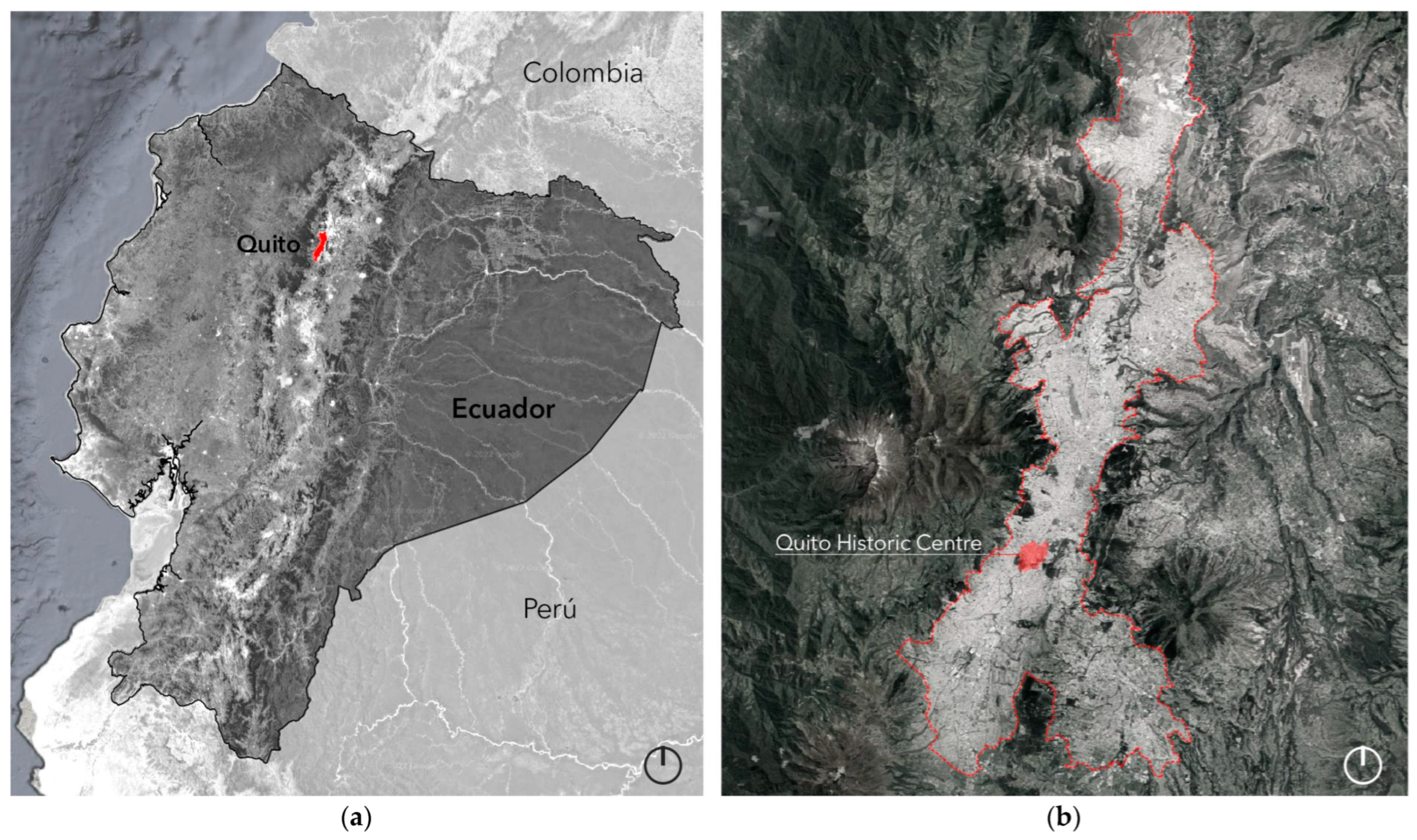
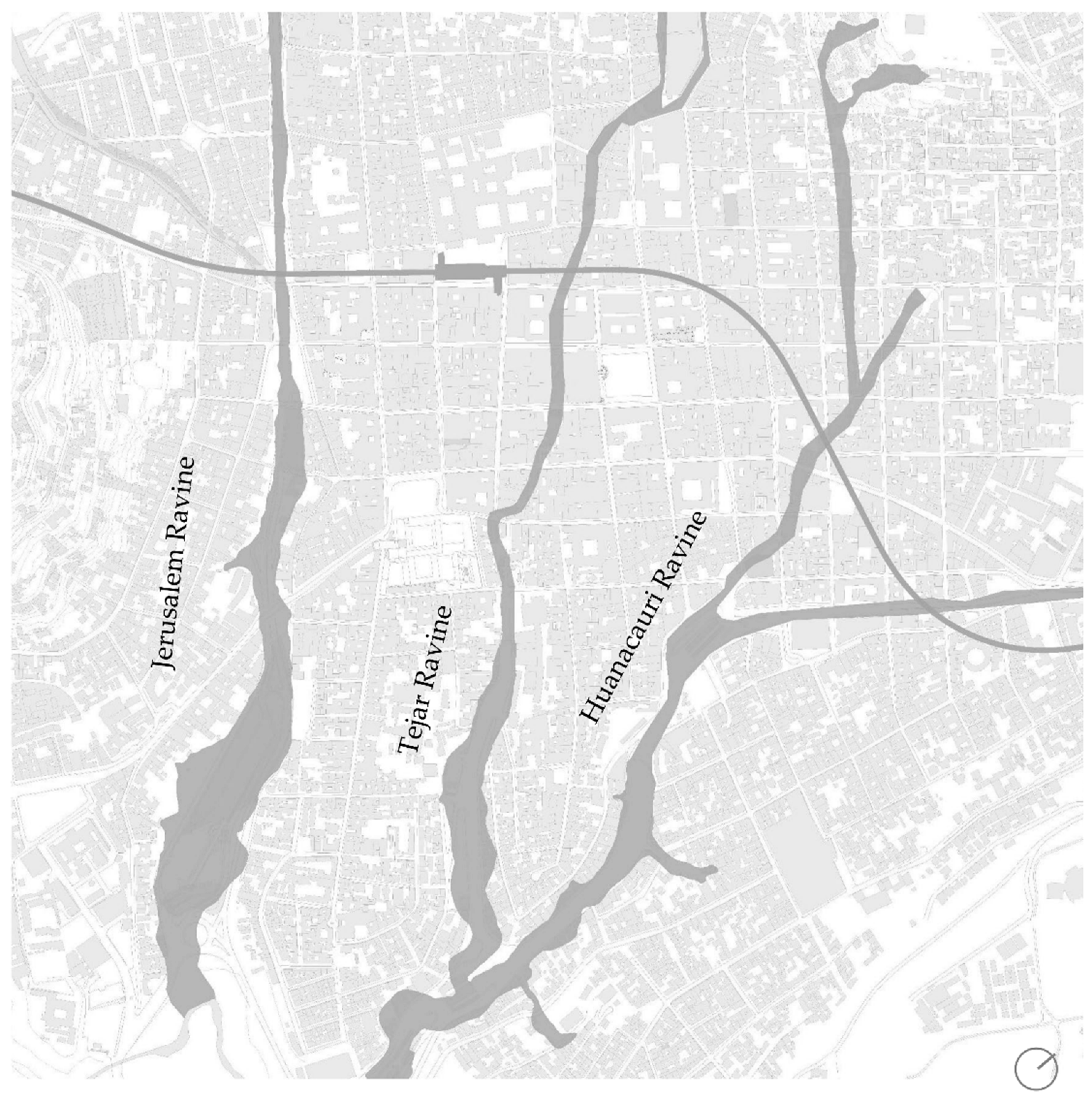
2.1. Research Area
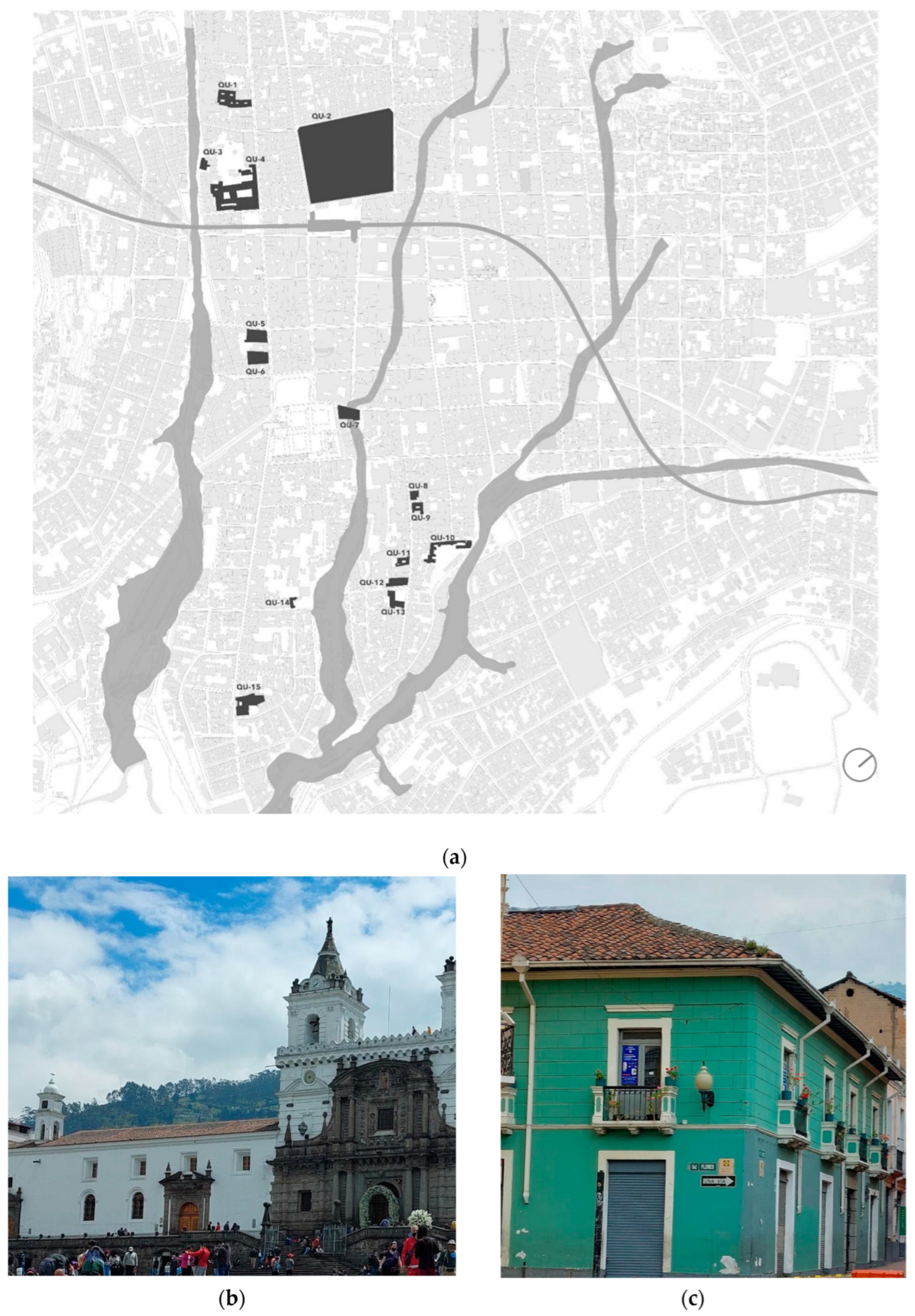
2.2. Cases Studies
2.3. Vulnerability Assessment
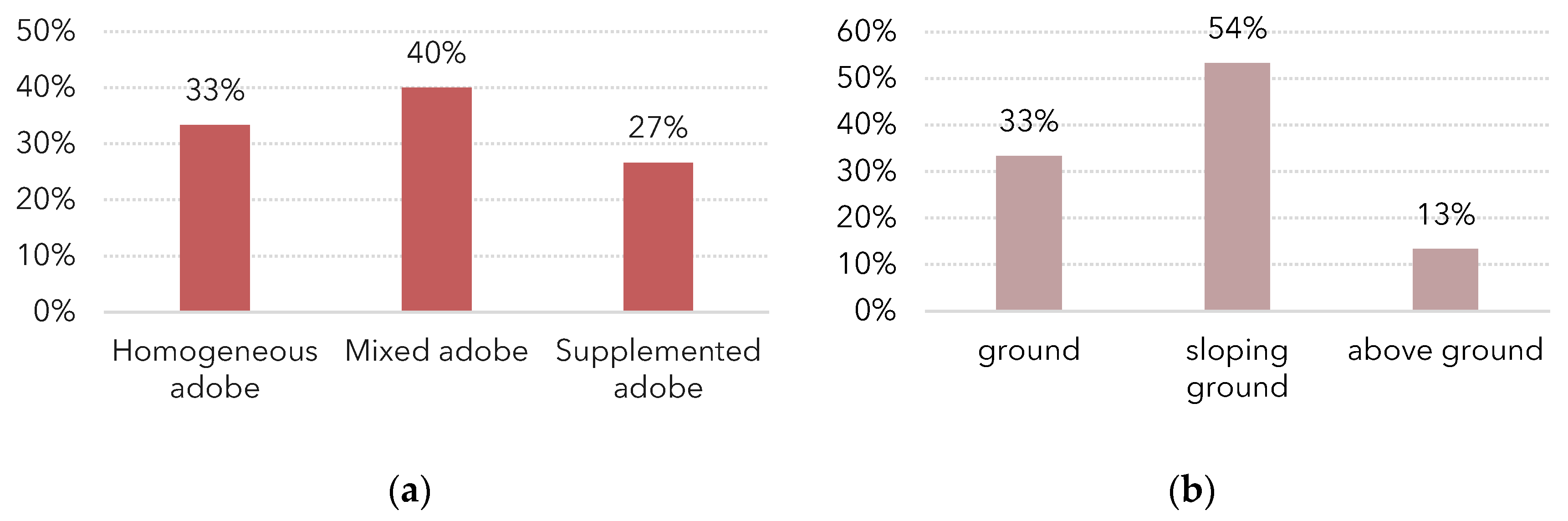
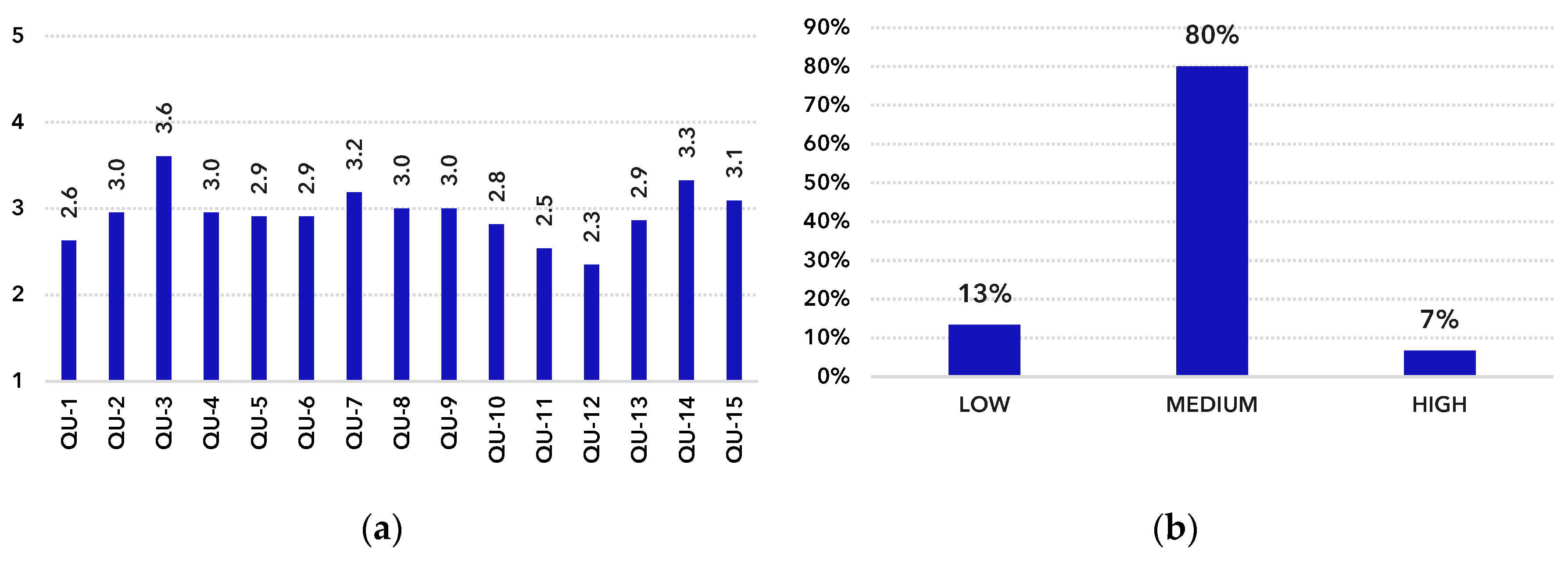
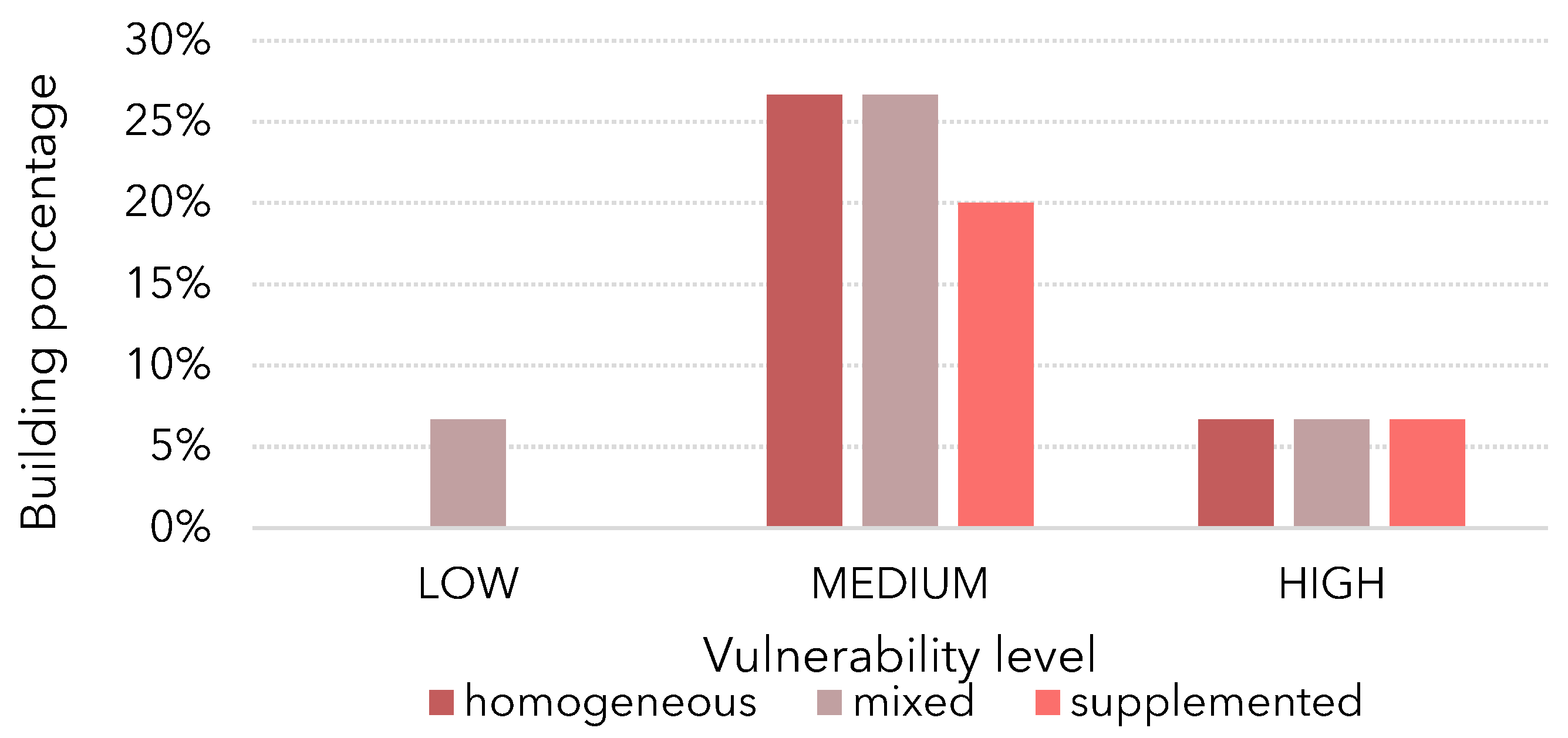
3. Results and Discussion
4. Conclusions
Author Contributions
Funding
Institutional Review Board Statement
Informed Consent Statement
Data Availability Statement
Conflicts of Interest
References
- Beckett, C.T.S.; Jaquin, P.A.; Morel, J.C. Weathering the storm: A framework to assess the resistance of earthen structures to water damage. Constr. Build. Mater. 2020, 242, 118098. [Google Scholar] [CrossRef]
- Gerard, P.; Mahdad, M.; Robert McCormack, A.; François, B. A unified failure criterion for unstabilized rammed earth materials upon varying relative humidity conditions. Constr. Build. Mater. 2015, 95, 437–447. [Google Scholar] [CrossRef]
- Herle, I.; Herbstová, V.; Kupka, M.; Kolymbas, D. Geotechnical Problems of Cultural Heritage due to Floods. J. Perform. Constr. Facil. 2010, 24, 446–451. [Google Scholar] [CrossRef]
- Drdácký, M.F. Flood Damage to Historic Buildings and Structures. J. Perform. Constr. Facil. 2010, 24, 439–445. [Google Scholar] [CrossRef]
- United Nations. Sendai Framework for Disaster Risk Reduction 2015–2030; United Nations: Sendai, Japan, 2015. [Google Scholar]
- Galasso, C.; Pregnolato, M.; Parisi, F. A model taxonomy for flood fragility and vulnerability assessment of buildings. Int. J. Disaster Risk Reduct. 2021, 53, 14. [Google Scholar] [CrossRef]
- Merz, B.; Kreibich, H.; Lall, U. Multi-variate flood damage assessment: A tree-based data-mining approach. Nat. Hazards Earth Syst. Sci. 2013, 13, 53–64. [Google Scholar] [CrossRef]
- Messner, F.; Penning-rowsell, E.; Green, C.; Tunstall, S.; Van Der Veen, A.; Tapsell, S.; Wilson, T.; Krywkow, J.; Logtmeijer, C.; Fernández-bilbao, A.; et al. Evaluating Flood Damages: Guidance and Recommendations on Principles and Methods. 2007. Available online: http://www.floodsite.net/html/partner_area/project_docs/T09_06_01_Flood_damage_guidelines_d9_1_v2_2_p44.pdf (accessed on 3 February 2022).
- Harrer, A. The Legacy of Alois Riegl: Material Authenticity of the Monument in the Digital Age. Built Herit. 2017, 1, 29–40. [Google Scholar] [CrossRef]
- Díez-Herrero, A.; Garrote, J. Flood risk assessments: Applications and uncertainties. Water 2020, 12, 2096. [Google Scholar] [CrossRef]
- Dassanayake, D.R.; Burzel, A.; Oumeraci, H. Methods for the evaluation of intangible flood losses and their integration in flood risk analysis. Coast. Eng. J. 2015, 57, 1–36. [Google Scholar] [CrossRef]
- Stephenson, V.; D’Ayala, D. A new approach to flood vulnerability assessment for historic buildings in England. Nat. Hazards Earth Syst. Sci. 2014, 14, 1035–1048. [Google Scholar] [CrossRef]
- Figueiredo, R.; Romão, X.; Paupério, E. Flood risk assessment of cultural heritage at large spatial scales: Framework and application to mainland Portugal. J. Cult. Herit. 2020, 43, 163–174. [Google Scholar] [CrossRef]
- Romão, X.; Paupério, E.; Pereira, N. A framework for the simplified risk analysis of cultural heritage assets. J. Cult. Herit. 2016, 20, 696–708. [Google Scholar] [CrossRef] [Green Version]
- Arrighi, C. A Global Scale Analysis of River Flood Risk of UNESCO World Heritage Sites. Front. Water 2021, 3, 192. [Google Scholar] [CrossRef]
- Figueiredo, R.; Romão, X.; Paupério, E. Component-based flood vulnerability modelling for cultural heritage buildings. Int. J. Disaster Risk Reduct. 2021, 61, 102323. [Google Scholar] [CrossRef]
- Trizio, F.; Torrijo, F.J.; Mileto, C.; Vegas, F. Flood Risk in a Heritage City: Alzira as a Case Study. Water 2021, 13, 1138. [Google Scholar] [CrossRef]
- Moreno, M.; Ortiz, P.; Ortiz, R. Vulnerability study of earth walls in urban fortifications using cause-effect matrixes and gis: The case of seville, carmona and estepa defensive fences. Mediterr. Archaeol. Archaeom. 2019, 19, 119–138. [Google Scholar] [CrossRef]
- Canivell, J.; Rodríguez-García, R.; González-Serrano, A.; Romero-Girón, A. Assessment of Heritage Rammed-Earth Buildings: Alcázar of King Don Pedro I, Spain. J. Archit. Eng. 2020, 26, 05020003. [Google Scholar] [CrossRef]
- Richards, J.; Wang, Y.; Orr, S.A.; Viles, H. Finding common ground between United Kingdom based and Chinese approaches to earthen heritage conservation. Sustainability 2018, 10, 3086. [Google Scholar] [CrossRef] [Green Version]
- Du, Y.; Chen, W.; Cui, K.; Zhang, K. Study on Damage Assessment of Earthen Sites of the Ming Great Wall in Qinghai Province Based on Fuzzy-AHP and AHP-TOPSIS. Int. J. Archit. Herit. 2020, 14, 903–916. [Google Scholar] [CrossRef]
- Morel, J.C.; Bui, Q.B.; Hamard, E. Weathering and durability of earthen material and structures. In Modern Earth Buildings: Materials, Engineering, Constructions and Applications; Woodhead Publishing: Sawston, UK, 2012; pp. 282–303. [Google Scholar] [CrossRef]
- Xu, L.; Wong, K.K.; Fabbri, A.; Champiré, F.; Branque, D. Loading-unloading shear behavior of rammed earth upon varying clay content and relative humidity conditions. Soils Found. 2018, 58, 1001–1015. [Google Scholar] [CrossRef]
- Beckett, C.T.S.; Augarde, C.E.; Easton, D.; Easton, T. Strength characterisation of soil-based construction materials. Geotechnique 2018, 68, 400–409. [Google Scholar] [CrossRef] [Green Version]
- Ortiz Crespo, A. (Ed.) Ciudad de Quito. Guía de Arquitectura. Volumes I–II; Junta de Andalucía: Quito, Ecuador, 2004.
- Peltre, P. Quebradas y Riesgos Naturales en Quito, Periodo 1900–1988; Corporación Editora Nacional: Quito, Ecuador, 1989. [Google Scholar]
- Terán, A.; Salazar, D. (Eds.) Atlas de Amenazas Naturales y Exposición de Infraestructura del Distrito Metropolitano de Quito, Segunda ed.; Quito, Ecuador, 2015. Available online: https://www.quito.gob.ec/index.php/rendicion-de-cuentas/218-atlas-amenazas-naturales-dmq (accessed on 5 May 2022).
- Bracchi, P.; Torrijo, F.J.; Boix, A.; Cruz Cabrera, M.; Giordanelli, D. Urban and hydrogeological alert on the morphoclimatic risk affecting quito’s world heritage. Int. Arch. Photogramm. Remote Sens. Spat. Inf. Sci.-ISPRS Arch. 2020, 54, 825–832. [Google Scholar] [CrossRef]
- Instituto Metropolitano de Patrimonio. Diagnóstico Centro Histórico de Quito; Instituto Metropolitano de Patrimonio: Quito, Ecuador, 2017.
- Servicio Nacional de Gestión de Riesgos y Emergencia. Informes de Situación–Aluvión Quito, La Gasca (31/01/2022). Available online: https://www.gestionderiesgos.gob.ec/informes-de-situacion-aluvion-quito-la-gasca-31-01-2022/ (accessed on 4 June 2022).
- UNESCO. 36th Session Records of the General Conference: Recommendation of Historic Urban Landscape. Paris, 25 October–10 November 2011, Volume 1: Resolutions. pp. 50–55. 2012. Available online: https://unesdoc.unesco.org/ark:/48223/pf0000215084?posInSet=4&queryId=196496b5-26e2-4a84-90cd-d914cf0e0596 (accessed on 4 June 2022).
- Mileto, C.; Vegas, F.; García, L.; Pérez, A. Assessment of Vulnerability of Earthen Vernacular Architecture in the Iberian Peninsula to Natural Risks. Generation of an Analysis Tool. Int. J. Archit. Herit. 2021, 16, 885–898. [Google Scholar] [CrossRef]
- Trizio, F.; Torrijo Echarri, F.J.; Mileto, C.; Vegas López-Manzanares, F. Flood vulnerability and damage assessment of earthen architectural heritage of the Iberian Peninsula. In Geotechnical Engineering for the Preservation of Monuments and Historic Sites III; CRC Press: Boca Raton, FL, USA, 2022; pp. 1067–1078. [Google Scholar] [CrossRef]
- Instituto Metropolitano de Patrimonio (IMP). Plan De Gestión Del Riesgo de Desastres Para el Núcleo Central del Centro Histórico de Quito, Patrimonio Mundial; Instituto Metropolitano de Patrimonio (IMP): Quito, Ecuador, 2021.
- Baez, E.; De Sutter, P.; Isch, A.; Naranjo, F.; Ribadeneira, A. (Eds.) Proyecto Piloto de Rehabilitación Arquitectónica y Urbana. Barrios San Marcos, La Chilena y Eje Calle Chile; Universidad Central del Ecuador-FAU: Quito, Ecuador, 1999. [Google Scholar]
- Andrade, R.; Borja, K.; Checa, G.; Díaz Navarrete, G.; Fernandez-Salvador, C.; Gallegos, L.; Navarrete, B.; Pazmiño, R.; Paredes, D.; Pérez Arteta, J.F.; et al. Centro Historico de Quito: La vivienda; Peralta, E., Carrión, F., Gonzalez Tamarit, L., Román Ruiz, J., Eds.; Editorial Fraga: Quito, Ecuador, 1991. [Google Scholar]
- Nakhaei, M.; Correia, M. Water-risk management in Tchogha Zanbil world heritage site in Iran, with a focus on the ancient management system. In International Archives of the Photogrammetry, Remote Sensing and Spatial Information Sciences-ISPRS Archives; Mileto, C., Vegas., F., Cristini, V., García, L., Eds.; ISPRS: Valencia, Spain, 2020; Volume 54, pp. 683–690. [Google Scholar] [CrossRef]
- Taylor, J.R. An Introduction to Error Analysis, 2nd ed.; University of Science Books: Sausalito, CA, USA, 1982. [Google Scholar]
- de Moel, H.; Jongman, B.; Kreibich, H.; Merz, B.; Penning-Rowsell, E.; Ward, P.J. Flood risk assessments at different spatial scales. Mitig. Adapt. Strateg. Glob. Chang. 2015, 20, 865–890. [Google Scholar] [CrossRef] [PubMed] [Green Version]
- Garrote, J.; González-Jiménez, M.; Guardiola-Albert, C.; Díez-Herrero, A. The manning’s roughness coefficient calibration method to improve flood hazard analysis in the absence of river bathymetric data: Application to the urban historical zamora city centre in spain. Appl. Sci. 2021, 11, 9267. [Google Scholar] [CrossRef]
- Lastrada, E.; Cobos, G.; Torrijo, F.J. Analysis of climate change’s effect on flood risk. Case study of Reinosa in the Ebro river Basin. Water 2020, 12, 1114. [Google Scholar] [CrossRef] [Green Version]
- Ortiz, R.; Ortiz, P. Vulnerability Index: A New Approach for Preventive Conservation of Monuments. Int. J. Archit. Herit. 2016, 10, 1078–1100. [Google Scholar] [CrossRef]


| Code | Building | Type |
|---|---|---|
| QU-1 | Casa de los Siete Patios | Residential/Commercial |
| QU-2 | Church and Convent of San Francisco | Religious |
| QU-3 | Capilla del Robo | Religious |
| QU-4 | Monastery of Santa Clara | Religious |
| QU-5 | Casa de Luis Robalino Dávila | Residential/Commercial |
| QU-6 | Casa Ponce | Residential/Commercial |
| QU-7 | Casa del Puente de Manosalvas | Residential/Commercial |
| QU-8 | Museo Arquitectura Ecuatoriana (MAE) | Residential/Cultural |
| QU-9 | Casa Ortiz Bilbao | Residential/Administrative |
| QU-10 | Colectiva Almeida | Residential |
| QU-11 | Casa de Mathias Abrams | Residential |
| QU-12 | Casa de la Fundación Caspicara | Residential/Institutional |
| QU-13 | Church of San Marcos | Religious |
| QU-14 | Capilla de los Milagros | Religious |
| QU-15 | Mama Cuchara Cultural Centre | Residential/Cultural |
| Characteristic | W | SF | Characteristic | W | SF |
|---|---|---|---|---|---|
| Urban location | 0.8 | Construction technique | 0.6 | ||
| 5 |
| 1 | ||
| 4 |
| 3 | ||
| 3 |
| 5 | ||
| 1 | ||||
| 3 | ||||
| Footprint [m2] | 0.4 | Variants of the construction technique | 0.6 | ||
| 5 |
| 1 | ||
| 3 |
| 3 | ||
| 1 |
| 5 | ||
| Floors | 0.4 |
| 5 | ||
| 1 |
| 3 | ||
| 3 |
| 1 | ||
| 5 |
| 5 | ||
| 1 | ||||
| Building type | 0.4 | Plinth | 0.7 | ||
| 5 |
| 5 | ||
| 4 |
| 3 | ||
| 3 |
| 1 | ||
| 1 |
| 2 | ||
| Additional protection | 0.5 | Rendering | 0.5 | ||
| 1 |
| 5 | ||
| 5 |
| 4 | ||
| 2 | ||||
| 3 | ||||
| 1 | ||||
| 3 |
| Damages | W | SF |
|---|---|---|
| Wall erosion | 0.7 | |
| 1 | |
| 2 | |
| 3 | |
| 4 | |
| 5 | |
| Rendering erosion | 0.5 | |
| 1 | |
| 2 | |
| 3 | |
| 4 | |
| 5 | |
| Plinth erosion | 1 | |
| 1 | |
| 3 | |
| 4 | |
| 5 | |
| Structural damages | 1 | |
| 1 | |
| 3 | |
| 4 | |
| 5 | |
| Rising damp | 0.6 | |
| 1 | |
| 5 | |
| Wall saturation | 0.8 | |
| 1 | |
| 5 |
Publisher’s Note: MDPI stays neutral with regard to jurisdictional claims in published maps and institutional affiliations. |
© 2022 by the authors. Licensee MDPI, Basel, Switzerland. This article is an open access article distributed under the terms and conditions of the Creative Commons Attribution (CC BY) license (https://creativecommons.org/licenses/by/4.0/).
Share and Cite
Trizio, F.; Garzón-Roca, J.; Eguibar, M.Á.; Bracchi, P.; Torrijo, F.J. Above the Ravines: Flood Vulnerability Assessment of Earthen Architectural Heritage in Quito (Ecuador). Appl. Sci. 2022, 12, 11932. https://doi.org/10.3390/app122311932
Trizio F, Garzón-Roca J, Eguibar MÁ, Bracchi P, Torrijo FJ. Above the Ravines: Flood Vulnerability Assessment of Earthen Architectural Heritage in Quito (Ecuador). Applied Sciences. 2022; 12(23):11932. https://doi.org/10.3390/app122311932
Chicago/Turabian StyleTrizio, Francesca, Julio Garzón-Roca, Miguel Ángel Eguibar, Paola Bracchi, and Francisco Javier Torrijo. 2022. "Above the Ravines: Flood Vulnerability Assessment of Earthen Architectural Heritage in Quito (Ecuador)" Applied Sciences 12, no. 23: 11932. https://doi.org/10.3390/app122311932