Recent Crown Thinning in a Boreal Black Spruce Forest Does Not Reduce Spread Rate nor Total Fuel Consumption: Results from an Experimental Crown Fire in Alberta, Canada

 , , , , , , and
Abstract
:1. Introduction
2. Materials and Methods
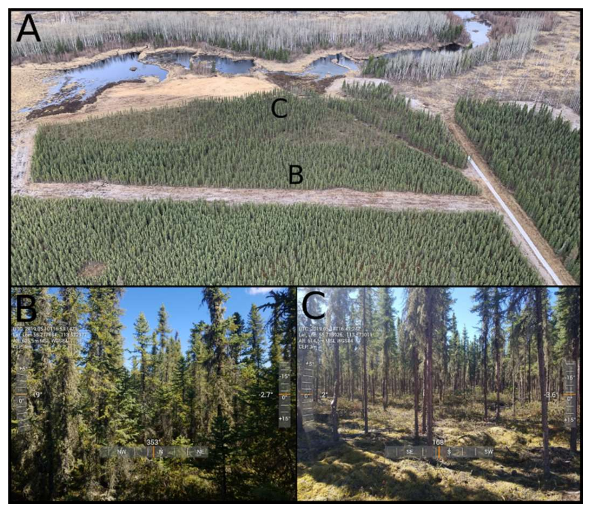
2.1. Site Description
2.2. Canopy Height and Fuel Loading
2.3. Weather and Fuel Moisture
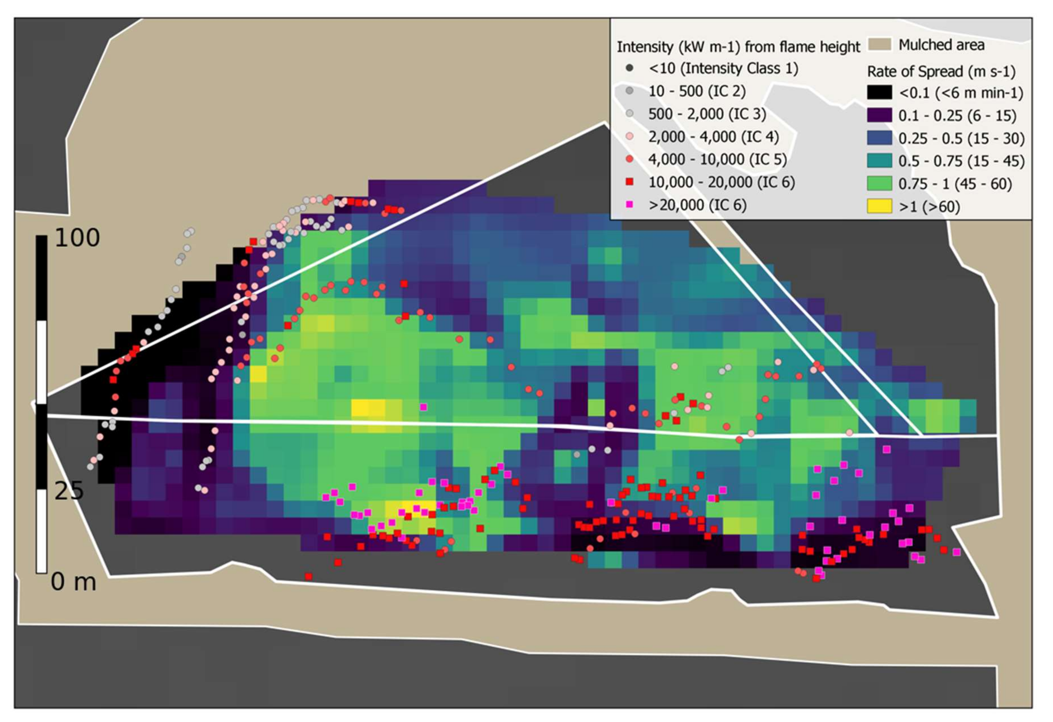
2.4. Ground Observations of Fire Spread and Intensity
2.5. Aerial Observations of Fire Spread and Intensity
3. Results
3.1. Fuel Loading
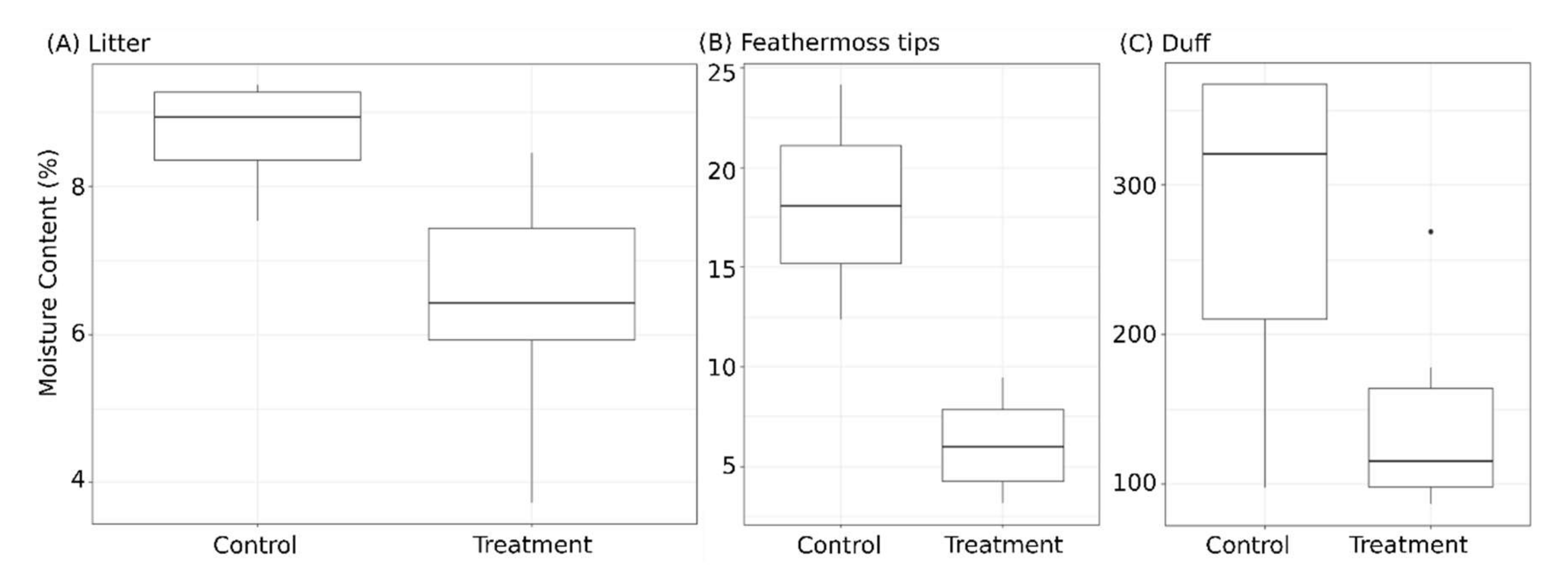
3.2. Fuel Moisture
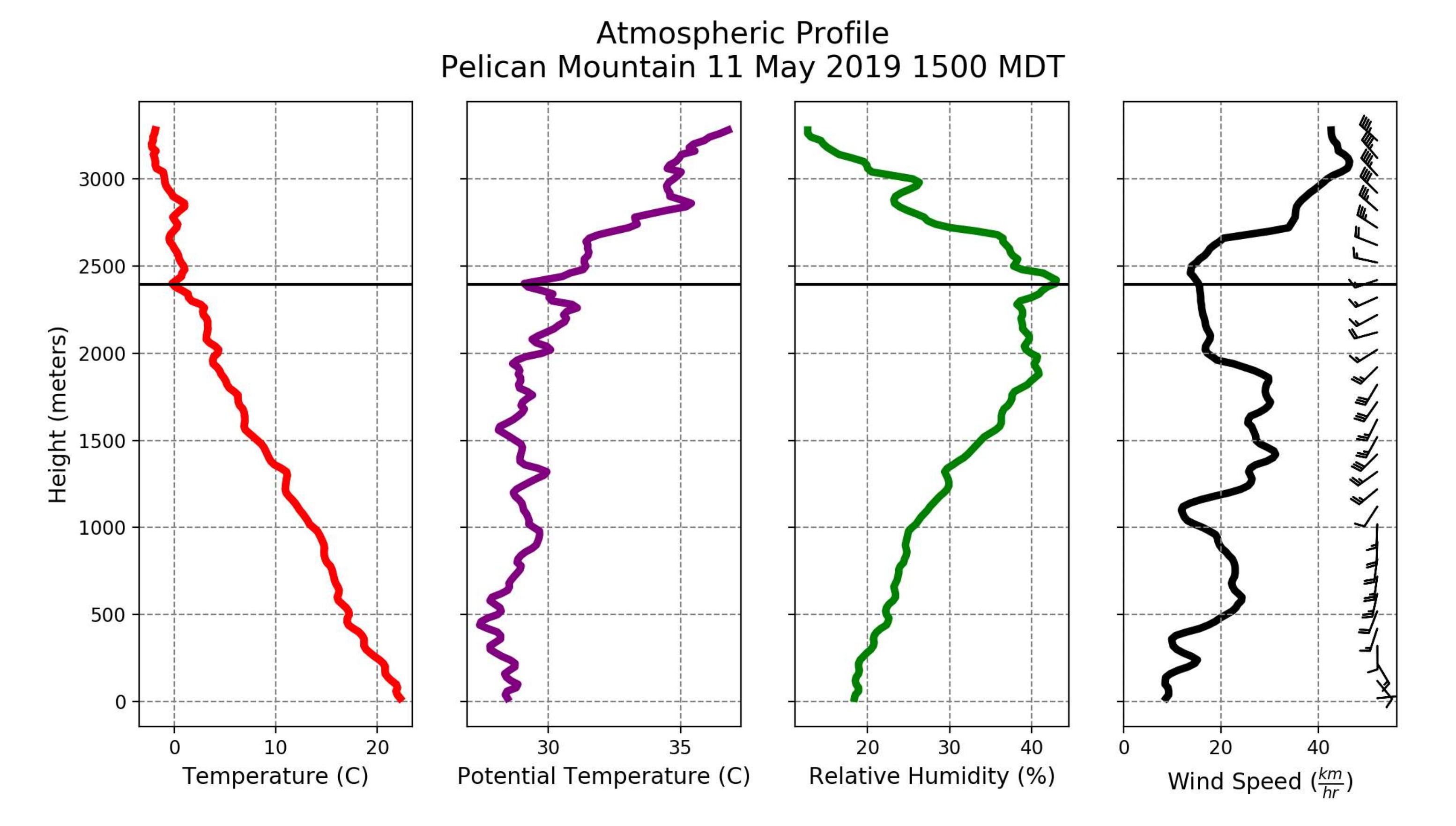
3.3. Fire Weather and Atmosphere
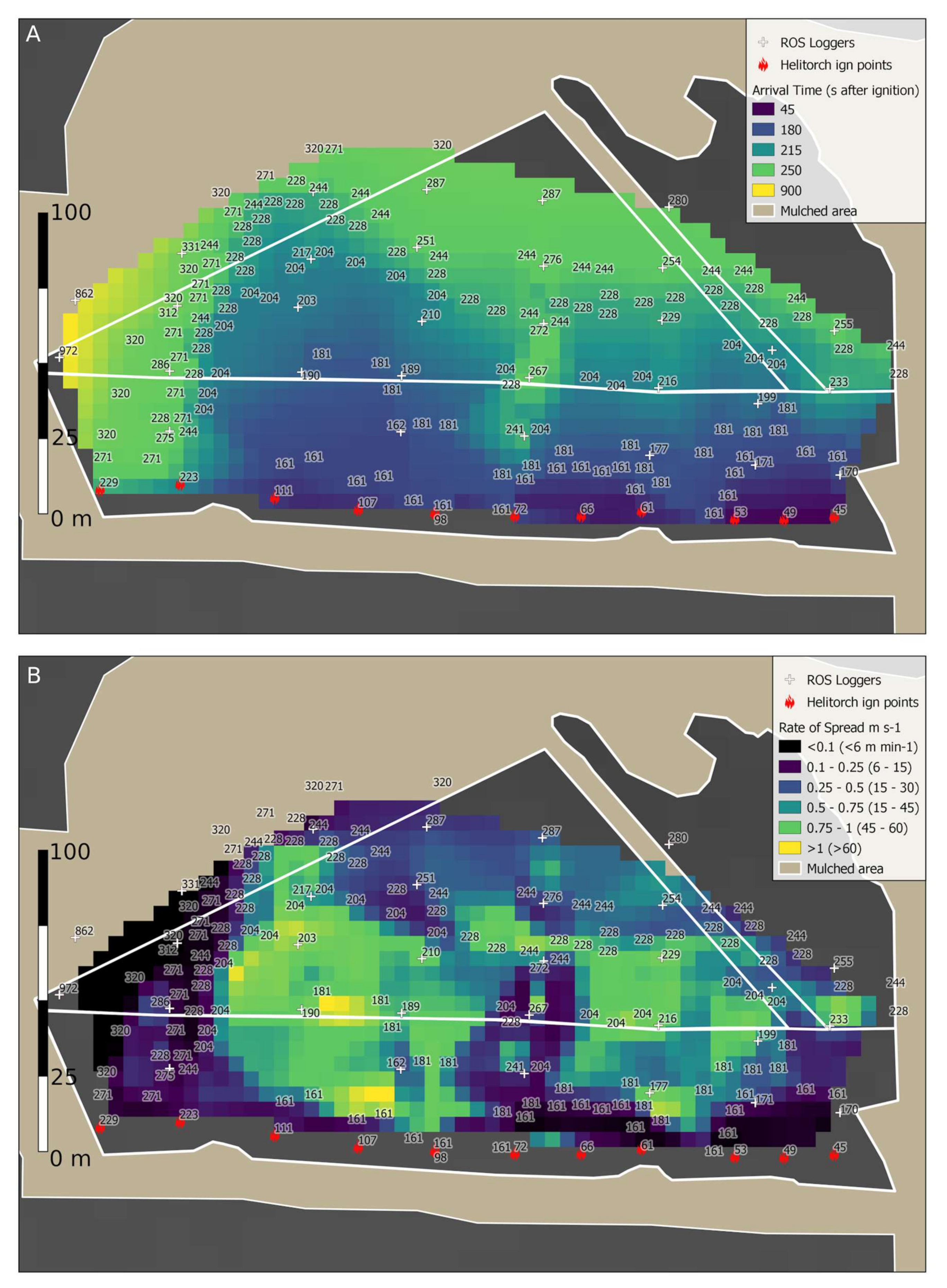
3.4. Ignition and Spread Rate
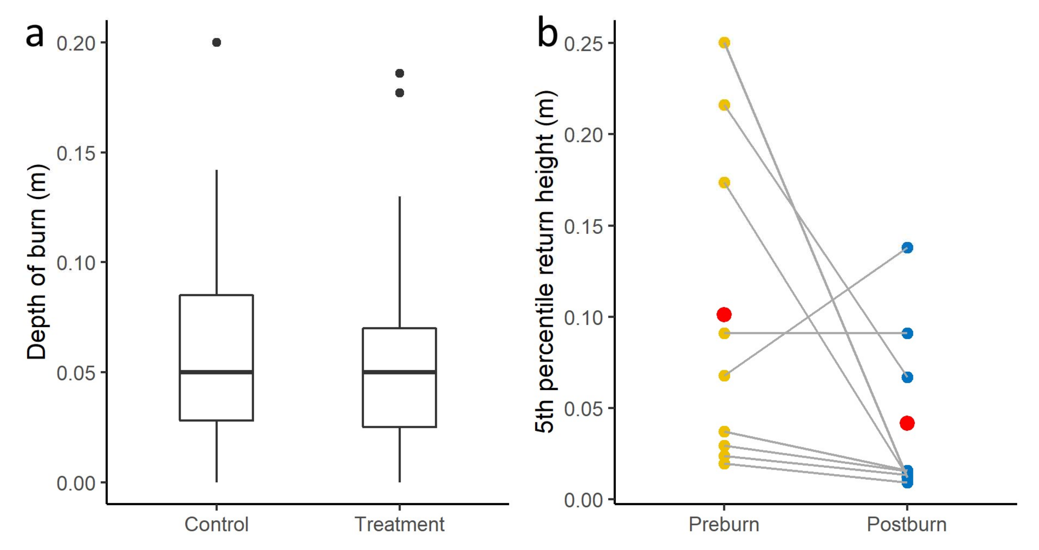
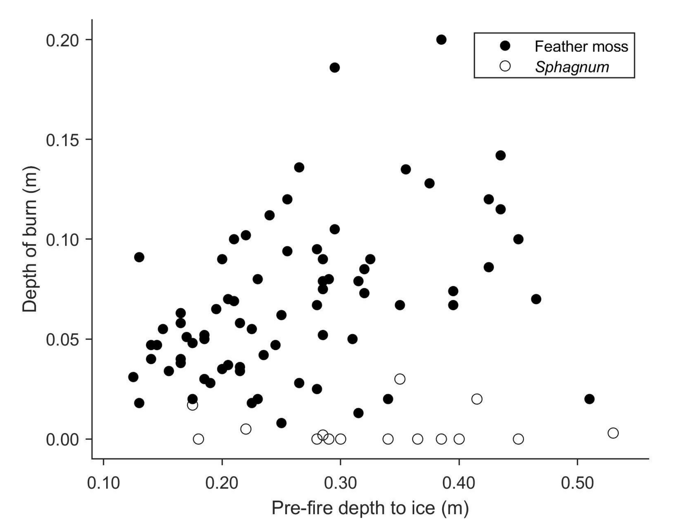
3.5. Fuel Consumption and Fire Intensity
4. Discussion
4.1. Contrasts with Other Experimental Fires
4.2. Fuel Moisture Considerations in Thinned Stands
4.3. Seasonally Frozen Organic Soils
4.4. Evidence for Fire Intensity Changes
4.5. Inferring Rate of Spread from Combined Aerial and Ground Data
5. Conclusions
Supplementary Materials
Author Contributions
Funding
Acknowledgments
Conflicts of Interest
Data Availability
References
- Syphard, A.D.; Keeley, J.E. Factors Associated with Structure Loss in the 2013–2018 California Wildfires. Fire 2019, 2, 49. [Google Scholar] [CrossRef] [Green Version]
- Alexandre, P.M.; Stewart, S.I.; Keuler, N.S.; Clayton, M.K.; Mockrin, M.H.; Bar-Massada, A.; Syphard, A.D.; Radeloff, V.C. Factors related to building loss due to wildfires in the conterminous United States. Ecol. Appl. 2016, 26, 2323–2338. [Google Scholar] [CrossRef] [PubMed]
- Boer, M.M.; Sadler, R.J.; Wittkuhn, R.S.; McCaw, L.; Grierson, P.F. Long-term impacts of prescribed burning on regional extent and incidence of wildfires—Evidence from 50 years of active fire management in SW Australian forests. Ecol. Manag. 2009, 259, 132–142. [Google Scholar] [CrossRef]
- Parsons, R.A.; Pimont, F.; Wells, L.; Cohn, G.; Jolly, W.M.; de Coligny, F.; Rigolot, E.; Dupuy, J.-L.; Mell, W.; Linn, R.R. Modeling thinning effects on fire behavior with STANDFIRE. Ann. Sci. 2018, 75, 7. [Google Scholar] [CrossRef] [Green Version]
- Whitman, E.; Parisien, M.-A.; Thompson, D.K.; Hall, R.J.; Skakun, R.S.; Flannigan, M.D. Variability and drivers of burn severity in the northwestern Canadian boreal forest. Ecosphere 2018, 9, e02128. [Google Scholar] [CrossRef] [Green Version]
- Cruz, M.G.; Alexander, M.E.; Wakimoto, R.H. Modeling the Likelihood of Crown Fire Occurrence in Conifer Forest Stands. Science 2004, 50, 640–658. [Google Scholar] [CrossRef]
- Wotton, B.M.; Beverly, J.L. Stand-specific litter moisture content calibrations for the Canadian Fine Fuel Moisture Code. Int. J. Wildland Fire 2007, 16, 463–472. [Google Scholar] [CrossRef]
- Thompson, D.K.; Studens, J.; Krezek-Hanes, C.; Wotton, B.M. The impact of root exclusion on duff moisture and fire danger. Can. J. Res. 2015, 45, 978–986. [Google Scholar] [CrossRef]
- Williams, T.G.; Flanagan, L.B. Effect of changes in water content on photosynthesis, transpiration and discrimination against 13CO2 and C18O16O in Pleurozium and Sphagnum. Oecologia 1996, 108, 38–46. [Google Scholar] [CrossRef] [PubMed]
- Prat-Guitart, N.; Rein, G.; Hadden, R.M.; Belcher, C.M.; Yearsley, J.M. Propagation probability and spread rates of self-sustained smouldering fires under controlled moisture content and bulk density conditions. Int. J. Wildland Fire 2016, 25, 456–465. [Google Scholar] [CrossRef] [Green Version]
- Jandt, R.; Barnes, J.L.; Horschel, E. Forest Floor Moisture Content and Fire Danger Indices in Alaska; U.S. Bureau of Land Management: Washington, DC, USA, 2005. [Google Scholar]
- Hirsch, K.G.; Corey, P.N.; Martell, D.L. Using Expert Judgment to Model Initial Attack Fire Crew Effectiveness. Science 1998, 44, 539–549. [Google Scholar] [CrossRef]
- Hirsch, K.G.; Podur, J.J.; Janser, R.F.; McAlpine, R.S.; Martell, D.L. Productivity of Ontario initial-attack fire crews: Results of an expert-judgement elicitation study. Can. J. Res. 2004, 34, 705–715. [Google Scholar] [CrossRef]
- Ponto, R.L. Bulldozer Production Rates and Guidelines for Constructing Fireguard in Boreal Forest Covertypes; Canada-Alberta Forest Resource Development Agreement; Forestry Canada: Edmonton, AB, Canada, 1989; ISBN 0-662-17140-3. [Google Scholar]
- Agee, J.K.; Bahro, B.; Finney, M.A.; Omi, P.N.; Sapsis, D.B.; Skinner, C.N.; van Wagtendonk, J.W.; Phillip Weatherspoon, C. The use of shaded fuelbreaks in landscape fire management. Ecol. Manag. 2000, 127, 55–66. [Google Scholar] [CrossRef]
- Campbell, M.J.; Page, W.G.; Dennison, P.E.; Butler, B.W. Escape Route Index: A Spatially-Explicit Measure of Wildland Firefighter Egress Capacity. Fire 2019, 2, 40. [Google Scholar] [CrossRef] [Green Version]
- Miller, E.A.; Barnes, D.E. Research Summary: Quantification of Sprinkler Effects in Alaskan Feathermoss Fuel Beds; Alaska Fire Science Consortium: Fairbanks, AK, USA, 2018; p. 6. [Google Scholar]
- Schroeder, D. Fire Behaviour in Thinned Jack Pine: Two Case Studies of FireSmart Treatments in Canada’s Northwest Territories; FP Innovations: Vancouver, BC, Canada, 2010; p. 12. [Google Scholar]
- Butler, B.W.; Ottmar, R.D.; Rupp, T.S.; Jandt, R.; Miller, E.; Howard, K.; Schmoll, R.; Theisen, S.; Vihnanek, R.E.; Jimenez, D. Quantifying the effect of fuel reduction treatments on fire behavior in boreal forests. Can. J. Res. 2012, 43, 97–102. [Google Scholar] [CrossRef]
- Mooney, C. Can Light Stand Thinning Weaken an Advancing Crown Fire? A Case Study in Black Spruce (Picea mariana); FP Innovations: Hinton, AB, Canada, 2013. [Google Scholar]
- Harris, C.; Fremont, L.; Price, O.; Boehr, W. 14LA-Lagoon Fire Case Study: How Fuel Treatment Areas Affect Wildland Urban Interface Areas; Government of Saskatchewan: Prince Albert, SK, Canada, 2015. [Google Scholar]
- Fromm, M.; Lindsey, D.T.; Servranckx, R.; Yue, G.; Trickl, T.; Sica, R.; Doucet, P.; Godin-Beekmann, S. The Untold Story of Pyrocumulonimbus. Bull. Am. Meteorol. Soc. 2010, 91, 1193–1210. [Google Scholar] [CrossRef] [Green Version]
- Benscoter, B.W.; Wieder, R.K. Variability in organic matter lost by combustion in a boreal bog during the 2001 Chisholm fire. Can. J. Res. 2003, 33, 2509–2513. [Google Scholar] [CrossRef]
- Erni, S.S.; Wang, X.; Taylor, S.; Boulanger, Y.; Swystun, T.; Flannigan, M.; Parisien, M.-A. Developing a two-level fire regime zonation system for Canada. Can. J. Res. 2019. [Google Scholar] [CrossRef]
- McGee, T.; McFarlane, B.; Tymstra, C. Chapter 3—Wildfire: A Canadian Perspective. In Wildfire Hazards, Risks and Disasters; Shroder, J.F., Paton, D., Eds.; Elsevier: Oxford, UK, 2015; pp. 35–58. ISBN 978-0-12-410434-1. [Google Scholar]
- McGaughey, R.J. FUSION/LDV: Software for LIDAR Data Analysis and Visualization. 2020, p. 217. Available online: http://forsys.sefs.uw.edu/software/fusion/FUSION_manual.pdf (accessed on 30 May 2020).
- Alexander, M.E.; Stefner, C.N.; Mason, J.A.; Stocks, B.J.; Hartley, G.R.; Maffey, M.E.; Wotton, B.M.; Taylor, S.W.; Lavoie, N.; Dalrymple, G.N. Characterizing the jack pine-black spruce fuel complex of the International Crown Fire Modelling Experiment (ICFME); Information Report; Canadian Forest Service: Edmonton, AB, Canada, 2004; ISBN 0-662-37422-3. [Google Scholar]
- Lukenbach, M.C.; Hokanson, K.J.; Devito, K.J.; Kettridge, N.; Petrone, R.M.; Mendoza, C.A.; Granath, G.; Waddington, J.M. Post-fire ecohydrological conditions at peatland margins in different hydrogeological settings of the Boreal Plain. J. Hydrol. 2017, 548, 741–753. [Google Scholar] [CrossRef]
- Foken, T. Micrometeorology; Springer: Berlin/Heidelberg, Germany, 2017; ISBN 978-3-642-25440-6. [Google Scholar]
- Krautz, J. Appendix C-Insulated Boxes for Protecting Video Cameras. In Surviving Fire Entrapments Comparing Conditions Inside Vehicles and Fire Shelters; USDA Forest Service: Washington, DC, USA, 1997; pp. 39–40. Available online: https://www.fs.fed.us/eng/pubs/htmlpubs/htm97512817/ (accessed on 30 May 2020).
- Sullivan, E.A.; McDonald, A.G. Mathematical model and sensor development for measuring energy transfer from wildland fires. Int. J. Wildland Fire 2014, 23, 995–1004. [Google Scholar] [CrossRef]
- Bozzini, C.; Conedera, M.; Krebs, P. A New Monoplotting Tool to Extract Georeferenced Vector Data and Orthorectified Raster Data from Oblique Non-Metric Photographs. Int. J. Herit. Digit. Era 2012, 1, 499–518. [Google Scholar] [CrossRef]
- Butler, B.W.; Finney, M.A.; Andrews, P.L.; Albini, F.A. A radiation-driven model for crown fire spread. Can. J. Res. 2004, 34, 1588–1599. [Google Scholar] [CrossRef]
- Taylor, S.W.; Alexander, M.E. Field Guide to the Canadian Forest Fire Behavior Prediction (FBP) System, 3rd ed.; Canadian Forest Service: Edmonton, AB, Canada, 2018; Volume 11, ISBN 978-0-66004-333-3. [Google Scholar]
- Waddington, J.M.; Thompson, D.K.; Wotton, M.; Quinton, W.L.; Flannigan, M.D.; Benscoter, B.W.; Baisley, S.A.; Turetsky, M.R. Examining the utility of the Canadian Forest Fire Weather Index System in boreal peatlands. Can. J. Res. 2012, 42, 47–58. [Google Scholar] [CrossRef]
- Makkonen, L. Plotting Positions in Extreme Value Analysis. J. Appl. Meteorol. Clim.. 2006, 45, 334–340. [Google Scholar] [CrossRef]
- Elmes, M.C.; Thompson, D.K.; Sherwood, J.H.; Price, J.S. Hydrometeorological conditions preceding wildfire, and the subsequent burning of a fen watershed in Fort McMurray, Alberta, Canada. Nat. Hazards Earth Syst. Sci. 2018, 18, 157–170. [Google Scholar] [CrossRef] [Green Version]
- Wilkinson, S.L.; Moore, P.A.; Flannigan, M.D.; Wotton, B.M.; Waddington, J.M. Did enhanced afforestation cause high severity peat burn in the Fort McMurray Horse River wildfire? Environ. Res. Lett. 2018, 13, 014018. [Google Scholar] [CrossRef]
- Nuñez, J.R.; Anderton, C.R.; Renslow, R.S. Optimizing colormaps with consideration for color vision deficiency to enable accurate interpretation of scientific data. PLoS ONE 2018, 13, e0199239. [Google Scholar] [CrossRef] [PubMed] [Green Version]
- Wilkinson, S.L.; Moore, P.A.; Thompson, D.K.; Wotton, B.M.; Hvenegaard, S.; Schroeder, D.; Waddington, J.M. The effects of black spruce fuel management on surface fuel condition and peat burn severity in an experimental fire. Can. J. Res. 2018, 48, 1433–1440. [Google Scholar] [CrossRef]
- Stocks, B.J.; Alexander, M.E.; Wotton, B.M.; Stefner, C.N.; Flannigan, M.D.; Taylor, S.W.; Lavoie, N.; Mason, J.A.; Hartley, G.R.; Maffey, M.E.; et al. Crown fire behaviour in a northern jack pine—Black spruce forest. Can. J. Res. 2004, 34, 1548–1560. [Google Scholar] [CrossRef] [Green Version]
- Piqué, M.; Domènech, R. Effectiveness of mechanical thinning and prescribed burning on fire behavior in Pinus nigra forests in NE Spain. Sci. Total Environ. 2018, 618, 1539–1546. [Google Scholar] [CrossRef]
- Prichard, S.J.; Povak, N.A.; Kennedy, M.C.; Peterson, D.W. Fuel treatment effectiveness in the context of landform, vegetation, and large, wind-driven wildfires. Ecol. Appl. 2020, 30, e02104. [Google Scholar] [CrossRef] [PubMed]
- Cruz, M.G.; Alexander, M.E.; Wakimoto, R.H. Development and testing of models for predicting crown fire rate of spread in conifer forest stands. Can. J. Res. 2005, 35, 1626–1639. [Google Scholar] [CrossRef]
- Van der Kamp, D.W.; Moore, R.D.; McKendry, I.G. A model for simulating the moisture content of standardized fuel sticks of various sizes. Agric. For. Meteorol. 2017; 236, 123–134. [Google Scholar]
- Shetler, G.; Turetsky, M.R.; Kane, E.; Kasischke, E. Sphagnum mosses limit total carbon consumption during fire in Alaskan black spruce forests. Can. J. Res. 2008, 38, 2328–2336. [Google Scholar] [CrossRef] [Green Version]
- Terrier, A.; de Groot, W.J.; Girardin, M.P.; Bergeron, Y. Dynamics of moisture content in spruce–feather moss and spruce–Sphagnum organic layers during an extreme fire season and implications for future depths of burn in Clay Belt black spruce forests. Int. J. Wildland Fire 2014, 23, 490–502. [Google Scholar] [CrossRef]
- Forestry Canada Fire Danger Rating Group Development and structure of the Canadian Forest Fire Behavior Prediction System. Forestry Canada: Ottawa, ON, Canada, 1992; Volume ST-X-3, ISBN 0-662-19812-3.
- Andrews, P.L. The Rothermel Surface Fire Spread Model and Associated Developments: A Comprehensive Explanation; General Technical Report RMRS-GTR-371; U.S. Department of Agriculture, Forest Service, Rocky Mountain Research Station: Fort Collins, CO, USA, 2018. [Google Scholar]
- Huizen, B.V.; Petrone, R.M.; Price, J.S.; Quinton, W.L.; Pomeroy, J.W. Seasonal ground ice impacts on spring ecohydrological conditions in a western boreal plains peatland. Hydrol. Process. 2020, 34, 765–779. [Google Scholar] [CrossRef]
- Kasischke, E.S.; Turetsky, M.R.; Kane, E.S. Effects of trees on the burning of organic layers on permafrost terrain. Ecol. Manag. 2012, 267, 127–133. [Google Scholar] [CrossRef]
- Quintilio, D.; Anderson, A.W. Simulation study of initial attack fire operations in the Whitecourt Forest, Alberta; Canadian Forestry Service: Edmonton, AB, Canada, 1976. [Google Scholar]
- Carlyle-Moses, D.E.; Gash, J.H.C. Rainfall Interception Loss by Forest Canopies. In Forest Hydrology and Biogeochemistry: Synthesis of Past Research and Future Directions; Levia, D.F., Carlyle-Moses, D., Tanaka, T., Eds.; Ecological Studies; Springer: Dordrecht, The Netherlands, 2011; pp. 407–423. ISBN 978-94-007-1363-5. [Google Scholar]
- Simard, A.J.; Eenigenburg, J.E.; Adams, K.B.; Nissen, R.L.; Deacon, A.G. A General Procedure for Sampling and Analyzing Wildland Fire Spread. Science 1984, 30, 51–64. [Google Scholar] [CrossRef]
- McAlpine, R.S.; Wakimoto, R.H. The Acceleration of Fire from Point Source to Equilibrium Spread. Science 1991, 37, 1314–1337. [Google Scholar] [CrossRef]
- Alexander, M.E.; Quintilio, D. Perspectives on experimental fires in Canadian forestry research. Math. Comput. Model. 1990, 13, 17–26. [Google Scholar] [CrossRef]
- Simard, A.J.; Deacon, A.G.; Adams, K.B. Nondirectional sampling of wildland fire spread. Fire Technol. 1982, 18, 221–228. [Google Scholar] [CrossRef]
- McRae, D.J.; Jin, J.-Z.; Conard, S.G.; Sukhinin, A.I.; Ivanova, G.A.; Blake, T.W. Infrared characterization of fine-scale variability in behavior of boreal forest fires. Can. J. Res. 2005, 35, 2194–2206. [Google Scholar] [CrossRef]
- Johnston, J.M.; Wheatley, M.J.; Wooster, M.J.; Paugam, R.; Davies, G.M.; DeBoer, K.A. Flame-Front Rate of Spread Estimates for Moderate Scale Experimental Fires Are Strongly Influenced by Measurement Approach. Fire 2018, 1, 16. [Google Scholar] [CrossRef] [Green Version]


| Control | Treatment | Treat:Control Ratio | |
|---|---|---|---|
| Median stand height (m) | 4.6 | 6.2 | 1.35 |
| Stem density (stems ha−1) | 12,000 | 2300 | 0.19 |
| Crown bulk density (kg m−3) | 0.28 | 0.1 | 0.35 |
| Canopy fuel load (kg m−2) | 1.3 | 0.62 | 0.48 |
| Litter load (kg m−2) | 0.29 | 0.46 | 1.59 |
| Fine woody debris (kg m−2) | 0.1 | 0.3 | 3.00 |
| Coarse woody debris (kg m−2) | 0.15 | 0.15 | 1.00 |
| Total flaming fuel load (kg m−2) | 1.69 | 1.38 | 0.82 |
| Mean depth of burn (cm) | 5.9 | 5.4 | 0.92 |
| Duff consumption (kg m−2) | 1.06 | 0.97 | 0.92 |
| Total fuel consumption (kg m−2) | 2.75 | 2.35 | 0.85 |
| Head fire rate of spread (m min−1) | 51 | 56 | 1.10 |
| Flank fire rate of spread (m min−1) | 16 | 8 | 0.50 |
| Byram’s fire intensity (kW m−1) canopy plus surface | 26,575 | 23,828 | 0.90 |
| Fire intensity foliage only (kW m−1) | 20,443 | 10,705 | 0.40 |
| Fire intensity using total fuel load (kW m−1) | 43,275 | 40,611 | 0.94 |
| Heat flux sensor peak (10 s average) (kW m−2) | 673 | 70 | 0.10 |
| Heat flux sensor total (kJ m−2) | 3954 | 1163 | 0.29 |
| Median flame height (m) | 11.4 | 5.5 | 0.48 |
| Median intensity from flame height (kW m−1) | 16,590 | 5559 | 0.34 |
© 2020 by the authors. Licensee MDPI, Basel, Switzerland. This article is an open access article distributed under the terms and conditions of the Creative Commons Attribution (CC BY) license (http://creativecommons.org/licenses/by/4.0/).
Share and Cite
Thompson, D.K.; Schroeder, D.; Wilkinson, S.L.; Barber, Q.; Baxter, G.; Cameron, H.; Hsieh, R.; Marshall, G.; Moore, B.; Refai, R.; et al. Recent Crown Thinning in a Boreal Black Spruce Forest Does Not Reduce Spread Rate nor Total Fuel Consumption: Results from an Experimental Crown Fire in Alberta, Canada. Fire 2020, 3, 28. https://doi.org/10.3390/fire3030028
Thompson DK, Schroeder D, Wilkinson SL, Barber Q, Baxter G, Cameron H, Hsieh R, Marshall G, Moore B, Refai R, et al. Recent Crown Thinning in a Boreal Black Spruce Forest Does Not Reduce Spread Rate nor Total Fuel Consumption: Results from an Experimental Crown Fire in Alberta, Canada. Fire. 2020; 3(3):28. https://doi.org/10.3390/fire3030028
Chicago/Turabian StyleThompson, Dan K., Dave Schroeder, Sophie L. Wilkinson, Quinn Barber, Greg Baxter, Hilary Cameron, Rex Hsieh, Ginny Marshall, Brett Moore, Razim Refai, and et al. 2020. "Recent Crown Thinning in a Boreal Black Spruce Forest Does Not Reduce Spread Rate nor Total Fuel Consumption: Results from an Experimental Crown Fire in Alberta, Canada" Fire 3, no. 3: 28. https://doi.org/10.3390/fire3030028