1. Introduction
In many parts of the world, hazards are increasingly an inevitable part of contemporary cities and rural lives. Hazards are a potential source of threats to people and properties associated with either natural or man-made environmental processes, such as fires, earthquakes, and floods [
1,
2]. If a specific type of hazard is coupled with an actual probability of occurrence, risk becomes prominent. Natural hazards critically undermine the livelihoods of people and communities directly affected by them and also stifle the future development potential of the vulnerable area. However, if the potential dangers of a hazard cannot be prevented altogether, successful adaptation to the environment is also required. The communities studied in this research constantly returned back to their original way of living despite the presence of a volcano and the high levels of destruction it caused.
This paper is based on a joint planning studio that was established in 2014 between the Graduate School of Environmental Studies (GSES), Seoul National University (SNU), and Diponegro University (UNDIP)’s Master of Regional Urban Development Program (MRUD). The site of the study, Magelang Regency, is an area in Central Java, Indonesia. Magelang Regency in recent years has been propitiously caught between the thriving economic activities of Semarang and Yogyakarta. While the area holds potential for further urban and economic development, it is also home to four active volcanic mountains which surround the administrative border. In 2010, a large-scale eruption of Mt. Merapi occurred and due to this almost 400 lives were lost and 400,000 were left as refugees [
3,
4]. When people were able to return back to their communities, they were devastated once again to find their homes, fields and environment completely covered by ashfall which amounted to, based on one villager interview, at least “two truckloads”. Furthermore, structurally weak infrastructures were also destroyed and eventually the communities had to reconstruct damaged structures without the help of external aid. Such dire conditions were worsened when torrential rainfall caused volcanic debris and fragments to violently flood down streams, again damaging weak structures along various streams and river ways.
The Indonesian municipal government responded by drawing up relocation plans, promising new homes and land, but inhabitants of the affected communities refused to leave. Instead, an intriguing aspect emerged where disaster provided opportunities for new economic activities. The volcanic debris from Mt. Merapi, collected through manual labor, were sold to sustain the immediate survival of the communities, despite the meager earnings of four U.S. dollars per day. Moreover, because the volcanic ashfall acted as a natural fertilizer after a certain period of time, salak and mango crop productivity—one of the main sources of income in the area—was expected to increase. The Soil Research Institute laboratory found that soil nutrients such as calcium, potassium and iron were found after the 2010 eruption of Mt. Merapi [
5], and locals commonly believed that improved soil fertility would manifest in three to four years [
6]. This study also identified perceptions of improved soil fertility to be one of the driving forces behind the reluctance to relocate. In other words, the volcanic eruption was acting as both a source of great damage and new economic gains. This aspect, compounded with the unique set of cultural and social values of the area, was enabling a passive form of community resilience where homes and fields were constantly reconstructed.
In such a context, the intricate relationship a community forms with a natural hazard needs to be taken into account when suggesting practical ways of reducing vulnerability. Especially when tackling an area which is relatively unknown and unfamiliar, first-hand experiences and engagement may provide indispensable insights into understanding what the issues of vulnerability really are. Furthermore, in many cases, there is more than one aspect of vulnerability acting in a community which may interact with yet again other aspects of vulnerability, requiring a holistic approach to planning solutions. In view of the inherent challenges dealing with environmental hazards of an understudied region, the research aims to demonstrate how local knowledge and wisdom can be instrumental in understanding issues of vulnerability and further enable community-led planning solutions for improving resilience.
2. Theoretical Framework
Vulnerability is often understood as the antonym of resilience, which leads to the persistent dysfunction of an area in the aftermath of a hazard [
7,
8]. The way to avoid prolonged dysfunction is to increase community resilience and thereby adapt to the changed spatial and social structures after a hazardous event [
8]. However, improving community resilience is not a simple matter because hazard vulnerability consists of both geographical and social factors which may be inter-related [
9,
10,
11]. In fact, a community’s resilience, or the ability to effectively respond to a hazard, is dependent on the social, economic and political conditions prior to the hazardous event as much as the post-disaster efforts [
12]. Such conditions would produce very different results in the way communities manage uncertainties, learn from past experiences and improve recovery capabilities. Furthermore, depending on the cultural aspect, societies may show varying attitudes towards hazards and have unique perceptions of those who are adversely affected by them, which may either speed up or hinder the overall recovery process. Hence, it is the actual disaster compounded by the socioeconomic and cultural conditions of a particular community that contribute to the different levels of vulnerability a place or community is exposed to.
Reducing hazard vulnerability is linked to the notion of improving community resilience, which may be achieved through drawing up mitigation plans. Spatially, this may mean establishing land-use management and development regulations which may include the use of building and design codes, comprehensive planning, advocating public awareness, and introducing planning mandates [
13,
14]. One of the key aspects of a hazard mitigation plan is to identify and locate the issues of vulnerability which not only reduce risk but also designate areas that could be further developed. Once areas of different levels of vulnerability are identified, planners may impose development regulations such as zoning and setbacks to ensure safe developments, and also acquire hazardous properties to convert them for safer uses [
13].
However, it is important to note that reducing vulnerability relies on the real-world conditions such as local government capabilities, available resources and the desires of the affected community. Especially, as in the case of this research, a vulnerable site located in an unfamiliar region may pose difficulties due to the limited knowledge of what the local conditions and available resources are. Although some basic understanding of the site may be pursued, little prior knowledge can be developed in advance of site engagement and field surveys. In other words, both the issues of vulnerability and an appropriate mitigation plan need to be defined and learned within the context of the site and its inhabitants; otherwise, mitigation plans would be susceptible to failure, ultimately adversely affecting community resilience. This study provides a unique opportunity in which real-world vulnerability issues are investigated and lessons in proposing site-responsive mitigation plans are drawn.
3. Methods and Materials
In this study, field-based investigations, official data gathering and resident surveys were used to identify specific issues of vulnerability while working in collaboration with local students and experts. To understand the context of the research, a brief background of the joint planning studio collaboration is necessary.
3.1. Studio Background and Site
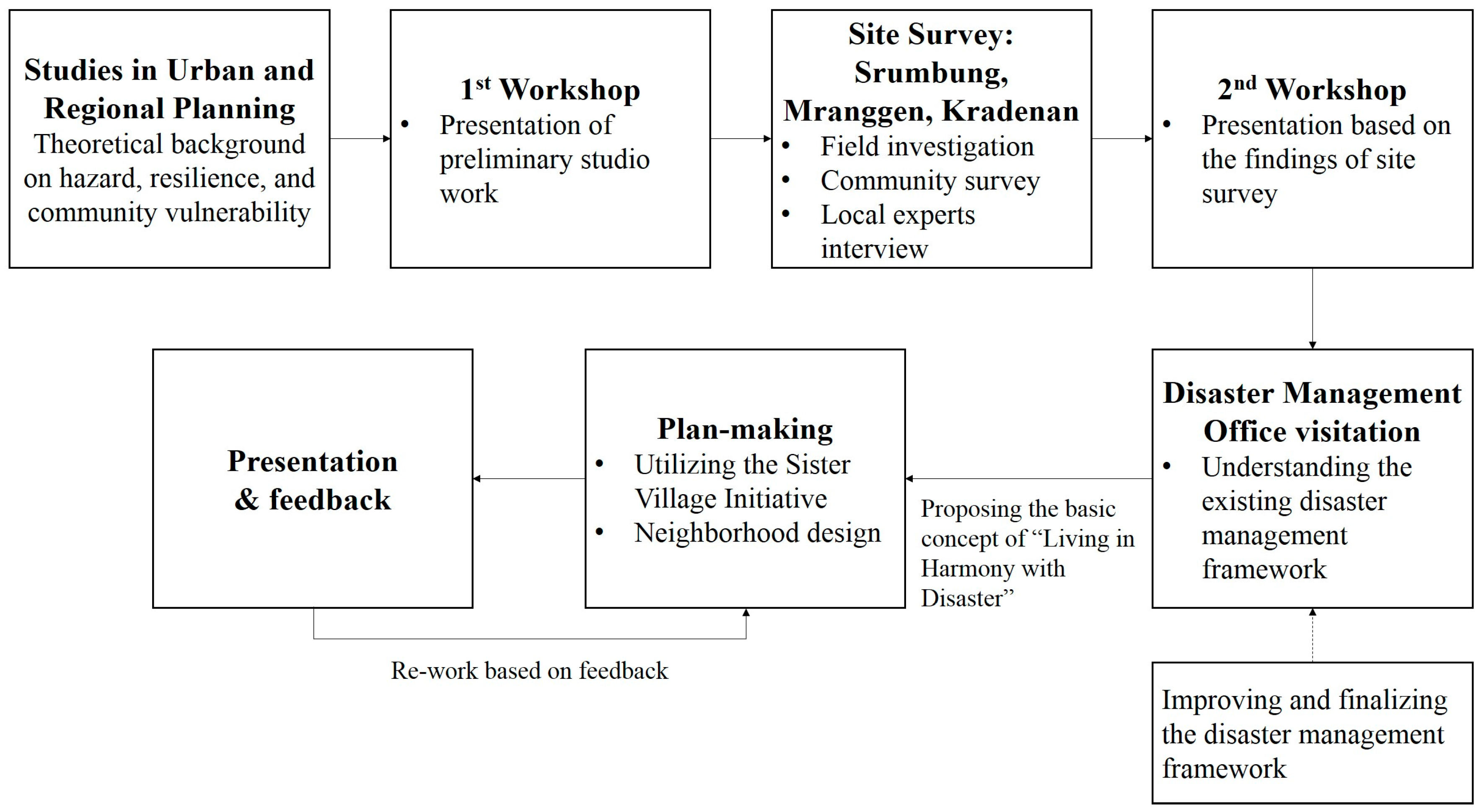
The joint planning studio was structured into two parts. First students were prepared through a seminar course titled Studies in Urban and Regional Planning which was then followed by field-based investigations. A joint field trip by Korean and Indonesian students was made to Magelang where they had observed the state of housing, public sanitary facilities, local economic activities such as stone-breaking and salak plantations, and the conditions of evacuation sites. Based on the field investigation, students refined issues of vulnerabilities which later developed into a planning concept and neighborhood level design proposals (
Figure 1).
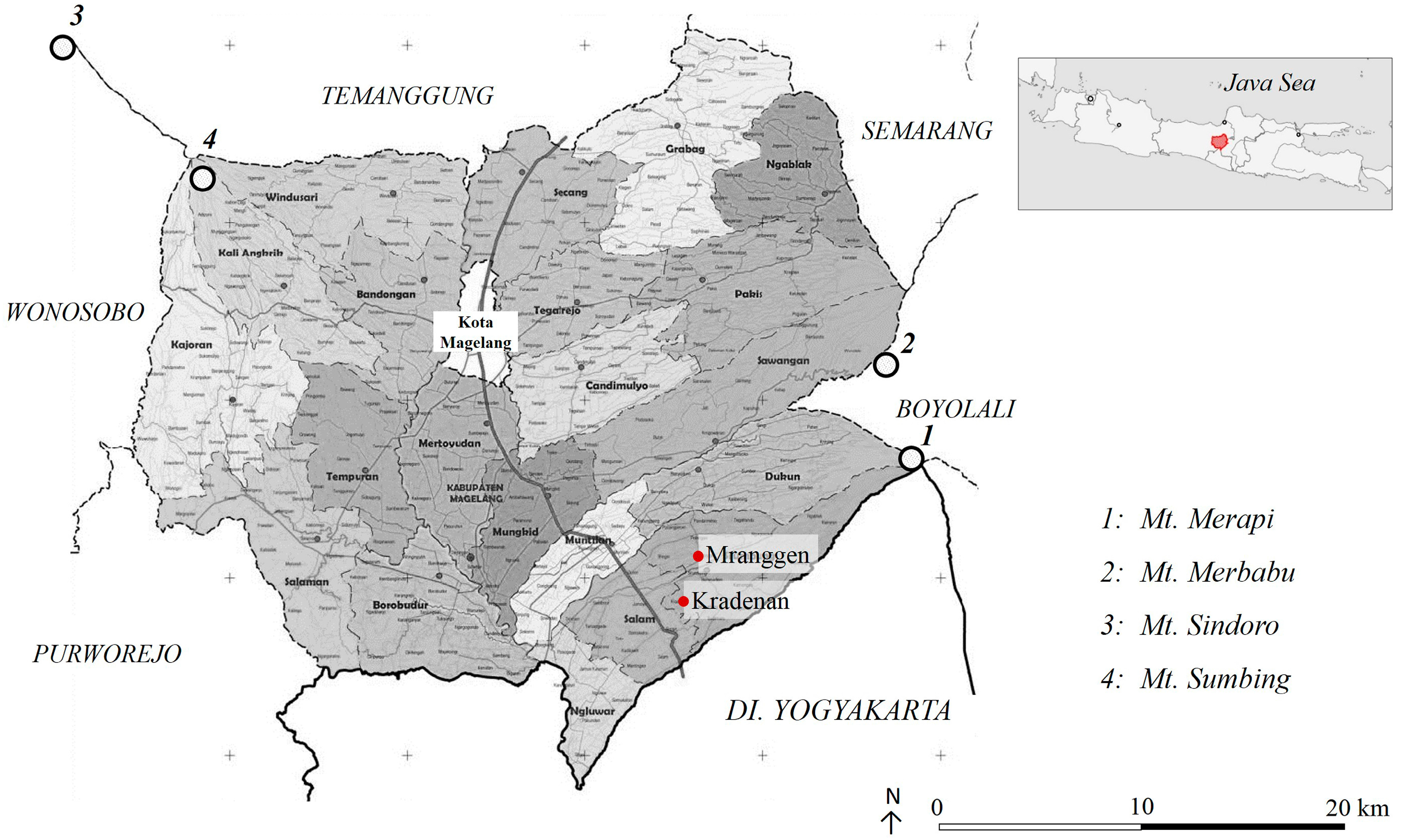
The site, Magelang Regency, is located in Central Java which consists of 24 sub-districts and covers an area of 110,385 ha (
Figure 2). Out of 129 active volcanoes in Indonesia, 43 are located in the Java islands which are also one of the most populous islands in Indonesia [
15]. Magelang is also situated in between Semarang, the capital of Central Java, and Yogyakarta. From a development perspective, this geographical position has been advantageous in the past and until now. Semarang, during the Dutch colonial period, had built its first railway in 1868 which spanned 405 km to Jakarta, and in 1903 this railroad connection was extended to Magelang. Today, various shopping and hotel complexes are being developed along the Magelang-Yogyakarta corridor acting as a major source of growth and urbanization in the area. However, considering the constant threat caused by natural hazards such rapid urbanization may pose added dangers, and based on interviews with the local authority, intensifying developments is not recommended in this area.
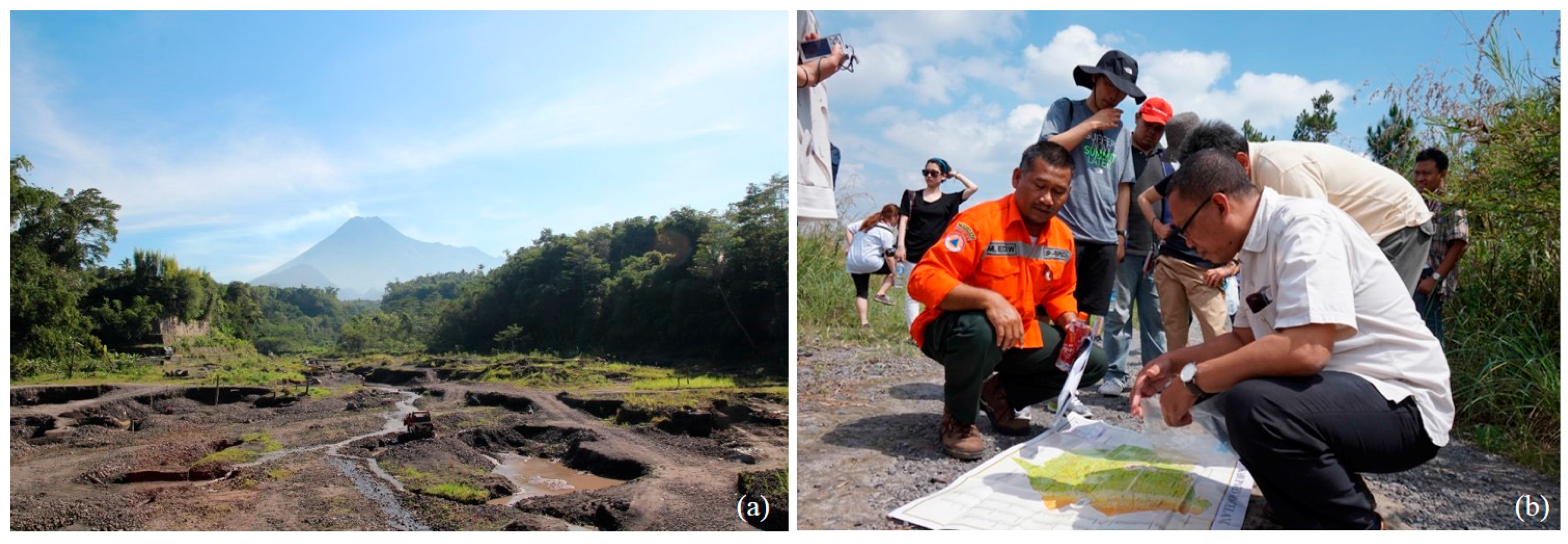
As of now, Magelang Regency is still largely an agriculture-based area where volcanic mountains—Mt. Merapi, Mt. Merbabu, Mt. Sindoro, and Mt. Sumbing—surround its administrative borders. The most recent eruption of Mt. Merapi in 2010 was a hundred-year event which does not compare in magnitude with previous eruptions, and had cost the lives of almost 400 people [
3,
16] (
Figure 3). According to various reports on the 2010 explosion the critical dates range between late October to early November [
16,
17], and on the days where series of intense explosions occurred, between 3–5 November, pyroclastic flows reached 12 km [
16]. Such pyroclastic flows were particularly detrimental to Dukun and Srumbung—both areas within a 15 km distance of the volcano—where 10.13 km
2 of the floriculture site in Dukun, and 14.20 km
2 of salak plantation in Srumbung were destroyed [
15].
3.2. Identifying Issues of Vulnerability
Based on various records, the issues of vulnerability in Magelang were identified to be both natural and human-induced which could be categorized into three different aspects: the economic; the environmental; and the infrastructural. The economic vulnerability rose from the fact that the majority of households were reliant on subsistence agriculture [
15]. Considering that the agricultural sector is affected most in the event of a volcanic eruption and that the service sector is only concentrated along major transport routes, the residents of Magelang are thought to be economically marginalized. In terms of environmental vulnerability, the close proximity to the volcano, the subsequent flooding of rivers and other forms of natural disasters are critical. Furthermore, Magelang also suffers from poor infrastructure and public services which indirectly exacerbates the already vulnerable conditions of the site. There are currently no proper wastewater treatment facilities installed in Magelang, and hence serious problems of water pollution and odor are left untreated. Villagers rely on local springs or village wells for drinking water which have a high possibility of contamination, and although there are local water supply companies, these only cover 3.5% of the total demand. Road conditions are poor and there are no proper mechanisms for treating urban waste, which adversely affects reconstruction efforts in the aftermath of a disaster [
15].
Furthermore, through student-led surveys, a closer understanding of what the volcanic eruptions really implied in the community shed light on locally-specific vulnerability issues (
Appendix A). A total of 49 villagers were surveyed: 15 from Srumbung; 15 from Mranggen; 10 from Kradenan and nine village officers. The survey was conducted flexibly incorporating interview questions to encourage as much conversation with the villagers. Village officers were also interviewed to better understand the difficulties behind implementing relocation plans and the desires of the communities. Students had discovered through site investigations that despite the dangerous conditions posed by Mt. Merapi, villagers were highly resistant towards relocation. Survey results showed that 82% of the local community disagreed to relocation for livelihood reasons (33%), and attachment to community environment (25%) (
Figure 4). The majority of the local community (78%) were involved in salak plantation, by which Mt. Merapi provided good soil conditions for agricultural businesses. Additionally, there were post-disaster economic gains made through selling volcanic eruption materials, and so even after the 2010 eruption, most local villagers did not change or consider changing their source of income (91%). In fact, farmers waited until re-cultivation of salak was possible, whilst working in temporary job conditions and receiving government aid.
The survey also revealed the community’s strong cultural attachment to the environment. Local villagers displayed strong connections to the land that had been inherited for generations and also shared a common cultural view that Mt. Merapi was genuinely harmless. In fact, people perceived Mt. Merapi not as a threat but a positive element which allowed the blessings of fertility, providing a good source of water and other comforts. Inhabitants often said that the mountain had the right to “cough” once in a while and although hardships were caused by this, there was a sense of humble satisfaction that the mountain gifted the area with fertilized soil. Ironically, the community considered Mt. Merapi to be the source of sustainable living, which also influenced their perceptions of risk whereby fatalities were caused due to the refusal of evacuation.
To summarize, the volcano which posed substantial hazard risks to the community also served as a source of economic resource and a place of communal belonging, complicating the understanding of vulnerability. The villagers chose to remain in an environmentally vulnerable site rather than expose themselves to further economic vulnerability due to the lack of alternative employment skills, and also refused to be detached from their social ties and traditional values. Such complicated notions of vulnerability significantly informed the general planning and design directions in the later stages.
4. Design Proposals
Taking into account the complex understanding of vulnerability, the study put forth the concept of “living in harmony with disaster”. This was to respect the local community’s desires and recognize that a permanent relocation plan would not be successful. The overall concept of embracing disaster was divided into four principles: community resilience, economic sustainability, shared responsibility, and design for all.
Based on this planning concept new ideas were introduced into the existing disaster management framework which mainly focused on reducing the environmental and infrastructural vulnerabilities of the area. For each stage of disaster—pre-disaster, during-disaster emergency response and post-disaster—response measures were proposed by physical, socioeconomic and institutional aspects (
Table 1). The pre-disaster stage is primarily concerned with preventative measures such as introducing zoning control along the Kali Putih River, designating clear evacuation zones to minimize confusion, regulating sand mining and allowing for sustainable development in the area. The underlying thought is that development should not be undermined because of a natural hazard, and areas of strict regulation should be clearly defined. On an institutional level, an integrated forum between communities is suggested so that community relations can be strengthened prior to a disastrous event. During the impact stage of the volcanic hazard, efforts are concentrated on mobilizing various local and community-based funds to cope with the disaster and any immediate rehabilitation efforts. In the post-disaster stage, again zoning is a key component since fixed and temporary settlements need to be clearly designated so as to reduce conflict and provide stable living conditions for those displaced. Another crucial aspect is legally resolving land-use and improving infrastructure systems.
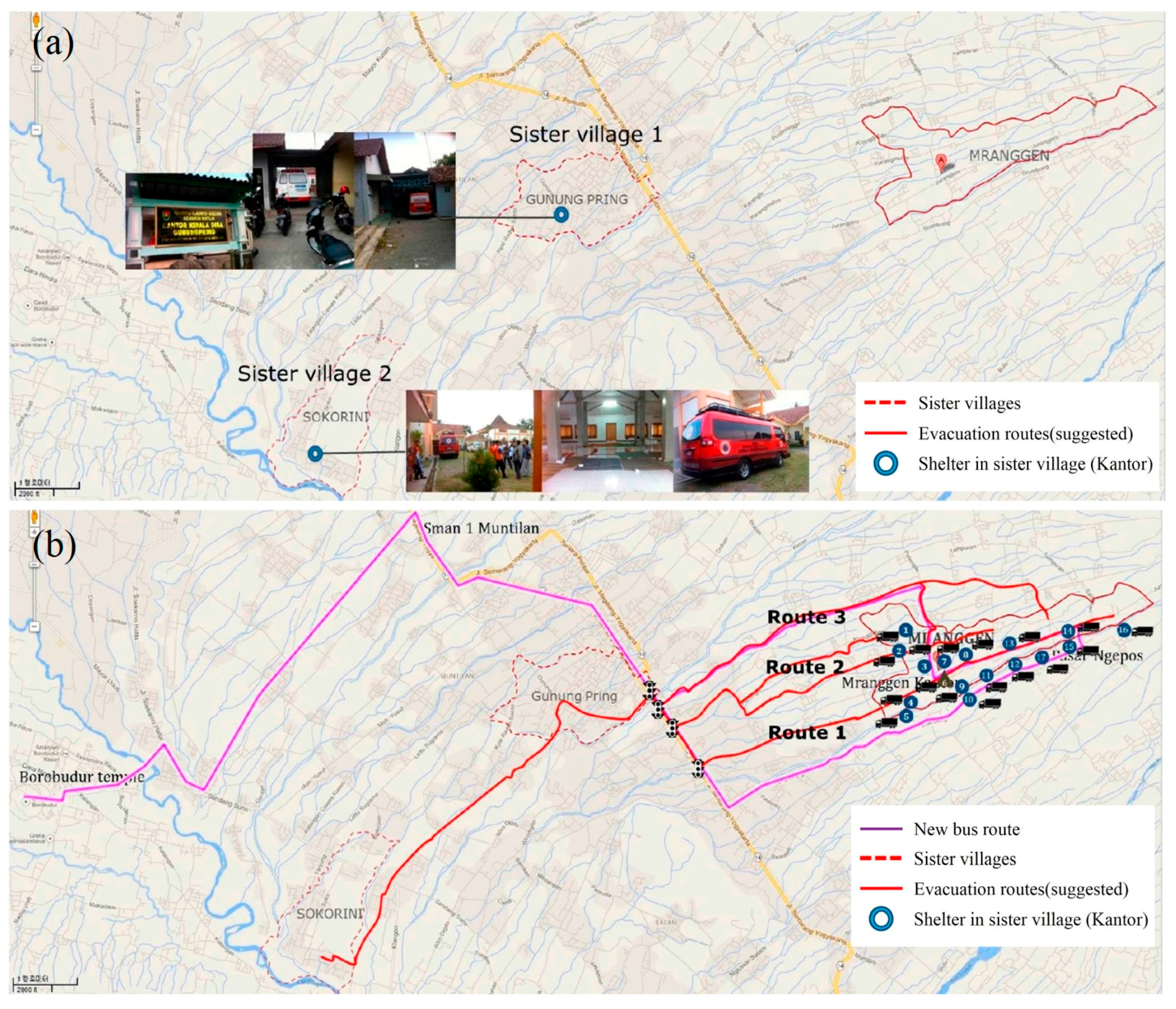
Incorporated into the disaster management framework is another key local concept known as the Sister Village Initiative. This already existing concept of linking vulnerable villages with neighboring villages had been strengthened through the support of a United Nations Development Programme project. By the end of 2014, 21 villages were linked with neighboring villages [
18]. The Sister Village Initiative was further developed in this study by clearly designating evacuation routes and encouraging community bonds on a regular basis. In the event of a disaster, individual households could escape to the community shelter, then temporarily migrate to a neighbor’s home—or a paired sister’s place—located in a safer community along a designated route with a reliable mode of transportation. Accordingly, urban design and transportation plans that facilitate the notion of the Sister Village Initiative were put forth by building a post-disaster refugee camp that also functions as a pre-disaster meeting point (
Figure 5). Also, it was evident from the Sister Village Initiative that the communities were determined to overcome disaster rather than take advantage of an unsettling situation where looting or illegal settling may occur.
Furthermore, the general idea of the planning concept and disaster management framework was materialized in the neighborhood design proposals which suggested ways of mitigating for economic vulnerabilities. Two areas, namely Mranggen and Kradenan, were selected as these exemplified the Sister Village Initiative concept. Mranggen, situated directly beneath Mt. Merapi stretching along the Kali Putih River, is the more vulnerable site of the two areas and severely lacks social and economic foundations. Most inhabitants cultivate salak individually in their home gardens. In the aftermath of the 2010 eruption, the fields and plantations in Mranggen took almost three years to recover. Therefore, improving income levels and livelihood conditions is of paramount importance in Mranggen. On the other hand, Kradenan is an area famous for the production of high-quality salak and is also the only area where a Farmers’ Association overlooks the salak production process. Kradenan also enjoys good transportation links and is en route to a UNESCO World Heritage Site, the Borobudur temple, where over a million foreign tourists visit annually. Hence, it was suggested that these two areas develop a cooperative business model which involves a salak farm tour at Kradenan and the production of salak-processed crafts at Mranggen. Against this background, the following design proposals were made.
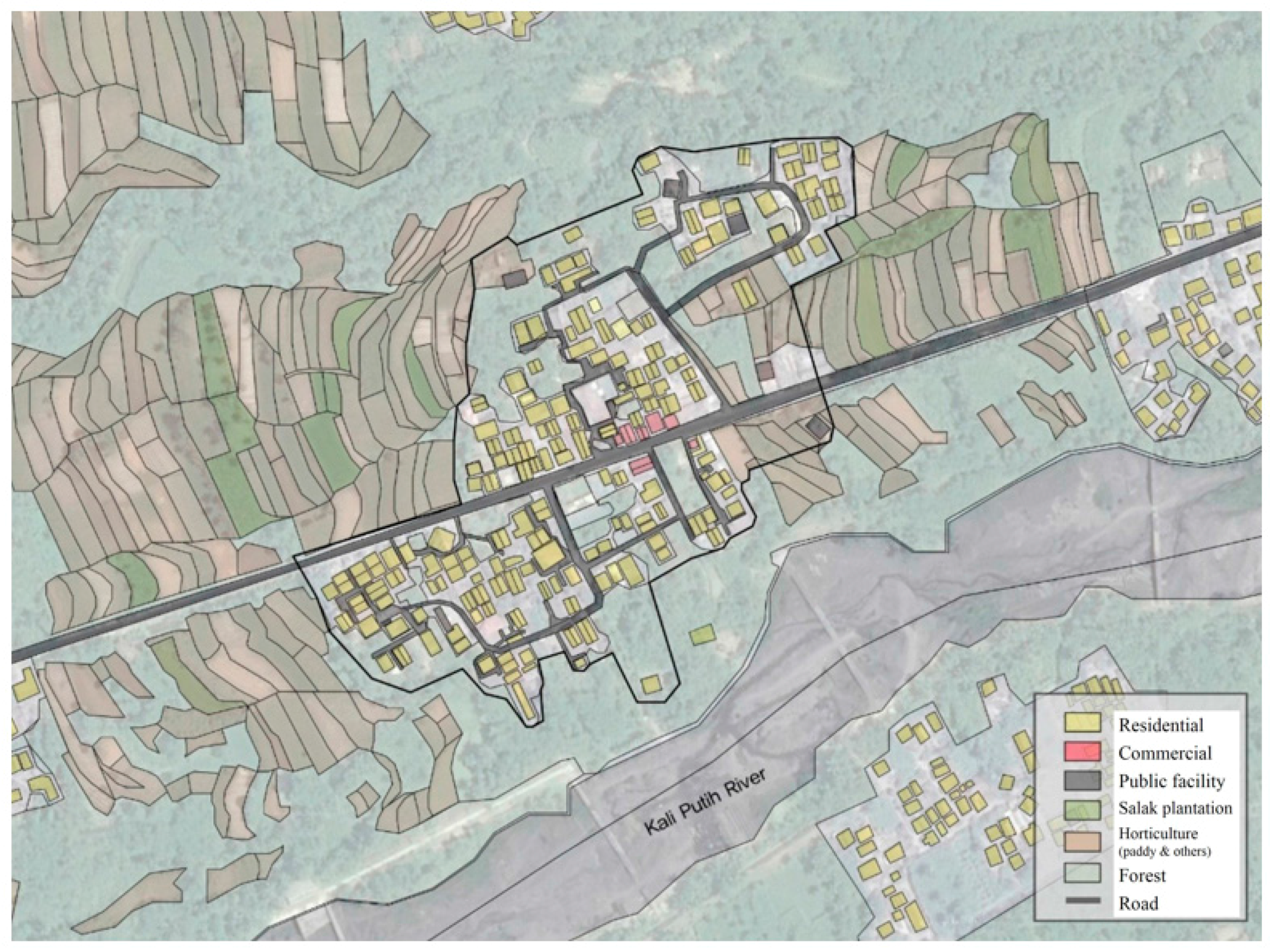
The area in close proximity to the Kali Putih River in Mranggen was designated as a flexible disaster mitigation zone. This involved the removal of existing residential units and the community school near the Kali Putih River and utilizing this buffer area flexibly in pre-disaster, disaster, and post-disaster stages. The newly moved community school could also serve as the education center where inhabitants can train in making salak crafts and diversifying income sources. Under normal conditions, this flexible zone could be used to accommodate for sand-mining work where offices, a delivery center, storage facilities and a parking area can be located. However, in the event of a disaster the same area could be used as a parking lot where aid materials can be effectively transported to the site. In the post-impact stage, the same area could be used as the base camp for reconstruction efforts (
Figure 6).
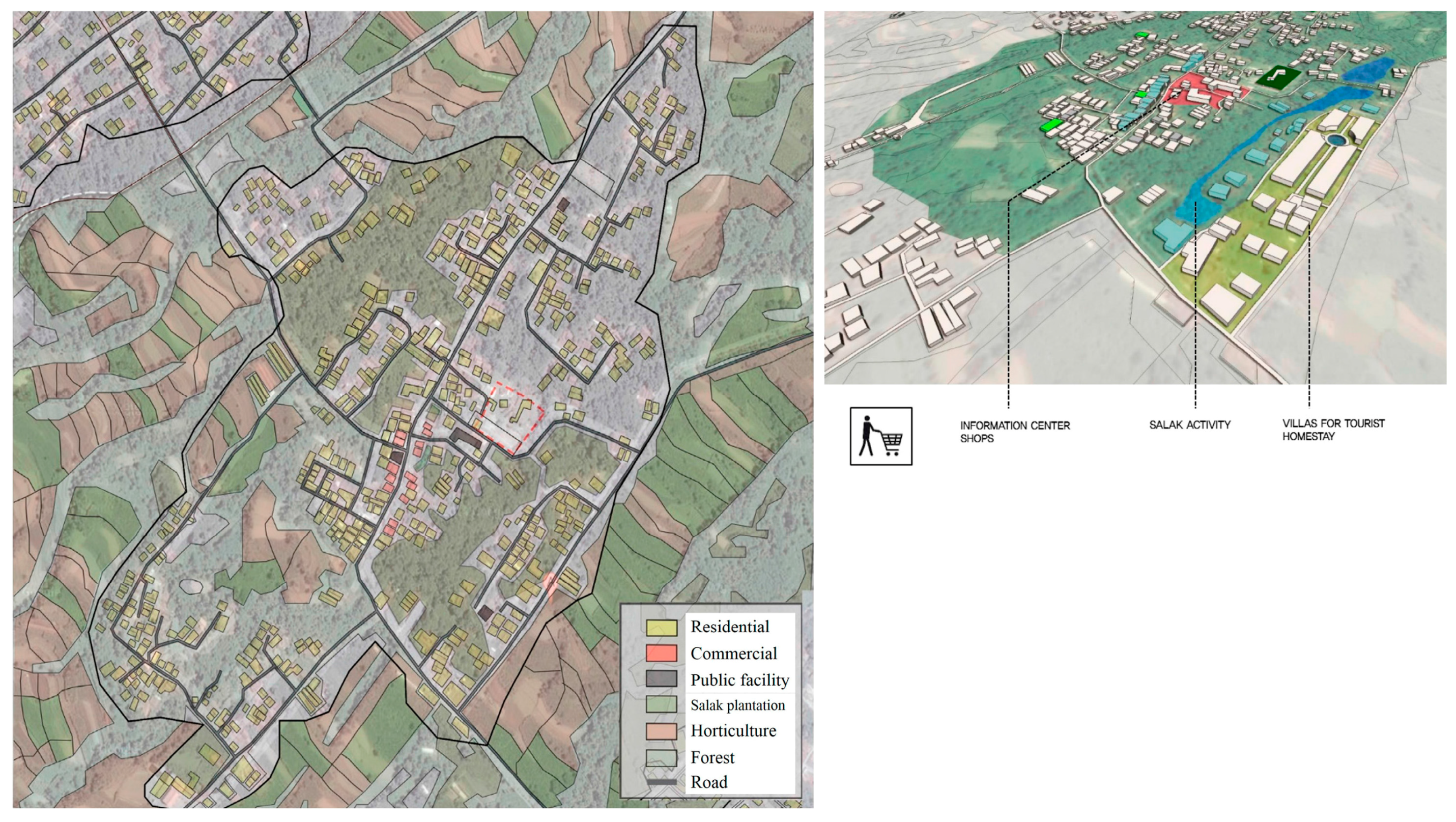
Kradenan served as a model for countering economic vulnerability through salak plantation agro-tourism. The area is already well known for its sweet salaks which could potentially generate further income by introducing salak farm tours. Hence, the design strategy focused on planning a successful tourist site by incorporating the existing cultural and natural resources. Spatially, a better connection between the neighborhood’s mosque and plantation site was proposed. This was to reinforce a strong axis between these two sites and allow for improved navigation for potential tourists. The main tourist area was designated in the southern part close to the salak plantation area and the newly proposed central information center and shops. The proposed villas for tourists were located along a natural stream, which could also serve as an education center so that the activities of the Farmers’ Association and the general economic capabilities of the villagers could be further supported (
Figure 7).
5. Conclusions and Discussion
5.1. Environmental Hazard as a Vehicle for Understanding Local Wisdom
Interactive talks among participants and locals through intensive field studies on localized lifestyles enabled novel findings of the issues of vulnerabilities which cannot be reproduced prior to such an engagement. From the outset, the study focused on defining the various aspects of vulnerability, and expected the environmental hazard to be the most detrimental aspect of them all. Therefore, resolving the problems of environmental hazards was directly linked to drawing up relocation plans. However, after understanding the complicated relation the community formed with the hazardous site, the studio recognized that an effective strategy for eliminating environmental vulnerability may in fact increase economic vulnerability. In this respect, a natural hazard acts as a catalyst where the intricately linked issues of vulnerabilities are brought to the surface. In other words, the process of learning locally specific problems served as a vehicle in abolishing preconceptions and helped to reframe the planning approach. Without such involvement, it is difficult to expect practical mitigation strategies that avoid making the mistake of prescribing oversimplified measures.
5.2. Designing with Local Knowledge
By effectively using local wisdom, the study was able to put forth pragmatic planning approaches which were demonstrated through the strengthening of the disaster management framework and the use of the Sister Village Initiative. In its original form the sister village concept was a simple mechanism of allowing immediate shelter and external assistance to the affected communities. However, under normal circumstances communities showed very limited exchange. In recognizing the potential of this concept, the study suggested that the evacuation center prior to any hazard threats could be used as a community center where different communities can interact and form bonds on a regular basis. In the event of a disaster, households could be partnered so that evacuation and temporary settlement processes can be streamlined with improved transportation routes. Neighborhood design approaches were also sensitive towards the existing local activities and sought to better integrate economic means with spatial planning. As demonstrated above, key strategies discovered from the field investigation were further advanced when drawing up mitigation strategies that are appropriate and unique to the site.
However, there were also challenges in incorporating local knowledge into the overall planning and design approaches. Clearly local knowledge formed an invaluable part in prescribing mitigation measures and was considered one of the most successful aspects of the study. However, at the same time, local perspective and cultural knowledge can have an overwhelming influence on the progression and outcome of the mitigation plan and therefore it is important for participants to retain a critical standpoint. Deciding to what extent the complicated relations between people and the volcanic mountain need to be embraced was an issue that was continuously debated among participants.
As a conclusive statement, although many useful planning and mitigation strategies were presented, the research is limited in that the effectiveness of these ideas could not be directly tested. Despite such limitations, this study provided an opportunity for both Korean and Indonesian participants to re-think the notion of community resilience which had evidently generated further discussions on site-specific hazard mitigation planning.
Acknowledgments
We would like to thank the Diponegoro faculty and studio participants for their invaluable input and knowledge. This work was supported by the BK21 Plus Project in 2016 (Seoul National University Interdisciplinary Program in Landscape Architecture, Global leadership program towards innovative green infrastructure). This work was also supported by the Korea Ministry of Environment (MOE) as “Climate Change Correspondence Program (Project number: 2014001310007)”. Discussion about future international collaboration was supported under the framework of the international cooperation program managed by the National Research Foundation of Korea (NRF-2013K2A1A2055287).
Author Contributions
Sea Eun Cho and Sehyung Won designed and structured the article. Saehoon Kim provided expertise in discussing the design proposals and conclusions. The article was improved by co-authors at various stages of the writing process.
Conflicts of Interest
The authors declare no conflict of interest.
Appendix A. Survey Questionnaire
| Disaster and relocation |
| 1. | Are you willing to relocate to a safer area as recommended by the government? |
| □ Yes | □ No | |
| If no, why are you unwilling to relocate to a safer area? |
| □ Livelihood reasons |
| □ Attachment to community environment |
| □ Livelihood reasons and attachment to community |
| □ Others (please specify) |
| Disaster and livelihood |
| 2. | What is your current employment? |
| □ Agriculture/farming | □ Public office | |
| □ Private business | □ Others | |
| 3. | Have you ever experienced discontinuity of employment due to a volcanic eruption? |
| □ Yes | □ No | |
| If yes, how many months were you unemployed for? |
| months |
| 4. | Have you ever changed jobs after experiencing employment discontinuity due to a volcanic eruption? |
| □ Yes | □ No | |
| If no, please explain why (e.g., job carried on through generations, lack of alternate skills, lack of job information etc.). |
| |
| Disaster and community |
| 5. | What types of community groups are you involved with? |
| □ None | | □ Pramuka | □ Others | |
| □ PKK | | □ Farmers’ Association | |
| 6. | How often do you get involved in the community group’s activities? |
| times per month |
| 7. | Where are the main gathering places for these groups? |
| |
| |
| 8. | Please describe disaster support activities carried out by the community groups you are involved with, if any. |
| |
| |
References
- Kim, S.; Rowe, P.G. Are master plans effective in limiting development in China’s disaster-prone areas? Landsc. Urban Plan. 2013, 111, 79–90. [Google Scholar] [CrossRef]
- Smith, K. Environmental Hazards: Assessing Risk and Reducing Disaster; Routledge: New York, NY, USA, 2013. [Google Scholar]
- Mei, E.T.W.; Lavigne, F.; Picquout, A.; de Belizal, E.; Brunstein, D.; Grancher, D.; Sartohadi, J.; Cholik, N.; Vidal, C. Lessons learned from the 2010 evacuations at Merapi volcano. J. Volcanol. Geotherm. Res. 2013, 261, 348–365. [Google Scholar] [CrossRef]
- World Health Organization. Mt. Merapi Volcano Eruption, Central Java Province, Republic of Indonesia: Emergency Situation Report; World Health Organization: Jakarta, Indonesia, 2010. [Google Scholar]
- Kuncoro, D.; Nugroho, K.; Sarwani, M. Agricultural recovery action for area affected by 2010 Merapi volcano eruption, Indonesia. Int. J. Geoinform. 2012, 8, 41–48. [Google Scholar]
- Wilson, T.; Kaye, G.; Stewart, C.; Cole, J. Impacts of the 2006 Eruption of Merapi Volcano, Indonesia, on Agriculture and Infrastructure, GNS Science Report; Institute of Geological and Nuclear Sciences: Lower Hutt, New Zealand, 2007. [Google Scholar]
- Adger, W. Social and ecological resilience: Are they related? Prog. Hum. Geogr. 2000, 24, 347–364. [Google Scholar] [CrossRef]
- Norris, F.H.; Stevens, S.P.; Pfefferbaum, B.; Wyche, K.F.; Pfefferbaum, R.L. Community resilience as a metaphor, theory, set of capacities, and strategy for disaster readiness. Am. J. Community Psychol. 2008, 41, 127–150. [Google Scholar] [CrossRef] [PubMed]
- Cutter, S.L.; Boruff, B.J.; Shirley, W.L. Social vulnerability to environmental hazards. Soc. Sci. Q. 2003, 84, 242–261. [Google Scholar] [CrossRef]
- Pais, J.F.; Elliott, J.R. Places as recovery machines: Vulnerability and neighborhood change after major hurricanes. Soc. Forces 2008, 86, 1415–1453. [Google Scholar] [CrossRef]
- Tobin, G.A.; Whiteford, L.M. Community resilience and volcano hazard: The eruption of Tungurahua and evacuation of the faldas in Ecuador. Disasters 2002, 26, 28–48. [Google Scholar] [CrossRef] [PubMed]
- Boyce, J.K. Let them eat risk? Wealth, rights and disaster vulnerability. Disasters 2000, 24, 254–261. [Google Scholar] [CrossRef] [PubMed]
- Burby, R.J.; Deyle, R.E.; Godschalk, D.R.; Olshansky, R.B. Creating hazard resilient communities through land-use planning. Nat. Hazards Rev. 2000, 1, 99–106. [Google Scholar] [CrossRef]
- Nelson, A.C.; French, S.P. Plan quality and mitigating damage from natural disasters: A case study of the Northridge earthquake with planning policy considerations. J. Am. Plan. Assoc. 2002, 68, 194–207. [Google Scholar] [CrossRef]
- Seoul National University. Vulnerability, Resilience, and Planning Intervention. A Semester of International Joint Workshop through Field Trips, Research, Lecture, and Planning Studios; Seoul National University: Seoul, Korea, 2014. [Google Scholar]
- Jousset, P.; Pallister, J.; Boichu, M.; Buongiorno, M.F.; Budisantoso, A.; Costa, F.; Andreastuti, S.; Prata, F.; Schneider, D.; Clarisse, L.; et al. The 2010 explosive eruption of Java’s Merapi volcano—A ‘100-year’ event. J. Volcanol. Geotherm. Res. 2012, 241, 121–135. [Google Scholar]
- Cronin, S.J.; Lube, G.; Dayudi, D.S.; Sumarti, S.; Subrandiyo, S. Insights into the October–November 2010 Gunung Merapi eruption (Central Java, Indonesia) from the stratigraphy, volume and characteristics of its pyroclastic deposits. J. Volcanol. Geotherm. Res. 2013, 261, 244–259. [Google Scholar] [CrossRef]
- Sister Villages: Linking Communities for Disaster Preparedness. Available online: https://undpid.exposure.co/sister-villages (accessed on 21 August 2016).
© 2016 by the authors; licensee MDPI, Basel, Switzerland. This article is an open access article distributed under the terms and conditions of the Creative Commons Attribution (CC-BY) license (http://creativecommons.org/licenses/by/4.0/).


