Review

A Review of the Application of Remote Sensing Data for Abandoned Agricultural Land Identification with Focus on Central and Eastern Europe

1
Institute of Geography, Slovak Academy of Sciences, Štefániková 49, 814 73 Bratislava, Slovakia
2
National Forest Centre—Forest Research Institute Zvolen, T. G. Masaryka 22, 960 01 Zvolen, Slovakia
3
Swiss Federal Institute for Forest, Snow and Landscape Research WSL, Zürcherstrasse 111, CH-8903 Birmensdorf, Switzerland
*
Author to whom correspondence should be addressed.
Remote Sens. 2019, 11(23), 2759; https://doi.org/10.3390/rs11232759
Submission received: 15 October 2019 / Revised: 21 November 2019 / Accepted: 21 November 2019 / Published: 23 November 2019

Abstract

:
This study aims to analyze and assess studies published from 1992 to 2019 and listed in the Web of Science (WOS) and Current Contents (CC) databases, and to identify agricultural abandonment by application of remote sensing (RS) optical and microwave data. We selected 73 studies by applying structured queries in a field tag form and Boolean operators in the WOS portal and by expert analysis. An expert assessment yielded the topical picture concerning the definitions and criteria for the identification of abandoned agricultural land (AAL). The analysis also showed the absence of similar field research, which serves not only for validation, but also for understanding the process of agricultural abandonment. The benefit of the fusion of optical and radar data, which supports the application of Sentinel-1 and Sentinel-2 data, is also evident. Knowledge attained from the literary sources indicated that there exists, in the world literature, a well-covered problem of abandonment identification or biomass estimation, as well as missing works dealing with the assessment of the natural accretion of biomass in AAL.

Graphical Abstract

1. Introduction

Agricultural land abandonment is a widespread land use (LU) change in different parts of the Earth’s land surface. Cessation of agricultural activities has significant environmental consequences, such as loss of biodiversity in former grasslands or changes in the character of important bird nesting areas. Abandonment is a dynamic process affected by a complex range of drivers that vary over time and space [1]. Generally, it occurs in areas where farming is not viable due to geographic position, demographic and socio-economic factors, unadapted agricultural systems, mismanagement (resulting in soil degradation, frequent flooding, overexploitation, and productivity loss), historical factors (e.g., the restitution process), and agro-ecological factors (e.g., low quality infertile lands) [2,3].
Environmental drivers of agricultural abandonment process could be, for example, elevation, slope, erosion, clime, and fertility [2]. Several hypotheses linked with these drivers were analyzed—soil type, elevation, slope, and agricultural suitability as powerful predictors and topographical marginality as not a major determinant of abandonment [4].
Socio-economic factors could be represented as migration and rural depopulation, new economic opportunities (tourism, industrialization, housing, etc.), land-tenure system, accessibility by road (directly linked together with proximity to town), market incentives, agrarian policy, farmer’s age, or input and output prices [2]. Accessibility variables are important predictors of agricultural abandonment in Romania [5], but the statistical importance of this factor is low [4]. Transnational or national policies are also important driving factors in agricultural land management [6]. Meyfroidt et al. [7] analyzed crude birth rate, rural life expectancy, population density, ethnic population, and yields of grains as determinants of abandoned agricultural land. This assessment of the socio-economic factors confirmed that the process of agricultural land abandonment is widespread and persistent in socially marginal areas with declining yields and a diminishing and less demographically active population [7,8].
The Common Agricultural Policy (CAP), in European countries, aims not only to support food safety and farmers’ incomes, but also to sustain typical features of rural landscape to avoid the risk of agricultural abandonment. Special measures are important, especially in less-favored areas with low soil productivity or poor climate conditions, where farming activity is crucial for land management. According to a model-based assessment of the potential impact of agricultural and trade policy reform on LU, it is estimated that around eight percent less land will be farmed under the most recent CAP reform. However, in some regions, policies from other sectors (such as nature conservation or environmental restrictions) may influence the profitability of continuing agricultural practices [9].
In Eastern Europe, the transition from a command to free-market-oriented economies, after the fall of the Iron Curtain in 1989, has drastically changed the region’s political, socio-economic and demographic structures [10]. Widespread LU changes, including the process of agricultural land abandonment in Eastern Europe, was triggered by the collapse of socialism and the resultant radical institutional reforms and economic shocks [4]. State-support and markets for agriculture disappeared, new land management policies were issued, and land reforms resulted in massive land ownership transfers. Land abandonment may be a consequence of low crop yields, market protection policies, and increased imports of farm crops from other parts of the world, but can also be a result of abrupt or progressive LU change caused by environmental or socio-economic factors mentioned before [11,12].
Different definitions of agriculture abandonment depend on the nature of their approach—administrative, economic, social, landscape-ecological, or agronomic—and are adaptable to the context of different countries. For example, some countries use the qualitative definition of abandoned land (such as a description of the land condition), whereas others have a quantitative definition (e.g., number of years without cultivation or grazing) [13]. In all cases, agricultural land is considered to be abandoned when it has no farming functions anymore.
Landscape analysis and assessment, mainly in terms of farming activities, require the definition of agricultural land, which is, and always has been, highly dynamic due to its recreation by humans over centuries. For this study, we adopted the definition of the Food and Agriculture Organization [14], according to which, agricultural land is represented by arable land, permanent crops, permanent meadows, and permanent pastures. Arable land is associated with the cultivation of occasional crops and occasional meadows for mowing and grazing. Vineyards and orchards, or plantations of fruit shrubs belong to permanent cultures. Permanent meadows and pastures are represented by grass areas used for mowing and grazing that do not belong to the crop rotation system.
Table 1 contains the generalized abandonment classes of agricultural land in Central Europe. The area is susceptive to a gradual process, which manifests by physiognomic changes (such as a heterogeneous arrangement, i.e., clustering of vegetation and variability of its tallness) and by the accretion of new vegetation species, herbs, wind-borne weeds, and trees (which diversify or replace monocultures of annual and perennial farm crops, vineyards, and orchards). Coppin et al. [15] refer to such land cover (LC) changes as ‘modification’, that is, the progressive disappearance of the content of the original LC/LU class. The opposite to this type of LC/LU change is ‘conversion’, which is a radical change from one type of LC/LU class to another type of LC/LU class (for example, the transformation of a meadow into arable land [16]).
Agricultural changes that took place in the countries of Central and Eastern Europe after 1989 should also be taken into account since they led to the transformation of the structure of agriculture in these countries [18]. The abandonment of agricultural land and the subsequent overgrowth by trees as documented by Taff et al. [19] in Latvia, Angelstam et al. [20] and Kozak et al. [21] in Poland, Bičík et al. [22] in Czechia, and Gabrovec and Kladnik [23] in Slovenia prove this. In Slovakia, Pazúr et al. [24] identified a more intensive abandonment of agricultural land with lower soil quality located in less accessible places and neighborhood areas not used for farming; they also found that the abandonment of agricultural land was affected by changes in the population structure in rural areas and by migration. Levers et al. [25] studied abandonment in 1 km grid cells and an aggregation of values in these cells using MODIS-based maps from Estel et al. [11] indicated 3–5 years of management followed by at least five fallow years.
Because of the enormous scope of the present processes of land abandonment in Central and Eastern Europe, which creates canopied forests and shrub stands outside the actively managed forests, it is necessary to include these changes into the global carbon storage and cycle. First of all, conventional approaches to the identification of abandoned agricultural land (AAL) apply data obtained in field surveys [26]. The operative and efficient acquisition of information, for instance, concerning the occurrence and dynamics of AAL, especially in larger areas, is often problematic. Satellite remote sensing (RS) data help to eliminate these problems as such data are acquired at regular time intervals, which makes it possible to track the development of AAL in different land sizes from tens to thousands of hectares at the same time and by means of one physical quantity, that is, electromagnetic radiation.
In this context, this study aimed to summarize and assess all studies (published between 1992 and 2019 and recorded in the Web of Science (WOS) and Current Contents (CC) databases) focusing on the identification and development of AAL via the application of satellite data obtained in the optical and microwave spectra of electromagnetic radiation. Cognition of occurrence and size of the changing agricultural land in favor of AAL is important, for instance, in association with the EU Regulation No. 2018/841 of the European Parliament and of the Council of 30 May 2018 [27] on the inclusion of greenhouse gas emissions and removals from LU, LC change, and forestry in the 2030 climate and energy framework. One such change is abandonment. It is the reason why this study documents how this issue is treated in studies published from 1992 to 2019. This study does not aim at a comprehensive evaluation of abandonment drivers. The wide range of causes of AAL requires further selection of literature through new keywords to identify relevant contributions to this problem.

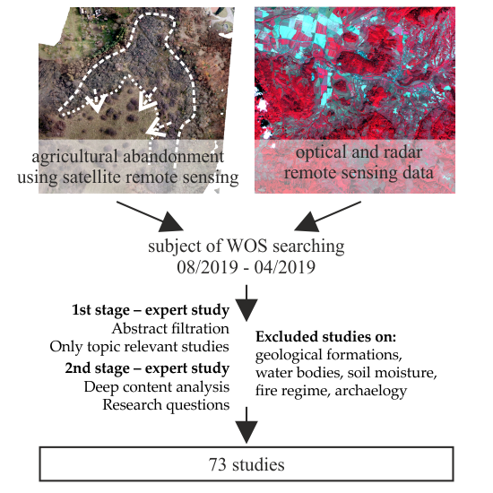
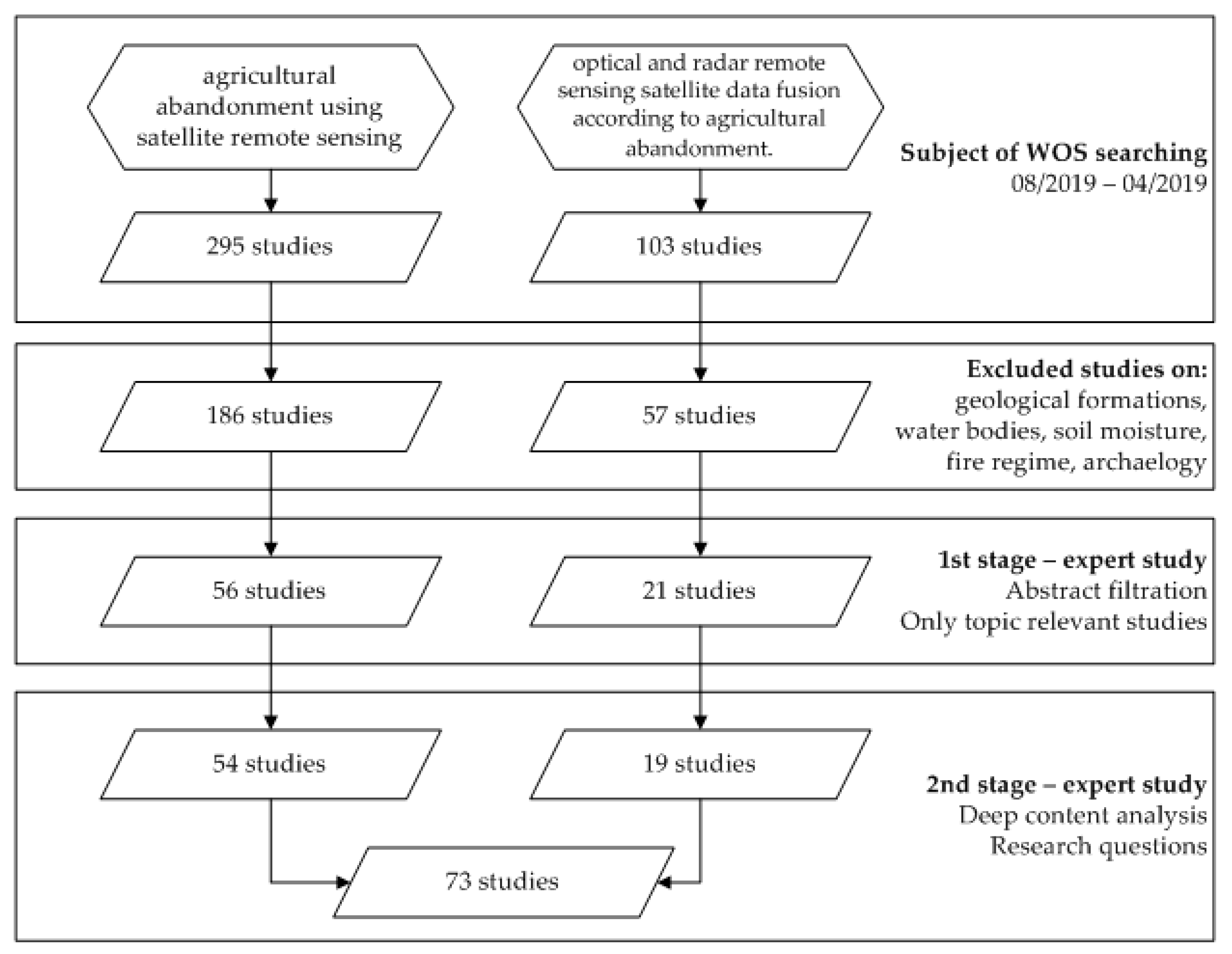
2. Background of Literature Database Processing

This search was carried out by making use of structured queries in the form of field tags and Boolean operators through the WOS (http://apps.webofknowledge.com) portal. Combinations of keywords and their synonyms interlinked by the operators to create the searching query were used. The search was conducted from August 2018 to April 2019 (Figure 1). Two different search queries were performed, focusing on agricultural abandonment using satellite RS and optical/radar RS satellite data fusion according to agricultural abandonment (Table 2).
The resulting set of relevant studies after iterative optimization contained 398 papers. Based on the abstracts of these papers and according to the search terms, studies that did not address any form of study intent were excluded. In general, studies investigating geological formations, water bodies, maritime, soil moisture, fire regime, or archaeology were rejected because the search algorithm also normally generates items that do not always correspond to the search parameters. Consequently, 243 studies were used in further processing.
The first stage of the expert study consisted of a thorough analysis of 243 abstracts and a more consistent filtration. After removing duplicity, 77 papers dealing directly with the relevant analyzed expert terms were considered in the following stage of the expert study.
In the second stage, these 77 papers were subjected to a deep content analysis, keeping in mind the a priori specified research questions (Table 3). Several other papers were further removed, so the final number of analyzed papers was 73 (Table 2). An additional 25 studies, which were relevant for acquisition of knowledge about the AAL issue, were added to the original 73 papers analyzed according to the criteria mentioned in Table 3. These 25 studies are cited in the introduction and discussion sections of this review. These studies were not subjected to an expert assessment of the literature.
During the expert analysis, the specification and definition of AAL and criteria were emphasized. In general, the process of identification of the LC/LU classes or of agricultural classes which might directly or indirectly impact AAL was also closely related. The identification of the applied data of optical and microwave parts of the spectra and their qualitative support by field surveys represented an important part of the analysis. The classification algorithms or other approaches applied in the AAL identifying process were also considered. The search also resulted in the identification of agriculturally oriented papers devoted to the fusion of optical and radar data (without special stress on AAL).

3. Results

The analyzed set consisted of 73 studies (Table 2); each was given a unique ID number listed in the references section. The papers were published in the years 1992–2018 (Figure 2) by 60 first authors.

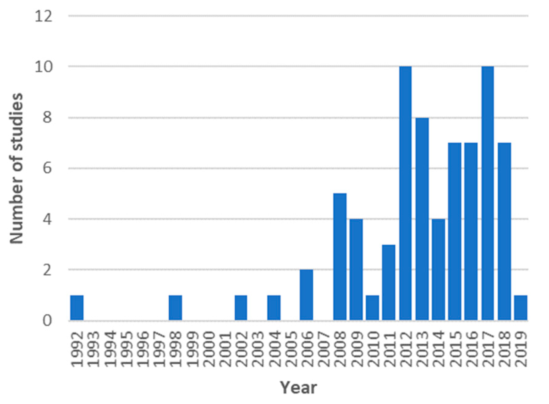
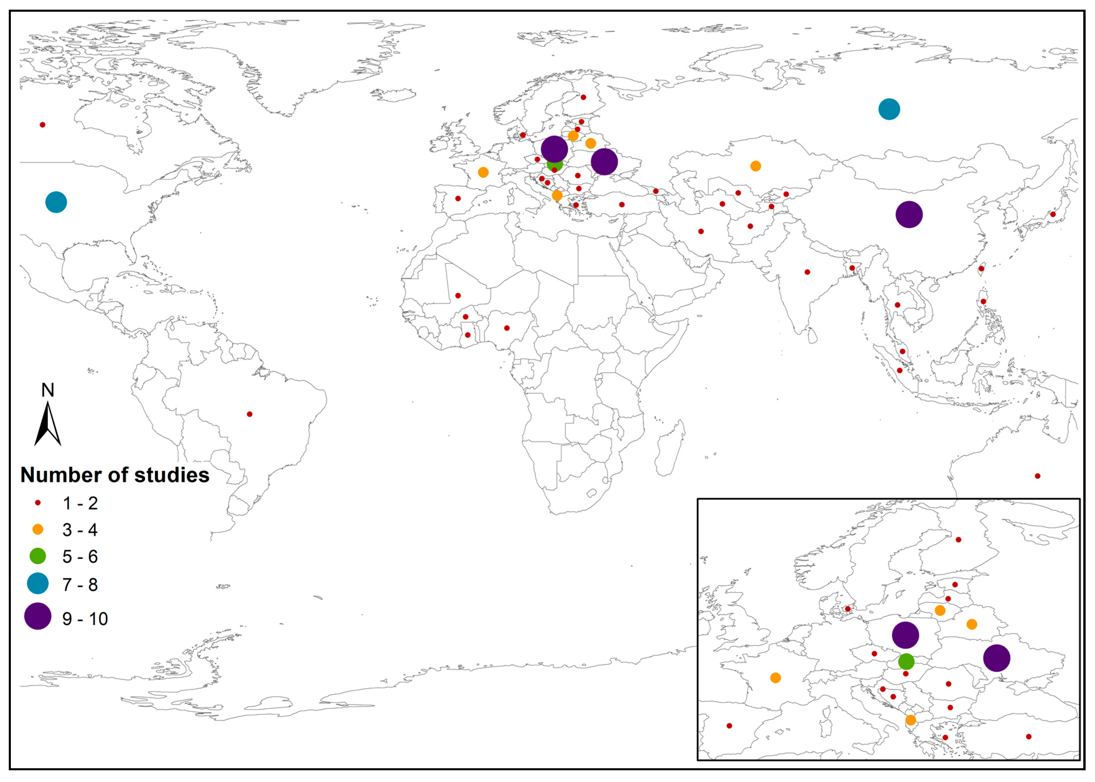
3.1. Location of Analyzed Studies

Several areas of interest were identified during the expert analysis (Figure 3). Most of the studies were localized in Europe, North America, Russia, and China. Some studies investigated localities in Southeast Asia, Central Asia, the Sub-Saharan area of Africa, and equatorial South America.

3.2. Survey of Specified AAL Classes and Their Definition and Abandonment Process

Agricultural land abandonment, in the most general interpretation by the available literature, is defined when the agriculture land is not managed (not sawn, not tilled, not even in the case of crop cultivation, not mown, or not grazed in the case of meadows) [11], the formerly managed arable land and meadows are gradually replaced by unmanaged grass–herb formations and successive shrubs [10], or the agricultural land is not exploited for a minimum of five years [53]. Other definitions are based on the premise that it is a common LU change, making the accurate mapping of both location and time when agricultural abandonment occurred important for understanding its environmental and social outcomes [64]. Alcántara et al. [69] specified this process, asserting that it is the result of a land owner’s decision to reduce the intensity of use of land for agriculture (including grazing) for an undetermined period, based on either natural, socio-economic, or personal constraints. In our approach, we distinguished between agricultural land abandonment (process) and AAL (state, final condition).
Papers which did not consider AAL classes (Table 4), although specified by keywords as potential sources of information about these classes, remained in the list of references because during the analysis of their content, other content important for the evaluation of the literature (for instance, fusion of optical and microwave data) was established.
Several papers contained classes, which, by their significant physiognomic properties and the known change of the status based on LC/LU, may be considered AAL classes; for example, changes within the grassland/forest classes or arable land/grassland [6,35], AAL because of lowered productivity [66], production effectiveness in forests [28], initial re-growth of short biomass [96], and overgrowth by secondary vegetation [97].
The specification of one AAL class, directly defined by the authors, may be interpreted in various ways. For instance:
  • Land covered by successional vegetation at the time when satellite data were recorded [70];
  • Areas with proven phenology changes by the moderate resolution imaging spectroradiometer (MODIS) imagery [69];
  • Areas specified by the MODIS normalized difference vegetation index (NDVI) time series [11,37];
  • Arable land or managed grassland converted to permanently unmanaged grasslands [55];
  • Originally agricultural land, but not used for at least five years [53,72];
  • Arable land barren for two or more years to be abandoned, while arable land barren for less than one year (including) was defined as fallow [71];
  • Short-term-fallow land [76];
  • Arable land and pastures covered by early successional shrubs and trees [46];
  • Croplands and managed grasslands in use during the late 1980s, but converted to fallow land later (shrublands or young forests) [39];
  • Degraded land [73];
  • Unmanaged grasslands [77].
Examples of two or more AAL classes defined in the papers:
  • Disappeared vineyards (densely overgrown by shrubs and trees, and linear structures of grapevines are not recognizable any more) and abandoned vineyards (partially identifiable linear structures of grapevines) [32];
  • Fallow agricultural land (crops or managed grasslands replaced by unmanaged grasslands or shrublands) and afforested areas (crops and managed grassland that had a closed forest canopy) [10];
  • Arable land potentially abandoned, meadows and pastures potentially abandoned, mixed LU potentially abandoned, and permanent crops potentially abandoned [29];
  • AAL abandoned managed grasslands, non-managed grasslands, and shrubs [75].
Changes in LC/LU classes were probably the basic criterion (Table 5) used for the specification of classes and further estimation of the development of AAL, for instance, arable land → grassland, arable land → shrubland, arable land → abandoned land, managed grassland → unmanaged grassland, and unmanaged grasslands and shrubs → unmanaged land. This criterion appeared in as many as 15 evaluated studies (Table 5, LC/LU changes). Another important criterion applied to the specification of AAL classes (in seven studies; Table 5, NDVI changes) was NDVI changes in the context of their time series. The criterion of the change of arable land in a long-time horizon based on statistical data, historical maps, or long-term orders of RS data was applied in four papers. Another applied criterion was the definition of a particular time interval when the given arable land was not exploited (for instance, at least five years). The criterion for the specification of the AAL class directly included in the agricultural census was used in two papers (Table 5, Identification of AAL classes). Simulation of the potential occurrence of AAL (for instance, based on consideration of varied natural and socio-economic conditions) was also an important criterion (used in two studies; Table 5, Identification of potential occurrence of AAL). Assessment of biomass was used for the indirect determination of the AAL class in three papers, and the criteria were not exactly specified in three papers (Table 5, Indirectly considered AAL).

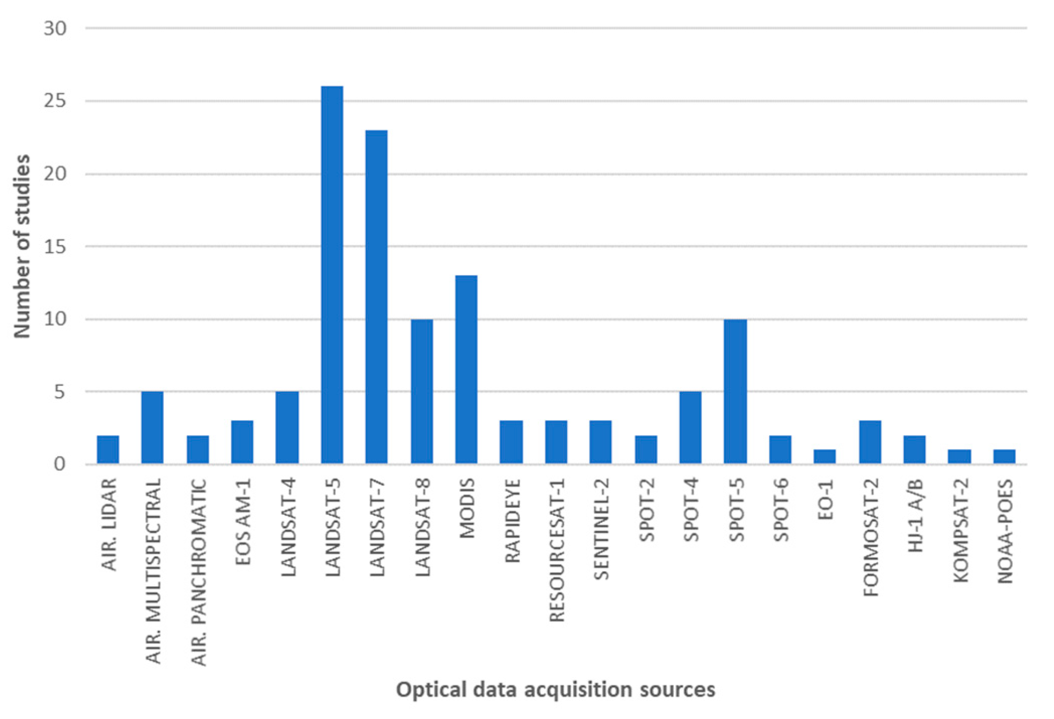
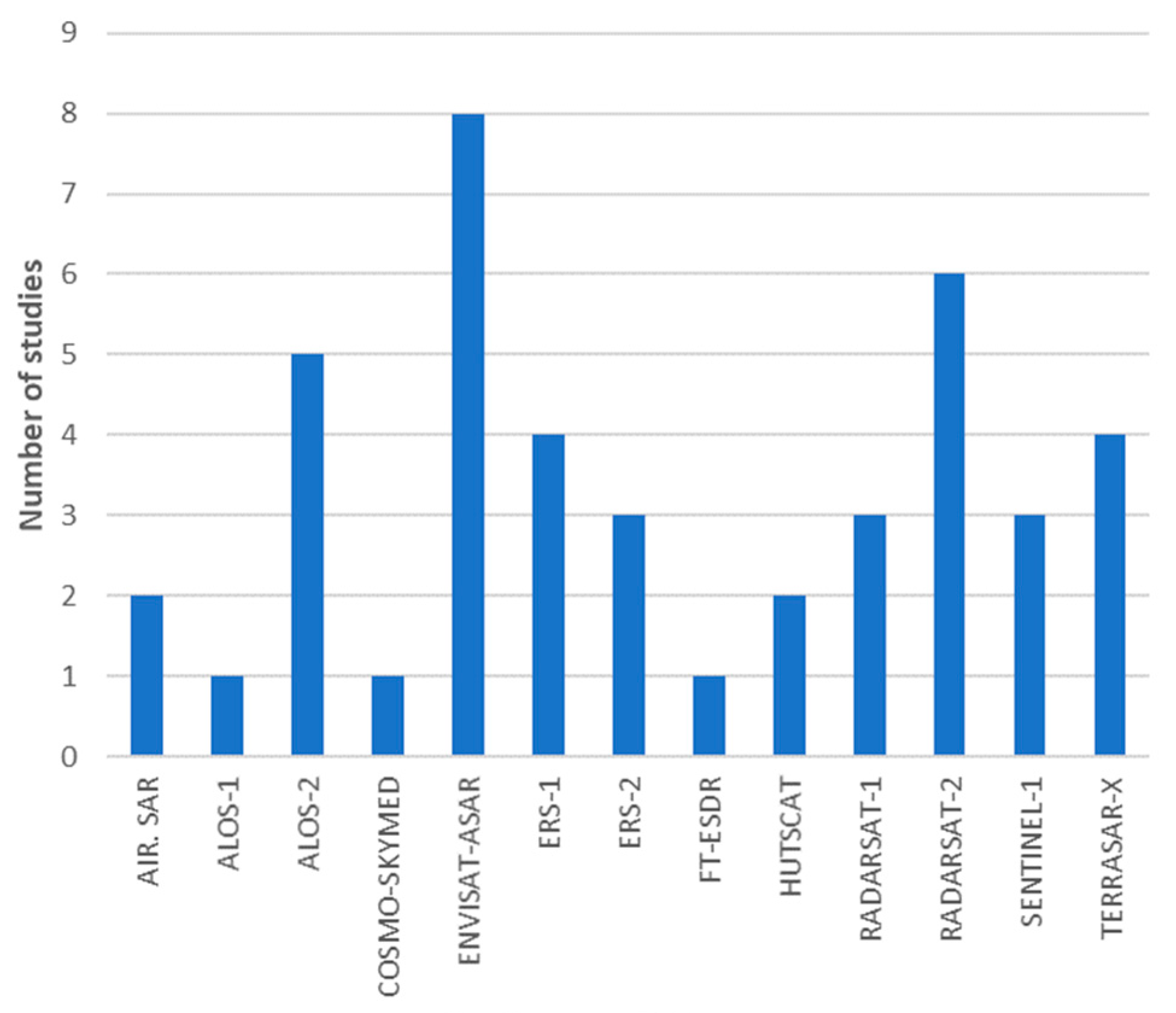
3.3. Satellite Data and Various Parts of the Electromagnetic Spectrum Used for AAL Identification

All 73 studies were categorized and generalized based on the general question ‘Data’ (Table 6) and further detailed into ST2.1 and ST2.2. (Figure 4 and Figure 5, respectively). According to those data, the Landsat, Terra Aqua, and SPOT programs were identified as the most frequently used data sources for the satellites with optical sensors, and Envisat-ASAR and RADARSAT-2 were identified as data sources for the satellites with microwave sensors. Sentinel-1 and Sentinel-2 data are increasingly used in European projects.
Landsat-5 and Landsat-7 data were used in the older studies analyzed concerning AAL identification, supported by multitemporal representation and wide availability. These data were often applied in combination with the MODIS data. The mentioned fusion of optical data (MODIS and Landsat) was connected with the supra-regional significance of studies conducted in study areas larger than 10 million km2 [11,28,30,37,70,75]. This fact also corresponded to the radiometric resolution of sensors, that is, the use of 30 m of spatial resolution in the case of Landsat project data or 250–500 m in the case of MODIS usage. Radiometric resolution of quoted satellites facilitated intensive tracking of LC heterogeneity. However, the textural and spectrally significant physiognomic indices, needed for a thorough distinction of AAL classes were lost with low spatial resolution data.
Studies which applied SPOT-5 or SPOT-6 data focused on testing procedures associated with the identification of AAL and LC/LU classes; for this reason, these studies worked with smaller key study sites (below 1000 km2) [29,44,52,54,56]. Studies using Sentinel-2 satellite data combined this with aerial data in study areas smaller than 750 km2 [50,67].

3.4. Methods for Identification of AAL Classes

The majority of the studies identified AAL (Figure 6) using object-based image analysis (OBIA) [32,35,49,54,56,76] and multitemporal analysis (MA) [47,52,58,61,74] methods. Most of the studies related to these methods combined different approaches. Most of them were connected with the vegetation index—NDVI: OBIA + NDVI [26,29,44] and MA + NDVI [37,43,69,73]. A significant amount of vegetation indices was used with the OBIA methods in a study by Liu et al. [51]. Six vegetation indices were used, but their usage in the process of AAL identification was limited. Other studies worked with the support-vector machine (SVM) classifier: OBIA + SVM [53] and MA + SVM [10,59,70]. Löw et al. [34] used the OBIA methods with a fusion of SVM and the random forest (RF) algorithm, resulting in significantly more accurate results than RF or SVM alone (overall accuracy increased by up to 7%). Hellesen and Matikainen [36] used OBIA with classification and regression trees to map shrub and tree cover in grassland habitats.
MA for mapping the secondary vegetation stands and clearings, using JERS-1 SAR data, was analyzed by Salas et al. [97]. Kuemmerle et al. [6] compared the combination of MA with supervised and unsupervised pixel-based approaches. Estel et al. [11] achieved a significant improvement by combining phenological profiles with multiple year NDVI time series data and the RF classification algorithms; overall accuracy reached 90.1%. A similar approach was selected by Griffiths et al. [65], who used RF on image composites and variance metrics, with the addition of the NDVI data series.
The application of machine learning algorithms, such as SVM or RF, supported by regression models or phenological aspects, is also a widely used method. An extensive analysis of machine learning algorithms in relationship with the classification of managed grasslands was performed by Dusseux et al. [77]. The separate usage of SVM algorithms, performed by Kuemmerle et al. [39], showed sufficient results for AAL identification, but the study was focused on carbon sequestration. Prishchepov et al. [75] compared the SVM algorithm with the maximum likelihood algorithm, exhibiting sufficient results for AAL identification using SVM. Prishchepov et al. [45] used an SVM classifier to monitor agricultural land abandonment using ImageSVM tool in IDL (interactive developing language) to select the optimal SVM parameterization automatically. They produced accurate LU/LC maps using multiseasonal imagery and the SVM change-detection approach. Prishchepov et al. [46] performed an effective combination of the SVM algorithm with logistic regression models. Another type of machine learning algorithm, named naïve Bayes classifier, was applied in a study by Lesiv et al. [72] in combination with several data inputs, including multitemporal Landsat and MODIS data. This study could be useful for the assessment of biogeochemical cycles (e.g., carbon dynamic) on abandoned and cultivated fields or for the analysis of the patterns and proximate causes of greening (vegetation recovery) and browning (vegetation degradation).
Other authors performed several methodological approaches for the classification of AAL. For this purpose, we refer to these studies as other combined methods for AAL identification using RS datasets: agricultural inventory with LU models [60], long-term inventory data with a cropland density map [30], multiple classification models [28], expert opinion with biophysical models [66], light detection and ranging (LiDAR) data and digital elevation model with ancillary data [63], hybrid classification: unsupervised iterative self-organizing data analysis technique (ISODATA) classification algorithm combined with supervised maximum likelihood algorithm [42], and ISODATA combined with the supervised classification approach and multitemporal images [96].
Finally, there were several studies dealing with SAR data. Correlation and machine learning regression were used in a study by Castillo et al. [67]. A computer-assisted photo interpretation (CAPI) with significant interference of the expert—interpreter opinion and field observation with SAR data usage—was performed in a study by Ray et al. [68]. This study revealed unusual polarization responses in AAL areas.
Spring observation is highly relevant to differentiate arable land and AAL, and this could be secured by the usage of SAR data. Moreover, SAR-based maps can be used to fill in temporal gaps in the classification process, where clouds and haze result in missing values [49]. The work of Stefanski et al. [49] created an object-based classification workflow using an RF classifier, resulting in five different LC/LU maps. SAR-based OBIA with simple classification was performed by Yusoff et al. [44]. The process of assigning classes to objects was done for each class separately with a trial and error approach. Dusseux et al. [77] showed that the combined use of optical and radar RS data was not efficient for grassland management identification. This study also identified the most discriminating variables (from several vegetation indices, biophysical variables, backscattering coefficients, and polarimetric discriminators) useful for grassland classification. AAL is challenging to identify because it is driven by both natural and social factors. It is usually fragmented and scattered to small abandoned land parcels [71]. This issue leads to various problems, which should be acknowledged (Table 7).

4. Discussion

In this paper, 73 studies listed in the references in the following three spheres were analyzed and assessed for: (i) definitions and criteria for the specification of AAL classes in the cited literature, (ii) satellite (both optical and microwave) data used in the context of identification and assessment of AAL classes documented in the quoted literature, and (iii) methods used for the identification of AAL classes in the cited literature.
Based on this review, the main analytical finding was the absence of a generally accepted AAL definition [71]. Moreover, different topics could be proposed for discussion: (i) analysis of large areas using medium-resolution RS data [45], (ii) usage of LC change maps for AAL identification, (iii) missing field surveys specially oriented to obtain significant features about AAL classes, (iv) long-term inventory data with average accuracy used for validation, and (v) the use of only spectral or spatial object properties [53].
The suggested vagueness in defining AAL classes was evident in the previous paragraph, and only a few sources specified a comprehensive AAL definition. This was essential for identifying and understanding the inner structure of progressive overgrowth change over time. It was necessary to characterize three basic classes of AAL [17] for the process of abandonment identification validated in Eastern Europe and similar regions (Table 8), based on overgrowth by the vegetation of various types, their tallness, density, and clustering. These physiognomic properties were perceived as carriers of spectral and textural information necessary for the discernibility of the so specified AAL classes in RS data.
Based on field research [17] of these basic classes and by the type of overgrown agricultural land (represented by arable land, meadows and pastures, and orchards and vineyards), it was possible to specify eight AAL sub-classes (Table 9).
The four physiognomic criteria used for the definition and specification of AAL classes could be relevant. Essential parts of their validation were field surveys defining the characteristic part of the abandonment of agricultural land in real conditions. Pointereau et al. [13] argued that in some cases, the estimation of AAL and fallow land (especially class AAL11) is difficult and a question of the declaration by the farmer. In such a case, useful data can be obtained from the Integrated Administration and Control System.
Studies involved with the criteria of LU/LC changes primarily concentrated on changes within the framework of identified classes. The accomplishment of such methodical steps did not require any thorough field survey. An important contribution to the given issue may be a thorough field survey, facilitating the exact specification of physiognomic criteria. The given procedure is the basic bottom-up classification approach offering an above-standard quality of processing the field data.
The physiognomic criteria, which would be obtained by a thorough field survey, however, did not enter the process in the analyzed and assessed publications. Presumably, the application of the proposed criteria, along with the phenological metrics (especially with NDVI time series), can contribute to the identification of AAL classes. The statistical analysis of quoted time series, based on correlation coefficients or standard deviation, may also be significant.
In conclusion, this review shows, that all of the analyzed papers identified AAL using an indirect approach. Most of the studies compared LC/LU data from different time horizons, NDVI time series, and different statistical databases (Table 5). Direct identification of AAL classes using RS data from the exact time horizon (single image) and based on prior defined interpretation features of AAL was missing.
The resulting process of AAL identification using satellite data and training data obtained from field surveys may be accomplished by object-based methods in combination with machine learning algorithms, preferably, SVM or RF.
Current research in abandonment identification focused on the global or sub-continental scale in terms of agriculture production assessment and carbon cycle contribution. The research focused on the local scale applied data with a high resolution of approximately 10 m in experimental sites smaller than 1 × 1 km. Another challenge in AAL determination is radar and optical data fusion, utilizing the advantages of both technologies. Currently, with the Sentinel-1 data and Sentinel-2 data (Landsat), we expect significant results and improvement for AAL class identification. The combination of other relevant sources performed by fusion with ALOS-2 or by adding the aerial imagery has led to the synergic use of multitemporal optical, microwave (backscatter, interferometry), and LiDAR data as the best combination in RS and the model-based semi-empirical approach [98].
The main challenges in AAL identification compared to the knowledge attained by analysis and evaluation of the cited literature are still open:
  • Enrichment of information potential of optical and radar data fusion by the data obtained from a detailed field survey;
  • The exact identification of AAL areas containing relevant characteristics about the nature of the overgrowing vegetation may contribute to the simulation of biomass volume in such areas;
  • Determination of suitable phenological season for AAL identification;
  • Biomass estimation;
  • Identification of driving forces causing the process of abandonment;
  • Determination of AAL classification rules;
  • Analysis of specific spectral, textural, and biophysical characteristics of AAL;
  • Verification of the exploitation of new Sentinel-1 (C-band) and ALOS-2 (L-band) radar sensors in various combinations of polarizations and combination with optical Sentinel-2 data in the AAL classification;
  • Verification of the chances to improve the resolution or pixel size working with the single look complex (SLC) data.

5. Conclusions

In this paper, 73 studies of world literature dealing with AAL identification using RS data were analyzed, which were supplemented by 25 sources used for a deeper understanding of the process of abandonment of agricultural land. We can conclude that the analyzed and evaluated studies, documenting mostly the abandonment of agricultural land and approaches to identify classes of overgrowing species, mostly did not consider detailed field surveys. Additionally, the identification and assessment of the natural vegetation overgrowth in AAL were also missing. The set of assessed studies provided the information base to obtain the missing information that facilitates the identification of AAL. In Eastern European countries, AAL has been more distinct since 1989 (Figure 3), manifesting the changes in the political, economic, and social situations in those countries.
A study providing a survey of knowledge about AAL is especially important for compliance with EU Regulation No. 2018/841 of the European Parliament and of the Council of 30 May 2018 [27] on the inclusion of greenhouse gas emissions and removal from LU, LU change, and forestry in the 2030 climate and energy framework. In order to obtain accurate accounts of emissions and removals in accordance with the 2006 IPCC Guidelines for National Greenhouse Gas Inventories (IPCC Guidelines), the annually reported values under Regulation (EU) No. 525/2013 of the European Parliament and of the Council for LU categories and the conversion between LU categories should be utilized. Compliance with the directive will also require the recording of LU changes. One of them is the abandonment of agricultural land. A survey of studies involved with this theme may be a valuable basic material for the preparation of a strategy for the fulfilment of the quoted directive.
The precise measurement of thickness and tallness of trees or shrubs on AAL is essential not only to AAL class definition, but to selection and calculation of which the models of woody biomass are most suitable for AAL biomass estimation on carbon storage. The drawback of many studies using the Sentinel-1 data is that they were limited to the ground range detected product, which has a lower resolution and does not work at all with the phase component. This can be overcome by using single look complex (SLC) data, which require certain programmer skills in the preparation and conversion of SLC data into specialized software (e.g., SNAP) and for the creation of stack files. The advantage of this approach is that it enables better, more complex, and controllable determination of backscatter parameters. Available time orders of Sentinel data make it possible to apply dual polarimetry and to check the time course of parameters related to biomass quantification in the frame of tracked AAL classes.

Author Contributions

All authors were equally involved in reading the articles reviewed in this study and contributed to writing this review. T.G. categorized the materials and, with the contribution of J.F., created an analysis for drafting and revising the manuscript.

Funding

This research was funded by the Government of Slovakia through an ESA Contract No. 4000123812/18/NL/SC under PECS (Plan for the European Cooperating States). The views expressed herein can in no way be taken to reflect the official opinion of the European Space Agency.

Acknowledgments

We would like to thank Jiangui Liu for valuable comments before the first submission of this review. Several anonymous reviewers and editor are thanked for their helpful comments that helped us to improve this paper. The authors also thank Hana Contrerasová for translations and linguistic help. The review was proofread by Proof-Reading-Service.com Ltd. in October 2019.

Conflicts of Interest

The authors declare no conflict of interest.

References

  1. Ustaoglu, E.; Collier, M.J. Farmland abandonment in Europe: An overview of drivers, consequences, and assessment of the sustainability implications. Environ. Rev. 2018, 26, 396–416. [Google Scholar] [CrossRef]
  2. Rey Benayas, J.; Martins, A.; Nicolau, J.M.; Schulz, J.J. Abandonment of agricultural land: An overview of drivers and consequences. CAB Rev. Perspect. Agric. Vet. Sci. Nutr. Nat. Resour. 2007, 2. [Google Scholar] [CrossRef]
  3. Suziedelyte Visockiene, J.; Tumeliene, E.; Maliene, V. Analysis and identification of abandoned agricultural land using remote sensing methodology. Land Use Policy 2019, 82, 709–715. [Google Scholar] [CrossRef]
  4. Baumann, M.; Kuemmerle, T.; Elbakidze, M.; Ozdogan, M.; Radeloff, V.C.; Keuler, N.S.; Prishchepov, A.V.; Kruhlov, I.; Hostert, P. Patterns and drivers of post-socialist farmland abandonment in Western Ukraine. Land Use Policy 2011, 28, 552–562. [Google Scholar] [CrossRef]
  5. Müller, D.; Kuemmerle, T.; Rusu, M.; Griffiths, P. Lost in transition: Determinants of post-socialist cropland abandonment in Romania. J. Land Use Sci. 2009, 4, 109–129. [Google Scholar] [CrossRef]
  6. Kuemmerle, T.; Müller, D.; Griffiths, P.; Rusu, M. Land use change in Southern Romania after the collapse of socialism. Reg. Environ. Chang. 2009, 9, 1–12. [Google Scholar] [CrossRef]
  7. Meyfroidt, P.; Schierhorn, F.; Prishchepov, A.V.; Müller, D.; Kuemmerle, T. Drivers, constraints and trade-offs associated with recultivating abandoned cropland in Russia, Ukraine and Kazakhstan. Glob. Environ. Chang. 2016, 37, 1–15. [Google Scholar] [CrossRef]
  8. Ioffe, G.; Nefedova, T.; Zaslavsky, I. From spatial continuity to fragmentation: The case of Russian farming. Ann. Assoc. Am. Geogr. 2004, 94, 913–943. [Google Scholar] [CrossRef]
  9. Renwick, A.; Jansson, T.; Verburg, P.H.; Revoredo-Giha, C.; Britz, W.; Gocht, A.; McCracken, D. Policy reform and agricultural land abandonment in the EU. Land Use Policy 2013, 30, 446–457. [Google Scholar] [CrossRef]
  10. Kuemmerle, T.; Hostert, P.; Radeloff, V.C.; Linden, S.; Perzanowski, K.; Kruhlov, I. Cross-border Comparison of Post-socialist Farmland Abandonment in the Carpathians. Ecosystems 2008, 11, 614–628. [Google Scholar] [CrossRef]
  11. Estel, S.; Kuemmerle, T.; Alcántara, C.; Levers, C.; Prishchepov, A.V.; Hostert, P. Mapping farmland abandonment and recultivation across Europe using MODIS NDVI time series. Remote Sens. Environ. 2015, 163, 312–325. [Google Scholar] [CrossRef]
  12. Lasanta, T.; Arnáez, J.; Pascual, N.; Ruiz-Flaño, P.; Errea, M.P.; Lana-Renault, N. Space–time process and drivers of land abandonment in Europe. CATENA 2017, 149, 810–823. [Google Scholar] [CrossRef]
  13. Pointereau, P.; Coulon, F.; Girard, P.; Lambotte, M.; Stuczynski, T.; Sanchez Ortega, V.; Del Rio, A. Analysis of Farmland Abandonment and the Extent and Location of Agricultural Areas that are Actually Abandoned or are in Risk to be Abandoned. In JCR Scientific and Technical Reports; European Commission Joint Research Centre, Institute for Environment and Sustainability Press: Luxembourg, 2008. [Google Scholar]
  14. FAO. FAOSTAT, Methods & Standards. Available online: http://www.fao.org/ag/agn/nutrition/Indicatorsfiles/Agriculture.pdf (accessed on 17 November 2019).
  15. Coppin, P.; Jonckheere, I.; Nackaerts, K.; Muys, B.; Lambin, E. Digital change detection methods in ecosystem monitoring: A review. Int. J. Remote Sens. 2004, 25, 1565–1596. [Google Scholar] [CrossRef]
  16. Feranec, J.; Hazeu, G.; Soukup, T. Interpretation of Satellite Images. In European Landscape Dynamics; Feranec, J., Soukup, T., Hazeu, G., Jaffrain, G., Eds.; CRC Press: Boca Raton, FL, USA, 2016; pp. 33–40. [Google Scholar]
  17. Feranec, J.; Szatmári, D.; Rusnák, M.; Pazúr, R.; Kopecká, M.; Oťaheľ, J.; Goga, T. Theoretical Base of Mapping an Abandoned Agricultural Land (Deliverable TN2). Available online: http://atbiomap.nlcsk.org/files/Deliverable_TN2-SK2-04 4000123812_ATBIOMAP.pdf (accessed on 17 November 2019).
  18. Feranec, J.; Kopecká, M.; Štych, P.; Bičík, I.; Soukup, T.; Jindrová, M.; Jupová, K. Changes of agricultural landscape in Central and Eastern Europe in 1990–2012. In Land Use/Cover Changes in Selected Regions in the World; Himiyama, Y., Bičík, I., Eds.; International Geographical Union Commission on Land Use/Land Cover Change: Asahikava, Japan, 2017; pp. 3–11. ISBN 978-4-907651-13-8. [Google Scholar]
  19. Taff, G.N.; Müller, D.; Kuemmerle, T.; Ozdeneral, E.; Walsh, S.J. Reforestation in Central and Eastern Europe After the Breakdown of Socialism. In Reforesting Landscapes; Nagendra, H., Southworth, J., Eds.; Springer: Dordrecht, The Netherlands, 2009; pp. 121–147. ISBN 978-1-4020-9656-3. [Google Scholar]
  20. Angelstam, P.; Boresjö-Bronge, L.; Mikusiński, G.; Sporrong, U.; Wästfelt, A. Assessing Village Authenticity with Satellite Images: A Method to Identify Intact Cultural Landscapes in Europe. AMBIO A J. Hum. Environ. 2003, 32, 594–604. [Google Scholar] [CrossRef]
  21. Kozak, J.; Estreguil, C.; Troll, M. Forest cover changes in the northern Carpathians in the 20th century: A slow transition. J. Land Use Sci. 2007, 2, 127–146. [Google Scholar] [CrossRef]
  22. Bičík, I.; Jeleček, L.; Kabrda, J.; Kupková, L.; Lipský, Z.; Mareš, P.; Šefrna, L.; Štych, P.; Winklerová, J. Vývoj Využití Ploch v Česku; Edice Geographica: Praha, Czech Republic, 2012; ISBN 978-80-904521-3-8. [Google Scholar]
  23. Gabrovec, M.; Kladnik, D. Some new aspects of land use in Slovenia. Geogr. Slov. 1997, 37, 7–64. [Google Scholar]
  24. Pazúr, R.; Lieskovský, J.; Feranec, J.; Oťaheľ, J. Spatial determinants of abandonment of large-scale arable lands and managed grasslands in Slovakia during the periods of post-socialist transition and European Union accession. Appl. Geogr. 2014, 54, 118–128. [Google Scholar] [CrossRef]
  25. Levers, C.; Schneider, M.; Prishchepov, A.V.; Estel, S.; Kuemmerle, T. Spatial variation in determinants of agricultural land abandonment in Europe. Sci. Total Environ. 2018, 644, 95–111. [Google Scholar] [CrossRef]
  26. Li, W.; Wang, S.; Zhou, Y.; Xu, Q.; Wang, F.; Han, Y. Remote sensing methods for surveying and extracting abandoned farmlands. In Proceedings of the 2012 5th International Congress on Image and Signal Processing, Chongqing, China, 16–18 October 2012; pp. 1086–1090. [Google Scholar]
  27. Regulation (EU) 2018/841 of the European Parliament and of the Council of 30 May 2018 on the Inclusion of Greenhouse Gas Emissions and Removals from Land Use, Land Use Change and Forestry in the 2030 Climate and Energy Framework, and Amending Regulation. Available online: http://data.europa.eu/eli/reg/2018/841/oj (accessed on 17 November 2019).
  28. Wang, C.; Gao, Q.; Wang, X.; Yu, M. Spatially differentiated trends in urbanization, agricultural land abandonment and reclamation, and woodland recovery in Northern China. Sci. Rep. 2016, 6, 37658. [Google Scholar] [CrossRef]
  29. Milenov, P.; Vassilev, V.; Vassileva, A.; Radkov, R.; Samoungi, V.; Dimitrov, Z.; Vichev, N. Monitoring of the risk of farmland abandonment as an efficient tool to assess the environmental and socio-economic impact of the Common Agriculture Policy. Int. J. Appl. Earth Obs. Geoinf. 2014, 32, 218–227. [Google Scholar] [CrossRef]
  30. Yu, Z.; Lu, C. Historical cropland expansion and abandonment in the continental U.S. during 1850 to 2016. Glob. Ecol. Biogeogr. 2018, 27, 322–333. [Google Scholar] [CrossRef]
  31. Schweers, W.; Bai, Z.; Campbell, E.; Hennenberg, K.; Fritsche, U.; Mang, H.-P.; Lucas, M.; Li, Z.; Scanlon, A.; Chen, H.; et al. Identification of potential areas for biomass production in China: Discussion of a recent approach and future challenges. Biomass Bioenergy 2011, 35, 2268–2279. [Google Scholar] [CrossRef]
  32. Karlík, L.; Gábor, M.; Falťan, V.; Lauko, V. Monitoring využívania vinohradníckych plôch: Prípadová štúdia Modra (Slovensko). Geogr. Cassoviensis 2017, 11, 22–32. [Google Scholar]
  33. Ioffe, G.; Nefedova, T.; Kirsten, D.B. Land Abandonment in Russia. Eurasian Geogr. Econ. 2012, 53, 527–549. [Google Scholar] [CrossRef]
  34. Löw, F.; Fliemann, E.; Abdullaev, I.; Conrad, C.; Lamers, J.P.A. Mapping abandoned agricultural land in Kyzyl-Orda, Kazakhstan using satellite remote sensing. Appl. Geogr. 2015, 62, 377–390. [Google Scholar] [CrossRef]
  35. Cvitanović, M.; Lučev, I.; Fürst-Bjeliš, B.; Borčić, L.S.; Horvat, S.; Valožić, L. Analyzing post-socialist grassland conversion in a traditional agricultural landscape—Case study Croatia. J. Rural Stud. 2017, 51, 53–63. [Google Scholar] [CrossRef]
  36. Hellesen, T.; Matikainen, L. An Object-Based Approach for Mapping Shrub and Tree Cover on Grassland Habitats by Use of LiDAR and CIR Orthoimages. Remote Sens. 2013, 5, 558–583. [Google Scholar] [CrossRef]
  37. Estel, S.; Kuemmerle, T.; Levers, C.; Baumann, M.; Hostert, P. Mapping cropland-use intensity across Europe using MODIS NDVI time series. Environ. Res. Lett. 2016, 11, 024015. [Google Scholar] [CrossRef]
  38. Campbell, J.E.; Lobell, D.B.; Genova, R.C.; Field, C.B. The Global Potential of Bioenergy on Abandoned Agriculture Lands. Environ. Sci. Technol. 2008, 42, 5791–5794. [Google Scholar] [CrossRef]
  39. Kuemmerle, T.; Olofsson, P.; Chaskovskyy, O.; Baumann, M.; Ostapowicz, K.; Woodcock, C.E.; Houghton, R.A.; Hostert, P.; Keeton, W.S.; Radeloff, V.C. Post-Soviet farmland abandonment, forest recovery, and carbon sequestration in western Ukraine. Glob. Chang. Biol. 2011, 17, 1335–1349. [Google Scholar] [CrossRef]
  40. Zomeni, M.; Tzanopoulos, J.; Pantis, J.D. Historical analysis of landscape change using remote sensing techniques: An explanatory tool for agricultural transformation in Greek rural areas. Landsc. Urban Plan. 2008, 86, 38–46. [Google Scholar] [CrossRef]
  41. Löw, F.; Prishchepov, A.V.; Waldner, F.; Dubovyk, O.; Akramkhanov, A.; Biradar, C.; Lamers, J. Mapping Cropland Abandonment in the Aral Sea Basin with MODIS Time Series. Remote Sens. 2018, 10, 159. [Google Scholar] [CrossRef]
  42. Kuemmerle, T.; Radeloff, V.C.; Perzanowski, K.; Hostert, P. Cross-border comparison of land cover and landscape pattern in Eastern Europe using a hybrid classification technique. Remote Sens. Environ. 2006, 103, 449–464. [Google Scholar] [CrossRef]
  43. Terekhin, E.A. Recognition of abandoned agricultural lands using seasonal NDVI values. Comput. Opt. 2017, 41, 719–725. [Google Scholar] [CrossRef] [Green Version]
  44. Yusoff, N.M.; Muharam, F.M.; Khairunniza-Bejo, S. Towards the use of remote-sensing data for monitoring of abandoned oil palm lands in Malaysia: A semi-automatic approach. Int. J. Remote Sens. 2017, 38, 432–449. [Google Scholar] [CrossRef]
  45. Prishchepov, A.V.; Radeloff, V.C.; Baumann, M.; Kuemmerle, T.; Müller, D. Effects of institutional changes on land use: Agricultural land abandonment during the transition from state-command to market-driven economies in post-Soviet Eastern Europe. Environ. Res. Lett. 2012, 7, 024021. [Google Scholar] [CrossRef]
  46. Prishchepov, A.V.; Müller, D.; Dubinin, M.; Baumann, M.; Radeloff, V.C. Determinants of agricultural land abandonment in post-Soviet European Russia. Land Use Policy 2013, 30, 873–884. [Google Scholar] [CrossRef] [Green Version]
  47. Müller, D.; Munroe, D.K. Changing Rural Landscapes in Albania: Cropland Abandonment and Forest Clearing in the Postsocialist Transition. Ann. Assoc. Am. Geogr. 2008, 98, 855–876. [Google Scholar] [CrossRef]
  48. Peterson, U.; Aunap, R. Changes in agricultural land use in Estonia in the 1990s detected with multitemporal Landsat MSS imagery. Landsc. Urban Plan. 1998, 41, 193–201. [Google Scholar] [CrossRef]
  49. Stefanski, J.; Chaskovskyy, O.; Waske, B. Mapping and monitoring of land use changes in post-Soviet western Ukraine using remote sensing data. Appl. Geogr. 2014, 55, 155–164. [Google Scholar] [CrossRef]
  50. Szostak, M.; Hawryło, P.; Piela, D. Using of Sentinel-2 images for automation of the forest succession detection. Eur. J. Remote Sens. 2018, 51, 142–149. [Google Scholar] [CrossRef]
  51. Liu, N.; Harper, R.; Handcock, R.; Evans, B.; Sochacki, S.; Dell, B.; Walden, L.; Liu, S. Seasonal Timing for Estimating Carbon Mitigation in Revegetation of Abandoned Agricultural Land with High Spatial Resolution Remote Sensing. Remote Sens. 2017, 9, 545. [Google Scholar] [CrossRef] [Green Version]
  52. Kanianska, R.; Kizeková, M.; Nováček, J.; Zeman, M. Land-use and land-cover changes in rural areas during different political systems: A case study of Slovakia from 1782 to 2006. Land Use Policy 2014, 36, 554–566. [Google Scholar] [CrossRef]
  53. Goodin, D.G.; Anibas, K.L.; Bezymennyi, M. Mapping land cover and land use from object-based classification: An example from a complex agricultural landscape. Int. J. Remote Sens. 2015, 36, 4702–4723. [Google Scholar] [CrossRef]
  54. Wang, S.X.; Li, W.J.; Zhou, Y.; Wang, F.T.; Xu, Q.L. Object-oriented Classification Technique for Extracting Abandoned Farmlands by Using Remote Sensing Images. In Proceedings of the 3rd International Conference on Multimedia Technology, Guangzhou, China, 29 November–1 December 2013; pp. 1497–1504. [Google Scholar]
  55. Alix-Garcia, J.; Kuemmerle, T.; Radeloff, V.C. Prices, Land Tenure Institutions, and Geography: A Matching Analysis of Farmland Abandonment in Post-Socialist Eastern Europe. Land Econ. 2012, 88, 425–443. [Google Scholar] [CrossRef]
  56. Yusoff, N.M.; Muharam, F.M.; Takeuchi, W.; Darmawan, S.; Abd Razak, M.H. Phenology and classification of abandoned agricultural land based on ALOS-1 and 2 PALSAR multi-temporal measurements. Int. J. Digit. Earth 2017, 10, 155–174. [Google Scholar] [CrossRef]
  57. Witmer, F.D.W. Detecting war-induced abandoned agricultural land in northeast Bosnia using multispectral, multitemporal Landsat TM imagery. Int. J. Remote Sens. 2008, 29, 3805–3831. [Google Scholar] [CrossRef]
  58. Baxter, R.E.; Calvert, K.E. Estimating Available Abandoned Cropland in the United States: Possibilities for Energy Crop Production. Ann. Am. Assoc. Geogr. 2017, 107, 1162–1178. [Google Scholar] [CrossRef]
  59. Müller, D.; Leitão, P.J.; Sikor, T. Comparing the determinants of cropland abandonment in Albania and Romania using boosted regression trees. Agric. Syst. 2013, 117, 66–77. [Google Scholar] [CrossRef]
  60. Campbell, J.E.; Lobell, D.B.; Genova, R.C.; Zumkehr, A.; Field, C.B. Seasonal energy storage using bioenergy production from abandoned croplands. Environ. Res. Lett. 2013, 8, 035012. [Google Scholar] [CrossRef]
  61. Wang, H.; Qiu, F.; Ruan, X. Loss or gain: A spatial regression analysis of switching land conversions between agriculture and natural land. Agric. Ecosyst. Environ. 2016, 221, 222–234. [Google Scholar] [CrossRef]
  62. Sedlar, Z.; Alegro, A.; Radović, A.; Brigić, A.; Hršak, V. Extreme land-cover and biodiversity change as an outcome of land abandonment on a Mediterranean island (eastern Adriatic). Plant Biosyst. 2018, 152, 728–737. [Google Scholar] [CrossRef]
  63. Kolecka, N.; Kozak, J.; Kaim, D.; Dobosz, M.; Ginzler, C.; Psomas, A. Mapping Secondary Forest Succession on Abandoned Agricultural Land in the Polish Carpathians. ISPRS Int. Arch. Photogramm. Remote Sens. Spat. Inf. Sci. 2016, 41, 931–935. [Google Scholar] [CrossRef]
  64. Yin, H.; Prishchepov, A.V.; Kuemmerle, T.; Bleyhl, B.; Buchner, J.; Radeloff, V.C. Mapping agricultural land abandonment from spatial and temporal segmentation of Landsat time series. Remote Sens. Environ. 2018, 210, 12–24. [Google Scholar] [CrossRef]
  65. Griffiths, P.; Müller, D.; Kuemmerle, T.; Hostert, P. Agricultural land change in the Carpathian ecoregion after the breakdown of socialism and expansion of the European Union. Environ. Res. Lett. 2013, 8, 045024. [Google Scholar] [CrossRef]
  66. Gibbs, H.K.; Salmon, J.M. Mapping the world’s degraded lands. Appl. Geogr. 2015, 57, 12–21. [Google Scholar] [CrossRef]
  67. Castillo, J.A.A.; Apan, A.A.; Maraseni, T.N.; Salmo, S.G. Estimation and mapping of above-ground biomass of mangrove forests and their replacement land uses in the Philippines using Sentinel imagery. ISPRS J. Photogramm. Remote Sens. 2017, 134, 70–85. [Google Scholar] [CrossRef]
  68. Ray, T.W.; Farr, T.G.; van Zyl, J.J. Detection of land degradation with polarimetric SAR. Geophys. Res. Lett. 1992, 19, 1587–1590. [Google Scholar] [CrossRef]
  69. Alcantara, C.; Kuemmerle, T.; Prishchepov, A.V.; Radeloff, V.C. Mapping abandoned agriculture with multi-temporal MODIS satellite data. Remote Sens. Environ. 2012, 124, 334–347. [Google Scholar] [CrossRef]
  70. Alcantara, C.; Kuemmerle, T.; Baumann, M.; Bragina, E.V.; Griffiths, P.; Hostert, P.; Knorn, J.; Müller, D.; Prishchepov, A.V.; Schierhorn, F.; et al. Mapping the extent of abandoned farmland in Central and Eastern Europe using MODIS time series satellite data. Environ. Res. Lett. 2013, 8, 035035. [Google Scholar] [CrossRef]
  71. Xiao, G.; Zhu, X.; Hou, C.; Xia, X. Extraction and analysis of abandoned farmland: A case study of Qingyun and Wudi counties in Shandong Province. J. Geogr. Sci. 2019, 29, 581–597. [Google Scholar] [CrossRef] [Green Version]
  72. Lesiv, M.; Schepaschenko, D.; Moltchanova, E.; Bun, R.; Dürauer, M.; Prishchepov, A.V.; Schierhorn, F.; Estel, S.; Kuemmerle, T.; Alcántara, C.; et al. Spatial distribution of arable and abandoned land across former Soviet Union countries. Sci. Data 2018, 5, 180056. [Google Scholar] [CrossRef] [PubMed]
  73. Tong, X.; Brandt, M.; Hiernaux, P.; Herrmann, S.M.; Tian, F.; Prishchepov, A.V.; Fensholt, R. Revisiting the coupling between NDVI trends and cropland changes in the Sahel drylands: A case study in western Niger. Remote Sens. Environ. 2017, 191, 286–296. [Google Scholar] [CrossRef] [Green Version]
  74. Müller, D.; Sikor, T. Effects of postsocialist reforms on land cover and land use in South-Eastern Albania. Appl. Geogr. 2006, 26, 175–191. [Google Scholar] [CrossRef]
  75. Prishchepov, A.V.; Radeloff, V.C.; Dubinin, M.; Alcantara, C. The effect of Landsat ETM/ETM+ image acquisition dates on the detection of agricultural land abandonment in Eastern Europe. Remote Sens. Environ. 2012, 126, 195–209. [Google Scholar] [CrossRef]
  76. Guenthert, S.; Siegmund, A.; Thunig, H.; Michel, U. Object-based detection of LUCC with special regard to agricultural abandonment on Tenerife (Canary Islands). Earth Resour. Environ. Remote Sens./GIS Appl. II 2011, 8181, 1–7. [Google Scholar] [CrossRef]
  77. Dusseux, P.; Gong, X.; Corpetti, T.; Hubert-Moy, L.; Corgne, S. Contribution of radar images for grassland management identification. In Proceedings of the SPIE Remote Sensing, Edinburgh, UK, 24–27 September 2012; Volume 8531. [Google Scholar]
  78. Forkuor, G.; Conrad, C.; Thiel, M.; Landmann, T.; Barry, B. Evaluating the sequential masking classification approach for improving crop discrimination in the Sudanian Savanna of West Africa. Comput. Electron. Agric. 2015, 118, 380–389. [Google Scholar] [CrossRef]
  79. Ozdarici, O.A.; Akyurek, Z.A. segment-based approach to classify agricultural lands by using multi-temporal optical and microwave data. Int. J. Remote Sens. 2012, 33, 7184–7204. [Google Scholar] [CrossRef]
  80. Hajj, M.E.; Baghdadi, N.; Cheviron, B.; Belaud, G.; Zribi, M. Integration of remote sensing derived parameters in a crop model: Case of hay. In Proceedings of the 2016 IEEE International Geoscience and Remote Sensing Symposium (IGARSS), Beijing, China, 10–15 July 2016; pp. 7149–7152. [Google Scholar]
  81. Surek, G.; Nádor, G.; Fényes, D.; Vasas, L. Monitoring of western corn rootworm damage in maize fields by using integrated radar (ALOS PALSAR) and optical (IRS LISS, AWiFS) satellite data. Geocarto Int. 2013, 28, 63–79. [Google Scholar] [CrossRef]
  82. Abdikan, S.; Sanli, F.B.; Esetlili, M.T.; Kurucu, Y. Land use/cover mapping using multisensor image fusion technique. Remote Sens. Chang. Eur. 2009, 157–164. [Google Scholar] [CrossRef]
  83. Koppe, W.; Gnyp, M.L.; Hennig, S.D.; Li, F.; Miao, Y.; Chen, X.; Jia, L.; Bareth, G. Multi-Temporal Hyperspectral and Radar Remote Sensing for Estimating Winter Wheat Biomass in the North China Plain. Photogramm. Fernerkund. Geoinf. 2012, 2012, 281–298. [Google Scholar] [CrossRef]
  84. Hütt, C.; Koppe, W.; Miao, Y.; Bareth, G. Best accuracy land use/land cover (LULC) classification to derive crop types using multitemporal, multisensor, and multi-polarization SAR satellite images. Remote Sens. 2016, 8, 684. [Google Scholar] [CrossRef] [Green Version]
  85. Wang, Y.C.; Feng, C.C.; Vu Duc, H. Integrating Multi-Sensor Remote Sensing Data for Land Use/Cover Mapping in a Tropical Mountainous Area in Northern Thailand. Geogr. Res. 2012, 50, 320–331. [Google Scholar] [CrossRef]
  86. Laurila, H.; Karjalainen, M.; Hyyppä, J.; Kleemola, J. Integrating Vegetation Indices Models and Phenological Classification with Composite SAR and Optical Data for Cereal Yield Estimation in Finland (Part I). Remote Sens. 2009, 2, 76–114. [Google Scholar] [CrossRef] [Green Version]
  87. Pal, M.; Mather, P.M. The use of InSAR texture features in land use classification. In Proceedings of the 22nd EARSeL Symposium, Prague, Czech Republic, 4–6 June 2002; pp. 49–56. [Google Scholar]
  88. Mosleh, M.; Hassan, Q.; Chowdhury, E. Application of Remote Sensors in Mapping Rice Area and Forecasting Its Production: A Review. Sensors 2015, 15, 769–791. [Google Scholar] [CrossRef] [PubMed] [Green Version]
  89. Jin, X.; Yang, G.; Xu, X.; Yang, H.; Feng, H.; Li, Z.; Shen, J.; Zhao, C.; Lan, Y. Combined multi-temporal optical and radar parameters for estimating LAI and biomass in winter wheat using HJ and RADARSAR-2 data. Remote Sens. 2015, 7, 13251–13272. [Google Scholar] [CrossRef] [Green Version]
  90. Fieuzal, R.; Marais Sicre, C.; Baup, F. Estimation of corn yield using multi-temporal optical and radar satellite data and artificial neural networks. Int. J. Appl. Earth Obs. Geoinf. 2017, 57, 14–23. [Google Scholar] [CrossRef]
  91. Qi, J.; Wang, C.; Inoue, Y.; Zhang, R.; Gao, W. Synergy of optical and radar remote sensing in agricultural applications. In Proceedings of the Optical Science and Technology, SPIE’S 48th Annual Meeting, San Diego, CA, USA, 3–8 August 2003; Volume 5153, p. 153. [Google Scholar]
  92. Kussul, N.; Lemoine, G.; Gallego, F.J.; Skakun, S.V.; Lavreniuk, M.; Shelestov, A.Y. Parcel-Based Crop Classification in Ukraine Using Landsat-8 Data and Sentinel-1A Data. IEEE J. Sel. Top. Appl. Earth Obs. Remote Sens. 2016, 9, 2500–2508. [Google Scholar] [CrossRef]
  93. Kim, Y.; Kimball, J.S.; Didan, K.; Henebry, G.M. Response of vegetation growth and productivity to spring climate indicators in the conterminous United States derived from satellite remote sensing data fusion. Agric. For. Meteorol. 2014, 194, 132–143. [Google Scholar] [CrossRef]
  94. McNairn, H.; Champagne, C.; Shang, J.; Holmstrom, D.; Reichert, G. Integration of optical and Synthetic Aperture Radar (SAR) imagery for delivering operational annual crop inventories. ISPRS J. Photogramm. Remote Sens. 2009, 64, 434–449. [Google Scholar] [CrossRef]
  95. Laurila, H.; Karjalainen, M.; Kleemola, J.; Hyyppä, J. Cereal Yield Modeling in Finland Using Optical and Radar Remote Sensing. Remote Sens. 2010, 2, 2185–2239. [Google Scholar] [CrossRef] [Green Version]
  96. Rignot, E.; Salas, W.A.; Skole, D.L. Mapping deforestation and secondary growth in Rondonia, Brazil, using imaging radar and thematic mapper data. Remote Sens. Environ. 1997, 59, 167–179. [Google Scholar] [CrossRef] [Green Version]
  97. Salas, W.A.; Ducey, M.J.; Rignot, E.; Skole, D. Assessment of JERS-1 SAR for monitoring secondary vegetation in Amazonia: II. Spatial, temporal, and radiometric considerations for operational monitoring. Int. J. Remote Sens. 2002, 23, 1381–1399. [Google Scholar] [CrossRef]
  98. Sinha, S.; Jeganathan, C.; Sharma, L.K.; Nathawat, M.S. A review of radar remote sensing for biomass estimation. Int. J. Environ. Sci. Technol. 2015, 12, 1779–1792. [Google Scholar] [CrossRef] [Green Version]
Figure 1. Flowchart of literature database processing.
Remotesensing 11 02759 g001
Figure 2. Annual publications of the analyzed documents.
Remotesensing 11 02759 g002
Figure 3. Locations of study sites in related studies selected for analysis according to each workflow.
Remotesensing 11 02759 g003
Figure 4. Satellites with optical sensors used in related studies selected for analysis according to each workflow (AIR. = airborne).
Remotesensing 11 02759 g004
Figure 5. Satellites with microwave sensors used in related studies selected for analysis according to each workflow (AIR. = airborne).
Remotesensing 11 02759 g005
Figure 6. Methods used for the identification of AAL.
Remotesensing 11 02759 g006
Table 1. Sample of modification of agricultural land use classes in the process of their abandonment (e.g., Slovakia) [17].
Agricultural Land UseOvergrown by
Arable landHerbaceous formations
Shrub and herbaceous formations
Tree, shrub, and herbaceous formations
Permanent cropsHerbaceous formations
Shrub and herbaceous formations
Tree, shrub, and herbaceous formations
Pastures and meadowsShrub formations
Tree and shrub formations
Table 2. Overview of the subject, search terms, and number of analyzed contributions.
SubjectSearch QueryNumber of StudiesStudy IDs
Agricultural abandonment using satellite remote sensingTS = ((agricultur* OR crop* OR farm*) AND abandon* AND land AND (remote sensing OR satellite))54[6,10,11,25,26,28,29,30,31,32,33,34,35,36,37,38,39,40,41,42,43,44,45,46,47,48,49,50,51,52,53,54,55,56,57,58,59,60,61,62,63,64,65,66,67,68,69,70,71,72,73,74,75,76]
Optical and radar remote sensing satellite data fusion according to agricultural abandonmentTS = ((radar OR microwave* OR SAR) AND optical AND remote sensing AND satellite AND (combin* OR fus* OR compar* OR integrat*) AND (agricult* OR crop* OR farm*))19[77,78,79,80,81,82,83,84,85,86,87,88,89,90,91,92,93,94,95]
Used field tag TS = Topic, and Boolean operators (AND, OR) to form and combine search queries. Queries are standardized according to the Web of Science Core Collection—Advanced search.
Table 3. Deep content analysis research questions.
General Task
Area
Data
Data resolution
Classes
Classification
Classification validation
Brief methodology
Key analysis
Specific Task
ST1.1: Which AAL classes were specified?
ST1.2: Based on which criteria were the AAL classes specified?
ST2.1: What data obtained in the optical part of the spectra were used?
ST2.2: What data obtained in the microwave part of the spectra were used?
ST2.3: Was the fusion of optical and radar data used?
ST3.1: What approaches to identification of AAL classes were used?
ST3.2: What was the precision of identification of AAL classes?
ST3.3: What were the benefits and drawbacks of applied approaches for the identification of AAL classes?
ST3.4: Do the analyzed papers prove that identification of AAL classes by applying optical and radar data is viable?
Table 4. Summary of abandoned agricultural land characterized in the contributions.
Classes AAL/LCLUNumber of StudiesStudy IDs
AALs were not considered26[31,33,36,40,42,50,57,62,78,79,80,81,82,83,84,85,86,87,88,89,90,91,92,93,94,95]
Class not directly tagged as AAL is only a result of LC/LU class change7[6,28,35,51,52,66,67]
One directly defined AAL class32[11,25,26,30,37,38,39,41,43,44,45,46,47,48,53,54,55,59,60,61,63,65,68,69,70,71,72,73,74,75,76,77]
Two or more defined AAL classes8[10,29,32,34,49,56,58,75]
Table 5. Criteria applied in the specification of abandoned agricultural land classes.
Criteria Used in Analyzed PapersNumber of StudiesStudy IDs
LC/LU changes
According to LC/LU attribute table
15[6,10,28,34,35,39,46,47,48,49,55,65,74,75,77]
NDVI changes
According to phenology change and time series analysis
7[11,37,43,44,69,70,73]
Specific time perspective horizon2[53,76]
Identification of potential occurrence of AAL
Secondary succession
2[26,63]
Changes of arable land in a long-time horizon4[30,38,58,60]
Identification of AAL classes
Taken over from agricultural census
2[52,66]
Fulfilled the following three basic conditions:
  • Used in the past (recorded as agricultural land in the Land Parcel Identification System)
  • Values of selected biophysical parameters (Geoland 2)
  • Heterogeneous cover (higher variance in reflectance)
1[29]
Indirectly considered AAL
By assessment of biomass
3[67,96,97]
Not exactly specified criteria
  • A priori selected abandoned agricultural land; its manifestation in radar record
  • Comparison of AAL classes on a photograph with etalon
5[28,51,54,56,68]
Table 6. Applied remote sensing data.
Used Remote Sensing DataNumber of StudiesStudy IDs
Optical remote sensing data42[6,10,11,26,28,29,30,31,32,33,34,35,37,39,40,41,43,44,45,46,47,48,50,51,52,53,54,57,59,61,62,64,65,66,69,70,71,72,73,74,75,76]
Radar remote sensing data4[36,68,87,89]
Optical and radar remote sensing data, although each was used independently4[42,63,67,95]
Combination of optical and radar remote sensing data18[49,56,77,78,79,80,81,82,83,84,85,86,88,90,91,92,93,94]
Compilation of classic statistical data5[25,38,55,58,60]
Table 7. Key findings and advantages of abandoned agricultural land identification using remote sensing data.
Analytical Findings/AdvantagesSample References
Combining multiseasonal RS data improve AAL classification[69]
Combining phenological profiles improve AAL classification[11]
Minimum NDVI values are more effective against mean NDVI values[43]
Shrub formations are an indicator for AAL identification (because shrub formations are not natural vegetation formations in the agriculture area)[42]
High-resolution statistical databases improve the estimation of AAL[38]
Integration of RS data with in situ data and the use of biophysical parameters improve AAL classification[29]
Carbon stocks correlate with canopy coverage and spectrally based vegetation indices[51]
Object-oriented classification rules contribute to AAL feature extraction[56]
Table 8. Definition of abandoned agricultural land classes [17].
General definitionAbandoned agricultural land (AAL) is land void of any activities associated with agricultural production until this land becomes overgrown by other than agricultural vegetation.
AAL1AAL overgrown by low vegetation(herbaceous formations): Originally agricultural land (arable land, vineyards, and orchards) overgrown by low to tall grasses and broad-leaved herbs. It develops without human intervention for more than three years, while it is not part of a fallow. Overgrowth of land by herbaceous formations >90% and their tallness oscillates between 0.5–1.5 m.
AAL2AAL overgrown by medium-sized vegetation (shrub formations): Originally agricultural land (arable land, meadows and pastures, vineyards and orchards) fully overgrown by grasses and broad-leaved herbs and shrubs with a canopy closure >20%, tallness of which is maximum 1.6–3.0 m. Sporadic trees are not identifiable on the Sentinel images (picture element 10 × 10 m).
AAL3AAL overgrown by tall vegetation (tree formations): Originally agricultural land (arable land, meadows and pastures, vineyards and orchards) fully overgrown by grasses and broad-leaved herbs and shrubs with a varied canopy closure and >20% trees; canopy taller than 3 m.
Table 9. Nomenclature of detailed classes AAL1, AAL2, and AAL3.
AAL1AAL11Arable land with herbaceous formations
AAL12Orchards = S and vineyards = V with herbaceous formations
AAL2AAL21Arable land with herbaceous/shrub formations
AAL22Meadows and pastures with shrub formations
AAL23Orchards = S and vineyards = V with shrub formations
AAL3AAL31Arable land with tree formations
AAL32Meadows and pastures with tree formations
AAL33Orchards = S and vineyards = V with tree formations

