Article

Geoheritage Values and Environmental Issues of Derelict Mines: Examples from the Sulfide Mines of Gromolo and Petronio Valleys (Eastern Liguria, Italy)

1
Department of Earth, Environmental and Life Sciences (DISTAV), University of Genova, C.so Europa, 26, I-16132 Genova, Italy
2
Department of Architecture and Design (DAD), University of Genova, Stradone S. Agostino, 37, I-16123 Genova, Italy
3
Associazione Radice Comune, Via di San Bernardo 34r, I-16123 Genova, Italy
4
GeoSectra SRL, Via Palmaria, 9/6 L, I-16121 Genova, Italy
*
Author to whom correspondence should be addressed.
Minerals 2018, 8(6), 229; https://doi.org/10.3390/min8060229
Submission received: 30 March 2018 / Revised: 18 May 2018 / Accepted: 24 May 2018 / Published: 28 May 2018
(This article belongs to the Special Issue Mineralogical Applications for Cultural Heritage)

Abstract

:
Derelict mining districts represent anthropogenically influenced landscapes that are often characterized by important geological, ecological, environmental, industrial, cultural, and archeological values. Nevertheless, after mining activities cease, several environmental problems are left behind, associated with soil and water pollution, hydrogeological instability, subsidence, ecosystem damages, and landscape degradation or devastation. In this article we present a case study focused on a sulfide mining district (Petronio and Gromolo valleys, Genova) located on the ophiolitic sequences of the Northern Apennines (Eastern Liguria, Italy), with the aim of applying a GIS (Geographic Information System)-based model for the complete census of derelict mines and for the assessment of their geoheritage and geotourist values, potential risks, and environmental impact. All information has been integrated to produce a multicriteria approach for the evaluation of hazards and/or critical issues and geoheritage values. Based on the results obtained in this pilot area, an integrated cultural and touristic route has been proposed, which combines several points of interest (POIs) chosen within an area of about 8 km2.

Graphical Abstract

1. Introduction

Derelict mines are highly problematic areas with several environmental issues and severe landscape degradation [1,2,3,4,5]. As highlighted by Bell and Donnelly (2006), “the degree of impact that mining has on the environment varies depending on the mineral worked, the method of working, the location, and size of the working” [4,6].
Despite their high environmental and landscape impact, abandoned mining sites may represent a potential source of income considering their possibility of being re-used as geoheritage and geotouristic (ecotouristic) resources after rehabilitation [7,8,9,10]. In fact, mining sites can rightfully be defined as geosites [7,11] because, other than cultural monuments of mining heritage, they (i) can provide access to geological rarities and spectacular scenery; (ii) allow a more comprehensive vision of geological features by unveiling the exposition of rocks, minerals, geological structures, and stratigraphic units [10]; and (iii) have several natural, ecological, and landscape potentials [7].

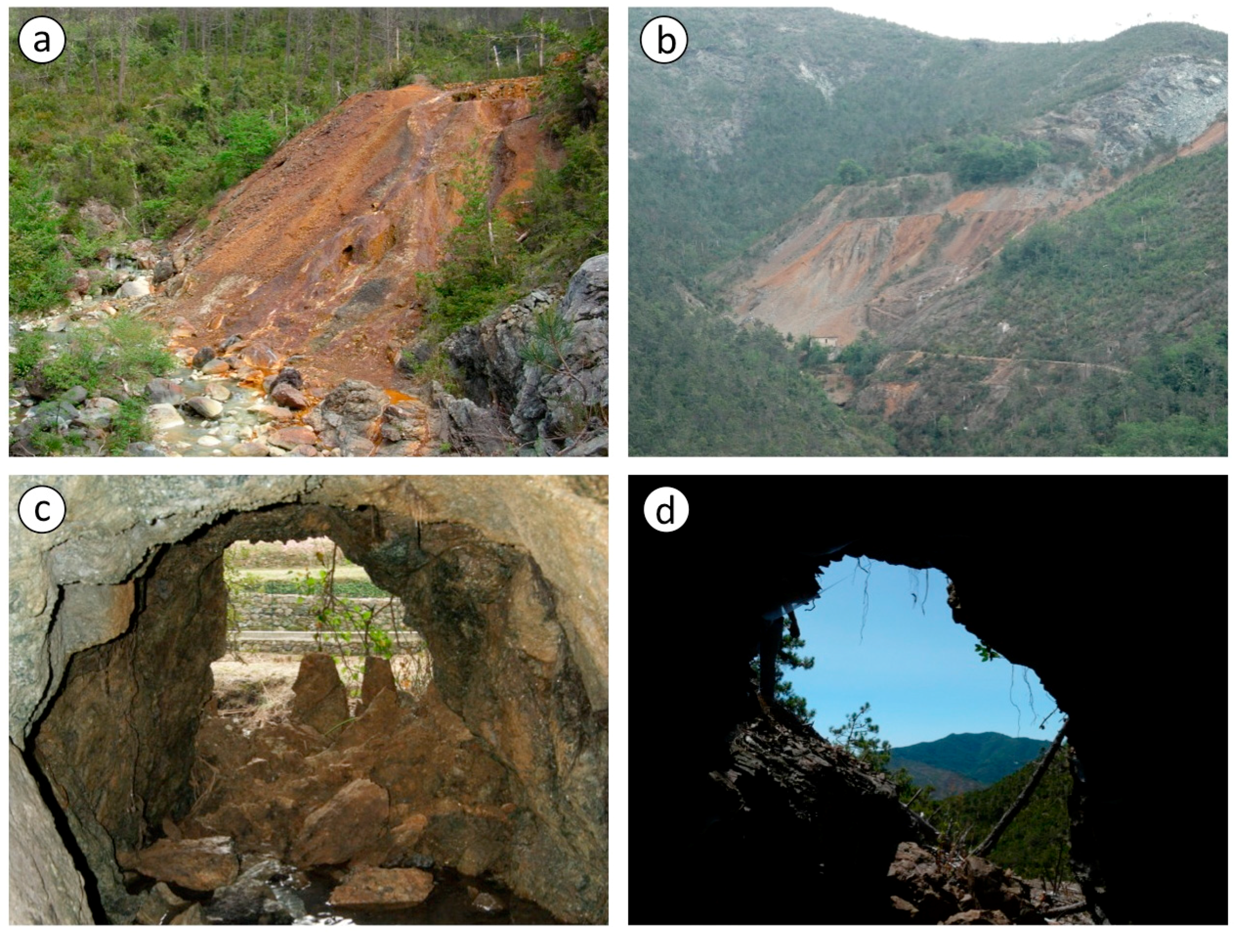
1.1. Environmental, Ecological, and Landscape Impact

Once the mining activities have stopped, a variety of environmental negative impacts arise. Typically, abandoned mines are characterized by tens to hundreds of kilometers of underground excavation, including mine galleries, stopes and chambers (arising from the removal of ore), vertical or near vertical shafts, and minor holes for ventilation and water drainage. Moreover, one or more open-cast pits can also be present. Non-mineralized rocks and non-valuable low-grade mineralizations are generally deposited within the mining area in open-air waste-rock dumps, which may contain high concentrations of ecotoxic metals. Moreover, the tailings deriving from beneficiation processes (including mechanical and chemical treatments) may be confined within natural or artificial impoundments. The main critical aspects arising from abandoned mines can be summarized as follows:
(i)
Collapse risk progressively increases in most underground galleries, voids, and chambers, thus creating potential ground deformations, subsidence, steep slope problems, and dangerous sinkholes on the surface [4]. In many cases, this critical situation may be even more dangerous since the condition of old abandoned mines is poorly documented or unknown and the documentation about the position of the underground workings, in relation to the surface features, is often lacking, incomplete, or inaccurate.
(ii)
Hydrogeological conditions are generally adversely affected by significant variations in surface and underground water circulation and by the raising of the piezometric level. These phenomena can damage the neighboring areas through drainage disruption and gradient alteration [4].
(iii)
Surface and underground water, circulating within the mine and in the mine waste, can be polluted, either by ecotoxic metals (released during the weathering of waste-rock dumps and tailings impoundments) or by chemicals used for beneficiation processes (e.g., mercury and cyanides). This scenario can be further exacerbated by the development of acid mine drainage (AMD) processes that are among the worst environmental threats affecting sulfide and coal mines [12,13,14]. Water pollution induced by mining activities is the most relevant problem because it may impact the territory and create direct hazards to humans well beyond the mine boundaries and for a long period of time.
(iv)
The soils of waste-rock dumps and, generally, those of the entire mining area, are usually characterized by severe physicochemical conditions (high ecotoxic metal contents, strong acidification, water-restricted conditions, and a paucity of nutrients) which affect soil-forming processes and the area's biodiversity by exerting a strong selective pressure on the biota [15].
(v)
The entire mining area, particularly open-air excavations and waste-rock dumps, are characterized by accelerated erosion processes, which may rapidly change the topography and induce several geological hazards, such as floods and landslides.
(vi)
Landscape can be strongly disturbed due to the high visual impact of mining activity remains, [4,5,16,17] such as: (a) decaying mining buildings and mineral processing plants; (b) widespread deforested up to desert areas; (c) unstable open-air excavations, spoil heaps, waste-rock dumps, and tailing impoundments; (d) open-pits, access roads, and other surface mine infrastructures.
(vii)
In addition to the environmental impact, the scarred landscape inherited from mining activities causes economic damage to public and private lands, thus representing a significant financial loss to owners and surrounding economies.

1.2. Positive Values Associated with Derelict Mines

Abandoned mines are complex engineering works that often represent a unique and specific branch of industrial archeology. Besides the structures, infrastructures, and industrial facilities connected with the exploitation and the beneficiation processes, abandoned mines often tell stories of local communities where mining was the central point of economic and/or social relationships.
The development of geoheritage tourism may offer mining districts important opportunities (e.g., [5,18,19]) and may contribute to the economic recovery of deprived areas. Below are reported some of the most important examples of the potential cultural and economic values associated with derelict mines.
(i)
Derelict mines often contain several tools, artifacts, structures, or machinery of historical or even archaeological value that are thus worthy of preservation. As highlighted by Ruiz Ballesteros and Hernández Ramírez, “the elements that could most appropriately be converted into a tourist resource through cultural tourism are the mining remains and the traces of mining culture” [18].
(ii)
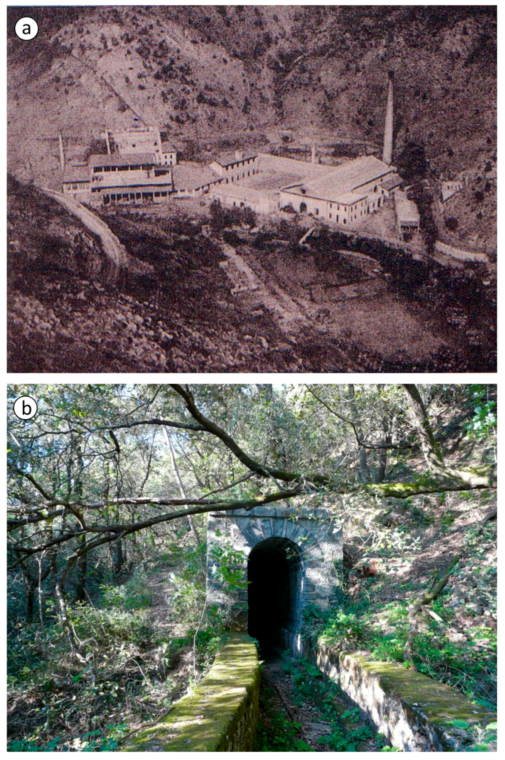
Some abandoned mines may have attractive features, as well as cultural, scientific, and engineering interest (such as open-cast pits, pitheads, mine adits, accessible mine galleries, and industrial facilities) and, if their state of preservation is good, they can be converted for didactic, scientific, recreational, and touristic activities [9,18]. As a matter of fact, several abandoned mines in the world have been turned into museums or other tourist attractions, or have been designated as “Sites of Special Scientific Interests”, “Regional Important Geological Sites”, or “Geoparks”. The cultural value of abandoned mines is acknowledged by UNESCO, which has included several former mining sites in the world heritage list [20,21] by the International Committee for the Conservation of the Industrial Heritage (TICCIH), by the European Landscape Convention, and by the Italian Code for Cultural Heritage and Landscape [22]. According to the Census of the Italian mining museums [23], in Italy 35 abandoned mines have been converted into tourist mines with over 200,000 visitors per year [24] and several others are in the course of evaluation for possible recovery. In eastern Liguria, the Gambatesa Mine (one of the most important European manganese mines in the last century) opened to the public in 2001 after its partial conversion into an underground exhibition of mining history and mineralogy. The museum comprises a visitor center with educational facilities, two underground routes, three external routes, and an interesting collection of mineral and rock samples. The museum quickly became a major tourist attraction with about 15,000 visitors per year, with a large influx of students from schools of all levels and grades as well as from universities. The mining museum closed in 2012 but, after several years of closure, it re-opened in December 2016.
(iii)
Waste-rock deposits may become potential resources and re-worked as extractive technology improves and/or the value of the metals increase. For example, the Roşia Montană Gold Corporation recently presented a mining claim project for the reworking of the waste-rock dumps of the Roşia Montană gold mine (Romania) with the goal of resuming fruitful and environmentally sustainable mining activities [25,26]. Among the planned initiatives, several programs and partnerships were designed for cultural heritage management.
(iv)
Stable underground mines can be converted for use as domestic or industrial waste storage, including slags, ashes from coal-fired power stations, and waste incinerators [4].
(v)
Underground mines often offer a particularly beneficial microclimate (constant humidity and temperature as well as absence of pollens and allergens) for people affected by respiratory problems like asthma. Speleotherapy is a special form of climatotherapy which uses underground environments (particularly caves and salt-mines) to treat several respiratory and skin-related diseases [27]. For example, the Mining Museum of Predoi (Bolzano, Italy) located at 1100 m a.s.l. (meters above sea level) set up a climate center within one of the galleries of the mine [28].
(vi)
Abandoned mines can be important sites for biodiversity heritage (both for flora and fauna) and for supporting rare and threatened species from many of the major taxonomic orders since they can host unique, rare, and ecologically important communities [29,30,31].

1.3. State of the Art and Aims

Due to economic reasons, most Italian mining activities closed in the 80s. Since their closure, no reclamation or restoration have been done in most of these sites due to a lack of specific laws or regulations. To this day, 2991 abandoned mining sites (684 open-pit sites, 2198 underground sites, and 109 mixed open-pit/underground mines) have been surveyed in Italy by the National Agency for Environmental Protection and Research (ISPRA) and the total number is presumably underestimated [23,24,32,33]. Any action aimed at the reclamation, restoration, or re-use of abandoned mine lands (AMLs) [3] requires a huge amount of information to assess their environmental and landscape impact, their stability and general state of conservation, as well as their geoheritage, scientific, didactic, cultural, historical, ecological, scenic, and touristic value.
In this article we present a pilot study focused on a sulfide mining district (Petronio and Gromolo valleys, Genova) located on the ophiolitic sequences of Northern Apennines (Eastern Liguria, Italy), with the aim of proposing a GIS-based model for the complete census of derelict mines and for the assessment of their geoheritage value, potential risks, and environmental impact. Finally, a case study for the implementation of an integrated tourist route is presented.

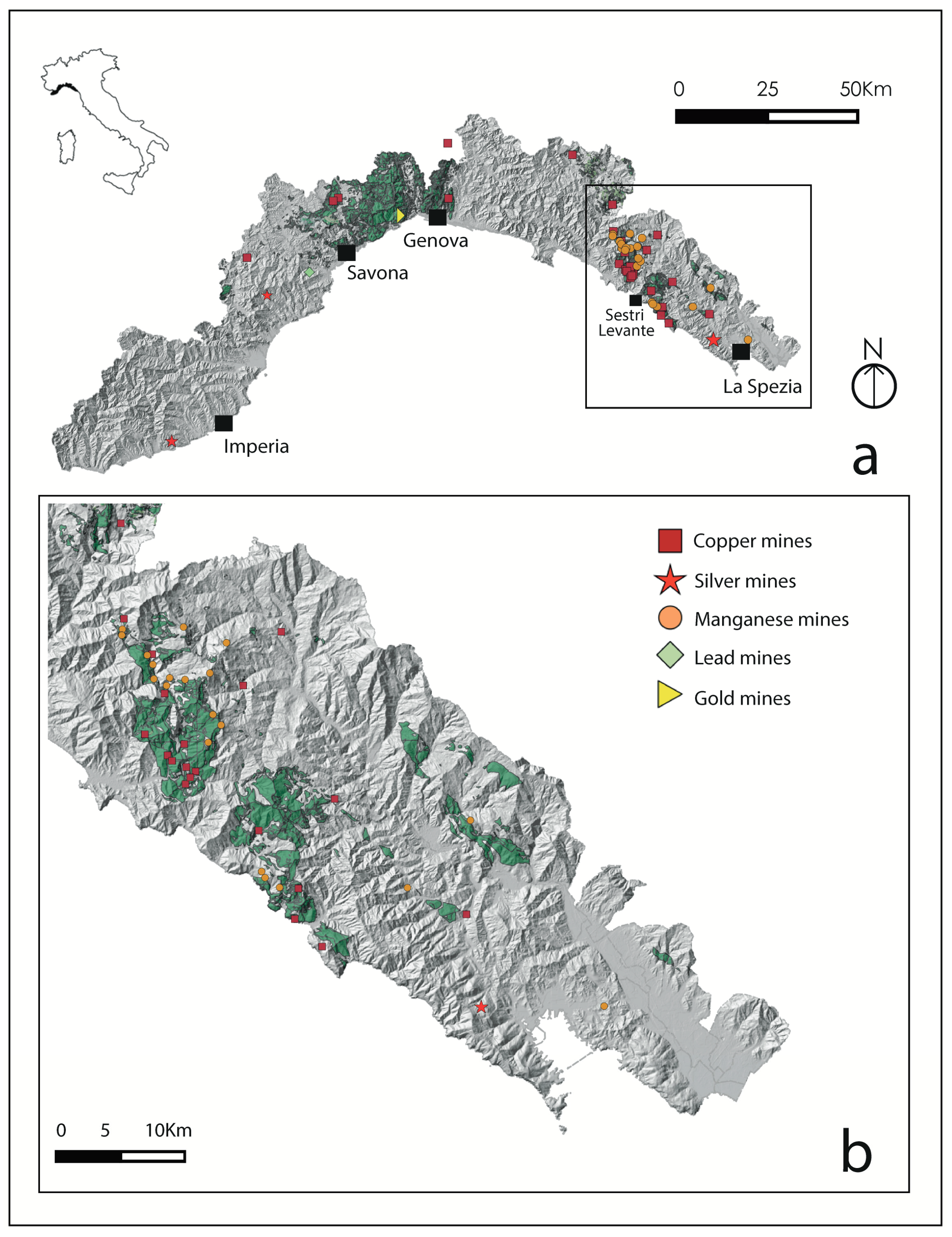
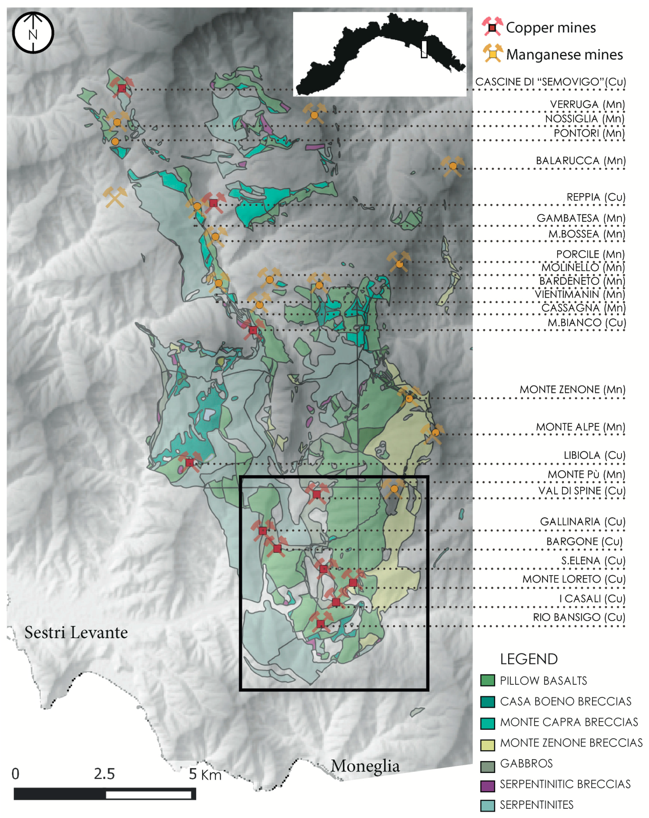
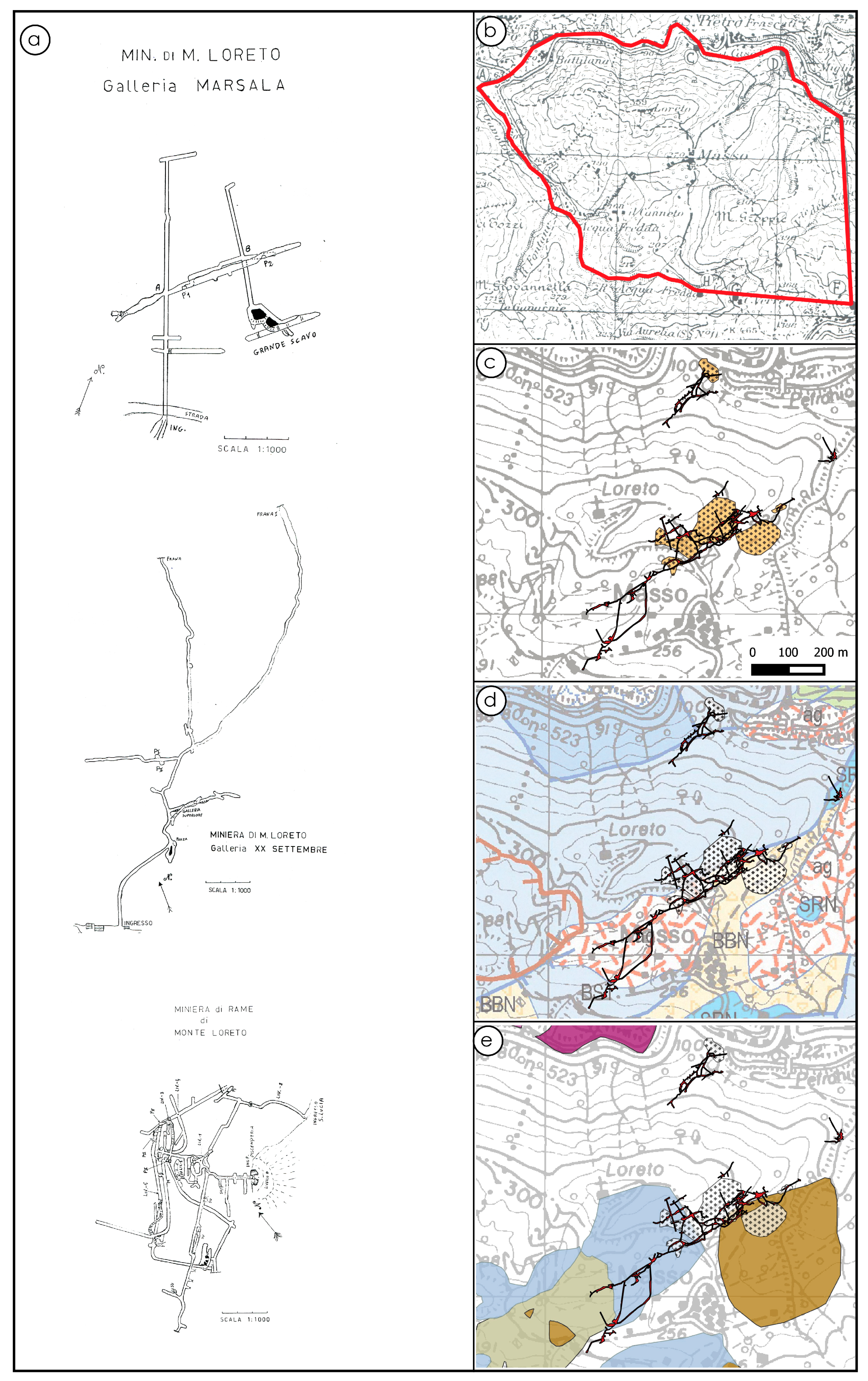
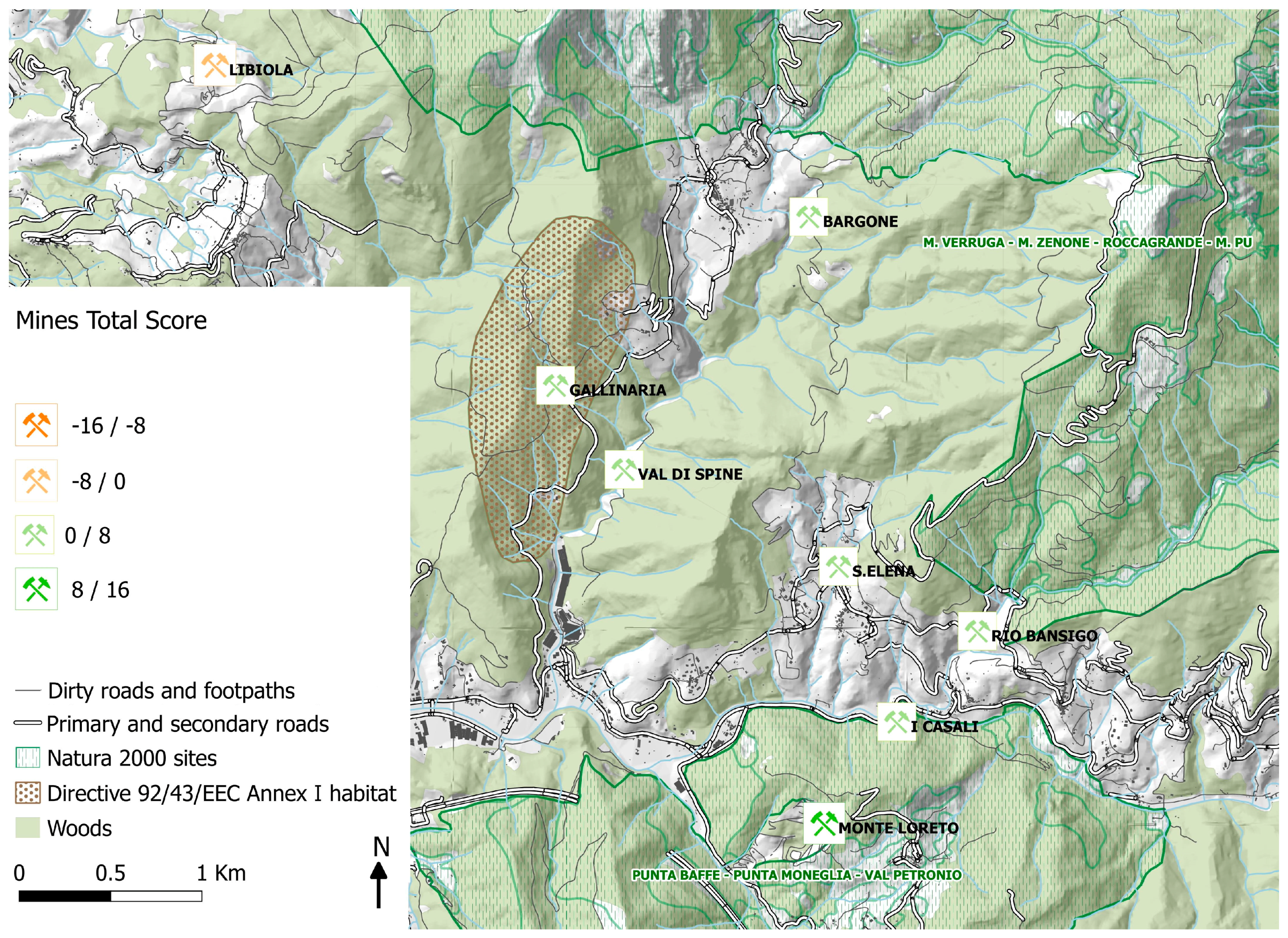
2. The Study Area: The Sulfide Mines of Petronio and Gromolo Valleys

Between the 19th and the first half of the 20th century, Liguria was one of the most important mining districts of Italy for the exploitation of Fe-Cu sulfides and manganese oxides (with a total of 38 mining sites according to the Census of Italian Mines; [34]). Figure 1a,b clearly highlight that the regional distribution of the mining sites is strictly related to the local geological context, since most of the mines are located within the ophiolites of eastern Liguria (i.e., Val di Vara Supergroup and Bracco Massif; Figure 1b); in particular, Fe-Cu mineralizations widely occur within basalts and, to a lower extent, in serpentinites, gabbros, and ophiolitic breccias [35,36,37], whereas Mn mineralizations occur within cherts capping the ophiolitic sequences [38,39,40].
The eastern Liguria Fe-Cu sulfide mineralizations represent a rare example of VMS (volcanic-associated massive sulfides)-type deposits associated either with the serpentinized peridotite basement and the overlaying MORB (mid-ocean ridge basalts)-type lavas. They are present in stockwork veins or in stratabound and stratiform ore bodies [37,41]. About 30 Fe-Cu sulfide mines are present in eastern Liguria, most of them located between the Graveglia and Petronio Valleys (Figure 2); it was estimated that they supplied (between 1850 and 1960) about 2–3 Mt of ore with an average grade of 2–7% Cu [37], thus representing one of the most important copper sources in Italy.
Of particular interest is the case of the Petronio and Gromolo Valleys, which comprise eight Fe-Cu sulfide mines in a very limited area (about 8 km2; Figure 2). The mining activity in this area started officially between 1849 and 1904, but several prehistoric handmade tools and charcoal found at the Monte Loreto and Libiola mines have been dated to around 3500 cal BC [43], thus documenting that copper extraction was already present in the Petronio Valley during the early Copper Age (Late Neolithic-Copper Age transition), making Monte Loreto and Libiola the earliest copper mine discovered in Western Europe so far [43,44,45]. Moreover, several evidences testify that copper extraction was also present in the Byzantine and early Medieval age [43]. The mining activity increased continuously from the end of the 19th century to the first decades of 20th century, developing into one of the most important industrial activities of the entire area. In 1884, a plant for the ore treatment and beneficiation (named originally “Molino del Bargonasco”; Figure 3a) was inaugurated at the lowermost part of the Bargonasco Valley, a right tributary of the Petronio creek [46,47].
This plant, at the beginning of the 20th century, also included a copper rolling mill for copper sheet production, which worked until 1990. Moreover, a 1300 m long water catchment channel, conveying the water of Bargonasco creek to the plant, was built for the production of electricity to operate the rolling mill machinery. The channel, consisting of nine arched bridges and three tunnels, was built entirely of local stones and is still in excellent condition, although partially overgrown with vegetation (Figure 3b).
Starting from 1920, the production of sulfide mines rapidly declined due to a deep crisis of the local mining sector and to the low metal prices in the international market that led to the definitive closing of most of the mines in 1927, with the exception of the Libiola mine whose closure dates back to 1962.

3. Methods

To understand the actual potentialities and criticalities of the Petronio and Gromolo mining districts as tourism destinations and, at the same time, to assess the feasibility of such a project, a GIS-based approach was applied. This choice is based on the potentiality of a Geographic Information System, which, besides managing and displaying different kinds of data, is able to support the elaboration of models and to develop scenarios related to possible recovery actions, acting as a decision-support tool. The Open Source software GRASS (Geographic Resources Analysis Support System) and QGIS (Quantum Geographic Information System) were used.
Several sources were consulted to gain all of the documentation needed and the gathered information was organized to provide a complete framework of the mining district.
The first stage led to a general and comprehensive description of the study area, taking into consideration its natural features (morphology, hydrography, vegetation, etc.) and human interventions (settlements, main and secondary roads, facilities, etc.). To implement this phase, official maps were used, supplied as Open Data by the Liguria Regional Government, in a scale from 1:50,000 to 1:5000, both vector (i.e., Regional Technical Cartography, land use maps, forests maps, administrative boundaries, routes, etc.) and raster (Digital Terrain Model, aerial and satellite imagery, geological and geomorphological maps, etc.).
More specific information was subsequently added, mostly about the former mining activity, and specifically:
(i)
Bibliography: scientific papers, old records, locally printed books, old guidebooks, etc.;
(ii)
Technical records: mining plans, old maps, law records, etc.;
(iii)
Old pictures, photographs, drawings, etc.;
(iv)
Interviews with ex-miners and local residents;
(v)
Field surveys, including in situ inspections, measurements, GPS (Global Positioning System) position data, sampling and analysis of the mining areas.
Actually, most of these data, originally had no spatial reference or provided only partial pieces of information (such as recent and historical photographs, documents, descriptions, and comments). Therefore, they were first geo-referenced by comparing them with present-day maps and finding out common landmarks to the land elements. Major efforts were put into the interpretation of the maps of mining areas and their adaptation within the GIS framework. In fact, such maps often have several drawbacks mainly due to their imprecise representation scale and to the scarce availability and reliability of geographical coordinates. Moreover, since the underground inspections of galleries and voids is generally dangerous and often hardly viable, a large part of the survey data concerning the underground development of the mines was partial and referred only to the mine adit or to the first few hundreds of meters of the mine galleries. In such a context, all the quantitative and qualitative data, referring to both the current state of the mining area and the past stages of mining activity, were employed to map the whole mine district (Figure 4).
All the data collected were integrated in the GIS environment and grouped into five main thematic sections. Section 1 contains geographical information such as coordinates, altitude, site dimensions, administrative boundaries, accessibility, and road networks. Section 2 contains the geological and ore deposit information, such as the mineralization types and the mineralogy and chemistry of ore and host-rocks. Section 3 contains information about the mining structures and infrastructures and their spatial arrangement, i.e., mine working types (underground and/or surface mining), mine adits (location, accessibility, state of conservation, stability), waste-rock and tailing deposits (location, dimension, height, slope, surface area, estimated volume), and finally mining buildings and plants. Section 4 contains data and information about the environmental problems and potential risks comprising data on the contamination of soils and waters, landslides, subsidence, collapses, and other ground failures. Finally, Section 5 is devoted to the potential values of the mining sites including archeological sites, historical buildings, cultural assets, as well as scientific and landscape values.
On the basis of the information collected for every section, a conceptual flowchart was defined (Figure 5), considering two main tracks for the evaluation of critical issues (CI) and positive values (PV).
Qualitative and quantitative data were integrated and different scores were assigned to each field of the flowchart based on the criteria reported in Table 1 and Table 2 and described in the text. Reclassification and map algebra operations were performed in order to obtain partial and total scores for a quick preliminary evaluation of each mining site. The total score (TS; Table 3) consists of the summary assessment of partial scores of CI and PV according to the formula:
TS = (Gv + Lv + Hv + Av + Tv) + (Sc + Wc + Ad + Vi + Hi).
CI-1 (Sc). Soil contamination depends on the presence of potentially toxic elements (PTEs) in the exploited ore and/or in the wall-rocks as well as on the use of contaminants in the beneficiation processes [3,46]. In particular, short- and long-term soil pollution by toxic metals is strictly related to six types of mine exploitation i.e., energy minerals, precious metals, non-ferrous metals, ferrous metals, and industrial minerals [48]. In the event that one or more of these conditions are satisfied, the intensity of the contamination is directly correlated with the extent of the mining activity in the area (e.g., underground and open-pit excavations, waste-rock dumps and tailings disposals, plants for in situ processing of the extracted ore, areas for the temporary storage of the extracted material, etc.).
CI-2 (Wc). Water contamination depends on the reactivity of minerals of the exploited ore and/or wall-rocks as well as on the use of contaminants in the beneficiation processes. In the event that one or more of these conditions are satisfied, the intensity of the contamination is directly correlated with the extent of the mining activity in the area and with the geometry of the watershed with respect to the mining area.
CI-3 (Ad). Acid mine drainage depends on the presence and relative abundance of sulfides (mainly pyrite and pyrrhotite) in the exploited ore and/or wall-rocks. Pyrite and pyrrhotite are generally non-economic minerals in polymetallic sulfide ores and are therefore commonly discarded and deposited in waste-rock dumps.
The capacity of rocks and sediments to generate AMD can be calculated following the AMIRA (Australian Mineral Industries Research Association) procedure [49]. If AMD is possible and persists over time, its intensity is directly correlated with the extent of the mining activity in the area and with the geometry of the watershed with respect to the acid producing sites.
CI-4 (Vi). The visual impact of mining sites was evaluated considering the presence and the visibility of degraded elements and areas (visual “misfits” in the landscape) which induce a contrast of shapes, textures, and colors [5]. These are particularly represented by mining activity remains with very low aesthetic quality or in an evident state of decay (e.g., decaying mining buildings, mineral processing plants, etc.) and changes in landscape and morphology (e.g., deforested areas, open-air excavations and waste-rock dumps, spoil heaps, etc.). The class and the relative score were assigned considering both the extent of the visual impact inside the site and the extent of the impact on the surrounding landscape assessed outside the mining area. Other anthropic elements were also considered, even if not directly related to mining activities (e.g., highways, quarries, industrial plants, solid waste and illegal dumps, etc.).
CI-5 (Hi). Hydrogeomorphological impact within a mining area is mainly due to the strong surface modification of the former topography [4,50] and to the realization of underground excavations. These modifications can affect the surface and underground water circulation and create potential ground deformations, subsidence, and steep slope problems, thus inducing several geological hazards, such as floods and landslides. The class and the relative score, evaluated by geomorphological photointerpretation, the evaluation of mining plans, and field investigations, were assigned considering the extent of modification induced by mining activities and by verifying the presence of critical issues within the mining sites and in the surrounding areas.
The criteria used to assess the different positive values of the AMLs were based on the individuation of specific elements with cultural, scientific, and educative importance and on the evaluation of their rareness, representativeness, and integrity [51,52].
PV-1 (Gv). Geological values were determined by the presence of peculiar geoheritage elements (such as rock units, faults, folds, minerals, ores and metallogenic features, geomorphological landform, etc.) and by their diffusion and accessibility within the mine and surrounding areas.
PV-2 (Lv). “Landscape means an area, as perceived by people, whose character is the result of the action and interaction of natural and/or human factors” (European Landscape Convention CETS No 176, 20/10/2000; entered into force: 1/3/2004). Landscape value, thus, is not easily defined and strongly depends on peoples' scenic preferences. In this context, landscape and ecological value was evaluated considering both the presence of habitat, flora, and fauna of recognized importance (e.g., Natura 2000 sites and protected areas; Council Directive 92/43/EEC on the conservation of natural habitats and of wild fauna and flora—Habitats Directive) and the scenic quality of the mining areas (e.g., aesthetically valuable and/or evocative elements with clear relation to mining activities) and of the surroundings (e.g., panorama, natural landscapes, historic settings, etc.).
PV-3 (Hv). In the past more than today, mining activity used to involve not only the people directly working in the mining sites, but in an indirect way, their families, the villages where they lived, and sometimes even the whole district. Therefore, historical evidences of this activity can be found not only in the immediate neighborhood of the mining sites, but also spread in a wider area. They may also refer to different periods and in such a way can contribute to our understanding of the evolution both of the mining activity and the surrounding areas. They can be marks on the territory, such as service buildings for the miners which witness their everyday life around the mine (i.e., dormitories, kitchens, etc.), transformation plants, waste-rock dumps, roads and paths used to reach the working places or to carry the ore away, water canals and ditches, or entire villages built at first to lodge the miners’ families or other mine-related workers, which eventually developed into autonomous settlements. Also, less noticeable elements can tell a lot about the mining history of a place, for example disused mining tools adapted to agriculture and other craft activities, waste-rocks used as building materials, historical technical documents, memorials, paintings, and other artworks by contemporaries of the mining activity. Non-material historical heritage (such as tales, recipes, songs, nicknames, etc.) is also important to give a more complete framework of a mining district. In this context, the more all of these different kinds of historical elements are well maintained and readable in the studied area, the higher is the score assigned for the historical value (Table 2).
PV-4 (Av). The International Charter for Archaeological Heritage Management (ICOMOS 1990) defines archaeological heritage as that part of the material heritage in respect of which archaeological methods provide primary information [53]. Archeological value was determined by the presence of valuable items (archeological mining artifacts, slag heaps, excavations, abandoned structures, etc.) and the possibility of making them accessible without risk for their conservation.
PV-5 (Tv). The touristic value of a mine cannot be considered separately from that of its geographical context. In fact, besides its intrinsic value, a derelict mining area becomes an asset for its surrounding district as long as its tourism-oriented exploitation is integrated in a structured tourist offer. In such a view, tourist services should be considered (i.e., public transport, accommodation, guided tours, etc.), as well as the presence nearby of other natural, cultural, and recreational resorts. A visit to a former mining complex may be worth a day trip, but if it is possible to combine it with other activities, the whole district is expected to be more and more attractive. At the same time, the variety of a mining area and its neighborhoods and therefore its capability to appeal to different kinds of visitors—from schools to geologists—is also an asset. The area accessibility is a relevant aspect for its touristic valorization. Mine entrances are not necessarily close to motorable roads and, in many cases, some walks allow visitors to appreciate the natural and historical context. Still, a mining site or a group of sites that are reachable from a village or a well-known place without car transfers or boring walks along major roads or brownfields is certainly more appealing. In this regard, well-maintained and varied hiking paths, both to link mining sites and to discover the district landscape, are important elements to take into consideration.

4. Results

The flowchart for the evaluation of critical issues and positive values of abandoned mining areas (Figure 5) was applied to the eight sulfide mines of the Petronio and Gromolo Valleys (Libiola, M. Loreto, Rio Bansigo, Gallinaria, Bargone, Val di Spine, S. Elena, and Casali; depicted within the black square in Figure 2) and the relative scores for CI and PV were assigned (Table 3) on the basis of the criteria described in the previous section (Table 1 and Table 2). Visual representation of the selected mining sites with the relative total scores is reported in Figure 6.
After their closure, all of the mining sites considered in this work remained completely abandoned until the present day, and they thus present several unsettled environmental issues and geological hazards.
The worst scenario is represented by the largest and most important mine of the area (Libiola mine), which is characterized by active and diffuse acid mine drainage processes (Figure 6a), leading to severely contaminated water and soils [54,55,56,57,58]. Moreover, the entire mining area is characterized by the presence of huge open-air waste-rock dumps (covering a total surface area of about 50,000 m2) and open-pit excavations [54,55] with evidences of accelerated erosion processes and local landslides (Figure 7a,b). These waste-rock dumps were built on mountainsides, close or adjacent to streams and creeks, thus representing additional sources for acid mine drainage and metal contaminated solution in the watershed's rivers and streams (Figure 7a). Finally, the presence of open-air excavations, waste-rock dumps, deforested areas, and decaying mining buildings and plants have a negative visual impact both within the mining site and in the surrounding landscape.
The negative partial score for the critical issues of Libiola mine (Table 3) evidenced that the reclamation and rehabilitation for touristic and cultural purposes of this mine is hardly achievable, technically unfeasible, and economically unsustainable. In fact, despite the generally high positive values (Table 3) the entire mining area would require extensive reclamation works, including contaminant cleanup from environmental media, major hydraulic works for the control and treatment of mine water (surface runoff, groundwater seepage, surface water inflow, mine water discharges), and the stabilization and securing of landslides, land subsidence, waste-rock dumps, and underground voids.
Conversely, the other seven mines obtained positive total scores (Table 3) although they present several, but limited, critical issues. In these mines, soil contamination is localized in few specific sites mainly represented by small- or medium-sized waste-rock dumps (100–5000 m2) or small areas adjacent to mine adits. Similarly, water contamination and acid mine drainage processes are restricted to a few specific sites and do not significantly affect the natural drainage of the watershed.
These mines are characterized by the exclusive presence of underground excavations and hydrogeomorphological issues are not present or very limited. Several easily accessible mine adits are common in all seven mines (Figure 6c,d); although they currently represent potential risks to the safety of people, some of them could be evaluated for possible recovery and turned into underground routes and/or underground exhibitions. Finally, the visual impact of these mines is low and is mainly restricted to specific sites within the mining areas.
Although highly variable, all of these seven mines obtained a positive total score (3 through 13; Table 3) due both to the limited critical issues and to the presence of geoheritage elements and other positive values. Despite this variability, the added value bringing together these mines is represented by their proximity, since they occur within an area of about 8 km2 between the Petronio and Bargonasco Valleys (Figure 2 and Figure 7a). For this reason, we designed an integrated cultural and touristic route that combines several points of interest (POIs) selected for their geological, landscape, ecological, historical, archeological, and touristic values.

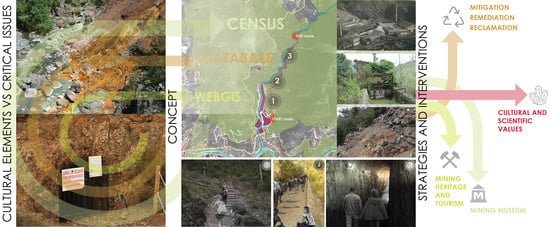
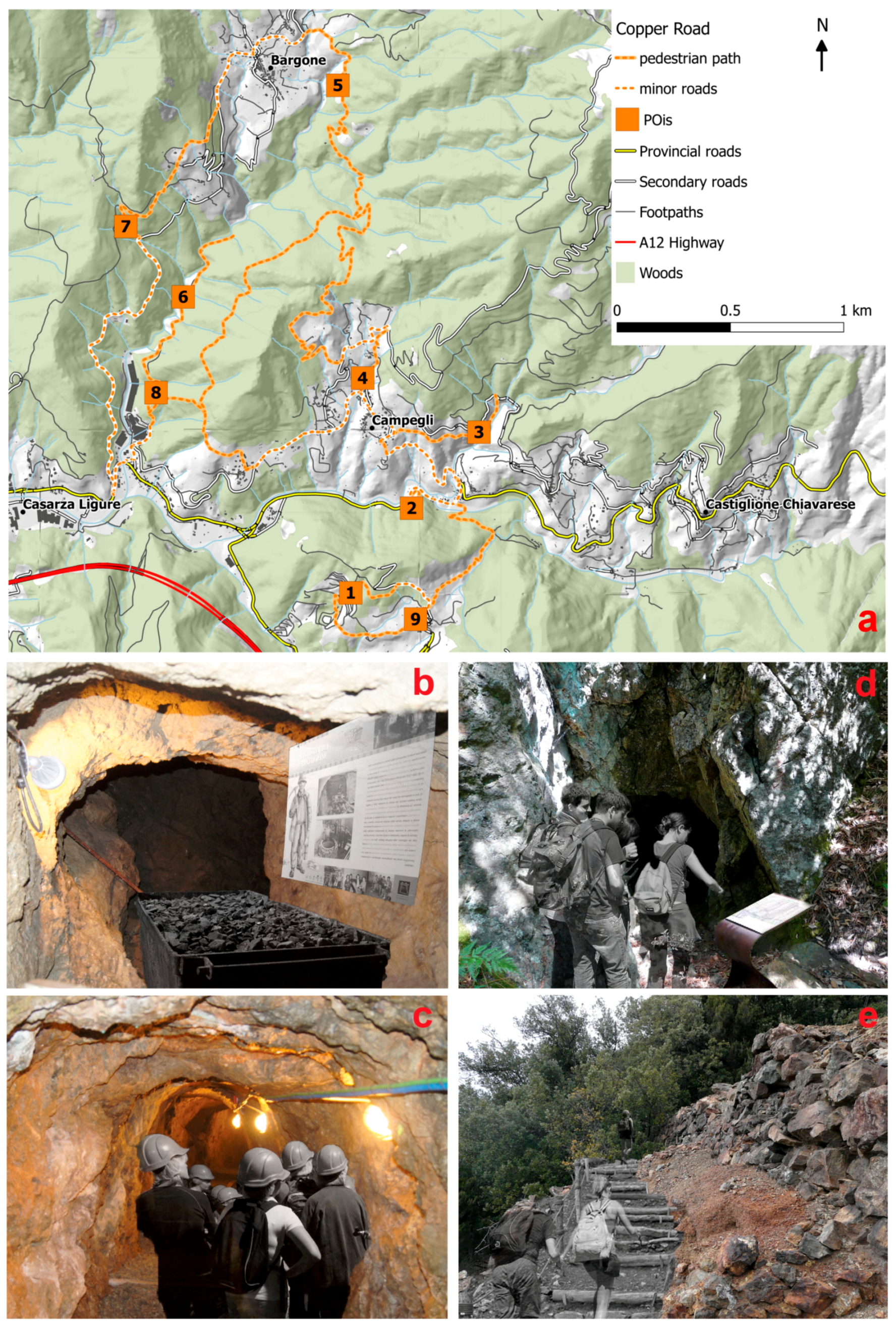
The Ligurian “Copper Road”, an Integrated Tourist Route

The proposed route (with a total length of 23.2 km, of which 14.5 stretches along footpaths) has been called the “Copper Road” because it is suitable for the valorization of the copper mining legacy, since most of the past activity related to the complete copper cycle (prospection, extraction, beneficiation, transformation, and transport) are involved and easily observable or reconstructable. In addition, there are a number of valuable geological, historical, archaeological, cultural, and landscape features along the route. Moreover, this area is located a few tens of kilometers from important Ligurian touristic sites and seaside resorts with several localities known worldwide (such as Cinque Terre and Portofino) and important touristic attractions, such as the Aquarium of Genova (the largest aquarium in Italy) and the “Strade Nuove and the system of the Palazzi dei Rolli” in Genova’s historic center (which is a UNESCO World Heritage Site). This peculiarity represents an important added value for the valorization of rural areas and might be used by public and private organizations to create synergy to trigger and consolidate geoheritage tourism. It has indeed been shown that industrial heritage tourism is most successful where regenerated areas or museums are located near to other touristic attractions [19,59].
The “Copper Road” can be quickly reached starting from the town of Casarza Ligure (Figure 8) and comprises several thematic routes developed either on provincial and secondary roads or on pedestrian paths and cycle tracks. Most of the paths have been developed over former mining-related routes (e.g., water canals, access routes, railway lines). Eight main POIs were selected (Figure 8a) and several secondary POIs were chosen along the thematic routes for their natural, landscape, and rural significance or as services for tourists (e.g., restaurants, hotels, touristic attractions). Both thematic routes and POIs have already been inserted in the GIS maps and database.

5. Discussion and Conclusions

The processes of post-mining restoration, reclamation, rehabilitation, or revitalization [60,61,62] require a large amount of crucial information that needs to be collected, classified, and organized to evaluate all options of land re-use [60] and, afterward, to prepare lands for development and to estimate the sustainability of their re-use [63].
The procedure proposed in this study is intended as a preliminary assessment of those negative impacts and positive values associated with the presence of abandoned mining sites which can allow the characterization of the current state of the sites and their surrounding areas. Several works in the literature address the assessment of the tourist potential of geosites, geodiversity, or geoheritage elements [8,52,64,65,66,67]. Nevertheless, most of them are hardly applicable to abandoned mining sites since their positive potentialities are often combined with relevant environmental criticalities. For these reasons, we think that this preliminary appraisal is an important (necessary) stage for the evaluation of the potentiality of mining sites as a possible local development driving force, which will determine if further and deeper evaluation is needed. As a matter of the fact, a recent review on abandoned mining lands all over the world [3] evidenced that no consolidated information on their global occurrence or on their state of conservation exists.
The assessment procedure proposed in this work was applied to a pilot mining area in eastern Liguria (Italy) and led to the drafting of a possible integrated cultural and touristic route that combines several valuable industrial, geological, historic, archaeological, and landscape features. This route, the so-called “Copper Road”, is located in a regional context with high touristic potential and joins several genetically related ore deposits (metallogenic clusters), which can also represent sites for scientific research and educational projects, engaging researchers of different disciplines and students of various levels from beginning to advanced [10].
Similar examples of thematic routes and itineraries connected with geological heritage and geotourism have been reported for several localities in Europe and in Italy (e.g., [68,69,70,71,72]). Some of these specifically have mining heritage as their main theme (e.g., [6,9,10]). One example of success of a mining heritage route is the “GeoRoute Ruhr” in the Ruhr Area National Geopark (Germany) which represents a 180-km network of geotrails linking mining heritage, geosites, and other cultural sights [9]. The route contributed to the development of tourist infrastructure in the area and is used for excursions and trips as well as for a great number of field trips for environmental education at different levels [9].
To evaluate whether the proposed route can waken interest and become an effective touristic attraction, further developments of this project could include a detailed analysis of the attractiveness of the chosen area both by means of survey methods and by the assessment method of geotouristic objects proposed by Štrba and Rybár [73]. For the survey, all of the sites and the whole route will be subjected to specific research based on semantic differential or other methods, as recently described by Baczyńska et al. for the evaluation of the attractiveness of abandoned quarries [8]. The sample group for the survey, belonging to different age groups, will include all possible users (such as local and foreign tourists, ecotourists, teachers, students, trekkers, hikers, cyclists, restaurateurs, and hoteliers) in addition to the inhabitants of the surrounding areas and the members of the local and regional councils.
The proposed procedure can be applied on a local, regional, and even national scale and aims to include abandoned mine lands in a GIS environment and to produce a GIS-based database, which is the first step in the development of site-specific detailed assessments and the realization of recovery work plans.
An essential advantage of using a GIS-based approach for this multicriteria evaluation process is the possibility of dynamically improving the results, both including new data and considering different management needs [74]. For example, a possible development could be the restitution of data acquired by sensors in hazardous or poorly accessible areas and their elaboration in relation to other parameters mapped for a continuous and reasoned monitoring of these areas.
Data stored in the GIS environment could also contain all the critical information that should be considered in an advanced step for any possible reclamation project, supporting the estimation of the potential costs and the actual economic sustainability.
In the future, the implementation of direct access to the collected data through a WebGIS, with the creation of different levels of users based on their specific needs (mainly technical, management, and end-users), is being considered for further development. This could represent a useful tool both for supporting decision-making and for educational and tourism purposes. Considering this second aim, thanks to the great amount of historical data and maps collected, multimedia content could be integrated in order to describe the role and evolution of mining districts.
A dedicated mobile responsive website (e.g., [68]) and a user-friendly GPS-based application could also be developed in order to allow visitors to obtain more detailed and target-oriented on-site contents along the route, as well as to plan and enjoy a more comprehensive experience of the area.

Author Contributions

P.M., G.B., and G.S. conceived of the presented idea; G.S., M.S., V.M., and P.S. analyzed and elaborated the data for the GIS-based database; C.M. contributed to the historical research and field survey; P.M. and G.S. wrote the paper and made the figures. All authors discussed the results and contributed to the final manuscript.

Acknowledgments

We are grateful to Angelo Perrone for providing historical and photographic material from his private collection. The authors wish to thank the reviewers for their insightful and constructive remarks.

Conflicts of Interest

The authors declare no conflict of interest.

References

  1. Gutiérrez, M.; Mickus, K.; Camacho, L.M. Abandoned Pb Zn mining wastes and their mobility as proxy to toxicity: A review. Sci. Total Environ. 2016, 565, 392–400. [Google Scholar] [CrossRef] [PubMed]
  2. Kim, S.M.; Suh, J.; Oh, S.; Son, J.; Hyun, C.U.; Park, H.D.; Shin, S.H.; Choi, Y. Assessing and prioritizing environmental hazards associated with abandoned mines in Gangwon-do, South Korea: The total mine hazards index. Environ. Earth Sci. 2016, 75, 1–14. [Google Scholar] [CrossRef]
  3. Venkateswarlu, K.; Nirola, R.; Kuppusamy, S.; Thavamani, P.; Naidu, R.; Megharaj, M. Abandoned metalliferous mines: Ecological impacts and potential approaches for reclamation. Rev. Environ. Sci. Biotechnol. 2016, 15, 327–354. [Google Scholar] [CrossRef]
  4. Bell, F.G.; Donnelly, L.J. Mining and Its Impact on the Environment; Taylor & Francis: Abingdon, UK, 2006; p. 547. [Google Scholar]
  5. Favas, P.J.C.; Martino, L.E.; Prasad, M.N.V. Abandoned mine land reclamation—Challenges and opportunities (holistic approach). In BioGeotechnologies for Mine Site Rehabilitation; Prasad, M.N.V., Favas, P.J.C., Maiti, S.K., Eds.; Elsevier Inc.: Amsterdam, The Netherlands, 2018; pp. 3–31. ISBN 9780128129869. [Google Scholar]
  6. Horváth, G.; Csüllög, G. The role of ecotourism and geoheritage in the spatial development of former mining regions. In Post-Mining Regions in Central Europe—Problems, Potentials, Possibilities; Wirth, P., Černič Mali, B., Fischer, W., Eds.; Oekom Verlag: Munchen, Germany, 2012; pp. 226–240. ISBN 978-3-86581-294-0. [Google Scholar]
  7. Černič Mali, B.; Fischer, W. Post-Mining Regions in Central Europe—Problems, Potentials, Possibilities; Oekom Verlag: Munchen, Germany, 2012; p. 269. ISBN 978-3-86581-294-0. [Google Scholar]
  8. Baczyńska, E.; Lorenc, M.W.; Kaźmierczak, U. The landscape attractiveness of abandoned quarries. Geoheritage 2017, 1–15. [Google Scholar] [CrossRef]
  9. Wrede, V.; Mügge-Bartolović, V. GeoRoute Ruhr—A network of geotrails in the Ruhr Area National GeoPark, Germany. Geoheritage 2012, 4, 109–114. [Google Scholar] [CrossRef]
  10. López-García, J.A.; Oyarzun, R.; López Andrés, S.; Manteca Martínez, J.I. Scientific, educational, and environmental considerations regarding mine sites and geoheritage: A perspective from SE Spain. Geoheritage 2011, 3, 267–275. [Google Scholar] [CrossRef] [Green Version]
  11. Wimbledon, W.A.P. Geosites—A new conservation initiative. Episodes 1996, 19, 87–88. [Google Scholar]
  12. Jambor, J.L.; Blowes, D.W. The Environmental Geochemistry of Sulfide Mine-Wastes; Short-Course Handbook; Mineralogical Association of Canada: Waterloo, ON, Canada, 1994; Volume 22, p. 438. [Google Scholar]
  13. Anawar, H.M. Sustainable rehabilitation of mining waste and acid mine drainage using geochemistry, mine type, mineralogy, texture, ore extraction and climate knowledge. J. Environ. Manag. 2015, 158, 111–121. [Google Scholar] [CrossRef] [PubMed]
  14. Macías, F.; Pérez-López, R.; Caraballo, M.A.; Sarmiento, A.M.; Cánovas, C.R.; Nieto, J.M.; Olías, M.; Ayora, C. A geochemical approach to the restoration plans for the Odiel River basin (SW Spain), a watershed deeply polluted by acid mine drainage. Environ. Sci. Pollut. Res. 2017, 24, 4506–4516. [Google Scholar] [CrossRef] [PubMed]
  15. Roccotiello, E.; Marescotti, P.; Di Piazza, S.; Cecchi, G.; Mariotti, M.G.; Zotti, M. Biodiversity in Metal-Contaminated Sites—Problem and Perspective—A Case Study. In Biodiversity in Ecosystems—Linking Structure and Function; Lo, Y.-H., Blanco, J.A., Roy, S., Eds.; InTech: Rijeka, Croatia, 2015; pp. 563–582. ISBN 978-953-51-2028-5. [Google Scholar]
  16. Dentoni, V.; Massacci, G. Assessment of visual impact induced by surface mining with reference to a case study located in Sardinia (Italy). Environ. Earth Sci. 2013, 68, 1485–1493. [Google Scholar] [CrossRef]
  17. Menegaki, M.; Koutiva, I.; Kaliampakos, D. Assessing the chromatic contrast in open surface excavations: A comparative study between subjective and quantitative approaches. Int. J. Min. Reclam. Environ. 2015, 29, 112–124. [Google Scholar] [CrossRef]
  18. Ruiz Ballestreros, E.; Hernández Ramirez, M. Identity and community—Reflections on the development of mining heritage tourism in Southern Spain. Tour. Manag. 2007, 28, 677–687. [Google Scholar] [CrossRef]
  19. Cole, S. Exploring the Sustainability of Mining Heritage Tourism. J. Sustain. Tour. 2004, 12, 480–494. [Google Scholar] [CrossRef]
  20. UNESCO 2005 World Heritage List. Available online: http://whc.unesco.org/en/list/ (accessed on 25 May 2018).
  21. Conesa, H.M.; Schulin, R.; Nowack, B. Mining landscape: A cultural tourist opportunity or an environmental problem? Ecol. Econ. 2008, 64, 690–700. [Google Scholar] [CrossRef]
  22. Italian Legislative Decree No. 42 of 22 January 2004. Code of Cultural Heritage and Landscape, in Accordance with Article 10 of the Law No. 137 of July 6, 2002; Ministero per i beni e le attività culturali: Roma, Italy, 2004.
  23. Patané, A. Recupero e valorizzazione delle miniere dismesse: Lo stato dell’arte in Italia. In Proceedings of the Geoitalia 2009—VII Forum Italiano di Scienze Della Terra, Rimini, Italy, 9–11 September 2009; Quaderni—Ambiente e Società n. 3, ISPRA—Istituto Superiore per la Protezione e la Ricerca Ambientale: Roma, Italy, 2011; p. 178, ISBN 978-88-448-0478-7. [Google Scholar]
  24. Garofano, M.; Govoni, D. Underground Geotourism: An historic and economic overview of show caves and show mines in Italy. Geoheritage 2012, 4, 79–92. [Google Scholar] [CrossRef]
  25. RMGC. Report on Environmetal Impact Assessment study. Technical Document. 2006. Available online: http://en.rmgc.ro/rosia-montana-project/environment.html (accessed on 25 May 2018).
  26. Servida, D.; Comero, S.; Dal Santo, M.; De Capitani, L.; Grieco, G.; Marescotti, P.; Porro, S.; Lázár Forray, F.; Gál, Á.; Szakács, A. Waste rock dump investigation at Roşia Montană gold mine (Romania): A geostatistical approach. Environ. Earth Sci. 2013, 70, 13–31. [Google Scholar] [CrossRef]
  27. Lăzărescu, H.; Simionca, I.; Hoteteu, M.; Mirescu, L. Speleotherapy—Modern bio-medical perspectives. J. Med. Life 2014, 7, 76–79. [Google Scholar] [PubMed]
  28. Val-pusteria.net. Available online: https://www.val-pusteria.net/it/cultura-e-territorio/musei-e-mostre/ (accessed on 25 May 2018).
  29. Batty, L.C. The potential importance of mine sites for biodiversity. Mine Water Environ. 2005, 24, 101–103. [Google Scholar] [CrossRef]
  30. Beneš, J.; Kepka, P.; Konvička, M. Limestone quarries as refuges for European xerophilous butterflies. Conserv. Biol. 2003, 17, 1058–1069. [Google Scholar] [CrossRef]
  31. Germano, D.; Machado, R.; Godinho, S.; Santos, P. The impact of abandoned/disused marble quarries on avifauna in the anticline of Estremoz, Portugal: Does quarrying add to landscape biodiversity? Landsc. Res. 2016, 41, 880–891. [Google Scholar] [CrossRef]
  32. Ballestrazzi, P.; Berry, P.; Fabbri, S. Il censimento del patrimonio minerario nazionale ai fini del recupero ambientale delle aree dismesse. In Proceedings of the Meeting “Riabilitazione delle Aree Minerarie”, Abbadia S. Salvatore, Italy, 15 November 1991; A.N.I.M. (Associazione Nazionale Ingegneri Minerari), Edizioni PEI: Parma, Italy, 1991; pp. 11–20. [Google Scholar]
  33. Berry, P.; Bandini, A.; Dacquino, C. Classificazione dei siti minerari sotterranei abbandonati mediante un indice di rischio statico-strutturale. In Proceedings of the Geoitalia 2009—VII Forum Italiano di Scienze Della Terra, Rimini, Italy, 9–11 September 2009; Quaderni—Ambiente e Società n. 3, ISPRA—Istituto Superiore per la Protezione e la Ricerca Ambientale: Roma, Italy, 2011; pp. 31–43, ISBN 978-88-448-0478-7. [Google Scholar]
  34. A.P.A.T. Censimento Dei Siti Minerari Abbandonati. I Siti Minerari Italiani (1870–2006); Ministero dell’Ambiente e Della Tutela del Territorio—Agenzia per la Protezione dell’Ambiente e per i Servizi Tecnici (A.P.A.T): Roma, Italy, 2006; p. 95.
  35. Ferrario, A.; Garuti, G. Copper deposits in the basal breccias and volcano-sedimentary sequences of the eastern ligurian ophiolites (Italy). Miner. Depos. 1980, 15, 291–303. [Google Scholar] [CrossRef]
  36. Garuti, G.; Zaccarini, F. Minerals of Au, Ag, and U in volcanic-rock-associated massive sulfide deposits of the Northern Apennine ophiolite, Italy. Can. Mineral. 2005, 43, 935–950. [Google Scholar] [CrossRef]
  37. Garuti, G.; Bartoli, O.; Sacchetti, M.; Zaccarini, F. Geological setting and structural styles of Volcanic Massive Sulfide deposits in the northern Apennines (Italy): Evidence for seafloor and sub-seafloor hydrothermal activity in unconventional ophiolites of the Mesozoic Tethys. Boletin Soc. Geol. Mex. 2008, 60, 121–145. [Google Scholar] [CrossRef]
  38. Marescotti, P.; Cabella, R. Significance of chemical variations in a chert sequence of the “Diaspri di Monte Alpe Formation” (Val Graveglia, Northern Apennine, Italy). Ofioliti 1996, 21, 139–144. [Google Scholar]
  39. Cabella, R.; Lucchetti, G.; Marescotti, P. Mn-ores from Eastern Ligurian ophiolitic sequences (“Diaspri di Monte Alpe” Formation, Northern Apennines, Italy). Trends Mineral. 1998, 2, 1–17. [Google Scholar]
  40. Marescotti, P.; Frezzotti, M.L. Alteration of braunite ores from Eastern Liguria (Italy) during syntectonic veining processes: Mineralogy and fluid inclusions. Eur. J. Mineral. 2000, 12, 341–356. [Google Scholar] [CrossRef]
  41. Zaccarini, F.; Garuti, G. Mineralogy and chemical composition of VMS deposits of northern Apennine ophiolites, Italy: Evidence for the influence of country rock type on ore composition. Mineral. Petrol. 2008, 94, 61–83. [Google Scholar] [CrossRef]
  42. Geoportale Regione Liguria. Available online: https://geoportal.regione.liguria.it (accessed on 25 May 2018).
  43. Maggi, R.; Pearce, M. Mid fourth-millennium copper mining in Liguria, north-west Italy: The earliest known copper mines in Western Europe. Antiquity 2005, 79, 66–77. [Google Scholar] [CrossRef]
  44. Maggi, R.; Del Lucchese, A. Aspects of the Copper Age in Liguria. Rassegna Archeol. 1989, 7, 331–338. [Google Scholar]
  45. Campana, N.; Maggi, R.; Gale, S.Z.; Houghton, J. Miniere e metallurgia in Liguria fra IV millennio e IV secolo B.C. In La Miniera L’uomo e L’ambiente: Fonti e Metodi a Confronto per la Storia Delle Attivita` Minerarie e Metallurgiche in Italia; Piola Caselli, F., Piana Agostinetti, P., Eds.; All’Insegna del Giglio: Florence, Italy, 2006; pp. 15–52. ISBN 9788878141049. [Google Scholar]
  46. Perrone, A. Dalla Pietra ai Metalli. Nella Terra Dei Tigulli e Dei Lapicini; Emiliani: Rapallo, Italy, 2008; p. 110. [Google Scholar]
  47. Figone, F. La Miniera di Monte Loreto. Un’impresa Industriale e di un Territorio; Gammarò Editore: Sestri Levante, Italy, 2014; p. 282. ISBN 9788896647899. [Google Scholar]
  48. Cooke, J.A.; Johnson, M.S. Ecological restoration of land with particular reference to the mining of metals and industrial minerals: A review of theory and practice. Environ. Rev. 2002, 10, 41–71. [Google Scholar] [CrossRef]
  49. AMIRA International. ARD Test Handbook: Prediction & Kinetic Control of Acid Mine Drainage, AMIRA P387A; Ian Wark Research Institute and Environmental Geochemistry International Ltd.: Melbourne, Australia, 2002; p. 42. [Google Scholar]
  50. Redondo-Vega, J.M.; Gómez-Villar, A.; Santos-González, J.; González-Gutiérrez, R.B.; Álvarez-Martínez, J. Changes in land use due to mining in the north-western mountains of Spain during the previous 50 years. Catena 2017, 149, 844–856. [Google Scholar] [CrossRef]
  51. Reynard, E.; Fontana, G.; Kozlik, L.; Scapozza, C. A method for assessing “scientific” and “additional values” of geomorphosites. Geogr. Helv. 2007, 62, 146–158. [Google Scholar] [CrossRef]
  52. Štrba, L.; Rybár, P.; Baláž, B.; Molokáč, M.; Hvizdák, L.; Kršák, B.; Lukáč, M.; Muchová, L.; Tometzová, D.; Ferenčiková, J. Geosite assessments: Comparison of methods and results. Curr. Issues Tour. 2015, 18, 496–510. [Google Scholar] [CrossRef]
  53. Walton, T. Assessing the Archaeological Values of Historic Places: Procedures, Methods and Field Techniques; Science & Research Internal Report No. 167; Department of Conservation: Wellington, New Zealand, 1999; p. 27.
  54. Marescotti, P.; Carbone, C.; De Capitani, L.; Grieco, G.; Lucchetti, G.; Servida, D. Mineralogical and geochemical characterisation of open air tailing and waste-rock dumps from the Libiola Fe-Cu sulphide mine (Eastern Liguria, Italy). Environ. Geol. 2008, 53, 613–1626. [Google Scholar] [CrossRef]
  55. Marescotti, P.; Azzali, E.; Servida, D.; Carbone, C.; Grieco, G.; De Capitani, L.; Lucchetti, G. Mineralogical and geochemical spatial analyses of a waste-rock dump at the Libiola Fe-Cu sulphide mine (Eastern Liguria, Italy). Environ. Earth Sci. 2010, 61, 187–199. [Google Scholar] [CrossRef]
  56. Marescotti, P.; Carbone, C.; Comodi, P.; Frondini, F.; Lucchetti, G. Mineralogical and chemical evolution of ochreous precipitates from the Libiola Fe-Cu-sulfide mine (Eastern Liguria, Italy). Appl. Geochem. 2012, 27, 577–589. [Google Scholar] [CrossRef]
  57. Dinelli, E.; Lucchini, F.; Fabbri, M.; Cortecci, G. Metal distribution and environmental problems related to sulfide oxidation in the Libiola copper mine area (Ligurian Apennines, Italy). J. Geochem. Explor. 2001, 74, 141–152. [Google Scholar] [CrossRef]
  58. Accornero, M.; Marini, L.; Ottonello, G.; Zuccolini, M. The fate of major constituents and chromium and other trace elements when acid waters from the derelict Libiola mine (Italy) are mixed with stream waters. Appl. Geochem. 2005, 20, 1368–1380. [Google Scholar] [CrossRef]
  59. Hospers, G.-J. Industrial heritage tourism and regional restructuring in the European Union. Eur. Plan. Stud. 2002, 10, 397–404. [Google Scholar] [CrossRef]
  60. Kaźmierczak, U.; Marek, W.; Lorenc, M.W.; Strzałkowski, P. The analysis of the existing terminology related to a post-mining land use: A proposal for new classification. Environ. Earth Sci. 2017, 76, 693. [Google Scholar] [CrossRef]
  61. Bradshaw, D.A. Underlying principles of restoration. Can. J. Fish. Aquat. Sci. 1996, 53, 3–9. [Google Scholar] [CrossRef]
  62. Dutta, S.; Rajaram, R.; Robinson, B. Mineland reclamation. In Sustainable Mining Practices—A Global Perspective; Rajaram, V., Dutta, S., Parameswaran, K., Eds.; AA Balkema Publishers: London, UK, 2005; pp. 179–191. ISBN 90-5809-689-0. [Google Scholar]
  63. Kivinen, S. Sustainable Post-Mining Land Use: Are closed metal mines abandoned or re-used space? Sustainability 2017, 9, 1705. [Google Scholar] [CrossRef]
  64. Kot, R. The point bonitation method for evaluating geodiversity: A guide with examples (polish lowland). Geogr. Ann. Ser. A Phys. Geogr. 2014, 97, 375–393. [Google Scholar] [CrossRef]
  65. Dowling, R.K.; Newsome, D. Geotourism—Sustainability, Impact and Management; Elsevier Butterworth-Helnemann: Oxford, UK, 2006; p. 260. [Google Scholar]
  66. Newsome, D.; Dowling, R.K. Geotourism: The Tourism of Geology and Landscape; Goodfellow Publishers: Oxford, UK, 2010; p. 320. [Google Scholar]
  67. Pralong, J.-P. A method for assessing tourist potential and use of geomorphological sites. Géomorphologie 2005, 11, 189–196. [Google Scholar] [CrossRef]
  68. Pica, A.; Reynard, E.; Grangier, L.; Kaiser, C.; Ghiraldi, L.; Perotti, L.; Del Monte, M. GeoGuides, urban geotourism offer powered by mobile application technology. Geoheritage 2017. [Google Scholar] [CrossRef]
  69. Filocamo, F.; Rosskopf, C.M.; Amato, V.; Cesarano, M.; Di Paola, G. The integrated exploitation of the geological heritage: A proposal of geotourist itineraries in the Alto Molise area (Italy). Rend. Online Soc. Geol. Ital. 2015, 33, 44–47. [Google Scholar] [CrossRef]
  70. Pica, A.; Vergari, F.; Fredi, P.; Del Monte, M. The Aeterna Urbs geomorphological heritage (Rome, Italy). Geoheritage 2016, 8, 31–42. [Google Scholar] [CrossRef]
  71. Piacentini, T.; Castaldini, D.; Coratza, P.; Farabollini, P.; Miccadei, E. Geotourism: Some examples in northern-central Italy. GeoJ. Tour. Geosites 2011, 2, 240–262. [Google Scholar]
  72. Santangelo, N.; Romano, P.; Santo, A. Geo-itineraries in the Cilento Vallo di Diano Geopark: A tool for tourism development in Southern Italy. Geoheritage 2015, 7, 319–335. [Google Scholar] [CrossRef]
  73. Štrba, L.; Rybár, P. Revision of the “Assessment of attractiveness (value) of geotouristic objects”. Acta Geotour. 2015, 6, 30–40. [Google Scholar]
  74. Pokorný, R.; Peterková, M.T. The abandoned surface mining sites in the Czech Republic: Mapping and creating a database with a GIS web application. Geosci. Instrum. Methods Data Syst. 2016, 5, 143–149. [Google Scholar] [CrossRef]
Figure 1. (a) Location of the main abandoned mines of Liguria; (b) expanded view of eastern Liguria mine occurrence. Green areas represent ophiolite exposures. Geological map supplied as Open Data by the Liguria Regional Government [41].
Minerals 08 00229 g001
Figure 2. Location of the main abandoned mines in ophiolites of eastern Liguria. The black rectangle indicates the studied area (Val Petronio copper sulfide mines). Geological map supplied as Open Data by the Liguria Regional Government [42].
Minerals 08 00229 g002
Figure 3. (a) Historical photograph (1920) of the “Molino del Bargonasco” plant (photo by courtesy and with the permission of Mr. Angelo Perrone); (b) recent photograph (2016) of the tunnel adit in the water catchment channel of the Bargonasco valley.
Minerals 08 00229 g003
Figure 4. Historical mining maps overlaid to thematic cartography by means of open source QGIS software. (a) Historical maps illustrating the underground galleries of M. Loreto Mine [45]; (b) historical perimeter of the M. Loreto mining concession; (ce) overlay of historical mine galleries and regional topographic map (c), local geology (d), and landslides map (e).
Minerals 08 00229 g004
Figure 5. Flowchart for the evaluation of the critical issues and positive values of abandoned mining areas. Scores explanation for each element considered are described in the text and reported in Table 1 and Table 2.
Minerals 08 00229 g005
Figure 6. Map with a graphical representation of the total scores of the eight selected sulfide mines.
Minerals 08 00229 g006
Figure 7. (a) Acid mine drainage flowing from a waste-rock dump to the Gromolo creek (Libiola mine); (b) huge open-air waste-rock dump at Libiola Mine with evidences of accelerated erosion processes and local landslides; (c) easily accessible mine adit at Monte Loreto Mine with signs of collapse in the tunnel roof; (d) easily accessible mine adit at Gallinaria Mine.
Minerals 08 00229 g007
Figure 8. (a) map with the suggested itineraries of the “Copper Road” (main points of interest (POIs): (1) Monte Loreto mine; (2) I Casali mine; (3) Rio Bansigo mine; (4) Sant’Elena mine; (5) Bargone mine; (6) Val di Spine mine; (7) Gallinaria mine; (8) water catchment channel and historical mining plants; (9) archaeological and mining museum of Castiglione Chiavarese). (be) Examples of graphical reconstruction of selected POIs with explanatory panels along footpaths and recovered mining equipment: (b,c) accessible mine galleries at the archaeological and mining museum of Castiglione Chiavarese; (d,e) accessible mine gallery and footpath through a waste-rock dump at Rio Bansigo mine.
Minerals 08 00229 g008
Table 1. Evaluation scores for critical issues (CI).
ClassScoresCI-1. Soil Contamination
Very high−4Diffuse contamination throughout the mining area including wild soils, waste-rocks dumps, open-pits, working areas, plants, etc.
High−3Diffuse contamination mostly related to mining structures and infrastructures throughout the mining area
Medium−2Contamination is localized at specific sites and generally restricted to mining structures (open pits, tunnel entrance, small waste rock dumps, etc.)
Low−1Contamination is localized at few sites throughout the mining area
Nil0No contamination of soils due to the absence of contaminants in the exploited ore and wall rocks
ClassScoresCI-2. Water Contamination
Very high−4Water contamination is diffuse throughout the mining area including mining water (mine runoff, artificial lakes and basins, etc.) and natural waters of the watershed
High−3Diffuse water contamination mostly related to mine waters circulating or collected within the mining area
Medium−2Water contamination is restricted to some specific sites
Low−1Water contamination is restricted to few specific sites
Nil0No contamination due to absence of contaminant release (inert ore, gangue minerals and wall rocks; effective natural or artificial neutralization processes)
ClassScoresCI-3. Acid Mine Drainage
Very high−4AMD possible and persisting in time. Acid waters are diffuse throughout the mining area and contaminate natural waters of the watershed
High−3AMD possible and persisting in time. Acid waters are mostly restricted to mine waters circulating or collected within the mining area
Medium−2AMD possible and persisting in time. Acid waters are restricted to some specific sites
Low−1AMD possible and persisting in time. Acid waters are restricted to few specific sites
Nil0AMD impossible or possible but non-persisting over time
ClassScoresCI-4 Visual Impact
Very high−4Diffuse dzegraded elements and areas are present throughout the mining area and its surroundings
High−3Diffuse degraded elements are restricted to the mining area
Medium−2Degraded elements are visible only in some specific sites within the mining areas
Low−1Few degraded elements are visible in few specific sites within the mining areas
Nil0No degraded elements throughout the mining area and its surroundings
ClassScoresCI-5 Hydrogeomorphological Impact
Very high−4Relevant due to the presence of underground and surface excavations (open-pits, open-cast and or open-cut), waste-rock dumps and tailng dams throughout the mining area. Landslides, evidences of accelerated erosion, subsidence, sinkholes and other critical issues are diffuse.
High−3Most of the critical issues described above are present but restricted to specific sites within the mining area
Medium−2Exclusive presence of underground excavation. Waste-rock dumps of limited extension are restricted to one or few sites. Other critical issues are present but not diffuse thoughout the mining area
Low−1Exclusive presence of underground excavation. Waste-rock dumps of limited extension are restricted to one or few sites. Other critical issues are scarce.
Nil0Exclusive presence of underground excavation and absence of waste-rock dumps. Other critical issues are not present or vey limited
Table 2. Evaluation scores for positive values (PV).
ClassScoresPV-1. Geological Value
Very high4Diffuse presence of accessible geologically valuable elements within the mine and surroundings
High3Diffuse presence of accessible geologically valuable elements within the mining area
Medium2Geologically valuable elements localized at several sites within the mining area
Low1Geologically valuable elements localized at one or few sites within the mining area
Nil07Absence of geologically valuable elements
ClassScoresPV-2. Landscape and Ecological value
Very high4Diffuse presence in the mine site and surrounding areas of recognized ecological values. Landscape with high scenic quality and evocative elements
High3Presence in the mine site and surrounding areas of recognized ecological values. Landscape with scenic quality and evocative elements
Medium2Some recognised ecologically valuable elements are present in the surrounding areas. Landscape with some scenic quality and evocative elements
Low1Few ecologically valuable elements are present in the surrounding areas. Landscape with scarce scenic quality and few evocative elements
Nil0No recognised ecologically valuable elements are present in the area. Landscape has neither scenic quality nor evocative elements
ClassScoresPV-3. Historic Mining Value
Very high4Diffuse presence of readable and valuable elements related to the mining history within the mine site and surrounding areas
High3Diffuse presence readable and valuable elements related to the mining history within the mine site
Medium2Some readable and valuable elements related to the mining history within the mine site
Low1Few readable and valuable elements related to the mining history within the mine site
Nil0Absence of valuable and readable elements related to the mining history
ClassScoresPV-4. Archeological Value
Very high4Diffuse presence of accessible archeologically valuable elements within the mine and surrounding areas
High3Presence of several accessible archeologically valuable elements within the mining area
Medium2Archeologically valuable elements localized at one or few sites within the mining area
Low1Archeologically valuable elements are present but not accessible within the mining area
Nil0Absence of archeologically valuable elements
ClassScoresPV-5. Touristic Value
Very high4Presence within the district and surrounding areas of a valuable and structured tourist offer and accessible mining sites
High3Tourist attractions and services diffused in the neighborhoods and fairly accessible and connected mining sites
Medium2Some tourist attractions and services are present in the neighborhoods and the mining sites are generally accessible
Low1Few tourist attractions are present in the neighborhoods and the mining sites are accessible with some difficulties
Nil0Absence of tourist services and hardly accessible mining sites
Table 3. Total and partial scores for the eight mines studied based on the descriptors of the flowchart of Figure 6.
Mining SiteLibiolaM. LoretoRio BansigoGallinariaBargoneVal di SpineS. ElenaI Casali
Critical IssuesSoil Contamination (CI1—Sc)−4−2−2−2−1−2−1−1
Water contamination (CI2—Wc)−4−1−1−1−1−1−1−1
Acid Mine Drainage (CI3—Ad)−4−1−1−1−1−1−1−1
Visual impact (CI4—Vi)−4−1−1−2−1−1−1−1
Hydrogeomorphological impact (CI5—Hi)−4−1−2−2−2−2−2−2
Partial score−20−6−7−8−6−7−6−6
Positive ValuesGeological value (PV1—Gv)44444444
Landscape and ecological values (PV2—Lv)13341213
Historical mining value (PV3—Hv)44233222
Archaeological value (PV4—Av)14000201
Touristic value (PV5—Tv)44234322
Partial Score141911141213912
Total Score−613466636

