
Tectonic-Related Geochemical and Hydrological Anomalies in Italy during the Last Fifty Years

 , ,
, , 
Abstract
:1. Introduction
2. Monitored Areas and Recorded Data
2.1. Piemonte
2.2. Lombardia
2.3. Friuli Venezia Giulia
2.4. Emilia Romagna
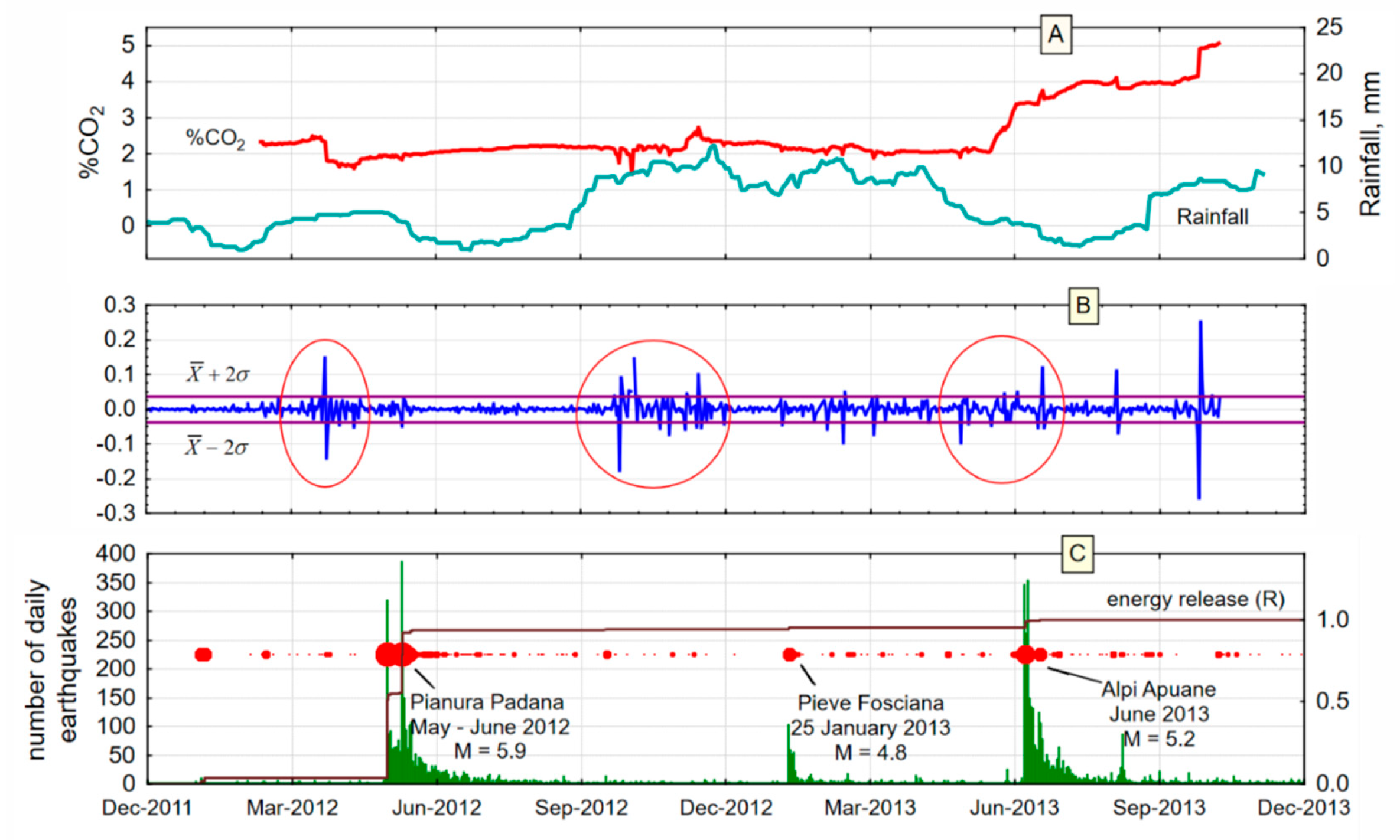
2.5. Toscana
2.6. Umbria
2.7. Marche
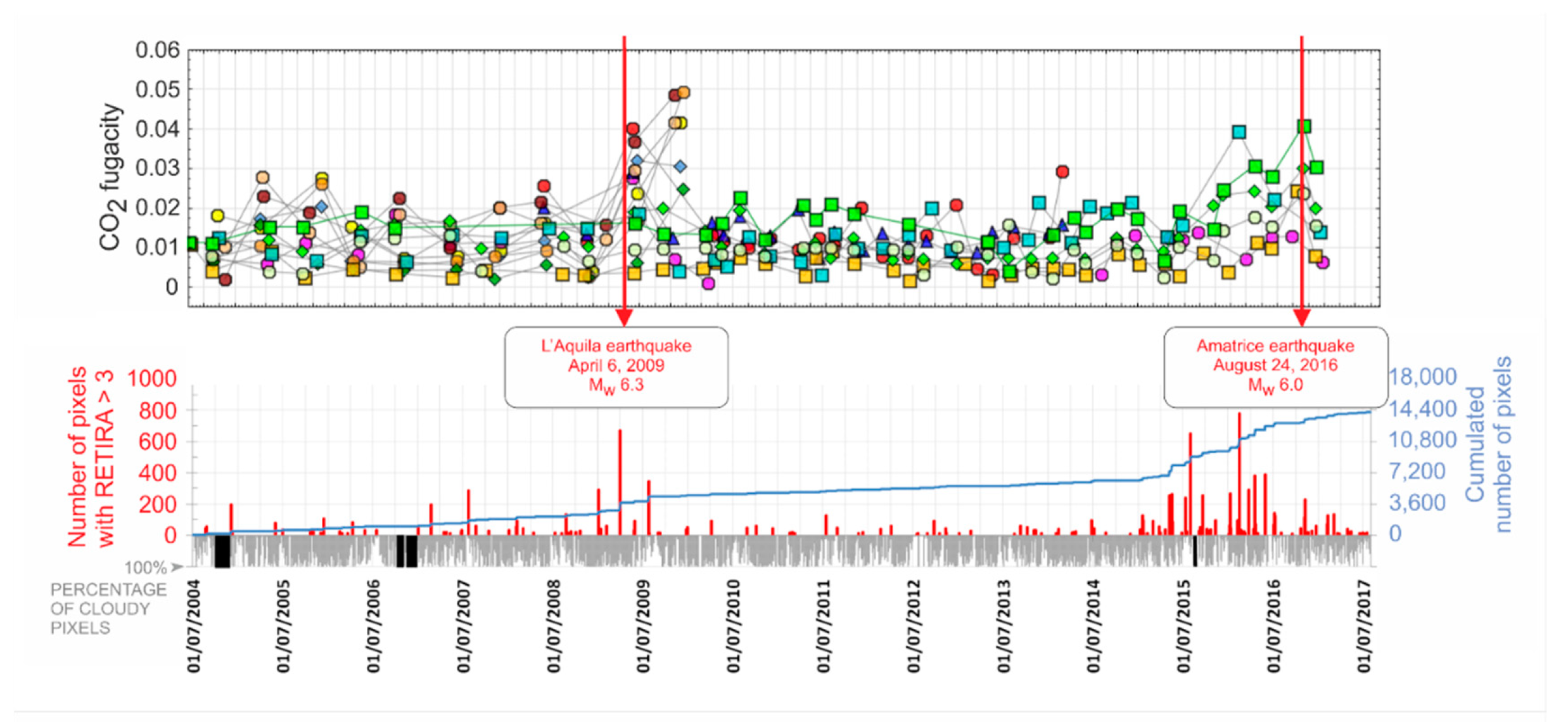
2.8. Abruzzo
2.9. Lazio
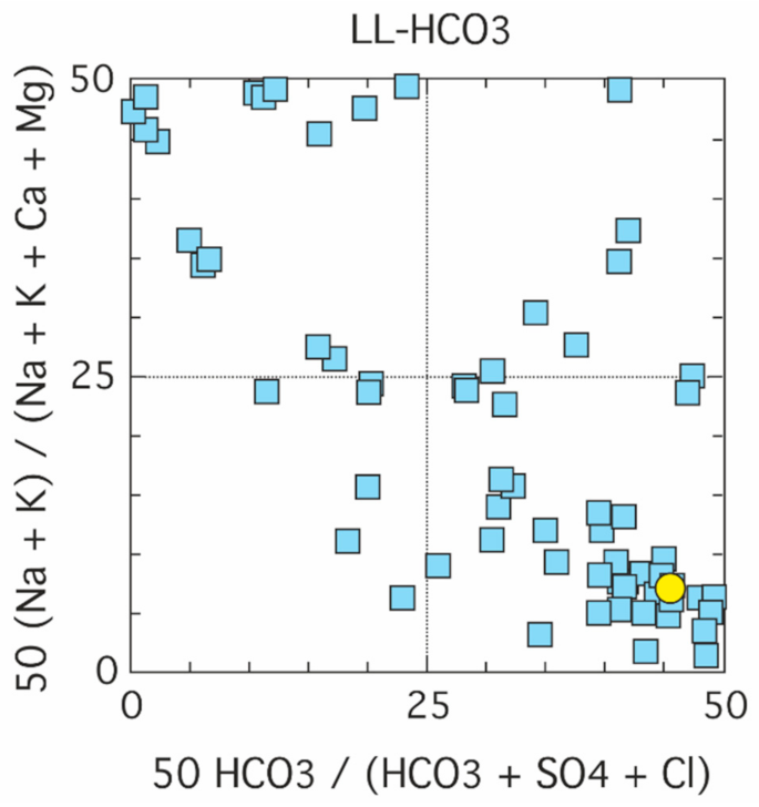
2.10. Basilicata
2.11. Campania
2.12. Sicilia
3. Quality and Reliability of the Observed Data
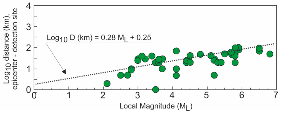
4. Possible Correlation between Epicentral Distance and Magnitude
5. Towards an Italian Geofluids Monitoring Network
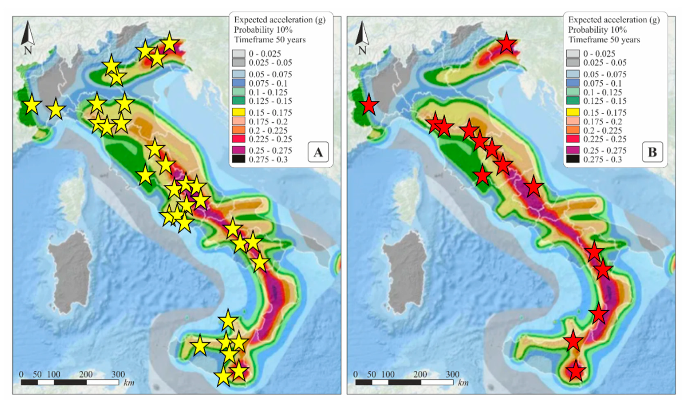
6. Priority Sites for the Implementation of a Geochemical Network
7. Conclusions
Supplementary Materials
Author Contributions
Funding
Institutional Review Board Statement
Informed Consent Statement
Data Availability Statement
Acknowledgments
Conflicts of Interest
References
- Woessner, J.; Laurentiu, D.; Giardini, D.; Crowley, H.; Cotton, F.; Grünthal, G.; Valensise, G.; Arvidsson, R.; Douglas, J. The 2013 European Seismic Hazard Model: Key components and results. Bull. Earthq. Eng. 2015, 13, 3553–3596. [Google Scholar] [CrossRef] [Green Version]
- Giardini, D.; Grünthal, G.; Shedlock, K.M.; Zhang, P. The GSHAP Global Seismic Hazard Map. In International Handbook of Earthquake & Engineering Seismology; International Geophysics Series 81 B; Lee, W., Kanamori, H., Jennings, P., Kisslinger, C., Eds.; Academic Press: Amsterdam, The Netherlands, 2003; pp. 1233–1239. [Google Scholar]
- Jordan, T.; Chen, Y.T.; Gasparini, P.; Madariaga, R.; Main, I.; Marzocchi, W.; Papadupoulos, G.; Sobolev, G.; Yamaoka, K.; Zschau, J. Operational earthquake forecasting—State of knowledge and guidelines for utilization. Ann. Geophys. 2011, 54, 316–391. [Google Scholar]
- Kossobokov, V.; Peresan, A.; Panza, G.F. On operational earthquake forecast and prediction problems. Seismol. Res. Lett. 2015, 86, 287–290. [Google Scholar] [CrossRef] [Green Version]
- Cicerone, R.D.; Ebel, J.E.; Britton, J. A systematic compilation of earthquake precursors. Tectonophysics 2009, 476, 371–396. [Google Scholar] [CrossRef]
- Wyss, M. Evaluation of Proposed Earthquake Precursors; American Geophysical Union: Washington, DC, USA, 1991; p. 94. [Google Scholar]
- Martinelli, G. Previous, current, and future trends in research into earthquake precursors in geofluids. Geosciences 2020, 10, 189. [Google Scholar] [CrossRef]
- Stucchi, M.; Meletti, C.; Montaldo, V.; Crowley, H.; Calvi, G.M.; Boschi, E. Seismic Hazard Assessment (2003–2009) for the Italian Building Code. Bull. Seismol. Soc. Am. 2011, 101, 1885–1911. [Google Scholar] [CrossRef]
- Meletti, C.; Marzocchi, W.; D’Amico, V.; Luzi, L.; Martinelli, F.; Pace, B.; Rovida, A.; Visini, F. The new Italian Seismic Hazard model (MPS19). In American Geophysical Union, Fall Meeting 2019; #NH23A-03, abstract; American Geophysical Union: Washington, DC, USA, 2019; Available online: https://ui.adsabs.harvard.edu/abs/2019AGUFMNH23A.03M/abstract (accessed on 18 January 2021).
- Dall’Aglio, M. Earthquake prediction by hydrogeochemical methods. Rend. Soc. Ital. Mineral. Petrol. 1976, 32, 421–436. [Google Scholar]
- Carapezza, M.; Nuccio, P.M.; Valenza, M. Geochemical precursors of earthquakes. In High Pressure Science and Technology; Vodar, B., Marteau, P.H., Eds.; Pergamon Press: New York, NY, USA, 1980; pp. 90–103. [Google Scholar]
- Martinelli, G. Hydrogeologic and geochemical precursors of earthquakes: An assessment for possible applications. Boll. Geofis. Teor. Appl. 2015, 56, 83–94. [Google Scholar] [CrossRef]
- Binda, G.; Pozzi, A.; Michetti, A.M.; Noble, P.J.; Rosen, M.R. Towards the understanding of hydrogeochemical seismic responses in karst aquifers: A retrospective meta-analysis focused on the Apennines (Italy). Minerals 2020, 10, 1058. [Google Scholar] [CrossRef]
- De Gregorio, S.; Federico, C.; Cappuzzo, S.; Favara, R.; Giudice, G.; Gurrieri, S.; Boschi, E. Multi-parametric monitoring system of associated seismic phenomenology and unusual animal behaviour in western Piedmont. Geofluids 2012, 12, 142–149. [Google Scholar] [CrossRef]
- De Liso, G.; Fidani, C.; Viotto, A. Stress-induced temperature variations in groundwaters of the Monferrato area (north-western Italy). Adv. Res. 2014, 2, 303–319. [Google Scholar] [CrossRef]
- Facchini, U.; Magnoni, S.; Sordelli, C. Rodigo 1, Northern Italy: A geothermal complex for agriculture. Geothermics 1993, 22, 135–147. [Google Scholar] [CrossRef]
- Martinelli, G. Fluidodynamical and chemical features of Radon 222 related to total gases: Implications for earthquake prediction. In Isotopic and Geochemical Precursors of Earthquakes and Volcanic Eruptions; IAEA: Vienna, Austria, 1993; pp. 48–62. [Google Scholar]
- Balderer, W.; Leuenberger, F. Observation of fluorescence spectra of groundwater in areas of tectonic activity: Could it act as a precursor of earthquakes? In Proceedings of the International Brainstorming Session on Geochemical Precursors for Earthquakes, Kolkata, India, 11–13 September 2006; Sen, P., Das, N.K., Eds.; pp. 22–30. [Google Scholar]
- Petrini, R.; Italiano, F.; Riggio, A.; Sleiko, F.F.; Santulin, M.; Buccianti, A.; Bonfanti, P.; Slejko, D. Coupling geochemical and geophysical signatures to constrain strain changes along thrust faults. Boll. Geofis. Teor. Appl. 2012, 53, 113–134. [Google Scholar] [CrossRef]
- Garavaglia, M.; Braitenberg, C.; Zadro, M.; Quattrocchi, F. Radon measurements in soil and water in the seismic Friuli area. II Nuovo Cim. 1990, 22, 415–422. [Google Scholar]
- Riggio, A.; Sancin, S. Radon measurements in Friuli (N.E. Italy and earthquakes: First results. Boll. Geofis. Teor. Appl. 2005, 46, 47–58. [Google Scholar]
- Rossi, G.; Fabris, P.; Zuliani, D. Overpressure and fluid diffusion causing non-hydrological transient GNSS displacements. Pure Appl. Geophys. 2018, 175, 1869–1888. [Google Scholar] [CrossRef]
- Albarello, D.; Martinelli, G. Piezometric levels as possible geodynamic indicators: Analysis of the data from a regional deep waters monitoring network in northern Italy. Geophys. Res. Lett. 1994, 21, 1955–1958. [Google Scholar] [CrossRef]
- Martinelli, G.; Albarello, D.; Mucciarelli, M. Radon emissions from mud volcanoes in northern Italy: Possible connection in the local seismicity. Geophys. Res. Lett. 1995, 22, 1989–1992. [Google Scholar] [CrossRef]
- Heinicke, J.; Italiano, F.; Koch, U.; Martinelli, G.; Telesca, L. Anomalous fluid emission of a deep borehole in a seismically active area of Northern Apennines (Italy). Appl. Geochem. 2010, 25, 555–571. [Google Scholar] [CrossRef]
- Fidani, C.; Balderer, W.; Leuenberger, F. The possible influences of the 2012 modena earthquakes on the fluorescence spectra of bottled mineral water. Hydrol. Curr. Res. 2017, 8, 288. [Google Scholar] [CrossRef]
- Heinicke, J.; Braun, T.; Burgassi, P.; Italiano, F.; Martinelli, G. Gas flow anomalies in seismogenic zones in the Upper Tiber Valley, Central Italy. Geophys. J. Int. 2006, 167, 794–806. [Google Scholar] [CrossRef]
- Cioni, R.; Guidi, M.; Pierotti, L.; Scozzari, A. An automatic monitoring network installed in Tuscany (Italy) for studying possible geochemical precursory phenomena. Nat. Hazards Earth Syst. Sci. 2007, 7, 405–416. [Google Scholar] [CrossRef] [Green Version]
- Pierotti, L.; Botti, F.; D’Intinosante, V.; Facca, G.; Gherardi, F. Anomalous CO2 content in the Gallicano thermo-mineral spring (Serchio Valley, Italy) before the 21 June 2013, Alpi Apuane earthquake (M = 5.2). Phys. Chem. Earth 2015, 85–86, 131–140. [Google Scholar] [CrossRef]
- Pierotti, L.; Gherardi, F.; Facca, G.; Piccardi, L.; Moratti, G. Detecting CO2 anomalies in a spring on Mt. Amiata volcano. Phys. Chem. Earth 2017, 98, 161–172. [Google Scholar] [CrossRef]
- Gherardi, F.; Pierotti, L. The suitability of the Pieve Fosciana hydrothermal system (Italy) as a detection site for geochemical seismic precursors. Appl. Geochem. 2018, 92, 166–179. [Google Scholar] [CrossRef]
- Makridakis, S.; Wheelwright, S.C.; Hyndman, R.J. Forecasting Methods and Applications, 3rd ed.; John Wiley and Sons: New York, NY, USA, 1998; p. 642. [Google Scholar]
- Gutenberg, B. The energy of earthquakes. Quart. J. Geol. Soc. Lond. 1956, 112, 1–14. [Google Scholar] [CrossRef]
- Italiano, F.; Martinelli, G.; Nuccio, P.M. Anomalies of mantle derived helium during the 1997-1998 seismic swarm of Umbria-Marche, Italy. Geophys. Res. Lett. 2001, 28, 839–842. [Google Scholar] [CrossRef]
- Italiano, F.; Martinelli, G.; Rizzo, A. Geochemical evidence of seismogenic-induced anomalies in the dissolved gases of thermal waters: A case study of Umbria (Central Apennines, Italy) both during and after the 1997–1998 seismic swarm. Geochem. Geophys. Geosystems 2004, 5. [Google Scholar] [CrossRef] [Green Version]
- Italiano, F.; Caracausi, A.; Favara, R.; Innocenzi, P.; Martinelli, G. Geochemical monitoring of cold waters during seismicity:implications for earthquake-induced modification in shallow aquifers. Terr. Atmos. Ocean. Sci. 2005, 16, 709–729. [Google Scholar] [CrossRef] [Green Version]
- Caracausi, A.; Italiano, F.; Martinelli, G.; Paonita, A.; Rizzo, A. Long-term geochemical monitoring and extensive/compressive phenomena: Case study of the Umbria Region (Central Apennines, Italy). Ann. Geophys. 2005, 48, 43–53. [Google Scholar] [CrossRef]
- Lapenna, V.; Martinelli, G.; Telesca, L. Long-range correlation analysis of earthquake-related geochemical variations recorded in Central Italy. Chaos. Solitons. Fractals. 2004, 21, 491–500. [Google Scholar] [CrossRef]
- Quattrocchi, F.; Pik, R.; Pizzino, L.; Guerra, M.; Scarlato, P.; Angelone, M.; Barbieri, M.; Conti, A.; Marty, B.; Sacchi, E.; et al. Geochemical changes at the Bagni di Triponzo thermal spring during the Umbria-Marche 1997–1998 seismic sequence. J. Seismol. 2000, 4, 567–587. [Google Scholar] [CrossRef]
- Heinicke, J.; Martinelli, G.; Telesca, L. Geodynamically induced variations in the emission of CO2 gas at San Faustino (Central Apennines, Italy). Geofluids 2012, 12, 123–132. [Google Scholar] [CrossRef]
- Dadomo, A.; Lemmi, M.; Martinelli, G.; Menichetti, M.; Telesca, L. Springwater continuous monitoring in the L’Aquila area in concomitance with the April 2009 seismic swarm in central Italy: Constraining factors to possible deep-seated fluid emissions. Chem. Geol. 2013, 339, 169–176. [Google Scholar] [CrossRef]
- Plastino, W.; Povinec, P.P.; De Luca, G.; Doglioni, C.; Nisi, S.; Ioannucci, L.; Balata, M.; Laubenstein, M.; Bella, F.; Coccia, E. Uranium groundwater anomalies and L’Aquila earthquake, 6th April 2009 (Italy). J. Environ. Radioact. 2010, 101, 45–50. [Google Scholar] [CrossRef]
- Barberio, M.D.; Barbieri, M.; Billi, A.; Doglioni, C.; Petitta, M. Hydrogeochemical changes before and during the 2016 Amatrice-Norcia seismic sequence (central Italy). Sci. Rep. 2017, 7, 11735. [Google Scholar] [CrossRef]
- De Luca, G.; Di Carlo, G.; Tallini, M. A record of changes in the Gran Sasso groundwater before, during and after the 2016 Amatrice earthquake, central Italy. Sci. Rep. 2018, 8, 15982. [Google Scholar] [CrossRef]
- Martinelli, G.; Facca, G.; Genzano, N.; Gherardi, F.; Lisi, M.; Pierotti, L.; Tramutoli, V. Earthquake-related signals in Central Italy detected by hydrogeochemical and satellite techniques. Front. Earth Sci. 2020, 8, 584716. [Google Scholar] [CrossRef]
- Alessio, M.; Allegri, L.; Bella, F.; Della Monica, G.; Ermini, A.; Improta, S.; Biagi, P.F. Studies of some precursory phenomena for the Umbria earthquake of September 19, 1979. II Nuovo Cim. 1980, 3, 589–600. [Google Scholar] [CrossRef]
- Allegri, L.; Bella, F.; Della Monica, G.; Ermini, A.; Improta, S.; Sgrigna, V.; Biagi, P.F. Radon and tilt anomalies detected before the Irpinia (South Italy) earthquake of November 23, 1980 at great distances from the epicenter. Geophys. Res. Lett. 1983, 10, 269–272. [Google Scholar] [CrossRef]
- Dall’Aglio, M.; Funiciello, R.; Lombardi, S.; Boschi, E.; Gasparini, C. Research activities on earthquake premonitory events-present trends in Italy. In Proceedings of the ECE/UN Seminar on Prediction of Earthquakes, Lisbon, Portugal, 14–18 November 1988; Oliveira, C.S., Ed.; Volume 2, pp. 763–778. [Google Scholar]
- Lombardi, S.; Etiope, G.; Pinti, D.L. Variations of 222-Rn in soil gas as seismic precursor signals at Latera caldera (Central Italy). In Radon Monitoring in Radioprotection, Environmental and/or Earth Sciences; Furlan, G., Tommasino, L., Eds.; World Scientific: Singapore, 1993; pp. 418–434. [Google Scholar]
- Quattrocchi, F.; Calcara, M. Test-sites for Earthquake Prediction Experiments within the Colli Albani Region. Phys. Chem. Earth 1998, 23, 915–920. [Google Scholar] [CrossRef]
- Di Bello, G.; Heinicke, J.; Koch, U.; Lapenna, V.; Macchiato, M.; Martinelli, G.; Piscitelli, S. Geophysical and geochemical parameters jointly monitored in a seismic of Southern Apennines (Italy). Phys. Chem. Earth 1998, 23, 909–914. [Google Scholar] [CrossRef]
- Colangelo, G.; Heinicke, J.; Koch, U.; Lapenna, V.; Martinelli, G.; Telesca, L. Results of gas flux records in the seismically active area of Val d’Agri (Southern Italy). Ann. Geophys. 2005, 48, 55–63. Available online: http://hdl.handle.net/2122/880 (accessed on 18 January 2021).
- Colangelo, G.; Heinicke, J.; Lapenna, V.; Martinelli, G.; Mucciarelli, M.; Telesca, L. Investigating correlations of local seismicity with anomalous geoelectrical, hydrogeological and geochemical signals jointly recorded in Basilicata region (Southern Italy). Ann. Geophys. 2007, 50, 527–538. Available online: http://hdl.handle.net/2122/3866 (accessed on 18 January 2021).
- Ghiara, M.R.; Stanzione, D.; Petti, C. Chemical and isotope characterizations of the deep waters of the high valley of the River Sele (Italy): Correlations between geochemical parameters and seismic activity. Ital. J. Geosci. 1994, 113, 521–537. [Google Scholar]
- Molin, P.; Acocella, V.; Funiciello, R. Structural, seismic and hydrothermal features at the border of anactive intermittent resurgent block: Ischia Island (Italy). J. Volcanol. Geotherm. Res. 2003, 121, 65–81. [Google Scholar] [CrossRef]
- Mongelli, F.; Harabaglia, P.; Martinelli, G.; Squarci, P.; Zito, G. Nuove misure di flusso geotermico in Italia meridionale: Possibili implicazioni sismotettoniche. In Proceedings of the Atti 14° convegno GNGTS, Roma, Italy, 23–25 October 1995; pp. 929–940. [Google Scholar]
- Duchi, V.; Minissale, A.; Vaselli, O.; Ancillotti, M. Hydrogeochemistry of the Campania region in southern Italy. J. Volcanol. Geotherm. Res. 1995, 67, 313–328. [Google Scholar] [CrossRef]
- Balderer, W.; Martinelli, G. Geochemistry of groundwaters and gases occurring in the 23 November, 1980 earthquake area (South Italy). Environ. Geochem. Health 1995, 16, 147–164. [Google Scholar]
- Langelier, W.F.; Ludwig, H.F. Graphical methods for indicating the mineral character of natural waters. J. Am. Water Works Assoc. 1942, 34, 335. [Google Scholar] [CrossRef]
- Del Pezzo, E.; Gasparini, P.; Mantovani, M.S.M.; Martini, M.; Capaldi, G.; Gomes, Y.T.; Pece, R. A case of correlation between Rn anomalies and seismic activity on a volcano (Vulcano Island, Southern Tyrrhenian Sea). Geophys. Res. Lett. 1981, 8, 962–965. [Google Scholar] [CrossRef]
- Quattrocchi, F.; Di Stefano, G.; Pizzino, L.; Pongetti, F.; Romeo, G.; Scarlato, P.; Sciacca, U.; Urbini, G. Geochemical Monitoring System 2 prototype (GMS2) installation at the “Acqua Difesa” well, within the Etna region: First data during the 1999 volcanic crisis. J. Volcanol. Geotherm. Res. 2000, 101, 273–306. [Google Scholar] [CrossRef]
- Immè, G.; La Delfa, S.; Lo Nigro, S.; Morelli, D.; Patanè, G. Gas Radon emission related to geodynamic activity of Mt. Etna. Ann. Geophys. 2005, 48, 65–67. [Google Scholar]
- Cigolini, C.; Laiolo, M.; Coppola, D. Earthquake-volcano interactions detected from radon degassing at Stromboli (Italy). Earth Planet. Sci. Lett. 2007, 257, 511–525. [Google Scholar] [CrossRef]
- Favara, R.; Grassa, F.; Madonia, P.; Valenza, M. Flow Changes and Geochemical Anomalies in Warm and Cold Springs Associated with the 1992-1994 Seismic Sequence at Pollina, Central Sicily, Italy. Pure Appl. Geophys. 2007, 164, 2411–2430. [Google Scholar] [CrossRef]
- Camarda, M.; De Gregorio, S.; Di Martino, R.M.R.; Favara, R. Temporal and spatial correlations between soil CO2 flux and crustal stress. J. Geophys. Res. 2016, 121, 7071–7085. [Google Scholar] [CrossRef]
- Dall’Aglio, M.; Quattrocchi, F.; Tersigni, S. Geochemical evolution of groundwater of the Iblean Foreland (Southeastern Sicily) after the December, 1990 earthquake (M=5.4). Ann. Geofis. 1995, 38, 309–329. [Google Scholar]
- Bonfanti, P.; Carapezza, M.L.; D’Alessandro, W.; De Domenico, R.; Diliberto, I.S.; Di Liberto, R.; Giammanco, S.; Gurrieri, S.; Parello, F.; Valenza, M. Earthquake of December 13, 1990 in eastern Sicily: Some geochemical investigations. In Proceedings of the Colloquio Scientifico Sulla Protezione Sismica, Venice, Italy, 12–13 July 1993; Spagna, V., Schiavon, E., Eds.; pp. 176–184. [Google Scholar]
- Aureli, A.; Fazio, F.; Pistorio, G. Alcuni esempi di variazioni di livello piezometrico come precursori di fenomeni sismici. In Proceedings of the Atti del 2° Convegno Internazionale di Geoidrologia, Firenze, Italy, 29 November–3 December 1993; published on 1995. pp. 57–67. [Google Scholar]
- Rovida, A.; Locati, M.; Camassi, R.; Lolli, B.; Gasperini, P. The Italian earthquake catalogue CPTI15. Bull. Earthq. Eng. 2020, 18, 2953–2984. [Google Scholar] [CrossRef]
- Roeloffs, E.A. Hydrologic precursors to earthquakes: A review. Pure Appl. Geophys. 1988, 126, 177–209. [Google Scholar] [CrossRef]
- Kumpel, H.-J. Pore-pressure variation as a precursory phenomenon: The need for and a list of supplementary data. Tectonophysics 1991, 193, 377–383. [Google Scholar] [CrossRef]
- Woith, H. Radon earthquake precursor: A short review. Eur. Phys. J. Spec. Top. 2015, 224, 611–627. [Google Scholar] [CrossRef]
- Igarashi, G.; Wakita, H. Groundwater radon anomalies associated with earthquakes. Tectonophysics 1990, 180, 237–254. [Google Scholar] [CrossRef]
- Martinelli, G.; Tamburello, G. Geological and geophysical factors constraining the occurrence of earthquake precursors in geofluids: A review and reinterpretation. Front. Earth Sci. 2020. [Google Scholar] [CrossRef]
- Tamburello, G.; Pondrelli, S.; Chiodini, G.; Rouwet, D. Global-scale control of extensional tectonics on CO2 Earth degassing. Nat. Commun. 2018, 9, 4608. [Google Scholar] [CrossRef] [PubMed]
- Barbieri, M.; Boschi, E.; Dall’Aglio, M.; Fornaseri, M.; Funiciello, R.; Gasparini, C.; Lombardi, S.; Parotto, M.; Taddeucci, A.; Tonani, F. Programma di ricerca sui precursori geochimici. In Proceedings of the Atti 6° Convegno Nazionale GNGTS, CNR, Roma, Italy, 14–16 December 1987; pp. 73–96. [Google Scholar]
- Luongo, G. Un programma nazionale per la previsione dei terremoti e delle eruzioni vulcaniche. In Sono Prevedibili i Terremoti e le Eruzioni Vulcaniche? Proceedings of the Atti del Convegno Scientifico di Taormina, Taormina, Italy, 13–14 April 1989; ING-CNR-GNV-GNDT; Giorgetti, E., Ed.; Presidenza del Consiglio dei Ministri, Dipartimento della Protezione Civile: Roma, Italy, 1989; pp. 188–206. [Google Scholar]
- Bella, F. Stato attuale delle ricerche sperimentali sui premonitori fisici dei terremoti in Italia. In Terremoti in Italia-Previsione e Prevenzione dei Danni; Atti dei Convegni Lincei; Accademia Nazionale dei Lincei: Roma, Italy, 1995; pp. 239–250. [Google Scholar]
- Calcara, M.; Quattrocchi, F.; Romeo, G.; Sciacca, U. Geochimica dei fluidi applicata alla previsione di terremoti e alla sismotettonica di aree sismiche e vulcaniche Italiane. In "Terremoti in Italia", Atti dei Convegni Lincei; Accademia Nazionale dei Lincei: Roma, Italy, 1995; pp. 330–339. [Google Scholar]
- Doglioni, C. Discorso del Presidente dell’Istituto Nazionale di Geofisica e Vulcanologia Nella Cerimonia per il Ventennale dell’INGV. 2019. Available online: http://www.ingv.it/it/discorso-del-presidente (accessed on 26 August 2020).
- Camarda, M.; Caracausi, A.; Chiaraluce, L.; De Gregorio, S.; Favara, R. Two years of geochemical monitoring along the Alto Tiberina Fault (Italy): New inferences on fluids and seismicity in central Apennines. In Proceedings of the 20th EGU General Assembly, EGU2018, Vienna, Austria, 4–13 April 2018. [Google Scholar]
- Martinelli, G.; Albarello, D. Main constraints for siting monitoring networks devoted to the study of earthquake related hydrogeochemical phenomena in Italy. Ann. Geofis. 1997, 40, 1505–1525. [Google Scholar]
- Irwin, W.P.; Barnes, I. Tectonic relations of carbon dioxide discharges and earthquakes. J. Geophys. Res. 1980, 85, 3115–3121. [Google Scholar] [CrossRef]
- Montone, P.; Amato, A.; Pondrelli, S. Active stress map of Italy. J. Geophys. Res. 1999, 104, 25595–25610. [Google Scholar] [CrossRef]
- Vannoli, P.; Martinelli, G.; Valensise, G. The seismotectonic significance of geofluids in Italy. Front. Earth Sci. 2021. [Google Scholar] [CrossRef]


Publisher’s Note: MDPI stays neutral with regard to jurisdictional claims in published maps and institutional affiliations. |
© 2021 by the authors. Licensee MDPI, Basel, Switzerland. This article is an open access article distributed under the terms and conditions of the Creative Commons Attribution (CC BY) license (http://creativecommons.org/licenses/by/4.0/).
Share and Cite
Martinelli, G.; Ciolini, R.; Facca, G.; Fazio, F.; Gherardi, F.; Heinicke, J.; Pierotti, L. Tectonic-Related Geochemical and Hydrological Anomalies in Italy during the Last Fifty Years. Minerals 2021, 11, 107. https://doi.org/10.3390/min11020107
Martinelli G, Ciolini R, Facca G, Fazio F, Gherardi F, Heinicke J, Pierotti L. Tectonic-Related Geochemical and Hydrological Anomalies in Italy during the Last Fifty Years. Minerals. 2021; 11(2):107. https://doi.org/10.3390/min11020107
Chicago/Turabian StyleMartinelli, Giovanni, Riccardo Ciolini, Gianluca Facca, Francesco Fazio, Fabrizio Gherardi, Jens Heinicke, and Lisa Pierotti. 2021. "Tectonic-Related Geochemical and Hydrological Anomalies in Italy during the Last Fifty Years" Minerals 11, no. 2: 107. https://doi.org/10.3390/min11020107