
Dendrochronological Potential of Drought-Sensitive Tree Stands in Armenia for the Hydroclimate Reconstruction of the Lesser Caucasus

 ,
,  ,
,  and
and
Abstract
:
1. Introduction
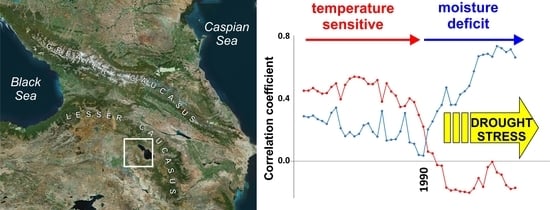
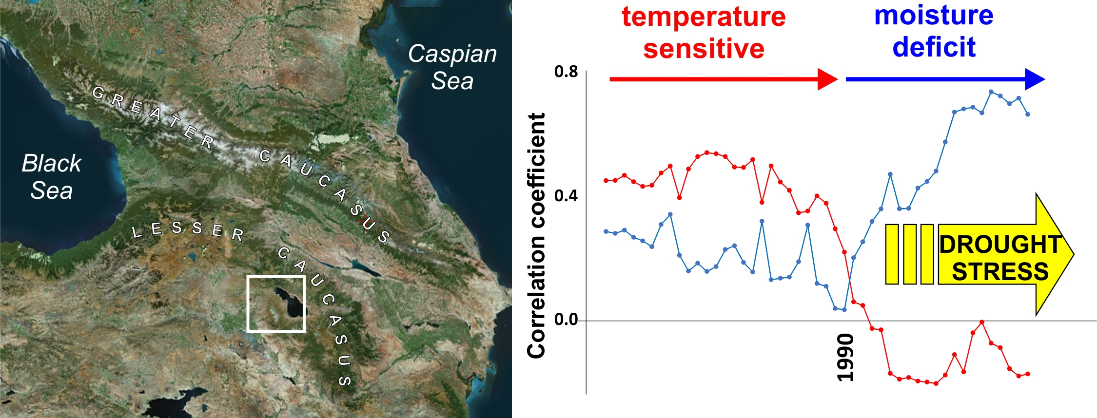
2. Study Area
3. Materials and Methods
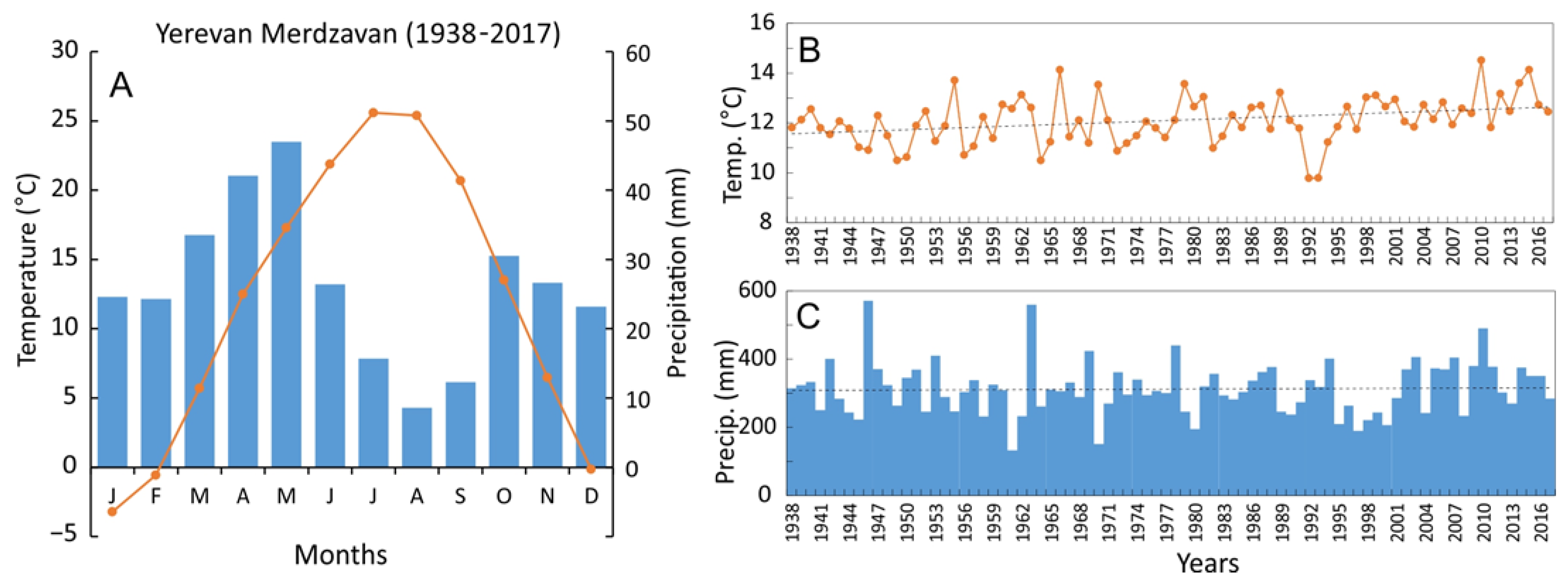
3.1. Site Description
3.2. Field Sampling and Laboratory Methods
3.3. Climate Data and Dendroclimatological Analysis
4. Results and Discussion
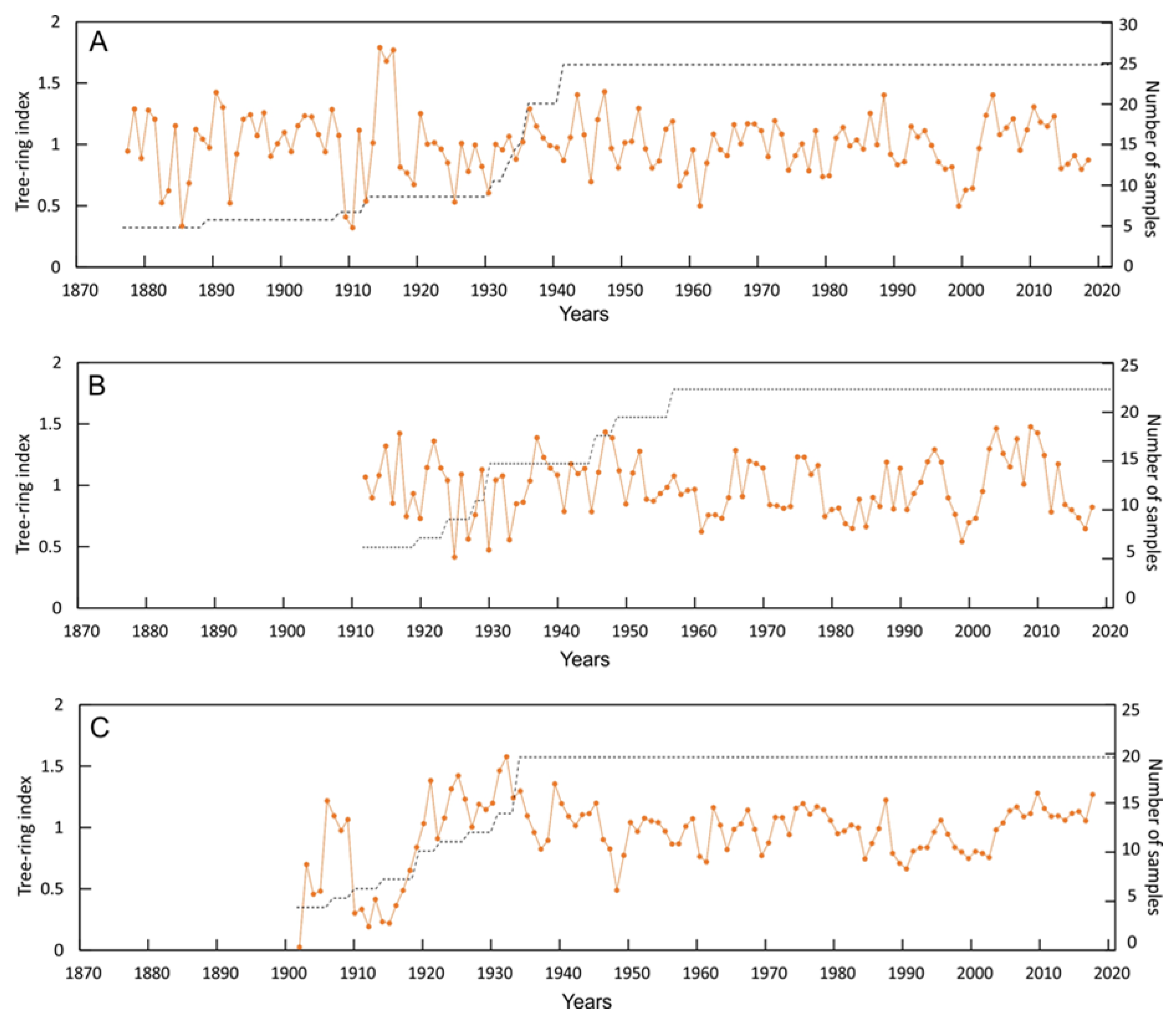
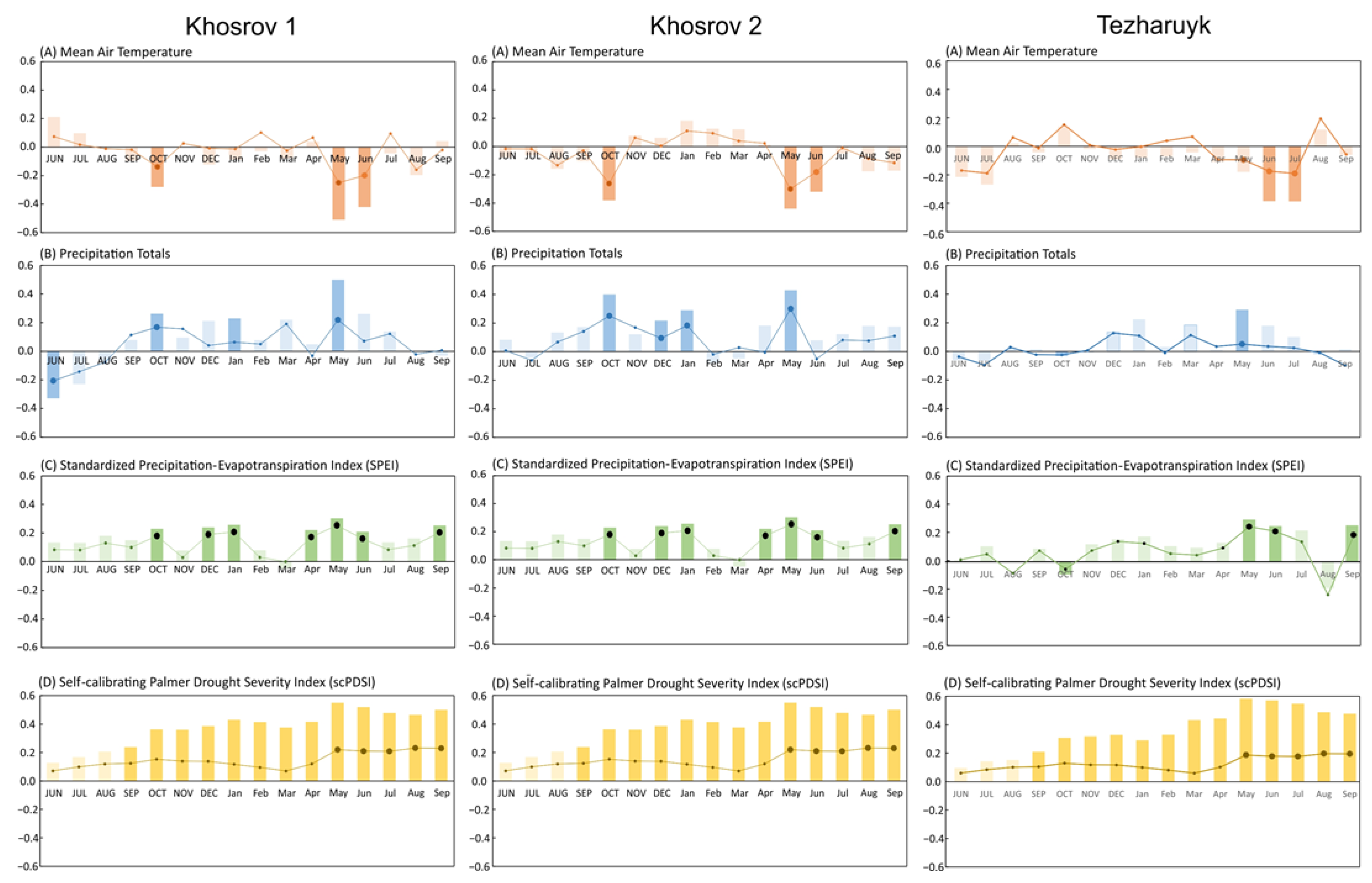
4.1. Characteristics of Juniperus Polycarpos and Quercus Macranthera Tree-Ring Width Chronologies
4.2. Climate and Tree-Growth Relationships
4.3. Stability of Climate–Growth Correlations
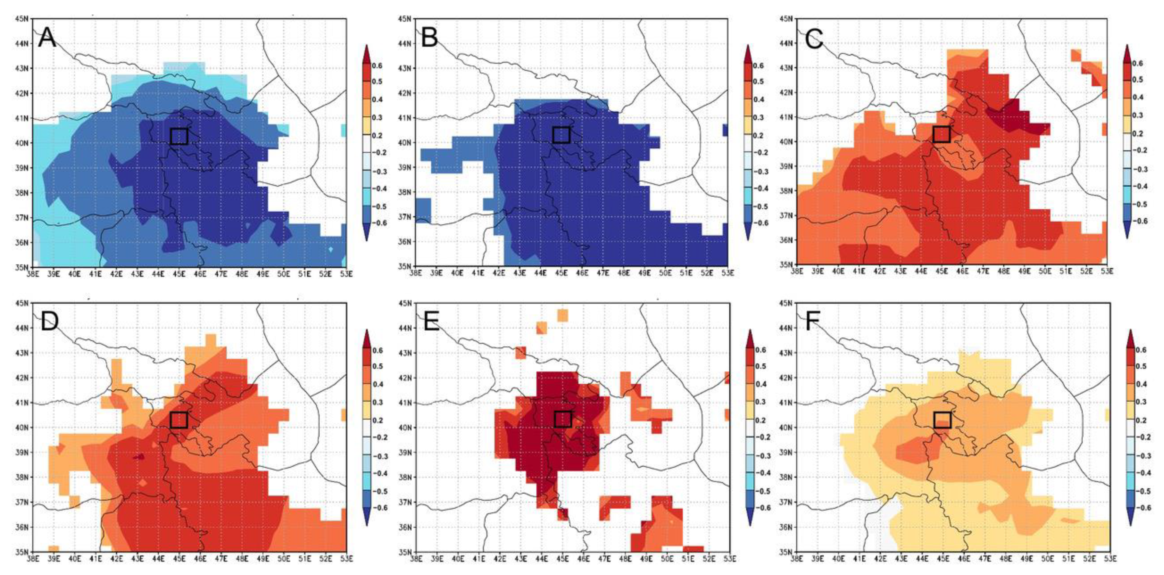
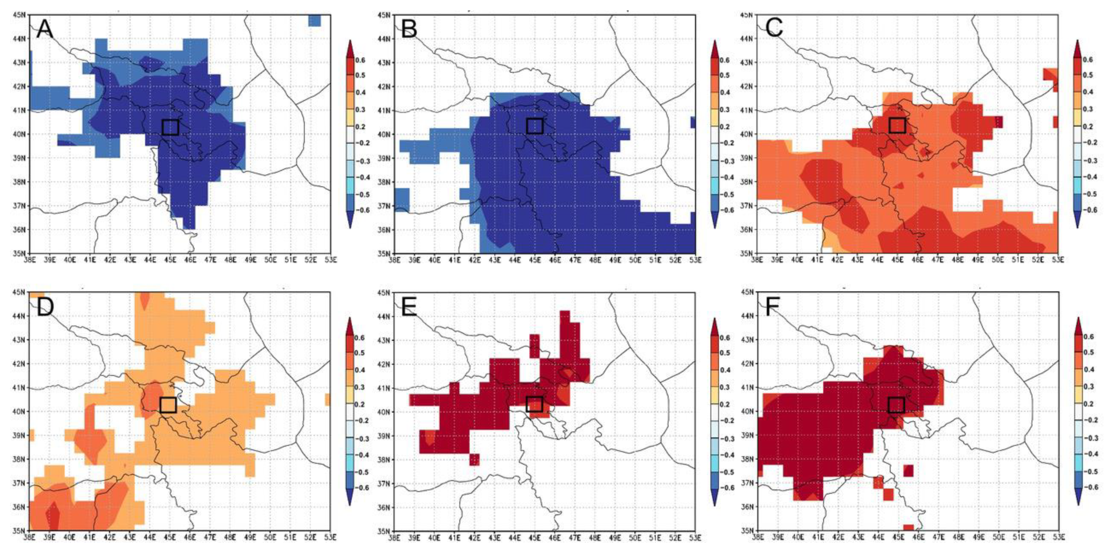
4.4. Spatial Pattern of Climate–Growth Correlations
4.5. Influence of Extreme Climatic Conditions on Juniper and Oak Growth
5. Conclusions
Author Contributions
Funding
Institutional Review Board Statement
Informed Consent Statement
Data Availability Statement
Acknowledgments
Conflicts of Interest
References
- Gevorgyan, A. Main types of synoptic processes and circulation types generating heavy precipitation events in Armenia. Meteorol. Atmos. Phys. 2013, 122, 91–102. [Google Scholar] [CrossRef]
- Galstyan, H.; Sfîcă, L.; Ichim, P. Long Term Variability of Annual Temperature in Armenia in the Context of Changing Climate. Int. J. Environ. Chem. Ecol. Geol. Geophys. Eng. 2016, 10, 19–25. [Google Scholar]
- Alexandryan, G. Precipitation in the Armenian SSR; Yerevan, Armenia, 1971; pp. 1–178. (In Russian) [Google Scholar]
- Melkonyan, A.; Asadoorian, M.O. Climate impact on agroeconomy in semiarid region of Armenia. Environ. Dev. Sustain. 2014, 16, 393–414. [Google Scholar] [CrossRef]
- Gevorgyan, A. Verification of daily precipitation amount forecasts in Armenia by ERA-Interim model. Int. J. Clim. 2012, 33, 2706–2712. [Google Scholar] [CrossRef]
- Saiadian, Y. Lake Sevan—Natural climatogram of the Holocene. In Voprosy Geologii Golotsena; Yerevan, Armenia, 1985; pp. 61–67. (In Russian) [Google Scholar]
- Gorbatov, E.S.; Vardanyan, A.A.; Korzhenkov, A.M.; Razumniy, S.D. Lake Sevan (Armenia) Deposits as Indicator of Paleoclimate and Neotectonic Processes. Izv. Atmos. Ocean. Phys. 2019, 55, 860–869. [Google Scholar] [CrossRef]
- Ollivier, V.; Joannin, S.; Roiron, P.; Nahapetyan, S.; Chataigner, C. Travertinization and Holocene morphogenesis in Armenia: A reading grid of rapid climatic changes impact on the landscape and societies between 9500-4000 cal. BP in the Circumcaspian regions? Eur. Archaeol. 2011, 36, 26–31. [Google Scholar]
- Joannin, S.; Ali, A.A.; Ollivier, V.; Roiron, P.; Peyron, O.; Chevaux, S.; Nahapetyan, S.; Tozalakyan, P.; Karakhanyan, A.; Chataigner, C. Vegetation, fire and climate history of the Lesser Caucasus: A new Holocene record from Zarishat fen (Armenia). J. Quat. Sci. 2014, 29, 70–82. [Google Scholar] [CrossRef]
- Bradley, R.S. Paleoclimatology: Reconstructing Climates of the Quaternary, 3rd ed.; Elsevier/Academic: Amsterdam, The Netherlands, 2015; pp. 1–696. [Google Scholar]
- Fritts, H.C. Tree Rings and Climate; Academic Press: New York, NY, USA, 1976; pp. 1–582. [Google Scholar]
- Dobbertin, M. Tree growth as indicator of tree vitality and of tree reaction to environmental stress: A review. Eur. J. For. Res. 2005, 124, 319–333. [Google Scholar] [CrossRef]
- Schuster, R.; Oberhuber, W. Drought sensitivity of three co-occurring conifers within a dry inner Alpine environment. Trees 2013, 27, 61–69. [Google Scholar] [CrossRef] [Green Version]
- Pederson, N.; Jacoby, G.C.; D’Arrigo, R.D.; Cook, E.R.; Buckley, B.M.; Dugarjav, C.; Mijiddorj, R. Hydrometeorological Reconstructions for Northeastern Mongolia Derived from Tree Rings: 1651–1995. J. Clim. 2001, 14, 872–881. [Google Scholar] [CrossRef]
- Davi, N.K.; Jacoby, G.C.; D’Arrigo, R.D.; Baatarbileg, N.; Jinbao, L.; Curtis, A.E. A tree-ring based drought index reconstruction for far western Mongolia: 1565–2004. Int. J. Clim. 2009, 29, 1508–1514. [Google Scholar] [CrossRef]
- Li, J.; Gou, X.; Cook, E.R.; Chen, F. Tree-ring based drought reconstruction for the central Tien Shan area in northwest China. Geophys. Res. Lett. 2006, 33, L07715. [Google Scholar] [CrossRef] [Green Version]
- Chen, F.; Yuan, Y.J.; Wei, W.S.; Yu, S.L.; Zhang, T.W.; Shang, H.M.; Zhang, R.; Qin, L.; Fan, Z. Tree-ring recorded hydroclimatic change in Tienshan mountains during the past 500 years. Quat. Int. 2015, 358, 35–41. [Google Scholar] [CrossRef]
- Opała, M.; Niedźwiedź, T.; Rahmonov, O.; Owczarek, P.; Małarzewski, Ł. Towards improving the Central Asian dendrochronological network—New data from Tajikistan, Pamir-Alay. Dendrochronologia 2017, 41, 10–23. [Google Scholar] [CrossRef]
- Opała-Owczarek, M.; Niedźwiedź, T. Last 1100 yr of precipitation variability in western central Asia as revealed by tree-ring data from the Pamir-Alay. Quat. Res. 2019, 91, 81–95. [Google Scholar] [CrossRef] [Green Version]
- Opała-Owczarek, M.; Owczarek, P. Dry and Humid Periods Reconstructed from Tree Rings in the Former Territory of Sogdiana (Central Asia) and Their Socio-economic Consequences over the Last Millennium. In Socio-Environmental Dynamics along the Historical Silk Road; Yang, L., Bork, H.R., Fang, X., Mischke, S., Eds.; Springer: Cham, Switzerland, 2019; pp. 195–214. [Google Scholar] [CrossRef] [Green Version]
- Azizi, G.; Arsalani, M.; Bräuning, A.; Moghimi, E. Precipitation variations in the central Zagros Mountains (Iran) since A.D. 1840 based on oak tree rings. Palaeogeogr. Palaeoclim. Palaeoecol. 2013, 386, 96–103. [Google Scholar] [CrossRef]
- Arsalani, M.; Pourtahamsi, K.; Azizi, G.; Bräuning, A.; Mohammadi, H. Tree-ring based December-February precipitation reconstruction in the southern Zagros Mountains, Iran. Dendrochronologia 2018, 49, 45–56. [Google Scholar] [CrossRef]
- Holobâcă, I.-H.; Pop, O.; Petrea, D. Dendroclimatic reconstruction of late summer temperatures from upper treeline sites in Greater Caucasus, Russia. Quat. Int. 2016, 415, 67–73. [Google Scholar] [CrossRef]
- Dolgova, E.A.; Solomina, O.N. First quantitative reconstruction of air temperature for the warm period in the Caucasus based on dendrochronological data. Dokl. Earth Sci. 2010, 431, 252–256. [Google Scholar] [CrossRef]
- Brugnoli, E.; Solomina, O.; Spaccino, L.; Dolgova, E. Climate signal in the ring width, density and carbon stable isotopes in pine (Pinus Sylvestris L.) in Central Caucasus. Geogr. Environ. Sustain. 2010, 3, 4–16. [Google Scholar] [CrossRef] [Green Version]
- Dolgova, E. June–September temperature reconstruction in the Northern Caucasus based on blue intensity data. Dendrochronologia 2016, 39, 17–23. [Google Scholar] [CrossRef]
- Köse, N.; Güner, H.T.; Harley, G.L.; Guiot, J. Spring temperature variability over Turkey since 1800CE reconstructed from a broad network of tree-ring data. Clim. Past 2017, 13, 1–15. [Google Scholar] [CrossRef] [Green Version]
- Martin-Benito, D.; Ummenhofer, C.C.; Köse, N.; Güner, H.T.; Pederson, N. Tree-ring reconstructed May–June precipitation in the Caucasus since 1752 CE. Clim. Dyn. 2016, 47, 3011–3027. [Google Scholar] [CrossRef]
- Jude, F.; Marguerie, D.; Badalyan, R.; Smith, A.T.; Delwaide, A. Wood resource management based on charcoals from the Bronze Age site of Gegharot (central Armenia). Quat. Int. 2016, 395 (Suppl. C), 31–44. [Google Scholar] [CrossRef] [Green Version]
- Adamia, S.A.; Chkhotua, T.; Kekelia, M.; Lordkipanidze, M.; Shavishvili, I.; Zakariadze, G. Tectonics of the Caucasus and adjoining regions: Implications for the evolution of the Tethys ocean. J. Struct. Geol. 1981, 3, 437–447. [Google Scholar] [CrossRef]
- Adamia, S.A.; Zakariadze, G.; Chkhotua, T.; Sadradze, N.; Tsereteli, N.; Chabukiani, A.; Gventsadze, A. Geology of the Caucasus: A Review. Turk. J. Earth Sci. 2011, 20, 489–544. [Google Scholar] [CrossRef]
- Arutyunyan, E.V.; Lebedev, V.A.; Chernyshev, I.V.; Sagatelyan, A.K. The geochronology of the Neogene/Quaternary volcanism in the Geghama highland, Lesser Caucasus, Armenia. In Doklady Earth Sciences; Springer: Berlin/Heidelberg, Germany, 2007; Volume 416, pp. 91–95. [Google Scholar] [CrossRef]
- Lebedev, V.A.; Chernyshev, I.V.; Shatagin, K.N.; Bubnov, N.; Yakushev, A.I. The quaternary volcanic rocks of the Geghama highland, Lesser Caucasus, Armenia: Geochronology, isotopic Sr-Nd characteristics, and origin. J. Volcanol. Seism. 2013, 7, 204–229. [Google Scholar] [CrossRef]
- ITRDBa, Chronologies Archived at the International Tree-Ring Data Bank Developed by (a) U. Buentgen, A. Nievergelt, A. Verstege. Available online: https://www.ncdc.noaa.gov/paleo-search/study/13877 (accessed on 10 May 2020).
- ITRDBb, Chronologies Archived at the International Tree-Ring Data Bank developed by (a) N. Riches and P.I. Kuniholm. Available online: https://www.ncdc.noaa.gov/paleo-search/study/4235 (accessed on 10 May 2020).
- ITRDBc, Chronologies Archived at the International Tree-Ring Data Bank Developed by (a) P.I. Kuniholm. Available online: https://www.ncdc.noaa.gov/paleo-search/study/3808 (accessed on 10 May 2020).
- Lydolph, P.E. Climates of the Soviet Union; Elsevier Scientific Publishing Company: Amsterdam, The Netherlands; New York, NY, USA, 1977; pp. 1–443. [Google Scholar]
- Gidrometeoizdat. Scientific and Applied Reference Book on the Climate of the USSR. Long-Term Data; Part 1–6, Issue 16; Gidrometeoizdat: Saint Petersburg, Russia, 1989. (In Russian) [Google Scholar]
- Galstyan, H.; Vardanyan, T. The Dynamics of Average Annual Air Temperature Changes in the Republic of Armenia. Proc. Ysu Ser. Geol. Geogr. 2017, 51, 68–71. [Google Scholar]
- Gevorgyan, A. Surface and tropospheric temperature trends in Armenia. Int. J. Climatol. 2014, 34, 3559–3573. [Google Scholar] [CrossRef]
- Bamston, A.G.; Livezey, R.E. Classification, Seasonality and Persistence of Low-Frequency Atmospheric Circulation Patterns. Mon. Weather Rev. 1987, 115, 1083–1126. [Google Scholar] [CrossRef]
- Xoplaki, E.; González-Rouco, J.F.; Luterbacher, J.; Wanner, H. Wet season Mediterranean precipitation variability: Influence of large-scale dynamics and trends. Clim. Dyn. 2004, 23, 63–78. [Google Scholar] [CrossRef] [Green Version]
- Galstyan, H.; Sfîcă, L.; Ichim, P. Long Term Variability of Annual Precipitation in Armenia in the Context of Changing Climate. An. Stiint. Univ. Alexandru Ioan Cuza Iasi-Ser. Geogr. 2015, 60, 5–16. [Google Scholar]
- Khosrov Forest State Preserve. Available online: http://www.armeniapedia.org/index.php?title=Khosrov_Forest_State_Preserve (accessed on 22 November 2020).
- Gabrielian, E.T.S. The conservation of rare threatened species and types of vegetation in Armenia. In Anales del Jardín Botánico de Madrid; Real Jardín Botánico: Madrid, Spain, 1981; Volume 37, pp. 773–778. [Google Scholar]
- Sayadyan, H.; Moreno-Sanchez, R. Forest policies, management and conservation in Soviet (1920–1991) and post-Soviet (1991–2005) Armenia. Environ. Conserv. 2006, 33, 60–72. [Google Scholar] [CrossRef]
- Holmes, R.L. Program COFECHA User’s Manual; Laboratory of Tree-Ring Research, University of Arizona: Tucson, AZ, USA, 1983. [Google Scholar]
- Cook, E.R. A Time Series Approach to Tree-Ring Standardization. Ph.D. Thesis, University of Arizona, Tucson, AZ, USA, 1985. [Google Scholar]
- D’Arrigo, R.; Mashig, E.; Frank, D.; Wilson, R.; Jacoby, G. Temperature variability over the past millennium inferred from Northwestern Alaska tree rings. Clim. Dyn. 2005, 24, 227–236. [Google Scholar] [CrossRef]
- Opała, M.; Mendecki, M.J. An attempt to dendroclimatic reconstruction of winter temperature based on multispecies tree-ring widths and extreme years chronologies (example of Upper Silesia, Southern Poland). Theor. Appl. Climatol. 2014, 115, 73–89. [Google Scholar] [CrossRef] [Green Version]
- Biondi, F.; Waikul, K. DENDROCLIM 2002: A C++ program for statistical calibration of climate signals in tree-ring chronologies. Comput. Geosci. 2004, 30, 303–311. [Google Scholar] [CrossRef]
- Schweingruber, F.H.; Eckstein, D.; Serre-Bachet, F.; Bracker, O.U. ldentification, presentation and interpretation ofevent years and pointer years in dendrochronology. Dendrochronologia 1990, 8, 9–38. [Google Scholar]
- Balapour, S.; Mammadov, T.; Gerayeli, S. Investigation of Climate Impact on Afghan Pine (Pinus eldarica) Using Dendrochronological Methods. J. For. Wood Prod. 2015, 67, 657–666. [Google Scholar]
- Bayramzadeh, V.; Zhu, H.; Lu, X.; Attarod, P.; Zhang, H.; Li, X.; Asad, F.; Liang, E. Temperature variability in northern Iran during the past 700 years. Sci. Bull. 2018, 63, 462–464. [Google Scholar] [CrossRef] [Green Version]
- Foroozan, Z.; Grießinger, J.; Pourtahmasi, K.; Bräuning, A. 501 Years of Spring Precipitation History for the Semi-Arid Northern Iran Derived from Tree-Ring δ18O Data. Atmosphere 2020, 11, 889. [Google Scholar] [CrossRef]
- Gholami, V.; Ahmadi Jolandan, M.; Torkaman, J. Evaluation of climate change in northern Iran during the last four centuries by using dendroclimatology. Nat. Hazards 2017, 85, 1835–1850. [Google Scholar] [CrossRef]
- Martin-Benito, D.; Pederson, N.; Köse, N.; Doğan, M.; Bugmann, H.; Mosulishvili, M.; Bigler, C. Pervasive effects of drought on tree growth across a wide climatic gradient in the temperate forests of the Caucasus. Glob. Ecol. Biogeogr. 2018, 27, 1314–1325. [Google Scholar] [CrossRef]
- Pourtahmasi, K.; Bräuning, A.; Poursartip, L.; Burchardt, I. Growth-climate responses of oak and juniper trees in different exposures of the Alborz Mountains, northern Iran. In Proceedings of the DENDROSYMPOSIUM 2011, TRACE 10, Orléans, France, 11–14 May 2011; pp. 49–53. [Google Scholar]
- PAGES Hydro2k Consortium. Comparing proxy and model estimates of hydroclimate variability and change over the Common Era. Clim. Past. 2017, 13, 1851–1900. [Google Scholar] [CrossRef] [Green Version]


| Site | Latitude/ Longitude | Elevation m a.s.l. | Exposition | Slope (Medium) | Geology | Type of Vegetation |
|---|---|---|---|---|---|---|
| Khosrov 1 (Gegham Mts) | 39°56′57″ N 44°55′31″ E | 1450 −1550 | SW | 34° | Andesite and andesitic-dacitic lava flow (Quaternary) | open juniper forest |
| Khosrov 2 (Gegham Mts) | 40°07′16″ N 44°46′03″ E | 1460 −1650 | SW | 18° | Andesite and andesitic-dacitic lava flow (Quaternary) | open juniper forest |
| Tezharuyk (Tsaghkunyats Mts) | 40°35′52″ N 44°38′40″ E | 1820 −1880 | SE | 25° | Volcanic and volcanoclastic rocks (Miocene-Pliocene) | dense oak forest |
| Site | Number of Series Sampled/Date | Chronology Time Span | Reliable Period (>5 Samples) | Reliable Period (EPS > 0.85) | Mean Value (mm) | Series Intercorrelation | Mean Sensitivity |
|---|---|---|---|---|---|---|---|
| Khosrov 1 | 30/25 | 1877–2018 | 1890–2018 | 1914–2018 | 2.280 | 0.457 | 0.310 |
| Khosrov 2 | 30/23 | 1912–2018 | 1912–2018 | 1924–2018 | 1.510 | 0.513 | 0.316 |
| Tezharuyk | 30/21 | 1902–2018 | 1908–2018 | 1919–2018 | 1.890 | 0.446 | 0.202 |
| Extreme Year/Period | Characteristics | Corresponding Meteorological Conditions | Western Lesser Caucasus [28] | Alborz Mountain Northern Iran [55] |
|---|---|---|---|---|
| 1941–1952 | High variability | large variation in rainfall conditions | Dry years: 1941, 1943, 1949 | Dry years: 1942, 1947 |
| 1949 | Negative year | High mean maximum temperatures in June and July (>35 °C) and very dry summer (only 1 mm of precipitation during June and July) | Dry year | - |
| 1961 | Negative year | very dry summer (only 1.1 mm of precipitation during July–September) | Dry year | Dry year: 1962 |
| 1988 | Positive year | High amount of precipitation in May; moderate maximum temp, and high minimum temperature | Wet year | - |
| 1998–2003 | Period of low growth | Extremely low amount of summer precipitation | - | 1998, 2000 |
| 1999 | Negative year | High mean temperature in August (27 °C) and very dry summer (0 mm of precipitation in August) | - | - |
| 2004 | Positive year | Normal conditions | - | 2005 |
| 2012–2018 | Period of low growth | High maximum temperatures during summer, low summer precipitation | - | 2015 |
Publisher’s Note: MDPI stays neutral with regard to jurisdictional claims in published maps and institutional affiliations. |
© 2021 by the authors. Licensee MDPI, Basel, Switzerland. This article is an open access article distributed under the terms and conditions of the Creative Commons Attribution (CC BY) license (http://creativecommons.org/licenses/by/4.0/).
Share and Cite
Opała-Owczarek, M.; Galstyan, H.; Owczarek, P.; Sayadyan, H.; Vardanyan, T. Dendrochronological Potential of Drought-Sensitive Tree Stands in Armenia for the Hydroclimate Reconstruction of the Lesser Caucasus. Atmosphere 2021, 12, 153. https://doi.org/10.3390/atmos12020153
Opała-Owczarek M, Galstyan H, Owczarek P, Sayadyan H, Vardanyan T. Dendrochronological Potential of Drought-Sensitive Tree Stands in Armenia for the Hydroclimate Reconstruction of the Lesser Caucasus. Atmosphere. 2021; 12(2):153. https://doi.org/10.3390/atmos12020153
Chicago/Turabian StyleOpała-Owczarek, Magdalena, Hrachuhi Galstyan, Piotr Owczarek, Hovik Sayadyan, and Trahel Vardanyan. 2021. "Dendrochronological Potential of Drought-Sensitive Tree Stands in Armenia for the Hydroclimate Reconstruction of the Lesser Caucasus" Atmosphere 12, no. 2: 153. https://doi.org/10.3390/atmos12020153