Rainfall-Linked Megafires as Innate Fire Regime Elements in Arid Australian Spinifex (Triodia spp.) Grasslands
 Boyd R. Wright
 Boris Laffineur4
  Dominic Royé
- 1Department of Botany, School of Environmental and Rural Science, The University of New England, Armidale, NSW, Australia
- 2School of Agriculture and Food Science, University of Queensland, St. Lucia, QLD, Australia
- 3The Northern Territory Herbarium, Department of Land Resource Management, Alice Springs, NT, Australia
- 4Queensland Herbarium, Toowong, QLD, Australia
- 5Department of Geography, University of Santiago de Compostela, A Coruña, Spain
- 6NSW National Parks and Wildlife Service, Broken Hill, NSW, Australia
- 7School of Biological Sciences, University of Queensland, St. Lucia, QLD, Australia
Large, high-severity wildfires, or “megafires,” occur periodically in arid Australian spinifex (Triodia spp.) grasslands after high rainfall periods that trigger fuel accumulation. Proponents of the patch-burn mosaic (PBM) hypothesis suggest that these fires are unprecedented in the modern era and were formerly constrained by Aboriginal patch burning that kept landscape fuel levels low. This assumption deserves scrutiny, as evidence from fire-prone systems globally indicates that weather factors are the primary determinant behind megafire incidence, and that fuel management does not mitigate such fires during periods of climatic extreme. We reviewed explorer’s diaries, anthropologist’s reports, and remotely sensed data from the Australian Western Desert for evidence of large rainfall-linked fires during the pre-contact period when traditional Aboriginal patch burning was still being practiced. We used only observations that contained empiric estimates of fire sizes. Concurrently, we employed remote rainfall data and the Oceanic Niño Index to relate fire size to likely seasonal conditions at the time the observations were made. Numerous records were found of small fires during periods of average and below-average rainfall conditions, but no evidence of large-scale fires during these times. By contrast, there was strong evidence of large-scale wildfires during a high-rainfall period in the early 1870s, some of which are estimated to have burnt areas up to 700,000 ha. Our literature review also identified several Western Desert Aboriginal mythologies that refer to large-scale conflagrations. As oral traditions sometimes corroborate historic events, these myths may add further evidence that large fires are an inherent feature of spinifex grassland fire regimes. Overall, the results suggest that, contrary to predictions of the PBM hypothesis, traditional Aboriginal burning did not modulate spinifex fire size during periods of extreme-high arid zone rainfall. The mechanism behind this is that plant assemblages in seral spinifex vegetation comprise highly flammable non-spinifex tussock grasses that rapidly accumulate high fuel loads under favorable precipitation conditions. Our finding that fuel management does not prevent megafires under extreme conditions in arid Australia has parallels with the primacy of climatic factors as drivers of megafires in the forests of temperate Australia.
Introduction
Large-scale high-intensity conflagrations occur during periods of meteorological extreme in many fire-prone ecosystems (Keeley and Fotheringham, 2001; Gill and Allan, 2008; Bradstock, 2010). Proponents of the patch-burn mosaic (PBM) hypothesis propose that such fires are anomalous in the modern era and are primarily the result of (1) the cessation of indigenous “patch-burning” practices that previously kept landscape-level fuel loads low; and (2) European fire-suppression practices that protect grazing lands and infrastructure but also promote widespread fuel accumulation (Bonnicksen, 1981; Minnich, 1983; Goforth and Minnich, 2007). A key assumption of the PBM hypothesis is that fuel age has a positive association with ecosystem flammability (Moritz et al., 2004; Goforth and Minnich, 2007). Accordingly, under the PBM hypothesis, when landscapes are broken up into mosaics of early and late successional vegetation, large high-intensity wildfires should be rare due to the inability of early seral vegetation to carry fire (Minnich, 1983, 1998).
Despite being an attractive hypothesis that has underpinned fire management activities in many fire-prone regions, the universal applicability of the PBM hypothesis is now being questioned (Gill, 2000; Moritz et al., 2004; Keeley and Zedler, 2009; Kimber and Friedel, 2015). Fire researchers in North America have demonstrated that for many American ecosystems, the assumed relationship between post-fire successional state and flammability does not hold (Keeley and Fotheringham, 2001; Moritz et al., 2009). For example, in ponderosa pine (Pinus ponderosa Douglas ex. C. Lawson) forests and chaparral shrublands, early seral states are characterized by fine surface layer fuels composed of highly flammable grasses and shrubs. Modeling has shown that these fuels carry fire well, even under relatively low wind situations, and are unlikely to act to as fire-retardant breaks under any fire weather (Moritz et al., 2004; Keeley and Zedler, 2009). In these systems, fire occurrence is driven more by extremes of meteorological variables such as temperature, humidity, and wind speed, rather than time-since-fire and associated characteristics of the fuel array (Keeley and Fotheringham, 2001).
A widespread Australian ecosystem for which the applicability of the PBM hypothesis has also been questioned are the spinifex (Triodia R. Br.) grasslands of arid and semiarid Australia (Gill, 2000; Kimber and Friedel, 2015; Figures 1A–D). Contemporary fire cycles in these grasslands are characterized by periodic wildfires that are large in scale (e.g., occasionally exceeding 10,000 km2) (Allan and Southgate, 2002), high in intensity (e.g., up to c. 14,000 kW; Burrows et al., 1991), and driven by fuel accumulations that occur following exceptionally high rainfall years (Griffin et al., 1983; Allan and Southgate, 2002). A long-held assumption about fire in these grasslands is that large fires during the pre-European period were rare and were constrained by traditional Aboriginal burning that maintained fuel load heterogeneity in landscapes (Jones, 1969; Gamage, 2012). Evidence that supports this hypothesis comes from studies of aerial photos that clearly show small fire patch sizes under traditional burning regimes (Burrows and Christensen, 1990; Burrows and Chapman, 2018) and from satellite-image-derived fire scar analyses indicating that contemporary Aboriginal burning buffers climate-driven increases in fire size (Bliege Bird et al., 2012).
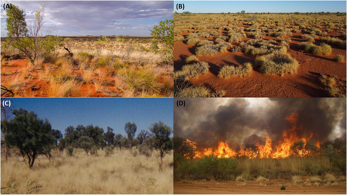
Figure 1. (A) Regenerating Triodia epactia grassland in central Gibson Desert during average rainfall conditions in 2015. (B) Long-unburnt Triodia basedowii-dominated grassland in eastern Gibson Desert during average rainfall conditions in 2017. (C) Early post-fire seral spinifex vegetation in Haasts Bluff Aboriginal Land Trust in far-eastern Western Desert during well-above average rainfall conditions in 2002. Aristida holathera is the main ground layer biomass component. (D) Lightning-ignited fire in Triodia pungens-dominated grassland on Deep Well station, central Australia. This fire occurred in November 2012 when widespread spinifex fuel accumulations occurred following exceptionally high rainfall years in 2010–2011. Triodia flowering culms double the height of the ground fuel layer.
There is little doubt that in many regions, prior to European contact, skilled and purposeful burning by Aboriginal peoples maintained landscape mosaics comprised of fire scars of different post-fire ages. These fires were crucial for human survival in spinifex grasslands, as a means of increasing hunting capture rates and promoting the growth of food plants (O’Connell et al., 1983; Bird et al., 2008; Latz, 2018). Nevertheless, several lines of evidence suggest that big spinifex grassland fires did occur during the pre-contact period:
1. Anecdotal reports from formerly “traditional-living” Aboriginal peoples of large fires occurring when traditional patch burning was being practiced. These reports come from the spinifex-dominated Gibson and Great Sandy Deserts and include mention of fires that would “go for five nights” or that could be followed for “up to a few days” and of very large wildfires that “finish ‘im up everything, right up ….” (Mutitjulu community and Baker, 1996; Yates and Morse, 2003; Burrows et al., 2006a). Such fires are reported to have forced people to abandon large areas for a time, as game and plant foods became scarce as burnt regions recovered (Yates and Morse, 2003).
2. Contemporary observations of large fires in recently burnt spinifex grassland subject to high post-fire rainfall (i.e., two large fires with an inter-fire interval of c. 2–3 years) (Latz, 1990, 2007; Gill, 2000; Allan and Southgate, 2002; Allan et al., 2003; Matthews, 2005; Wright, 2007; Wright and Clarke, 2007; Duguid et al., 2008). These observations reflect that post-fire seral state spinifex, which is usually dominated by highly flammable non-spinifex tussock grasses such as Aristida holathera Domin. (Figure 1C), can accumulate fuels quickly under high rain conditions and burn as readily, albeit at lower intensity, as old growth spinifex (see Table 1 for list of common seral spinifex species).
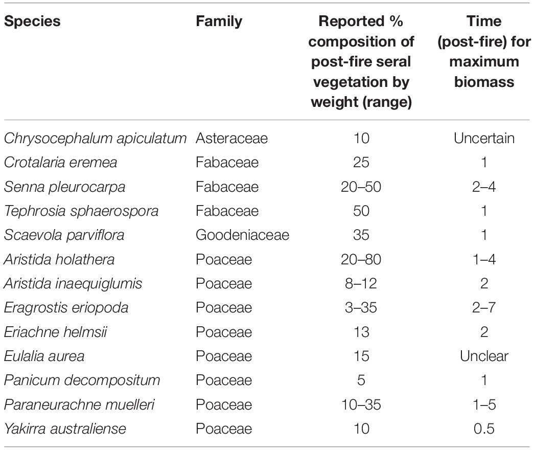
Table 1. Common seral spinifex species by % composition by weight and time-since-fire for maximum biomass levels according to Latz (1990) and TERN (2019).
3. Incursions of large spinifex wildfires into central Australian conservation reserves where patch-burn fire management has been practiced. In these reserves, good rainfall seasons in 1983–1984, 2000–2002, and 2010–2011 led to massive fuel accumulations and subsequent wildfires that either burnt over the top of previously instated patch mosaics or trickled around the patch burns and burnt large areas (Allan and Baker, 1990; Allan et al., 2003; Duguid et al., 2008; Horn and Liston, 2013).
Given the broad-scale nature of prescribed management burning in Australian spinifex grassland reserves, further assessment of the efficacy of patch burning to constrain large-scale wildfires during periods of climatic extreme is warranted. Here, we examined the records of arid Australian explorers, anthropologist’s reports, and remotely sensed data for evidence of a “rainfall–fire size” relationship in spinifex grasslands during the pre-contact period when traditional Aboriginal burning was being practiced. We restricted our search to the Western Desert, as the vegetation of this region is primarily spinifex grassland and several expeditions passed through it when traditional Aboriginal patch burning was still occurring. To ascertain the likely seasonal conditions associated with each of the expeditions, we examined (1) El Niño Southern Oscillation (ENSO) patterns derived from Oceanic Niño Index (ONI) data and (2) precipitation records from the late 1860s to present from long-term weather stations located on the periphery of the arid zone in southern South Australia (Orroroo), southwestern NSW (Wentworth), and central QLD (Springsure). ENSO conditions are usually associated with continental-scale fluctuations in rainfall variability and are known to be primary drivers of interannual variability of fire weather (Harris and Lucas, 2019). Rainfall data from the various weather stations, although spatially distant from the Western Desert, were also considered useful, as extreme-high-rainfall activity in the Australian arid and semiarid zones is often experienced at the continental scale (Denniston et al., 2015).
During our literature search, we encountered several Western Desert mythologies that mention large-scale wildfires. As indigenous oral traditions can sometimes corroborate historic events (Nunn and Reid, 2015), we provide a very brief description of these fire myths in our “Results” section and outline the massive scale of the fires that are mentioned. Additionally, as a final exercise, we conducted a satellite imagery study from a spinifex-dominated region in the southwest of the Northern Territory where large areas (c. 500,000 ha) were reported of have burnt twice in 2 years in the early 1980s following successive years of high rainfall (Allan and Southgate, 2002). Doing this exercise would demonstrate unequivocally whether recently burnt patches of spinifex grassland can re-burn rapidly if high post-fire rainfalls occur. This, by corollary, would provide an examination of the tenet of the PBM hypotheses that a relationship exists between fuel age and flammability in the spinifex system.
Materials and Methods
Study Area—The Western Desert
The study area was the Western Desert, a large arid plateau occurring primarily in the Western Australian interior and extending into the far northwest of South Australia and the southwest corner of the Northern Territory. It covers an area of approximately 800,000 km2 and encompasses the Gibson, the Great Victoria, the Great Sandy, and the Little Sandy Deserts. Geographically, the Desert is composed primarily of large sections of arid dunefield and sandplain interspersed with occasional salt lakes, clay pans, and mountain ranges. Climatically, its summers are hot, with mean maximum temperatures during the hottest month (January) reaching the mid-high 30s. Winters are cool, with mean maximum temperatures in the coolest month (July) rarely rising above 20°C. Typical of other arid Australian regions, rainfall is unpredictable, with some years receiving little or (rarely) no precipitation and others experiencing monsoon-linked deluges. Annual average rainfall ranges from 180 mm in the southeast of the Desert (Cook BOM station, SA) to 360 mm in the northwest (Telfer Aero BOM weather station) (Australian Government Bureau of Meteorology, 2021).
Study Community—Arid Spinifex Grasslands
Triodia is a large genus of perennial hummock-forming grasses that dominate grassland and savannah-type systems over approximately 26.6% of the Australian continent (AUSLIG, 1990). As aridity generally limits fuel quantity and fuel continuity in these systems, large fires usually only occur after sufficient rainfall has occurred to promote lateral expansion of hummocks and growth of interstitial species (Allan and Southgate, 2002; Armstrong, 2011). Spinifex species themselves are coarse, occasionally resinous, and sometimes form rings as plants age and die out in the center. Tall flowering culms are highly flammable when dry and can raise the fuel heights of plants to 1.5 m (Jessop, 1981). Fuel loads in long-unburnt grassland range from 1.6 to >12 tons ha–1, depending on fuel age and whether the fuel array consists purely of Triodia spp. or includes woody species (Winkworth, 1967; Beadle, 1981; Burrows et al., 2006b).
The vegetation of recently burnt spinifex grassland is quite different to that of long-unburnt grassland. In regions dominated by obligate-seeding Triodia, fire kills adult plants, and post-fire rainfall triggers the proliferation of spinifex seedlings, non-spinifex grasses, forbs, and shrub and tree seedlings (Table 1; Latz, 1990; Wright and Clarke, 2007; TERN, 2019). This successional pattern reflects release from competition after adult spinifex death, with smaller-statured non-spinifex species taking advantage of increased light, nutrient, and water availability in the post-fire environment (Griffin, 1990). Non-spinifex species usually make up the bulk of early post-fire fuels in seeder-dominated grassland, with maximum biomass of these species generally peaking within 2–3 years post-fire. Spinifex seedlings may also contribute to the early post-fire fuel array (up to 50% of the fuel biomass under certain circumstances; Latz, 1990). However, the proportion of post-fire fuels comprised by spinifex seedlings is variable and depends on several factors, including (1) post-fire rainfall season and volume; (2) the species of spinifex involved; and (3) whether mature Triodia populations had masted recently prior to fire (masting “tops up” seed banks and maximizes seed availability for post-fire spinifex seedling recruitment) (Wright and Fensham, 2018). In spinifex grasslands dominated by resprouting Triodia, early post-fire successional states are generally dominated by vegetatively regenerating spinifex hummocks rather than by short-lived non-spinifex grasses and forbs (Latz, 1990).
Estimating Fire Sizes
We located numerous explorer’s observations that allowed empiric estimation of pre-contact fire sizes in the Western Desert (Table 2 and Figure 2). Where possible, the approximate localities of the fires were identified. We followed the method used by Gill (2000) to produce a “conservative” estimate and a “less-conservative” estimate of fire size based on estimates of distances traveled over burnt ground. Conservative fire size estimates were calculated by taking the length of traverse over burnt country as the length of an elliptical fire with a length:breadth ratio of 2:1. The rationale for the use of ellipses here was that, in linear dunefield environments such as those in the Western Desert, fires frequently burn within dune valleys and are often stopped by high dune crests that act as fire breaks. This, in combination with windy conditions, often results in burn scars that are elliptical in shape. For each fire, a “less conservative” estimate of fire size was made by taking the reported length of traverse over burnt country as the diameter of a circular fire.
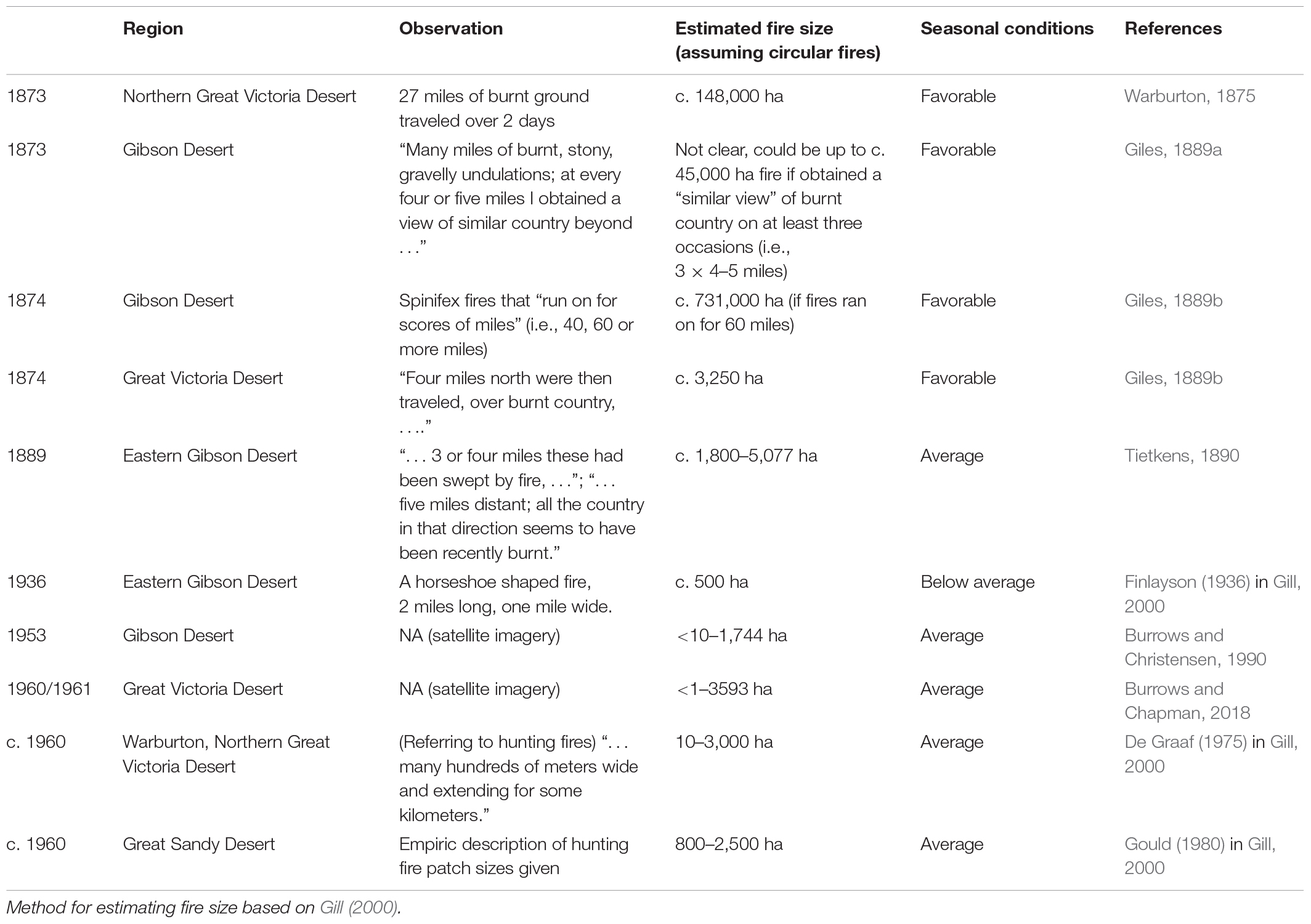
Table 2. Summary of observations of pre-contact fire sizes in Western Desert.
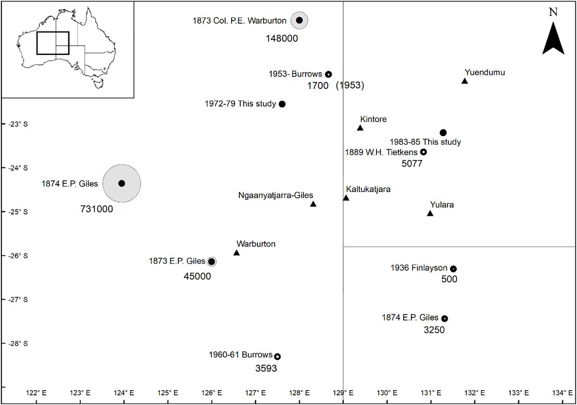
Figure 2. Map showing approximate locations of explorer’s observations of pre-contact fires in Western Desert. Circle size corresponds to relative fire sizes. Numbers associated with circles indicate estimated fire sizes (ha). Where observations give a range of fire sizes, the larger fire size is presented. Gray lines indicate Australian state and territory boundaries (South Australia, Western Australia, and Northern Territory). Triangles indicate large contemporary settlements and weather stations.
As part of our review of pre-contact Western Desert fires, we examined fire scars on Landsat satellite imagery taken during the 1970s in the Lake Mackay region of Western Australia. In this region, the last group of never-before-contacted Aboriginal people (referred to in contemporary media as the “Pintupi Nine”) had been conducting traditional burning and living a hunter-gatherer lifestyle until 1984 (Guilliatt, 2010). In the mid-1970s, one of the largest rainfall systems in history passed over northern Australia (Denniston et al., 2015; Figure 2 and online appendices 1, 2). We were interested to examine whether there was evidence of a shift in fire scar patterning in the region where the Pintupi Nine people had been burning before and after this high-rainfall period occurred. For this study, we examined imagery from 1972, a time of average to slightly above-average rainfall, and from 1979, which was when the next imagery was available after the mid-1970s rains. We mapped the fire scars for this study using Landsat 1 and 3 satellite images (WRS paths 113 and 114 and WRS rows 75 and 76; i.e., four scenes in total for each of the two time periods), and the satellite data were accessed from the USGS Earth Explorer (available at https://earthexplorer.usgs.gov/). The scenes were displayed with bands 3, 4, and 2 as red, green, and blue, respectively, to enhance the discrimination of fire scars. The 1979 scars were mapped in ArcGIS manually by drawing polygons around fire scars from a difference image created using imagery from 1972 and 1979. All scars on the 1972 image were mapped since no difference image could be created, as there was no previous Landsat image. The extent of the fires went well beyond the four chosen Landsat scenes. However, we limited the mapping to the extent of the four mentioned scenes.
For the early 1980s “short-interval fire mapping” study, we used Landsat 4 and 5 imagery (WRS paths 104 and 105 and rows 76 and 77) downloaded from the USGS Earth Explorer (available at https://earthexplorer.usgs.gov/). Scenes from 1982 were compared with those from 1983 (an interval of about 6 months) to create a difference image. The scars of the fires were digitized in ArcGIS. The same methodology was repeated for the fires over the summer of 1984–1985. The fire scars of interest were all completely contained within the examined Landsat scenes.
Results
Pre-contact Fire
Several observations were made by explorers that indicate that large fires were occurring during the pre-contact period in the Western Desert. These observations were made in the early-mid 1870s during expeditions led by Col. P. Egerton-Warburton (hereafter referred to as Col. Warburton) and W.E.P. (Ernest) Giles (Table 2 and Figure 2). From the long-term weather data, seasonal conditions during these expeditions appear to have been highly favorable. The ONI for 1870 was −1.0 or lower across all weather stations, suggesting that La Niña conditions prevailed and that higher-than-average rainfall would have occurred across much of northern and central Australia during the summer of 1870/1871 (Figure 3). Rainfall records of Springsure, Wentworth, and Ororroo weather stations provide further evidence that a continental-scale extreme wet period had occurred at this time (Figure 3 and Supplementary Appendix Figures 1, 2). All stations showed extreme-high-rainfall years in the early 1870s, with 1870 being the highest rainfall year on record for the Wentworth and Orroroo weather stations and the fifth highest rainfall year on record for Springsure (Australian Government Bureau of Meteorology, 2021).

Figure 3. Twenty-four-month cumulative rainfall and rainfall anomaly data from Wentworth weather station in southwest NSW. Bottom panel shows Oceanic Niño Index (ONI) 3.4 from 1870 to present. Major rainfall events/periods associated with big arid zone wildfires are shown in gray bands.
Both Giles and Col. Warburton mentioned large-scale fires during their expeditions. While traveling through the Mt Wilson region of Western Australia in 1873, Col. Warburton traveled over 27 miles (43.5 km) of burnt ground over 2 days. This suggests a minimum fire size of c. 58,000 ha (assuming an elliptical fire with a 2:1 length:breadth ratio) and a maximum fire size of c. 148,000 ha (assuming a circular fire). Giles, while traveling through the southern Gibson Desert in 1876, estimated that under high-wind conditions, fires in spinifex habitat could “run on for scores of miles,” implying that he had observed fires that had burnt for distances of at least 40 miles (64 km) but possibly up to 60 miles (96 km) or more. If the fires he had witnessed had been 40 miles in cross section, then burnt areas could have been between 163,000 (assuming elliptical fires) and 325,000 ha (assuming fires were circular). If the fires had run for three score miles (96 km), then areas burnt could have been between 366,000 ha (if elliptical fires) and 731,000 ha (if circular fires).
There were several observations of smaller fires (<1 to c. 5000 ha) during unexceptional rainfall years in the late nineteenth and early- to mid-twentieth centuries. These include observations made by Tietkins, Finlayson, Burrows and Christenson, De Graaf, and Gould (Table 2 and Figure 2). From our remote sensing study of the Lake Mackay region, numerous smaller fires were observed on the 1972 imagery, which may have been, at least partially, the result of traditional burning conducted by the Pintupi Nine (Figure 4). These small-scale fires were obliterated in the 1979 imagery, which showed c. 7.17 million ha (i.e., 66%) of the mapped area burnt. These large-scale fires presumably occurred in response to fuel accumulations after the record-breaking rains of 1974/1975. It could be argued that these 1970s fire observations are irrelevant to the PBM hypothesis, as low population size would have limited the spatial extent of patch burning by the Pintupi Nine. By this time, other traditional-living Aboriginal peoples in the region had come out of the desert and were settled in communities such as Haasts Bluff, Papunya, and Balgo (Hansen, 1984; Heffernan, 1984). However, population densities in the extreme-low productivity Gibson Desert were always low, traditionally in the order of 1 person per 200 - 260 km2 (Long, 1971), so the images may still be relevant.
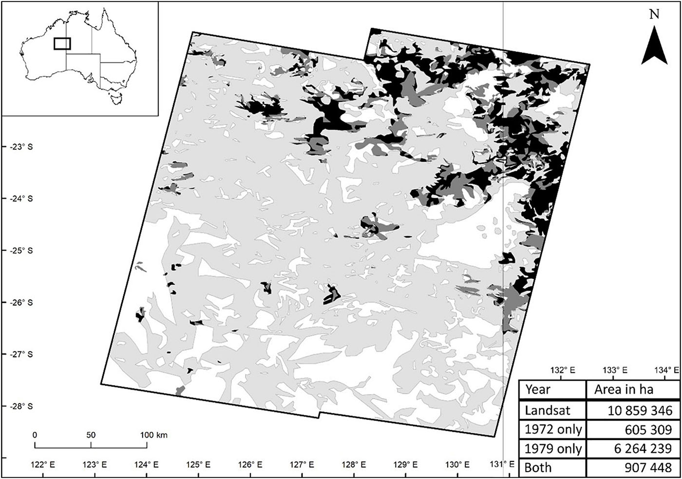
Figure 4. 1970s fire scars from homelands of the Pintupi Nine, west of Lake Mackay in the Gibson Desert, Western Australia. Fires in light gray were evident on 1979 satellite imagery and are presumed to have occurred in response to fuel accumulations after high rainfall years of 1974/1975. Fires in black were burnt twice (1972 and 1979), and areas in dark gray were burnt in 1972 only. White areas were unburnt throughout study period.
Aboriginal Fire Myths
Several Western Desert myths were identified that mentioned extreme-large scale fires. In the Warlukurlangu myth (Kimber, 1983), a large blaze ignited by the lungkata (blue tongue) ancestral spirit began in Warlpiri tribal country close to present-day Yuendumu community and burnt in a southward direction to Pitjantjatjara country, some 400-km distant. The minimum dimensions of this fire, if circular, would have been c. 12.6 million ha, and if an ellipse with a 2:1 length:breadth ratio, would have been c. 6.3 million ha. In another myth, from the arid Lake Mackay region of Western Australia, a large fire that ignited close to the edge of Lake Mackay forced an ancestral being to flee underground to Nyinmi rock hole, some 150 km to the southwest (Tjupurrula, 2014). If this fire had burnt all the way to Nyinmi, then the approximate dimensions of this fire would have been c. 1.8 million ha if circular and c. 0.9 million ha if an ellipse with a 2:1 length:breadth ratio.
There are also several mythologies from arid regions outside the Western Desert that report large spinifex fires. These include the “Ahiite” myth, where a large fire begins in Alyawarra country on the Sandover River and burns across 350 km in a southwest direction to Rubuntja, a fire dreaming site of the Aranda tribe in the western MacDonnell ranges (Moyle and Morton, 1986; Memmott, 1992). There is also an Alyawarra “traveling fire dreaming,” which concerns a fire that begins near the Plenty river in the southern Northern territory and burns across c. 400 km of the Triodia dominated Wakaya Desert to the Table Top region in western Queensland, c. 40 km southwest of Camooweal (Keys and Memmott, 2016; Memmott, P. pers. Comm. 2021).
1980s Short-Interval Fires
Our mapping of the 1980s short interval fires from the southwest Northern Territory confirmed the report of Allan and Southgate (2002) that large areas of spinifex grassland had re-burnt in this region only 2 years after initial fires had occurred. The mapping showed that fires in late 1982/early 1983 burnt c. 1.95 million ha. These fires presumably occurred in response to rainfall-triggered fuel accumulations after exceptionally high rains in 1981–1982 (Figure 5). During this time, the Derwent meteorological station in the far NE of study area indicates 932-mm rainfall fell in the 18-m period prior to April 1982 (the Derwent has an annual average precipitation of 327 mm) (Supplementary Appendix Figure 4; Australian Government Bureau of Meteorology, 2021). Approximately 2 years later, large fires in late 1984 burnt c. 1 million ha in the region, with c. 470,000 ha burning over areas that had already burnt in 1982/1983. These follow-up fires presumably occurred in response to fuel accumulations triggered by continued exceptionally high rainfall in 1983 and early 1984 (Figure 5 and Supplementary Appendix 3). During this time, the Derwent rainfall records indicate that 719-mm rainfall fell during the 18-month period prior to April 1984 (Supplementary Appendix Figure 4; Australian Government Bureau of Meteorology, 2021).
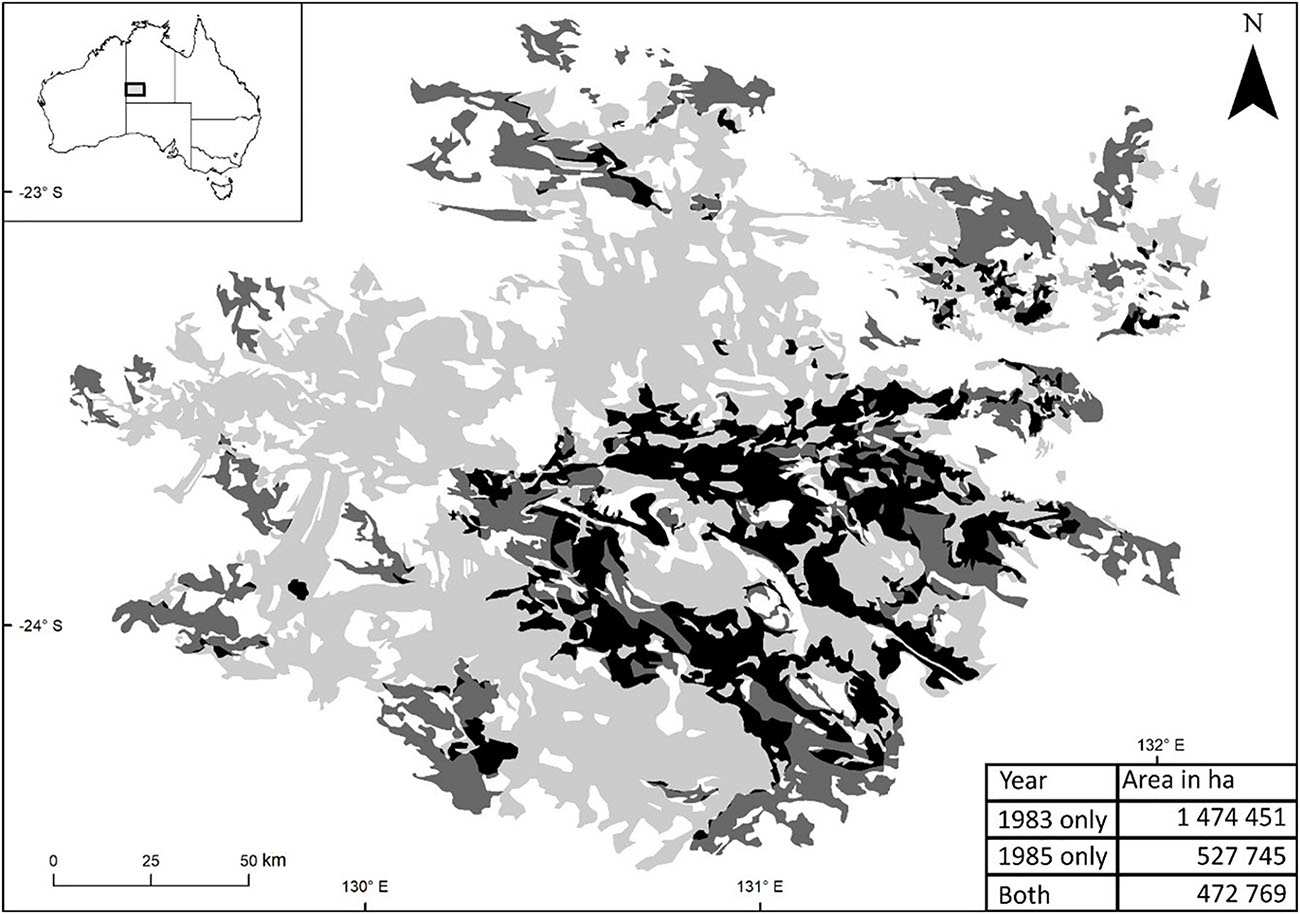
Figure 5. Large-scale short-interval wildfires in west central Australia in the early 1980s. Patches in light gray show the extent of a single fire that occurred in 1982/1983. Patches that are dark gray burnt in 1984/1985 and patches that are black burnt in both periods. White areas within the 1982/1983 fire were unburnt throughout the study period. Rainfall during the study period at “The Derwent” weather station is given in Supplementary Appendix 4.
Discussion
Pre-contact Fire Sizes
The fires identified by Col. Warburton in 1873, Giles in 1873 and 1874, and the 1970s Lake Mackay mapping of this study are examples of massive rainfall-linked fires during the pre-European period when traditional Aboriginal patch burning was still being practiced. The size of these fires is similar in scale to larger arid Australian wildfires recorded following high-rainfall periods in the contemporary era (Griffin et al., 1983; Allan and Southgate, 2002; Allan et al., 2003; Verhoeven et al., 2020) and dwarfs modern fires observed during periods of average or below-average rainfall (Turner et al., 2008). Observations of large pre-contact fires directly contradict one of the central tenets of the PBM hypothesis—that indigenous patch burning should constrain large wildfires by fragmenting landscapes and breaking up fuel loads (Minnich, 1983, 1998). They are, however, consistent with paleoecological (dendrochronological) records from the United States that indicate episodic large-scale fires were a prominent feature in certain American pre-contact landscapes, despite frequent burning by indigenous people (Mensing et al., 1999).
Additional evidence that large-scale spinifex fires occurred during the pre-European period may come from Western Desert Aboriginal fire mythologies. Previous authors have suggested that indigenous oral traditions can corroborate real events from the temporally distant past (i.e., euhemerism) (Vitaliano, 1973; Barber and Barber, 2004). Nunn and Reid (2015) have argued that because Australian Aboriginal cultural protocols place great importance on traditional knowledge, precise transgenerational transmission of oral traditions can occur over exceptionally long time periods. Extremely large wildfires in several Western Desert Aboriginal mythologies could therefore derive from real fires from the ancient pre-contact period. The scale of the fires mentioned in the myths is massive and, if they were actual fires, would have left large tracts of country uninhabitable for a period and presumably left long-lasting impressions on Aboriginal peoples living in the burnt regions.
A highly referenced series of pre-contact Aboriginal fire scars from the Western Desert are those captured by the 1953 Blue Streak and 1960/1961 aerial photography (Burrows and Chapman, 2018; Clark, 2020). These fire observations have been held as strong evidence that the pre-contact fire regime of the Western Desert was characterized by patchy, small-scale, cool-season fires and that large summer fires in the contemporary era are anomalous. However, to properly determine if traditional burning constrained large rainfall-linked fires would require assessing imagery taken at a time of known high rainfall when widespread fuel accumulations would have been present. Although some parts of Australia were very wet in the early 1950s, especially western Queensland (see Springsure data—Supplementary Appendix Figure 2), weather records are available for the early 1950s from the Giles Metrological and Warburton weather stations. Both stations are within c. 150 km of the areas captured in the Blue Streak and 1960/1961 aerial photography, and both indicate only average to slightly below-average rainfall conditions during the years immediately prior to the time the photos were taken (Australian Government Bureau of Meteorology, 2021; Supplementary Appendix 4).
Short-Interval Spinifex Fires
Our mapping of large, short-interval fires during a high-rainfall period in the Western Desert in the 1980s demonstrates unequivocally that the effectiveness of recently burnt areas to act as fire breaks can degenerate rapidly when rainfall conditions are good. Such observations of rainfall-triggered short-interval (2–3 years) fires in spinifex grasslands are not unique, with numerous other studies/authors having reported short-interval spinifex grassland fires on Aboriginal lands (Allan and Southgate, 2002; Wright, 2007), pastoral properties (Latz, 1990; Allan and Southgate, 2002), and fire-managed arid conservation reserves such as Uluru Kata-Tjuta (Ayer’s Rock) National Park (Allan et al., 2003) and Finke Gorge National Park (Matthews, 2005).
The mechanism that allows post-fire seral spinifex to return to a flammable state quickly after high rainfall is rapid growth rates of highly flammable non-spinifex grass and forb species (Latz, 1990; Allan and Southgate, 2002). The C4 tussock grass, kerosene grass (Aristida holathera), is one of the most important contributors by weight in seral spinifex vegetation, comprising up to 80% of vegetation biomass in the first 2 years after fire (Figure 1C and Table 1; Griffin et al., 1983; Latz, 1990; TERN, 2019). This grass species has seeds that are triggered to germinate by smoke (Wright, 2007; Wright and Clarke, 2009), and although generally an annual, it can behave as a perennial following successive good rainfall seasons that permit continued growth (Latz, 1990). Fires fueled primarily by A. holathera are fast burning (hence the common name “kerosene grass”), though the fuel loads of Aristida-fueled fires (c. 0.5 kg m–2) are lower than Triodia-fueled fires (c. 1.55 kg m–2) (Wright and Clarke, 2008) and hence generally burn at a lower intensity.
The Evolutionary Fire Regime of Arid Spinifex Grasslands
An obvious corollary to the suggestion that large rainfall-linked spinifex grassland fires occurred during the pre-European period is that such fires also occurred during the period prior to human arrival in arid Australia, some 30–40 ka years BP (Smith, 2013). If this was the case, then large rainfall-linked megafires must be considered a feature of the “evolutionary” arid spinifex fire regime, and some signal of an adaptive influence of the fire–rainfall relationship on arid zone fauna and flora might be expected. Some authors have argued that extinctions in the modern era of many small-medium sized animals are evidence that large contemporary wildfires are aberrant and that the fauna have not adapted to them (Masters, 1993). However, recent research indicates that it is an interaction between large fires and introduced predators that has led to these extinctions, with native animals unable to cope with increased predation risk under more open habitat conditions following large-scale wildfires (Letnic and Dickman, 2006).
One possibility of an adaptive trait that relates to the arid fire–rainfall relationship is the rainfall-linked mast seeding syndromes of arid Triodia grasses and slender mulga (Acacia aptaneura Maslin and J. E. Reid) shrubs (Jacobs, 1973; Davies and Kenny, 2013; Wright et al., 2014; Wright and Fensham, 2017). Contrary to popular perception, many spinifex species rarely set seed, instead producing prodigious amounts of reproductive stems/culms that hold little or no seed in most years, and only producing large crops after exceptionally high preceding rainfall (masting) (Jacobs, 1984; Rice et al., 1994; Armstrong and Legge, 2011). As seed predation prevents large quantities of spinifex seed being stored in the soil seed bank, it would be a risky strategy to produce seed annually in arid environments with highly unpredictable rainfall. Such a strategy would also preclude obligate seeders being able to survive under a regular fire regime that was not synchronized to weather patterns, such as under the proposed PBM hypothesis. In the case of arid Triodia and mulga, seeding “in-synch” with arid rain–fire cycles may have been selected for because it ensures high seed-bank densities during periods when fire likelihood is high. This in turn maximizes the likelihood of dense seedling recruitment in favorable post-fire environments that are low in competition and high in moisture and nutrient availability (Wright et al., 2014; Wright and Fensham, 2018).
Patch Burning in Spinifex Grassland Reserves
Although evidence presented in this paper casts doubt on the efficacy of spinifex patch burning for preventing large rainfall-linked fires, there is no doubt that small-scale managed fires are useful in spinifex conservation reserves for a variety of other reasons. Burning increases the productivity of spinifex habitat by stimulating the germination and growth of a variety of non-spinifex plant species that are useful as food for both humans and animals. Such plants include grain-producing grass species such as Eragrostis eriopoda Benth. and Yakirra australiensis Lazarides R. D. Webster and fruit-producing plants such as Solanum centrale J. M. Black, Solanum cheppendalei Symon, and Solanum cleistogamum Symon (O’Connell et al., 1983; Southgate and Carthew, 2007; Latz, 2018). In parts of the Gibson Desert, spinifex burning is also used by Aboriginal peoples to enhance collection rates of seeds of serotinous species with woody fruits that only release seeds after fire (e.g., Eucalyptus pachyphylla F. Muell.) (Nangala et al., 2019).
Patch-burning spinifex may also be useful for reducing the likelihood of large rainfall-linked wildfires entering fire-sensitive communities like Aluta maisonneuvei (F. Muell.) Rye and Trudgen shrublands or mulga woodlands (Gill, 2000; Wright, 2018). Patch burning for this purpose would have to occur after rainfall-triggered fuel accumulations have already occurred (to prevent patches from re-burning) and would have to be targeted around the edges of the fire-sensitive communities. The breaks would have to be burnt under low-wind/low temperature conditions to prevent fire from escaping. They would also have to be extensive in terms of spatial coverage and wide enough to prevent fire spread into the sensitive communities in the event of wildfire. Under such a management scenario, the likelihood of fire incursion into fire-sensitive vegetation should be minimized, and this should safeguard against population declines caused by repeated fires at intervals less than the Aluta and mulga primary juvenile periods.
A limitation of the current study is that no detail about the patchiness of pre-contact spinifex grassland megafires can be gleaned from the explorers’ records. It is possible that megafires under traditional burning regimes were patchier and had greater retention of unburnt vegetation than contemporary Triodia-fueled wildfires. It is also possible that Aboriginal burning mitigated the ecological impacts of rainfall-linked megafires as recently burnt short grass-dominated patches would have burnt at lower intensities during megafires than mature Triodia-dominated vegetation. Nevertheless, as has been observed in contemporary arid zone reserves, patch burning in spinifex grasslands can lead to increased fire frequency (Allan et al., 2003; Matthews, 2005). In the absence of patch burning, arid spinifex grasslands normally only burn after high rainfall times when fuel loads are high. If patch burning takes place during average rainfall (i.e., low fuel load) years, then spinifex systems may be exposed to patch burning in these years as well as large-scale wildfires that inevitably occur following extreme-high-rainfall (i.e., high fuel load) years. At present, the state of ecological research in arid spinifex grasslands does not permit discernment of which scenario, multiple low-intensity fires, or a single high-intensity rainfall-linked megafire, is less destructive from an ecological standpoint. However, it is quite possible that the biota is resilient to a range of burning scenarios.
Conclusion
The PBM hypothesis was first applied in arid Australia as a means of duplicating traditional Aboriginal burning practices in desert conservation reserves (Saxon, 1984). Its implementation was intended to promote diversity in flora and fauna habitats and to constrain large-scale wildfires by reducing fuel loads. We do not dispute that pre-European burning by Aboriginal peoples was widespread and enabled human habitation in spinifex grasslands by increasing plant and animal food resources. However, evidence presented in this paper suggests that occasional large-scale wildfires are an innate feature of arid spinifex grasslands, and that PBMs can become redundant following extreme-high-rainfall periods that trigger fuel accumulation. The rainfall–fire link in arid spinifex grasslands parallels the climate–fire linkage in sclerophyll Eucalypt-dominated forests of temperate Australia. In these forests, periodic droughts dry out fuels and, when combined with extreme fire weather, can trigger extreme-high-intensity megafires even in regions that are fire-managed for fuel reduction (Deb et al., 2020; Ehsani et al., 2020; Bowman et al., 2021). Further research is warranted to identify other Australian vegetation types where patch-burn mosaics are unlikely to constrain megafires under extreme climatic conditions. Given the apparent inevitability of wildfires following exceptionally good seasons in arid spinifex grasslands, judicious use of scarce land management funds should focus on (1) ensuring strategic placement of infrastructure; (2) reducing anthropogenic ignitions during periods of elevated flammability; and (3) facilitation of fire-related research to assess effects of fire on the spinifex biota.
Data Availability Statement
The raw data supporting the conclusions of this article will be made available by the authors, without undue reservation.
Author Contributions
BW, RF, GA, and BL conceived and designed the research. BW conducted the literature search. DR analyzed the climate data and produced the rainfall figures. BL conducted the fire mapping. BW, GA, RF, DR, and BL wrote the manuscript. All authors contributed to the article and approved the submitted version.
Conflict of Interest
The authors declare that the research was conducted in the absence of any commercial or financial relationships that could be construed as a potential conflict of interest.
Acknowledgments
We thank the following people for providing important discussions on spinifex grassland fire regimes: Steve Morton, Alan Anderson, Todd Elliott, Bob Wright, Wal Whalley, Malcolm Gill, Robert Mengler, Grant Allan, Andrew Burbidge, Jen Silcock, Dennis Mathews, Mike Smith, Paul Memmott, Peter Bridge, Alex George, Paul Sweeney, Richard Kimber, Margaret Friedel, and Emrys Leitch.
Supplementary Material
The Supplementary Material for this article can be found online at: https://www.frontiersin.org/articles/10.3389/fevo.2021.666241/full#supplementary-material
References
Allan, G., and Baker, L. (1990) Uluru (Ayers Rock-Mount Olga) National Park: an assessment of a fire management program. Pro. Ecol. Soc. Austral. 16, 215–220.
Allan, G. E., Phillips, N. R., and Hookey, P. (2003). “Learning lessons from an exceptional period of fires in central Australia: 1999 to 2002,” in Proceedings of the 3rd International Wildland fire Conference, Sydney, NSW.
Allan, G. E., and Southgate, R. (2002). “Fire regimes in the spinifex grasslands of Australia,” in Flammable Australia: Fire Regimes and Biodiversity of a Continent, eds R. A. Bradstock, J. E. Williams, and A. M. Gill (Cambridge: Cambridge University Press), 145–176.
Armstrong, G. (2011). Evidence for the equal resilience of Triodia spp. (Poaceae), from different functional groups, to frequent fire dating back to the late Pleistocene. Heredity 107, 558–564. doi: 10.1038/hdy.2011.42
Armstrong, G., and Legge, S. (2011). The post-fire response of an obligate seeding Triodia species (Poaceae) in the fire-prone Kimberley, north-west Australia. Int. J. Wildland Fire 20, 974–981. doi: 10.1071/wf10130
AUSLIG (1990). Vegetation. Atlas of Australian Resources. Third Series, Vol. 6. Canberra, NSW: AUSLIG.
Australian Government Bureau of Meteorology (2021). Monthly Rainfall Totals from Warburton Airfield, Giles Meteorological Station, Springsure, Wentworth, Orroroo, Cook, Telfer. Docklands, VIC: Australian Government Bureau of Meteorology.
Barber, E. W., and Barber, P. T. (2004). When They Severed Earth from Sky: How the Human Mind Shapes Myth. Princeton, NJ: Princeton University Press.
Bird, R. B., Bird, D. W., Codding, B. F., Parker, C. H., and Jones, J. H. (2008). The “fire stick farming” hypothesis: Australian Aboriginal foraging strategies, biodiversity, and anthropogenic fire mosaics. Proc. Natl. Acad. Sci. U.S.A. 105, 14796–14801. doi: 10.1073/pnas.0804757105
Bliege Bird, R., Codding, B. F., Kauhanen, P. G., and Bird, D. W. (2012). Aboriginal hunting buffers climate-driven fire-size variability in Australia’s spinifex grasslands. Proc. Natl. Acad. Sci. U.S.A. 109, 10287–10292. doi: 10.1073/pnas.1204585109
Bonnicksen, T. M. (1981). Brushland fire-management policies: a crossimpact simulation of southern California. Environ. Manag. 5, 521–529. doi: 10.1007/bf01866725
Bowman, D., Williamson, G. J., Price, O. F., Ndalila, M. N., and Bradstock, R. A. (2021). Australian forests, megafires and the risk of dwindling carbon stocks. Plant Cell Environ. 44, 347–355. doi: 10.1111/pce.13916
Bradstock, R. A. (2010). A biogeographic model of fire regimes in Australia: current and future implications. Glob. Ecol. Biogeogr. 19, 145–158. doi: 10.1111/j.1466-8238.2009.00512.x
Burrows, N., and Chapman, J. (2018). Traditional and Contemporary Fire Patterns in the Great Victoria Desert, Western Australia. Final Report, Great Victoria Desert Biodiversity Trust Project GVD-P-17-002. Perth, WA: Biodiversity and Conservation Science Division, Department of Biodiversity, Conservation and Attractions.
Burrows, N. D., Burbidge, A. A., Fuller, P. J., and Behn, G. (2006a). Evidnce of altererd fire regimes in the Western DEsert region of Australia. Conserv. Sci. 5, 272–284.
Burrows, N. D., and Christensen, P. E. S. (1990). “A survey of Aboriginal fire patterns in the Western Desert of Australia,” in Fire and the Environment: Ecological and Cultural Perspectives: General Technical Report SE-69, Southeastern Forest Experimental Station, eds S. C. Nodvin and T. A. Waldrop (Asheville, NC: U.S. Department of Agriculture Forest Service).
Burrows, N. D., Ward, B., and Robinson, A. (1991). Fire behaviour in Spinifex fuels in the Gibson Desert Nature Reserve. Journal of Arid Environments 20, 189–204. doi: 10.1016/s0140-1963(18)30708-0
Burrows, N. D., Ward, B., Robinson, A. D., and Behn, G. (2006b). “Fuel dynamics and fire behaviour in spinifex grasslands of the Western Desert,” in Proceedings of the Bushfire Conference 2006 Life in a Fire-Prone Environment: Translating Science into Practice, (Brisbane QLD).
Clark, C. (2020). Causes of big bushfires in Australia: higher temperatures and rainfall or more fuel? J. Geosci. Environ. Protection 8, 79–94. doi: 10.4236/gep.2020.88007
Davies, S. J. J. F., and Kenny, S. A. (2013). The ages and fecundity of some arid-zone plants in Western Australia. Rangeland J. 35, 455–468. doi: 10.1071/rj12112
De Graaf, M. (1975). “The Aboriginal use of fire,” in Report on the Use of Fire in National Parks and Reserves, Darwin, Department of the Northern Territory Forestry, Fisheries, Wildlife, Environment and National Parks Branch, ed. R. E. Fox 14–19.
Deb, P., Moradkhani, H., Abbaszadeh, P., Kiem, A. S., Engstrom, J., Keellings, D., et al. (2020). Causes of the widespread 2019-2020 Australian bushfire season. Earths Future 8:e2020EF001671. doi: 10.1029/2020ef001671
Denniston, R. F., Villarini, G., Gonzales, A. N., Wyrwoll, K.-H., Polyak, V. J., Ummenhofer, C. C., et al. (2015). Extreme rainfall activity in the Australian tropics reflects changes in the El Niño/Southern Oscillation over the last two millennia. Proc. Natl. Acad. Sci. U.S.A. 112, 4576–4581.
Duguid, A., Brock, C., and Gabrys, K. (2008). “A review of fire management on central Australian conservation reserves: towards best practice,” in Desert fire: Fire and Regional Land Management Practises in the Arid Landscapes of Australia, eds G. P. Edwards and G. E. Allan (Alice Springs, NT: Desert KNowledge Cooperative Research Centre).
Ehsani, M. R., Arevalo, J., Risanto, C. B., Javadian, M., Devine, C. J., Arabzadeh, A., et al. (2020). 2019-2020 Australia fire and its relationship to hydroclimatological and vegetation variabilities. Water 12:3067. doi: 10.3390/w12113067
Gamage, B. (2012). The Biggest Estate on Earth: How Aborigines made Australia. Crows Nest, NSW: Allen & Unwin.
Giles, E. (1889a). Australia Twice Traversed: The Romance of Exploration, Vol. I. London: Sampson Low, Marsto11, Searle and Rivington.
Giles, E. (1889b). Australia Twice Traversed: The Romance of Exploration, Vol. II. London: Sampson Low, Marston, Searle and Rivington.
Gill, A. M. (2000). Fire-Pulses in the Heart of Australia: Fire Regimes and Fire Management in Central Australia. Unpublished Report to Environment Australia, August 2000.
Gill, A. M., and Allan, G. E. (2008). Large fires, fire effects and the fire-regime concept. Int. J. Wildland Fire 17, 688–695. doi: 10.1071/wf07145
Goforth, B. S., and Minnich, R. A. (2007). Evidence, exaggeration, and error in historical accounts of chaparral wildfires in California. Ecol. Appl. 17, 779–790. doi: 10.1890/06-0831
Griffin, G. F. (1990). Characteristics of three spinifex alliances in Central Australia. J. Veg. Sci. 1, 435–444. doi: 10.2307/3235776
Griffin, G. F., Price, N. F., and Portlock, H. F. (1983). Wildfires in the central Australian Rangelands, 1970-1980. J. Environ. Manag. 17, 311–323.
Guilliatt, R. (2010). Shcok of the new: whatever happened to the Pintupi nomads? Weekend Austral. Magaz.
Hansen, K. C. (1984). “Communicability of some Western Desert communilects,” in Work Papers of the SIL-AAB Series B Language Survey, Vol. 11, eds H. Joyce and N. Pym (Nakara NT: Summer Institute of Linguistics).
Harris, S., and Lucas, C. (2019). Understanding the variability of Australian fire weather between 1973 and 2017. PLoS One 14:e0222328. doi: 10.1371/journal.pone.0222328
Heffernan, J. A. (1984). Dialect Change Among the Eastern Pintupi. Papunya, NT: Papunya Literature Production Centre.
Horn, A., and Liston, G. (2013). Resort Evacuated as Fires Burn in Red Centre. ABC News. Available online at: https://www.abc.net.au/news/2013-2001-2008/red-centre-heat-records-and-fires/4456544 (accessed Jan 08, 2013).
Jacobs, S. W. L. (1973). Ecological studies on the genera Triodia R. Br. and Plectrachne Henr. in Australia. Ph.D. thesis. Camperdown NSW: University of Sydney.
Jacobs, S. W. L. (1984). “Spinifex,” in Arid Australia, eds H. G. Cogger and E. E. Cameron (Chipping Norton, NSW: Surrey Beatty & Sons Pty. Ltd.).
Keeley, J. E., and Fotheringham, C. J. (2001). Historic fire regime in southern California shrublands. Conserv. Biol. 15, 1536–1548. doi: 10.1046/j.1523-1739.2001.00097.x
Keeley, J. E., and Zedler, P. H. (2009). Large, high-intensity fire events in southern California shrublands: debunking the fine-grain age patch model. Ecol. Appl. 19, 69–94. doi: 10.1890/08-0281.1
Keys, B., and Memmott, P. (2016). Indjalandji-Dhidhanu Country, Qld; Cultural Heritage Survey Report, Northern Gas Pipeline. Prepared for Jemena (SGSP Assets Pty Ltd). Camooweal, QLD: Dugalunji Aboriginal Corporation.
Kimber, R. (1983). Black lightning: Aborigines and fire in central Australia and the Western Desert. Archaeol. Ocean. 18, 38–45. doi: 10.1002/arco.1983.18.1.38
Kimber, R. G., and Friedel, M. H. (2015). Challenging the concept of Aboriginal mosaic fire practices in the Lake Eyre basin. Rangeland J. 37, 623–630. doi: 10.1071/rj15057
Latz, P. K. (1990). Observations on the Effect of Fire on Central Australian Grassland Communities. Alice Springs, NT: Parks and Wildlife Commission of the Northern Territory.
Latz, P. K. (2007). The Flaming Desert: Arid Australia – A Fire Shaped Landscape. Alice Springs, NT: NT Print Management.
Letnic, M., and Dickman, C. R. (2006). Boom means bust: interactions between the El Nino/Southern Oscillation (ENSO), rainfall and the processes threatening mammal species in arid Australia. Biodiv. Conserv. 15, 3847–3880. doi: 10.1007/s10531-005-0601-2
Long, J. P. M. (1971). “Arid region Aborigines: the Pintubi,” in Aboriginal Man and Environment in Australia, eds D. J. Mulvaney and J. Golson (Canberra, NSW: Australian National University Press).
Masters, P. (1993). The Effects of Fire-driven succession and rainfall on small mammals in spinifex grassland at Uluru National Park. North. Territory Wildlife Res. 20, 803–813. doi: 10.1071/wr9930803
Matthews, D. (2005). Fire Management – Finke Gorge National Park, Internal Report. Alice SPrings, NT: Parks and Wildlife Service of the Northern Territory.
Memmott, P. (1992). The Registration of a Further Sixteen Alyawarre Sacred Sites and One Wakaya Site on Elkedra Station. Report for Aboriginal Area Protection Authority. Alice Springs, NT.
Mensing, S. A., Michaelsen, J., and Byrne, R. (1999). A 560-year record of Santa Ana fires reconstructed from charcoal deposited in the Santa Barbara Basin, California. Quat. Res. 51, 295–305. doi: 10.1006/qres.1999.2035
Minnich, R. A. (1983). Fire mosaics in southern California and northern Baja California. Science 219, 1287–1294. doi: 10.1126/science.219.4590.1287
Moritz, M. A., Keeley, J. E., Johnson, E. A., and Schaffner, A. A. (2004). Testing a basic assumption of shrubland fire management: how important is fuel age? Front. Ecol. Environ. 2, 67–72. doi: 10.1890/1540-92952004002[0067:TABAOS]2.0.CO;2
Moritz, M. M., Moody, T. J., Miles, L. J., Smith, M. M., and de Valpine, P. (2009). The fire frequency analysis branch of the pyrostatistics tree: sampling decisions and censoring in fire interval data. Environ. Ecol. Stat. 16, 271–289. doi: 10.1007/s10651-007-0088-y
Moyle, R., and Morton, S. (1986). Alyawarra Music: Songs and Society in a Central Australian Community. Canberra, NSW: Australian Institute of Aboriginal Studies.
Mutitjulu community¡/snm¿ and Baker, L. (1996). Minkiri. A Natural hisotry of Uluru by the Mutitjulu community. Alice Springs, NT: IAD Press.
Nangala, J., Napangardi, Y., Napangardi, Y., and Wright, B. R. (2019). Ethnobotany of Warrilyu (Eucalyptus pachyphylla F.Muell. Myrtaceae): Aboriginal seed food of the Gibson Desert, Western Australia. Econ. Bot. 73, 416–422. doi: 10.1007/s12231-019-09471-2
Nunn, P. D., and Reid, N. J. (2015). Aboriginal memories of inundation of the Australian coast dating from more than 7000 years ago. Austral. Geogr. 47, 11–47. doi: 10.1080/00049182.2015.1077539
O’Connell, J. F., Latz, P. K., and Barnett, P. (1983). Traditional and modern plant use among the Alyawara of central Australia. Econ. Bot. 37, 80–109. doi: 10.1007/bf02859310
Rice, B. L., Westoby, M., Griffin, G. F., and Friedel, M. H. (1994). Effects of supplementary nutrients on hummock grasses. Austral. J. Bot. 42, 687–703. doi: 10.1071/bt9940687
Saxon, E. C. E. (1984). Anticipating the Inevitable: A Patch-Burn Strategy for Fire Management at Uluru (Ayers Rock – Mt Olga) National Park. Melbourne, VIC: CSIRO Australia.
Smith, M. (2013). The Archaeology of Australia’s Deserts. Cambridge, MA: Cambridge University Press.
Southgate, R., and Carthew, S. (2007). Post-fire ephemerals and spinifex-fuelled fires: a decision model for bilby habitat management in the Tanami Desert, Australia. Int. J. Wildland Fire 16, 741–754. doi: 10.1071/wf06046
TERN (2019). Summary of Sites in Hummock Grasslands 2011 - 2019. Terrestrial Ecosystem Research Network.
Tietkens, W. H. (1890). Journal of Mr. W.H. Tietkens’ Central Australian Exploring Expedition. South Australian Parliamentary Papers, Vol. 111. Adelaide, SA: S.A. Government Printer, 2–32.
Tjupurrula, J. Y. (2014). Tjukurrpa Ngaatjanya Maru Kamu Tjulkura (Dreaming In Black And White) [Online]. ReDot Fine Art Gallery. Available online at: https://issuu.com/redotfineartgallery/docs/20121017_tjukurrpa_ngaatjanya_maru_ (accessed January 29, 2021).
Turner, D., Ostendorf, B., and Lewis, M. (2008). An introduction to patterns of fire in arid and semi-arid Australia, 1998–2004. Rangeland J. 30, 95–107. doi: 10.1071/rj07039
Verhoeven, E. M., Murray, B. R., Dickman, C. R., Wardle, G. M., and Greenville, A. C. (2020). Fire and rain are one: extreme rainfall events predict wildfire extent in an arid grassland. Int. J. Wildland Fire 29, 702–711. doi: 10.1071/wf19087
Vitaliano, D. (1973). Legends of the Earth: Their Geologic Origins. Bloomington, IN: Indiana University Press.
Warburton, P. E. (1875). Journey Across the Western Interior of Australia. London: Sampson Low, Marston, Low & Searle.
Winkworth, R. E. (1967). Composition of several arid spinifex grasslands of central Australia in relation to rainfall. Austral. J. Bot. 15, 107–130. doi: 10.1071/bt9670107
Wright, B. R. (2007). Fire Ecology of the Spinifex Hummock Grasslands of Central Australia. Ph.D. thesis. Armidale, NSW: University of New England.
Wright, B. R. (2018). Evidence that shrublands and hummock grasslands are fire-mediated alternative stable states in the Australian Gibson Desert. Oecologia 188, 525–535. doi: 10.1007/s00442-018-4215-2
Wright, B. R., and Clarke, P. J. (2007). Fire regime (recency, interval and season) changes the composition of spinifex (Triodia spp.)-dominated desert dunes. Austral. J. Bot. 55, 709–724. doi: 10.1071/bt06240
Wright, B. R., and Clarke, P. J. (2008). Relationships between soil temperatures and properties of fire in feathertop spinifex (Triodia schinzii (Henrard) Lazarides) sandridge desert in central Australia. Rangeland J. 30, 317–325. doi: 10.1071/rj07049
Wright, B. R., and Clarke, P. J. (2009). Fire, aridity and seed banks. What does seed bank composition reveal about community processes in fire-prone desert? J. Veg. Sci. 20, 663–674. doi: 10.1111/j.1654-1103.2009.01051.x
Wright, B. R., and Fensham, R. J. (2017). Fire after a mast year triggers mass recruitment of slender mulga (Acacia aptaneura), a desert shrub with heat-stimulated germination. Am. J. Bot. 104, 1474–1483. doi: 10.3732/ajb.1700008
Wright, B. R., and Fensham, R. J. (2018). Fire-timing in relation to masting: an important determinant of post-fire recruitment success for the obligate-seeding arid zone soft spinifex (Triodia pungens). Ann. Bot. 121, 119–128. doi: 10.1093/aob/mcx136
Wright, B. R., Zuur, A. F., and Chan, G. C. K. (2014). Proximate causes and possible adaptive functions of mast seeding and barren flower shows in spinifex grasses (Triodia spp.) in arid regions of Australia. Rangeland J. 36, 297–308. doi: 10.1071/rj13104
Keywords: arid vegetation, fire ecology, grass-fire feedbacks, patch-burning, indigenous land management
Citation: Wright BR, Laffineur B, Royé D, Armstrong G and Fensham RJ (2021) Rainfall-Linked Megafires as Innate Fire Regime Elements in Arid Australian Spinifex (Triodia spp.) Grasslands. Front. Ecol. Evol. 9:666241. doi: 10.3389/fevo.2021.666241
Received: 09 February 2021; Accepted: 22 April 2021;
Published: 05 July 2021.
Edited by:
Eddie John Van Etten, Edith Cowan University, AustraliaReviewed by:
Ian Radford, Conservation and Attractions (DBCA), AustraliaChristopher Richard Dickman, The University of Sydney, Australia
Copyright © 2021 Wright, Laffineur, Royé, Armstrong and Fensham. This is an open-access article distributed under the terms of the Creative Commons Attribution License (CC BY). The use, distribution or reproduction in other forums is permitted, provided the original author(s) and the copyright owner(s) are credited and that the original publication in this journal is cited, in accordance with accepted academic practice. No use, distribution or reproduction is permitted which does not comply with these terms.
*Correspondence: Boyd R. Wright, bwright4@une.edu.au