Geomorphological Classification of the Benthic Structures on a Tropical Continental Shelf
 Enatielly R. Goes
 Craig J. Brown
 Tereza C. Araújo
- 1Laboratório de Oceanografia Geológica, Departamento de Oceanografia, Universidade Federal de Pernambuco, Recife, Brazil
- 2Nova Scotia Community College, Ivany Campus, Dartmouth, NS, Canada
Geomorphological research offers a valuable first step to understand the complexity of seafloor patterns that are likely to support particular fauna, thereby providing value for future targeted studies on benthic communities and habitats. The objective of this study is to perform a geomorphological classification of a tropical continental shelf, located in the north of the State of Pernambuco, Brazil, using Benthic Terrain Modeler (BTM), as a first step to characterize benthic habitats. The classification of the seabed is based on the bathymetry, broad-scale and fine-scale BPI (Benthic Positioning Index), seafloor slope, and a decision table containing definitions and thresholds appropriate to the data input. The relationships between morphology and the deposition of surface sediments were also investigated. Results from the BTM analysis revealed eight types of benthic structures: Flat Plains, Depressions, Gentle Slopes, Steep Slopes, Flat Ridge Tops, Rock Outcrop Highs, Local Pinnacles in Depressions and Local Pinnacles on Broad Flats. The results from this study may therefore assist in selecting priority areas to investigate, supporting better marine spatial planning in the region, and, in the future, collaborating to determine biodiversity patterns in Brazilian waters.
Introduction
Geomorphological research is a tool to understand the complexity of seafloor patterns. These patterns can condition a number of environmental characteristics, such as light incidence, exposure to currents and waves, nutrient availability, substrate, erosion, or sediment deposition (Post, 2008; Verfaillie et al., 2009; Harris, 2012), providing a range of spatiotemporal influences on the habitat suitability of an area for benthic fauna and flora (Post et al., 2011; Lecours et al., 2015).
Within the context of seafloor habitat mapping, the term “habitat” has been defined and used in various ways (Brown et al., 2011). For example, Harris and Baker (2012) define benthic marine habitats as geographically distinct areas of the seafloor, where physical characteristics are associated with species or communities that occur consistently together. Similarly, other studies have utilized (geo) statistical methods to examine the relationship between physical, chemical and biological characteristics of the seafloor to spatially define habitats with similar characteristics (e.g., Brown et al., 2012; Lecours et al., 2016). Spatial scale in defining habitat is often a complicating factor (see discussion in Lecours et al., 2015), with several seafloors habitat mapping studies now adopting a landscape-scale approach analogous to mapping biophysical patterns in the terrestrial environment. This broad-scale approach, often underpinned by acoustic seafloor mapping data validated with in situ ground validation, is often referred to as “seascape” (Pittman et al., 2007), or “benthoscape” mapping (Zajac et al., 2003; Zajac, 2008; Brown et al., 2012).
“Potential habitat,” as proposed by Greene et al. (2005), describes a set of distinct physical seafloor conditions (e.g., landforms, texture, etc.) without incorporating any in situ geological/biological ground validation data. Specific associations between the seafloor biology and the physical attributes may not be known at the initial stage of defining and mapping the potential habitats of a study site, but may be investigated at some stage in the future to define “actual habitats” (Greene et al., 2007). Potential habitat mapping, accomplished through terrain attributes, offers a robust methodology to understand the spatial distribution and complexity of benthic habitats where ground validation data is scarce (Rinne et al., 2014). It is also a valuable means of highlighting species-environment relationships routinely integrated into environmental studies around the world (Lecours et al., 2016) which, until now, have been lacking for the South Atlantic Ocean (Harris and Baker, 2012). The benthic structures describe features of seafloor geomorphology, which can be determined using spatial statistical analysis available within various Geographic Information System (GIS) software packages.
In this study, the benthic structures and their distribution on a tropical continental shelf, located in the north of the State of Pernambuco – Brazil, were investigated through geomorphological classification. Furthermore, the relationships between morphology and the deposition of surface sediments were also investigated, aiming to present the first potential benthic habitats classification for this tropical area, particularly important for ecosystem studies, since the morphology affects the distribution of benthic communities.
The study area (91 km2) is located on the continental shelf between the coastline and the 20 m isobaths, in the northern region of the Port of Recife (Pernambuco–Brazil) (Figure 1). In this area, the continental shelf is 34 km wide to a maximum depth of 60 m (Camargo et al., 2015). The characteristics of the Pernambuco continental shelf are a reflection of the low continental sedimentary contribution, of the predominant tropical climate (Goes and Ferreira, 2017) and tectonism (Vital et al., 2005). Its shallow depth is related to the inefficiency of the marine processes in recent geological periods (Manso et al., 2004).
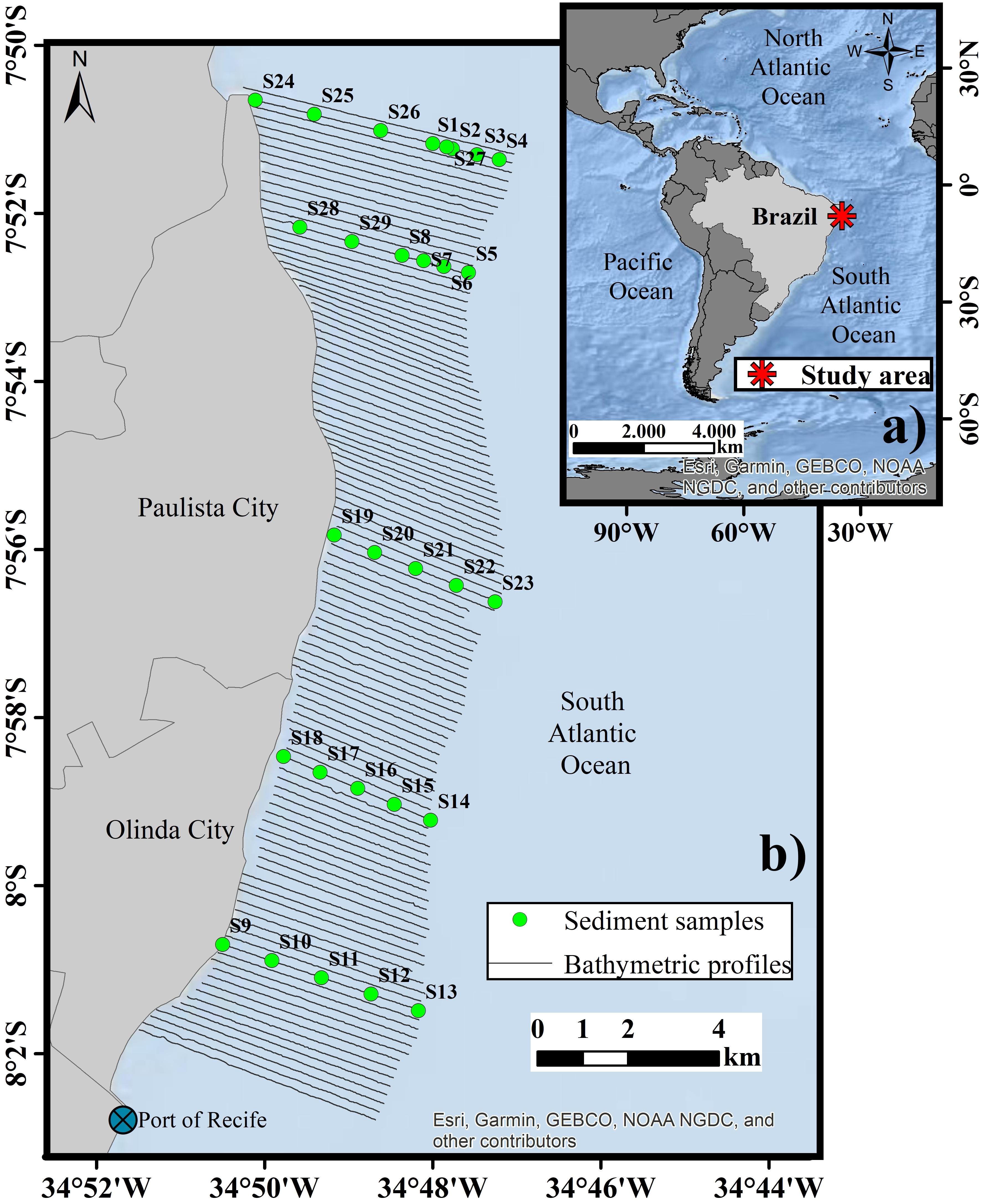
Figure 1. (a) Location map of the study area; (b) Bathymetric profiles surveyed and sediment samples at the study area.
One of the main features of the northeastern Brazilian coast and continental shelf is the peculiar characteristics of coral reef and beachrock features parallel to the main shoreline axis (Laborel, 1965; Dominguez et al., 1990; Maida and Ferreira, 1997; Costa et al., 2016; Leão et al., 2016). On the shallower portion of the Pernambuco continental shelf, the presence of beachrocks is a striking feature in the landscape. These sedimentary rocks are intertidal in the shallower parts running parallel to the shoreline, and are exposed during low tides, while remaining completely submerged at greater depths (Mabesoone, 1964; Laborel, 1970; Maida and Ferreira, 1997). The topography of the continental shelf includes both positive and negative features (reef banks of various origins, channels, among others), and the micro relief is a direct response of the seafloor to the prevailing hydrodynamic conditions (Araújo et al., 2004; Costa et al., 2016).
Materials and Methods
Bathymetric Data
The bathymetric database consists of single-beam echosoundings, collected in the scope of MAI Project (Financiadora de Estudos e Projetos [FINEP] and Universidade Federal de Pernambuco [UFPE], 2009). It was performed using a single-beam echosounder, operating at 200 kHz and integrating a Garmin 298 GPS with antenna for navigation and positioning, at a sampling rate of three soundings per seconds. For this study, 110 profiles were conducted between the coastline and the 20 m isobaths (Figure 1). These profiles were arranged perpendicular to the main axis of the coast and were spaced at approximate intervals of 200 m. All depth values were adjusted for tidal variation using tidal prediction form the Brazilian Hydrographic Service.
All bathymetric data (55,102 points) were pooled and submitted to a natural neighbor interpolation method to create a raster surface with 10 m cell size, to generate a digital bathymetric model (DBM) of the seafloor. This cell size was chosen because it best represented the existing conditions in the bathymetric profiles. Other tests were performed, with cells of 20, 40, and 100 m, in which loss of resolution was observed when comparing the interpolated surface to the bathymetric profiles of the area.
Increased survey density and use of multibeam echosounders provide the opportunity for higher reliability hydrographic survey, which would improve identification of seafloor morphology. The existing data set, with widely spaced survey lines, generates anisotropic effects in the spatial interpolation, creating artifacts, which are present in the final digital elevation model of the seafloor. This is an inherent issue related to the available survey data set. It should be noted that in a study comparing the accuracy of single-beam echo-sounder (SBE) against multibeam echo-sounder (MBE), it was found that maps produced with data acquired with the first have an average of 84% accuracy, while the second 91% (Parnum et al., 2009). We therefore consider the accuracy of the data for this study fit for purpose, allowing the first broad-scale.
Terrain Attributes Derived From Bathymetric Data
Terrain attributes can be quantitatively measured in a three-dimensional space and related to wildlife dynamics, making for the well-established field of geomorphometry (Bouchet et al., 2015). Then, these attributes derived from bathymetric data can be used as proxies for habitat studies (Bargain et al., 2018). As shown in the Digital Bathymetric Model (DBM) (Figure 2), terrain attributes such as seafloor slope and Bathymetric Position Index (BPI - at fine and broad-scales) were derived using the Benthic Terrain Modeler (BTM), an extension to ArcGIS (versions 10.x).
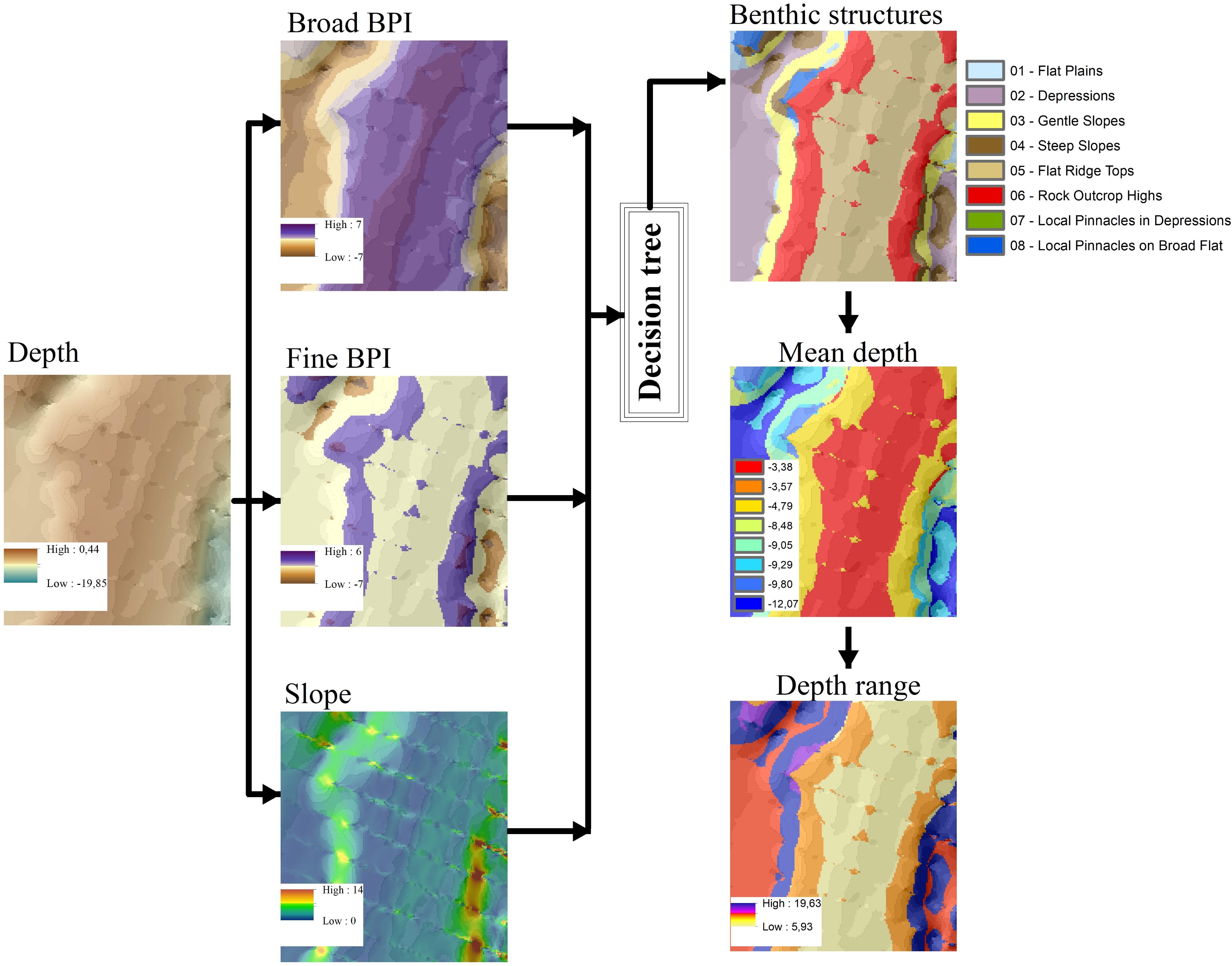
Figure 2. Flow chart of morphology classification scheme using terrain attributes for the study area. The final products (last image column) represent the topographical characteristics based on bathymetry and derived products (BPIs and slope).
Benthic Terrain Modeler is a GIS classification approach, which uses a combination of derived terrain attributes to segment the seafloor into geomorphic classes. It was developed by the Department of Geosciences of Oregon State University in collaboration with the National Oceanic and Atmospheric Administration (NOAA) GIS Integration and Development Program (Wright et al., 2005; Lundblad et al., 2006). Slope is defined as a gradient toward the maximum slope of the ocean floor (Lundblad et al., 2006; Jerosch et al., 2015). Expressed in degrees, it is understood as a fundamental ground attribute to the analysis of the seafloor, whereas the slope of the terrain exerts influence on the currents, influencing the rate of erosion in a given area and allowing different adjustments to the distribution of organisms (Kostylev et al., 2003). BPI is a measure of relative elevation of the general marine landscape. It calculates, on user-defined scales, the difference between the elevation of a DBM focal cell relative to the average elevation of surrounding cells (Erdey-Heydorn, 2008; Jerosch et al., 2015). Negative BPI values mean that focal cells have lower values than the surrounding cells, configuring structures such as valleys. Positive BPI values mean that focal cells have higher values than their surrounding ones, forming structures such as ridges. BPI values close to zero are related to flat or constant slope areas (Lundblad et al., 2006).
Once BPI data sets were created at both fine and broad-scales, the next step in the classification process was to standardize the values of these raster data sets, because the elevation tends to be spatially auto-correlated (Weiss, 2001; Erdey-Heydorn, 2008). These BPI data were standardized by subtracting the mean value of the BPI data from each BPI data point and dividing by the standard deviation; in this way the BPI data point had a value of 0 and the standard deviation had a value of -1/1. The standardized value of each data point was then multiplied by 100 (Wienberg et al., 2013). This allows for the same basic equations to be used to classify any scale combinations of BPI grids. The exact breakpoints among classes can be manually chosen to optimize the classification for a particular landscape and problem (Weiss, 2001). Therefore, conclusions about the structure of the overall seascape were produced with spatial analysis by applying an algorithm that combines standardized BPI grids of different scales with slope and bathymetry (Lundblad et al., 2006).
Geomorphological Classification
The geomorphological classification is based on the ensemble analysis between DBM, broad-scale and fine-scale of the Bathymetric Position Index (BPI), and slope (Figure 2). A decision table containing definitions and thresholds is applied to the data to classify the existing benthic structures in the study area (Table 1). The decision table used in this work is based on and adapted from previous works (Lundblad et al., 2006; Erdey-Heydorn, 2008; Wienberg et al., 2013), and defines eight benthic structure/potential habitats. These are Flat Plains (ID 01), Depressions (ID 02), Gentle Slopes (ID 03), Steep Slopes (ID 04), Flat Ridge Tops (ID 05), Rock Outcrop Highs (ID 06), Local Pinnacles in Depressions (ID 07), and Local Pinnacles on Broad Flats (ID 08).

Table 1. Decision table summarizing the factors used for the definition of benthic structures in the study area.
In order to obtain BPI in broad and fine-scales, inputs such as those from the literature (Lundblad et al., 2006; Erdey-Heydorn, 2008; Wienberg et al., 2013), were adapted to meet the requirements of the morphology of this tropical continental shelf. For fine-scale BPI, an internal radius of 10m and an external radius of 25 m were used. For the broad-scale, an internal radius of 10 m and an external radius of 100 m were chosen.
In the BTM, slope and the BPI grids were computed from the bathymetry raster. To avoid the influence of spatial autocorrelation in the broad-scale and fine-scale BPIs, the BPIs were standardized to 1 standard deviation, as proposed by Weiss (2001). For the geomorphological classification of the seafloor, the slope was used in the decision table (Table 1) to distinguish the thresholds between Flat Plains (ID 01) (up to 1 degree inclination), Gentle Slopes (ID 03) (1 to 5 degrees inclination), Steep slopes (greater than 5 degrees inclination) and Local Pinnacles on Broad Flats (ID 08) (up to 1 degree inclination). Previous studies conducted in areas with a large variation in depth have also used bathymetry (depth values) in the decision table to define benthic structures (Erdey-Heydorn, 2008). As the seafloor in our study site is delimited to 20 m isobath, the seafloor classes were not differentiated based on depth.
Sedimentological Characterization of Seafloor Classes
The relationships between morphology and the deposition of surface sediments were also investigated. The benthic structures, derived from the BTM analysis, were also analyzed in conjunction with the spatial variability of (gravel, sand and mud) fractions of the surface sediment samples.
Sedimentological characteristics were derived from 29 surficial grab samples (locations on Figure 1). The sedimentological analysis followed the methodology proposed by Suguio (1973) with wet and dry sieving. The resulting, sediment grain size (McLane, 1995) were analyzed using SysGran software and classified according to Folk (1954) into three classes: Gravel (>2 mm); Sand (2–0.062 mm); and Mud (<0.062 mm). In order to correlate the seafloor classes/benthic structures with the sedimentary surface composition, the percentages of mud (silt + clay), sand and gravel content of all the samples were also calculated.
Results
Benthic Structures
Based on the grids of bathymetry, slope, BPIs broad-scale and fine-scale, and the decision table (Table 1), eight classes of benthic structures were differentiated by the BTM (Figure 3). In relation to bathymetry, the DBM (Figure 3) revealed the identification of the heterogeneity of the geomorphological features, both in size and location, mainly due to the occurrence of bank reefs and channels. In the northern part of the study area, the bank reef is closed (i.e., attached) to the coast. However, in the central part it is possible to identify the presence of two elongated bank reefs, not attached to the coast, with channels between them.
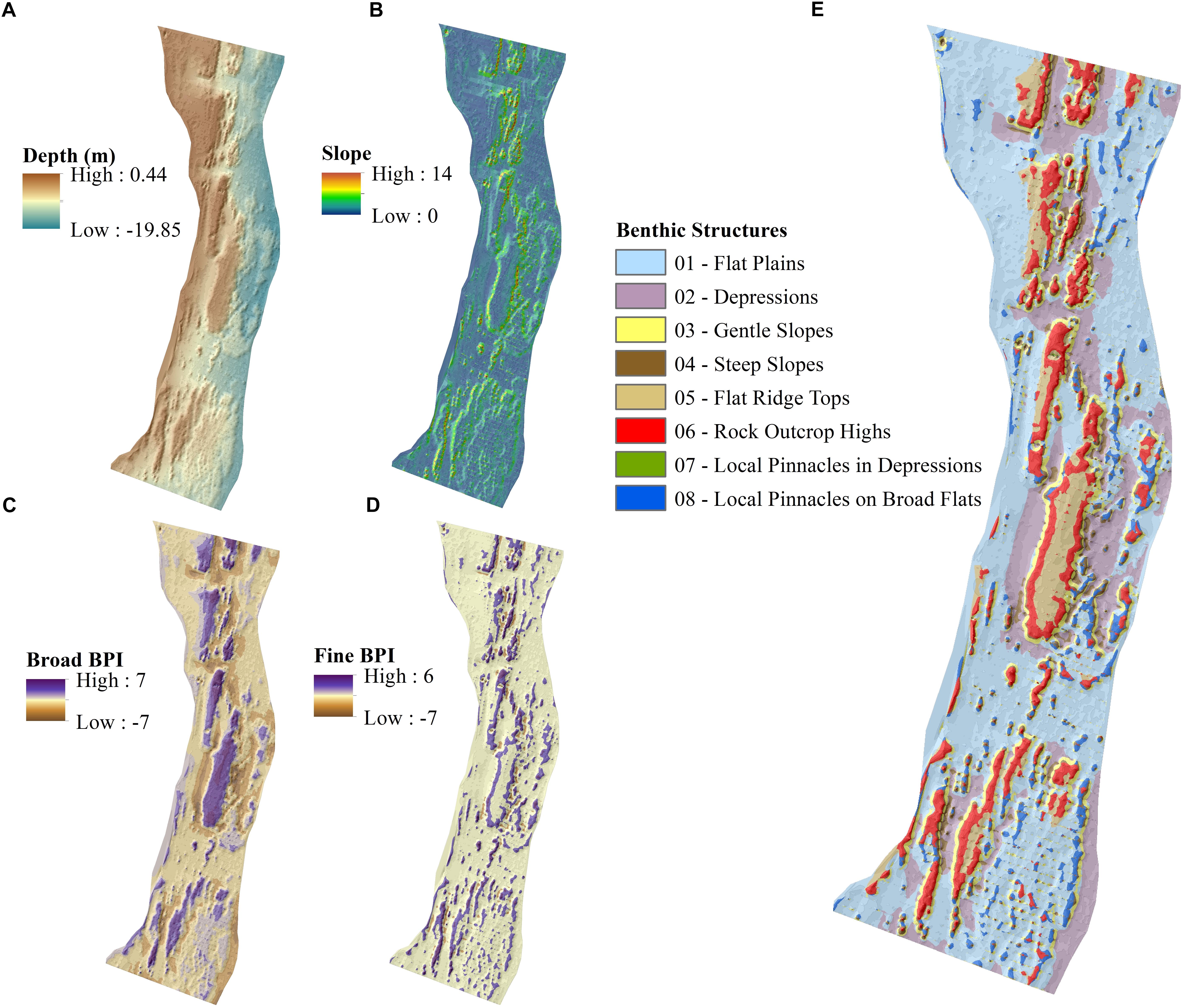
Figure 3. Bathymetry database and its derivatives: (A) Digital Bathymetric Model (DBM); (B) Slope; (C) Broad-scale Bathymetric Position Index (Broad-BPI); (C) Fine-scale Bathymetric Position Index (Fine–BPI); (E) Geomorphological classification of the study area.
In the transition to the southern part of the area, the presence of the reef banks is not as distinctive, occurring only as discontinuous features (small patches). The bank reefs are once again present in the southern region of the study site, but not as distinguished as in the central part of the area. The most pronounced changes in the slope are related to the heterogeneity of the depth gradient, delineating the occurrence of the positive and negative reliefs.
Broad-scale BPI demonstrates the major features of the marine landscape (e.g., reefs and channels), while the fine-scale BPI captures the subtler differences in the study area (e.g., outer edges of reefs). According to the broad-scale BPI, the reef and channel demarcation is observed where the mathematically higher differences (7) coincide with the reefs, while the lower (-7) coincide with the channels. The Fine-scale BPI highlight the subtle differences in the study area. This BPI grid shows the surrounding sectors of the large features (e.g. reefs and channels), marking the boundaries between these features and the flat regions of the seafloor.
Finally, eight classes of benthic structures (Figure 3 and Table 2) were recognized, occupying different percentages of surface on the explored area: Flat Plains (49.22%), Depressions (16.10%), Gentle Slopes (8.56%), Steep Slopes (5.03%), Flat Ridge Tops (5.80%), Rock Outcrop Highs (9.98%), Local Pinnacles in Depressions (>1%), and Local Pinnacles on Broad Flats (5.28%).
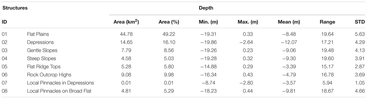
Table 2. Depth-related description of the geomorphological classification and the percentage of occurrence.
The Flat Plain (ID 01), was the most predominant class in the study area (49.22%), and was defined as the flat regions of the seafloor with BPI values close to zero. They are within the standard deviation of the mean (0) and have a soft slope (up to 1 degree inclination). Moreover, these areas have few changes in fine-scale BPI. Depressions (ID 02) were defined as low points on the ground, with BPIs values greater than one standard deviation from the mean in the negative direction (-1), occurring in 16.10% of the area.
Gentle Slopes (ID 03) were simpler relief zones, with no alternating of concave and convex areas. They have BPI close to zero, within the standard deviation of the mean (0), with slope varying between 1 and 5 degrees. In contrast, Steep Slopes (ID 04) were extensive regions of sloping seafloor, of BPI close to zero, within the standard deviation of the mean (0), with slope values greater than 5 degrees.
Flat Ridge Tops (ID 05) were areas where flat, broad-scale seafloor features are higher than the surrounding seafloor, and primarily comprising the top of narrow, linear structures running parallel to the coastline and without any slope. Rock Outcrop Highs (ID 06) were bathymetric high points in the field, with positive BPI values greater than one standard deviation of the mean in the positive direction (1). In these zones, the fine-scale and broad-scale features were less deep than the surroundings.
The Local Pinnacles in Depressions (ID 07) were narrow ridges within a sunken terrain, represented by the fine-scale BPI. They can be considered as high points in the field with positive BPI values greater than one standard deviation of the mean in the positive direction (1). Similarly, Local Pinnacles on Broad Flats (ID 08), correspond to narrow crests within a broader flat region of the seafloor highlighted by the fine-scale BPI. Like Local Pinnacles in Depressions (ID 07), they are considered as high points on the ground with positive BPI values greater than one standard deviation of the mean in the positive direction (1).
Association of Benthic Structures and Grain Size of the Surface Sediment
The analysis of the samples collected along the area also revealed the variety of sediment composition (Figure 4 and Table 3), according to the final classification shown in Figure 3E. In relation to the sedimentological composition (gravel, sand, and mud), it is observed that in the Depressions (ID 02) there is a predominance of sand, while in the Gentle Slopes (ID 03) there is an alternation between the dominance of the percentages of gravel and sand.
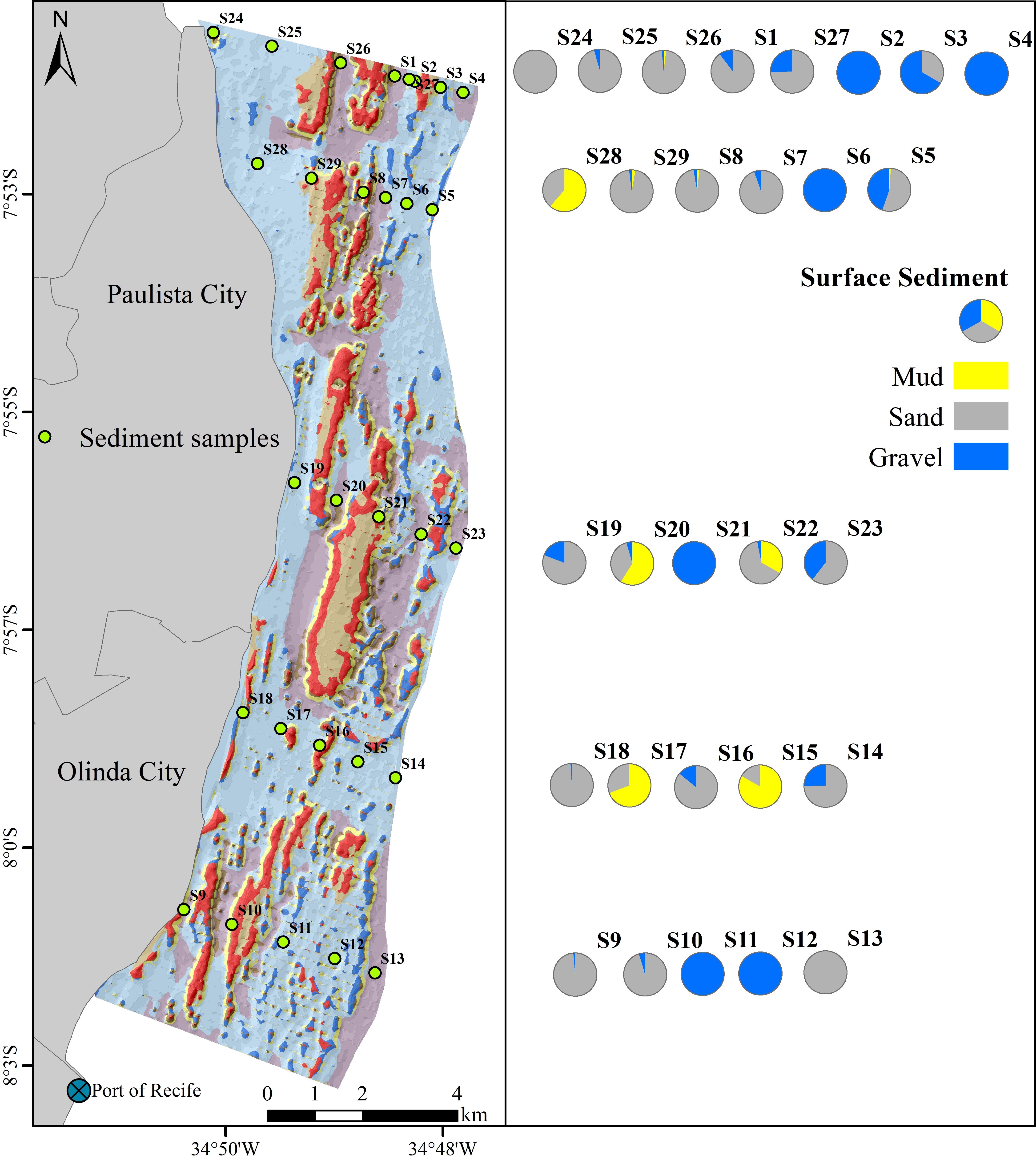
Figure 4. Spatial variability in the percentages of mud, sand and gravel contents in surface sediment.
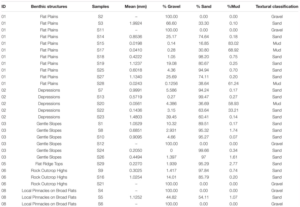
Table 3. Mean grain size, percentages of gravel, sand, and mud of surface sediment.
In Local Pinnacles on Broad Flats, there is a predominance of gravel, and in the Flat Plains (ID 01), there is a substantial variation among the percentages of the sediment components; however, it is in this structure that the highest percentages of mud are found. Flat Ridge Tops (ID 05) are represented by a higher percentage of sand while in Rock Outcrop Highs (ID 06) an alternation of larger values between gravel and sand was observed.
Discussion
In the study area, eight geomorphological classes are defined by the BTM, recognized as benthic structures (Figure 5). The benthic structures that occur in this tropical area highlight the heterogeneity and diversity of the seafloor of the study area. The results of the methodological process used in this study provide an unprecedented recognition of the relief patterns for the study area, not described in any previous study. The final classification can be considered a “potential habitat map” (Greene et al., 2007) and adds to the knowledge and understanding of the environmental characteristics of this area, but does not provide a complete description of benthic habitats for the study area due to the limited amount of ground validation data. However, particularly for ecosystem studies, can be considered that the morphology affects the distribution of benthic communities, influencing environmental factors (e.g. substrate, erosion or sediment deposition, currents and available nutrients) (Lundblad et al., 2006; Jerosch et al., 2015). On the other hand, according to Dartnell and Gardner (2004), a basic data set that describes the surficial characteristics of the seafloor is the baseline used for a habitat study, therefore important for ecological studies.
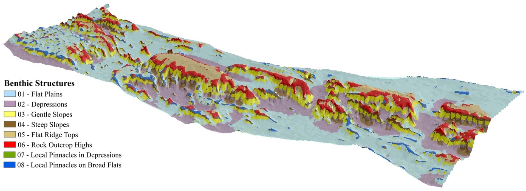
Figure 5. Geomorphological classification/benthic structures of the study area.
Although multibeam echosounder have emerged as the tool of choice for seafloor habitat modeling, because of their ability to collect both bathymetry and backscatter information simultaneously (Mumm, 2015), the use of single beam echosounder also demonstrates reasonable accuracy in seafloor habitat mapping (Parnum et al., 2009). In this sense, the proposed methodology, through the use of the BTM extension, functions as a first step for mapping the ocean floor, especially considering the widely spaced nature of available single beam surveys and the scarcity of multibeam survey data for this area. Wide spacing of survey lines creates anisotropic features in the spatial interpolation and may therefore influence the benthic habitat classification. However, in this location, the anisotropy is considered to be strongly offset by the geological structure, with long rocky ridges running almost parallel to shore. Residual effects of the interpolation include limited ability to identify slopes except along the survey lines, and large horizontal uncertainty in the alongshore scale and position of discontinuities, such as gaps between rock ridges. The constraints of survey coverage should be considered in conjunction with known characteristics of the local morphology when applying BTM to develop a potential benthic habitat model.
Pereira and Bonetti Filho (2018) presented an analysis of the background relief of three Brazilian conservation units, also from the BTM extension. National Marine Park of Fernando de Noronha (PARNAMAR Noronha), National Marine Park of Abrolhos (PARNAMAR Abrolhos), and the Biological Marine Reserve of Arvoredo (REBIOMAR Arvoredo). The analysis concluded that these areas have great morphological complexity of the seafloor. They suggested that the high biodiversity indexes, to a certain degree, may be associated with the high seafloor morphological complexity of the respective benthic structures (Pereira and Bonetti Filho, 2018).
Analysis of the sediment grain size samples in our study indicated that the highest percentage of mud was found in the Flat Plains (ID 01), while the Rock Outcrop Highs (ID 06) are marked by high levels of gravel. Likewise, in the northern region of the area, samples collected on structures classified as Local Pinnacles on Broad Flats (ID 08) were characterized by high gravel content. This configuration is observed in analyses conducted in the Weddell Sea, where coarser grain sizes appear in more exposed geomorphic features, such as crests and outcrops (Jerosch et al., 2015).
Such variation of the surficial sediment characteristics may indicate that this area has a greater variation in the communities that are associated to the sector, whereas different organisms suit the area depending on their particularities (Post, 2008; Verfaillie et al., 2009; McArthur et al., 2010). These patterns indicate possible heterogeneity in the potential distribution of benthic habitats, since changes in depth and mud contents are strongly correlated, and reflect distinct processes of association of benthic communities (Post et al., 2011).
Prominent structures on the seafloor in the study area may serve as useful proxies for estimating areas of higher biodiversity (Bouchet et al., 2015). Furthermore, the complexity of the rock forms itself presents both a greater surficial area for colonization and a greater variety of niche habitats than would a flat rock surface (Diesing et al., 2009).
The peculiar characteristics of coral reef and beachrocks feature parallel to the main shoreline axis (Laborel, 1965; Dominguez et al., 1990; Maida and Ferreira, 1997; Costa et al., 2016; Leão et al., 2016) is remarkable in this study area. These features are represented by the alternation of positive and negative BPIs, in addition to a relatively large slope.
It is concluded that approximately 40% of the area is formed by Gentle Slopes (ID 03), Steep Slopes (ID 04), Rock Outcrop Highs (ID 06), and Depressions (ID 02). These areas, which present greater morphological complexity, probably indicate regions supporting high biodiversity, given that geometrically complex surfaces are known to provide an abundance of stable, niche habitats exploited by a wide diversity of species (Kostylev et al., 2003; McArthur et al., 2010; Zawada et al., 2010; Darling et al., 2017). For this reason, they constitute a key ecological factor often positively linked to biodiversity and carry capacity of habitats (Yanovski et al., 2017; Rees et al., 2018). In contrast, 49.22% of the area is formed by Flat Plains (ID 01). These areas with low morphological complexity can be considered areas of lower biodiversity, as already observed in other studies (e.g., Kostylev et al., 2003; McArthur et al., 2010; Zawada et al., 2010; Darling et al., 2017).
The habitat heterogeneity, offered by this seafloor complexity, such as beachrocks features, is often associated with high biodiversity (Gladstone, 2007; Guevara-Fletcher et al., 2011). Studies have shown that features on the Australian shelf provide three-dimensional structures supporting benthic communities that contrast with the adjacent seabed, which is often flat (Brooke et al., 2017). Therefore, the importance of the recognition of the structural patterns present in the study area for marine environmental conservation and management plans is emphasized (Riegl and Piller, 2003).
Recently, Rinne et al. (2014) used large-scale bathymetric data to designate geographically complex areas of reef occurrences through the geomorphological analysis of the benthoscape on the northern Baltic Sea, with subsequent validation of the prediction ground-truthing. The results from our study may therefore assist in selecting priority areas to investigate, supporting improved marine spatial planning in the region, and, in the future, collaborate to determine biodiversity patterns. Furthermore, the results obtained in this work contribute to the achievement of the Aich Targets 2011–2020, regarding the improvement of the knowledge, scientific base and technologies related to the biodiversity in the Brazilian continental waters, besides the diffusion of generated knowledge (Ministério do Meio Ambiente [MMA], 2017).
Finally, this study has generated the first model of potential benthic habitats for this tropical area, which is particularly important for ecosystem studies. Over wider spatial scales or with coarser data resolutions (such as GEBCO data for example), the geomorphic classification algorithm needs to be adjusted for the scale and resolution of the underlying data.
Author Contributions
EG analyzed the data and prepared the manuscript. CB assisted in the preparation of the manuscript. TA secured funds, participated in field work, and assisted in the preparation of the manuscript. All authors have read and contributed to the final version of the text.
Funding
The bathymetric dataset used in this work was funded by the Brazilian Ministry of Science, Technology (MCT) and FINEP Innovation and Research through the following research projects: MAI – Monitoramento Ambiental Integrado da Erosão Costeira nos Municípios do Recife, Olinda, Paulista e Jaboatão dos Guararapes (01.05.0935.00 FINEP/UFPE/FADE).
Conflict of Interest Statement
The authors declare that the research was conducted in the absence of any commercial or financial relationships that could be construed as a potential conflict of interest.
Acknowledgments
EG acknowledges the M.Sc. Scholarship support of the Higher Education Personnel Training Coordination [Coordination for the Improvement of Higher Education Personnel (CAPES)–Brazil]. TA developed part of this manuscript during a sabbatical at Nova Scotia Community College, Canada. This manuscript is a contribution to the Brazilian National Institute of Science and Technology for Tropical Marine Environments–INCT AmbTropic (CNPq/FABESB Grants 565054/2010-4 and 8936/2011).
References
Araújo, T., de Seoane, J. C. S., and da Coutinho, P. N. (2004). “Geomorfologia da plataforma continental de Pernambuco,” in Ça EE Neumann-Leitão Costa MF Oceanogr. Um Cenário Trop, eds E. E. Leça, S. Neumann-Leitão, and M. F. e Costa (Recife: Recife Bagaço), 39–57.
Bargain, A., Foglini, F., Pairaud, I., Bonaldo, D., Carniel, S., Angeletti, L., et al. (2018). Predictive habitat modeling in two mediterranean canyons including hydrodynamic variables. Prog. Oceanogr. 169, 151–168. doi: 10.1016/j.pocean.2018.02.015
Bouchet, P. J., Meeuwig, J. J., Salgado Kent, C. P., Letessier, T. B., and Jenner, C. K. (2015). Topographic determinants of mobile vertebrate predator hotspots: current knowledge and future directions: landscape models of mobile predator hotspots. Biol. Rev. 90, 699–728. doi: 10.1111/brv.12130
Brooke, B. P., Nichol, S. L., Huang, Z., and Beaman, R. J. (2017). Palaeoshorelines on the Australian continental shelf: morphology, sea-level relationship and applications to environmental management and archaeology. Cont. Shelf Res. 134, 26–38. doi: 10.1016/j.csr.2016.12.012
Brown, C. J., Sameoto, J. A., and Smith, S. J. (2012). Multiple methods, maps, and management applications: purpose made seafloor maps in support of ocean management. J. Sea Res. 72, 1–13. doi: 10.1016/j.seares.2012.04.009
Brown, C. J., Smith, S. J., Lawton, P., and Anderson, J. T. (2011). Benthic habitat mapping: a review of progress towards improved understanding of the spatial ecology of the seafloor using acoustic techniques. Estuar. Coast. Shelf Sci. 92, 502–520. doi: 10.1016/j.ecss.2011.02.007
Camargo, J. M. R., Araújo, T. C. M., Ferreira, B. P., and Maida, M. (2015). Topographic features related to recent sea level history in a sediment-starved tropical shelf: linking the past, present and future. Reg. Stud. Mar. Sci. 2, 203–211. doi: 10.1016/j.rsma.2015.10.009
Costa, M. B. S. F., Araújo, M., Araújo, T. C. M., and Siegle, E. (2016). Influence of reef geometry on wave attenuation on a Brazilian coral reef. Geomorphology 253, 318–327. doi: 10.1016/j.geomorph.2015.11.001
Darling, E. S., Graham, N. A. J., Januchowski-Hartley, F. A., Nash, K. L., Pratchett, M. S., and Wilson, S. K. (2017). Relationships between structural complexity, coral traits, and reef fish assemblages. Coral Reefs 36, 561–575. doi: 10.1007/s00338-017-1539-z
Dartnell, P., and Gardner, J. V. (2004). Predicted Seafloor Facies of Central Santa Monica Bay, California. USGS Open-file Report 2004-1081, Reston, VA: U.S. Geological Survey.
Diesing, M., Coggan, R., and Vanstaen, K. (2009). Widespread rocky reef occurrence in the central english channel and the implications for predictive habitat mapping. Estuar. Coast. Shelf Sci. 83, 647–658. doi: 10.1016/j.ecss.2009.05.018
Dominguez, J. M. L., Bittencourt, A., Leão, Z., and Azevedo, A. E. G. (1990). Geologia do quaternário costeiro do estado de pernambuco. Rev. Bras. Geociências 20, 208–215. doi: 10.25249/0375-7536.1990208215
Erdey-Heydorn, M. D. (2008). An ArcGIS seabed characterization toolbox developed for investigating benthic habitats. Mar. Geod. 31, 318–358. doi: 10.1080/01490410802466819
Financiadora de Estudos e Projetos [FINEP], and Universidade Federal de Pernambuco [UFPE] (2009). Monitoramento Ambiental Integrado – MAI-PE. Recife: FINEP.
Folk, R. L. (1954). The distinction between grain size and mineral composition in sedimentary-rock nomenclature. J. Geol. 62, 344–359. doi: 10.1086/626171
Gladstone, W. (2007). Requirements for marine protected areas to conserve the biodiversity of rocky reef fishes. Aquat. Conserv. Mar. Freshw. Ecosyst. 17, 71–87. doi: 10.1002/aqc.759
Goes, E. R., and Ferreira, A. V. Jr. (2017). Caracterização morfossedimentar da plataforma continental Brasileira. Rev. Bras. Geogr. Física 10, 1595–1613. doi: 10.26848/rbgf.v.10.5.p1595-1613
Greene, H. G., Bizzarro, J. J., O’Connell, V. M., and Brylinsky, C. K. (2007). “Construction of digital potential marine benthic habitat maps using a coded classification scheme and its application,” in Mapping the Seafloor for Habitat Characterization, Vol. 47, eds B. J. Todd and H. G. Greene (St. John’s: Geological Association of Canada), 141–155.
Greene, H. G., Bizzarro, J. J., Tilden, J. E., Lopez, H. L., and Erdey, M. D. (2005). “The benefits and pitfalls of geographic information systems in marine benthic habitat mapping,” in Place Matters, eds D. J. Wright and A. J. Scholz (Portland, OR: State University Press), 34–46.
Guevara-Fletcher, C. E., Cantera Kintz, J. R., Mejía-Ladino, L. M., and Cortés, F. A. (2011). Benthic macrofauna associated with submerged bottoms of a tectonic estuary in Tropical Eastern Pacific. J. Mar. Biol. 2011:193759. doi: 10.1155/2011/193759
Harris, P. T. (2012). “Biogeography, benthic ecology, and habitat classification schemes,” in Seafloor Geomorphol. Benthic Habitat GeoHAB Atlas Seafloor Geomorphic Featur. Benthic Habitats, eds P. T. Harris and E. K. Baker (Amsterdam: Elsevier Incorporated), 61–92.
Harris, P. T., and Baker, E. K. (eds) (2012). Seafloor Geomorphology as Benthic Habitat: GeoHAB Atlas of Seafloor Geomorphic Features and Benthic Habitats, 1st Edn. Boston: Elsevier.
Jerosch, K., Kuhn, G., Krajnik, I., Scharf, F. K., and Dorschel, B. (2015). A geomorphological seabed classification for the Weddell Sea, Antarctica. Mar. Geophys. Res. 37, 127–141. doi: 10.1007/s11001-015-9256-x
Kostylev, V. E., Courtney, R. C., Robert, G., and Todd, B. J. (2003). Stock evaluation of giant scallop (Placopecten magellanicus) using high-resolution acoustics for seabed mapping. Fish. Res. 60, 479–492. doi: 10.1016/S0165-7836(02)00100-5
Laborel, J. (1970). Madréporaires et Hydrocoralliaires Récifaux des Cotes Brésiliennes: Systématique, Écologie, Répartition Verticale et Géographique. Fairfax, VA: Masson.
Leão, Z. M. A. N., Kikuchi, R. K. P., Ferreira, B. P., Neves, E. G., Sovierzoski, H. H., Oliveira, M. D. M., et al. (2016). Brazilian coral reefs in a period of global change: a synthesis. Braz. J. Oceanogr. 64, 97–116. doi: 10.1590/S1679-875920160916064sp2
Lecours, V., Brown, C. J., Devillers, R., Lucieer, V. L., and Edinger, E. N. (2016). Comparing selections of environmental variables for ecological studies: a focus on terrain attributes. PLoS One 11:e0167128. doi: 10.1371/journal.pone.0167128
Lecours, V., Devillers, R., Schneider, D. C., Lucieer, V. L., Brown, C. J., and Edinger, E. N. (2015). Spatial scale and geographic context in benthic habitat mapping: review and future directions. Mar. Ecol. Prog. Ser. 535, 259–284. doi: 10.3354/meps11378
Lundblad, E. R., Wright, D. J., Miller, J., Larkin, E. M., Rinehart, R., Naar, D. F., et al. (2006). A benthic terrain classification scheme for American Samoa. Mar. Geod. 29, 89–111. doi: 10.1080/01490410600738021
Mabesoone, J. M. (1964). Origin and age of the sandstone reefs of Pernambuco (Northeastern Brazil). J. Sediment. Res. 34, 715–726. doi: 10.1306/74D71177-2B21-11D7-8648000102C1865D
Maida, M., and Ferreira, B. P. (1997). “Coral reefs of Brazil: an overview,” in Proceedings of the 8th International Coral Reef Symposium, Panama.
Manso, V. A. V., Valença, L. M. M., Coutinho, P. N., and Guerra, N. C. (2004). “Sedimentologia da plataforma continental,” in Oceanografia: um Cenário Tropical, (Recife: Bagaço).
McArthur, M. A., Brooke, B. P., Przeslawski, R., Ryan, D. A., Lucieer, V. L., Nichol, S., et al. (2010). On the use of abiotic surrogates to describe marine benthic biodiversity. Estuar. Coast. Shelf Sci. 88, 21–32. doi: 10.1016/j.ecss.2010.03.003
Ministério do Meio Ambiente [MMA]. (2017). Estratégia e Plano de Ação Nacionais Para a Biodiversidade. Brasília: MMA.
Mumm, J. D. (2015). Bathymetric-Based Habitat Model for Yelloweye Rockfish (Sebastes ruberrimus) on Alaska’s Outer Kenai Peninsula. Anchorage, AK: Aquatic Science & Technology Laboratory at Alaska Pacific University.
Parnum, I., Siwabessy, J., Gavrilov, A., and Parsons, M. (2009). “A comparison of single beam and multibeam sonar systems in seafloor habitat mapping,” in Proceedings. 3rd International Conference and Exhibition of Underwater Acoustic Measurements: Technologies & Results, Nafplion, 155–162.
Pereira, M. L. M., and Bonetti Filho, J. (2018). Caracterização geomorfológica do relevo submarino de áreas marinhas protegidas brasileiras com base em técnicas de análise espacial. Rev. Bras. Geomorfol. 19, 127–147.
Pittman, S. J., Caldow, C., Hile, S. D., and Monaco, M. E. (2007). Using seascape types to explain the spatial patterns of fish in the mangroves of SW Puerto Rico. Mar. Ecol. Prog. Ser. 348, 273–284. doi: 10.3354/meps07052
Post, A. L. (2008). The application of physical surrogates to predict the distribution of marine benthic organisms. Ocean Coast. Manag. 51, 161–179. doi: 10.1016/j.ocecoaman.2007.04.008
Post, A. L., Beaman, R. J., O’Brien, P. E., Eléaume, M., and Riddle, M. J. (2011). Community structure and benthic habitats across the George V Shelf, East Antarctica: trends through space and time. Deep Sea Res. Part II Top. Stud. Oceanogr. 58, 105–118. doi: 10.1016/j.dsr2.2010.05.020
Rees, M. J., Knott, N. A., Neilson, J., Linklater, M., Osterloh, I., Jordan, A., et al. (2018). Accounting for habitat structural complexity improves the assessment of performance in no-take marine reserves. Biol. Conserv. 224, 100–110. doi: 10.1016/j.biocon.2018.04.040
Riegl, B., and Piller, W. E. (2003). Possible refugia for reefs in times of environmental stress. Int. J. Earth Sci. 92, 520–531. doi: 10.1371/journal.pone.0081172
Rinne, H., Kaskela, A., Downie, A.-L., Tolvanen, H., von Numers, M., and Mattila, J. (2014). Predicting the occurrence of rocky reefs in a heterogeneous archipelago area with limited data. Estuar. Coast. Shelf Sci. 138, 90–100. doi: 10.1016/j.ecss.2013.12.025
Verfaillie, E., Degraer, S., Schelfaut, K., Willems, W., and Van Lancker, V. (2009). A protocol for classifying ecologically relevant marine zones, a statistical approach. Estuar. Coast. Shelf Sci. 83, 175–185. doi: 10.1016/j.ecss.2009.03.003
Vital, H., Esteves, L. S., Araújo, T. C. M., and Patchineelam, S. M. (2005). “Oceanografia geológica e geofísica da plataforma continental brasileira,” in Quaternário Brasil, eds C. R. D. G. Souza and K. Suguio (Ribeirão Preto: Holos Editora), 153–175.
Weiss, A. (2001). “Topographic position and landforms analysis,” in Poster at the ESRI User Conference, San Diego, CA.
Wienberg, C., Wintersteller, P., Beuck, L., and Hebbeln, D. (2013). Coral Patch seamount (NE Atlantic)-a sedimentological and megafaunal reconnaissance based on video and hydroacoustic surveys. Biogeosciences 10:3421. doi: 10.5194/bg-10-3421-2013
Wright, D. J., Lundblad, E. R., Larkin, E. M., Rinehart, R. W., Murphy, J., Cary-Kothera, L., et al. (2005). ArcGIS Benthic Terrain Modeler [a Collection of Tools Used with Bathymetric Data Sets to Examine the Deepwater Benthic Environment]. Or. State Univ. Davey Jones’ Locker Seafloor MappingMarine GIS Lab. Charleston, SC: NOAA Coastal Services Centre.
Yanovski, R., Nelson, P. A., and Abelson, A. (2017). Structural complexity in coral reefs: examination of a novel evaluation tool on different spatial scales. Front. Ecol. Evol. 5:27. doi: 10.3389/fevo.2017.00027
Zajac, R. N. (2008). Challenges in marine, soft-sediment benthoscape ecology. Landsc. Ecol. 23, 7–18. doi: 10.1007/s10980-007-9140-4
Zajac, R. N., Lewis, R. S., Poppe, L. J., Twichell, D. C., Vozarik, J., and DiGiacomo-Cohen, M. L. (2003). Responses of infaunal populations to benthoscape structure and the potential importance of transition zones. Limnol. Oceanogr. 48, 829–842. doi: 10.4319/lo.2003.48.2.0829
Keywords: potential habitats, Benthic Terrain Modeler, terrain attributes, single-beam echosounder, tropical Atlantic Ocean
Citation: Goes ER, Brown CJ and Araújo TC (2019) Geomorphological Classification of the Benthic Structures on a Tropical Continental Shelf. Front. Mar. Sci. 6:47. doi: 10.3389/fmars.2019.00047
Received: 31 October 2018; Accepted: 28 January 2019;
Published: 19 February 2019.
Edited by:
Gabriel Machovsky-Capuska, The University of Sydney, AustraliaReviewed by:
Matthew John Eliot, Damara WA Pty Ltd, AustraliaJ. German Rodriguez, Centro Tecnológico Experto en Innovación Marina y Alimentaria (AZTI), Spain
Copyright © 2019 Goes, Brown and Araújo. This is an open-access article distributed under the terms of the Creative Commons Attribution License (CC BY). The use, distribution or reproduction in other forums is permitted, provided the original author(s) and the copyright owner(s) are credited and that the original publication in this journal is cited, in accordance with accepted academic practice. No use, distribution or reproduction is permitted which does not comply with these terms.
*Correspondence: Enatielly R. Goes, enatielly.goes@ufpe.br