ETOPO 2022 15 Arc-Second Global Relief Model
 Thumbnail of ETOPO
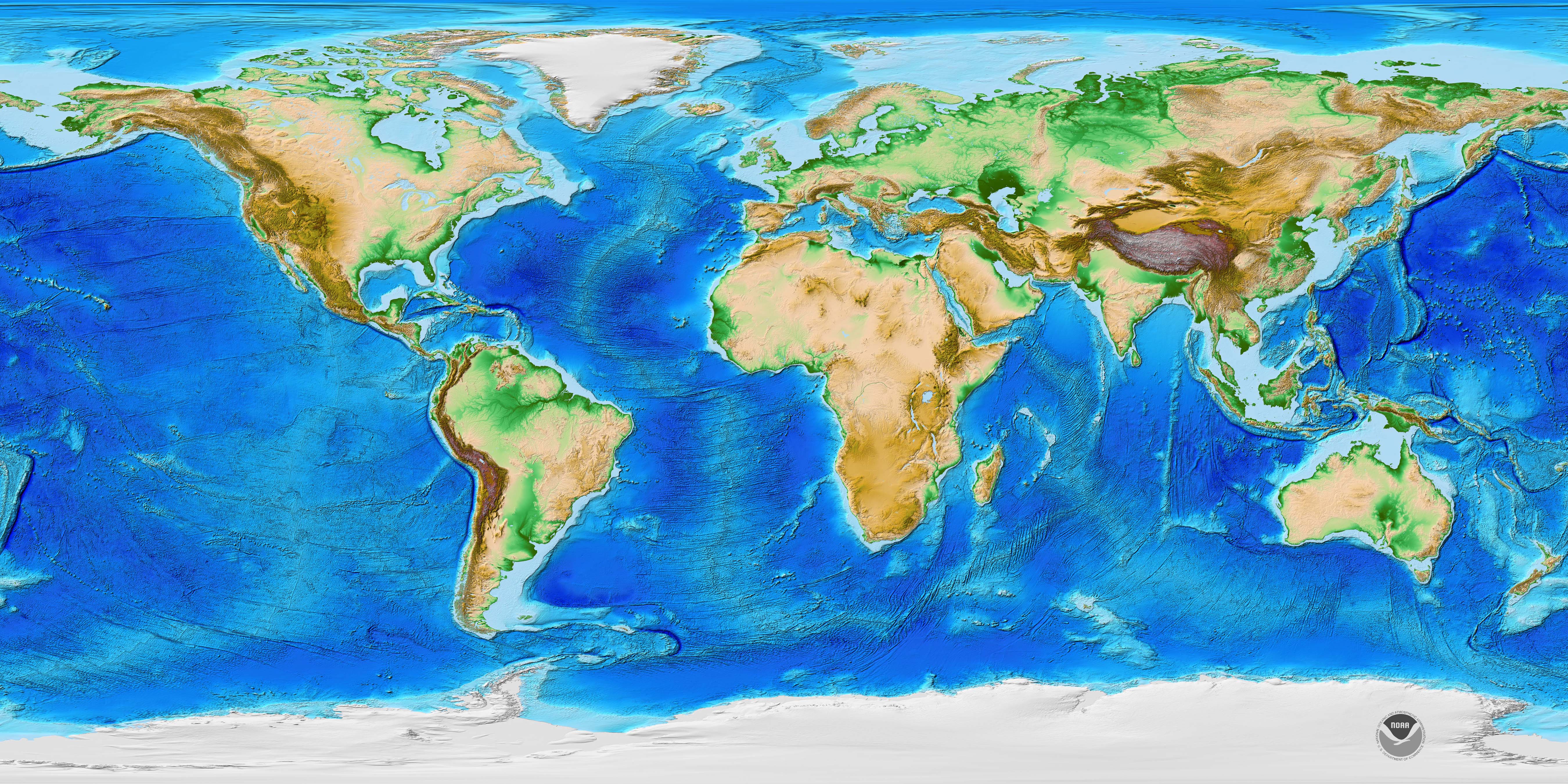
ETOPO 2022, a global relief model with 15 arc-second resolution seamlessly integrating
topographic and bathymetric data. The ETOPO 2022 model uses a combination of numerous
airborne lidar, satellite-derived topography, and shipborne bathymetry datasets from
U.S. national and global sources. ETOPO 2022 uses bare-earth topographic data from
NASAs ICESat-2 and other vetted data sources to independently validate both the input
datasets and the final ETOPO 2022 model. ETOPO 2022 is available in "Ice Surface"
(top of Antarctic and Greenland ice sheets) and "Bedrock" (base of the ice sheets)
versions.
- Cite as:NOAA National Centers for Environmental Information. 2022: ETOPO 2022 15 Arc-Second Global Relief Model. NOAA National Centers for Environmental Information. https://doi.org/10.25921/fd45-gt74 . Accessed [date].
- 10.25921/fd45-gt74
- NCEI Metadata ID: gov.noaa.ngdc.mgg.dem:etopo_2022
gov.noaa.ngdc.mgg.dem:etopo_2022
| Download Data |
|
| Distribution Formats |
|
| Ordering Instructions | Contact NCEI for other distribution options and instructions. |
| Distributor | NOAA National Centers for Environmental Information ncei.info@noaa.gov |
| Dataset Point of Contact | NOAA National Centers for Environmental Information ncei.info@noaa.gov |
| Dataset Point of Contact | DEM Information NOAA National Centers for Environmental Information dem.info@noaa.gov |
| Time Period | 1998-01-01 to 2022-09-01 |
| Spatial Reference System | urn:ogc:def:crs:EPSG::4326urn:ogc:def:datum:EPSG::3855 |
| Spatial Bounding Box Coordinates |
West:-180.00
East:180.00
South:-90.00
North:90.00
|
| Spatial Coverage Map | |
| General Documentation | |
| Associated Resources |
|
| Publication Dates |
|
| Dataset Progress Status | Complete - production of the data has been completed Historical archive - data has been stored in an offline storage facility |
| Data Update Frequency | As needed |
| Purpose | This data is available to the public for a wide variety of uses including scientific research and analysis. |
| Use Limitations |
|
| Dataset Citation |
|
| Originators |
|
| Publishers |
|
| Theme keywords | Global Change Master Directory (GCMD) Science Keywords
|
| Data Center keywords | Global Change Master Directory (GCMD) Data Center Keywords
|
| Platform keywords | Global Change Master Directory (GCMD) Platform Keywords
|
| Place keywords | Global Change Master Directory (GCMD) Location Keywords
|
| Data Resolution keywords | Global Change Master Directory (GCMD) Horizontal Data Resolution Keywords
|
| Use Constraints |
|
| Access Constraints |
|
| Other Constraints | Cite as:NOAA National Centers for Environmental Information. 2022: ETOPO 2022 15 Arc-Second Global Relief Model. NOAA National Centers for Environmental Information. https://doi.org/10.25921/fd45-gt74 . Accessed [date]. |
| Other Constraints | These data were produced by NOAA and are not subject to copyright protection in the United States. NOAA waives any potential copyright and related rights in these data worldwide through the Creative Commons Zero 1.0 Universal Public Domain Dedication (CC0-1.0). |
| Other Constraints | SPDX License: Creative Commons Zero v1.0 Universal (CC0-1.0) |
| Fees |
|
| Processor |
|
| Processing Steps |
|
| Processing Environment | Linux OS |
| Source Datasets |
|
| Processing Steps |
|
Last Modified: 2023-12-08-06:00
For questions about the information on this page, please email:ncei.info@noaa.gov