
Keywords
Classifiers
Machine learning
How to Cite
Abstract
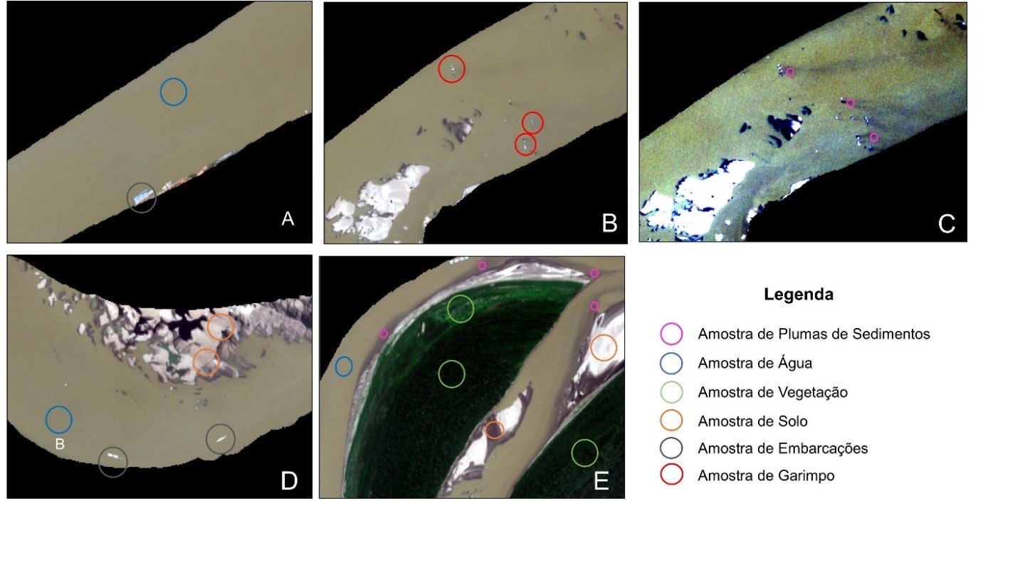
Artisanal and small-scale gold mining can occur on land or in riverbeds. However, the activity needs to be supported by a Mining Permit, issued by the Agência Nacional de Mineração, and the appropriate environmental license from the competent environmental agency. The use of images from Sentinel-2 satellites presents itself as a potential tool for identifying gold mining vessels due to the temporal resolution, free imagery, global coverage, and more refined spatial resolution. So, this study aimed to identify gold mining vessels on the Madeira River near Porto Velho city, Rondônia state, located at Brazilian Amazon, in 13 Sentinel-2 images from 2018 to 2021 using the classifiers: Support Vector Machine (SVM), K-Nearest Neighbors (KNN) Random Forest (RF) and Spectral Angle Mapper (SAM). The results showed that machine learning classifiers obtained the best performance, especially the object-oriented SVM classifier, which had the best average F1 score (0.91). In addition, the detection percentage of gold mining vessels originated by this classifier was satisfactory, with only 0 to 4 active gold mining vessels with sediment plumes being omitted per image. Therefore, based on the results obtained, it was concluded that the use of machine learning classifiers proved to be effective in identifying gold mining vessels.
References
ADAMY, A. Dinâmica fluvial do Rio Madeira. In: SILVA, R.G.C. (org.). Porto Velho: cultura, natureza e território. p. 120–147, 2016.
ASNER, G. P.; LLACTAYO, W.; TUPAYACHI, R.; LUNA, E.R. Elevated rates of gold mining in the Amazon revealed through high-resolution monitoring. Proceedings of the National Academy of Sciences, v. 110, n. 46, p. 18454–18459, 29 out. 2013. https://doi.org/10.1073/pnas.1318271110
ARCGIS PRO. Segmentation. Disponível em: https://pro.arcgis.com/en/pro-app/latest/help/analysis/image-analyst/segmentation.htm. Acesso em: 15 abr. 2023.
BALZINO, M.; SECCATORE, J.; MARIN, T.; DE TOMI, G. Gold losses and mercury recovery in artisanal gold mining on the Madeira River, Brazil. Journal of Cleaner Production, v. 102, p. 370–377, 2015. https://doi.org/10.1016/j.jclepro.2015.05.012
BARBOSA, C. C. F. Sensoriamento Remoto da Dinâmica da Circulação da Água do Sistema Planície de Curuai/Rio Amazonas. 2005. São José dos Campos (SP). 281 p. (Tese de Doutoramento, Instituto Nacional de Pesquisas Espaciais).
BARBOSA, C. C. F.; NOVO, E. M. L. M.; MARTINS, V. S. Introdução ao Sensoriamento Remoto de Sistemas Aquáticos: Princípios e Aplicações. São José dos Campos. Instituto Nacional de Pesquisas Espaciais. 2019.
BARBOSA, F. L. R.; GUIMARÃES, R.F.; CARVALO JÚNIOR, O.A.; GOMES, R.A.T. Classificação do uso e cobertura da terra utilizando imagens SAR/Sentinel 1 no Distrito Federal. Sociedade & Natureza, v. 32, p. e55954, 2 fev. 2021. https://doi.org/10.14393/SN-v33-2021-55954
BEZERRA, R. B.; DANTAS, T. R.; TRINDADE, A. G. Caracterização Temporal da Precipitação Pluvial no Município de Porto Velho/RO no Período de 1945 a 2003. Sociedade & Natureza, v. 22, n. 3, p. 609–623, 2010. https://doi.org/10.1590/S1982-45132010000300015
BRASIL. Lei No 7.805, de 18 de julho de 1989. Disponível em: https://presrepublica.jusbrasil.com.br/legislacao/103411/lei-7805-89/. Acesso em: 02 ago. 2022.
BRASIL. Catálogo de Metadados. 2022. Disponível em: https://metadados.snirh.gov.br/geonetwork/srv/por/catalog.search#/metadata/7d054e5a-8cc9-403c-9f1a-085fd933610c. Acesso em: 04 set. 2022.
BREIMAN, L. Random Forests. Machine Learning, v. 45, n. 1, p. 5–32, 2001. https://doi.org/10.1023/A:1010933404324
CAO, R.; TU, W.; YANG, C.; LI, Q.; LIU, J.; ZHU, J.; ZHANG, Q.; LI, Q.; QIU, G. Deep learning-based remote and social sensing data fusion for urban region function recognition. ISPRS Journal of Photogrammetry and Remote Sensing, v. 163, n. February, p. 82–97, 2020. https://doi.org/10.1016/j.isprsjprs.2020.02.014
CETEM. Inventário Nacional de Emissões e Liberações de Mercúrio pelos Garimpos de Ouro. 2018. Disponível em: https://diretoriopre.mma.gov.br. Acesso em: 29 jul. 2022.
CIOCARLAN, A.; STOIAN, A. Ship detection in sentinel 2 multi-spectral images with self-supervised learning. Remote Sensing, v. 13, n. 21, 1 nov. 2021. https://doi.org/10.3390/rs13214255
COMANICIU, D.; MEER, P. Mean shift: A robust approach toward feature space analysis. IEEE Transactions on Pattern Analysis and Machine Intelligence, v. 24, n. 5, p. 603–619, 2002. https://doi.org/10.1109/34.1000236
DECHESNE, C.; LEFÈVRE, S.; VADAIME, R.; HAJDUCH, G.; FABLET, R. Ship identification and characterization in Sentinel-1 SAR images with multi-task deep learning. Remote Sensing, v. 11, n. 24, p. 1–18, 2019. https://doi.org/10.3390/rs11242997
ESA. Sentinel-2 User Handbook. 2015. Disponível em: https://sentinels.copernicus.eu/documents/247904/685211/Sentinel-2_User_Handbook.pdf/8869acdf-fd84-43ec-ae8c-3e80a436a16c?t=1438278087000. Accessed on: 03 ago. 2022.
ESPINOZA VILLAR, R.; MARTINEZ, J.M.; TEXIER, M.; GUYOT, J.L.; FRAIZY, P.; MENESES, P.R.; OLIVEIRA, E. A study of sediment transport in the Madeira River, Brazil, using MODIS remote-sensing images. Journal of South American Earth Sciences, v. 44, p. 45–54, 2013. https://doi.org/10.1016/j.jsames.2012.11.006
FERNANDES, F. R. C.; ALAMINO, R. C. J.; ARAUJO. E. Recursos minerais e comunidade: impactos humanos, socioambientais e econômicos. Rio de Janeiro. CETEM. 2014.
FIX, E; HODGES; J. L. JR. Discriminatory analysis, nonparametric discrimination. USAF School of Aviation Medivine, Randolph Field, Tex., Project 21-49-004, Rept. 4, AF41(128)-31, February 1951.
GOODIN, D. G.; HAN, L.; FRASER, R.N.; RUNDQUIST, D.C.; STEBBINS, W.A.; SCHALLES, J.F. Analysis of suspended solids in water using remotely sensed high resolution derivative spectra. Photogrammetric Engineering & Remote Sensing, v. 54, n. 4, p. 505–510, 1993.
HARTONI, H.; SIREGAR, V.P.; WOUTHUYZEN, S.; AGUS, S.B. Object based classification of benthic habitat using Sentinel 2 imagery by applying with support vector machine and random forest algorithms in shallow waters of Kepulauan Seribu, Indonesia. Biodiversitas, v. 23, n. 1, p. 514–520, 1 jan. 2022. https://doi.org/10.13057/biodiv/d230155
HEISELBERG, H. A direct and fast methodology for ship recognition in sentinel-2 multispectral imagery. Remote Sensing, v. 8, n. 12, 1 dez. 2016. https://doi.org/10.3390/rs8121033
HEISELBERG, P.; HEISELBERG, H. Ship-iceberg discrimination in Sentinel-2 multispectral imagery by supervised classification. Remote Sensing, v. 9, n. 11, 1 nov. 2017. https://doi.org/10.3390/rs9111156
ISIDRO, C. M.; MCINTYRE, N.; LECHER, A.M.; CALLOW, I. Applicability of earth observation for identifying small-scale mining footprints in a wet tropical region. Remote Sensing. v.9, n.9, p. 945, 12 sep. 2017. https://doi.org/10.3390/rs9090945
KANJIR, U. Detecting migrant vessels in the Mediterranean Sea: Using Sentinel-2 images to aid humanitarian actions. Acta Astronautica. v. 155, p. 45–50, 1 fev. 2019. https://doi.org/10.1016/j.actaastro.2018.11.012
KESHTKAR, H.; VOIGT, W.; ALIZADEH, E. Land-cover classification and analysis of change using machine-learning classifiers and multi-temporal remote sensing imagery. Arabian Journal of Geosciences, v. 10, n. 6, 1 mar. 2017. https://doi.org/10.1007/s12517-017-2899-y
KIKAKI, K.; KAKOGEORGIOU, I.; MIKELI, P.; RAITSOS, D.; KARANTZALOS, K. MARIDA: A benchmark for Marine Debris detection from Sentinel-2 remote sensing data. PLoS ONE, v. 17, n. 1 January, 1 jan. 2022. https://doi.org/10.1371/journal.pone.0262247
KRUSE, F. A.; LEFKOFF, A.B.; BOARDMAN, J.B.; HEIDEBRECHT, K.B.; SHAPIRO, A.T.; BARLOON, P.J.; GOETZ, A.F.H. The Spectral Image Processing System (SIPS) - Interactive Visualization and Analysis of Imaging spectrometer Data. Remote Sensing of Environment, v. 44, p. 145–163, 1993. https://doi.org/10.1016/0034-4257(93)90013-N
LODI, L. A; FRANZINI, M; CASELLA, V. Mapping Land Cover Types using Sentinel-2 Imagery: A Case Study. In: GISTAM. 2019. p. 242-249.
LOBO, F. de L.; NOVO, E.M.L.M.; BARBOSA, C.C.F.; GALVÃO, L.S. Reference spectra to classify Amazon water types. International Journal of Remote Sensing, v. 33, n. 11, p. 3422–3442, 2012. https://doi.org/10.1080/01431161.2011.627391
LOBO, F. de L.; SOUZA-FILHO, P.W.M.; NOVO, E.M.L.D.M.; CARLOS, F.M.; BARBOSA, C.C.F. Mapping Mining Areas in the Brazilian Amazon Using MSI/Sentinel-2 Imagery (2017). Remote Sensing, v. 10, n. 8, p. 1178, 25 jul. 2018. https://doi.org/10.3390/rs10081178
LOUIS, J.; DEBAECKER, V.; PLUG, B.; MAIN-KORN, M.; BIENIARZ, J.; MUELLER-WILM, U. CADAU, E.; GASCON, F. SENTINEL-2 SEN2COR: L2A PROCESSOR FOR USERS. Proceeding living planet symposium, p. 1–8, 2016.
MARTINS, V. S.; NOVO, E.M.L.D.M.; LYAPUSTIN, A.; ARAGÃO, L.E.O.C.; FREITAS, S.R.; BARBOSA, C.C.F. Seasonal and interannual assessment of cloud cover and atmospheric constituents across the Amazon (2000–2015): Insights for remote sensing and climate analysis. ISPRS Journal of Photogrammetry and Remote Sensing, v. 145, p. 309–327, 1 nov. 2018. https://doi.org/10.1016/j.isprsjprs.2018.05.013
NOI, P. T.; KAPPAS, M. Comparison of Random Forest, k-Nearest Neighbor, and Support Vector Machine Classifiers for Land Cover Classification Using Sentinel-2 Imagery. Sensors (Basel, Switzerland), v. 18, n. 1, 22 dez. 2017. https://doi.org/10.3390/s18010018
REDEMAIS/MJSP; © 2020 PLANET. PROGAMA BRASIL MAIS, 2020. Disponível em: https://plataforma-pf.sccon.com.br. Acesso em: 22 jun. 2022.
RODRIGUEZ, D. A.; LOPES, L.G.; CARIELLO, F.; LÁZARO, J. JÚNIOR, S.; PINTO, G.L. Previsões de cheias extremas nos horizontes sazonais e de curto e médio prazos na bacia do rio Madeira: estudo de caso da enchente de 30 de março de 2014 em Porto Velho. Revista Brasileira de Cartografia, v. 69, n. 4, p. 827–836, 2017. https://doi.org/10.14393/rbcv69n4-44337
SALGADO, C. B.; CARVALHO JÚNIOR, O.A.; GOMES, R.A.T.; GUIMARÃES, R.F. Análise da interferência de nuvens na classificação de séries temporais MODIS-NDVI na região da Amazônia, município de Capixaba, Acre. Sociedade & Natureza, v. 31, p. 1–20, 2019. https://doi.org/10.14393/SN-v31-2019-47062
SIGMINE. Sistema de Informações Geográficas da Mineração. 2022. Disponível em: https://geo.anm.gov.br. Acesso em: 17 out. 2022.
SIMIONATO, J.; BERTANI, G.; OSAKO, L. S. Identification of artisanal mining sites in the Amazon Rainforest using Geographic Object-Based Image Analysis (GEOBIA) and Data Mining techniques. Remote Sensing Applications: Society and Environment, v. 24, p.100633, 2021. https://doi.org/10.1016/j.rsase.2021.100633
TRINDADE, R. B. E.; BARBOSA FILHO, O. Extração de ouro - princípios, tecnologia e meio ambiente. CETEM/MCT & PUC-RJ, 2002.
VANTREPOTTE, V.; LOISEL, H.; DESSAILLY, H.; MÉRIAUX, X. Optical classification of contrasted coastal waters. Remote Sensing of Environment, v. 123, p. 306–323, ago. 2012. https://doi.org/10.1016/j.rse.2012.03.004
VAPNIK, V. N. The nature of Statistical learning theory. New York. Springer-Verlag. 1995. https://doi.org/10.1007/978-1-4757-2440-0

This work is licensed under a Creative Commons Attribution 4.0 International License.
Copyright (c) 2023 Diego Henrique Costa Pereira, Roberto Arnaldo Trancoso Gomes, Osmar Abílio de Carvalho Júnior, Renato Fontes Guimarães