

Abstract
Metal mining and smelting activities are one of the largest anthropogenic sources of arsenic pollution to the environment, with pervasive consequences to human and environmental health. Several decades of metal processing activities near Yellowknife, NT, Canada have resulted in widespread accumulation of arsenic in biomass, soils, and sediments, exceeding environmental and human health limits. The landscape surrounding Yellowknife is frequently disturbed by wildfire, most recently in 2023, when 2500 km2 burned. While wildfire-mediated release of stored arsenic around Yellowknife likely represents an incipient threat to human and ecosystem health, a quantification of the potential magnitude of arsenic remobilization from wildfires is absent. Here we combine publicly available soil and biomass arsenic concentrations and land cover datasets with the current best estimates of pyrogenic arsenic speciation and release in upland and wetland ecosystems to estimate the potential range of arsenic remobilization due to wildfires in the region surrounding Yellowknife from 1972 to 2023. Since 1972, wildfires have potentially led to the release of 141–562 Mg of arsenic, with 61–381 Mg emitted to the atmosphere and 39–109 Mg mobilized as water-soluble species. The large range in potential atmospheric emissions was due to the range in peat emission efficiency (5%–84%) that resulted in more arsenic being released from wetlands than the uplands. In 2023 alone, our estimated atmospheric release from just four wildfires was between 15%–59% of global annual arsenic wildfire emissions and likely represented between 2 and 9% of total global arsenic emissions from all natural sources. Given that climate change has and will continue to increase both annual area burned and soil burn severity, we emphasize that future increased wildfire activity closer to Yellowknife will place legacy soil arsenic stores at risk of an even larger catastrophic and unprecedented release, especially as wetlands become drier.
Export citation and abstract BibTeX RIS

Original content from this work may be used under the terms of the Creative Commons Attribution 4.0 license. Any further distribution of this work must maintain attribution to the author(s) and the title of the work, journal citation and DOI.
1. Introduction
Mining and smelting are known sources of toxic metals and metalloids (TMMs) through direct release (e.g. mine tailings) and particulate deposition from atmospheric emissions during ore roasting (Doyle et al 2003, Wang and Mulligan 2006, Meadows and Watmough 2012, Nzihou and Stanmore 2013). These activities can lead to an accumulation of TMM pollutants in biomass, soil, and sediment that exceed the background concentrations, and environmental and human health limits (Carignan and Nriagu 1985, Doyle et al 2003, Wang and Mulligan 2006, De Vleeschouwer et al 2007, Zhang et al 2009, Meadows and Watmough 2012, Nzihou and Stanmore 2013). Once bound within forest and wetland soils, these legacy pollutants have far lower mobility in the environment. However, they can be released from these soil stores during and following wildfire (Abraham et al 2017a, 2017b, Isley and Taylor 2020, Paul et al 2022, Rust et al 2022). In regions where annual wildfires intersect with past or present mining and smelting operations, the mobilization of TMMs to surface waters and the atmosphere during and after burning may be greater than previously assumed (Robinne et al 2021, Rust et al 2022). Moreover, the interaction of climate change and wildfire may place long-term soil stores of recent and legacy TMMs on the verge of catastrophic and unprecedented release (McCarter et al 2023).
The fire-prone boreal region is of particular concern for wildfire triggered release of TMMs as these regions not only have widespread contemporary and historical mining activities (Zhang et al 2009, Webster et al 2015, Sprague and Vermaire 2018, Haddaway et al 2022) but are also experiencing an increase in wildfire frequency and area burned over the last several decades (Hanes et al 2019, Wilkinson et al 2023). These trends have raised concerns over increasing wildfire carbon (Wilkinson et al 2023) and particulate matter (PM: commonly measured as PM2.5 and PM10, representing PM < 2.5 and <10 μm in diameter, respectively) smoke emissions (Turetsky et al 2006, Das et al 2019, Kiely et al 2019), which have been linked to increased human mortality due to poor air quality (Weinhold 2011, Kristensen and Taylor 2012). Moreover, declines in water quality from increased TMM concentrations in receiving aquatic ecosystems (Emmerton et al 2020, Granath et al 2021) can have further detrimental impacts on human (Zhang et al 2009, Uda et al 2019) and environmental health (Nunes et al 2017, Rust et al 2022). Given that wildfire severity and annual area burned are increasing across much of the northern hemisphere (e.g. Zhao et al 2021), quantifying the potential remobilization of legacy contaminants is a critical step towards minimizing impacts to human and environmental health.
One of the TMMs of greatest concern for wildfire remobilization is arsenic. Not only is arsenic among the most potent toxins, as it can be metabolized inside the human body (Chen and Costa 2021), but it is also widespread in the geosphere (Matschullat 2000) leading to elevated soil and water arsenic concentrations in regions surrounding historical smelting operations (Wang and Mulligan 2006, Zhang et al 2009, Sprague and Vermaire 2018). Wildfires can result in arsenic remobilization through emissions to the atmosphere, transformation to water-soluble arsenic compounds, and can be bound to eroded sediments in both upland forest and wetland soils (Johnston et al 2018, 2019, Pennino et al 2022, Li et al 2023). The specific wildfire-induced arsenic mobilization pathway depends on arsenic speciation, redox status, wildfire temperature, and the ecosystem, thus soil type (Pennino et al 2022). Given that ecosystem type, such as upland forest or wetland, has a strong control on redox (Langner et al 2012, Mikutta and Rothwell 2016, Johnston et al 2019) and wildfire behavior (i.e. crown fire, smouldering fire) (Thompson et al 2015) it is important to examine arsenic mobilization in each ecosystem separately. For example, upland forest wildfires have been linked to increases in dissolved arsenic in receiving stream waters due to changes in hydrology, increasing erosion and water flux through the burned soils (Pennino et al 2022). Upland forests comprise relatively well-oxygenated mineral soils and thus the emission of arsenic to the atmosphere, mostly associated with PM2.5 or PM10, is often <10% of the total arsenic mass (Roshan and Biswas 2023), while arsenic sequestered within the burning vegetation can have emissions <40% (Chen et al 2019). However, the pyrogenic conversion of insoluble arsenic minerals to water-soluble or exchangeable arsenic species can increase these mobile factions >800-fold depending on the specific arsenic species and soil mineralogy (Johnston et al 2018, 2019, Terzano et al 2021). In contrast, arsenic in wetlands with organic soils (e.g. peatlands) is often present as reduced As(III) sulfide minerals, organic arsenic, or complexed with organic matter (Langner et al 2012, Mikutta and Rothwell 2016). In high temperature (∼600 °C) peatland wildfires, the majority of arsenic (∼80%) can be emitted into the atmosphere, while the remaining arsenic is mostly immobilized within the peat structure as less reactive or converted to soluble arsenic species (Li et al 2023). However, most peatland fires are smouldering fires that have relatively low temperatures (Huang and Rein 2017) and produce a large amount of PM (Hu et al 2018). These low temperature peat fires (∼250 °C) dramatically increase the water mobilizable fractions (∼20%) and lowers the proportional emissions to the atmosphere (∼5%–20%) (See et al 2007, Betha et al 2013, Li et al 2023). Nevertheless, these differences between upland and wetland fire temperature and soil redox may lead to variations in overall arsenic mobilization within a landscape.
Elevated soil and water arsenic concentrations are common across Canada in regions where there is naturally-occurring arsenic parent material (e.g. certain soils in British Columbia, Warren et al 1964) or in regions associated with mining activities (e.g. cobalt and silver mining in Ontario, Sprague and Vermaire 2018 or copper mining in Quebec, Wang and Mulligan 2006). Yellowknife, NT was the historic center of one of Canada's largest gold-producing regions, with gold mining operations starting in 1934 and ending in 2004. The city is located in a fire-prone Precambrian Shield landscape (e.g. Kochtubajda et al 2019) with a mosaic of shallow upland soils and deeper organic peat soils. Over the operational lifetime of Yellowknife's two largest gold mines, Giant Mine and Con Mine, it is estimated that 22 000 Mg of arsenic trioxide (As2O3) were released as dust to the surrounding landscape (Hocking et al 1978, Wrye 2008). The legacy of this mining and processing are high levels of arsenic contamination throughout the nearby soils and wetlands (Palmer et al 2021). Arsenic soil concentrations close to the mining and smelting operations can exceed 4500 mg kg−1 and are primarily in the form of As2O3 that is indicative of anthropogenic sources (Palmer et al 2021). The soil concentration of As2O3 decreases to background levels within ∼30 km from the mine (Palmer et al 2021), however soils in the region have naturally high arsenic concentrations due to high arsenic in the underlying bedrock. Thus, soils even tens to hundreds of kilometers from Yellowknife represent an immense arsenic stockpile of both natural and anthropogenic origin (Kerr and Knight 2005). Wildfire area burned in the Taiga Shield ecozone near Yellowknife has increased significantly over the last few decades (Hanes et al 2019). Given that wildfire in the shallow upland soils of Precambrian Shield landscapes can lead to the loss of ∼65% of upland soil volume (Markle et al 2020) and combustion in the margins of peatlands can be several decimeters (Wilkinson et al 2020), we hypothesize that wildfire could potentially lead to a large transfer of arsenic to the atmosphere, lowland wetlands, and aquatic ecosystems in the Yellowknife region.
Despite the emerging awareness of this risk, quantification of the potential magnitude of arsenic remobilization in the Yellowknife region from wildfires is absent. The lack of quantification is, at least in part, due to the heterogeneity of arsenic soil concentrations (Palmer et al 2021) and the complexity of pyrogenic arsenic speciation. Here, we combine publicly available arsenic soil and biomass concentrations and land cover datasets with the best current estimates of pyrogenic arsenic speciation in upland and wetland ecosystems to estimate the range of arsenic remobilization due to wildfires in the region surrounding Yellowknife. As such, our objectives were to: (1) assess the total arsenic in upland and wetland ecosystems within historical fire footprints and (2) estimate the range of arsenic remobilized to the air and water by wildfires from 1972 to 2023.
2. Methods
To quantify the arsenic potentially released (including water mobile and atmospherically-emitted proportions) from the wildfires surrounding Yellowknife we collated data from the literature and open data sources to estimate soil arsenic concentrations, soil bulk density, and depth of burn within each of the wildfire footprints between 1972–2023 (see table S1 for data details). We focused on wildfires along the north shore of Great Slave Lake that coincides with the Taiga Shield ecozone. We used an initial screening distance of 45 km from Giant Mine to ensure we were well outside the enhanced deposition region of 30 km determined by Palmer et al (2021). Once the spatial extent of wildfires that intersected with the 45 km radius were included, the total radius from Giant Mine was 110 km. These criteria identified 17 wildfires larger than 10 km2 using wildfire footprints obtained from the Canadian Wildland Fire Information System (Natural Resources Canada 2024).
Given the differences in wildfire behavior and arsenic speciation between landscape types, calculations were performed independently for wetlands, exposed bedrock, and forests using landcover at a 30 m spatial resolution (Latifovic 2023). Landscape type and direction relative to Giant Mine exhibited a significant control on the spatial patterns of arsenic concentration (Palmer et al 2021). Using a relationship we derived (figure S1) from the existing sources (table S1), we accounted for the differences between wetlands and uplands and the influence of prevailing wind on the spatial variation of background and anthropogenic soil concentrations (Palmer et al 2021). Wetlands had persistently higher arsenic concentrations at all distances from Giant Mine compared to uplands and the area to the southeast of Yellowknife had higher soil concentrations of arsenic compared to the northwest (Palmer et al 2021).
The potential arsenic mass released during and following wildfire is not only a factor of soil concentration, but the depth of burn and soil bulk density, both of which vary between landscape types. Bulk density data was obtained for 'average' peat (Liu and Lennartz 2019), lichen soil (Moore et al 2019), and forest floor soils in the Taiga Shield surrounding Yellowknife (Walker et al 2020). While the relatively shallow and sparse lichen soils that occupy exposed bedrock flats and crevices were assumed to burn completely (Markle et al 2020), the average depth of burn for wetlands was based on wildfires in a similar Shield landscape (Wilkinson et al 2020) and for forests was based on post-fire measurements in the Yellowknife area (Walker et al 2020). Arsenic concentration, soil bulk density, and average depth of burn were used to estimate the total potential arsenic mass (TotalAs, kg) stored in the vulnerable near-surface layer and the mass that could have been released by recent (2023) and historic (1972–2022) wildfires,

where CAs is the average arsenic soil concentration (mg kg−1), A is the area of a given landscape type (m2), ρb is the bulk density (kg m−3), and D is the average depth of burn that represents the wildfire vulnerable soil (m). In the case of biomass, ρb and D were replaced by aboveground dry biomass (B; kg m−2)
Quantifying the proportion of arsenic that may have been released to the atmosphere or water requires knowledge of fire temperature, redox status, soil mineralogy, and arsenic speciation. Given that observations of these characteristics are inadequate or entirely absent, we present a range of low and high estimates derived from laboratory combustion experiments on peat (Li et al 2023), forested mineral soils (Johnston et al 2018, 2019), and wood (Chen et al 2019). Atmospheric emission estimates from peat were supplemented by field studies of arsenic emission from peatland wildfires (Lestari et al 2024). These sources provided a proportion of arsenic that is water extractable and emitted to the atmosphere, EF, which were multiplied by TotalAs to obtain an estimate of released arsenic (ReleaseAs, kg).

3. Results
The historical wildfires that intersected the 45 km boundary extended to a total radius of 110 km from Giant Mine (figure 1). Within this 110 km radius, forest, exposed bedrock, and wetlands occupied 45, 40, and 14% of the land area, respectively (figure 1). However, due to differences in vulnerable soil depth and arsenic concentration, the arsenic mass stored in each landscape type was not proportional to area, with 1650, 450, and 860 Mg stored in the forest, exposed bedrock, and wetlands, respectively (representing 56, 15, and 29% of total terrestrial mass). The wetland soils had a greater average arsenic density (1078 mg As m−2) than the uplands (372 mg As m−2), with the forest soil arsenic density of approximately 510 mg As m−2 and the bedrock outcrops 175 mg As m−2 in the upper 0.6, 10, and 11 cm (wildfire vulnerable soil depth based on the depth of burn) in bedrock outcrops, wetlands, and forests, respectively.
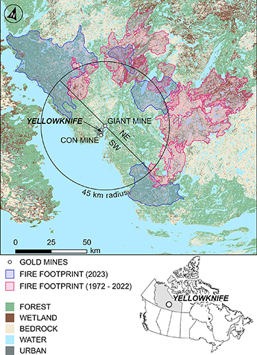
Figure 1. Map of Yellowknife, NT region study area on the north shore of Great Slave Lake, depicting land cover, wildfire footprints, and 45 km radius from Giant Mine, the main source of anthropogenic arsenic to the area. Due to the uneven proportions of wetlands in the fire footprints, two fires were responsible for the majority of wetland disturbance (ZF062-73 in 1973 and ZF029-98 in 1998).
Download figure:
Standard image High-resolution imageSeventeen fires have occurred on the north shore of Great Slave Lake since 1972, burning 6100 km2, with approximately 2500 km2 (41%) attributable to the four fires that occurred in 2023. The majority of historic wildfires occurred outside the 30 km radius that represents the approximate boundary of elevated anthropogenic arsenic determined by Palmer et al (2021) (figure 1). Only three fires before 2023 (1998, 2014, and 2019) were within the 30 km limit and may have released anthropogenic arsenic, while three of the four fires in 2023 were within this 30 km limit and encroached on the city of Yellowknife and the mine-impacted soils (figure 2). For some distances from the mine center, nearly all of the vulnerable arsenic has been impacted by wildfire from 1972 to 2023 (figure 3). For example, between 52–54 km from Giant Mine 99% of all surface soil was burned during the study period. When considering all wildfires, near-surface soils containing up to 990 Mg of vulnerable arsenic have been impacted by fire since 1972, with 420 Mg of this arsenic disturbed in 2023 alone. Over the last 51 years, wetland soils stored 37% of the vulnerable arsenic that was impacted by wildfire, despite occupying only 14% of the land area. The estimated proportion of arsenic emitted to the atmosphere for upland soils varied between 7 and 12%, resulting in total upland emissions of 44–75 Mg (figure 4). A larger range in peat emission efficiency, from 5%–84%, resulted in far greater bounds to arsenic emissions from wetlands (17–306 Mg). When combined across all landscape types, estimated atmospheric arsenic emissions from wildfires were between 61–382 Mg, with 28–111 Mg attributable to the four wildfires in 2023. In contrast, estimated arsenic emissions from aboveground biomass combustion amounted to only 0.6–0.7 Mg since 1972.
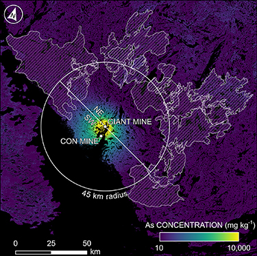
Figure 2. Soil arsenic concentration surrounding Yellowknife, NT based on a relationship between proximity to Giant Mine, position relative to the mine, and landcover type derived from Palmer et al (2021).
Download figure:
Standard image High-resolution image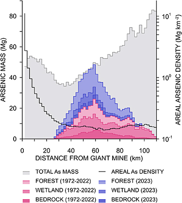
Figure 3. Total vulnerable arsenic mass held in the near-surface layer as a function of increasing distance from Giant Mine plotted in 2 km increments. Also shown is the maximum potential arsenic mass released from fires in 1972–2022 and 2023, by landscape type. Mass is a function of areal arsenic density and total area, which increases with successively larger distances (radii) from Giant Mine.
Download figure:
Standard image High-resolution image
Figure 4. Cumulative high and low estimated fluxes of arsenic to the atmosphere and water since 1972.
Download figure:
Standard image High-resolution imageThe estimated water mobilizable fraction of arsenic varied between 0.12–0.15 for upland soils, and 0.02–0.23 for wetland soils. Mobile arsenic released from upland soils between 1972–2023 was estimated between 73–96 Mg. Similar to atmospheric emissions, water mobile arsenic from the combustion of wetland soils has a large associated range of 7–85 Mg, depending on the wildfire temperature. Before 2023, the total water mobile arsenic potentially released from near-surface soils was 39–109 Mg, while in 2023 alone the arsenic that was potentially water mobilized was estimated at 41–72 Mg. These estimates do not account for potentially eroded material, which, given that up to 65% may be lost from uplands following wildfire (Markle et al 2020), represents a large unaccounted potential flux of arsenic.
Using the lower estimates of wildfire-mediated arsenic emission and water mobilization there are only minor differences between wetland and upland arsenic release when standardized by area (figure 5(a)), with wetlands acting as marginally smaller arsenic sources. Yet, by applying the upper estimate of arsenic release and assuming a regime of enhanced wildfire severity (Wilkinson et al 2023), wetlands act as immense sources of arsenic, particularly in close proximity to Yellowknife (<15 km) but even outside the radius of legacy arsenic contamination (figure 5(b)).
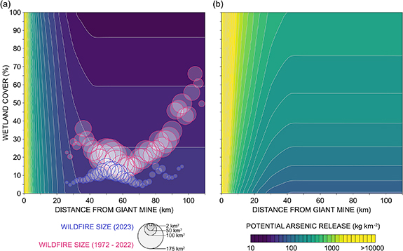
Figure 5. Conservative (low release scenario) past (a) and worst-case (high release scenario) future (b) arsenic releases to the atmosphere and water as a function of distance from Giant Mine and proportion of wetland cover. Panel (a) is complemented by recent and historical wildfires plotted in the phase-space proportionally to the area burned. Panel (b) assumes greater fire severity in the future of 1.5 kg C m−2 (Wilkinson et al 2023).
Download figure:
Standard image High-resolution image4. Discussion
Decades of gold mining and smelting in Yellowknife, coupled with naturally arsenic-rich bedrock (Palmer et al 2021), has led to an accumulation of ∼2950 Mg arsenic in the wildfire vulnerable soils within the study region (figure 6). The high arsenic concentrations in the wildfire vulnerable soils (Palmer et al 2021) and biomass (St-Onge 2008) led to an estimated 141–562 Mg of arsenic released to the landscape over the last 52 years, a globally significant release. Given the abundance of wetlands in this landscape, atmospheric arsenic emissions from represent the largest release pathway when wildfire temperatures are high (84%). In contrast, vulnerable arsenic that would be eroded or mobilized as dissolved arsenic was proportionally higher under lower fire temperatures (23%), which may be more likely given the propensity for smoldering peat fires (Thompson et al 2015, Huang and Rein 2017). The extreme wildfire year (2023) highlights the major vulnerability of this region to potentially catastrophic arsenic release, where 69–183 Mg arsenic were potentially released from just four wildfires: equivalent to ∼0.5%–1.0% of global annual industrial arsenic production (Deschamps and Matchullat 2011). Moreover, considering that these four wildfires represented only ∼6.0% and ∼1.5% of the area burned in Northwest Territories and Canada, respectively in 2023, these potential releases have staggering implications for understanding arsenic cycling in northern landscapes. However, there has yet to be a comprehensive wildfire arsenic budget, representing a significant gap in our knowledge.

Figure 6. Conceptual diagram of wildfire induced-fluxes and soil stores of arsenic within 110 km of the Giant Mine, Yellowknife. The arrows are approximately proportional to the magnitude of the flux or store.
Download figure:
Standard image High-resolution image
Wildfire-induced changes in water-extractable or eroded arsenic can have detrimental health impacts on communities and ecosystems (Chappell et al 2003, Zhang et al 2009). With lower temperature wildfires, the proportion of water-mobilized arsenic, either eroded or extractable, increases relative to atmospheric emissions. Despite the smaller amount of arsenic potentially released in our low-release wildfire scenario, we estimate that the local landscape will receive as much arsenic during a given wildfire year (∼18 ± 24 Mg) as all other unintentional industrial arsenic releases to soils and water (∼18 ± 44 Mg) across Canada (Environment and Climate Change Canada 2022). Comparatively, our high-release wildfire scenario estimates for 2023 are between 0.1%–1% of global anthropogenic releases to soils and water (Chilvers and Peterson 1987, Deschamps and Matchullat 2011). A larger area of uplands burned than wetlands and represented 79 ± 16% and 33 ± 16% of the total water mobilized arsenic in the low and high scenarios, respectively. The upland-derived arsenic will either be deposited into downgradient wetlands or surface waters but its eventual fate in surface waters is highly uncertain due to the diversity of potential arsenic species (i.e. bioavailable, sediment-bound, precipitated mineral, etc.) (Johnston et al 2019, Chen and Costa 2021, Pennino et al 2022). Post-wildfire elevated dissolved arsenic concentrations in surface water and groundwater are often elevated above drinking water guidelines across the continental United States (Emelko et al 2011, Bladon et al 2014, Murphy et al 2020, Pennino et al 2022). In the Taiga Shield, water in the uplands often runs off into low-lying wetlands (Spence and Woo 2003, 2006), where arsenic can accumulate or transform to more bioavailable or mobile species (As(III) and organic-arsenic) due to the reducing conditions (Mikutta and Rothwell 2016). The additional post-fire upland arsenic input, coupled with large increases in water-soluble arsenic species following wetland fire (Li et al 2023), may result in a significant source of (bio)available arsenic to surface waters after wildfires. The combination of direct arsenic-rich runoff and erosion from uplands and the runoff directly from wetlands may pose a significant threat to regional drinking water quality and have potentially disastrous cascading consequences on aquatic ecosystem services (e.g. Robinne et al 2021).
Unlike unburned landscapes where dissolved arsenic is a predominant release mechanism (Rothwell et al 2007, Deschamps and Matchullat 2011), wildfires in wetland-rich landscapes release a large proportion of arsenic into the atmosphere. While the EF from biomass burning and mineral soils is similar (table S1), there are fundamental differences in wildfire behavior in burning organic soil wetlands (Li et al 2023). The smouldering wetland fires driven by moist organic soils results in a large PM2.5/10 emission (Hu et al 2018) that is correlated with high TMM concentrations (See et al 2007, Betha et al 2013, Jayarathne et al 2018, Das et al 2019), including arsenic, driving arsenic emissions to the atmosphere in this landscape. We estimate that median arsenic emissions per wildfire in this landscape vary between 2 ± 5 Mg (low scenario) and 12 ± 31 Mg (high scenario), which is equivalent to ∼5%–31% of all annual unintended atmospheric arsenic releases in Canada (Environment and Climate Change Canada 2022). Our low-end approximation of arsenic emission represents a conservative estimate since it exclusively accounts for arsenic in PM2.5 (Lestari et al 2024). Globally, Nriagu (1989) provided the only estimate of forest fire arsenic emissions of ∼190 Mg yr−1 based on arsenic released during biomass combustion. In 2023 alone, our estimated atmospheric release from soils was between 15 and 59% of the global annual arsenic wildfire emissions from just four wildfires covering ∼2500 km2. Moreover, the 2023 wildfires likely represented between 2 and 9% of all global atmospheric arsenic emissions from all natural sources (Nriagu 1989). The globally significant emission of arsenic highlights the vulnerability of TMMs release in contaminated soils, whether of natural or industrial origin, that were thought to be long-term arsenic stores. More importantly, we show that global estimates of natural arsenic emissions to the atmosphere from wildfires are likely underestimated.
Within our five-decade wildfire record, no major wildfire was within 15 km of the historical Yellowknife smelters. Yet, within those 15 km, there is the highest arsenic density in both wetland and upland soils (figure 5(a)) and the total mass of arsenic in the soils is not matched until >40 km away when the increasing area of incrementally larger radii compensates for the differences in arsenic soil density (figure 3). Even under our low-release scenario, an average wildfire (∼444 km2) within 15 km has the potential to release more arsenic than even the largest wildfire on record due to these differences in arsenic density. Approximately 12%–18% of the remaining vulnerable arsenic is within these soils. The large amount of vulnerable arsenic in just the upper 10 cm of upland and wetland soils may present a significant risk to the local communities and ecosystems (figure 6). Given that fire suppression over the last several decades has increased the flammability in the wildland-urban interface in Canada's boreal region (Parisien et al 2020), the potential for wildfire disasters around Yellowknife and other legacy industrially-contaminated areas in the boreal are very high (e.g. Erni et al 2024).
The hotter and drier conditions induced by climate change are projected to increase both fuel connectivity, area burned and burn severity in wetlands (Turetsky et al 2015, Thompson et al 2019, Wilkinson et al 2023) and forests (Wotton et al 2017, Ellis et al 2022). These drier conditions can increase burn depths up to 1 m in organic soil wetlands (Lukenbach et al 2015, Walker et al 2019), which is 10x deeper than used in our estimates. While research on the effect of climate change on wetland wildfires has largely focused on the loss of this deeper old carbon (e.g. Turetsky et al 2015, Wilkinson et al 2023), increasing the depth of burn also increases the potential to mobilize a proportional amount of natural and legacy arsenic from the wetland soils surrounding Yellowknife (figure 5(b)) and globally for TMMs in other regions similarly threatened by wildfire. Under a 'worst-case' scenario with deeper burns and high EFs, fires within this region at all distances from the mine have the potential to release more arsenic than any fire on record. While the interaction between the deeper wetland burns, increased burn area and severity suggest that the 2023 wildfire year potentially represents future arsenic release, it may be a mere glimpse of what is to come as our climate increasingly warms.
5. Summary and conclusions
This research is the first quantification of a potentially globally-significant release of arsenic by wildfires and highlights the important role of wildfire temperature and soil type on arsenic mobility and likely (bio)availability. Our estimated atmospheric release from just four wildfires near Yellowknife in 2023 was between 15%–59% of global annual arsenic wildfire emissions. This work clearly demonstrates that regions with contemporary or historical mining and smelting or those with naturally high TMM soil concentrations around the globe are also vulnerable to significant TMM releases, particularly under an increasingly warm and dry climate. We recognize that there remains limited information in the literature with which to derive more precise estimates, resulting in a large range of potential arsenic releases. The complex interactions between arsenic, wildfire, and environmental conditions have not been fully explored and our estimates do not necessarily represent the natural variability in this landscape. As such, there needs to be a concerted effort to experimentally understand these feedbacks at the laboratory and landscape scales. We reiterate the call of McCarter et al (2023) for a coordinated and collaborative effort by wildfire scientists, soil scientists, (bio)geochemists, atmospheric chemists, and health scientists to unravel the past, present, and potential releases of not only arsenic but all TMMs from industrially-contaminated landscapes. We especially advocate for a nation-wide wildland-urban interface wildfire TMM release risk mapping assessment (e.g. Erni et al 2024). Mapping wildfire TMM release vulnerability would require the integration of current spatially-explicit soil TMM concentrations, knowledge on TMM chemical speciation and pyrogenic effects on speciation under different environmental and soil mineralogy conditions, while linking current and future depth of burn through hydrological modelling or by using Fire Weather Indices as a proxy (e.g. Thompson et al 2019). Such efforts are crucial to better understanding, quantifying, and mitigating the risk these releases may pose to human and environmental health.
Acknowledgments
Funding for this research was provided by the Canada Wildfire NSERC Strategic Network, an NSERC Alliance Mission Grant to CPRM, and a McMaster University Faculty of Science Global Solutions Initiative (GSI) to J M W. Additional support for this research has been provided by the Canada Research Chairs program to C P R M and J M W. We thank Gareth Clay, Emma Shuttleworth, Scott Davidson, Sophie Wilkinson, Scott Smith, Nick Kettridge, Karen Kidd, Alex Furukawa, Guillermo Rein, and Emma Sherwood for many valuable discussions during a GSI workshop. We also thank Dr Xiao Li for providing the source data for Li et al (2023). Lastly, we thank three anonymous reviewers whose comments and suggestions strengthened this manuscript.
Data availability statement
All data that support the findings of this study are included within the article (and any supplementary files).
Author contributions
Sutton: Data curation, Formal Analysis, Investigation, Methodology, Software, Visualization, Writing—original draft, Writing—review & editing
McCarter: Conceptualization, Formal Analysis, Investigation, Methodology, Writing—original draft, Writing—review & editing, Funding acquisition
Waddington: Conceptualization, Writing—review & editing, Funding acquisition
Conflict of interest
The authors declare no competing interests.
Supplementary data (<0.1 MB DOCX)