Abstract
Traveling and recording the adventures lived abroad in travelogues was a common practice among European aristocrats in the eighteenth century. The travel journals are filled with descriptions of the places they visited, but also with characterizations of their impressions and emotions evoked by historical landmarks. This paper aims to explore the sensations of northern and central European travelers to investigate the identity and sense of place of Cyprus, as experienced by the travelers, through deep mapping. The exploration of impressions focuses on seven categories: places, points of interest, people, hospitality, accessibility, landscape, and food/drinks. The impressions expressed by words in the travelogues are coded in a five-point scale to be able to obtain statistics from the geodatabase created in GIS. The result is a bunch of maps that show the diverse level of pleasantness according to the various places and historical landmarks visited. Moreover, this paper demonstrates the importance of combining quantitative and qualitative data through digital tools in archaeological and historical research.
Introduction
The definition of deep map is not univocal: we may say that there is not one definition, but several explanations of the concept represented by deep map. Deep map wants to tell the many different stories of a place as experienced by people, and thus it represents subjectivity. The aim of deep map is not the narration of universal truth, but opening to new conversations (Bodenhamer 2015; Harris 2016). It is an instrument of observation, analysis, inquiry, and interpretation (Donaldson 2020) that most of the time instead of finding answers leads to new sociocultural questions (Engel 2018), offering the opportunity to deeply think about the identity of places. Practically speaking, what we need for creating a deep map is the spatial representation of the place we want to investigate, and a series of data related to that place, both quantitative and qualitative. Moreover, images, texts, virtual representations, and audio can be added to enhance and strengthen the story we would like to narrate. GIS, which has been largely used by archaeologists since the 1980s for spatial analyses, is a valid instrument to develop a deep map. Some interesting examples of deep mapping applied to humanities concern the narration of social transformation of an archaeological site in New Mexico (Worthy 2015), of historical landscape in the English Lake District (Reinhold et al. 2018), and of the emotions in Victorian novels set in London (Heuser et al. 2016). I consider the latter particularly relevant because the investigation of emotions through deep mapping is something useful for the comprehension of the essence of a place. Emotions and places are intrinsically tied, there is a kind of mutual relationship between the two. The appearance of a place, what is contained in it (buildings, vegetation, landscape, food, people), raises impressions, or emotions, in the people living there, or visiting. According to the emotions evoked, the people react in a certain way that influences the place itself. Ideas and opinions take shape in people’s head according to their impressions, and they affect the places. Both good and bad impressions contribute to the construction of the sense of place, which also indicate its distinctiveness (Foote and Azaryahu 2009); this is why it is fundamental to consider the emotions a place evokes to investigate its identity, and consequently ours, because as Eudora Welty (1990:119) said “place has a more lasting identity than we have, and we unswervingly attach ourselves to identity.” It is thus intriguing combining deep mapping and emotionology. The latter is a subfield which has been gaining popularity in history studies in the last 20 years. Its aim is to investigate the evolution of emotions and their expressions throughout centuries and different societies, by means of different approaches (Barclay 2020). The application of emotionology in archaeological contexts is scarce, but there are scholars who are trying to encourage its implementation (Marchant 2017; Millingan 2021; Tarlow 2000, 2012). The same can be said for the application of deep mapping in archaeology. Despite it is a concept that has been briefly debated by few experienced archaeologists (Gillings et al. 2019:4–5, 9; Pearson and Shanks 2001:64–65, 162), practical examples are still rare (Earley-Spadoni 2017; Lewis 2015; Millingan 2021; Pettitt 2021). The main critical aspect of deep mapping in archaeology is its subjectivity and the lack of an established methodology, but it can enable a deeper understanding of the sites adopting a holistic approach. Through deep map we can explore the symbology and the cultural reasons behind the historical development of places. In archaeology, we are used to applying logical explanation to discoveries, we look for the practical use of something, but we forget too often that memories, emotions, and perceptions contribute greatly to the shaping of places and their identities, as Christopher Tilley (1997) explained for the implementation of the phenomenological approach.
The aim of this paper is indeed to map the impressions eighteenth-century European travelers experienced in Cyprus, described in their travelogues, with a particular focus on the historical landmarks (antiquities, monasteries, churches, castles, and mosques). The comparison of the impressions/opinions of different travelers about various categories may help understanding the sense of place of Cyprus in the eighteenth century, and the role played by historical landmarks in the perception of local identity by Europeans. The paper focuses on the travelers of the eighteenth century because this is the time when the Grand Tour phenomenon reaches its peak. Numerous males (and more rarely females) from the aristocracy (above all British, but also from other European countries) began undertaking their educational journey around Europe since the second half of the seventeenth century. Their main purpose was to learn the rules of European high society, and thus they spent time in Paris, Turin, and other principal cities. Apart from this, such trips were characterized also by the personal interests and curiosity of the travelers. In particular, in the eighteenth century, antiquities exercised a strong allure, above all after the discovery of Herculaneum in 1738; indeed, the principal destination during the Grand Tour was Rome. Concurrently to the strengthening of antiquarian interests, the first theories on aesthetics started developing thanks to philosophers like John Locke, David Hume, and Francis Hutchenson. These philosophers claimed that physical senses and perceptions were fundamental to understanding beauty. The combination of these aspects raised my curiosity about the impressions European travelers could have of the most eastern island of the Mediterranean, rich in antiquities, scenic beauties, and wildlife, but ruled by the Ottomans, considered the enemies of the Christian Europe. Even if the island of Cyprus was not part of the Grand Tour itinerary, the travelers who visited the island often belonged to the same cultural context. The analysis of their impressions through deep mapping can give us insights about the role antiquities, historical landmarks, and wildlife had in shaping an idea of the place in the mind of foreigners. The importance of focusing on travelers’ witnesses is that their travel journals were largely spread around Europe and their impressions and opinions could influence the mentality of many European citizens.
Cyprus and Travelers in the Eigteenth Century
The island of Cyprus is in the far eastern area of the Mediterranean Sea. Its history has always been characterized by cultural and economic exchanges between the West and the East; as a consequence, often the island was occupied by external powers. Cyprus offers a rich archaeological panorama demonstrating a long and ancient human occupation of the island. The first archaeological traces are dated back to the tenth century BCE (Hadjidemetriou 2018:12). There are numerous remains that witness the archaeological value of the island from the Neolithic till the Roman times, then followed by the Byzantine, the Frankish, the Venetian, and finally the Ottoman rule. Scientific investigation to understand the history of the island have started in the early twentieth century, even if, as it happened in several archaeological areas of the Mediterranean, already the century before was characterized by excavations aimed to find precious objects (Karageorghis 1968:22–24; Pilides 2012). Antiquities and historical landmarks of Cyprus were also mentioned (and sometimes drawn), even if often surprisingly roughly, in travel journals from the previous centuries (Chatzipanagiotoi-Sangmeister et al. 2023). In the last 20 years, the presence of foreigners travelers in Cyprus have started sparking interest (Arkan 2021; Gibson 2022; Gilet 2005), even if studies are still rare, and a deeper and systematic approach is still missing.
All these characteristics make Cyprus a fascinating place to examine, above all in consideration of the relationship between East and West, the Eastern Question, and its role within Europe. The concept of European identity is, among other things, based on the differences with other geographical and, above all, cultural areas, but did the travelers really experience such contrast? In which way? And how did they narrate their understanding of the places explored?
This paper considers seven travelogues dated between 1700 and 1788 which emphasize some of the ancient sites of the island, together with other historical landmarks. The choice of these documents was made considering several aspects. Even if the European visitors to the island were numerous (above all pilgrims, diplomats, and merchants), not everyone wrote about their personal experiences and impressions. Some of them decided to write about the history of the island, or general information, rather than expressing their perceptions, as in the case for instance of the Dutch travelers Johannes Aegidius van Egmont and John Heyman. Therefore, the selection of the travelogues depends on the presence of subjectivity and witnesses about the material heritage among their pages. Furthermore, part of the methodology used here is based on a close reading approach, which does not allow to quickly analyze numerous texts because of time/human limits. The selection of the travelogues is intended to be enlarged in the future to improve the results of the research (for instance, currently, the travel journal of John Montagu Earl of Sandwich is being examined). Also, the intent was to create a selection of travelers of different nationalities (rather than only British as it often happens in such kind of studies) to consider a wider European perspective. Lastly, the selection was also made according to the time when the travels happened, that means the eighteenth century because of the raising interest in antiquities and aesthetics in that period.
In 1571 Cyprus was conquered by the Ottomans. The eighteenth century was characterized by plague and other diseases, famine, political turmoil, high taxation (in particular for non-Muslims), privateers, and the resulting escape of numerous citizens (Hill 1952:67–99). Therefore, travelers arrived in a place that showed signs of hardship, and indeed they often remarked on the sense of decline they experienced. They also did not miss the chance to blame the irresponsible politics of the Ottomans for that, but also the Greeks for their inanition, as we can read in Drummond’s (1754:141) account: “innate indolence and laziness of the people, the insecurity of the property, and the supine negligence of the minister of the Porte, whose whole care is employed in keeping their wives from the eyes of other men, and in extorting money in the most oppressive manner from those who groan under their despotic sway.” Despite this, the eighteenth century saw an increase of foreigners’ business for the raw materials of the island (cotton, silk, wine, and oil), thus the presence of European merchants became steadier (Hadjianastasis 2009:77–78).
Eighteenth-century Cyprus has been studied by several scholars in order to understand its social, economic, commercial, and political characteristics, and how these were influenced by the Ottoman rule (Demiryürek 2018a; Hadjikyriacou 2011, 2014; Stavrides 2009, 2012). This paper will focus more on the perceptions the European travelers experienced visiting the island, and the impressions they decided to narrate in their travelogues, in particular to understand the role that different historical landmarks of the island played, and the impact of the Ottoman rule.
The seven travelogues elected so far to do this research are representative of the impressions of three British, two Italians, one Dutch, and one Swede. They travelled to Cyprus for different reasons: business, politics, wildlife, antiquities, and sake of exploration. They were on their thirties (of two of them we do not know their birth date) when they travel to Cyprus, and they were all coming from quite wealthy families. All of them extended their journey to the Levant, Turkey, or Egypt.
At the end of the seventeenth century, Cornelis de Bruijn, a Dutch painter who traveled frequently to numerous destinations, visited Cyprus. He lived in Italy for many years, he visited Russia, Asia Minor, Near East, and Persia. Together with his travelogue, he left drawings of what he could observe in the areas he explored. He went to several places in Cyprus in 1683, and in its travel journal (De Bruijn 1700) he mentioned some others as well that does not seem he really visited. The latter were not considered in the research since the focus is on the experience of travelers.
Three of the travelers considered in this research visited Cyprus in the first half of the eighteenth century. The first one was Charles Thompson, a British merchant who decided to travel across Europe and Near East moved by an instinctive curiosity. He left Rhodes to reach Cyprus (Famagusta) in February 1734, but he departed immediately for Syria. He talked about the history of Cyprus in his travel journal (Thompson 1813) (which soon became very popular), but he did not have the interest to explore the island. Of a different kind is the travel account of Richard Pococke, a British churchman who studied law, but was fond of anthropology. He toured Europe and the Near East for a long time. His travel journal (Pococke 1745) presents detailed descriptions of archaeological remains, plus comments about the people and the societies of the places he visited that often look biased. The travelogue by Alexander Drummond is quite informative too. He was a Scottish consul who travelled to Italy and Asia Minor. In 1745, he toured Cyprus quite extensively and he was particularly interested in people, buildings, animals, and plants. His travelogue (Drummond 1754) contains numerous descriptions about several aspects of the island, and it is evident his disdain for the Ottomans in Cyprus.
The remaining three selected travelers visited the island in the second half of the eighteenth century. Frederick Hasselquist was a Swede naturalist who travelled to the Near East. Even if he stopped in Cyprus only briefly in 1751, he did narrate his impression of the island in his travel journal (Hasselquist and Linné 1766). On the contrary, Giovanni Mariti sojourned on the island for a long time. He was coming from Italy; he had several interests, such as literature and natural science, but we can consider him as an antiquarian for the strong passion he demonstrated in describing the archaeological remains during his journey. He spent eight years in Cyprus (from 1760 to 1768), he traveled around the island, and his travelogue (Mariti 1769) gives a general idea about the current state of the places. His descriptions are particularly interesting because he narrated what he saw without being judgmental. Finally, another Italian reported his journey to Cyprus. Domenico Sestini (1788) was an antiquarian who discovered his passion for antiquities during his trip to Sicily. He undertook long journeys, and on his way to the Near East, he quickly stopped in Cyprus where he visited few cities and saw several remains that he described in his travel journal.
Methodology
Initially, a selection of travel journals was made. Since the main aim of the research is the investigation of the impact of antiquities and historical landmarks on the island, the scope was to collect diaries of travelers who were particularly interested in antiquarianism. Nevertheless, Cyprus, in the eighteenth century, was mainly considered as a stopover for the Near East, where Europeans used to travel as merchants, consuls, or explorers. Anyway, some of them described their experience on the island, even if it was a short one, and their travel journals have been considered worthy of being included in this research. So far, a limited number of diaries have been collected, but more of them will be enhancing the deep map in the future. Two travel journals are from two Italian antiquarians (Giovanni Mariti and Domenico Sestini), one from a Dutch artist (Cornelis de Bruijn), one from a Swedish naturalist (Frederick Hasselquist), one from a British anthropologist (Richard Pococke), one from a British consul and merchant, (Alexander Drummond), and one from a British merchant (Charles Thompson), for a total of seven travel journals.
Each travelogue was read thoroughly, by means of a close reading approach, focusing on adjectives and periphrasis which describe both positive and negative impressions and emotions of the travelers exploring the island. Although distant reading could provide a much larger amount of data to analyze and to build the deep map, it was not considered as a good option to examine subjectivity. In such cases, it is important to understand the shades in the style of the author to well comprehend her/his intentions and the meaning she/he attributes to the words. This research does not aim to search only for the places or monuments visited, in which case the distant reading could be advantageous, but it focuses on the personal experience of the travelers. In particular, the investigation involves subjective comments about points of interest (antiquities, churches, monasteries, mosques, castles), places (towns and villages), landscape, people, hospitality, food, and accessibility. The positive and negative words and periphrases used to depict these categories were initially noted on an Excel file to organize the elaboration and the compilation of the geodatabase in GIS. The descriptions recognized by the author of this paper as subjective expression of the travelers’ experience needed to be coded to be conveniently implemented in GIS. A five-point scale was formulated for each one of the categories mentioned above. Each group of words corresponds to a number from 1 to 5, according to the level of pleasantness experienced by the travelers. The five-point scale conceived for both historical landmarks/antiquities, and places is: enthusiastic (5), good (4), average (3), bad (2), disappointing (1); the one for the people is: remarkable (5), pleasant (4), average (3), unpleasant (2), despicable (1); the one for food and drink is: excellent (5), good (4), average (3), bad (2), disgusting (1); the one for landscapes is: thrilling (5), pleasant (4), average (3), unpleasant (2), dreary (1); the one for hospitality is: very welcoming (5), welcoming (4), average (3), unwelcoming (2), very unwelcoming (1); the one for accessibility is: enjoyable (5), easy (4), average (3), difficult (2), dangerous (1). The attribution of positive/negative words to each point of the scale is the first interpretative process made by the author after reading the texts. An extensive table containing the words used by each traveler corresponding to each number of the five-point scale for each category has been created, and it will be published in a suitable venue for the sake of transparency.
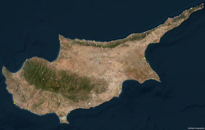
The first step in GIS was the localization of both places and points of interest on the map (Fig. 1). Afterward all the values of the five-point scale related to each place and to each landmark were added according to each traveler’s opinion. The located places in the island of Cyprus that are mentioned in the analyzed travel journals are 87, and to these are connected the comments about general impression, people, food, hospitality, accessibility, and landscape. The points of interest (antiquities and historical landmarks) visited by the travelers and located on the map are 94. The distinction between places and points of interest is fundamental if we want to consider the role that historical landmarks played in the travelers’ experience.
The attribute table of the point geographical feature “places” is characterized by the following fields: name (Nicosia, Larnaka, etc.), coordinates, and place_ID. The attribute table of the point geographical feature “points of interest” contains the following fields: place, name (e.g., Tomb of the Kings, temple of Zeus, etc.), coordinates, type (antiquity, church, mosque, fortress, monastery), accuracy (certain, uncertain, unknown), date, and point_of_interest_ID.
Stand-alone tables were also designed for adding information about specific contents. The “travelers” table contains the following fields: name, nationality, year of birth, education, interests, title of the travelogue, start year (of the journey), end year (of the journey), traveler_ID.
The information above listed (about the feature classes and the stand-alone table) was selected to allow the production of analyses that can help in the comprehension of the general context. It may be relevant to know the education, or the interests, of a traveler when considering his (so far, no women’s diaries were collected) comments about antiquities; or it may be useful to conduct research about the impressions related to the dates of the historical landmark, or to the type, to verify if there were preferences.
Two more stand-alone tables comprehend the traveler’s opinions. One is the table with the impressions (indicated through the five-point scale) of each traveler about places, people, hospitality, landscape, food, accessibility; the fields include the traveler_ID and the place_ID. Another table contains the impressions of the points of interest for each traveler, still illustrated by the corresponding numbers from 1 to 5, and the fields include the point_of_interest_ID and the traveler_ID.
To be able to do relevant analyses, and to create valuable visualization map, the tables must be joined to the feature classes. Since the relationship is many to many, it was preferred to use the tool “make query table,” instead of the join, or relate, options. Two query tables were created: one formed by the “place” feature class, the table with the travelers’ impressions about the places, and the travelers’ table; another one by the “points of interest” feature class, the table with the travelers’ impressions about the points of interest, and the travelers’ table. These two query tables are the starting point to investigate the ideas the travelers had about specific places and specific points of interest.
The combination of all these data is what allows to create a deep map through mixed method approach which include quantitative and qualitative analysis, as it is usual in deep mapping. The different kind of analyses enabled by the diverse data contained in the geodatabase allow to deeply investigate the society of the travelers in a place, and to know their experiences, both emotional (impressions and opinions) and practical (visited places and interests). Other elements still need to be added, such as images or virtual reconstructions, but the intrinsic scope of deep mapping that is the study and representation of the history lived by people in a place is respected. This paper, for sake of conciseness and thematic coherence, only shows the emotional responses of the travelers for each above-mentioned category, but other analyses can be made according to the nationality, the interests, or the year of visit. Or also, according to the date and the type of historical landmarks. Deep mapping indeed, it is a never-ending exploration of a place.
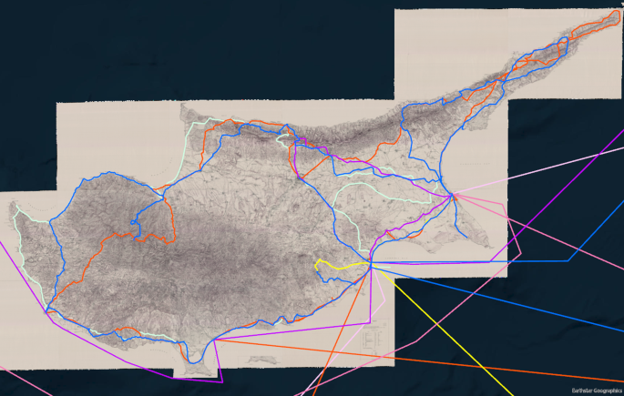
Linear feature classes were created to depict the itineraries of the seven travelers across Cyprus, from where they reached the island, and their next destination outside Cyprus (Fig. 2). The itineraries were built on the high-resolution georeferenced Kitchener’s map, provided by Professor Christos Chalkias from Harokopio University, and the Sylvia Ioannou Foundation. The attribute table of the “itinerary” feature class contains the following fields: “places” that is the town or village to which they headed; “date” when they stayed in that place; “company” (the persons, if any, they were accompanied by); “days” (how many days they spent in the place). Unfortunately, the last three above-mentioned information was not always trackable. Even the sequence of legs and stopovers are not always clear the way they are described in the travel journals: often, the illustrated itineraries are the result of interpretation made by the author according to the context and the general narration.
The last step of the methodological process was to create maps for visualizing the results of the investigation through Smart Mapping of ArcGIS online. This visual-thinking tool allows the selection of different styles to better interpret and communicate the analyses of the data. It gives the possibility to combine fields, apply filters, and add labels to the map, which are the most helpful options for this research. The combination of fields enables us to compare the impressions of the travelers about different categories. The filters are useful when we want to investigate something more specific, for instance the impressions of the travelers according to their nationality, or the year they visited the island, or the type of point of interest. The labels are useful to simplify the visualization of the map, for instance the name of the point of interest can be represented together with the impressions of the travelers about it.
Results
Through the creation and the visualization of maps representing the itineraries, and the various data contained in the geodatabase, we can examine the information collected, and attempt an initial reconstruction of the interests and impressions of the travelers of the eighteenth century in Cyprus.
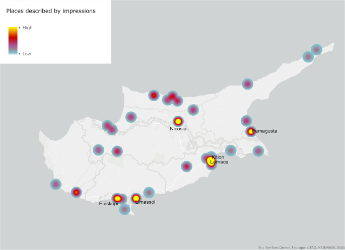
Figure 2 shows that the travelers chose mainly to visit the coastal area of Cyprus, but only two of them (Alexander Drummond and Richard Pococke) went almost all the way around the island. Giovanni Mariti as well visited the coast extensively, including Akamas peninsula, the northwestern area of the island, but excluding the northeastern side. Figure 3 is the heatmap, which illustrates the places described in relation to personal impressions by the travelers through a scale of color that goes from yellow to gray: the places with the highest number of comments is represented in yellow, the ones with the lowest number of comments are gray. The map on GIS can be easily interrogated to discover more about the specific areas/points. It shows that the most commented place was Famagusta (with impressions reported by six different travelers), that was one of the main harbors of the island and a Venetian fortress; located in the southern east coast, it was considered the “Emporium of the East” (Jeffrey 1983:102). After Famagusta, Larnaka, another important harbor on the south coast, and seat of several European consulates, was the place with the most comments reported (five). The same number of impressions is recorded for Kition, an Early Bronze Age (2300 − 2000 BCE) settlement characterized by destructions and reoccupations till the Roman time (Callot et al. 2022). Another harbor on the south coast of the island, Limassol, was among the most commented places (with four impressions). Nicosia as well, that was already the capital of Cyprus, was described in four impressions. Three travelers expressed their perceptions about Episkopi which was a large village that in Medieval times was the fief of the Ibelins, and in the fourteenth century become a property of the Cornaro family from Venice (Jeffrey 1983:378). Surprisingly, Nea Paphos is not among the most commented places (only Mariti described its impression) despite its role of ancient capital of the island when Cyprus was a Roman province, since 22 BCE, and its important archaeological remains dated to the Hellenistic and Roman times (Balandier 2016; Christou 2008). The same can be stated about Salamis, another Roman site, with relevant archaeological remains (Rogge et al. 2019); only Pococke reported its impression there. The only archaeological site that received a decent number of impressions is Kition, but it may be because of its proximity to Larnaka. The heatmap shows that probably the main interest on the island for European travelers was a commercial one. The area of the mountain chain of Trodoos and its surroundings, was almost completely neglected by the travelers, except for Kakopetria where there is the Monastery of Agios Nikolaos of the Roof, and the area of Kykkos Monastery, both dated to the eleventh century (Megaw 1974:88–89; Roudometof and Michael 2010; Stylianou and Stylianou 1997:53–75).
Arrivals and departures to and from the island happened from the towns on the south and east coast: Limassol, Larnaka, and Famagusta. The travelers were coming, or going, from, and to, the most diverse places outside Cyprus: Greece, Turkey, Egypt, Syria, and Lebanon.
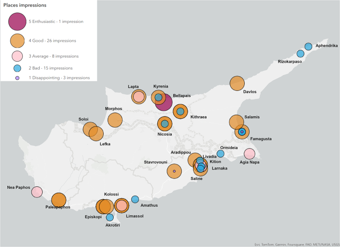
A different type of map represents the impressions of the travelers for the several categories considered (place, point of interest, landscape, food, hospitality, people, accessibility). These maps are characterized by circles of different colors and sizes that, as shown in their legend, indicate the five-point scale representing the level of appreciation from 1 to 5, and the number of impressions that each place and point of interest received.
The map representing the impressions about the category “place” shows 53 impressions for 64 places (Fig. 4), this means that not all the visited places (which are 87; see Fig. 1) raised the interest of the travelers. It reveals that most of the places generated a good sensation (1 description used adjectives corresponding to 5-enthusiastic, and 26 to 4-good). However, several places also provoked negative feelings: 15 impressions correspond to 2-bad, and 3 to 1-disappointing. We can notice on the map that the bad impressions are related to the areas on the southern coast (Akrotiri, Amathus, Saline, Larnaka, Livadia, Ormideia), and to the Karpas peninsula on the northeast side; while positive impressions are mainly located on the northern site of the island (Soloi, Lefka, Morphos, Bellapais, Davlos). Famagusta, Nicosia, Kyrenia and Kithraea are represented by contrasting opinions.
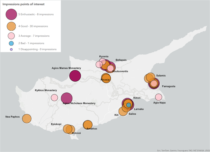
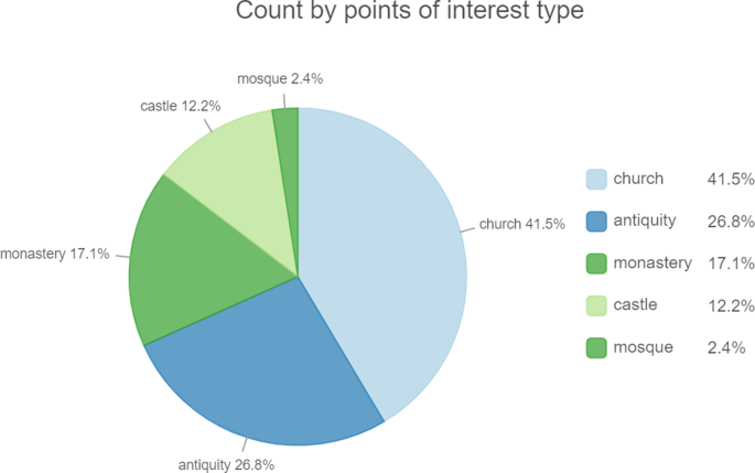
Analogously, the map of the impressions about the points of interest (antiquities and historical landmarks) (Fig. 5), which are 46 for 32 points of interest, illustrates a prevalence of good impressions: 8 belongs to the group 5-enthusiastic, and 30 to 4-good. There is only one bad impression (group 2), and 7 that are neither bad nor good (group 3). There are no impressions related to group 1- disappointing. In this case, we see that the positive impressions are spread around the island, demonstrating that the historical landmarks were endowed with a positive influence despite the scarce opinions about the surroundings, as the case of Amathus, Larnaka, Saline, and Famagusta. In particular, the enthusiastic impressions are related above all to the monasteries Agios Nikolaos of the Roof (eleventh century), Agios Mamas (eighteenth century), and Bellapais (thirteenth century), and the churches Agios Lazarus at Larnaka (ninth century), and Agios Nikolaos at Famagusta (fourteenth century). In addition, we can see in Fig. 6 that, indeed, more than antiquities, travelers used to comment on churches. I believe that this last aspect is meaningful considering the numerous archaeological remains of more ancient periods on the island, and the eagerness for Classical times during the eighteenth century. On the contrary, as shown in the chart, the cult places of Islam are not among the impressions expressed by the visitors, except for Hala Sultan Tekke at Larnaka, one of the most important mosques for the Muslims (Demiryürek 2018b); or mosques were mentioned with disdain for having replaced beautiful, older churches. Understanding the major interests of the European travelers can be helpful to know what they wished to stress about the island, what they want to defend, and what they want to condemn, probably because of ideological reasons behind, as for the eternal conflict between Christians and Muslims. This ideological motivation may be the reason for the tenuous interest demonstrated toward Classical, Hellenistic, and Roman sites as Nea Paphos (Balandier 2016; Christou 2008) Salamis (Rogge et al. 2019), Soloi (Westholm 1936), Kourion (Buitron-Oliver 1997; Swiny 1982), and Amathus (Hermary 2014), which could be expected to be the major attractions for European travelers of the eighteenth century.
Another aspect that would require major investigation is the evidence of strong contrasting feelings, as in the case of Stavrovouni which is characterized by one good and one disappointing impression, without any comments on the monastery built already in the fourth century; and Famagusta judged with good, bad, and disappointing words.
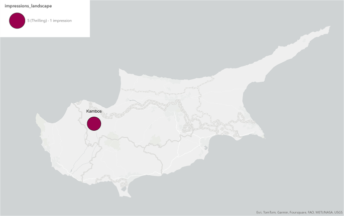
The travelers did not particularly dwell on the remaining categories, which seems another confirmation of the above-mentioned hypothesis. The landscape was described only once, at Kambos, with enthusiastic terms by Drummond (Fig. 7).
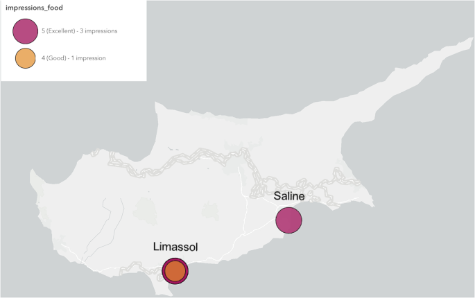
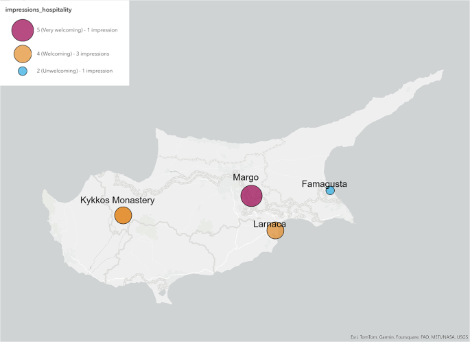
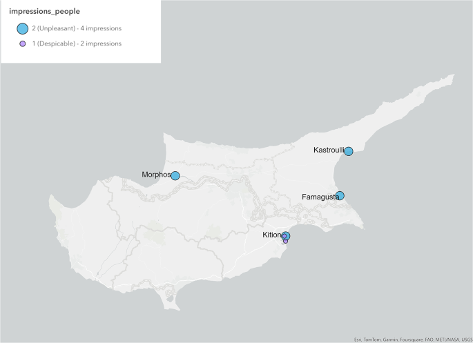
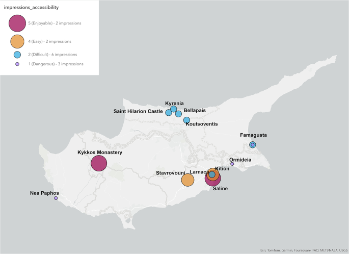
The impressions about food and drinks are only four, all of them very positive, and related to Limassol and Saline (Fig. 8). Comments on hospitality are only five, mainly good (at Margo, Larnaka, and Kykkos Monastery), except for one bad impression at Famagusta (Fig. 9). The opinions about people are limited to six; none of them are positive: the people of Kastroulli, Morphos, Famagusta, Larnaka, Kition, and Saline were considered unpleasant and despicable by the travelers (Fig. 10). Among the latter categories, accessibility is the one that received more comments: four are positive (about Kykkos Monastery, Saline, Stavrouvouni, and Kition), nine are negative (about Saint Hilarion Castle, Kyrenia, Bellapais, Koutsoventis, Famagusta, Ormideia, and Nea Paphos) (Fig. 11).
Overall, the good impressions prevailed in every category, except for accessibility and people, revealing the mostly positive experience the travelers had in Cyprus, despite the complaints about the Ottoman administration.
We can observe that there is no uniformity in the distribution of comments about the different categories. Only in a few cases, as Larnaka, Famagusta, and Saline, we find that they were mentioned in relation to more categories, but the large part of the sites is not illustrated under different aspects. It seems that every place had distinct characteristics that attracted the attention of travelers.
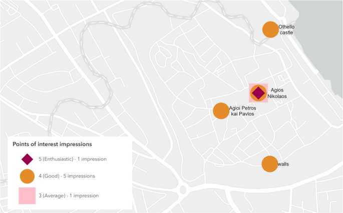
It is interesting to note that Famagusta often gave a poor impression to the travelers, except for the points of interest. In particular, the historical landmarks that had a positive impact are two churches: Agios Nikolaos (Walsh 2005), and Agios Petros and Pavlos (Walsh 2006), dated to the fourteenth century; and two defensive structures: the Othello castle dated also to the fourteenth century, and the venetian walls dated to the sixteenth century (Randall et al. 2014:10–24) (Fig. 12). The gloomy impressions might be due to the fact that after 1492 new commercial routes started developing across the Atlantic to connect Europe and America, leaving behind the once rich harbor of Famagusta and the links with the East (Maier 1968:115).
Discussion
The maps presented in the results section show the power of deep mapping. The possibility to visualize on maps the numerous and diverse information contained in the geodatabase eases the comprehension of specific geographical areas about well-defined topics. The power of visualization is the ability to group numeric, textual, imaginative information in a graphic form, which attracts the attention, enhances the concertation of the spectators, and at the same time enables the creator to narrate a story. Maps, indeed, can tell stories, and they can reflect the subjective interpretation of data. If our aim is the investigation of places, it would be probably convenient to always include maps as graphic representation of our findings, and as instrument for narrating the story we reconstructed through the research (Mocnik and Fairbairn 2018). Therefore, the benefit of deep map is twofold: it allows the examination of some characteristics of places through the selection, the combination, and the visualization of the data inserted in the geodatabase; moreover, it enables the narration of stories through its graphic representation, and its characteristic of storing, and displaying, the experiences happened in places. This paper shows different ways to represent our interests: different maps for the impressions about each category, sometimes marked with a diverse symbology as transparency, or different shapes and colors, and with the names of the places; a map with the names of the points of interest; a pie chart with the type of points of interest. The combinations of data, and their visualizations can be countless: they depend on what we are searching for, and which is the best way for us to find it. Another advantage of deep mapping is the possibility to enhance the geodatabase, and consequently to enrich the story of the places. For example, in the case of this research, the ambition is to expand the investigation of impressions of travelers to other Mediterranean areas, to have a wider picture of the idea northern Europeans had of southern and southeastern places. Also, to compare the different geographical areas in order to define any existing difference in their reputation and understand of what hypothetical distinctions depended.
The main aspect of a deep map is that it considers subjectivity and represents experiences. However, this can also be a limit. As already explained, part of the methodology of this paper consists in the codification of words, adjectives, and periphrases in numbers that express the level of positive and negative impact places had on the travelers. Numbers are fundamental because they enable the production of statistics, but the conversion of words (in particular terms that express impressions) into numbers is an oversimplification. Indeed, the codification process is a very crucial step, which involves the interpretative skills of the scholar. It is important to carefully read the documents whose words will be transformed into numbers in order to well understand what the writer meant to say. Relying on automatic detection of words offered by natural languages processing (NPL) systems is not always a good solution, despite the advancements in the field (Donaldson et al. 2017; Murrieta-Flores et al. 2015; Piao et al. 2009; Wiebe et al. 2005). Therefore, it is fundamental to note that the codification itself is subjective, and the result of an interpretative process. It would be useful to develop a standardization in the codification, which although would be possible only for the most common words.
Deep mapping also provides the opportunity to enhance research about emotions. It is clearly difficult to identify and define something so unstable, subjective, and intangible as emotions, but they definitely have a strong relation with material culture (Rosenwein 2003) that deserves to be investigated. Numerous objects (both now and in the past) live on emotions, both because they may represent them (funerary stele or figurines), or arouse them (triumphal arches or temples). Our emotions often determine our opinions, and the ideas we have about the places where specific emotions arise. Several aspects contribute to modeling the idea a place may suggest, among which antiquities and historical landmarks. However, we observed that the impressions travelers had about places is sometimes discordant respect to their impressions about the points of interest. They often judge positively the historical landmarks of Cyprus, especially churches, but they do not always consider pleasant the places where they are located. Famagusta collected mainly bad impressions for several categories (general impression about the place, hospitality, people, and accessibility), but its points of interest sparked appreciation. In this case it seems that the historical landmarks did not have any power on the general idea Famagusta suggested to foreigners, but on the other hand, they were not affected by the general opinion about the town. Larnaka and Amathus present the same characteristics: points of interest well estimated, but negative general impression of the place. Could this be an indication of the different consideration and importance given to the past respect to the present? Or was it a way to underline once again their contempt toward the Ottoman dominion? Even more interesting is the fact that several places did not receive any judgement, or they did for only one category among the ones considered. Seven travelers visited 87 places in Cyprus, and we have descriptions of a general impression of 64 of them. There was only one comment about the landscape, four comments about the food, five about hospitality, six about people, and 13 about accessibility, which concerned 16 different places. Is this scarcity due to the fact that travelers were not impressed at all, neither positively nor negatively? We may think that they experienced a feeling of “placelessness.” Edward Relph (1976) coined the term in the 1970s to indicate “the casual eradication of distinctive places and the deliberate making of standardized landscapes and the weakening of the identity of places to the point where they both look alike and offer the same bland possibilities for experience.” Were those almost unmentioned places missing their identity? Where are they unable to offer experiences, at least complete ones that fully represent a place? Placelessness is generally related to globalization, which is considered a modern phenomenon. Should we then assume that the past empires acted something like globalization to their dominions? Or, maybe is it the consequence of “the tension between the succession of foreign influences and the preservation of its individuality,” as the history of Cyprus was described by Maier (1968:16–17)?
Such ideas about the missing identity of the island of Cyprus in the eighteenth century could justify the conflicting impressions about the places and the points of interest. The greater enthusiasm of the travelers about the historical landmarks might be a sign of attraction toward the few evidence that still preserved the memory of the past identity of the island. In those vestiges, they could read a story, which was unique, but that had commonalities with the story of their national identities, and instinctively evoked more feelings. This association between identification and impressions can be confirmed by the fact that the comments about mosques represent only the 2.4% of the total, as shown in Fig. 6. This result is consistent with what Hadjianastasis (2004:251) already noticed, that is the Ottoman evidences were often ignored in the description of the island by several European travelers, despite the presence of numerous structures built during the Ottoman rule, among which not only mosques, but fountains, schools, and hammams (Bağişkan 2009). Interestingly, as demonstrated by Arkan, it seems though that symbols of the Ottoman culture like minarets and the crescent moon were depicted in the drawings made by some travelers, as Joseph Roux, Corneil de Bruijn, Henry de Beauvau, and Vasily Grigorovic Barsky. Arkan (2021) hypothesized a distinction between text and drawings: the first were characterized by “familiarity,” that means the travelers were describing “what they were familiar with”; while the drawing were “descriptive representation.”
Familiarity plays an important role in the field of sensations and emotions, but in this case, I believe it is not only a matter of familiarity. The travelers analyzed in this research also ignored aspects they could be familiar with, such as major archaeological sites (Paphos and Salamis) and landscapes but focused particularly on churches and monasteries. They were trying to preserve the memory of the previous Christian identity of the island and praise its religious structures to denigrate the Ottoman identity. This observation can be placed in relation to the wider argument about the Eastern question. Indeed, Orientalism has been defined by Said (1978:43) also as “a political vision of reality whose structure promoted the difference between the familiar (Europe, the west, ‘us’) and the strange (the Orient, the East, ‘them’).” This research demonstrated that travelers were not exempt from such political vision, but at the same time they testified that it is possible to spend a pleasant time also among “the others,” notwithstanding unfamiliarity.
Unfortunately, despite that several examples of deep mapping exist in the humanities, archaeology is still underrepresented in this field. Archaeology is inherently multi-interdisciplinary, and therefore would benefit from the holistic approach that deep mapping can develop. The possibility to add numerous and diverse kinds of data related to an archaeological site can enhance our knowledge about its history and its characteristics, and consequently lead to more accurate and reliable interpretations. Maybe, the fact that deep mapping is often also related to qualitative data, as already mentioned, discourages archaeologists who are still largely influenced by processual theory. Indeed, archaeologists started using GIS to conduct quantitative analyses, but nowadays we have evidence, as this paper demonstrates, that qualitative analyses can also be performed. This study demonstrates that archaeological evidence (in this case mainly Byzantine and Medieval churches) was used as an instrument to defend and reaffirm lost identities (Christianity, and then Europe, or the West), in contrast with other ruling cultures (Islam, and then the “other,” the East). Also, we saw that this is the result of emotions that archaeological traces can evoke, and thus their power to reconnect people with their origins through feelings. Deep mapping enables us to explore subjectivity, and the relationships of people with the traces of the past which often are part of the process that leads politicians and societies to determine their own identity. As Wendy Ashmore and Bernard Knapp (1999:18–19) stated, the “after-life of monuments,” that means when they are dismissed of their principal role, is often neglected by the archaeologists: “We forget that a seemingly abandoned monument is still part of an active landscape. Ancient sites, monuments and even entire landscapes may be transformed and re-used as people encounter and interact with particular places as they recreate the past.” Objects do not have a meaning per se, they have the meaning people attribute to them, and this might change with time. Monuments are the material link between past and present: we should not treat them as separate entities. The use of deep maps, with its infinitive and multifaceted possibilities, can help overcome such separation, it can enable our comprehension of the roots of past and present cultures and identities, in different geographical areas, that could also be compared through visualization maps.
Conclusion
This study considered the impressions and opinions that the island of Cyprus evoked in European travelers in the eighteenth century. Cyprus was mainly a stopover for other places in the Near East at that time. However, some pages of the travelogues were also dedicated to it. Seven travel journals were considered during this research. This is only a sample that does not want to be representative of all other travelers’ opinions, but it is a starting point to propose a methodology useful to approach the sense of place, and places and communities’ identity. Deep mapping and emotionology were combined by means of codification of impressions/opinions, and the creation of a geodatabase in ArcGIS filled with data about the details of the places, the points of interest, and the travelers, plus the impressions of every traveler for different categories (places, points of interest, landscape, accessibility, hospitality, people, food). The result was a series of maps representing the different impacts the chosen categories had on the travelers, and thus how the island was judged by the visitors. Deep map turned out to be an efficient instrument of investigation and visualization. The observation of some of the maps raised new questions that were used to further investigate the geodatabase and visualize the results in further maps. The novelty of this approach is the possibility to mix quantitative and qualitative data for historical and archaeological research that wants to focus on places, emotions, and identity. This methodology can stress the importance that places have in structuring opinions and identities within communities for centuries. Furthermore, it is a way to explore subjectivity by means of statistical analysis.
The deep map of Cyprus is not finalized yet, and probably will never be seeing the nature of deep mapping, which allows us to always enrich our dataset for further examinations and representations. However, the following step will be furnishing the map with multimedia contents (pictures, texts, drawings) to develop a narration about the island of Cyprus in the eighteenth century as seen by foreigners. The result will be shown through ArcGIS story map. The research about the impressions of European travelers analyzed through deep map will be expanded to other Mediterranean areas, such as Greece and Sicily, in order also to verify potential diverse sensations according to distinct countries, with their own story.
References
Arkan, M. S. (2021). Mapping the Ottoman Cyprus through traveller’s eyes. In Demhardt, I. J. (ed.), Proceedings of the International Cartographic Association, 3, 8th International Symposium of the ICA Commission on the History of Cartography, 21–23 April 2020, Istanbul, Turkey (rescheduled for December 2021, Florence, Italy). Copernicus, Göttingen, pp. 1–10.
Bağişkan, T. (2009). Ottoman, Islamic and Islamised Monuments in Cyprus. Sinclair, T. A. (trans.), Cyprus Turkish Education Foundation, Nicosia.
Balandier, C. (ed.) (2016). Nea Paphos: Fondation et Développement Urbanistique d’une Ville Chypriote de l’antiquité à Nos Jours. Études Archéologiques, Historique et Patrimoniales. Acte du 1er Colloque International sur Paphos, Avignon 30, 31 October et 1er November 2012. Ausonius, Bordeaux.
Barclay, K. (2020). The History of Emotions: A Student Guide to Methods and Sources. Red Globe, London.
Bodenhamer, D. J. (2015). Narrating space and place. In Bodenhamer, D. J., Corrigan J., and Harris T. (eds.), Deep Maps and Spatial Narratives. Indiana University Press, Bloomington, pp. 7–27.
Buitron-Oliver, D. (1997). Kourion: the evidence for the kingdom from the 11th to the 6th century BC. Bullettin of the American Schools of Oriental Research 308(1): 27–36.
Callot, O., Fourrier, S., and Yon, M. (eds.) (2022). Kition-Bamboula VIII. Le Port de Guerre de Kition. Maison de l’Orient et de la Méditerranée Éditions, Lyon.
Chatzipanagiotoi-Sangmeister, J., Roussou-Sinclair, M., and Tzounakas, S. (eds.) (2023). Textualising the Experience, Digitalising the Text: Cyprus through Travel Literature (15th – 18th Centuries) Ad Venture SA, Athens.
Christou, D. (2008). Paphos: Archaeological Guide and Historical Review. Kailas, Nicosia.
De Bruijn, C. (1700). Voyage au Levant: c’est-à-dire dans les Principaux Endroits de l’Asie Mineure, dans les Isles de Chio, de Rhodes, de Chypre, dans les Villes d’Egypte, de Syrie et de la Terre sainte. Henri de Kroonevelt, Delft. https://gallica.bnf.fr/ark:/12148/bpt6k85330k; accessed April 2024.
Demiryürek, M. (2018a). From theory to practice: British travel permits in the Ottoman Empire (1700–1800). Turkish Historical Review 9: 39–53.
Demiryürek, M. (2018b). A research on the sheiks of Hala Sultan Tekke in Cyprus. Belleten Türk Tarıh Kurumu 82(294): 483–510.
Donaldson, C. E. (2020). Deep mapping and romanticism: “practical” geography in the poetry of Sir Walter Scott. In Bushell, S., Carlson, J. S., and Walford Davies, D. (eds.), Romantic Cartographies. Cambridge University Press, Cambridge, pp. 211–31.
Donaldson, C., Gregory, I. N., and Taylor, J. E. (2017). Locating the beautiful, picturesque, sublime and majestic: spatially analysing the application of aesthetic terminology in descriptions of the English Lake District. Journal of Historical Geography 56: 43–60.
Drummond, A. (1754). Travels Through Different Cities of Germany, Italy, Greece and Several Parts of Asia, as the Far as the Banks of the Euphrates, in a Series of Letters by Alexander Drummond. W. Strahan, London.
Earley-Spadoni, T. (2017). Spatial history, deep mapping and digital storytelling: archaeology’s future imagined through an engagement with the Digital Humanities. Journal of Archaeological Science 84: 95–102.
Engel, M. (2018). Deep mapping: space, place, and narrative as urban interface. In Sayers, J. (ed.), Routledge Companion to Media Studies and Digital Humanities. Routledge, New York, pp. 214–221.
Foote, K. E. and Azaryahu, M. (2009). Sense of Place. Kitchen, R. and Thrift, N. (eds.). International Encyclopedia of Human Geography, Elsevier Amsterdam, pp. 96–100.
Gibson, B. (2022). Travel, classical traditions and empire: Western travellers to Cyprus in the eighteenth and nineteenth centuries. In Tzounakas, S., Alekou, S., and Harrison, S. J. (eds.), Reception of Ancient Cyprus in Western Culture. De Gruyter, Berlin, pp. 265–288.
Gilet, A. (2005). Chypre au XVIIIe siècle. Témoignages écrits et iconographiques de quelques voyageurs européens. Cahiers du Centre d’Études Chypriotes 35(1): 137–168.
Gillings, M., Hacıgüzeller, P., and Lock, G. (2019). On maps and mapping. In Gillings, M., Hacıgüzeller, P., and Lock, G. (eds.), Re-Mapping Archaeology. Critical Perspectives, Alternative Mappings. Routledge, London, pp. 1–16.
Hadjianastasis, M. (2004). Bishops, Agas and Dragomans: A Social and Economic History of Ottoman Cyprus, 1640–1704. Doctoral dissertation, University of Birmingham, Birmingham.
Hadjianastasis, M. (2009). Cyprus in the Ottoman period: consolidation of the Cypro-Ottoman elite, 1650–1750. In Michael, M. N., Kappler, M., and Gavriel, E. (eds.), Ottoman Cyprus: A Collection of Studies on History and Culture. Harrassowitz Verlag, Wiesbaden, pp. 63–88.
Hadjidemetriou, K. (2018). A History of Cyprus. Cassoulides, Nicosia.
Hadjikyriacou, A. (2011). Society and Economy on an Ottoman Island: Cyprus in the Eighteenth Century. Doctoral dissertation, University of London, London.
Hadjikyriacou, A. (2014). Local intermediaries and insular space in late-18th century Ottoman Cyprus. Osmanli Araştirmalari/The Journal of Ottoman Studies 44(44): 427–456.
Harris, T. M. (2016). From PGIS to participatory deep mapping and spatial storytelling: an evolving trajectory in community knowledge representation in GIS. Cartographic Journal 53(4): 318–325.
Hasselquist, F. and von Linné, C. (1766). Voyages and Travels in the Levant in the Years 1749, 50, 51, 52: Containing Observations in Natural History, Physick, Agriculture, and Commerce: Particularly on the Holy Land, and the Natural History of the Scriptures. L. Davis and C. Reymers, London.
Hermary, A. (2014). 1975–2014: l’apport des fouilles françaises d’Amathonte à l’archéologie Chypriote. Cahiers Du Centre d’Études Chypriotes 44: 75–91.
Heuser, R., Moretti F., and Steiner, E. (2016). The Emotions of London. Stanford University, Stanford, CA.
Hill, G. F. (1952). History of Cyprus,Vol. IV. Cambridge University Press, Cambridge.
Jeffrey, G. (1983). A Description of the Historic Monuments of Cyprus. Zeno, London.
Karageorghis, V. (1968). Cyprus. Nagel, Geneva.
Knapp, A. B. and Ashmore, W. (1999). Archaeological landscapes: constructed, conceptualized, ideational. In Ashmore, W. and Knapp, A. B. (eds.), Archaeologies of Landscape: Contemporary Perspectives. Blackwell, Malden, MA, pp. 1–30.
Lewis, C. (2015). Archaeological excavation and deep mapping in historic rural communities. Humanities 4: 393–417.
Maier, F. G. (1968). Cyprus from Earliest Times to the Present Day. Elek, London.
Marchant, A. (2017). Antiquarianism. In Broomhall, S. (ed.), Early Modern Emotions: An Introduction. Routledge, Abington, pp. 254–257.
Mariti, G. (1769). Viaggi per l’isola di Cipro e per la Soria e Palestina fatti da Giovanni Mariti fiorentino dall’anno 1760 al 1768. Ducal Printing Office and Il Giglio, Lucca.
Megaw, A. H. S. (1974). Byzantine architecture and decoration in Cyprus: metropolitan or provincial? Dumbarton Oaks Papers 28: 57–88.
Millingan, R. M. (2021). The Conceptualization of Deep Mapping: An Archaeological Perspective of WW2 Airfields as Visualised through a Deep Map. Doctoral dissertation, Queen’s University, Belfast.
Mocnik, F.-B. and Fairbairn D. (2018). Maps telling stories? Cartographic Journal 55(1): 36–57.
Murrieta-Flores, P., Baron, A., Gregory, I., Hardie, A., and Rayson, P. (2015). Automatically analyzing large texts in a GIS environment: the registrar general’s reports and cholera in the 19th Century. Transactions in GIS 19(2): 296–320.
Pearson, M. and Shanks, M. (2001). Theatre/Archaeology. Routledge, London.
Pettitt, A. (2021). Immersive Deep Maps for Archaeological Sites: Presence and Place across Time and Space through Virtual Reality. Doctoral dissertation, George Mason University, Fairfax, VA.
Piao, S., Tsuruoka, Y., and Ananiadou, S. (2009). Sentiment analysis with knowledge resource and NLP tools. International Journal of Interdisciplinary Social Sciences 4(5): 17–28.
Pilides, D. (2012). From treasure hunting to systematic excavation. In Pilides, D. and Papadimitriou, N. (eds.), Ancient Cyprus: Cultures in Dialogue. Department of Antiquities, Nicosia, pp. 22–23.
Pococke, R. (1745). Description of the East and Some Other Countries. Bowyer W., London.
Randall, M., Uluca Tümer, E., and, Kilinç Ünlü, A. (2014). The walled city of Famagusta: a framework for urban conservation and regeneration (2012). In The Walled City of Famagusta: A Compendium of Preservation Studies, 2008–2012. World Monuments Fund, New York, pp. 9–56.
Reinhold, A., Gregory, I., and Rayson, P. (2018). Deep mapping Tarn Hows: automated generation of 3D historic landscapes. In Sablatnig, R. and Wimmer, M. (eds.), Eurographics Workshop on Graphics and Cultural Heritage, pp. 221–224.
Relph, E. (1976). Place and Placelessness. Pion, London.
Rogge, S., Ioannou, C., and Mavrojannis, T. (eds.) (2019). Salamis of Cyprus: History and Archaeology from the Earliest Times to Late Antiquity. Waxmann Verlag GmbH, Münster.
Rosenwein, B. H. (2003). Emotions and material culture: a “site under construction.” In Jaritz, G. (ed.), Emotions and Material Culture, Diskussionene Und Materialien 7. Osterreichiscen Akademie der Wissenschaften, Wien, pp. 165–172.
Roudometof, V. and Michael, M. N. (2010). Economic functions of monasticism in Cyprus: the case of the Kykkos Monastery. Religions 1(1): 54–77.
Said, E. W. (1978). Orientalism. Routledge and Kegan Paul, London.
Sestini, D. (1788). Viaggio di ritorno da Bassora a Costantinopoli fatto dall’abate Domenico Sestini accademico fiorentino. https://archive.org/details/bub_gb_g1RcrfCgZwkC/page/n1/mode/2up; accessed April 2024.
Stavrides, T. (2009). Cyprus 1750–1830: administration and society. In Michael, M. N., Kappler, M., and Gavriel, E. (eds.), Ottoman Cyprus: A Collection of Studies on History and Culture. Harrassowitz Verlag, Wiesbaden, pp. 89–106.
Stavrides, T. (2012). Studies on the History of Cyprus under Ottoman Rule. Isis, Istanbul.
Stylianou, A. and Stylianou, J. A. (1997). The Painted Churches of Cyprus: Treasures of Byzantine Art. A.G. Leventis Foundation, Nicosia.
Tarlow, S. (2000). Emotion in archaeology. Current Anthropology 41(5): 713–746.
Tarlow, S. (2012). The archaeology of emotion and affect. Annual Review of Anthropology 41: 169–185.
Thompson, C. (1813). Travels through Turkey in Asia, the Holy Land, Arabia, Egypt and Other Parts of the World: Giving a Particular and Faithful Account of What is Most Remarkable in the Manners, Religion, Polity, Antiquities, and Natural History of Those Countries : with a Curious Description of Jerusalem, as it Now Appears, and Other Places Mentioned in the Holy Scriptures. Archibald Louton, Carlisle. https://gallica.bnf.fr/ark:/12148/btv1b101017161; accessed April 2024.
Tilley, C. (1997). A Phenomenology of Landscape: Places, Paths and Monuments. Bloomsbury, London.
Walsh, M. (2005). A gothic masterpiece in the Levant: Saint Nicholas Cathedral, Famagusta, North Cyprus. Journal of Cultural Heritage 6(1): 1–6.
Walsh, M. (2006). Martyrs and mariners: some surviving art in the church of Saints Peter and Paul, Famagusta, Northern Cyprus. Mediterranean Studies 15: 21–41.
Welty, E. (1990). The Eye of the Story: Selected Essays and Reviews. Vintage, New York.
Westholm, A. (1936). The Temples of Soli: Studies on Cypriote Art during Hellenistic and Roman Periods. Swedish Cyprus Expedition, Stockholm.
Wiebe, J., Wilson, T., and Cardie, C. (2005). Annotating expressions of opinions and emotions in language. Language Resources and Evaluation 39(2): 165–210.
Worthy, M. (2015). Warp and weft on the loom of lat/long. In Bodenhamer, D. J., Corrigan, J., and Harris, M. T., Deep Maps and Spatial Narratives. Indiana University Press, Bloomington, pp. 206–228.
Wylde Swiny, H. (1982). An Archaeological Guide to the Ancient Kourion Area and the Akrotiri Peninsula. Department of Antiquities, Nicosia.
Author information
Authors and Affiliations
Corresponding author
Ethics declarations
Conflict of Interest
The corresponding author states that there is no conflict of interest.
Additional information
Publisher’s Note
Springer Nature remains neutral with regard to jurisdictional claims in published maps and institutional affiliations.
Rights and permissions
Open Access This article is licensed under a Creative Commons Attribution 4.0 International License, which permits use, sharing, adaptation, distribution and reproduction in any medium or format, as long as you give appropriate credit to the original author(s) and the source, provide a link to the Creative Commons licence, and indicate if changes were made. The images or other third party material in this article are included in the article’s Creative Commons licence, unless indicated otherwise in a credit line to the material. If material is not included in the article’s Creative Commons licence and your intended use is not permitted by statutory regulation or exceeds the permitted use, you will need to obtain permission directly from the copyright holder. To view a copy of this licence, visit http://creativecommons.org/licenses/by/4.0/.
About this article
Cite this article
Manzetti, M. The Island of Cyprus through the Eyes of Eighteenth Century Travelers: A Deep Map. Int J Histor Archaeol (2024). https://doi.org/10.1007/s10761-024-00740-y
Accepted:
Published:
DOI: https://doi.org/10.1007/s10761-024-00740-y


