NOAA Climate Data Record (CDR) of SSM/I and SSMIS Microwave Brightness Temperatures, RSS Version 7
SSMI(S) Brightness Temperatures - RSS
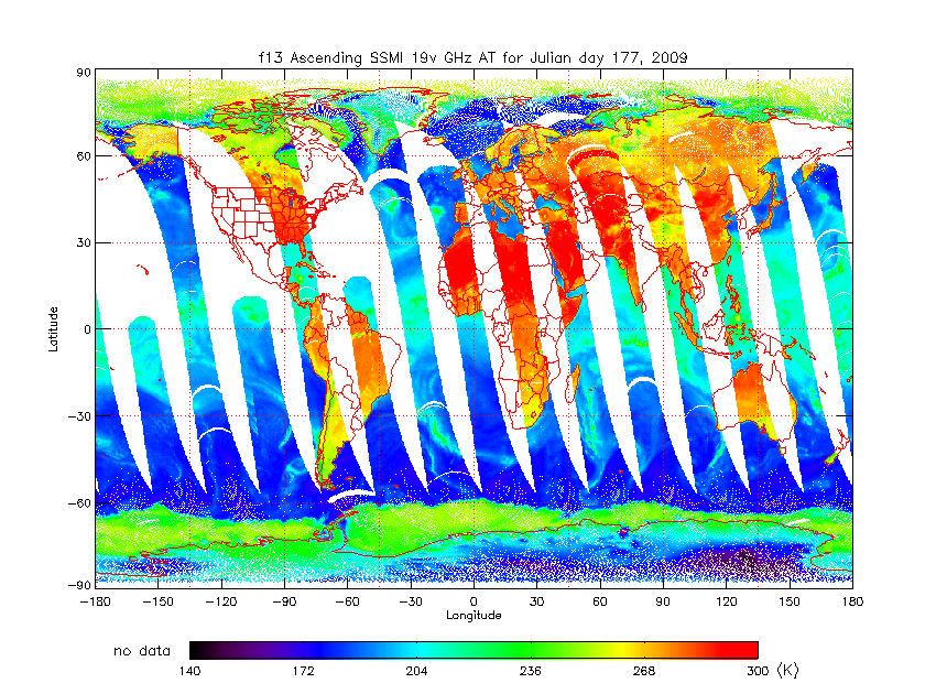 SSM/I Ascending 19 Vertical GHz Antenna Temperature
This Version 7 NOAA Fundamental Climate Data Record (CDR) from Remote Sensing Systems (RSS) contains brightness temperatures that have been inter-calibrated and homogenized over the observation time period. The temperature data are from the Special Sensor Microwave Imager (SSM/I) and Special Sensor Microwave Imager Sounder (SSMIS) series of passive microwave radiometers carried onboard the Defense Meteorological Satellite Program (DMSP) satellites. These satellite sensors measure the natural microwave emission coming from the Earth’s surface in the spectral band from 19 to 85 GHz. This dataset encompasses data from a total of seven satellites including the SSM/I sensors on board DMSP satellites F08, F10, F11, F13, F14, and F15 as well as the SSMIS sensors on board DMSP satellite F17. The data record covers the time period from July 1987 through the present with a one month latency. The spatial and temporal resolutions of the CDR files correspond to the original resolution of the source SSMI(S) observations. There are roughly 15 orbits per day with a swath width of approximately 1400 km resulting in nearly global daily coverage. The spatial resolution of the data is a function of the sensor/channel and varies from approximately 50 km for the lowest frequency channels to approximately 15km for the high-frequency channels. The output parameters include the observed brightness temperatures for each of the seven SSM/I channels and 24 SSMIS channels at the original sensor channel resolution along with latitude and longitude information, time, quality flags, and view angle information. The file format is netCDF-4 with added metadata that follow the Climate and Forecast (CF) Conventions and Attribute Convention for Dataset Discovery (ACDD). There are three major changes in the Version 7 processing: (1) the water vapor continuum absorption model was re-derived, (2) the clear-sky bias in cloud water was removed and the data format for cloud water was changed, and (3) the beamfilling correction in the rain algorithm was modified. Relative to Version 6, Version 7 has: (1) increased vapor values in the range of 50-60 mm by 1%, (2) increased vapor values above 60 mm by 2-3%, (3) cloud data changed to the range of cloud water values: -0.05 to 2.45 mm (cloud data format has changed), and (4) increased the global mean rain rates by about 16% (mostly due to changes in the extratropical values).
- Cite as: Frank J. Wentz, Carl A. Mears, and NOAA CDR Program (2013): NOAA Climate Data Record (CDR) of SSM/I and SSMIS Microwave Brightness Temperatures, RSS Version 7. [indicate subset used]. NOAA National Centers for Environmental Information. doi:10.7289/V5SJ1HKZ [access date].
- doi:10.7289/V5SJ1HKZ
- NCEI DSI 3623_04
- gov.noaa.ncdc:C00810
C00810
| Download Data |
|
| Order Data |
|
| Distribution Formats |
|
| Ordering Instructions | Contact NCEI for other distribution options and instructions. |
| Distributor | NOAA National Centers for Environmental Information
ncei.info@noaa.gov |
| Dataset Point of Contact | NOAA Climate Data Record Program Office
DOC/NOAA/NESDIS/NCEI > National Centers for Environmental Information, NESDIS, NOAA, U.S. Department of Commerce +1 (828) 271-4800 rss_ssmi_contacts@noaa.gov |
| Time Period | 1987-07-09 to Present |
| Spatial Bounding Box Coordinates |
N: 90.0
S: -90.0
E: 180.0
W: -180.0
|
| Spatial Coverage Map | |
| General Documentation |
|
| Processing Documents |
|
| Associated Resources |
|
| Publication Dates |
|
| Edition | Version 7.0 |
| Data Presentation Form | Digital image
|
| Dataset Progress Status | Ongoing - data is continually being updated |
| Data Update Frequency | Monthly |
| Purpose | For the Remote Sensing Systems (RSS) Version-7 Special Sensor Microwave Imagers (SSM/I) FCDR, the six SSM/Is (aboard F08, F10, F11, F13, F14, and F15) have been carefully inter-calibrated which allow investigators to confidently use these SSM/I products for detailed inter-annual and decadal trend studies. |
| Use Limitations |
|
| Dataset Citation |
|
| Cited Authors |
|
| Principal Investigators |
|
| Collaborators |
|
| Publishers |
|
| Theme keywords | Global Change Master Directory (GCMD) Science Keywords
|
| Data Center keywords | Global Change Master Directory (GCMD) Data Center Keywords
|
| Platform keywords | Global Change Master Directory (GCMD) Platform Keywords
|
| Instrument keywords | Global Change Master Directory (GCMD) Instrument Keywords
|
| Place keywords | Global Change Master Directory (GCMD) Location Keywords
|
| Project keywords | Global Change Master Directory (GCMD) Project Keywords
|
| Use Constraints |
|
| Access Constraints |
|
| Fees |
|
| Processing Steps |
|
Last Modified: 2023-08-10
For questions about the information on this page, please email: ncei.info@noaa.gov