Article

Ecological Health Risk Assessment and Source Identification of Heavy Metals in Surface Soil Based on a High Geochemical Background: A Case Study in Southwest China

1
School of Earth Sciences, Chengdu University of Technology, Chengdu 610059, China
2
Applied Nuclear Technology in Geosciences Key Laboratory of Sichuan Province, Chengdu University of Technology, Chengdu 610059, China
3
Department of Geophysical and Geochemical Exploration, Yunnan Institute of Geological Survey, Kunming 650216, China
4
Wuhan Center, China Geological Survey (Central South China Innovation Center for Geosciences), Wuhan 430205, China
5
Institute of Geophysical & Geochemical Exploration, Chinese Academy of Geological Sciences, Langfang 065000, China
*
Authors to whom correspondence should be addressed.
Toxics 2022, 10(6), 282; https://doi.org/10.3390/toxics10060282
Submission received: 1 May 2022 / Revised: 22 May 2022 / Accepted: 23 May 2022 / Published: 25 May 2022
(This article belongs to the Section Exposome Analysis and Risk Assessment)

Abstract

:
A total of 28,095 surface soil samples were collected in areas with high natural background levels; the potential ecological risk is generally low, and the high-risk area is small and mainly affected by lead–zinc mines. The contribution to the potential ecological risk factor (RI) is as follows: Hg > Cd > As > Pb > Cu > Ni > Cr > Zn, with noncarcinogenic chronic risks of Cr > As > Cd > Pb > Ni > Cu > Hg > Zn; furthermore, dermal contact is the main pathway of exposure causing health risks. The total carcinogenic risks caused by heavy metals were as follows: Cr > Cd > As > Pb; and the risks posed by Cr, Cd, and As were higher than the threshold value (1.0 × 10⁻⁴); people face a higher threat to heavy metals in soils in Zhenxiong, Ludian, Huize, Weixin, and Zhaoyang. The evaluation result of the EPA PMF model shows that the soil heavy metals are mainly composed of five sources, of which basalt, Permian, and Triassic carbonate rock parent material constitute the natural background source, while the mining activities of lead–zinc mines and the emissions of coal burning by residents constitute the anthropogenic source. The contribution was ranked in order of lead–zinc mining (26.7%) > Triassic carbonate (23.7%) > basalt (20.9%) > coal burning and automobile emissions (16.1%) > Permian carbonate (12.6%).

Graphical Abstract

1. Introduction

Ecological risk assessment is an important part of environmental risk assessment, and it is the process of assessing the possibility of negative ecological effects occurring because of exposure to single or multiple pollution factors [1]. Health risk assessment, including noncarcinogenic and carcinogenic risk assessment, has been recognized as an important tool for identifying health risks in human activities [2]. To date, several studies have been carried out on the ecological risk assessment of heavy metals in contaminated soil [3,4,5]. In recent years, the ecological-health risk assessment of heavy metals in soil has mainly focused on the safety of polluted mining areas, enterprises, and agricultural soil or crops [6,7,8,9,10,11,12,13]. These areas have obvious human activities, and the research results are based on the evaluation of the total amount of heavy metals and the complete exposure pathways. However, there are few studies on heavy metals in soil from nonagricultural or nonindustrial areas; these sites are considered to be a source of natural metals, and the influences of soil from different land-use types are rarely emphasized in the process of risk assessment.
Northeast Yunnan is a typical area with high geochemical levels of heavy metals in southwestern China. Compared with the background value of soil (layer A) in China [14,15], there are eight heavy metals of interest, including arsenic (As), cadmium (Cd), chromium (Cr), copper (Cu), mercury (Hg), nickel (Ni), lead (Pb), and zinc (Zn); these eight heavy metals show enrichment, except for As, Cu, and Cd, which are strongly enriched, and their enrichment coefficients are 3.2 and 5.8, respectively. Northeast Yunnan is a region with a high geochemical background of heavy metals in soil. Cheng et al. [16] believe that the parent material in the area is the decisive factor affecting the composition of elements in the soil. Some studies suggest that the natural source of heavy metals in the soil is caused by the weathering parent mafic rocks, black shale, and limestone [17,18,19,20]. The clay minerals and Fe–Mn oxides in basalt weathering products are the main reasons for the enrichment of Ni, Cr, and other heavy metals in surface soil [20,21,22]. Wang et al. [20] traced the source and migration process of heavy metals through the basalt-surface soil-crop system using Ni in the basalt weathered soil of eastern China for the first time. Wu et al. [23] carried out a large-scale ecological risk assessment on agricultural soil by using a regional evaluation model and tried to discuss the relationship between the assessment results of the whole region and the parent material of the soil, and the results showed that the large-scale evaluation depended largely on the analysis of the parent material. Wen et al. [19] believed that the heavy metals in soil with a high geochemical background came from the weathered accumulation of the parent rock based on the isotope analysis of the soil profile; however, they have not completed the classification of natural heavy metal sources. Northeastern Yunnan is a typical middle-alpine cutting landform, with scattered and diverse land-use types, and the range of high geochemical background levels of heavy metals in the soil is large. Relevant research shows that there is a close relationship between ecological risk and land-use type [24,25,26,27,28]; thus, risk assessments that do not consider land-use type may overestimate or underestimate the risk level of heavy metals in the soil, resulting in excessive treatment costs.
Basalt and carbonate rocks are widely distributed in the area with high geochemical background levels in northeastern Yunnan, and those rocks have become the main soil-forming parent materials. The special geographic location and topography determine the diversity of land-use types in the study area. Therefore, these factors cannot be ignored when conducting soil ecological geochemical assessments in the study area; specifically, it is believed that the heavy metal sources of soil are caused by different land-use types and different parent materials. The results of the comprehensive classification of soil environmental quality show that the first-class environmental quality of soil in northeast Yunnan spans an area of 1456 km2, accounting for 5.2% of the survey area, and the second-class quality spans 86.5% of the survey area, which shows that the heavy metals in the soil in the area pose a high potential risk. It is of great significance to carry out surveys of heavy metals in soil and ecological health risk assessments in northeast Yunnan.
This article refers to a relatively mature risk assessment model in the “Ecological Risk Assessment Guide” from the US Environmental Protection Agency (USEPA), combined with the land-use types of the study area. The research focuses on eight heavy metals, including As, Cd, Cr, Cu, Hg, Ni, Pb, and Zn, and the risk of chronic intake and carcinogenicity of soil in the high geochemical background area of heavy metals of northeast Yunnan were evaluated under three exposure methods: dietary intake, unintentional inhalation, and dermal contact. At the same time, the positive matrix factorization model (PMF) proposed by the USEPA [29] was used to identify the source of heavy metal pollutants in the high geochemical background area in a large spatial range. The regional ecological risk assessment provides examples and assistance for the management of heavy metals from natural sources and the selection of research methods in typical areas with high geochemical background levels of soil heavy metals in southwest China.

2. Materials and Methods
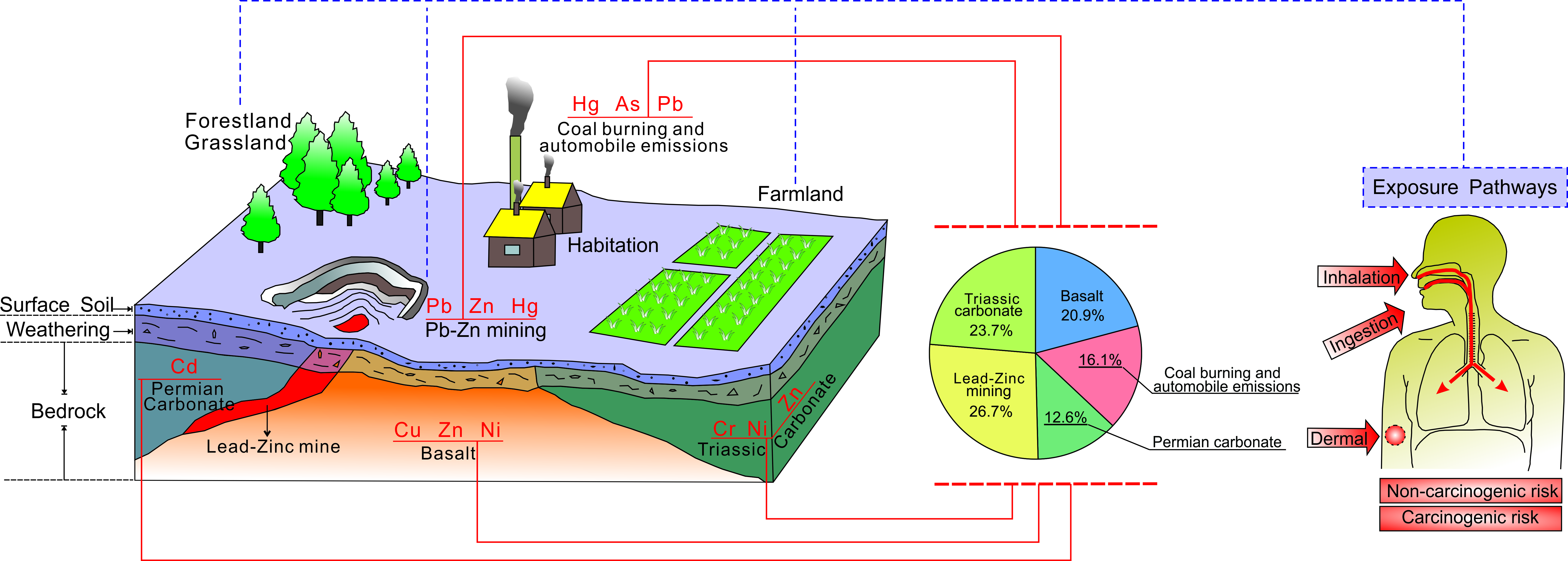
2.1. Research Area

The study area is located in northeastern Yunnan Province, southwestern China. The geographical coordinates are 102°50′–105°20′ E, 25°46′–28°46′ N, covering approximately 28,066 km2. The administrative division is under the jurisdiction of Zhaotong and Qujing (Figure 1). The study area has a plateau monsoon three-dimensional climate with both plateau subtropics and warm temperate zones, with an average annual temperature of 12.6 °C. The highest altitude in the area is 4025 m, and the lowest altitude is 175 m, which belongs to the deep-cut alpine landform, and most of the area is composed of carbonate karst. Various types of land resources are scattered in the area because of the influence of topography and landform diversity, and the land-use types are diverse and complex. The predominant land-use types in the study area are forestland and grassland, accounting for 58.6% of the total land area, while agricultural land accounts for only 35.5% [30]. The area is mainly based on agricultural planting, and the special landform provides unique conditions for agricultural production in the area; at the same time, the unique landform necessitates higher requirements for adapting agricultural production to local conditions. The research area is located in the middle and upper reaches of the Yangtze River and is located in the watershed area of the Jinsha River, the Niulan River, and the Luoze River, with other water systems running through it. It is an important soil and water conservation area. In recent years, the ecological environment in the region has deteriorated; for example, serious soil erosion, sharp reductions in forest resources, and soil pollution caused by deposit mining occur frequently, and it is necessary to evaluate the ecological environmental risk posed by soil in the area.

2.2. Sample Collection

The study was completed on the basis of the national multipurpose soil survey. Surface soil samples were collected at a density of one sample/km2 from a sampling depth of 0–20 cm, and a total of 28,095 surface soil samples were collected. The collected soil samples were sun-dried, ground, and sieved through a +20 mesh sieve, and the sample combination was carried out using a 2 km × 2 km grid. A total of 7309 combined samples were obtained in this study. After the combined samples were mixed, approximately 30 g of sample was removed and used for pH analysis. Approximately 80 g of sample was taken and dried in an oven at 60 °C. Then, a pollution-free planetary ball mill was used to crush the sample to −200 mesh particle size to create an analytical sample that was sent to the laboratory for analysis. This evaluation work was carried out based on the analysis data of the 7309 surface soil samples that were obtained.

2.3. Analytical Methods and Quality Control

Soil samples were decomposed with hydrofluoric acid, nitric acid, and perchloric acid. After decomposition with aqua regia, the samples were moved to a plastic test tube, and then the volume was set and shaken. The clear solution was separated, and 3% nitric acid solution was used to dilute the solution 1000 times. Then, inductively coupled plasma-mass spectrometry (ICP-MS) was used to test the Cd, Cu, Ni, Pb, and Zn, and full-spectrum direct reading inductively coupled plasma-emission spectroscopy (ICP-OES) was used to complete the Cr test. Samples were decomposed with aqua regia, potassium permanganate solution was added for oxidation treatment, and the solution was diluted with oxalic acid solution. Then, potassium borohydride was used as a reducing agent to be pre-reduced by thiourea-ascorbic acid. Atomic fluorescence spectrometry (AFS) was used to measure the As with HG-AFS. Finally, the remaining solution was directly diluted to measure the Hg with CV-AFS using SnCl2 as a reducing agent.
Quality assurance and control measures were used throughout the testing process, and the national first-level standard substances (GBW07401–GBW07408, GBW07425–GBW07428) were used as the standard reference materials to monitor the testing process. During the analysis, four pieces of password samples were inserted for each batch (approximately 50 samples) for external and internal quality controls. Two blank tests were carried out in an analysis batch to control the blank changes. The results showed that the overall pass rate of the first-level standard substance samples for monitoring accuracy was 100%, the overall pass rate for the precision monitoring samples was 100%, the total element reporting rate was 99.97%, and the overall pass rate of randomly selected 5% repeatability test samples was 99.5%. The analysis results met the quality requirements of the technical specification for multipurpose regional geochemical survey DZ/T0258-2014 [31].

2.4. Assessment Methods of Heavy Metal Pollution in Soils

2.4.1. Ecological Risk Index

In this study, the potential ecological risk index (PERI) was used to evaluate the potential ecological risk of heavy metals in soil. The PERI of a single heavy metal ( E r i ) and compound with eight heavy metals (RI) were calculated by Equations (1)–(3) [32]:
C f i = C s i C n i
E r i = T r i × C f i
R I = 1 m E r i
where C f i is the pollution index of heavy metal i; C s i is the test value of heavy metal i in the soil sample; C n i is the background value of heavy metal i; T r i is the biological toxicity response factor of each heavy metal; and the values of T r i are listed in Table 1.
The PERIs of eight heavy metals, including As, Cd, Cr, Cu, Hg, Ni, Pb, and Zn, in soil were calculated. Hakanson [32] divided the ecological risk compound index (RI) into four risk levels: extremely strong risk (600 ≤ RI), strong ecological risk (300 ≤ RI < 600), moderate ecological risk (150 ≤ RI < 300), and low ecological risk (RI < 150), which helps researchers analyze the risk more intuitively.

2.4.2. Noncarcinogenic Risk Assessment

The health risk assessment models provided by the USEPA were used in this study to evaluate noncarcinogenic risk [34,35,36]. This model considers different exposure pathways and the effects of different exposure frequencies based on different land uses. Adults in the living environment are mainly affected by the following three soil exposure pathways: (1) human beings ingest heavy metals through their daily diet; (2) inadvertent inhalation of heavy metals from surface dust and atmospheric dust; and (3) dermal absorption caused by contact with soil through production activities. The chronic daily intake of heavy metals under the three exposure pathways can be calculated as Equations (4)–(6) [7,36,37,38,39,40]:
C D I i n g e s t = C s o i l × I R i n g × E D × E F B W × A T × C F
C D I i n h a l e = C s o i l × I R i n h × E D × E F P E F × B W × A T
C D I d e r m a l = C s o i l × S A × S L × A B S × E D × E F B W × A T × C F
where C D I i n g e s t , C D I i n h a l e , and C D I d e r m a l represent the chronic intake of heavy metals under three exposure pathways of ingestion, inhalation, and dermal contact, respectively, mg·(kg·d)−1; C s o i l is the concentration of heavy metals in the single pollution of surface soil, mg·kg−1; I R i n g and I R i n h are the weights of ingestion and inhalation soil intake, respectively, mg; all the parameters used in this study are shown in Table 2. The exposure frequency (EF) selects different EFs according to different land-use types in the study area: the farmland and residential land EF is 350 day·a−1; the industrial and mining land EF is 250 day·a−1; the forestland, grassland and other land-use type EF values are equal to 40 day·a−1 [36,38]. Exposure duration (ED) is divided into noncarcinogenic chronic risk and carcinogenic risk. The exposure period of noncarcinogenic chronic risk is 24 years [36], and the exposure period of carcinogenic risk is a lifetime. This study uses the average life expectancy of Yunnan Province in China calculated by the National Bureau of Statistics of China in 2019 of 69.5 years [41].
Heavy metals in the soil can be ingested by the human body through multiple exposure pathways, causing the risk of chronic diseases. It is defined as the hazard quotient (HQ) and characterized by the ratio of the amount of heavy metals ingested by the human body to the specified reference dose (RfD) of the pollutant under different exposure pathways. The hazard index (HI) is the sum of chronic risks. In this study, the HI represents the health risks of chronic diseases in humans caused by the three exposure pathways of the eight heavy metals, including As, Cd, Cr, Cu, Hg, Ni, Pb, and Zn. Chronic diseases may occur when the HI is greater than 1, and the risk of diseases increases with an increasing HI [36]. The HQ and HI of heavy metals can be expressed with Equations (7) and (8):
H Q i j = C D I i j R f D i j
H I = j = 1 n i = 1 n H Q i j
where C D I i j represents the chronic daily intake of ith heavy metal through the jth exposure pathway, mg·(kg·d)−1; R f D i j represents the reference dose of ith heavy metal under the jth exposure pathway, mg·(kg·d)−1; and the reference dose corresponding to a single heavy metal used in this study is listed in Table 3.

2.4.3. Carcinogenic Risk Assessment

Soil carcinogenic risk is characterized by the probability that an individual will experience cancer through lifelong exposure to carcinogens in the environment, and this value is obtained by establishing a cancer slope factor (CSF) through the individual exposure to soil carcinogens by various exposure pathways [35], and the carcinogenic risk is calculated by Equation (9):
R i s k c a r j = C D I j × C S F j
where R i s k c a r j is the carcinogenic risk from the jth exposure pathway, C D I j is the chronic daily intake of a carcinogen under the jth exposure pathway, mg·(kg·day)−1; and C S F j is the carcinogenic slope factor of the carcinogen under the jth exposure pathway. The carcinogenic slope factors used in this study are shown in Table 3, in which the skin absorption carcinogenic slope factors of Cd and Pb are calculated by dietary intake carcinogenic slope factors [36,50,51]. The calculation is shown in Equation (10). Finally, the comprehensive carcinogenic risk of a carcinogen was obtained by calculating the carcinogenic risk coefficient under different exposure pathways (Equation (11)) [40,52].
C S F d e r m a l = C S F i n g e s t A B S G I
R i s k c a r = R i s k i n g e s t + R i s k i n h a l e + R i s k d e r m a l
where A B S G I is the gastrointestinal absorption factor, and the gastrointestinal absorption coefficients of Cd and Pb used in this study are 0.025 and 1.0, respectively [44]. Commonly, when the cancer risk coefficient ( R i s k c a r ) is lower than 1.0 × 10⁻⁶, which is equivalent to the probability of cancer occurring in one out of 1,000,000 people, the risk can be considered to be negligible, and when it is higher than 1.0 × 10⁻⁴, it is recognized that the carcinogenic risk is unacceptable [35,53]. Therefore, 1.0 × 10⁻⁶ has been recognized as the threshold for determining carcinogenic risk [54,55].

2.5. Positive Matrix Factorization Model (PMF)

The PMF is a reliable and effective pollution source identification method proposed by the USEPA [29]. It is used to calculate the source profile and source contributions of acceptor chemical components, and it can be expressed as follows:
X i j = k = 1 P g i k f k j + e i j
where X i j represents the concentration of jth element in the ith sample, mg·kg−1; g i k is the contribution of the ith sample from the kth source; f k j is the component of element j in source k; e i j is the residual matrix; and P is the number of factors. In addition, the objective function Q by the PMF model can be expressed as follows:
Q i = j = 1 n i = 1 m e i j u i j 2
where u i j is the uncertainty of the jth element in the ith sample, which is calculated by the concentration and method detection limit (MDL). The concentration of each heavy metal in this study is greater than the MDL; therefore, the uncertainty can be expressed as follows:
u i j = δ × C 2 + 0.5 × M D L 2
where δ is the relative deviation, generally 5% [8,29,56,57]; C is the concentration of element j, mg·kg−1; and MDL is the method detection limit.

2.6. Statistical Analysis

Statistical analysis of characteristic parameters was performed by SPSS (version 19.0) (IBM, Almonk, NY, USA) software. The spatial distributions of heavy metal concentrations adopted the power exponential weighting method using the software GeoIPAS (version 3.2) (Jinwei Graphic Information Technology Co., Ltd., Urumqi, China), and the ecological health risks were determined using the software ArcGIS (version 10.2) (Esri, Redlands, CA, USA). The identification of heavy metal sources was performed using PMF (version 5.0) (USEPA, Washington, DC, USA).

3. Results and Discussion

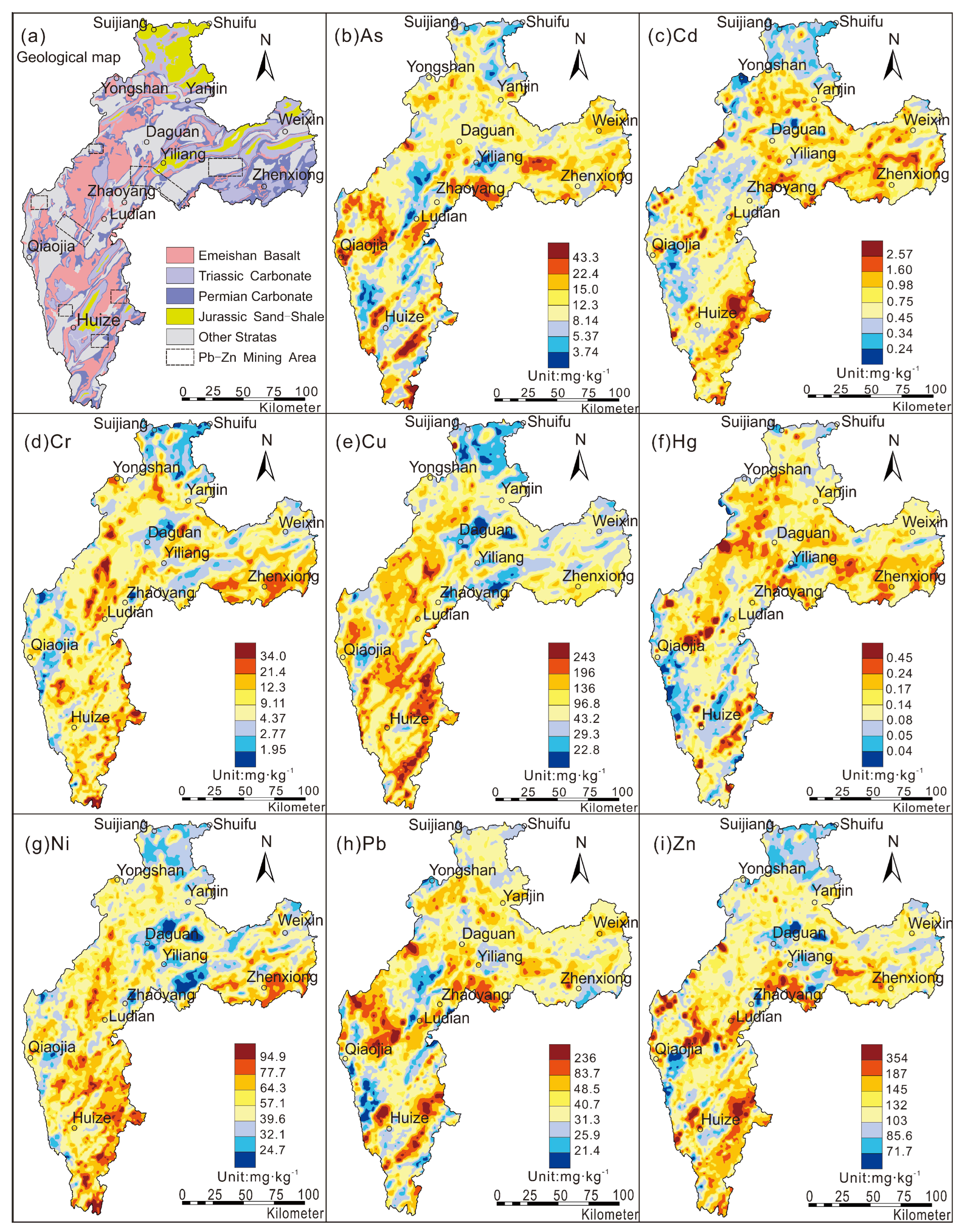
3.1. Soil Properties and Metal Accumulation in Soils

According to the statistical results of soil heavy metals in the study area (Table 4), these eight heavy metals showed enrichment, except for As, relative to the background value of soil (layer A) in China [14,15]. The background values of heavy metals Cu and Cd are 73.6 mg·kg−1 and 0.56 mg·kg−1, respectively, and their enrichment coefficients are 3.2 and 5.8, respectively, which are values indicative to the typical soil heavy metal enrichment area in southwest China. The coefficients of variation of Cu, Hg, Cd, and As in the area are 72%, 53%, 50%, and 48%, respectively, with a wide variation range, which shows that the sources of these heavy metals are complex. Based on the ratio of geochemical background value to reference value (Kbackground/reference) in the study area, it is clear that As, Cd, Hg, and Pb are strongly enriched in the surface soil relative to the deep soil, and more than 80% of the surface soil in the study area displays enriched Cd; compared to the deep soil, the surface soil enrichment degree is 3.5 times greater. These characteristics indicate that most of the heavy metals in the surface soil are affected by natural or human activities during the process of soil formation. As a result, the distribution pattern of heavy metals in the surface soil changes, especially the biophilic elements and environmental elements, which are the most significantly affected. These elements show the characteristics of regional enrichment, while others show local enrichment or depletion affected by fractional factors (Figure 2). The heavy metal characteristics in the soil of areas with high geochemical background levels are related to the inheritance of the parent material and driven by the element geochemical driving mechanism and the distribution of typical parent material of carbonate rock [16,19,58,59]. However, the widely distributed lead–zinc deposits (spots) in the area have become another main source of heavy metals in the soil, and the spatial distribution of As, Pb, and Cd shows enrichment characteristics in the mining area (Figure 2). Therefore, it is believed that the heavy metals in the surface soil of the study area have multiple sources, and mining is one of them.
Table 4. Descriptive statistics for heavy metal concentrations in surface soil.
ItemsAsCdCrCuHgNiPbZn
wt/mg·kg−1
Arithmetic Mean110.6412295.40.135337122
Std.deviation5.260.3247.068.90.0719.110.832.2
Coefficient of variation (%)4850397253362926
Maximum26.71.602623020.3211069.2218
Minimum1.440.0415.43.160.024.108.8927.3
Geometric Mean10.30.6411972.30.1150.237.4120
Background value10.10.5610973.60.1152.535.1122
Background value of Chinese soil [14,15]11.20.1061.023.00.0727.026.074.0
Enrichment coefficient (Dimensionless)0.905.771.793.201.721.941.351.65
Figure 2. Spatial distribution of heavy metal concentrations in the study area. (a) geological map, (b) As, (c) Cd, (d) Cr, (e) Cu, (f) Hg, (g) Ni, (h) Pb, (i) Zn.
Toxics 10 00282 g002

3.2. Heavy Metal Pollution Assessment in Soils

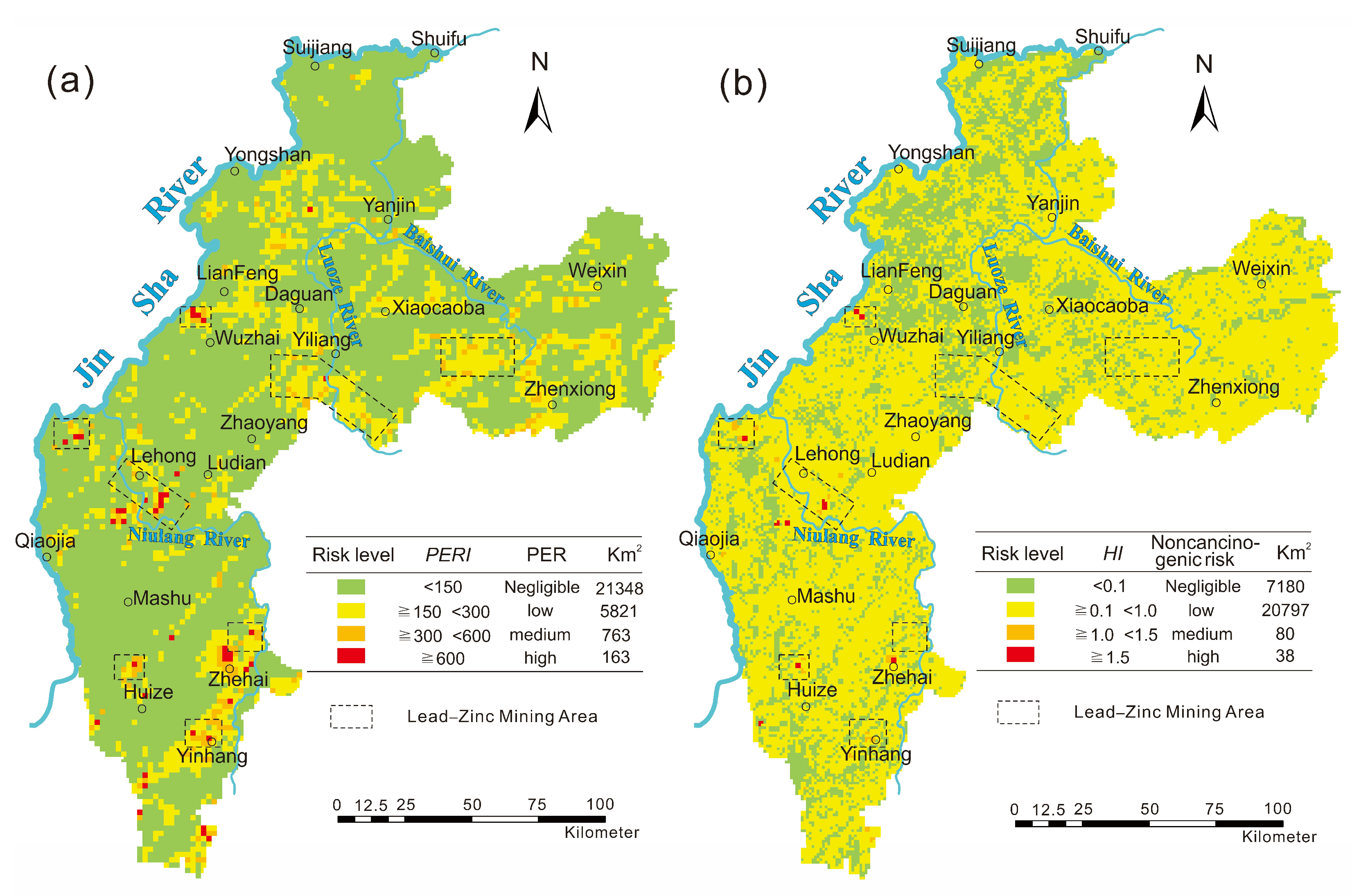
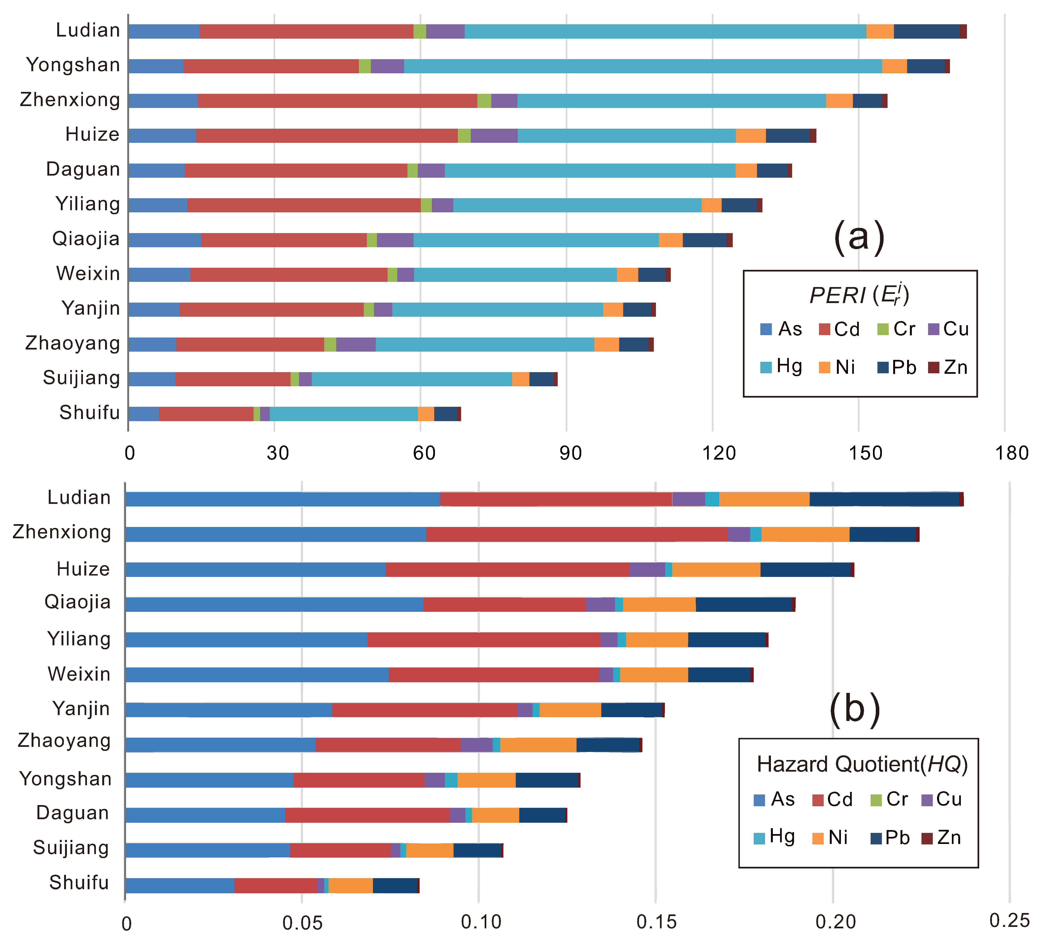
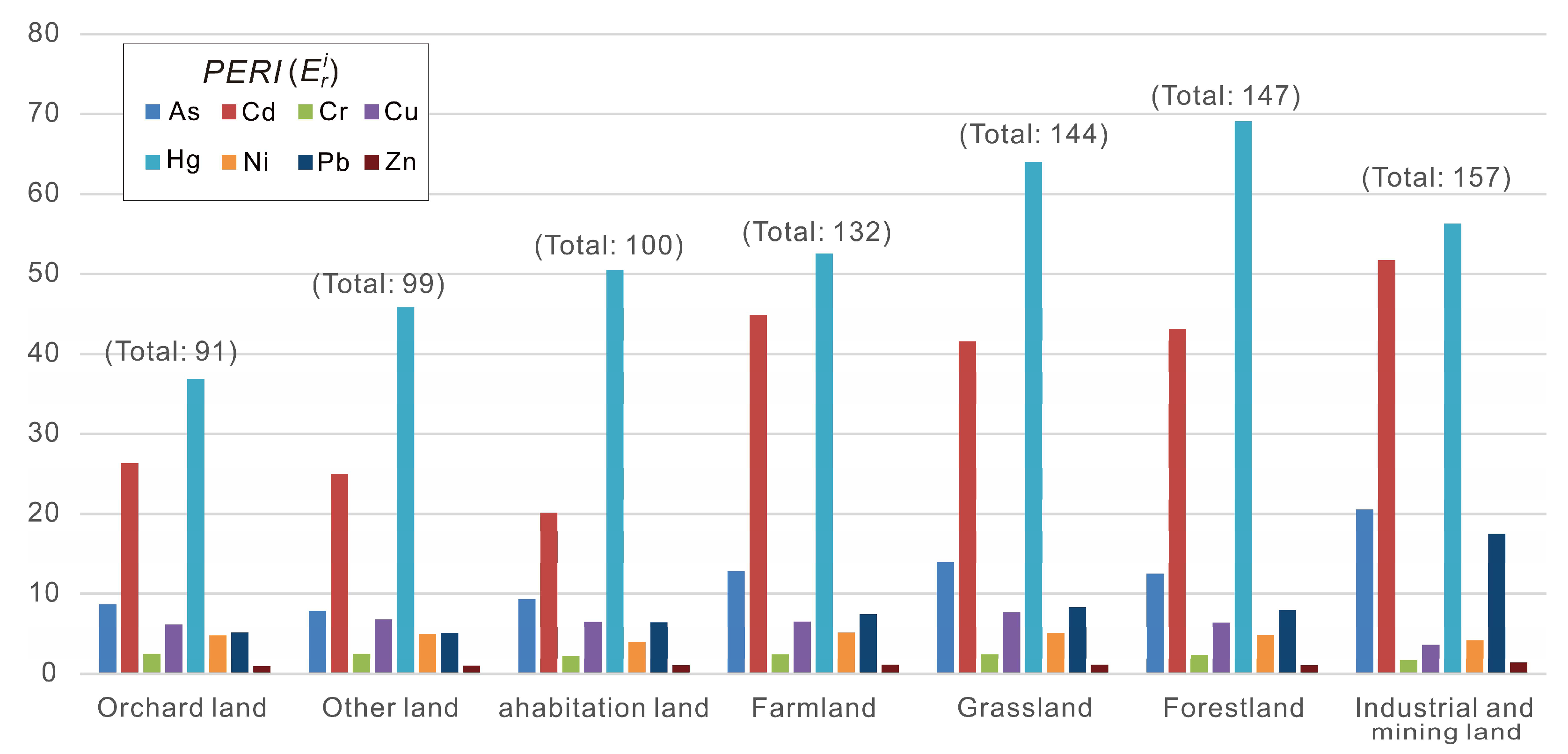
3.2.1. Potential Ecological Risk of Heavy Metals in Soil

The PERIs of heavy metals in 28,095 sampling sites of surface soil were calculated and are shown in Figure 3a, which shows that 76% of the study area has a low ecological risk (RI < 150); moderate ecological risk areas (150 ≤ RI < 300) account for 20.7% of the study area and are mainly distributed in Huize, Ludian, Yongshan, Yiliang, and Zhenxiong; high ecological risk areas (300 ≤ RI < 600) account for 2.72% of the study area and are interspersed with moderate-risk areas; extremely high ecological risk areas (600 ≤ RI) account for less than 1% of the study area and can be found in Huize, Ludian, and Yongshan. It is worth noting that the distribution of extremely high ecological risk areas is consistent with lead–zinc mining in the study area (Figure 3a). It is believed that the extremely high potential ecological risks of heavy metals in the soil are mainly caused by mining activities.
The distribution of the single indicator PERI ( E r i ) in each county shows that the largest contribution to the compound ecological risk (RI) is Hg ( E r H g ), followed by Cd ( E r C d ) and As ( E r A s ) (Figure 4a). Hg, Cd, and As are the main elements that cause potential ecological risks in soil. The contribution rates of the eight heavy metals to ecological risks followed a descending order: Hg > Cd > As > Pb > Cu > Ni > Cr > Zn (Figure 4a). Ludian and Yongshan have the highest risk of Hg pollution, while the risk of Cd mainly affects Zhenxiong and Huize County, and the risk of As is concentrated in Qiaojia, Ludian, and Zhenxiong. The average value of the compound ecological risk indexes (RI) in Ludian, Yongshan, and Zhenxiong is higher than 150, which shows a high potential ecological risk of heavy metals in these three counties. The RI values of the other counties are all greater than 100 except for that in Suijiang and Shuifu (Figure 4a), indicating that the total amount of heavy metals in the soil is relatively high and that there is serious potential ecological risk in the study area.
The potential ecological risk of heavy metals in the soil of the study area has obvious differences between various land-use types (Figure 5). Figure 5 shows that the soil of industrial and mining land has the highest ecological risk, and the total ecological risk indexes of the eight heavy metals exceed 150, followed by that of forestland and grassland. Hg, Cd, and As are still the major elements causing risk. Among these heavy metals, Hg shows a high risk in all land-use types, especially forestland and grassland ( E r H g   > 60); the risk of Cd is relatively high in the soil of industrial land, mining land, and farmland, followed by forestland and grassland. The soil in these three land-use types has frequent human activities, and soil from forestland and grassland is generally characterized by the accumulation of organic matter. Both of these characteristics explain the accumulation of heavy metals in soil [19], and it has been shown that the Cd ecological risk is affected not only by human activities but also by the adsorption of organic matter in the surface soil. The ecological risk of heavy metal As is more significant in the soil of industrial and mining land, indicating that its source is mainly related to the lead–zinc mine in the area. Heavy metals show different levels of potential ecological risks in different land-use types, and the source of heavy metals in the area is complex and more or less restricted by types of land use. More importantly, the impact of land-use types on ecological risk assessment in the area cannot be ignored.

3.2.2. Noncarcinogenic Risk Assessment

The exposure of heavy metals in soil can be characterized by the chronic daily intake (CDI), mg·(kg·day)−1. The results of several studies on the accumulation of heavy metals in soils under different land uses show that the diversity of land-use patterns directly affects the exposure frequency and CDI of adults exposed to the soil environment, which leads to unreasonable evaluation results of human health risks under different exposure methods [25,26]. The land-use types in the study area are mainly forestland, farmland, and grassland, and there are a small number of paddy fields, orchard land, urban land, and industrial and mining land scattered throughout the area. This study selected different exposure pathways according to the production and living conditions of adults under different land-use types. Agricultural land and residential land EF is 350 day·a−1; industrial and mining land EF is 250 day·a−1; and forestland, grassland, and other land-use type EF values are equal to 40 day·a−1 [36,38]. The CDIs of eight heavy metals were calculated through dietary intake, inadvertent inhalation, and dermal contact, and the calculation results of the hazard quotient (HQij) and the hazard index (HI) of 28,095 samples were based on the known reference dose (RfD), mg·(kg·day)−1 [44,46,47].
As seen from Figure 3b, the noncarcinogenic chronic risk of soil in the study area is generally shown as low risk (0.1 ≤ HI < 1.0), accounting for 74% of the study area; moderate-risk areas (1.0 ≤ HI < 1.5) are distributed in Huize, Ludian, and Yiliang, accounting for 0.28% of the study area. Huize and Ludian are the main areas with moderate risk, which may be related to the widespread existence of Cd-rich strata causing the accumulation of the heavy metal Cd in the soil. High-risk areas (1.5 ≤ HI) are scattered in Huize, Ludian, and Daguan counties, of which the Ludian–Lehong and Zhehai areas are more concentrated (Figure 3b); these counties are areas with concentrated lead–zinc mines, indicating that the mining process is one of the important causes of health risks posed by the soil.
As has the largest contribution to human noncarcinogenic chronic risk, with an average contribution of more than 35%, followed by that of Cd and Pb. The contribution rates of the eight heavy metals to the HQ followed a descending order: HQAs > HQCd > HQPb > HQNi > HQCu > HQHg > HQZn > HQCr (Figure 4b). The contribution order of heavy metals to the HI under the three exposure pathways was HQdermal > HQingest > HQinhale, where the average value of HQdermal exceeded 55%, which was the main exposure pathway in which adults were exposed to heavy metals in the study area. Among the 12 counties in the study area, the average human health risk index values in Ludian, Zhengxiong, and Huize were all greater than 0.2, indicating a higher risk; the values in Shuifu were relatively low (HI < 0.1), and the remaining counties had values between 0.1 and 0.2 (Figure 4b).

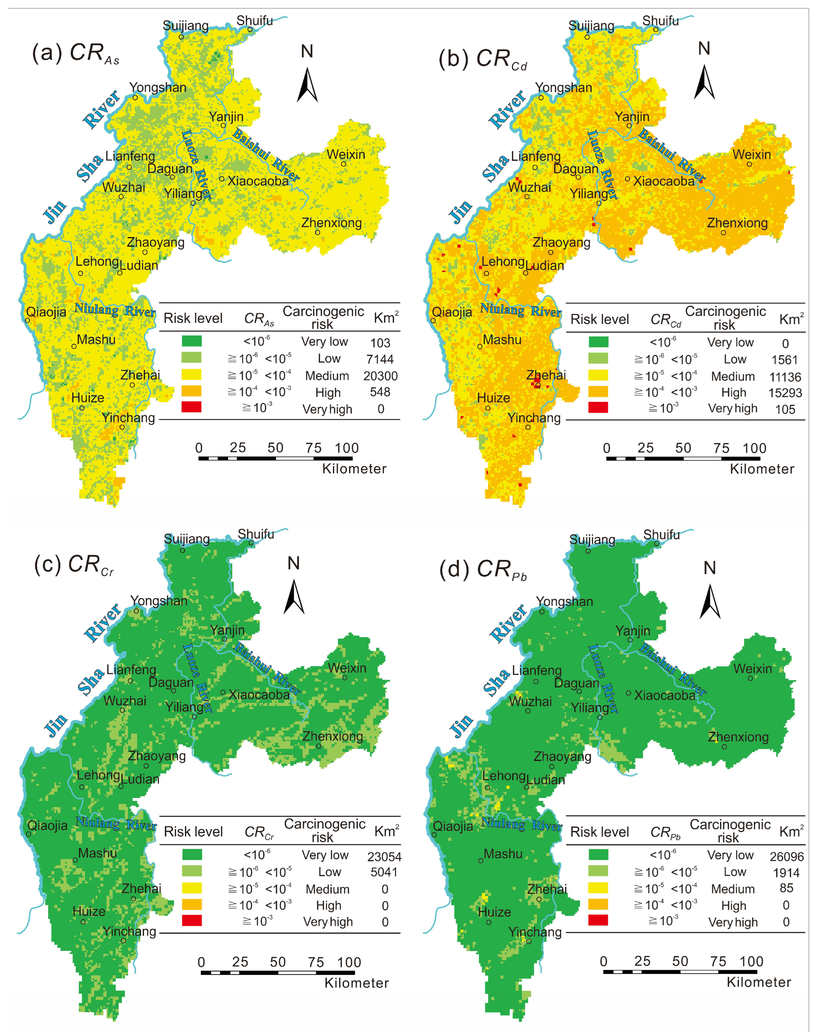
3.2.3. Carcinogenic Risk Assessment

This study conducted a carcinogenic risk assessment of the heavy metals As, Cd, Cr, and Pb in the surface soil. The remaining heavy metals were not evaluated in this study since there is no cancer risk factor reported. The carcinogenic risk of As was moderate, accounting for 72.3% of the research area. The high-risk areas were mainly concentrated in Huize, Yinchang, Wuxing, Lehong, Yiliang, Maoping, and Wanchang, accounting for 2% of the research area (Figure 6a). The high carcinogenic risk of As was consistent with the distribution of lead–zinc mines in the study area, indicating the risk was mainly caused by lead–zinc mining activities. The carcinogenic risk of Cd was mainly high risk, accounting for 54.4% of the research area. The high-risk areas were mainly distributed in Zhenxiong, Weixin, Huize, and Ludian, and the extremely high-risk areas were distributed in Yinchang, Lehong, and Yi Liang (Figure 6b), which was the result of the simultaneous actions of Permian carbonate and lead–zinc mining activities [16]. The carcinogenic risk index of Cr and Pb was less than 1.0 × 10⁻⁴, and the whole area showed negligible risk (Figure 6c,d). Cr and Pb was enriched in the soil of the study area, but duo to the lack of a reported CSF of Cr and the CSF of Pb was 1–2 orders of magnitude lower than the other elements [44], it showed a low biological carcinogenic risk, which resulted in their negligible carcinogenic risk.
The carcinogenic risk of four heavy metals in the study area was Cd > As > Pb > Cr in the order of risk degree, and the carcinogenic risk of different counties differed significantly in spatial distribution. The carcinogenic risk of Cd mainly affected Zhenxiong, Ludian, Huize, and Weixin, and more than 60% of the soil in the four counties had a high carcinogenic risk, especially in Zhenxiong, which was as high as 84.7%. It is worth noting that there were few areas with a very high risk of Cd in this region, and all counties had areas less than 1% except Ludian, which reached 1.1%. The carcinogenic risk of the heavy metal As in the soil mainly affected Zhenxiong, Weixin, and Ludian counties; more than 80% of the soil in the three counties showed a medium carcinogenic risk, of which the high risk areas of Qiaojia, Huize, and Yiliang exceeded 2%. In summary, the soil of some counties in the study area had a higher risk of carcinogenesis by heavy metals; however, the heavy metals in the soil that cause these risks have multisource characteristics.
Figure 6. Spatial distribution of carcinogenic risk (CR) upon exposure to residents in the study area. (a) CRAs, (b) CRCd, (c) CRCr, (d) CRPb.
Toxics 10 00282 g006

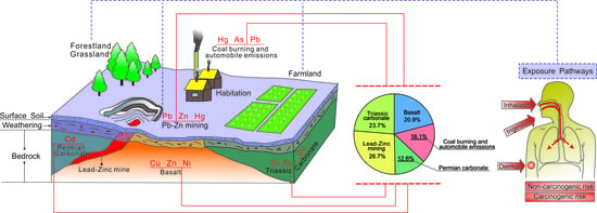
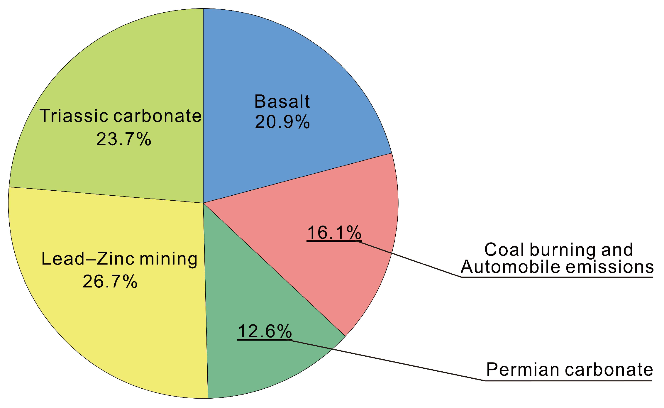
3.3. Source Identification of Metals by PMF

The distribution of potential ecological risks and human health risks shows that the soil heavy metals have multiple sources. To further determine the source of heavy metals and the contribution of each heavy metal to the pollution source in the surface soil of the study area, this research used the PMF [29] to identify the source of the eight heavy metals. All heavy metals were set to be strong according to the signal-to-noise ratio (S/N) to ensure the rationality of the model during the identification process; additionally, the operating factors were selected as 3, 4, and 5, and the running number was set to 20. The goodness-of-fit Q (robust) and Q (true) values obtained from the PMF model were the smallest and most stable when the number of running factors was 5, and the correlation coefficient between the observed and predicted concentration value (r2) of each heavy metal was the largest, which indicated that these five factors could comprehensive and reasonably reflect the information in the original data [8]. Figure 7 shows the analysis results for the eight heavy metals in the study area, and it is clear there are five main sources of heavy metals in the study area. These sources have different degrees of impact on the heavy metals in the surface soil.
Factor 1 has higher factor contributions of Cu, Zn, and Ni (contribution rates are 93.6%, 26.5%, and 23.8%, respectively). Over 20% of the study area has exposed basalt, and the distribution range of Cu and Ni anomalies in the soil is consistent with the widely exposed basalt in the area (Figure 2). Existing studies show that the spatial distribution pattern of Cu, Ni, and Zn in soils of southwestern China is mainly controlled by the distribution of Emeishan basalt [16,20], and the main morphological components of Cu and Ni in surface soil are in the residual fractions [19,60], which indicates that Cu, Ni, and Zn in the surface soil are inherited from the basalt parent rock. Therefore, Factor 1 is interpreted as a natural source caused by the geological background of Emeishan basalt in the study area.
Factor 2 is mainly related to Hg, As, and Pb (contribution rates are 75.6%, 23.9%, and 11.7%, respectively). Studies have shown that over 40% of Hg emissions in China are from anthropogenic sources caused by coal combustion [61], and atmospheric deposits produced by coal combustion are the main source of heavy metal As [62]. The research area of Zhaotong city is located at the border of Yunnan and Guizhou Provinces, which represent the main areas of coal production in southwest China. There are a large number of brown coal mines in Zhenxiong and Weixin in the district [63,64]. Slime, which is a mixture of coal, clay, and water, is the main domestic fuel in these rural areas, and a large amount of smoke dust is generated by coal combustion and residual coal ash and poured into the soil, causing the accumulation of heavy metals in soil. It is generally believed that the source of Pb is the emissions of automobile exhaust that enters the soil through atmospheric deposition; this Pb can remain in the soil environment for a long time [61,65]. It could be concluded that Factor 2 indicates a comprehensive source of pollution caused by atmospheric subsidence of coal burning and traffic emissions.
Factor 3 has the strongest correlation with Cd (the contribution rate is 85%), and the remaining heavy metals contribute less than 10% to this factor. Compared with the background value of soil (layer A) in China [14,15], Cd is the most enriched heavy metal in the study area, with an enrichment coefficient as high as 5.77. Ma et al. [59] believe that the accumulation of Cd in the soil of southwest China is mainly related to the exposed carbonate rocks in the area, and the spatial distribution of Cd in the study area suggests the same conclusion (Figure 2). Many research results have shown that the source of soil Cd is mainly related to agricultural production, such as pesticides and chemical fertilizers [66,67,68]; however, this study was not conducted on agricultural land, and 17.1% of all 28,095 soil samples that were collected were from forestland and grassland, which had no agricultural activity. A total of 40.2% of the samples came from the area where carbonate is exposed, in which the heavy metal Cd is highly enriched. In addition to Cd, there is no other heavy metal contribution in Factor 3; therefore, Factor 3 is considered to be the source of Permian carbonate rock.
Factor 4 is dominated by Pb, As, Zn, and Hg (contribution rates are 79.7%, 74.9%, 38.5%, and 11%, respectively). Commonly, soil from lead-zinc mining areas is enriched with Pb, Zn, and As from the mining of deposits [69,70,71,72,73]. In addition to the influence of parent materials such as basalt and carbonate rock, the medium–large lead–zinc mines distributed in the area have become an important main source of heavy metals in the soil. According to incomplete statistics, 86 lead–zinc mines have been identified in the study area, including 9 large mines. The proven reserves of lead–zinc mines in Zhaotong city of Yunnan Province exceed 700 × 104 tons, and Zhaotong and Qujing are the third and fourth largest cities, respectively, of lead and zinc resource reserves in Yunnan Province [74]. The spatial distribution of Pb, Zn, and As in the soil in the study area is consistent with the distribution of these known lead–zinc mining areas (Figure 2), which are mainly distributed in Yiliang, Zhenxiong, Qiaojia, and Huize, and these areas are also high-risk areas with soil that can potentially harm ecological and human health (Figure 3). Therefore, it is believed that Factor 4 mainly reflects the anthropogenic influence source of heavy metal accumulation caused by lead–zinc deposit mining activities.
Figure 7. Factor profiles and source contributions of heavy metals from the PMF model.
Toxics 10 00282 g007
Cr, Ni, and Zn are associated with Factor 5 (contribution rates are 97.4%, 65.5%, and 21.3%, respectively). Some researchers believe that the amounts of Cr, Ni, and Zn in the soil are controlled by the diagenetic parent rock and are related to the diagenetic composition [11,68]. The soil formed by weathered sediments of Triassic sedimentary rock in the study area showed more Cr concentrations than did the other sediments, even more than that in areas with basalt weathering, which accounted for 19.3% of the total number of samples. The inconsistent melting of orthopyroxene during the formation of the Emeishan basalt in the upper mantle is accompanied by Triassic volcanic activity, which leads to the depletion of the strong compatible element Cr in the basalt and the enrichment in the Triassic sedimentary rocks [75]. Furthermore, the results of soil morphological analysis of Cr, Ni, and Zn show that more than 80% of its composition is in the residual fractions [19,59], indicating that the source of heavy metals is mainly related to the parent rock. Therefore, it could be inferred that Factor 5 reflects the information of Triassic carbonate rocks in the study area.
In summary, the sources of heavy metals in the study area are mainly reflected by the above five factors, of which Factor 1, Factor 3, and Factor 5 are all natural sources, indicating information on the basalt and carbonate rocks in the study area; in contrast, Factor 2 and Factor 4 reflect anthropogenic sources, which indicate information on mining activities and atmospheric precipitation caused by coal burning and traffic emissions. The total contribution of the five factors followed a descending order: Factor 4 > Factor 5 > Factor 1 > Factor 2 > Factor 3 (Figure 8). Lead–zinc deposit mining activities have become the largest source of heavy metals in the study area, the contributions of other factors of heavy metal sources are relatively balanced. Factor 1, Factor 3, and Factor 5 are all natural sources, mainly caused by the geological background, but the higher carcinogenic risk that was identified deserves more attention. It is necessary to select several typical areas to strengthen the detailed investigation and the safety evaluation of agricultural products. This will help to obtain and understand the source and evolution information of soil heavy metals in local area.

4. Conclusions

Heavy metals show different levels of potential ecological risks in different land-use types, and the source of heavy metals in the area is complex and more or less restricted by types of land use. More importantly, the impact of industrial and mining land and farmland on ecological risk assessment is significant and it cannot be ignored.
Mining activities were one of the important factors affecting health risks posed by the soil. The contribution of the eight heavy metals to the HQ followed a descending order: As > Cd > Pb > Ni > Cu > Hg > Zn > Cr, and the three exposure pathways showed the following: HQdermal > HQingest > HQinhale. Cd and As are the main contributors to chronic health and carcinogenic risk in the study area; the heavy metals in the soil that cause these risks have multisource characteristics.
The soil heavy metals in the study area mainly comes from five sources, of which parent material such as basalt, Permian, and Triassic carbonate rock constitutes the natural geological background source, the mining activities of lead–zinc mines and the emissions of coal burning and automobile exhaust from residents constitute an anthropogenic source. The accumulation of heavy metals by mining activities contributed the most to the soil. The total contribution of the five sources followed a descending order: lead–zinc mining (26.7%) > Triassic carbonate (23.7%) > basalt (20.9) > coal burning and automobile emissions (16.1%) > Permian carbonate (12.6%).
The ecological risk assessment of areas with high geochemical background should focus on the analysis and understanding of the geological background, combined with the comprehensive judgment of the results of pollutant source analysis. Based on the different exposure pathways, the impact of human activities on health risk assessment is crucial. These results provide basic information on the study of heavy metals and guidance on the selection of natural source treatment options in the high geochemical background area of southwest China.

Author Contributions

Conceptualization, Z.C., J.X. and F.Y.; methodology, Z.C., R.D., F.Y. and M.P.; writing—original draft preparation, Z.C., J.X., S.L. and Z.H.; writing—review and editing, Z.C., Z.S. and S.L.; visualization, Z.C., Q.Z. and Z.H.; supervision, R.D., Z.S. and L.Y.; funding acquisition, M.P. All authors have read and agreed to the published version of the manuscript.

Funding

This research was funded by the Opening Fund of Provincial Key Lab of Applied Nuclear Techniques in Geosciences (Grant No. gnzds201906), Project of China Geological Survey (Grant No. 121201108000150008-04, DD20160313-04, DD20190522-01-1, DD20190522-06-1).

Institutional Review Board Statement

Not applicable.

Informed Consent Statement

Not applicable.

Data Availability Statement

The data presented in this study are available on request from the corresponding authors. The processed data are not publicly available as the data also form part of an ongoing study.

Acknowledgments

The authors would like to thank the editors and reviewers for their valuable comments and suggestions.

Conflicts of Interest

The authors declare no conflict of interest.

References

  1. USEPA. Framework for Ecological Risk Assessment; US Environmental Protection Agency: Washington, DC, USA, 1992. Available online: https://www.epa.gov/risk/framework-ecological-risk-assessment (accessed on 5 May 2020).
  2. Hu, W.Y.; Huang, B.; He, Y.; Kalkhajeh, Y.K. Assessment of potential health risk of heavy metals in soils from a rapidly developing region of China. Hum. Ecol. Risk Assess. Int. J. 2016, 22, 211–225. [Google Scholar] [CrossRef]
  3. Zhao, H.R.; Xia, B.C.; Fan, C.; Zhao, P.; Shen, S.L. Human health risk from soil heavy metal contamination under different land uses near Dabaoshan mine, Southern China. Sci. Total Environ. 2012, 417–418, 45–54. [Google Scholar] [CrossRef]
  4. Niemeyer, J.C.; Lolata, G.B.; De-Carvalho, G.M.; Da-Silvab, E.M.; Sousa, J.P.; Nogueira, M.A. Microbial indicators of soil health as tools for ecological risk assessment of a metal contaminated site in Brazil. Appl. Soil Ecol. 2012, 59, 96–105. [Google Scholar] [CrossRef]
  5. Liu, G.N.; Yu, Y.J.; Hou, J.; Xue, W.; Liu, X.H.; Liu, Y.Z.; Wang, W.H.; Alsaedi, A.; Hayat, T.; Liu, Z.T. An ecological risk assessment of heavy metal pollution of the agricultural ecosystem near a lead-acid battery factory. Ecol. Indic. 2014, 47, 210–218. [Google Scholar] [CrossRef]
  6. El-Azhari, A.; Rhoujjati, A.; El-Hachimi, M.L.; Ambrosi, J. Pollution and ecological risk assessment of heavy metals in the soil-plant system and the sediment-water column around a former Pb/Zn-mining area in NE Morocco. Ecotoxicol. Environ. Saf. 2017, 144, 464–474. [Google Scholar] [CrossRef]
  7. Jiang, Y.X.; Chao, S.H.; Liu, J.W.; Yang, Y.; Chen, Y.J.; Zhang, A.C.; Cao, H.B. Source apportionment and health risk assessment of heavy metals in soil for a township in Jiangsu Province, China. Chemosphere 2017, 168, 1658–1668. [Google Scholar] [CrossRef]
  8. Guan, Q.Y.; Wang, F.F.; Xu, C.Q.; Pan, N.H.; Lin, J.K.; Zhao, R.; Yang, Y.Y.; Luo, H.P. Source apportionment of heavy metals in agricultural soil based on PMF: A case study in Hexi Corridor, northwest China. Chemosphere 2018, 193, 189–197. [Google Scholar] [CrossRef]
  9. Hu, W.Y.; Wang, H.F.; Dong, L.R.; Huang, B.; Borggaard, O.K.; Hansen, H.C.B.; He, Y.; Holm, P.E. Source identification of heavy metals in peri-urban agricultural soils of southeast China: An integrated approach. Environ. Pollut. 2018, 237, 650–661. [Google Scholar] [CrossRef] [PubMed]
  10. Borah, P.; Singh, P.; Rangan, L.; Karak, T.; Mitra, S. Mobility, bioavailability and ecological risk assessment of cadmium and chromium in soils contaminated by paper mill wastes. Groundw. Sustain. Dev. 2018, 6, 189–199. [Google Scholar] [CrossRef]
  11. Lv, J.S.; Wang, Y.M. PMF receptor models and sequential Gaussian simulation to determine the quantitative sources and hazardous areas of potentially toxic elements in soils. Geoderma 2019, 353, 347–358. [Google Scholar] [CrossRef]
  12. Huang, J.H.; Peng, S.Y.; Mao, X.M.; Li, F.; Guo, S.T.; Shi, L.X.; Shi, Y.H.; Yu, H.B.; Zeng, G.M. Source apportionment and spatial and quantitative ecological risk assessment of heavy metals in soils from a typical Chinese agricultural county. Process Saf. Environ. Prot. 2019, 126, 339–347. [Google Scholar] [CrossRef]
  13. Xiao, R.; Guo, D.; Ali, A.; Mi, S.S.; Liu, T.; Ren, C.Y.; Li, R.H.; Zhang, Z.Q. Accumulation, ecological-health risks assessment, and source apportionment of heavy metals in paddy soils: A case study in Hanzhong, Shaanxi, China. Environ. Pollut. 2019, 248, 349–357. [Google Scholar] [CrossRef]
  14. CEMS (China Environmental Monitoring Station). Soil Element Background Values of China; China Environmental Science Press: Beijing, China, 1990. [Google Scholar]
  15. Wei, F.S.; Chen, J.S.; Wu, Y.Y.; Zhen, C.J. Research on soil environmental background value in China. Environ. Sci. 1991, 12, 12–19. [Google Scholar] [CrossRef]
  16. Cheng, H.X.; Peng, M.; Zhao, C.D.; Han, W.; Wang, H.Y.; Wang, Q.L.; Yang, F.; Zhang, F.G.; Wang, C.W.; Liu, F.; et al. Epigenetic geochemical dynamics and driving mech-anisms of chemical elemental distribution patterns in soil in Southwest China. Earth Sci. Front. 2019, 26, 159–191. [Google Scholar] [CrossRef]
  17. Hseu, Z.Y.; Lai, Y.J. Nickel accumulation in paddy rice on serpentine soils containing high geogenic nickel concentrations in Taiwan. Environ. Geochem. Health 2017, 39, 1325–1334. [Google Scholar] [CrossRef]
  18. Liu, Y.Z.; Xiao, T.F.; Perkins, R.B.; Zhu, J.M.; Zhu, Z.J.; Xiong, Y.; Ning, Z.P. Geogenic cadmium pollution and potential health risks, with emphasis on black shale. J. Geochem. Explor. 2017, 176, 42–49. [Google Scholar] [CrossRef] [Green Version]
  19. Wen, Y.B.; Li, W.; Yang, Z.F.; Zhang, Q.Z.; Ji, J.F. Enrichment and source identification of Cd and other heavy metals in soils with high geochemical background in the karst region, Southwestern China. Chemosphere 2020, 245, 125620. [Google Scholar] [CrossRef]
  20. Wang, H.X.; Li, X.M.; Chen, Y.; Li, Z.B.; Hedding, D.W.; Nel, W.; Ji, J.F.; Chen, J. Geochemical behavior and potential health risk of heavy metals in basalt-derived agricultural soil and crops: A case study from Xuyi county, eastern China. Sci. Total Environ. 2020, 729, 139058. [Google Scholar] [CrossRef]
  21. Zeng, G.; Chen, L.H.; Hu, S.L.; Xu, X.S.; Yang, L.F. Genesis of Cenozoic low-Ca alkaline basalts in the Nanjing basaltic field, eastern China: The case for mantle xenolith-magma interaction. Geochem. Geophys. Geosystems 2013, 14, 1660–1677. [Google Scholar] [CrossRef]
  22. Rudnick, R.L.; Gao, S. Composition of the continental crust. In Treatise on Geochemistry, 2nd ed.; Holland, H.D., Turekian, K.K., Eds.; Elsevier, Ltd.: Amsterdam, The Netherlands, 2014. [Google Scholar]
  23. Wu, J.; Li, J.; Teng, Y.G.; Chen, H.Y.; Wang, Y.Y. A partition computing-based positive matrix factorization (PC-PMF) approach for the source apportionment of agricultural soil heavy metal contents and associated health risks. J. Hazard. Mater. 2020, 388, 121766. [Google Scholar] [CrossRef]
  24. USEPA. Framework for Metals Risk Assessment; US Environmental Protection Agency: Washington, DC, USA, 2007. Available online: https://nepis.epa.gov/Exe/ZyPURL.cgi?Dockey=60000GSQ.txt (accessed on 5 May 2020).
  25. Luo, W.; Lu, Y.L.; Giesy, J.P.; Wang, T.Y.; Shi, Y.J.; Wang, G.; Xing, Y. Effects of land use on concentrations of metals in surface soils and ecological risk around Guanting Reservoir, China. Environ. Geochem. Health 2007, 29, 459–471. [Google Scholar] [CrossRef]
  26. Xu, J.C.; Sharma, R.; Fang, J.; Xu, Y.F. Critical linkages between land-use transition and human health in the Himalayan region. Environ. Int. 2008, 34, 239–247. [Google Scholar] [CrossRef]
  27. Islam, S.; Ahmed, K.; Al-Mamun, H.; Masunaga, S. Potential ecological risk of hazardous elements in different land-use urban soils of Bangladesh. Sci. Total Environ. 2015, 512–513, 94–102. [Google Scholar] [CrossRef]
  28. Zong, Q.X.; Dou, L.; Hou, Q.Y.; Yang, Z.F.; You, Y.H.; Tang, Z.M. Regional ecological risk assessment of soil heavy metals in Pearl River Delta economic zone based on different land uses. Adv. Earth Sci. 2017, 32, 875–884. [Google Scholar] [CrossRef]
  29. USEPA. EPA Positive Matrix Factorization (PMF) 5.0 Fundamentals and User Guide; US Environmental Protection Agency: Washington, DC, USA, 2014. Available online: https://nepis.epa.gov/Exe/ZyPURL.cgi?Dockey=P100IW74.txt (accessed on 5 May 2020).
  30. Zhao, Q.G.; Yang, Z.S.; Xing, L. The Second National Land Surver Report of Yunnan Province; China Science and Technology Press: Beijing, China, 2015. [Google Scholar]
  31. MLRPRC. Specification of Multi-Purpose Regional Geochemical Survey (DZ/T 0258-2014); Ministry of Land and Resources of the People’s Republic of China: Beijing, China, 2014.
  32. Hakanson, L. An ecological risk index for aquatic pollution control. a sedimentological approach. Water Res. 1980, 14, 975–1001. [Google Scholar] [CrossRef]
  33. Yuan, G.L.; Sun, T.H.; Han, P.; Li, J.; Lang, X.X. Source identification and ecological risk assessment of heavy metals in topsoil using environmental geochemical mapping: Typical urban renewal area in Beijing, China. J. Geochem. Explor. 2014, 136, 40–47. [Google Scholar] [CrossRef]
  34. USEPA. Guidelines for the Health Risk Assessment of Chemical Mixtures; US Environmental Protection Agency: Washington, DC, USA, 1986. Available online: https://www.epa.gov/risk/guidelines-health-risk-assessment-chemical-mixtures (accessed on 5 May 2020).
  35. USEPA. Risk Assessment Guidance for Superfund: Volume 1—Human Health Evaluation Manual (Part A); US Environmental Protection Agency: Washington, DC, USA, 1989. Available online: https://nepis.epa.gov/Exe/ZyPURL.cgi?Dockey=9100UGV0.txt (accessed on 5 May 2020).
  36. USEPA. Supplemental Guidance for Developing Soil Screening Levels for Superfund Sites; US Environmental Protection Agency: Washington, DC, USA, 2002. Available online: https://nepis.epa.gov/Exe/ZyPURL.cgi?Dockey=91003IJK.txt (accessed on 5 May 2020).
  37. Huang, J.H.; Liu, W.C.; Zeng, G.M.; Li, F.; Huang, X.L.; Gu, Y.L.; Shi, L.X.; Shi, Y.H.; Wan, J. An exploration of spatial human health risk assessment of soil toxic metals under different land uses using sequential indicator simulation. Ecotoxicol. Environ. Saf. 2016, 129, 199–209. [Google Scholar] [CrossRef] [PubMed]
  38. Chen, T.B. Regional Soil Environment Quality; Science Press: Beijing, China, 2015. [Google Scholar]
  39. Chen, H.Y.; Teng, Y.G.; Lu, S.J.; Wang, Y.Y.; Wang, J.S. Contamination features and health risk of soil heavy metals in China. Sci. Total Environ. 2015, 512–513, 143–153. [Google Scholar] [CrossRef]
  40. Liu, X.M.; Song, Q.J.; Tang, Y.; Li, W.L.; Xu, J.M.; Wu, J.J.; Wang, F.; Brookes, C.P. Human health risk assessment of heavy metals in soil–vegetable system: A multi-medium analysis. Sci. Total Environ. 2013, 463–464, 530–540. [Google Scholar] [CrossRef]
  41. NBSPRC. The Sixth National Population Census Basic Statistics of Yunnan Province; National Bureau of Statistics of People’s Republic of China: Beijing, China, 2019. Available online: http://www.yn.gov.cn/zwgk/zfxxgkpt/fdzdgknr/tjxx/ntjnj/202003/t20200327_201263.html (accessed on 5 May 2020).
  42. USEPA. Exposure Factors Handbook; National Center for Environmental Assessment: Washington, DC, USA, 2011. Available online: https://ordspub.epa.gov/ords/eims/eimscomm.getfile?p_download_id=522996 (accessed on 5 May 2020).
  43. HC. Federal Contaminated Site Risk Assessment in Canada-Part II: Health Canada Toxicological Reference Values (TRVs) and Chemical-Specific Factors; Health Canada: Ottawa, ON, Canada, 2004.
  44. USEPA. Regional Screening Levels (RSLs)-Generic Tables; US Environmental Protection Agency: Washington, DC, USA, 2019. Available online: https://www.epa.gov/risk/regional-screening-levels-rsls-generic-tables (accessed on 5 May 2020).
  45. NHCPRC. Report on Nutrition and Chronic Diseases Status of Chinese Residents; National Health Commission of the People’s Republic of China: Beijing, China, 2015. Available online: http://www.nhc.gov.cn/jkj/s5879/201506/4505528e65f3460fb88685081ff158a2.shtml (accessed on 5 May 2020).
  46. Ferreira-Baptista, L.; De-Miguel, E. Geochemistry and risk assessment of street dust in Luanda, Angola: A tropical urban environment. Atmos. Environ. 2005, 39, 4501–4512. [Google Scholar] [CrossRef] [Green Version]
  47. SEPAC. Technical Guidelines for Risk Assessment of Contaminated Sites; State Environment Protection Administration of China: Beijing, China, 2009. Available online: https://www.mee.gov.cn/gkml/hbb/bgth/200910/W020091009550671751947.pdf (accessed on 5 May 2020).
  48. Lü, J.; Jiao, W.B.; Qiu, H.Y.; Chen, B.; Huang, X.X.; Kang, B. Origin and spatial distribution of heavy metals and carcinogenic risk assessment in mining areas at You’xi county southeast China. Geoderma 2018, 310, 99–106. [Google Scholar] [CrossRef]
  49. IRIS USEPA. Integrated Risk Information System of the US Environmental Protection Agency; US Environmental Protection Agency: Washington, DC, USA, 2012. Available online: https://iris.epa.gov/ChemicalLanding/&substance_nmbr=277 (accessed on 5 May 2020).
  50. Li, Z.Y.; Ma, Z.W.; Tsering, J.; Yuan, Z.W.; Huang, L. A review of soil heavy metal pollution from mines in China: Pollution and health risk assessment. Sci. Total Environ. 2014, 468–469, 843–853. [Google Scholar] [CrossRef]
  51. Michael, A. Soil elemental concentrations, geoaccumulation index, noncarcinogenic and carcinogenic risks in functional areas of an informal e-waste recycling area in Accra, Ghana. Chemosphere 2019, 235, 908–917. [Google Scholar] [CrossRef]
  52. USEPA. Risk Assessment Guidance for Superfund: Volume III–Part A, Process for Conducting Probabilistic Risk Assessment; US Environmental Protection Agency: Washington, DC, USA, 2001. Available online: https://www.epa.gov/risk/risk-assessment-guidance-superfund-rags-volume-iii-part (accessed on 5 May 2020).
  53. Guney, M.; Zagury, G.J.; Dogan, N.; Onay, T.T. Exposure assessment and risk characterization from trace elements following soil ingestion by children exposed to playgrounds, parks and picnic areas. J. Hazard. Mater. 2010, 182, 656–664. [Google Scholar] [CrossRef]
  54. USEPA. Regional Removal Management Levels for Chemicals (RMLs); US Environmental Protection Agency: Washington, DC, USA, 2001. Available online: https://www.epa.gov/risk/regional-removal-management-levels-chemicals-rmls (accessed on 5 May 2022).
  55. Saleem, M.; Iqabal, J.; Shah, M.H. Non-carcinogenic and carcinogenic health risk assessment of selected metals in soil around a natural water reservoir, Pakistan. Ecotoxicol. Environ. Saf. 2014, 108, 42–51. [Google Scholar] [CrossRef]
  56. Chavent, M.; Guegan, H.; Kuentz, V.; Patouille, B.; Saracco, J. PCA and PMF based methodology for air pollution sources identification and apportionment. Environmetrics 2008, 20, 928–942. [Google Scholar] [CrossRef] [Green Version]
  57. Jang, E.; Alam, M.S.; Harrison, R.M. Source apportionment of polycyclic aromatic hydrocarbons in urban air using positive matrix factorization and spatial distribution analysis. Atmos. Environ. 2013, 79, 271–285. [Google Scholar] [CrossRef]
  58. Zhou, Y.L.; Guo, Z.J.; Wang, C.W.; Chen, J.; Peng, M.; Cheng, H.X. Assessment of heavy metal pollution and potential ecological risks of soils in Zhenxiong county, Yunnan Province. Geophys. Geochem. Explor. 2019, 43, 1358–1366. [Google Scholar] [CrossRef]
  59. Ma, H.H.; Peng, M.; Liu, F.; Guo, F.; Tang, S.Q.; Liu, J.Q.; Zhou, Y.L.; Yang, K.; Li, K.; Yang, Z.; et al. Bioavailability, translocation, and accumulation characteristic of heavy metals in a soil-crop system from a typical carbonate rock area in Guangxi, China. Environ. Sci. 2020, 41, 449–459. [Google Scholar] [CrossRef]
  60. Zhang, F.G.; Peng, M.; Wang, H.Y.; Ma, H.H.; Xu, R.T.; Cheng, X.M.; Hou, Z.L.; Chen, Z.W.; Li, K.; Cheng, H.X. Ecological risk assessment of heavy metals Ao township scale in the high background of heavy metals, Southwestern, China. Environ. Sci. 2020, 41, 4197–4209. [Google Scholar] [CrossRef]
  61. Huang, Y.; Deng, M.H.; Li, T.Q.; Japenga, J.; Chen, Q.Q.; Yang, X.E.; He, Z.L. Anthropogenic mercury emissions from 1980 to 2012 in China. Environ. Pollut. 2017, 226, 230–239. [Google Scholar] [CrossRef]
  62. Huang, Y.; Li, T.Q.; Wu, C.X.; He, Z.L.; Japenga, J.; Deng, M.H.; Yang, X.E. An integrated approach to assess heavy metal source apportionment in peri-urban agricultural soils. J. Hazard. Mater. 2015, 299, 540–549. [Google Scholar] [CrossRef]
  63. Ren, D.Y.; Zhao, F.H.; Wang, Y.Q.; Yang, S.J. Distributions of minor and trace elements in Chinese coals. Int. J. Coal Geol. 1999, 40, 109–118. [Google Scholar] [CrossRef]
  64. Dai, S.F.; Ren, D.Y.; Hou, X.Q.; Shao, L.Y. Geochemical and mineralogical anomalies of the late Permian coal in the Zhijin coalfield of Southwest China and their volcanic origin. Int. J. Coal Geol. 2003, 55, 117–138. [Google Scholar] [CrossRef]
  65. Zhao, L.S.; Hu, G.R.; Yan, Y.; Yu, R.L.; Cui, J.Y.; Wang, X.M.; Yan, Y. Source apportionment of heavy metals in urban road dust in a continental city of eastern China: Using Pb and Sr isotopes combined with multivariate statistical analysis. Atmos. Environ. 2019, 201, 201–211. [Google Scholar] [CrossRef]
  66. Lu, A.X.; Wang, J.H.; Qin, X.Y.; Wang, K.Y.; Han, P.; Zhang, S.Z. Multivariate and geostatistical analyses of the spatial distribution and origin of heavy metals in the agricultural soils in Shunyi, Beijing, China. Sci. Total Environ. 2012, 425, 66–74. [Google Scholar] [CrossRef]
  67. Lv, J.S.; Liu, Y.; Zhang, Z.L.; Dai, J.R.; Dai, B.; Zhu, Y.C. Identifying the origins and spatial distributions of heavy metals in soils of Ju country (Eastern China) using multivariate and geostatistical approach. J. Soils Sediments 2015, 15, 163–178. [Google Scholar] [CrossRef]
  68. Mico, C.; Recatala, L.; Peris, M.; Sanchez, J. Assessing heavy metal sources in agricultural soils of an European Mediterranean area by multivariate analysis. Chemosphere 2006, 65, 863–872. [Google Scholar] [CrossRef]
  69. Conesa, H.M.; Faz, Á.; Arnaldos, R. Initial studies for the phytostabilization of a mine tailing from the Cartagena-La Union Mining District (SE Spain). Chemosphere 2007, 66, 38–44. [Google Scholar] [CrossRef]
  70. Li, P.Z.; Lin, C.Y.; Cheng, H.G.; Duan, X.L.; Lei, K. Contamination and health risks of soil heavy metals around a lead/zinc smelter in southwestern China. Ecotoxicol. Environ. Saf. 2015, 113, 391–399. [Google Scholar] [CrossRef]
  71. Zhuang, P.; McBride, M.B.; Xia, H.P.; Li, N.Y.; Li, Z.A. Health risk from heavy metals via consumption of food crops in the vicinity of Dabaoshan mine, South China. Sci. Total Environ. 2009, 407, 1551–1561. [Google Scholar] [CrossRef] [PubMed]
  72. Zhou, Y.; Chen, Q.; Deng, S.P.; Wan, J.Z.; Zhang, S.T.; Long, T.; Li, Q.; Lin, Y.S.; Wu, Y.J. Principal component analysis and ecological risk assessment of heavy metals in farmland soils around a Pb-Zn Mine in southwestern China. Environ. Sci. 2018, 39, 2884–2892. [Google Scholar] [CrossRef]
  73. Zhu, G.X.; Xiao, H.Y.; Guo, Q.J.; Song, B.; Zheng, G.D.; Zhang, Z.Y.; Zhao, J.J.; Okoli, C.P. Heavy metal contents and enrichment characteristics of dominant plants in wasteland of the downstream of a lead-zinc mining area in Guangxi, Southwest China. Ecotoxicol. Environ. Saf. 2018, 151, 266–271. [Google Scholar] [CrossRef] [PubMed]
  74. Chen, Y.C.; Wang, D.H. China Mineral Geology (Yunnan Volume)—Lead and Zinc Minerals; China Geological Publishing House: Beijing, China, 2018. [Google Scholar]
  75. Jiang, H.B.; Jiang, C.Y.; Qian, Z.Z.; Zhu, S.F.; Zhang, P.B.; Tang, D.M. Petrogenesis of high-Ti and low-Ti basalts in Emeishan, Yunnan, China. Acta Petrol. Sin. 2009, 25, 1117–1134. [Google Scholar]
Figure 1. Location map of the study area.
Toxics 10 00282 g001
Figure 3. Spatial distribution of the compound ecological risk index (RI) (a) and hazard index (HI) (b) of heavy metals in surface soil.
Toxics 10 00282 g003
Figure 4. Average values of the potential ecological risk index ( E r i ) (a) and hazard quotient (HQ) (b) of heavy metals in the study area.
Toxics 10 00282 g004
Figure 5. Average ecological risk index ( E r i ) of heavy metals in different land uses.
Toxics 10 00282 g005
Figure 8. Contributions rates of different sources by PMF.
Toxics 10 00282 g008
Table 1. Reference values of biological toxicity response factors of heavy metals.
Heavy MetalsAsCrCdCuPbNiZnHgReferences
Toxic response factors10230555140[32,33]
Table 2. Exposure parameters used to characterize the chronic daily intake (CDI) of heavy metals.
SymbolParameterValueUnitReferences
IRingIngestion rate100mg·day−1[36]
IRinhInhalation rate12.8m3·day−1[42]
EFExposure frequencyFarmland and residential land350day·a−1[36]
Industrial and mining land250[38]
Forestland and other types40
EDExposure durationNon-carcinogenic risk24a[36]
Carcinogenic risk69.5[41]
SAExposed skin area5700cm2[36]
SLSkin adherence factor0.07mg·(cm2·day)−1[36]
ABSDermal absorption factor0.03 (As), 0.001 (Cd),
0.04 (Cr), 0.10 (Cu),
0.05 (Hg), 0.35 (Ni),
0.006 (Pb), 0.02 (Zn)
unitless[43,44]
PEFParticle emission factor1.36 × 109m3·kg−1[36]
ATAverage exposure timeED × 365days[36]
BWAverage bodyweight62kg[45]
CFConversion factor1.00 × 10−6unitless[42]
Table 3. Reference dose (RfD) and carcinogenic slope factor (CSF) of heavy metals for three exposure pathways.
Heavy
Metals
RfD/mg·(kg·d)−1CSF/mg·(kg·d)−1
RfDingestRfDinhaleRfDdermalCSFingestCSFinhaleCSFdermal
As3.00 × 10−4 [44]1.50 × 10⁻⁵ [44]1.23 × 10⁻⁴ [46]1.50 × 100 [44]1.51 × 101 [46]1.50 × 10−0 [47]
Cd1.00 × 10−3 [44]1.00 × 10⁻⁵ [44]1. × 10−5 [46]6.10 × 100 [48]1.47 × 101 [47]2.44 × 10² *
Cr1.50 × 100 [42]1.50 × 100 **1.50 × 100 ** 4.20 × 101 [46]
Cu4.00 × 10−2 [44]4.00 × 10⁻² **1.20 × 10⁻² [46]
Hg3.00 × 10−4 [44]3.00 × 10⁻⁴ [44]2.10 × 10⁻⁵ [46]
Ni2.00 × 10−2 [44]9.00 × 10⁻⁵ [44]5.40 × 10⁻³ [46]
Pb3.50 × 10−3 [46]3.50 × 10⁻³ **5.25 × 10⁻⁴ [46]8.50 × 10⁻³ [49]4.20 × 10⁻² [47]8.50 × 10⁻³ *
Zn3.00 × 10−1 [44]3.00 × 10⁻¹ **6.00 × 10⁻² [46]
* Get by CSFdermal = CSFingest/ABSGI [44]; ** Use the RfDingest instead.
Publisher’s Note: MDPI stays neutral with regard to jurisdictional claims in published maps and institutional affiliations.

