
Planning Perspectives and Approaches for Activating Underground Built Heritage

 , , , , and
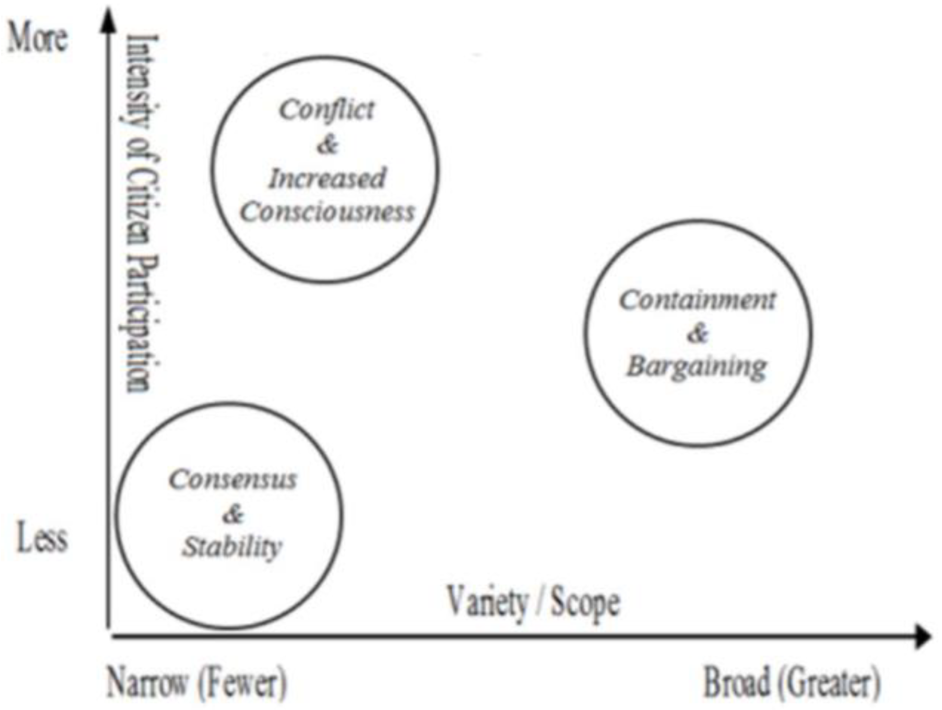
Abstract
:1. Introduction
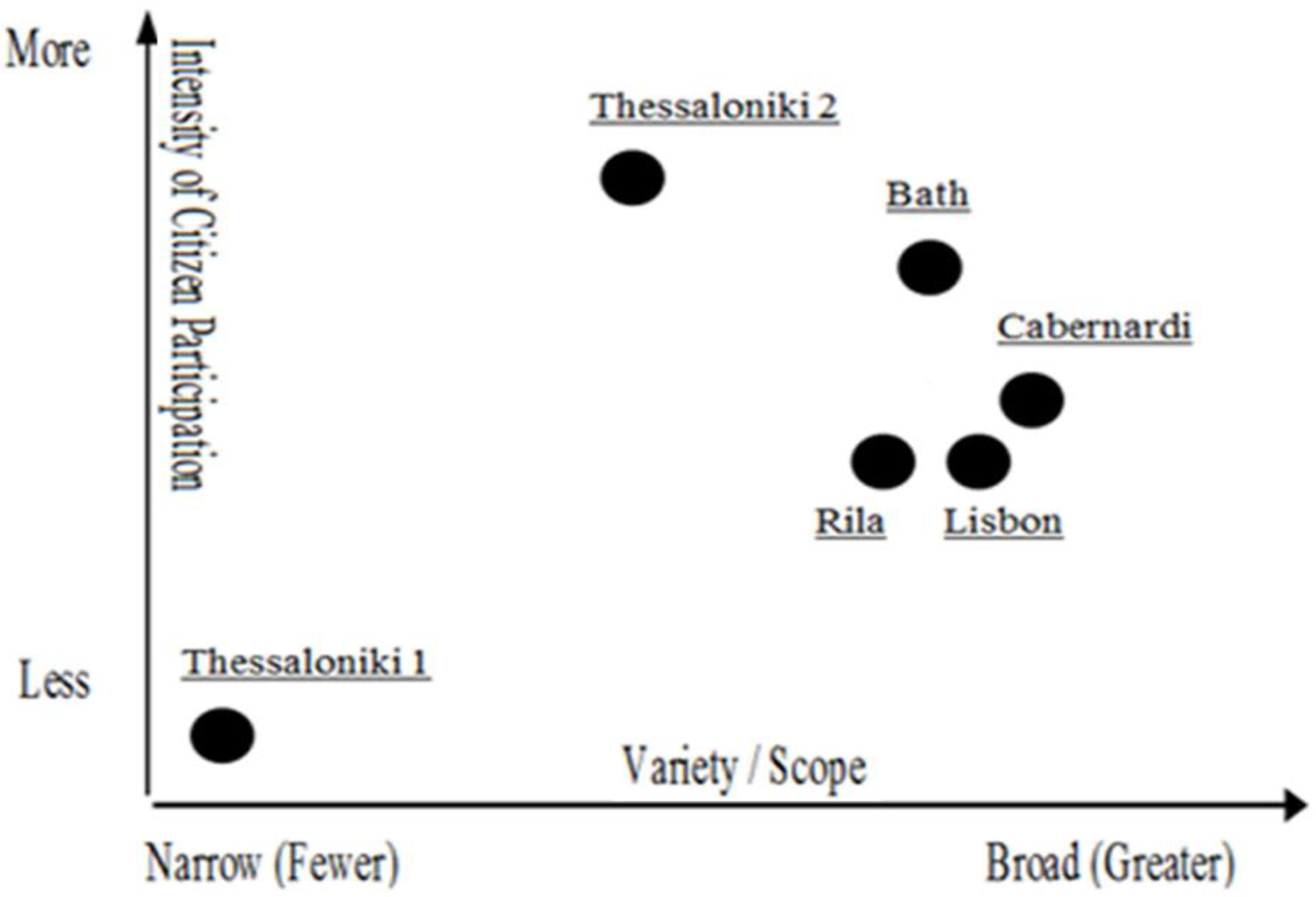
2. Framework
3. Materials and Method
3.1. Cases Selection
3.2. Method
4. Five Cases—Challenges and Achievements
4.1. Quality Assessment of Rila Monastery Nature Park, Bulgaria
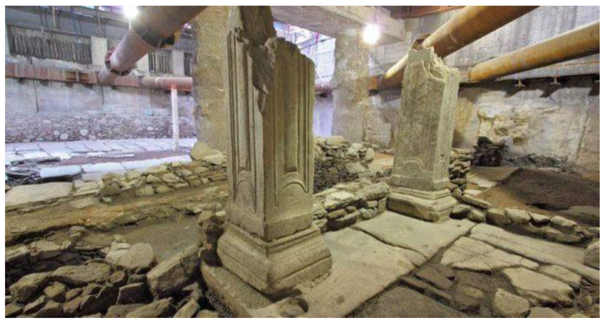
4.2. Archaeological Excavations in Thessaloniki Metro, Greece
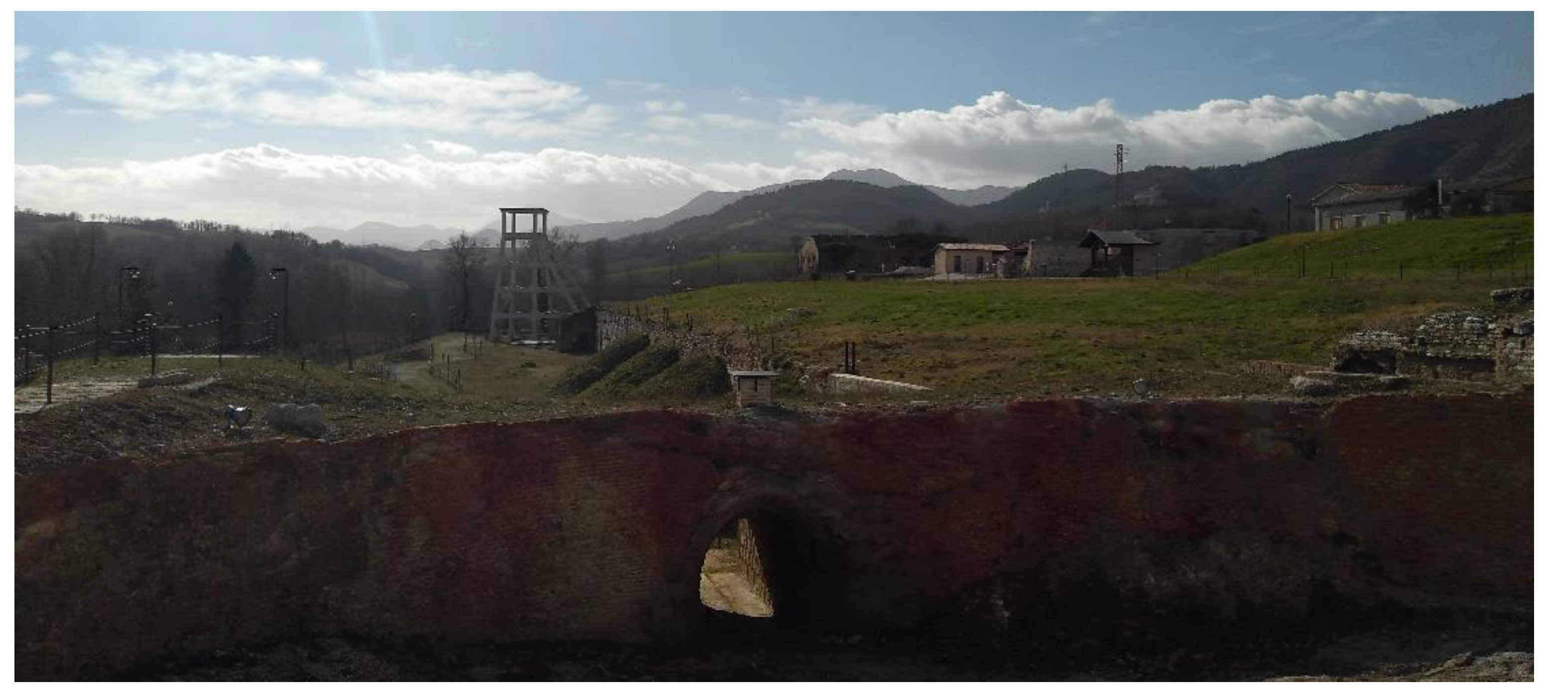
4.3. Building Collective Memory on Cabernardi Sulphur Mine, Sassoferrato, Italy
4.4. Public Art Gallery in Lisbon Subway Stations, Portugal
4.5. Stabilisation of Underground Mines at Combe Down, Bath, UK
- The mine was home for large numbers of rare and legally protected bats.
- It lies in the groundwater Inner Source Protection Zone of a public water supply.
- There was legally protected archaeological heritage within the mine itself.
5. Planning Perspectives, Approaches and Bottlenecks: Framing the Debate
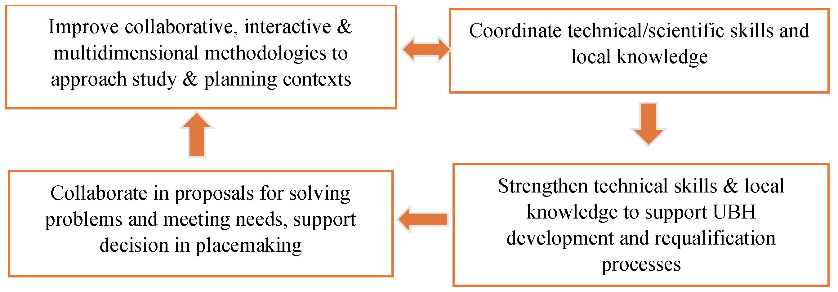
6. Building a Rationale for Activating UBH
- Key stakeholders (including identification of their main characteristics, interests and potential forms of collaboration).
- Types/forms of representations of individuals/groups (considering the heterogeneity of practices and socio-demographic characteristics).
- UBH assets (including identification of the asset, its surroundings and its interrelations (i.e., between the private and public spaces) and considering spaces to be involved and mobilized in the intervention).
7. Concluding Remarks
Author Contributions
Funding
Institutional Review Board Statement
Informed Consent Statement
Data Availability Statement
Conflicts of Interest
References
- Underground4value, Memorandum of Understanding for the Implementation of the COST Action CA18110 Underground Built Heritage as Catalyser for Community Valorisation (Underground4value). 2018. Available online: https://www.cost.eu/actions/CA18110 (accessed on 30 August 2021).
- Pace, G.; Salvarani, R. (Eds.) Underground Built Heritage Valorisation. A Handbook; CNR: Rome, Italy, 2021. [Google Scholar]
- Underground4value, Working Group: Underground Built Heritage Planning Approaches. Underground Built Heritage Planning Approaches. Available online: https://underground4value.eu/wg4-underground-built-heritage-planning-approaches (accessed on 30 August 2021).
- Smaniotto Costa, C. Touching Green—Reflections on Public Spaces and Nature in the Digital Era. In Hybrid Heritagescapes as Urban Commons in Mediterranean Cities: Essays on Accessing the Deep-Rooted Spatial Interfaces of Cities: 101–106; Artopoulos, G., Ed.; The Cyprus Institute: Nicosia, Cyprus, 2018. [Google Scholar]
- Lalenis, K. Public Participation Strategies in Urban. Planning in Greece after the “Urban. Reconstruction Operation (EPA) 1982–1984. Comparison of Theory and Practice. Ph.D. Thesis, University of Westminster, London, UK, 1993. [Google Scholar]
- Thornley, A. Theoretical perspectives on planning participation. Prog. Plan. 1977, 7, 1–57. [Google Scholar] [CrossRef]
- Cole, R. Citizen Participation in the Urban Policy Process; Lexington Books: Lexington, MA, USA, 1973. [Google Scholar]
- Lalenis, K. A Handbook on Territorial Democracy and Public Participation in Spatial Planning. Council of Europe. 2015. Available online: http://www.ypeka.gr/Portals/0/Files/Xorotaxia%20,,2015kai%20Astiko%20Perivallon/Xorotaxia/Diethnes%20Plaisio/CE_Handbook_A5_2.pdf (accessed on 19 December 2020).
- Tuvikene, T.; Alves, S.N.; Hilbrandt, H. Strategies for relating diverse cities: A multi-sited individualising comparison of informality in Bafatá, Berlin and Tallinn. Curr. Sociol. 2017, 65, 276–288. [Google Scholar] [CrossRef]
- Gerring, J.; Cojocaru, L. Selecting Cases for Intensive Analysis: A Diversity of Goals and Methods. Sociol. Methods Res. 2016, 45, 392–423. [Google Scholar] [CrossRef]
- Kantor, P.; Savitch, H.V. How to Study Comparative Urban Development Politics: A Research Note. Int. J. Reg. Urban Res. 2005, 29, 135–151. [Google Scholar] [CrossRef]
- Nijman, J. Introduction—Comparative Urbanism. Urban Geogr. 2007, 28, 1–6. [Google Scholar] [CrossRef]
- Flyvbjerg, B. Five misunderstandings about case study research. Qual. Inq. 2006, 12, 219–245. [Google Scholar] [CrossRef] [Green Version]
- Radovanova, P.; Samardjieva, M.; Velichkov, V. Rapid Landscape Assessment of the territory of Rila Monastery Nature Park, Section IV Landscape assessment and Socio-economic characteristics. In Rapid Ecological Assessment of Rila Monastery Nature Park; Peev, D., Ed.; Report Published by the USAID; Ministry of Environment and Waters of Republic of Bulgaria: Sofia, Bulgaria, 2003; pp. 166–175. [Google Scholar]
- Yankov, P. Assessment and its application for Rila Monastery Nature Park; 12-16, Section I “Rapid Landscape Assessment”. In Rapid Ecological Assessment of Rila Monastery Nature Park; Report Published by the USAID; Ministry of Environment and Waters of Republic of Bulgaria: Sofia, Bulgaria, 2003. [Google Scholar]
- Coles, R.; Radovanova, P. Urban open space provision in Sofia and possibility for application of urban and community forest. In 75 Years Forest Technical Education in Bulgaria, Section Landscape Architecture and Economic Management; Ministry of Environment and Waters of Republic of Bulgaria: Sofia, Bulgaria, 2000; pp. 92–98. [Google Scholar]
- CoE. Conseil de l’Europe. Convention Européenne du Paysage; STE 176: Strasbourg, France, 2000. [Google Scholar]
- Dolgov, K.M. Estetika Prirodoj. Available online: http://philosophy.ru/iphras/library/estpri.html (accessed on 2 September 2020).
- Robev, R. Views and Arrangements in Landscape Management and Planning; National Centre for Scientific Information: Sofia, Bulgaria, 1977. [Google Scholar]
- Kostadinova, S. Trends in tourism and the use of non-timber natural resources, Section IV Landscape assessment and Socio-economic characteristics. In Rapid Ecological Assessment of Rila Monastery Nature Park; Peev, D., Ed.; Report Published by the USAID; Ministry of Environment and Waters of Republic of Bulgaria: Sofia, Bulgaria, 2003; pp. 175–181. [Google Scholar]
- Anagnostopoulos, C.; Sextos, A.; Bikas, D.; Stylianidis, K.; Angelides, D.; Avramidis, I.; Kyrkopoulou, K. Alternative Solutions to Preserve the Revealed Byzantine Antiquities at the Venizelou Metro Station of Thessaloniki. Int. J. Archit. Herit. 2017, 11, 539–553. [Google Scholar] [CrossRef] [Green Version]
- ICOMOS. International Council on Monuments and Sites, Heritage Alert: In Situ Preservation of Antiquities at the Venizelou Metro Station in Thessaloniki, Greece. 23 December 2020. Available online: https://www.icomos.org/en/get-involved/inform-us/heritage-alert/current-alerts/86769-heritage-alert-in-situ-preservation-of-antiquities-at-the-venizelos-metro-station-in-thessaloniki-greece (accessed on 26 August 2021).
- Soulis, M.; Bacharidi-Krikoni, V. ‘Byzantine Pompeii’ Archaeological Discovery in Greece will be Moved to Make Way for the Thessaloniki Subway. Global Voices. 06 January 2020. Available online: https://globalvoices.org/2020/01/06/byzantine-pompeii-archaeological-discovery-in-greece-will-be-moved-to-make-way-for-the-thessaloniki-subway/ (accessed on 26 August 2021).
- Greek Travel Pages, Greek Decision to Remove Thessaloniki Metro Station Finds Triggers Uproar. Available online: https://news.gtp.gr/2019/12/20/greek-decision-to-remove-thessaloniki-metro-station-finds-triggers-uproar/ (accessed on 20 December 2019).
- Elliniki Etairia, Society for the Environment and Cultural Heritage. Campaign to Save the Antiquities in Venizelou Station/Thessaloniki Metro. July 2021. Available online: https://www.ellet.gr/en/action/campaign-to-save-antiquities-in-venizelos-station (accessed on 26 August 2021).
- Keep Talking Greece. Thessaloniki Metro: Gov’t Plan. to Relocate Antiquities Triggers Outrage. Available online: https://www.keeptalkinggreece.com/?s=Thessaloniki+Metro%3A+Gov%E2%80%99t+plan+to+relocate+antiquities+triggers+outrage (accessed on 10 September 2019).
- Tornos News. Technical Solution for Thessaloniki Metro Venizelou Station Greenlighted. Available online: https://www.tornosnews.gr/en/gresults_en.html?cx=partner-pub-2090295878744879%3A7231285946&cof=FORID%3A10&ie=UTF-8&q=Tornos+News+_+Technical+solution+for+Thessaloniki+Metro+Venizelou+Station+greenlighted.htm (accessed on 3 December 2019).
- Europa Nostra, Europa Nostra Appeals to Preserve “In Situ” the Antiquities at the Venizelos Metro Station in Thessaloniki. Available online: https://www.europanostra.org/europa-nostra-appeals-to-preserve-in-situ-the-antiquities-at-the-venizelos-metro-station-in-thessaloniki/ (accessed on 18 December 2019).
- Ottaviani, A. Sulphur in the Central Appennines; Azienda Grafica New TJ: Jesi, Italy, 2019. [Google Scholar]
- Ottaviani, A. Canterino 1919–2019. La Breve Storia del Villaggio dei Minatori; Azienda Grafica New TJ: Jesi, Italy, 2019. [Google Scholar]
- Metropolitano de Lisboa, Arte nas estações. Available online: https://www.metrolisboa.pt/viver/arte-nas-estacoes (accessed on 10 October 2020).
- Adamson, D.; Francis, A. Stabilisation of Combe Down Stone Mines, Somerset, UK. In Proceedings of the Institution of Civil Engineers. Civil Engineering; Thomas Telford Ltd.: London, UK, 2012; Volume 165, pp. 129–137. [Google Scholar] [CrossRef]
- Scott, A. Partnerships: Pandora’s Box or Panacea for Rural Development? Working Paper Series, no. 11; Birmingham University: Birmingham, UK, 2012. [Google Scholar]
- Nocca, F. The Role of Cultural Heritage in Sustainable Development: Multidimensional Indicators as Decision-Making Tool. Sustainability 2017, 9, 1882. [Google Scholar] [CrossRef] [Green Version]
- Smaniotto Costa, C.; Artopoulos, G.; Djukic, A. Reframing digital practices in mediated public open spaces associated with cultural heritage. J. Commun. Lang. 2018, 48, 143–162. [Google Scholar]
- Kimic, K.; Smaniotto Costa, C.; Negulescu, M. Creating Tourism Destinations of Underground Built Heritage—The Cases of Salt Mines in Poland, Portugal, and Romania. Sustainability 2021, 13, 9676. [Google Scholar] [CrossRef]
- Xie, P.F.; Wu, T.; Hsieh, H. Tourists’ perception of authenticity in aboriginal souvenirs. J. Travel Tour. Mark. 2012, 29, 485–500. [Google Scholar] [CrossRef]
- Richards, G. Designing creative places: The role of creative tourism. Ann. Tour. Res. 2020, 85, 102922. [Google Scholar] [CrossRef]
- European Commission, Cohesion Policy 2021–2027. Available online: https://ec.europa.eu/regional_policy/en/2021_2027 (accessed on 15 August 2021).
- PPS-Project for Public Spaces. Available online: www.pps.org (accessed on 10 October 2020).
- UrbAct. Posts Tagged ‘Communication’. Available online: https://www.blog.urbact.eu/tag/communication (accessed on 10 October 2020).
- Menezes, M. Bring up the underground heritage value: From the needs to co-creating a community of/with interest. In Proceedings of the WG4—Underground Built Heritage Planning Approaches—Underground4value Naples Meeting, Naples, Italy, 10 February 2020. [Google Scholar]
- Von Wirth, T.; Fuenfschilling, T.; Frantzeskaki, N.; Coenen, L. Impacts of urban living labs on sustainability transitions: Mechanisms and strategies for systemic change through experimentation. Eur. Plan. Stud. 2019, 27, 229–257. [Google Scholar] [CrossRef]
- Smaniotto Costa, C.; Šuklje Erjavec, I. The Rationale of CyberParks and the Potential of Mediated Public Open Spaces. In CyberParks—The Interface Between People, Places and Technology—New Approaches and Perspectives; Smaniotto Costa, C., Šuklje Erjavec, I., Kenna, T., de Lange, M., Ioannidis, K., Maksymiuk, G., de Waal, M., Eds.; Series: Information Systems and Applications: 3–13; Springer: Chur, Switzerland, 2019. [Google Scholar] [CrossRef]


Publisher’s Note: MDPI stays neutral with regard to jurisdictional claims in published maps and institutional affiliations. |
© 2021 by the authors. Licensee MDPI, Basel, Switzerland. This article is an open access article distributed under the terms and conditions of the Creative Commons Attribution (CC BY) license (https://creativecommons.org/licenses/by/4.0/).
Share and Cite
Smaniotto Costa, C.; Menezes, M.; Ivanova-Radovanova, P.; Ruchinskaya, T.; Lalenis, K.; Bocci, M. Planning Perspectives and Approaches for Activating Underground Built Heritage. Sustainability 2021, 13, 10349. https://doi.org/10.3390/su131810349
Smaniotto Costa C, Menezes M, Ivanova-Radovanova P, Ruchinskaya T, Lalenis K, Bocci M. Planning Perspectives and Approaches for Activating Underground Built Heritage. Sustainability. 2021; 13(18):10349. https://doi.org/10.3390/su131810349
Chicago/Turabian StyleSmaniotto Costa, Carlos, Marluci Menezes, Petja Ivanova-Radovanova, Tatiana Ruchinskaya, Konstantinos Lalenis, and Monica Bocci. 2021. "Planning Perspectives and Approaches for Activating Underground Built Heritage" Sustainability 13, no. 18: 10349. https://doi.org/10.3390/su131810349