
An Integrated Information System of Climate-Water-Migrations-Conflicts Nexus in the Congo Basin

 ,
,
Abstract
:1. Introduction
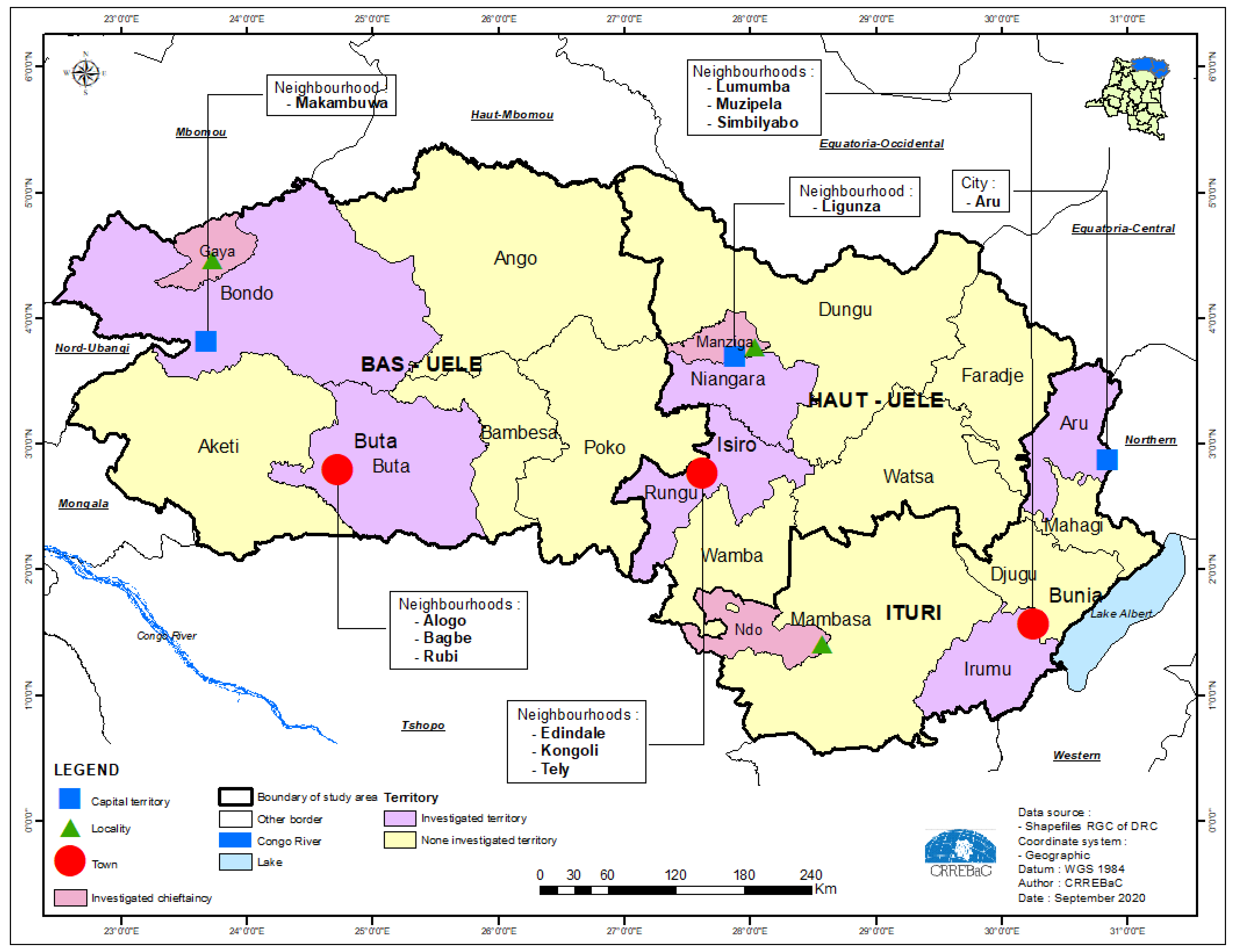
2. Study Region
3. Methodological Approach
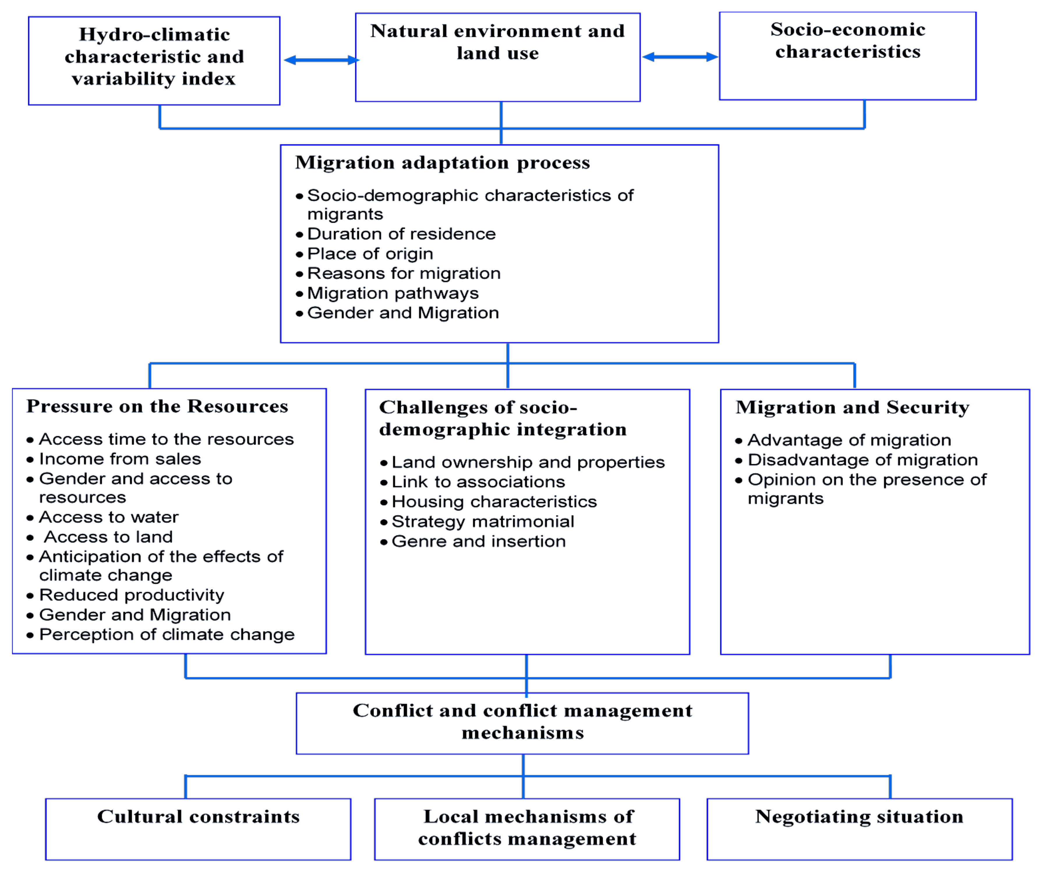
3.1. Conceptual Framework
3.2. Desing of Data Collection Tools
- Investigator’s guide;
- Household count sheet;
- Model sheet for sample selection;
- Sample draw sheet;
- Migrant routes sheet;
- A guide to focus-groups and group discussions;
- A guide to semi-direct interviews;
- A survey guide for management of protected areas;
- Household survey questionnaire.
3.3. Field Survey and Sampling
- The first level of comparison relates to the three different provinces in the northeastern part of the DRC;
- The second level of comparison involves urban, peri-urban and rural (cluster) environments in each of three provinces;
- The third level of comparison concerns migration status;
- The fourth level of comparison is gender-related.
- Visiting the cluster and numbering all households counted, using a count sheet, 1 to N (number of households);
- Computing “R” for random sample, R = N/30 and we rounded to double digits after the comma;
- Selecting a random number. To do this, a random number table at n digits (n being the number of values that constitute the entire part of R) is considered. The random number (T1 drawn indicates the ID number, sample number) in the survey base is the first sample unit (first household);
- Selecting the other sample units on the basis of the “R” draw step by creating an arithmetic progression based on T1 and for R = N/30;
- Setting survey numbers. This involves assigning a sequential number of 1 to n to all units held in the household;
- Identifying units of the sample: for each unit we searched for the identifiers of the actors.
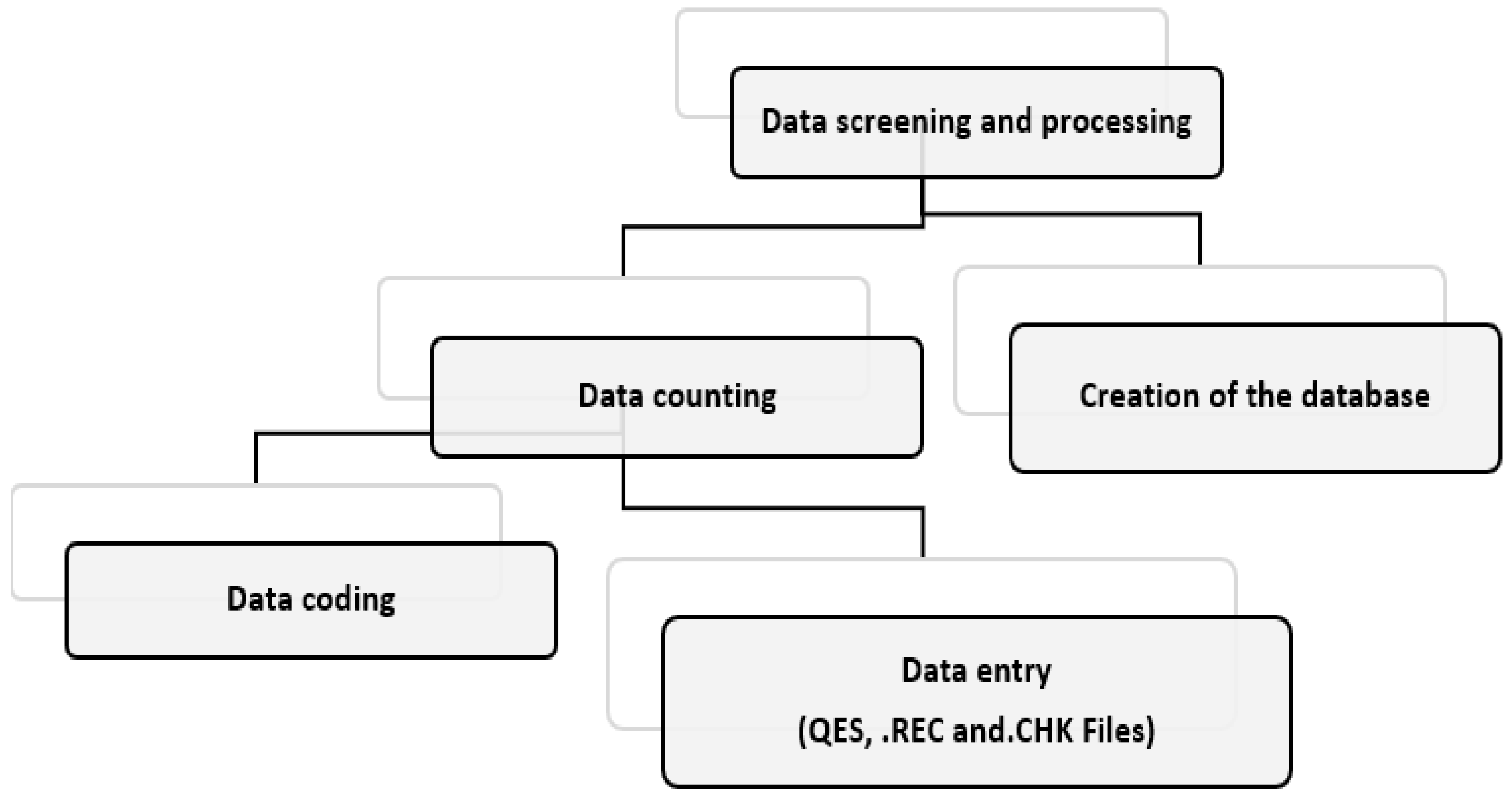
3.4. Data Screening and Processing
3.4.1. Data Coding
3.4.2. Data Entry
- Limiting the input of numbers to a given range or to a number of predefined values;
- Make the entry of a variable mandatory;
- Copy the contents of a variable from the previous record into the new record to be entered;
- Create transition to other variables based on the content of the data entered;
- Facilitate computation of variables based on the value of other variables;
- Facilitate computation of complexes operations.
3.4.3. Building the Database
3.4.4. Transformation of the Database from SPSS into an Interactive Data Visualisation Interface
4. Database Architecture and Information System on Climate-Water-Migrations-Conflicts (CEMiC)
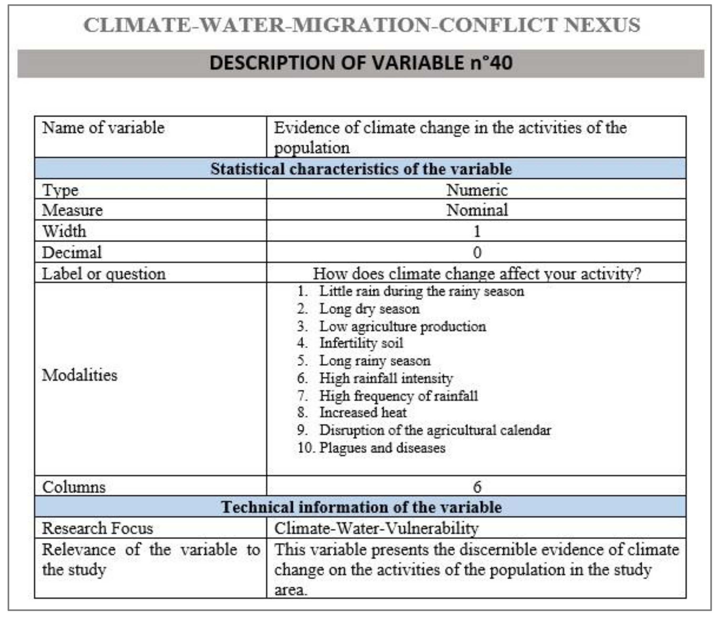
4.1. Data Types, Variables and Thematic Areas
- Migration statistics;
- Vital statistics in relation to the different segments of the populations constituting each “local community”;
- The actors, stakes and capacities of influence (powers: formal, informal and spiritual) upon each other;
- Strategies (mobilized social intelligence);
- The norms involved (cultural factors, customs and traditions, state laws, social practices put in place by actors, etc.);
- Statistics of human groups, livestock and land tenure;
- Local evidence of climate variability (images, units of measurements, local concepts, actors, durations of climatic seasons, flood levels, and regularity or irregularity of precipitation) and the links between climatic factors-migratory pressures-the availability or unavailability of water resources, the nature and types of violence and conflicts associated with them, and the mechanisms of resilience of communities;
- The perception of population, involving men, women and children on migrants and climate change;
- The experience of migrants themselves in transhumance, migration routes, cultural and natural realities encountered in transit and reception places;
- Differences constructed in the socio-cultural context of the Congolese, particularly in the provinces under study, including how conceptions and forms of masculinity/femininity facilitate or hinder gender equity in various areas of the country’s development;
- Shared views, different points of view.
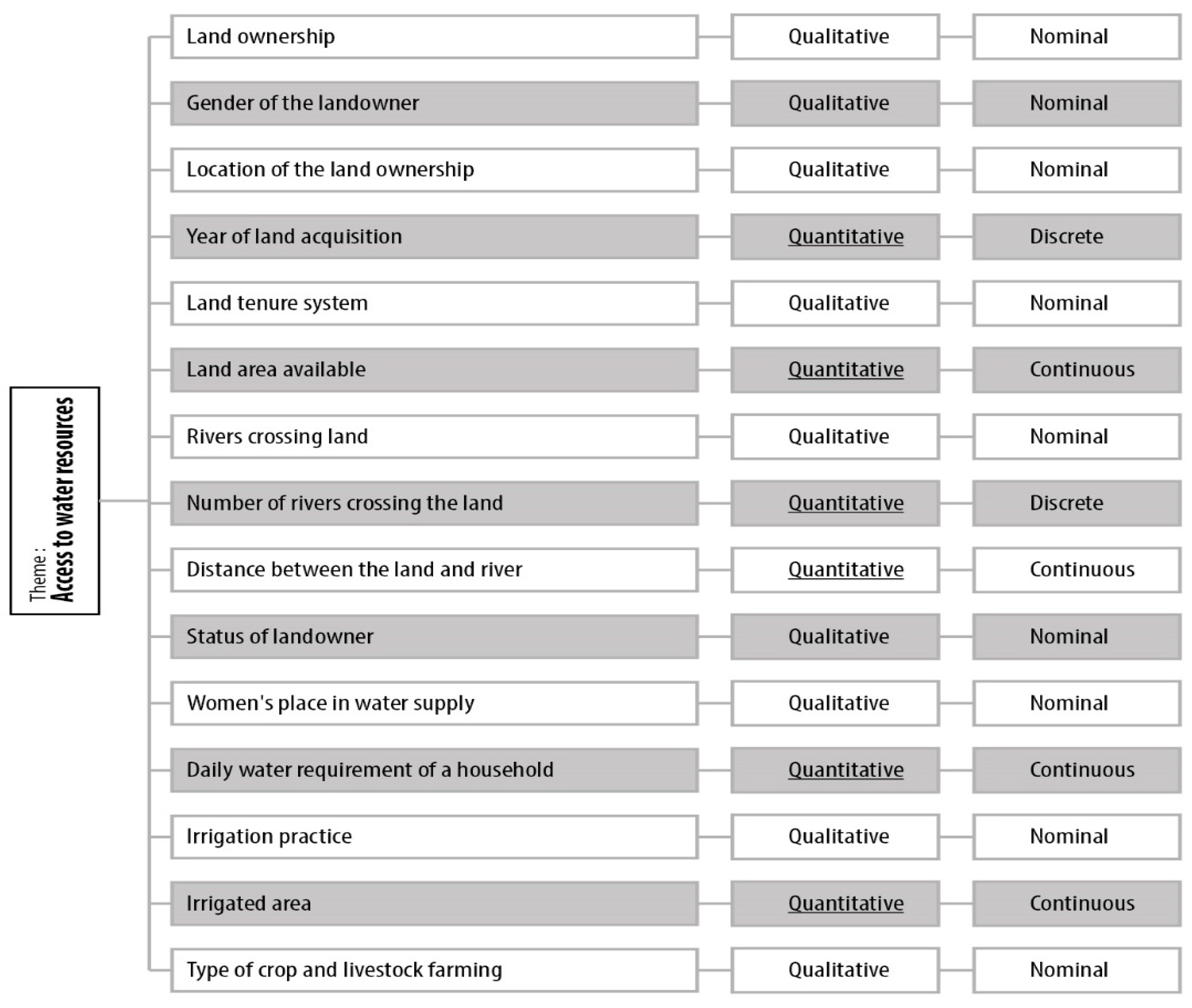
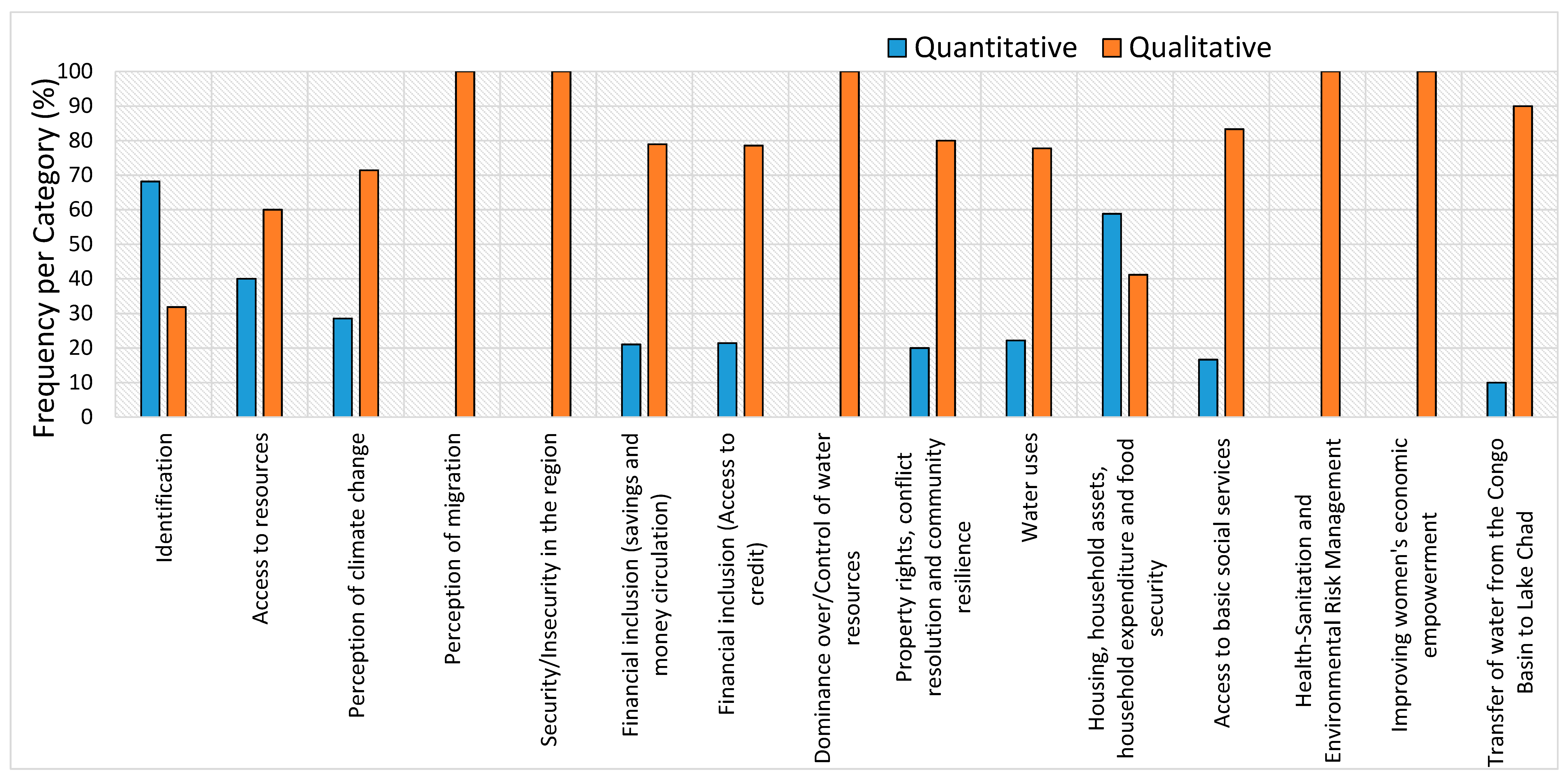
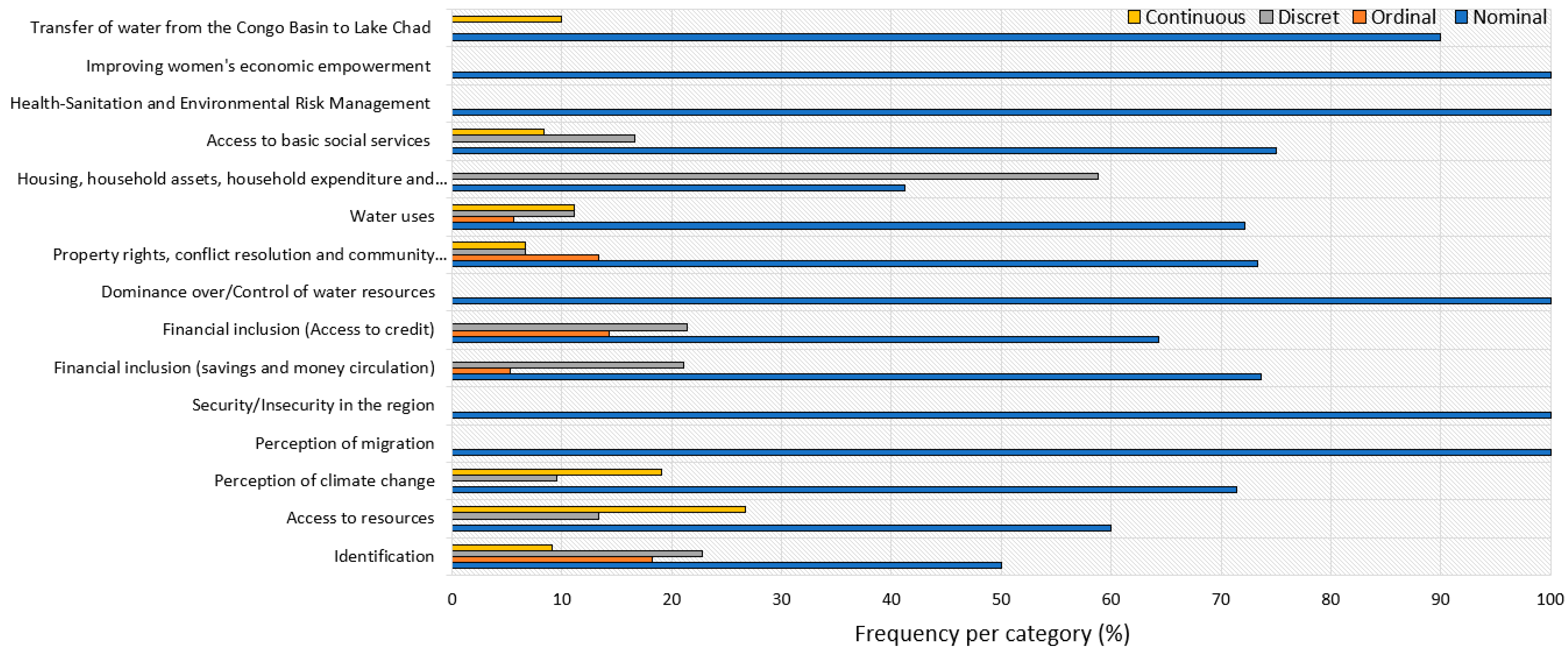
- Two criteria are used for the classification of the data types, including aggregation and the scale of measurement. Aggregation of variables consisted of compiling information contained in the database with the aim to constitute ensembles of data for data analysis [23]. The individual variables, also called disaggregated variables, contain the statistical characteristics of these ensembles. From a scale of measurement point of view, the variables are either qualitative or quantitative. Therefore, the disaggregated variables refer to the statistical nature of the variables which are quantitative or qualitative; nominal, ordinal, discrete or continuous.
4.2. Open Access Integrated Information System and Functionalities
- An online spreadsheet (Google Sheet) that allows data storage and correction of possible encoding during processing.
- An online tool for converting data into customizable informative reports and tables (Data Studio), which is used to produce the tables, graphs and filtering tools.
- A content Management System (Wordpress), known as one of the most effective tools for search engine optimization. It is used for the design and dynamic updating of websites or multimedia applications. A website dedicated to the presentation of data has been set up with the Wordpress tool connected to Data Studio.
- Home page: The home page is the link between the information system and visitors or users. Its purpose is to provide visitors or users with intuitive navigation of the platform’s data. It therefore has two essential functions, namely to clearly present and enhance the platform through various data updates and to direct the flow of visitors. It displays the list of themes in a structured way.
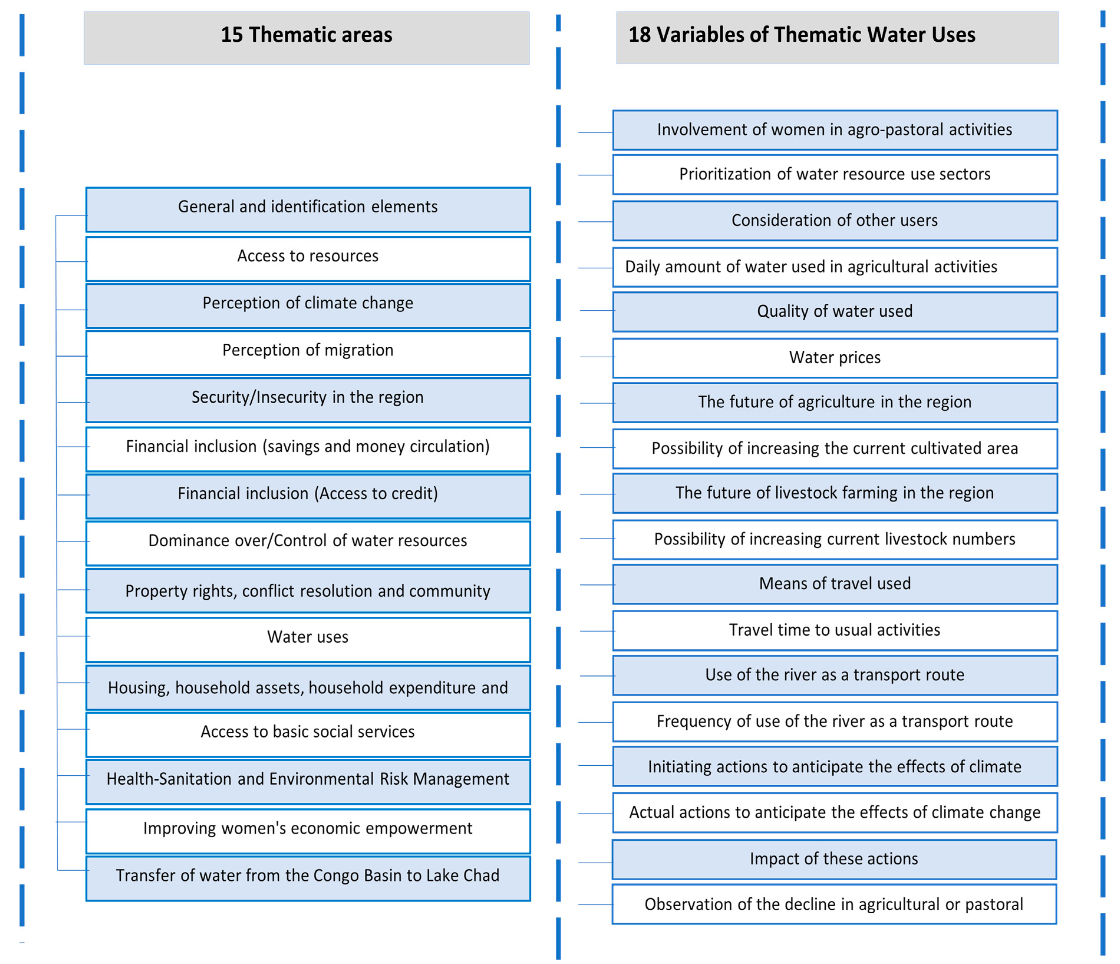
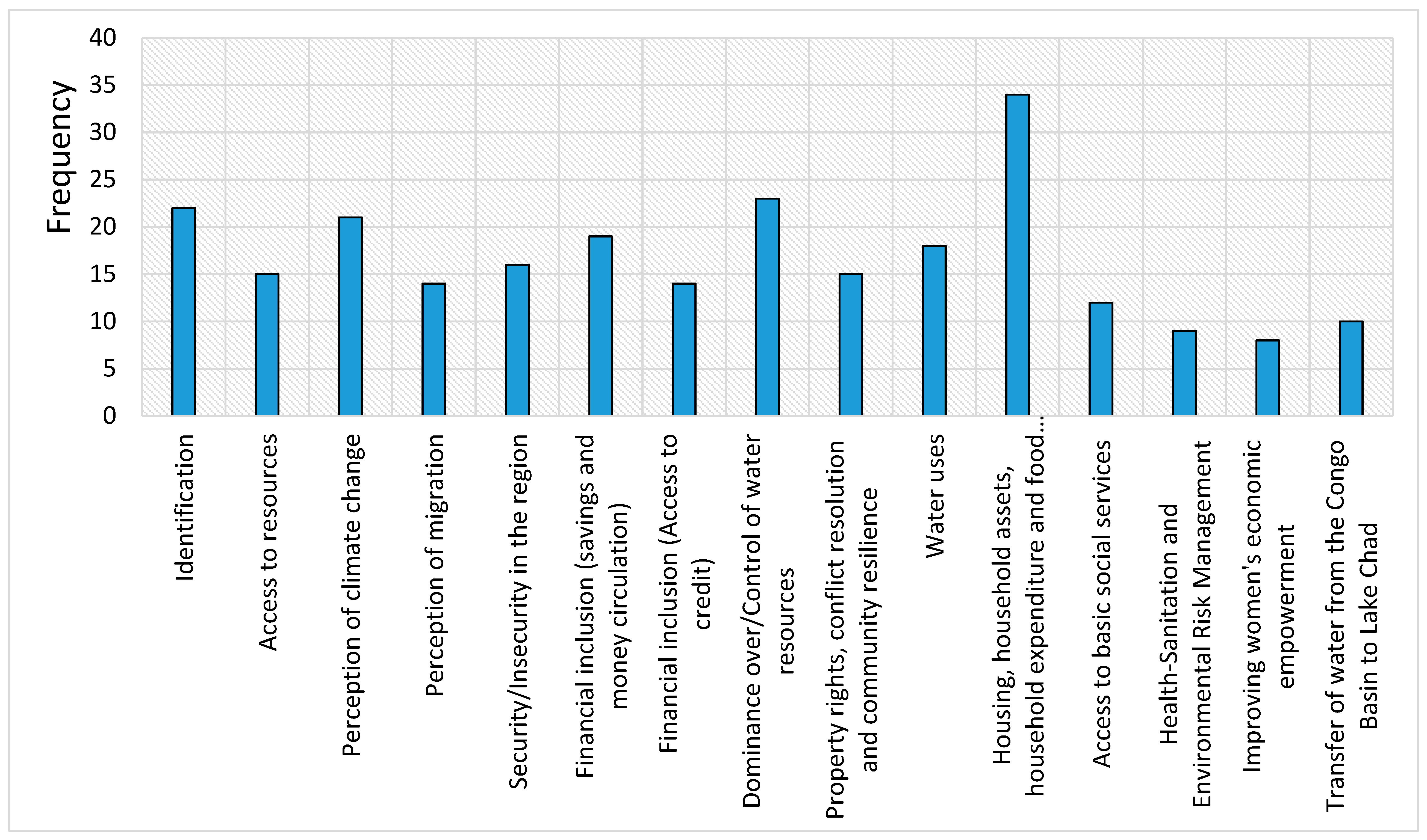
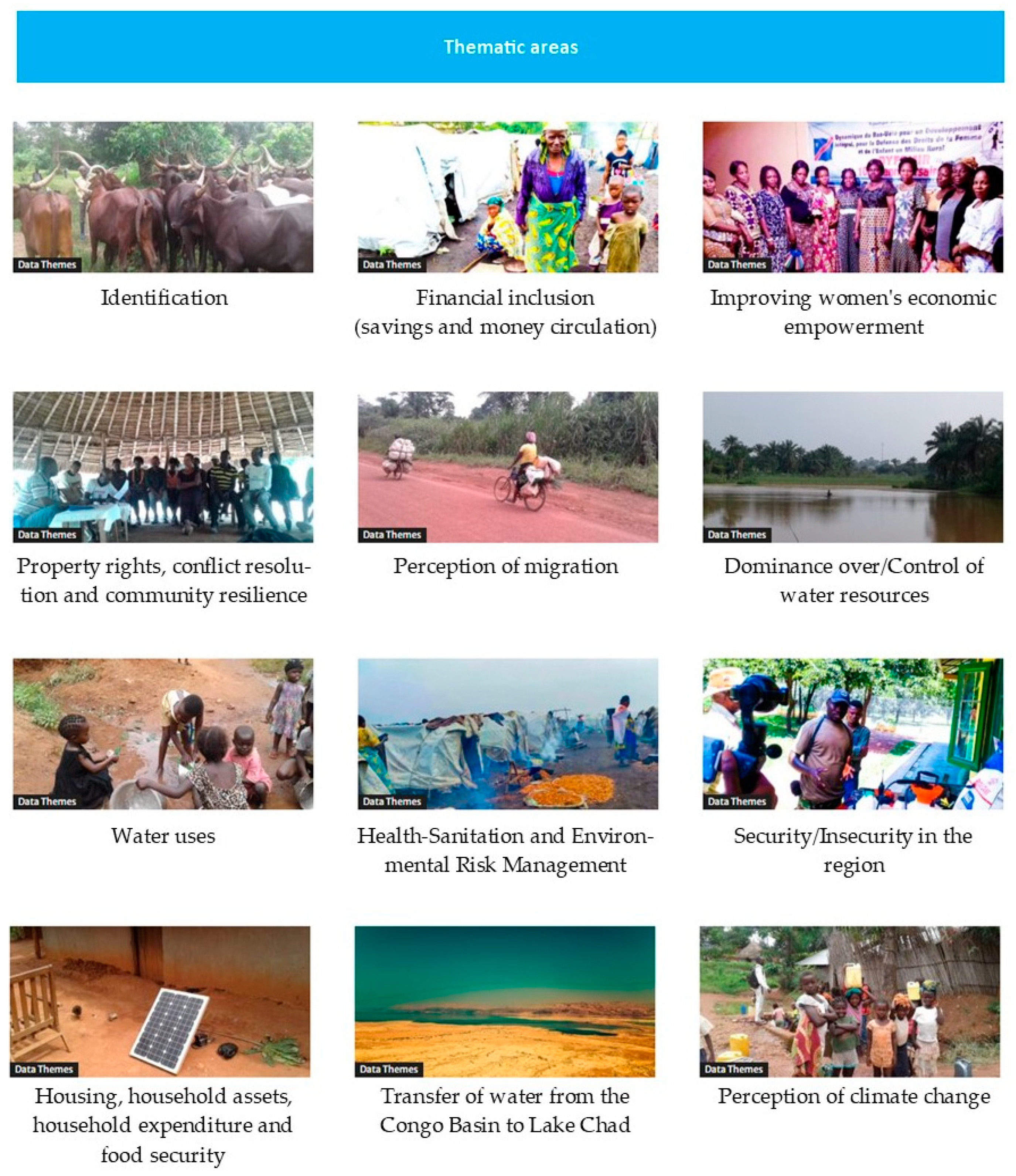
- Display of themes: The themes are organized in the second place, and each contains a list of variables. Each theme is described in a summarised way to allow visitors or users to get a feel for the content. Fifteen themes have been structured in this platform, each containing variables.
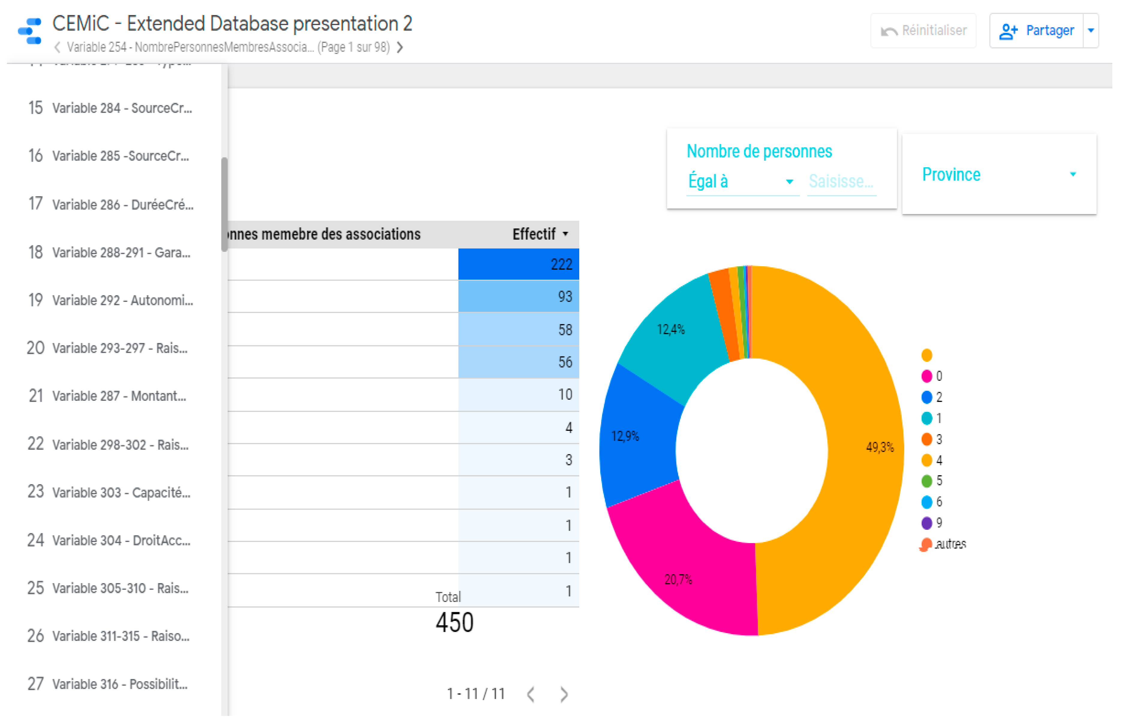
- Display of variables: The variable is the last unit of presentation in the information system and is presented in two ways, namely tabular and graphical. In the presentation of the variable, two navigation possibilities are made available to the user, namely navigation by province and navigation by locality. Two key pieces of information are also highlighted for each variable, namely the response modalities and the numbers (for the table) or percentages (for the graph). For every variable, a table and a graphic can be displayed, and the filter tools are used to facilitate navigation based on the three administrative boundaries, the territories or localities (Figure 12). The user will also find two filters next to the variable for downloading data in CSV format and for redirecting to appendix data (focus group and semi-structured interview transcript sheets) to the variable in word or pdf format.
5. Conclusions and Way Forwards
- Provide practical knowledge for decision makers and other stakeholders, along with enhanced understanding of the vulnerabilities, exposures and risks as well as participatory design of long-term investment and development strategies;
- Strengthen collaboration and experience sharing in the Congo Basin through interactions between researchers, policy makers, communities and other stakeholders;
- Contribute to the capacity building of stakeholders on emerging issues addressed by climate-water-migration-conflict nexus in the Congo Basin;
- Support policy and decision makers in the formulation and implementation of smart solutions to the impacts of climate change and the water crisis in the Congo Basin, with particular attention to the impacts of migration and conflict;
- Support key policy areas and strategies to foster effective stakeholder participation to ensure the management and governance of climate and natural resources, and gender consideration in all aspects, both at national, basin and regional levels;
- Strengthen political commitment to support climate resilient development in the Congo Basin;
- Support of the implementation of Sustainable Development Goals (SGDs), and help strengthen the capacity of local communities, empower women and benefit youth through insights for income and livelihood diversification activities.
Author Contributions
Funding
Institutional Review Board Statement
Informed Consent Statement
Data Availability Statement
Acknowledgments
Conflicts of Interest
References
- Trigg, M.A.; Tshimanga, R.M. Capacity Building in the Congo Basin: Rich Resources Requiring Sustainable Development. One Earth 2020, 2, 207–210. [Google Scholar] [CrossRef]
- Tshimanga, R.; Alsdorf, D.; Laraque, A.; Hughes, D.; Gulemvuga, G.; Mahe, G. Hydrology of Large Rivers: The Congo River Basin. In Handbook of Applied Hydrology; Singh, V., Ed.; McGraw-Hill Education: New York, NY, USA, 2016; ISBN 9780071835091. [Google Scholar]
- Tshimanga, R.M.; Hughes, D. Climate change and impacts on the hydrology of the Congo Basin: The case of the northern sub-basins of the Oubangui and Sangha Rivers. Phys. Chem. Earth 2012, 50–52, 72–83. [Google Scholar] [CrossRef]
- Molua, E.L. Reappraisal of the Climate Change Challenge in the Congo Basin and Implications for the Cost of Adaptation. Environ. Nat. Resour. Res. 2015, 5, 80. [Google Scholar] [CrossRef] [Green Version]
- OCHA (Office for the Coordination of Humanitarian Affairs). RD Congo: Plan de Remponse Humanitaire en Chiffres. 2020. Available online: https://www.unocha.org/drc (accessed on 1 April 2021).
- Kabamba, M. Les Migrants Climatiques En Quête D’adaptation: Les Éleveurs Mbororo Émmigrent en RD Congo. In Inégalité et Changement Climatique, Perspectives du Sud; Delgado-Ramos, G.C., Ed.; CODESRIA: Dakar, Sénégal, 2015. [Google Scholar]
- Magrin, G. The disappearance of Lake Chad: History of a Mythe. J. Political Ecol. 2016, 23, 204–222. [Google Scholar] [CrossRef] [Green Version]
- Lemoalle, J. Les Différents États du Lac Tchad, un Perpétuel Changement. In Atlas du lac Tchad; Magrin, G., Lemoalle, J., Pourtier, R., Eds.; Passages, Numero Spécial 183; IRD: Montpellier, France, 2015; pp. 23–27. [Google Scholar]
- UNEP. Water Issues in the Democratic Republic of the Congo: Challenges and Opportunities; United Nations Environment Programme: Nairobi, Kenya, 2011; Available online: https://wedocs.unep.org/20.500.11822/22067 (accessed on 1 April 2021).
- Africaine Union. Report on the Migrations of Mbororo Nomadic Pastoralists by the Fact-Finding Mission Dispatched to the Democratic Republic of Congo, the Central African Republic and Cameroon, Pursuant to Decision PSC/PR/COMM (XCVII). In Proceedings of the 97th Meeting of the Peace and Security, Addis Ababa, Ethiopia, 25 October 2007. [Google Scholar]
- Sayan, R.C.; Nagabhatla, N.; Ekwuribe, M. Soft power, discourse coalitions, and the proposed interbasin. Water Altern. 2020, 13, 752–778. [Google Scholar]
- Mutinga, M. La Guerre de l’eau aux Portes de la RDC. In Le Fleuve Congo et ses Affluents: Un Château d’eau Convoité; Le Potentiel: Kinshasa, Congo, 2014. [Google Scholar]
- Tshimanga, R.M.; Trigg, M.A.; Neal, J.; Ndomba, P.; Hughes, D.A.; Carr, A.B.; Kabuya, P.M.; Bola, G.B.; Mushi, C.A.; Beya, J.T.; et al. New Measurements of Water Dynamics and Sediment Transport Along the Middle Reach of the Congo River and the Kasai Tributary. In Congo Basin Hydrology, Climate, and Biogeochemistry: A Foundation for the Future, 1st ed.; Geophysical Monograph 269; John Wiley & Sons, Inc.: Washington, DC, USA, 2021; ISBN 9781119656975. [Google Scholar]
- Tshimanga, R.; Bola, G.; Kabuya, P.; Nkaba, L.; Neal, J.; Hawker, L.; Trigg, A.M.; Bates, P.; Hughes, A.; Laraque, A.; et al. Towards a Framework of Catchment Classification for Hydrologic Predictions and Water Resources Management in the Ungauged Basin of the Congo River: An a Priori Approach. In Congo Basin Hydrology, Climate, and Biogeochemistry: A Foundation for the Future, 1st ed.; Geophysical Monograph 269; John Wiley & Sons, Inc.: Washington, DC, USA, 2021; ISBN 9781119656975. [Google Scholar]
- Omasombo, T. Haut-Uélé: Trésor Touristique. In Monographies des Provinces de la République Démocratique du Congo; Le Cri-MRAC: Bruxelles-Tervuren, Belgium, 2011; Volume 2, p. 440. [Google Scholar]
- Omasombo, T. Bas-Uélé. In Pouvoirs Locaux et Économie Agricole: Héritages d’un Passé Brouillé; Le Cri-MRAC: Bruxelles-Tervuren, Belgium, 2014. [Google Scholar]
- Kiari, F.H. Impacts des Variations du Niveau du lac Tchad sur Les Activités Socio-Économiques des Pêcheurs de la Partie Nigérienne. Ph.D. Thesis, Université Abdou Moumouni de Niamey, Niamey, Niger, 2014. [Google Scholar]
- Réounodji, F. Conséquences de la Sécheresse sur les Activités Humaines: Les Exemples de Karal et de Guitté au sud du lac Tchad. Rev. Sci. Tchad. 1995, IV, 59–69. [Google Scholar]
- Magrin, G. Crise climatique et mutations de l’agriculture: L’émergence d’un grenier céréalier entre Tchad et Chari. Ann. Geogr. 1996, 592, 620–644. [Google Scholar] [CrossRef]
- Sarch, M.T.; Birkett, C. Fishing and farming at Lake Chad: Responses to lake-level fluctuations. Geogr. J. 2000, 166, 156–172. [Google Scholar] [CrossRef]
- Lemoalle, J.; Bader, J.-C.; Leblanc, M.; Sedick, A. Recent changes in Lake Chad: Observations, simulations and management options (1973–2011). Glob. Planet. Chang. 2012, 80–81, 247–254. [Google Scholar] [CrossRef]
- Lauritsen, J.M.; Bruus, M. A Comprehensive Tool for Validated Entry and Documentation of Data, EpiData Entry (Version) ed.; The EpiData Association: Odense, Denmark, 2003. [Google Scholar]
- Christiansen, T.; Lauritsen, J. EpiData—Comprehensive Data Management and Basic Statistical Analysis System; EpiData Association: Odense, Denmark, 2010. [Google Scholar]
- Pierce, D.; Ackerman, L. Data Aggregators: A Study of Data Quality and Responsiveness. Available online: https://Privacyactivism.org (accessed on 1 April 2021).
- Hiwasaki, L. Promoting linkages between Water and Culture: An Initiative of the Unesco-IHP. In Proceedings of the 10th International River Symposium and Environmental Flows Conference, Brisbane, QLD, Australia, 3–6 September 2007. [Google Scholar]
- Gebru, B.; Mworozi, E. L’amélioration de L’accès à L’information Climatique Permet de Réduire Les Pertes et Les Dommages Causés aux Récoltes en Ouganda. In Programme Changements Climatiques et Eau du Centre de Recherches Pour le Développement International; WRENmedia: Eye, UK, 2015. [Google Scholar]
- Firmian, I.; Mwanundu, S. Développement Agricole Résilient au Changement Climatique: Note sur La Transposition à Plus Grande Échelle; FIDA: Rome, Italy, 2016; p. 12. [Google Scholar]
- FIDA. Programme D’Adaptation de L’Agriculture Paysanne–ASAP; FIDA: Rome, Italy, 2012. [Google Scholar]
- FAO. L’action de la FAO Face au Changement Climatique. In Proceedings of the Conférence des Nations Unies sur Les Changements Climatiques, Katowice, Poland, 2–15 December 2018. [Google Scholar]
- FAO. Renforcer la Résilience aux Changements Climatiques: La Voie à Suivre Pour Répondre aux Effets des Évènements Climatiques Extrêmes sur L’agriculture. In Proceedings of the Conférence des Nations Unies sur les Changements Climatiques, Rome, Italy, 4–8 November 2019. [Google Scholar]
- Elela, D.N. Les migrations transfrontalières des Mbororo au Nord-Est de la RDC. In Etude de Cas au Haut-Uélé et au Bas-Uélé; IKV Pax Christi: Brussels, Belgium, 2007. [Google Scholar]
- Search for Common Ground. Implantation des Mbororo et Analyse de Conflit Dans la Zone Haut et Bas-Uélé de la Province Orientale en RDC; Search for Common Ground: Province Orientale, Congo, 2014; Available online: https://docplayer.fr/32722987-Zone-haut-et-bas-uele.html (accessed on 1 April 2021).
- CRREBaC. Climate-Water-Migration-Conflict Nexus in the Congo Basin: Analysing Interactions to Build Community Resilience; 2021; in press. [Google Scholar]
- GIEC. Bilan 2007 des Changements Climatiques. In Contribution des Groupes de Travail I, II et III au Quatrième Rapport D’Évaluation du Groupe D’Experts Intergouvernemental sur L’Évolution du Climat; GIEC: Geneva, Switzerland, 2007; p. 103. [Google Scholar]
- GIZ. Guide de Référence sur la Vulnérabilité: Concept et Lignes Directrices Pour la Conduite D’analyses de Vulnérabilité Standardisées. In Risk Supplement: How to Apply the Approach with the IPCC AR5 Risk Concept; GIZ: Bonn, Germany, 2017; p. 180. [Google Scholar]
- FAO. Stratégie de la FAO Relative au Changement Climatique; FAO: Rome, Italy, 2017; pp. 11–52. [Google Scholar]
- CEDEAO. Un Cadre Juridique Adapté et Harmonisé Pour Une Transhumance Transfrontalière Durable Dans L’Espace CEDEAO, Note Pour Décideurs. 2015. Available online: http://www.fao.org/documents/card/fr/c/cc2d3231-b894-434c-8e37-fad053c829ea/ (accessed on 1 April 2021).
- CEDEAO. Rencontre Régionale de Haut Niveau Pour Une Transhumance Transfrontalière Apaisée et Pour L’Adoption des Modalités Financières du Programme D’Investissement Pour le Développement de L’Élevage et du Pastoralisme en Afrique de l’Ouest, Rapport de la Réunion des Experts. 2017. Available online: https://unsdg.un.org/sites/default/files/cf-documents/ef1238c0-d18e-48ea-8897-c4ed398e1523_Mauritania_CPDD_2018-2022_sign%C3%A9.pdf (accessed on 1 April 2021).
- De Wasseige, C.; de Marcken, P.; Hiol-Hiol, F.; Mayaux, P.; Desclee, B.; Nasi, R.; Billand, A.; Defourny, P.; Eba’a Atyi, R. Les Forêts du Bassin du Congo–État des Forêts 2010. 2012. Available online: https://ecdpm.org/events/rencontre-regionale-de-haut-niveau-pour-une-transhumance-transfrontaliere/ (accessed on 1 April 2021).
- Bourgeois, R.; Brunelle, T.; Losch, B.; Prati, G. Le Changement Climatique: Un Facteur Complexe de la Migration Rurale. In Une Afrique Rurale en Mouvement: Dynamiques et Facteurs des Migrations au Sud du Sahara; CIRAD: Montpellier, France, 2018; pp. 44–47. [Google Scholar]
- CEDEAO. Aménagements Pastoraux et Organisation de la Transhumance Transfrontalière, Note Technique du Programme. 2009. Available online: https://www.oecd.org/fr/csao/publications/Volume2_Annexe_Transhumance_Final1.pdf (accessed on 1 April 2021).
- Gautier, D.; Corniaux, C.; Alary, V. De la Côte à la Côte: Itinéraire du Bétail des Territoires Naisseurs Maliens aux Métropoles Régionales Côtières et Proactivité des Stratégies D’acteurs le Long de Cette Chaine; CIRAD: Montpellier, France, 2009; p. 13. [Google Scholar]
- Duteurtre, G.; Koussou, M.-O.; Essang, T.; Kadekoy-Tiguague, D. Le Commerce de Bétail Dans les Savanes d’Afrique Centrale: Réalités et Perspectives; CIRAD: Montpellier, France, 2015; p. 8. [Google Scholar]
- Nagabhatla, N.; Fioret, C. The Water-Migration Nexus: An Analysis of Causalities and Response Mechanisms with a Focus on the Global South. In Regional Integration and Migration Governance in the Global South; Rayp, G., Ruyssen, I., Marchand, K., Eds.; Springer: Cham, Switzerland, 2020; Volume 20. [Google Scholar]
- Dudley, N. Lignes Directrices Pour l’Application des Catégories de Gestion aux Aires Protégées; UICN: Gland, Switzerland, 2008; p. 96. [Google Scholar]
- Crawford, A.; Brown, O. Climate Change and Security in Africa; International Institute for Sustainable Development: Winnipeg, MO, Canada, 2009. [Google Scholar]
- FSIN. Rapport Mondial Sur les Crises Alimentaires 2017: Résumé Exécutif; Food Security Information Network. 2017. Available online: http://www.fao.org/resilience/resources/ressources-detail/fr/c/877609/ (accessed on 1 April 2021).
- Burkhard, B.; Müller, F. Driving, Pressure, Impact, State Response; Elsevier: Amsterdam, The Netherlands, 2007. [Google Scholar]
- LeDanff, J.-P. La Convention sur la Diversité Biologique: Tentative de Bilan Depuis le Sommet de Rio de Janeiro. VertigO la Revue Électronique en Sciences de L’Environnement 2002, 3. [Google Scholar] [CrossRef]
- ICCN. Stratégie Nationale de Conservation de la Biodiversité Dans les Aires Protégées en République Démocratique du Congo; ICCN: Valencia, Spain, 2012; p. 18. [Google Scholar]
- Billand, A. Biodiversité Dans les Forêts d’Afrique Centrale: Panorama des Connaissances, Principaux Enjeux et Mesures de Conservation in Etat des Forêts du Bassin du Congo; CIRAD: Montpellier, France, 2012; p. 32. [Google Scholar]
- IPBES. Évaluation Mondiale de la Biodiversité et des Services Écosystémiques, Rapport sur les Principaux Messages de l’Évaluation IPBES aux Décideurs, Agence Française Pour la Biodiversité (AFB); IPBES: Bonn, Germany, 2012. [Google Scholar]
- PNUD. Rapport Sur Le Développement Humain 2019 Portant Sur Les Inégalités De Développement Humain Au Xxie Siècle. 2019. Available online: https://www.fondationbiodiversite.fr/wp-content/uploads/2019/11/IPBES-Depliant-Rapport-2019.pdf (accessed on 1 April 2021).
- Réseau National des Femmes Rurales du Sénégal. Atelier International Femmes Rurales et Foncier. In Proceedings of the Projet FAO-Dimitra et d’ENDA PRONAT Centre Forestier de Recyclage, Thiès, Sénégal, 25–27 February 2003. [Google Scholar]
- ONU-Femme. Rapport Annuel 2015–2016; ONU-Femme: New York, NY, USA, 2021. [Google Scholar]
- des Peuples, D. La Première Guerre de L’eau Aura-t-elle Lieu en Afrique Centrale? Available online: https://www.cairn.info/revue-herodote-2003-4-page-11.htm (accessed on 1 April 2021).


| Province | Cluster | Cluster Name | Number Household | Sample Size | No Poll | Focus Group | Discussion Group | Individual Interview | Route Sheet |
|---|---|---|---|---|---|---|---|---|---|
| Bas Uélé | Urban (City of Buta) | Ruby | 320 | 30 | 10 | 2 | 1 | 5 | 3 |
| Bagbe | 320 | 30 | 10 | 2 | 1 | 5 | 3 | ||
| Alongo | 320 | 30 | 10 | 2 | 1 | 9 | 6 | ||
| Peri-urban (City of Bondo) | Makambuwa | 320 | 30 | 10 | 2 | 1 | 6 | 4 | |
| Rural (Gaya Chefferie) | Localité Baye | 320 | 30 | 10 | 3 | 2 | 7 | 3 | |
| Top Uélé | Urban (City Isiro) | Tely | 328 | 30 | 10 | 3 | 2 | 3 | 2 |
| Kongoli | 324 | 30 | 10 | 3 | 1 | 3 | 2 | ||
| Edindale | 322 | 30 | 10 | 3 | 1 | 6 | 1 | ||
| Peri-urban (City of Niangara) | Ligunza | 300 | 30 | 10 | 3 | 1 | 4 | 3 | |
| Rural (Chefferie Manziga) | Nambia | 300 | 30 | 10 | 3 | 1 | 2 | 12 | |
| Ituri | Urban (City of Bunia) | Simbilyabo | 360 | 30 | 12 | 2 | 1 | 5 | 5 |
| Muzipela | 360 | 30 | 12 | 1 | 1 | 5 | 5 | ||
| Lumumba | 360 | 30 | 12 | 1 | 1 | 5 | 5 | ||
| Peri-urban (City ofAru) | City ofAru | 300 | 30 | 10 | 2 | 1 | 3 | 4 | |
| Rural (NdoSector) | Epulu location | 300 | 30 | 10 | 2 | 1 | 6 | 4 |
Publisher’s Note: MDPI stays neutral with regard to jurisdictional claims in published maps and institutional affiliations. |
© 2021 by the authors. Licensee MDPI, Basel, Switzerland. This article is an open access article distributed under the terms and conditions of the Creative Commons Attribution (CC BY) license (https://creativecommons.org/licenses/by/4.0/).
Share and Cite
Tshimanga, R.M.; Lutonadio, G.-S.K.; Kabujenda, N.K.; Sondi, C.M.; Mihaha, E.-T.N.; Ngandu, J.-F.K.; Nkaba, L.N.; Sankiana, G.M.; Beya, J.T.; Kombayi, A.M.; et al. An Integrated Information System of Climate-Water-Migrations-Conflicts Nexus in the Congo Basin. Sustainability 2021, 13, 9323. https://doi.org/10.3390/su13169323
Tshimanga RM, Lutonadio G-SK, Kabujenda NK, Sondi CM, Mihaha E-TN, Ngandu J-FK, Nkaba LN, Sankiana GM, Beya JT, Kombayi AM, et al. An Integrated Information System of Climate-Water-Migrations-Conflicts Nexus in the Congo Basin. Sustainability. 2021; 13(16):9323. https://doi.org/10.3390/su13169323
Chicago/Turabian StyleTshimanga, Raphael M., Génie-Spirou K. Lutonadio, Nana K. Kabujenda, Christian M. Sondi, Emmanuel-Tsadok N. Mihaha, Jean-Felly K. Ngandu, Landry N. Nkaba, Gerard M. Sankiana, Jules T. Beya, Anaclet M. Kombayi, and et al. 2021. "An Integrated Information System of Climate-Water-Migrations-Conflicts Nexus in the Congo Basin" Sustainability 13, no. 16: 9323. https://doi.org/10.3390/su13169323