
Multiscale Integral Assessment of Habitability in the Case of El Raval in Barcelona


1
Architectural Technology Department, Universitat Politècnica de Catalunya—Barcelona Tech, 08028 Barcelona, Spain
2
Architectural Design Department, Universitat Politècnica de Catalunya—Barcelona Tech, 08028 Barcelona, Spain
*
Author to whom correspondence should be addressed.
Sustainability 2021, 13(9), 4598; https://doi.org/10.3390/su13094598
Submission received: 1 March 2021
/
Revised: 23 March 2021
/
Accepted: 26 March 2021
/
Published: 21 April 2021
(This article belongs to the Special Issue Sustainability Assessment of Architecture, Construction, Refurbishment and Restoration)
Abstract
:The understanding of habitability conditions of existing housing stock plays a central role in the quantification and qualification of sustainability from the architectural field. This research assessed habitability as a fundamental social benefit by means of a multiscale approach to the case study of the Raval neighborhood that can be replicated in other settings. We described a sample of six hundred dwellings located in two urban blocks spatially and typologically. This analysis of architectural features incorporated information on the current occupancy and use of spaces and the assessment of the state of conservation and maintenance of building envelopes and common elements. Although the scale of most analyzed aspects was larger (building, urban block or urban fabric), the discussion of results by housing unit provided a close picture of the existing diversity and heterogeneity of socio-spatial and architectural realities within buildings and urban blocks. Results from this paper allow for the valuation and discussion of substandard housing cases that call for an immediate improvement and adaptation, while providing evidence that most dwellings fail to fulfill residents’ right to adequate housing. In conclusion, the results obtained highlight the importance of designing rehabilitation programs and instruments to improve existing spaces with a focus on current use, occupancy, and residents’ needs.
1. Introduction
In recent years—particularly since the 2008 financial recession—the problem of housing in Europe has taken a significant turn for the worse. Social movements are increasingly vociferous about the right to adequate housing for all, and the housing problem has become one of the most pressing emergencies for local, regional and national administrations, as well as for international organizations that seek to guarantee human rights [1,2].
The lack of adequate housing is inseparable from other forms of inequality, and it often leads to residential exclusion and homelessness [3]. It is particularly extreme in southern Europe—especially in Spain and Portugal—due to the systemic scarcity of public housing [4]. In this respect, Catalonia is no exception; in fact, it is among the European regions where the housing problem is most alarming [5,6]. Due to the lack of adequate, affordable housing, the most underprivileged members of society are forced to live in spaces that fail to meet the minimum requirements for habitability [7,8,9].
In this context, we need empirical investigations that provide precise information on the scope of inadequate and substandard housing, particularly in underprivileged settings.
1.1. Theoretical and Regulatory Approaches for the Empirical Measurement of Habitability
Adequate housing is recognized by international law as essential to a decent standard of living [10]. It is one of the focuses of the UN’s 2030 Agenda, specifically Sustainable Development Goal 11: Sustainable Cities and Communities, and Target 11.1.: “By 2030, ensure access for all to adequate, safe and affordable housing and basic services and upgrade slums” [11,12]. When defining the idea of housing deprivation, the Sustainable Development Goals (SDGs) include the categories “informal settlements” and “inadequate housing” in addition to the more restrictive category “slum”, which is often also described as “substandard housing” in academic studies [13]. This wider perspective is designed to underline “the universality of the right to access to adequate, safe and affordable housing for all”, an issue that affects a large majority of individuals ranging from the severely vulnerable to those in the middle class [6,14,15,16,17].
The United Nations Committee on Economic, Social and Cultural Rights (ICESCR) defines seven elements—including habitability and affordability [18,19]—as keys to addressing the problem of inadequate housing. Habitability is defined as the “provision of conditions that are good enough to live in or on” [20], and, according to ICESCR, it consists of “providing the inhabitants with adequate space and protecting them from cold, damp, heat, rain, wind or other threats to health, structural hazards, and disease vectors” [18,19].
One of the requirements the 2030 Agenda places on states is the development of methods for studying housing conditions and monitoring the existing residential fabric, particularly in the most vulnerable settings [21,22]. Although to assess inadequate housing, SDG indicator 11.1.1 refers exclusively to affordable housing [21], the criteria for defining slums, informal settlements and inadequate housing are based primarily on habitability dimensions: access to water, access to sanitation, sufficient living area (overcrowding), structural quality, durability and accessibility, among others [11].
Along the same lines, some research studies treat habitability as one of the axes of inequality when analyzing urban and residential vulnerability [23,24,25,26,27,28,29,30,31]. These are largely studies of public-access statistical databases that include sparse and often outdated data on the state of conservation of the building stock [32,33,34,35,36]. Previous studies refer to the difficulty and limitations of using nothing but quantitative data taken from statistical databases, and they all agree that the insufficient disaggregation of existing databases tends to homogenize the complexity of the setting. These limitations are even more profound in contexts of high socio-residential vulnerability, where fieldwork is deemed especially necessary [37,38,39].
The obligation to generate databases to monitor compliance with the 2030 Objectives has led to the recent creation of public organizations capable of carrying out broad data studies on the characteristics of existing housing [40,41,42,43]. On a regional level, policies on urban regeneration are increasingly based on detailed data studies [44,45,46,47,48,49,50,51,52,53,54].
To supersede data limitations and better address the complex reality of urban settings, many academic studies have approached housing conditions through extensive fieldwork that provides qualitative and disaggregated data with an increasing focus on residents’ perspectives and satisfaction [55]. These generally consist of case studies focused on specific neighborhoods, public housing stock [56,57] or specific groups of residents [8,58,59]. The results these studies provide are much more contrasted and useful for describing the housing situation. However, they are hard to reproduce for massive numbers of housing units or for samples selected using technical or urban criteria, such as all the dwellings in a particular setting. The criteria for selecting interviewees—often based on their participation in social entities—can alter samples and results. Meanwhile, the decision to conduct invasive studies on a random sample or a complete urban setting can generate false expectations or prove bothersome to a population that is already in dire circumstances.
On a regional level, very few studies have addressed habitability using mixed methods combining the assessment of study cases with massive statistical analyses ranging from the study of large regions to individual cities or neighborhoods [60,61,62,63,64]. This field of study is expected to experience exponential growth in the coming years. However, studies of this type are in uncharted territory, so it is important to test the efficacy of their methods.
In summary, it has proven extremely difficult to analyze a large area using information specific to each dwelling due to the lack of trustworthy data, limited access, the partiality of the samples studied and difficulty verifying the information provided by residents.
Our first research question is whether the housing conditions in a large urban area can be analyzed through a non-invasive study. Is this analysis possible without entering homes or conducting a large-scale survey of residents? Can any of the gaps in the available statistical and cartographic information be filled through direct, on-the-ground observation?
We hope to answer this first question by testing an exploratory method on a case study: Barcelona’s Raval neighborhood, a setting with high socio-residential vulnerability located in the city center of Barcelona, in Catalonia, Spain.
In Spain, where housing standards are the responsibility of the regional government, there are no regulations that can define existing buildings as inadequate housing. However, substandard housing is defined as “a building, or part of a building, used as a residence that does not fulfill the minimum standards defined in applicable legislation” [65,66,67]. The only legal standards applicable to the existing residential fabric refer to certain morphological characteristics—primarily in the interior of residences—such as minimum usable dwelling area or the state of basic utilities, as well as maximum occupancy by room surface area. Briefly and somewhat ambiguously, they also refer to the state of repair of buildings, with requirements like “buildings must be solidly built, must avoid the penetration of humidity and rainwater, must prevent flooding of the residence, and must have walkable floors” [67].
The only unit of analysis included in existing regulations on residential buildings is the dwelling, except when referring to vertical accessibility within the building. The common spaces in buildings serve as a buffer between public spaces and private homes, and although they have often been described as conflictive, degraded spaces in underprivileged communities [68,69], they are also essential to promote interaction, mutual support, neighborliness, a sense of community and resident satisfaction [70,71,72].
Moreover, although the Catalan Law on the Right to Housing emphasizes the importance of focusing on the residents [66], its strict assessment of overcrowding places more of a focus on the inconveniences it may cause to third parties than its impact on residents [73]. Regulations on habitability and municipal ordinances also neglect residents’ perspectives and refer only to overcrowding.
Contemporary research emphasizes the importance of a more broadly resident-centered approach, meaning that we must consider how spaces interact with their inhabitants and how these inhabitants perceive the space [58]. When determining “what affordable housing should afford”, Vale et al. [74] use the term “affordance”, described initially by Gibson as “something that implies the complementarity of the animal and the environment” [75,76]. Salvador Rueda defines “quality of life” as “the quality of experience that the subject has of life”, and defines “appropriation” as a concept that describes “the relational, dynamic process between the subject and the urban and social reality, which will profoundly impact the level of satisfaction the subject has of this reality.” [77,78]. Appropriation is also presented as a key to the study of the affordances that a particular space permits in keeping with its qualities. [74,75,76,77,78].
In summary, current regulations affecting existing homes have an extremely partial view focused solely on the interior of dwellings; they fail to address the urban fabric these homes are a part of and only deal with morphological issues, neglecting the role and perspective of residents and the affordances of living spaces [79]. Furthermore, housing standards are focused on newly built dwellings, even though existing dwellings make up the immense majority of all available housing [80]. The current scope of these regulations contradicts the SDGs’ universalist view of the right to housing for all [14,15,16,17].
With this in mind, this study attempts to test a method of analyzing the housing conditions of the existing residential fabric in line with more contemporary approaches to the concept of habitability [62,79,80]. This method must go beyond the limits of existing regulations and purely morphological questions, taking into account the residents’ relationship with their environment, the scale of the building, its common spaces, and the urban fabric, while maintaining the dwelling as the unit of analysis.
1.2. Habitability in Barcelona’s Raval Neighborhood
The Raval was originally urbanized as an expansion of the old city, which was experiencing a sharp rise in population with the industrialization and proletarianization of Barcelona. As a result, this was the first neighborhood in the city built primarily to house modern workers. Like many European or Spanish historic centers, it suffered from a process of gradual abandonment until the 1980s [81,82], when multiple intervention programs were designed to regenerate Ciutat Vella in keeping with the so-called “Barcelona Model”. Urban regeneration was executed from 1994 to 1999, along with significant public and private investments in the rehabilitation of residential buildings [83]. Over the last few decades, the Raval has undergone transformations tied to the effects of urban regeneration, the growing pressure of tourism on historic city centers, and the arrival of the most recent wave of immigration to Spain’s cities in the 2000s [84,85,86].
Due to its importance as part of the historic center of Barcelona and the singularity of the socio-urban processes it has experienced, the Raval has been the subject of several studies in the fields of social sciences, architecture and urbanism. First, it is worth noting a series of studies from the 1980s and 1990s that were meant to guide future public programs for urban rehabilitation and regeneration [87,88,89,90,91,92,93]. These studies provide analyses of the characteristics of historic buildings, their shortcomings, possible means of improvement, the characteristics of residents and forms of ownership and use; some see certain types of buildings and dwellings as the focus of shortcomings in habitability [92,93].
In the period soon after the execution of the aforementioned public programs, there were several notable social science studies that focused on how these public interventions had affected residents, many of whom were seriously underprivileged [94,95,96,97,98,99,100,101]. Regarding habitability, some of these studies noted the abundance of hidden and scattered micro-inequalities [100,101].
Finally, some very recent studies have been carried out in order to guide new public programs for the rehabilitation of the residential fabric in the Raval and other vulnerable neighborhoods in Barcelona as part of the Program for the Rehabilitation of Complex Buildings, which is in turn part of the broader Neighborhood Plan [48,102]. This is a new decisive public rehabilitation effort that aims to help redistribute wealth [103]. These recent studies provide a detailed, updated look at certain dimensions of urban vulnerability in the city, including socio-urban and residential vulnerability, with some data disaggregated on the scale of the city block or individual building [49,50,104,105]. They also contribute to the pre-diagnosis of residential buildings, combining data analysis with fieldwork even though they are focused only on the state of repair of buildings.
The aforementioned studies all agree that the Raval is an extremely diverse setting. This is due to the vastly different processes different buildings and areas have undergone, the many forms of public and private investment that have sought to alter the neighborhood, and ongoing urban and socio-economic changes [106,107]. All these trends have led to changes and adaptations in the residential fabric that may have defied the predictions of the most profound analyses of housing from the 1990s [92,93].
The Raval is currently part of the Ciutat Vella district, Barcelona’s historic center. Despite a series of public rehabilitation and urban renewal programs organized over the last three decades [45,83], most areas in the neighborhood still suffer from extreme socio-residential vulnerability [49]. The Raval is one of the neighborhoods with the lowest per capita income in the city, where the cost of housing of a mostly private rental stock takes up an extremely large portion of household income [36,108]. It is made up primarily of 19th-century buildings, many of which are in poor condition [43,49,50,104]. Dwellings in the Raval have very small dwelling areas, and some parts of the neighborhood are among the most densely populated in the city [26,49,54]. The mortality rate due to respiratory diseases in the Raval is extremely high, just like in other areas of Barcelona with a high level of socio-residential vulnerability [49].
For all these reasons, the Raval is an ideal study case for the analysis of housing conditions.
Our second research question is how prevalent is substandard housing in the area studied? Are cases of substandard housing scattered randomly across the neighborhood, or can they be tied to certain types of buildings?
However, this paper hopes to go beyond the problem of substandard housing and address habitability conditions from a broader perspective. To this end, our final study question is: to what degree is the housing inadequate, and what aspects of habitability affect this the most?
1.3. Objectives:
The primary objectives of this research were as follows:
- To test an integral and multi-scalar method for analyzing the habitability of a large residential area in a historic center with serious inequalities when the interior of dwellings cannot be accessed.
- To broaden knowledge of housing conditions in the area of study by combining morphological information, socio-spatial information, and information on the state of repair.
- To determine whether certain types of buildings and dwellings—and their transformation over time—are tied to current habitability conditions.
This study provides information on whether non-invasive methods (where the investigators do not enter homes or speak with residents) can accurately address large areas of residential fabric. It proposes a method midway between the massive analysis of statistical data and qualitative case studies. Furthermore, it suggests ways of making up for the shortcomings of this method. The results obtained broaden our understanding of the diverse housing conditions found within the neighborhood, city blocks and individual buildings thanks to the analysis of unpublished data obtained through fieldwork on a large number of cases. It is also possible to identify certain factors that are currently shaping the habitability of the areas studied and to determine how they interact with the context and type of building and dwelling.
2. Materials and Methods
The method we have used to analyze the habitability of a large existing housing stock was designed specifically for Barcelona’s Raval neighborhood, and it is meant to be an iterative system that could be replicated in similar contexts. We decided against a random selection of cases across the neighborhood, as we wanted to study all possible circumstances affecting complete urban sectors: city blocks. The study of all the housing units that make up two city blocks, chosen according to the criteria from point 2.1, allowed us to take into consideration the urban context and include—if only contextually—urban factors on a larger scale through the segmentation of results by city block [109,110].
This mixed method includes the following: the analysis of secondary data drawn from maps and statistical databases and the analysis of primary and secondary data from non-invasive fieldwork (direct observations made from the street, from the interior of city blocks, or from entryways, stairwells and rooves). Our main data source is the Cadaster [35], in combination with the statistical data from “Estudi i detecció a la Ciutat de Barcelona d’àmbits de vulnerabilitat socio-residencial” [49], which includes databases provided by the Barcelona City Council as well as data from the Registry of Residents. Maps are taken from the Institut Cartogràfic i Geogràfic de Catalunya (ICGC) [111] and are updated thanks to on-site observations and archival information taken from the Arxiu Municipal de Districte Ciutat Vella [112] and the Arxiu Municipal Contemporani de la Ciutat de Barcelona [113]. Archival research only provides relatively recent interior floorplans for a few cases. For this reason, aspects related to the interior distribution of dwellings that have not been empirically observed are not discussed in this paper. However, the precise visual analysis of a set of fieldwork photographs allowed us to collect additional detailed, qualitative and updated information including aspects related to residents’ relationship with their dwelling spaces [57].
The nature of the information compiled is quite diverse, but it can nonetheless be grouped into four main areas: type of building and dwelling (see Section 2.1), morphological and spatial characteristics, socio-spatial characteristics and state of repair (see Section 2.2).
The methodology of this research is structured in three main parts: selection and typological characterization of the sample, elaboration of indicators for the analysis of housing conditions and habitability evaluation.
2.1. Selection and Typological Characterization of the Sample
The two city blocks chosen for this study are located in the center and at the southern end of the Raval neighborhood (Figure 1), and both have been categorized as suffering from extreme socio-residential vulnerability [48,49]. These two blocks were selected after searching for areas with clearly different urban contexts according to the following criteria:
- Location in relation to interventions promoted by urban renewal projects [45,83]: the first block (from here on, block 1) is quite far from the sectors most affected by these projects. The streets surrounding it do not include any of the new public spaces created over the last few decades. Meanwhile, the second block (block 2) is adjacent to an area where buildings were demolished to build new urban amenities, and one side of the block is facing a new public space.
- Population density: block 1 is located in an area notable for its extremely high population density. This has been the case for several decades, and the population seems to be on the rise. Block 2 is located in a sector with a much lower population density, and the population seems to be decreasing [49].
- Urban morphology and edification: block 1 has a very high building density and, according to Busquets, the open space at the interior of the block is much too small for the buildings around it [93]. As for the state of the buildings, block 1 is located in an area with a greater concentration of buildings in a poor state of repair, and dwellings tend to be quite small [49,50,54,104,105,108]. Furthermore, there have been fewer large-scale rehabilitation projects in this part of the neighborhood [45,83]. Although the building density in block 2 is quite high, it is significantly lower than in block 1. The open space at the interior of the block is quite large [93]. Block 2 has undergone more large-scale renovation projects than block 1. Nevertheless, pre-diagnosis studies seem to indicate a high level of heterogeneity in this area, with some buildings in poor condition [50,104,105].
In both blocks, we studied all inhabited areas registered either as dwellings or other uses built before 1983 (when the 1st Catalan habitability regulation was approved) [115]. Block 1 contains 321 dwellings grouped into 30 residential communities. Block 2 contains a total of 282 dwellings grouped into 40 communities. Although some have been subjected to intense renovation, none were excluded, as all were built before 1984. In total, the sample consists of 603 dwellings grouped into 70 multifamily communities.
Figure 2, Figure 3, Figure 4, Figure 5, Figure 6, Figure 7, Figure 8 and Figure 9 display a typological characterization of buildings in the sample based on bibliographical information [92,93,98,116,117,118], the Cadaster and ICGC [35,111], municipal archives [112,113], and fieldwork. Although the sample includes a wide range of typologies, this selection is not intentional or statistically representative. Rather, they are included in the sample simply because of their location in the two city blocks analyzed. From left to right, Figure 2, Figure 3, Figure 4, Figure 5, Figure 6, Figure 7, Figure 8 and Figure 9 present a generic urban plan [35,111], an example of a typical floorplan and façade (Drawings by S. Vima-Grau, redrawn from archival and bibliographic research during work on her PhD dissertation [64]) and two pictures of examples of each building type (Picture modified by S. Vima-Grau. Source: Bing Maps [114]).
As can be seen in Figure 2, Figure 3, Figure 4, Figure 5, Figure 6, Figure 7, Figure 8 and Figure 9, many buildings from the sample were built as workers’ rental housing around 1860, particularly in block 1. Block 2 is located in one of the first areas of the Raval to be urbanized; as a result, there is a much wider range of building types—this makes our sample much more diverse. Some were built before 1830, others were built as workers’ rental housing from around 1860, and others are bourgeois rental buildings from after 1890. Type 1 (workers’ housing with narrow façades and two apartments per landing) (Figure 2) is the most common in the sample and in both blocks—particularly block 1, where it constitutes over 50% of all dwellings. The next most common type (making up less than 15% of residences) is the bourgeois rental building with an ample façade (Figure 6), a precedent of Barcelona’s Eixample neighborhood [104,118]. Finally, we find a considerable proportion of worker’s rental housing with a narrow façade and only one apartment per landing open to the front and back of the building, abundant in block 2 (Figure 8).
The typological characterization of buildings is accompanied by a classification of different types of dwellings from the sample based on their location (horizontally and vertically) within the building (Table 1).
As can be seen in Table 1, the majority of dwellings only open onto the street or the urban courtyard. Dwellings open to the front and back of the building only make up 23.4% of the sample, and they are located mostly in block 2 (39.1% of homes here are open to the front and back of the building, compared with 12.7% in block 1). Meanwhile, the sample includes 3% of ground floor apartments, 5% of mezzanine apartments and 5% of penthouse apartments. Of the remaining apartments, 23% are directly under the roof. There is also a significant difference between blocks: block 1 contains more than 5% of ground floor dwellings and nearly 7% of dwellings are mezzanine apartments, while in block 2, these types of homes make up less than 2%. However, penthouse apartments are more prevalent in block 2, making up nearly 5% of dwellings.
2.2. Elaboration of Indicators for the Analysis of Housing Conditions
In order to analyze housing conditions in a broad sense, we defined a total of 43 indicators divided into two groups and eight subgroups:
- INDICATORS ON AVAILABILITY OF SPACE (A): 10 indicators (7 quantitative and 3 qualitative)
- (A1) Surface area of dwellings and shared spaces (entranceways and rooves)
- (A2) Occupancy: area per person in dwellings and shared spaces
- (A3) Predominant uses and intensity of use of private spaces visible from the exterior (windows, balconies and terraces) and shared spaces (entrances, stairs, landings and rooves)
- INDICATORS ON THE QUALITY OF AVAILABLE SPACE (B and C): 32 indicators (9 quantitative and 23 qualitative)
- (B1) Ventilation and illumination: morphological indicators on the environment and urban fabric, the shape of residential areas and the shape and dimensions of lightwells, etc., within dwellings
- (B2) Ventilation and illumination: morphological indicators and affordances of interior shared spaces (entranceways and stairwells)
- (B3) Accessibility of the entranceway and upper residential floors
- (C1) State of repair: damage observed on the scale of individual dwellings (façade, balconies, woodwork, etc.)
- (C2) State of repair: damage observed in common elements on the scale of the building as a whole (entranceways, stairwells, inner courtyard, façades and roof)
- (C3) Maintenance: cleanliness, state of repair and maintenance of solar protection and furnishings)
- (C4) Signs of appropriation by residents (in exterior parts of the residence, in interior shared spaces and on the roof)
The results of these 43 indicators are given a score from (1)–(6): (1) critically substandard, (2) substandard, (3) inadequate, (4) slightly inadequate, (5) adequate, (6) above adequate. This score allows us to establish an ordinal system for describing each dwelling according to each indicator, which positions the dwelling within the described standards.
The criteria for evaluation are taken from the standards included in current regulations [67,119,120,121]. Standards that make specific reference to existing buildings serve to determine whether housing is substandard, while standards that apply to new construction are used to determine whether housing is inadequate. Furthermore, the criteria used to more specifically determine whether a home is inadequate, slightly inadequate, adequate or above adequate are based either on a comparative analysis of results—in other words, contextual criteria—or on non-standard criteria taken from previous studies on housing in the Raval [92,93].
Table 2 presents criteria for indicators based on legal standards.
Below is an explanation of additional indicators that are not included in current regulations but that allow us to expand the scope of our analysis and evaluate the affordances of the dwellings studied:
- Subgroup A1 also includes indicators on the availability of private and shared exterior spaces (primarily rooftops).
- Subgroup A3 is expanded to include signs of overoccupancy visible on balconies or in shared spaces (landings or entranceways). This helps to clarify information from the Registry of Residents, which tends to homogenize varied results from different dwellings as data is aggregated per building [62]. It also includes the estimated surface area of the entranceway and the shared exterior space per resident, which allows us to take into account the density of residents in the building as a whole.
- Subgroup B1 includes two qualitative indicators on illumination and views: the number and orientation of ventilated façades and the distance to the most distant opposing façade.
- Subgroup B2 includes one indicator on the feasibility of improving the ventilation and illumination of shared spaces; this largely depends on the presence of adjacent lightwells or exposed party walls.
- Subgroup B3 includes a similar indicator: the feasibility of installing an elevator in buildings that lack one (in either the stairwell or lightwell). These issues depend primarily on the morphological conditions of the building and the availability of space, but they have been included in this section (B) because of how much they affect the medium- and long-term improvement of space qualities [92,93].
- Subgroups C1 and C2 consist primarily of qualitative indicators. Although they are not based on formal living standards, current regulations do refer specifically to the state of repair of dwellings [67]. As we have noted in previous publications [52,122], substandard housing refers to cases where significant building damage—regardless of its origin—places the security of individuals at risk. Housing is considered inadequate when building damage is less significant but widespread in the watertight building enclosure, causing significant discomfort for residents. Dwellings are only considered adequate when there is no visible damage to the building enclosure, or when such damage is the result of a lack of maintenance but does not yet seem to affect either the comfort or safety of residents (Figure 10). Although this article does not provide detailed descriptions of observed damage, we have addressed this issue in previous publications [28,105,122,123].
- Similarly, in subgroups C3 and C4, dwellings are considered substandard when poor maintenance or imprudent appropriation may endanger the safety of individuals. Dwellings are considered inadequate when a lack of maintenance or bothersome appropriation may lead to the discomfort or dissatisfaction of residents or may make proper maintenance impossible. Dwellings are deemed adequate when maintenance or appropriation improves the state of repair, residents’ comfort or the active, possibilist use of both private and shared spaces (Figure 11).
2.3. Habitability Evaluation
Once the indicators were defined, we evaluated all 603 dwellings as a whole, in keeping with the different dimensions of habitability measured by each of the subgroups of indicators.
In this study, we opted for multicriterial evaluation, as it allowed us to incorporate a broad range of criteria and is quite efficient when it comes to evaluating complex aspects. In order to find the weighted sum of each indicator, we used an analytic hierarchy program (AHP) following the Saaty scale, which allowed us to validate the weight of each indicator based on technical and expert criteria. This method involves the creation of a comparative matrix of the indicators; the relevance of each indicator is noted along with the habitability dimension it describes on a scale of 1 to 9, as established by Thomas Saaty. This scale is justified theoretically, and its effectiveness was evaluated empirically after applying it to a series of real situations and confirming its validity using tangible aspects [124]. In our case, the relevance of each indicator was determined using technical criteria by a panel of 15 experts who were familiar with the case study, with representatives from the academic world, the local administration and neighborhood associations. The results of the comparative matrix were a series of coefficients. The consistency ratio of each was determined, and all were below 10%. The subjective assignment of weights in this method is justified by technical expertise and supported by previous studies as well as a review of the bibliography, and it is independent of current regulations.
This evaluation procedure was used to determine up to 10 habitability indexes for the ten dimensions studied, one for each subgroup of indicators. In general, the indicators referring to specific characteristics of individual dwellings are more heavily weighted than those referring to shared spaces. The indicators that include compliance with official housing standards are also more heavily weighted. The exact weight assigned to each of the 43 indicators in order to describe the 10 habitability dimensions is presented in Table S1 (Supplementary materials).
Once the weighted sum was obtained for 10 dimensions, the procedure was repeated in order to describe the sample in relation to the availability of space, qualities of the space such as ventilation and illumination, accessibility and state of repair, and, finally, general habitability. As for the availability of space, the second indicator is weighted more heavily as it takes into account current occupancy. The indicator that measures the quality of light and ventilation in dwellings is more heavily weighted as it provides greater differentiation among dwellings in the same building. Finally, the state of common elements is weighted more strongly because the rehabilitation of façades and other shared elements and spaces requires greater investment and community accords that are often hard to reach. The maintenance of individual dwellings provides greater differentiation among residences in the sample, so it is also weighted strongly.
In order to obtain a general habitability index, the most heavily weighted component is the availability of space followed by the state of repair. These two dimensions can provide greater differentiation among dwellings, and they also serve to better describe the interaction between the space and residents. Table 3 and Table 4 show the importance given to each dimension for these five aggregated evaluations:
3. Results and Discussion
This evaluation allows us to analyze habitability in keeping with the availability and quality of space. It provides a novel multifaceted look at the habitability of the study sample, one that distinguishes between different levels of substandard, inadequate and adequate housing by measuring morphology, socio-spatial elements and state of repair without entering resident’s homes.
Results are first presented according to the habitability dimensions studied. Second, results from the sample analysis are segmented by city block in order to address the impact of the urban context. Furthermore, the segmentation of results by building and dwelling type allows us to address the concentration of problems in certain types of dwellings and buildings.
3.1. Results of the Evaluation of the Sample by Subgroups and Different Dimensions of Habitability
The results of the evaluation are presented in Figure 12 according to the different dimensions of habitability studied.
In most cases, the usable space—regardless of occupancy—was inadequate (over 60%), although relatively few cases could be considered substandard housing (5%). If we also consider occupancy, the percentage of dwellings that are critically substandard increases significantly, accounting for over 20% of the sample, while the percentage of dwellings with an acceptable surface area also increases. The coincidence between the proportion of substandard housing according to indicators of available area per resident (Subgroup A2) and the proportion of observed signs of overoccupancy (Subgroup A3) confirms that the results are robust. The results of this dimension allow us to note that we can better pinpoint both serious habitability problems and places where the available housing is adequate by taking occupancy into account, in addition to morphological aspects; these results also better match what can be observed in the field.
Existing studies on the central and southern Raval found that 56% of dwellings had a surface area of less than 60 m2, and 20% of dwellings had a surface area of less than 45 m2, while more than 35% of homes had less than 14 m2/resident [49,105]. The detection of a larger proportion of serious cases in the study analyzed could be explained by the seriousness of the situation in at least one of the two blocks studied, as confirmed by studies showing data disaggregated by city block [49,108]. This difference might also be due to the methods used: observations in the field may allow us to include informal subdivisions of dwellings that are not registered in the Cadaster and other existing databases.
Analyses of ventilation and illumination vary sharply depending on whether we consider the interior of dwellings or shared spaces. This has a methodological explanation: in our analysis of the interiors of dwellings, we considered morphological aspects of housing units that depend on their location within buildings and urban blocks (in other words, within the urban fabric), but we were unable to enter the homes being studied. Meanwhile, in analyzing shared spaces, information from maps was accompanied by photographs taken on-site that allowed us to better evaluate the results. When looking at dwelling conditions, we found that 92% of homes are slightly inadequate, 25% are inadequate and only 5% are substandard. Meanwhile, 60% of dwellings were in buildings where the stairwell and entranceway entirely lacked light and ventilation. In the remaining 40%, the illumination and ventilation of these shared spaces was inadequate. However, in 90% of cases, ventilation and illumination could be improved in shared spaces with interventions that do not require functionally or structurally important modifications. There are no contemporary data studies on the quality of ventilation and illumination in housing units in the area, or on the spatial qualities of shared spaces. Results from studies carried out three decades ago [87,88,92,93,98] provide estimations of potentially substandard and inadequate housing, and they also note the illumination and ventilation weaknesses of most historical building types present in the Raval (see discussion in Section 3.3).
In terms of accessibility, over 80% of the sample could be considered substandard housing because of its failure to meet applicable housing standards (four floors or more without an elevator). However, it is important to set apart cases where the dwelling’s position in the building affects its accessibility. Only 13.6% of the sample dwellings are in buildings with an elevator. Although many buildings did not comply with current regulations, it is worth noting the high percentage of cases where the installation of an elevator would be feasible within existing common spaces and property plots (50%). However, it would be impossible to install an elevator in a lightwell or stairwell in 35% of cases, meaning changes to the interior of residences or the surrounding spaces would be necessary. Previous studies along these lines note that residents’ lack of resources, difficulty managing communities or reaching agreements, and the unequal distribution of subsidies for rehabilitation (which are concentrated in wealthier areas of the city) are the fundamental reasons the immense majority of buildings in the Raval still have no elevator [45,125]. Regulations protecting historic buildings and, in some cases, their typological constraints, are additional obstacles [126].
The state of repair of dwellings is the area with the highest level of diversity and the most evenly distributed results. Twenty percent of homes are in very poor condition and up to 70% are inadequate, while only 30% are adequate. Nevertheless, if we take into account the state of repair of shared spaces, the percentage of dwellings in good condition drops to just 17%. Although the number of critically substandard residences increases, the general percentage of substandard housing does not.
The results obtained regarding the proportion of cases in poor condition are in line with previous studies, which conclude that the percentage of buildings in a very poor state of conservation ranges from 20% in the central and southern Raval [50,104,105,122] to 12% in the northern Raval [104]. However, we did find a much smaller percentage of buildings in good condition than previous studies (over 60% in the central and southern Raval, and 75% in the northern Raval) [50,104,105,122], but this is likely due to the fact that we also took into account rear façades, rooves and interior shared spaces, which are usually in a poorer state of repair [45,100,101,125,127].
Moreover, we found that the maintenance of dwellings and shared spaces was very poor (in over 35% of cases) or insufficient (in up to 99% of cases). Of course, this is a combined evaluation where defects in the maintenance of shared spaces can blur much more diverse circumstances in individual dwellings. Results from previous studies note the generalized lack of ordinary and extraordinary maintenance as the main cause of many of the physical issues visible in buildings [104,105,122,123].
Finally, we only found 15% of dwellings where the appropriated space allowed for different uses, including both everyday activities like drying clothes or storage and more recreational forms of appropriation, with things like chairs, tables, plants or lights. In 40% of cases, appropriation was entirely non-existent, while 20% of cases involved types of appropriation that might endanger or bother residents. It is important to mention that appropriation is much more common in large, private exterior spaces (private terraces) or private spaces that are not visible from the street (balconies or terraces attached to the interior façade of the building). Residents only significantly appropriate private spaces visible from the street when they have no alternatives—in other words, in apartments that only open onto the street. This is particularly true of practical uses like drying clothes. Appropriation is rare in shared spaces, particularly entranceways and landings, as is uncommon on shared rooftops. It is also worth noting that potentially critical cases show abundant signs of appropriation and care, so there is no direct correlation between poor housing conditions and the absence of appropriation.
Appropriation is closely tied to residents’ satisfaction, and it shows the link between inhabitants and the space [77,78]. It is often presented by anthropological and ethnographic studies as a practical and often unintentional reclamation of the right to housing and to the city by the unprivileged [128,129,130]. This action is particularly common in the historic city center of Barcelona [131], where insufficiencies in dwelling area collide with urban landscape regulations [130]. Some recent publications refer to the rise in the use and appropriation of previously neglected exterior balconies, as a result of the drop in traffic and tourism congestion during the COVID-19 pandemic [132,133,134]. The potential of shared exterior spaces such as rooftops and inner courtyard terraces has also gained attention [134].
3.2. Overall Habitability of the Sample, Divided by Block
The four dimensions of habitability (available space, ventilation and illumination, accessibility, and state of repair) as well as overall habitability are presented in segments in Figure 13. This allows us to compare the results from block 1 (321 dwellings), block 2 (282 dwellings) and the total sample (603 dwellings).
Due to the absence of elevators, the dimension with the highest percentage of substandard dwellings is accessibility. Of the remaining dimensions, shortcomings in available space are particularly significant (both because of insufficient space and overoccupancy, as explained in the previous section). There are also a significant number of residences in a seriously poor state of repair. Ventilation and illumination seem to be less pressing, although they are inadequate in almost all cases. As a result, the overall analysis of habitability places the study sample below the threshold for adequate housing: 35% of dwellings are slightly inadequate, and 50% are inadequate; 17% could be considered substandard, and of these, 3% are critically substandard.
This is a novel look at habitability conditions in the case study. However, the results obtained are coherent with those from recent data analyses, which estimate that about 20% of the housing stock is in critical condition [50,104,122], while over 80% is inadequate [49,54]. Moreover, in 1995, Pere Giol concluded that the housing conditions of workers’ rental housing, which he identified as 90% of dwellings in the Raval, were mostly inadequate. He also estimated that 72% of dwellings in the Raval had very deficient ventilation and illumination [103].
If we look at the results from each block, we can clearly see that block 1 has a higher percentage of inadequate and substandard dwellings in nearly all of the analyzed dimensions. The serious failures to comply with regulations on accessibility are similar in both blocks and, exceptionally, ventilation and illumination are worse in block 2. This is in line with results from previous data analyses, such as a very low value for both areas in the Cadaster [49,54] and the existence of buildings in a very poor state of repair in both blocks [50,104,122]. The most significant difference between the two is the lack of space, which is also in line with results from data studies that highlight the high population and building density in block 1 and the small surface area of most of its dwellings [49,54,93]. More broadly, sociological studies link this overoccupancy to migration trajectories within the city [135,136,137]. In any case, the overoccupancy is clearly a direct consequence of the lack of available, accessible housing for those with limited resources; often, residents would rather share dwellings with insufficient space and poor living conditions than face homelessness [73]. The Raval is one of the many areas in Barcelona where the cost of housing takes up far too much of household income [43,108].
3.3. Overall Habitability of the Sample by Type of Building and Dwelling
The evaluation of overall habitability is divided by type of building in Figure 6 and type of dwelling in Figure 14. This allows us to determine whether, as noted in previous research [92,93], there are any connections between these types of constructions and the habitability issues present.
It is worth noting that some of the building types analyzed make up such a small proportion of the sample that the results obtained are inconclusive: they may be more affected by the contextual aspects of the handful of examples studied than by the type of building. This is the case with types 2, 4 and 6. However, there are enough of types 1, 3, 5, 7 and 8 to come to certain conclusions. Housing conditions are much worse in Type 6 (buildings built before 1830 with one dwelling on each landing that opens to the front and back, without lightwells, located mostly in deep lots with a narrow façade) than any other. Surprisingly, the Type 1 buildings (rental housing for workers with a narrow façade and two apartments per landing that only open onto one side) studied in this sample are not where the worst housing conditions are found. They do, however, include some substandard housing, in the same proportion as Type 8 (buildings in the “Special cases” category, located mostly on street corners). As is to be expected, housing conditions are better in Type 5 buildings (those built as bourgeois rental housing); nevertheless, the housing conditions in these buildings are still inadequate, and they include some substandard housing. Unexpectedly, habitability conditions are best in Type 7 buildings (rental housing for workers with a narrow façade and one apartment per landing that opens onto both sides, as well as a lightwell connected to the stairwell).
These results are only partly coherent with those of the thorough typological analysis and evaluation provided by the doctoral theses of Pere Giol [92]. According to Giol, workers’ rental housing built before 1860 (particularly Type 1) presents the worst conditions; buildings with larger dwellings that open onto both the front and rear façade (such as Type 6 and 7) have better housing conditions, although these vary greatly depending on the age of the building, the width of the façade, and the presence of sufficiently large lightwells. Finally, Giol concludes that the best housing conditions are found in corner buildings, particularly in bourgeois rental dwellings built in the late 19th or early 20th century. The contradictory results obtained for Type 8 (mostly made up of corner buildings) may be due to the buildings’ higher exposition to expansion, horizontal thrust and even differential settlement of foundations, as some studies suggest [87,92].
When results are divided by type of dwelling as presented in Figure 15, the patterns are much clearer. No matter where in the building an apartment is located, poorer conditions are found in dwellings that only open onto the rear façade. Of these, apartments located directly beneath the roof are particularly poor, making up over 35% of substandard dwellings.
These results are absolutely coherent with conclusions by Giol and Busquets [92,93], who concluded that the worst housing conditions were found in buildings with dwellings that only had openings on one façade. These investigators also placed special emphasis on poor ventilation and illumination in dwellings that only opened onto the interior of the city block. However, it should be noted that in our study, the poor results for these dwellings were largely due to the poor state of repair of rear façades and rooftops, probably as a result of public policies focused exclusively on repairing façades visible from the street [45,98,125,127].
Ground floor dwellings also show a higher concentration of inadequate housing and a very high proportion of substandard housing. Surprisingly, no particularly serious cases were found among mezzanine apartments. Although these homes are generally smaller, some have large private patios at the rear of the building. However, it is important to mention that the façade and openings of interior mezzanine apartments are hidden, and the same is true of interior ground-floor dwellings. Among penthouses, the results vary widely depending on whether the apartment opens onto the front façade, the rear façade, or both. Those that only open onto the rear façade tend to be in a much worse state. This confirms the importance of whether a dwelling opens onto the front or rear façade, and suggests that existing penthouses can be divided into two classes: renovated penthouse apartments built on private rooftops, and poorly maintained, self-built apartments that fail to meet housing standards and lack private exterior space.
The empirical evaluation of mezzanine, ground floors and penthouse apartments is unprecedented. However, several existing studies do refer to self-built substandard housing on the rooves of buildings [100,101], with some emphasizing the need to eliminate all penthouse apartments that are in violation of municipal regulations [92,93]. The existence of some penthouses in excellent condition may be due to certain “soft” gentrification processes, as described in some social science studies [96,97,106,107].
4. Conclusions
These conclusions seek to answer the three research questions noted in the introduction of this paper and to address the study’s main objectives.
4.1. Methodological Considerations
The results presented in this paper are coherent with fieldwork observations and results from previous studies [49,50,54,92,93,98,104,105,122,123]. They provide a novel insight into the housing conditions and habitability of the case study, proving the evident lack of adequate housing with a method that can be replicated. Therefore, we conclude that the analysis of the habitability of a large sample of cases using non-invasive methods is in fact feasible. Direct observation and deep fieldwork are mandatory tools for the completion and updating of available cartographic and statistical data and for its disaggregation on the level of individual dwellings.
Along these lines, the decision to maintain the dwelling as the unit of analysis while incorporating aspects drawn from urban morphology and common spaces is key to understanding the heterogeneity that exists within buildings and city blocks. Taking into account common spaces and elements can homogenize these diversities somewhat, but we found it to be crucial in order to better approach the many different aspects that can condition a dwelling. The shared spaces between private dwellings and public streets play a significant role in residents’ quality of life and must be taken into consideration when evaluating housing.
The results obtained are valuable as a first approach that can, at least, provide clear signs of poor or substandard housing. The aspects that have proved to be most important to obtaining highly specific results are qualitative information on individual dwellings obtained through fieldwork, for example, qualitative indicators on the state of repair, appropriation and the adequacy of usable space in relation to real occupancy. The incorporation of qualitative information, as well as data regarding occupancy and residents’ interactions with space, has significantly improved the capacity of this analysis as compared to previous approaches tied exclusively to quantitative or regulation-based data. The aforementioned qualitative and resident-centered data has significantly improved the trustworthiness of results regarding the availability of space, ventilation and illumination, as well as the state of repair.
However, in order to confirm the results of our habitability evaluation with full certainty, some aspects should be studied in greater depth. First, this evaluation could be complemented with selected case studies on the housing conditions within dwellings, which incorporate information on the inner distribution of the dwellings as well the state of basic utilities for energy and waste management. In addition, attention needs to be paid to the perceptions, needs and satisfaction expressed by residents regarding both their private living spaces and shared spaces within the building.
One possible way of continuing this research could be to enter several dwellings from the study sample in order to confirm or refute the obtained results. The proposed methodology could also be complemented by carrying out in-depth interviews of residents, although aspects related to interior housing conditions should be double-checked through direct observation. In this regard, it would be very interesting to carry out interdisciplinary research in relation to environmental psychology in order to further study human–environment relationships.
4.2. Considerations on the Evaluation of the Sample
The evaluation of the sample concludes that all dwellings studied are inadequate, particularly due to issues such as insufficient usable space in relation to occupancy and the lack of spatial affordances and qualities in the building’s shared spaces. This statement must be nuanced with attention to the differences among the habitability dimensions evaluated (see Section 3.1). Nevertheless, future studies of additional aspects such as indoor utilities will likely provide further evidence that most people living in the studied areas—and, by extension, other underprivileged areas of the city—live well under the threshold of what is defined as “decent housing.” Even more remarkable is the proportion of dwellings classified as substandard (nearly 20%).
It would be very interesting to compare results from this paper with studies on housing affordability in the area and determine if, as suggested by previous studies and the claims of local social movements, the majority of residents in the studied area live under the threshold for adequate housing while also facing absolutely unaffordable housing expenses.
The heterogeneity observed within individual city blocks and buildings suggests that there is no building type or context where all dwellings meet the standards for adequate housing. In fact, it seems clear that substandard dwellings are scattered across the studied buildings and city blocks, although there is a clear correspondence with the urban context and the location of the dwelling within the building. The results for the block with much higher building and population density, located in an area that is relatively far from public urban restructuring, are clearly worse than those obtained for the block with higher heterogeneity of building types, lower building and population density and a better location in relation to public spaces. Similarly, dwellings that open only onto the inner urban courtyard, particularly those located directly beneath the roof or on the ground floor, are clearly more inadequate and more likely to be substandard. Although the results obtained are coherent with hypotheses based on previous studies, in some cases, the expected correlation between building types and habitability conditions is not as clear as expected. This could be explained by the fact that this study strongly weights differential aspects on the scale of individual dwellings such as occupancy and state of repair, which seem to have a weaker connection to historic building types. After several waves of urban and socioeconomic transformations, contextual aspects have likely impacted habitability even more than the original building type.
4.3. General Considerations on Habitability and the Need to Improve Housing Adequacy
The Raval is a clear example of the urgent need for universal, decent, affordable housing, as stated in international legislation on human rights. Inadequate housing conditions are absolutely generalized in most vulnerable city areas, where dwellings do not meet legal standards for accessibility, light or ventilation. Many dwellings are in poor shape, and the available interior, exterior and shared space is clearly insufficient in most or all cases.
To improve the quality of life of the majority in underprivileged areas such as the Raval, we must view habitability from a broader perspective that includes qualitative and multi-scalar aspects along with residents and occupancy. Regulations that currently apply to the existing building stock only address morphological aspects on the scale of the dwelling or building—nothing larger. Regulations must be quickly updated to include a much more well-rounded approach that takes into account urban and socio-spatial contexts. Regarding the state of repair, laws must also consider the multi-scalar nature of dwellings and clearly supersede the limits between private interiors, common areas and public spaces. To address the problem of overoccupancy, the Catalan Housing Law should focus more on the individuals that are forced to live in overcrowded spaces, not just on the inconveniences they may cause others. It should focus on the causes, not solely on the consequences.
This paper does not intend to evaluate the need to transform and adapt existing housing stock; rather, it analyzes where housing fails to meet residents’ basic needs. Results from this research highlight the importance of designing rehabilitation programs and instruments to improve existing spaces with a focus on current use, occupancy and residents’ needs. With this in mind, there is room to improve housing quality through tactical and small-scale interventions in individual dwellings or buildings. However, for at least a third of cases in the studied area, interventions aimed at improving habitability in a qualitative manner must approach rehabilitation on an urban scale—something that is currently limited by property divisions between dwellings and building plots. Pubic administrations should explore available resources and tools in order to apply large-scale rehabilitations that can supersede the limits of dwelling and buildings and, potentially, jointly improve a group of buildings or even an entire city block.
Supplementary Materials
The following are available online at https://www.mdpi.com/article/10.3390/su13094598/s1.
Author Contributions
Conceptualization, S.V.-G., C.C., P.-J.R., P.G.-A.; methodology, S.V.-G.; software, S.V.-G., P.G.-A.; validation, S.V.-G., C.C., P.-J.R.; formal analysis, S.V.-G.; investigation, S.V.-G.; resources, S.V.-G., P.G.-A., C.C., P.-J.R.; data curation, S.V.-G., P.G.-A.; writing—original draft preparation, S.V.-G.; writing review and editing, S.V.-G., C.C., P.-J.R., P.G.-A.; visualization, S.V.-G.; supervision, C.C., P.G.-A., P.-J.R.; project administration, S.V.-G., P.G.-A.; funding acquisition, S.V.-G., C.C., P.-J.R., P.G.-A. All authors have read and agreed to the published version of the manuscript.
Funding
This research is part of the doctoral thesis of the first author, S.V.-G., which is funded by an FPU Grant from the Spanish Ministry of Education. Part of the development of this research was supported by two ongoing and a finalized R&D projects: “Re-Inhabit. Indicadores socio-espaciales para la mejora del stock habitacional en zonas vulnerables. Criterios de actuación en los casos de las áreas metropolitanas de Barcelona y Bilbao. RTI 2018-101342-BI00”, supported and funded by the Spanish Ministry of Science and Innovation; “Claus per la detecció i diagnosi de comunitats d’alta vulnerabilitat socio-residencial al barri del Raval. B015 2019” and “Claus per la detecció i diagnosi de comunitats d’alta vulnerabilitat socio-residencial al barri del Raval. 2020-B013”, supported and funded by the CCD-UPC.
Institutional Review Board Statement
Not applicable.
Informed Consent Statement
Not applicable.
Data Availability Statement
The data presented in this study is available on request from the first author and can only be provided without georeferencing. The data are not publicly available due to privacy protection.
Acknowledgments
Oasiurbà association members, for their support and guidance from within the Raval; C. Díaz for his support with bibliographical research; G. Piasek for his support in the use of data analysis software; A. Bertero, M. Lara, O. Marín, M. de la Asunción and I. Colin, for joining us during the fieldwork and mapmaking; A. Uzqueda, for his guidance regarding Barcelona City Council’s rehabilitation programs; technicians in the Department of Public Space and Licenses of the District of Ciutat Vella; and the District Council of Ciutat Vella, for their support in the obtention of funding.
Conflicts of Interest
The authors declare no conflict of interest.
References
- Commissioner for Human Rights. Council of Europe Portal. The Right to Affordable Housing: Europe’s Neglected Duty. Available online: https://www.coe.int/en/web/commissioner/-/the-right-to-affordable-housing-europe-s-neglected-duty (accessed on 18 March 2021).
- UN-Habitat. Housing at the Centre of the New Urban Agenda. Available online: https://unhabitat.org/housing-at-the-centre-of-the-new-urban-agenda/ (accessed on 18 March 2021).
- FEANTSA. Tipologia Europea de Sensellarisme i Exclusió Residencial. 2005. Available online: https://www.feantsa.org/download/ethos_spain-24518105836657575492.pdf (accessed on 18 March 2021).
- Benach, N.; Walliser, A. Introduction to the special issue: Urban problems and issues in contemporary Spanish and Portuguese cities. Urban Res. Pract. 2011, 4, 227–231. [Google Scholar] [CrossRef]
- Kothari, M. Informe Del Relator Especial Sobre una Vivienda Adecuada Como Elemento Integrante del Derecho a un Nivel de Vida Adecuado; Consejo de Derechos Humanos: Madrid, Spain, 2008; Available online: www2.ohchr.org/English/bodies/hrcouncil/docs/7session/A-HRC-7-16-Add2_sp.doc (accessed on 18 March 2021).
- Generalitat de Catalunya, Departament de Territori i Sostenibilitat. Informe sobre el Sector de l’habitatge a Catalunya. Any 2018. 2019. Available online: http://habitatge.gencat.cat/web/.content/home/dades/estadistiques/03_Informe_sobre_el_sector_de_l_habitatge_a_Catalunya/informe_sobre_el_sector_de_lhabitatge_a_catalunya/docs/Informe_2018.pdf (accessed on 7 February 2021).
- Madden, D.; Marcuse, P. In Defense of Housing: The Politics of Crisis; Verso: London, UK; New York, NY, USA, 2016. [Google Scholar]
- Novoa, A.M.; Ward, J.; Malmusi, D.; Diaz, F.; Darnell, M.; Trilla, C.; Bosch, J.; Borrell, C. How substandard dwellings and housing affordability problems are associated with poor health in a vulnerable population during the economic recession of the late 2000s. Int. J. Equity Health 2015, 14, 120. [Google Scholar] [CrossRef] [PubMed] [Green Version]
- Generalitat de Catalunya, Departament de Salut, Comissió Tècnica d’Habitatge i Urbanisme. Criteris generals per un habitatge i un urbanisme saludables. Document de consens. 2018. Available online: https://www.aspb.cat/wp-content/uploads/2018/11/CT-habitatge_urbanisme_-document-definitiu-26-juny.pdf (accessed on 7 February 2021).
- United Nation Human Rights Office of the High Commissinoner. International Covenant on Economic, Social and Cultural Rights Adopted and Opened for Signature, Ratification and Accession by General Assembly Resolution 2200A (XXI) of 16 December 1966 Entry into Force 3 January 1976, in Accordance with Article 27. Article I. 1966. Available online: http://www.ohchr.org/EN/ProfessionalInterest/Pages/CESCR.aspx (accessed on 18 February 2021).
- Agenda 2030: 11 Sustainable Cities and Communities. Tracking Progress towards Inclusive, Safe, Resilient and Sustainable Cities and Human Settlements. SDG 11 Synthesis Report. High Level Political Forum 2018. United Nations. Chapter 3. Global Baseline Status of SDG 11 Targets and Indicators. Available online: https://unhabitat.org/sdg-11-synthesis-report-2018-on-cities-and-communities (accessed on 18 February 2021).
- UN Habitat for a Better Urban Future. Sustainable Development Goals. Available online: https://unhabitat.org/about-us/sustainable-development-goals (accessed on 20 January 2021).
- Hansen, R.A.; Lapp, F.; Quinn, H.S. Substandard Housing in Central Cities: A Comment. Urban Stud. 1975, 12, 219–220. [Google Scholar] [CrossRef]
- United Nations. Resolution Adopted by the General Assembly on 25 September 2015. 2015. Available online: https://unctad.org/system/files/official-document/ares70d1_en.pdf (accessed on 7 February 2021).
- Leijten, I.; de Bel, K. Facing financialization in the housing sector: A human right to adequate housing for all. Neth. Q. Hum. Rights 2020, 38, 94–114. [Google Scholar] [CrossRef]
- Moyn, S. On Human Rights and Majority Politics: Felix Frankfurter’s Democratic Theory. Available online: https://ssrn.com/abstract=3319515 (accessed on 20 January 2019).
- Landau, D.; Dixon, R. Constitutional Non-Transformation? Socioeconomic Rights beyond the poor. In The Future of Economic and Social Rights; Young, K.G., Ed.; Cambridge University Press: Cambridge, UK, 2019. [Google Scholar]
- UN Office of the High Commissioner for Human Rights. CESCR General Comment No. 4: The Right to Adequate Housing (Art. 11 (1) of the Covenant). 1991. Available online: https://www.refworld.org/pdfid/47a7079a1.pdf (accessed on 20 January 2021).
- United Nation Human Rights Office of the High Commissioner. CESCR, General Comment No. 7: The Right to Adequate Housing (Article 11 (1) of the Covenant): Forced Evictions (E/1998/22, 20 May 1997). 1997. Available online: https://www.ohchr.org/EN/HRBodies/CESCR/pages/cescrindex.aspx (accessed on 7 February 2021).
- Cambridge Dictionary S.V. “Habitable”. Available online: https://dictionary.cambridge.org/dictionary/english-spanish/habitable (accessed on 12 February 2021).
- Guidelines on Evidence-Based Policies and Decision-Making for Sustainable Housing and Urban Development How These Inhabitants Perceive the Space; Unece. ECE/HBP/203; United Nations Economic Commission for Europe: Geneva, Switzerland, 2020.
- United Nations. UN-Habitat, “A Guide to Assist National and Local Governments to Monitor and Report on SDG Goals 11+ indica-tors|”. p. 11. Available online: http://localizingthesdgs.org/library/60/SDG-Goal-11-Monitoring-Framework-A-guide-to-assist-nationaland-local-governments-to-monitor-and-report-on-SDG-goal-11-indicators.pdf (accessed on 19 February 2021).
- URBEX Programme. The Spatial Dimensions of Urban Social Exclusion and Integration: A European Comparison; University of Amsterdam: Amsterdam, The Netherlands, 2000. [Google Scholar]
- Morrone, A.; Scrivens, K.; Smith, C.; Balestra, C. Measuring vulnerability and resilience in OECD countries. In Proceedings of the IARW-OECD Conference on Economic Insecurity, Paris, France, 22–23 November 2011. [Google Scholar]
- Alguacil, J.; Camacho, J.; Hernández, A. La vulnerabilidad urbana en España. Identificación y evolución de los barrios vulnerables. EMPIRIA Rev. Metodol. Cienc. Soc. 2014, 27, 73–94. [Google Scholar] [CrossRef]
- Subirats, J.; Martí-Costa, M. Ciudades Vulnerables y Crisis en España; Centro de Estudios Andaluces: Seville, Spain, 2014. [Google Scholar]
- Garcia-Almirall, P.; Ravetllat, P.J.; Cornado, C.; Muxi, Z.; Shershneva, J.; Campelo, P.; Vima-Grau, S.; Fernandez, I.; Uzqueda, A.; Valdivia-Gutiérrez, B.; et al. Re-Inhabit. Indicadores socio-espaciales para la mejora del stock habitacional en zonas vulnerables. Criterios de actuación en los casos de las áreas metropolitanas de Barcelona y Bilbao. RTI 2018-101342-B-I00. Available online: https://vimac.upc.edu/es/re-inhabit/presentacion (accessed on 19 February 2021).
- Vima-Grau, S.; Cornadó, C.; Garcia-Almirall, P. Socio-spatial analysis of the vulnerable urban fabric in the city of Barcelona. VITRUVIO Int. J. Archit. Technol. Sustain. 2019, 4, 75–89. [Google Scholar] [CrossRef]
- Navas Carrillo, D.; Del Espino Hidalgo, B.; Rodríguez-Lora, J.-A.; Pérez-Cano, T. Analysis of urban vulnerability as a tool for cultural heritage preservation. The cases of the medium-sized historical ensembles in Andalusia. Ge-Conservacion 2020, 17, 171–185. [Google Scholar] [CrossRef]
- Piñeira-Mantiñán, M.; Durán-Villa, F.; Taboada-Failde, J. Urban vulnerability in Spanish medium-sized cities during the post-crisis period (2009–2016). The cases of A Coruña and Vigo (Spain). Urban Sci. 2018, 2, 37. [Google Scholar] [CrossRef] [Green Version]
- Palacios, A.; Mellado, A.; León, Y. Qualitative Methodologies for the Analysis of Intra-Urban Socio-Environmental Vulnerability in Barcelona (Spain): Case Studies. Urban Sci. 2018, 2, 116. [Google Scholar] [CrossRef] [Green Version]
- Eurostat, Housing Deprivation Rate by Number of Item—EU-SILC Survey. Available online: https://ec.europa.eu/eurostat/en/web/products-datasets/-/TESSI291 (accessed on 19 February 2021).
- Instituto Nacional de Estadística. Instituto Nacional de Estadística. Available online: https://www.ine.es/ (accessed on 19 February 2021).
- Institut d’Estadística de Catalunya. Idescat.cat Estadística oficial de Catalunya. Available online: https://www.idescat.cat/ (accessed on 19 February 2021).
- Gobierno de España—Ministerio de Hacienda. Sede Electrónica del Catastro. Available online: https://www.sedecatastro.gob.es/ (accessed on 19 February 2021).
- Ajuntament de Barcelona. Departament d’Estadística i Difusió de dades. Oficina Municipal de Dades. Available online: https://www.bcn.cat/estadistica/catala/index.htm (accessed on 20 February 2021).
- Birkmann, J.; Wisner, B. Measuring the Un-Measurable: The Challenge of Vulnerability; United Nations University Institute for Environment and Human Security: Bonn, Germany, 2006. [Google Scholar]
- 3000 Km/s Data Divide. Available online: https://300000kms.net/data-divide/ (accessed on 11 March 2021).
- 3000 Km/s Open Papers. Available online: http://300000kms.net/open-papers/ (accessed on 11 March 2021).
- Observatorio Ciudad 3R. Rehabilitación, Regeneración, Renovación. Available online: http://www.observatoriociudad3r.com/ (accessed on 12 February 2021).
- Observatori Local d’Habitatge. Diputació de Barcelona. Available online: https://www.diba.cat/observatori-local-habitatge (accessed on 12 February 2021).
- Indicadors Municipals d’Habitatge de la demarcació de Barcelona. Observatori Local d’Habitatge. Available online: https://media.diba.cat/diba/indicadors-habitatge/index.html (accessed on 12 February 2021).
- Observatori Metropolità de l’Habitatge de Barcelona. Available online: https://www.ohb.cat/ (accessed on 12 February 2021).
- Ornelas, C.; Guedes, J.M.; Sousa, F.; Breda-Vázquez, I. Supporting Residential Built Heritage Rehabilitation through an Integrated Assessment. Int. J. Archit. Herit. 2020. [Google Scholar] [CrossRef]
- Uzqueda, A.; Garcia-Almirall, P.; Cornadó, C.; Vima-Grau, S. Critical Review of Public Policies for the Rehabilitation of Housing Stock: The Case of Barcelona. Buildings 2021, 11, 108. [Google Scholar] [CrossRef]
- Àrea Metropolitana de Barcelona. Pla Director Urbanístic Metropolità. Available online: https://urbanisme.amb.cat/pdu-metropolita (accessed on 12 February 2021).
- VVAA. Catàleg Atles Metròpolis Barcelona. Cartografies contermporànies. Contemporary maps. Catàlegs AMB. 2015. Available online: https://urbanisme.amb.cat/ca/divulgacio/publicacions/detall/-/publicacio/cartografies-contemporanies/6805148/6724201 (accessed on 12 February 2021).
- El Pla de Barris de Barcelona. Available online: https://pladebarris.barcelona/ca (accessed on 6 February 2021).
- Garcia-Almirall, P.; Vila, G.; Vima-Grau, S.; Uzqueda, A. Estudi i detecció a la ciutat de Barcelona d’àmbits de vulnerabilitat resi-dencial; Ajuntament de Barcelona: Barcelona, Spain, 2017. [Google Scholar]
- Cornadó, C.; Garcia-Almirall, P.; Vima-Grau, S. Prediagnosi de L’edificació Residencial en els Àmbits de Vulnerabilitat de la Ciutat de Barcelona; Ajuntament de Barcelona: Barcelona, Spain, 2017. [Google Scholar]
- Cornadó, C.; Garcia-Almirall, P. Prediagnosi de l’estat de L’edificació Residencial dels Barris Incorporats a pla de Barris 2021–2024; Ajuntament de Barcelona: Barcelona, Spain, 2021. [Google Scholar]
- Cornadó, C.; Vima-Grau, S.; Martin, E.; Garcia-Almirall, P.; Uzqueda, A. Methodology for the Pre-diagnosis of Residential Buildings in Vulnerable Areas in the City of Barcelona. IOP Conf. Ser. Mater. Sci. Eng. 2019, 471, 072030. [Google Scholar] [CrossRef]
- Ajuntament de Barcelona. Pla Especial Urbanístic D’ordenació de les Activitats de Pública Concurrència, Comerços Alimentaris, Serveis Turístics i Altres Activitats al Districte de Ciutat Vella (Pla d’usos de Ciutat Vella); Ajuntament de Barcelona: Barcelona, Spain, 2018; Available online: https://ajuntament.barcelona.cat/ciutatvella/sites/default/files/documents/memoria_del_pla_dusos_2018.pdf (accessed on 20 March 2021).
- 3000 Km/s Cartografia de Dades a Ciutat Vella. Available online: http://www.300000kms.net/_arxiv/17021%20cvella%20diagnosi%20atlas.pdf (accessed on 20 March 2021).
- ASTM International. A Touring-Interview Method of Building Evaluation; the Place of Evaluation in Building Rehabilitation. Available online: https://www.astm.org/DIGITAL_LIBRARY/STP/PAGES/STP23012S.htm (accessed on 20 March 2021).
- Lucchi, E.; Delera, A.C. Enhancing the Historic Public Social Housing through a User-Centered Design-Driven Approach. Buildings 2020, 10, 159. [Google Scholar] [CrossRef]
- Kuoppa, J.; Nieminen, N.; Ruoppila, S.; Laine, M. Elements of desirability: Exploring meaningful dwelling features from resident’s perspective. Hous. Stud. 2020, 35, 1661–1683. [Google Scholar] [CrossRef]
- Lewinson, T. Capturing Environmental Affordances: Low-Income Families Identify Positive Characteristics of a Hotel Housing Solution. J. Community Appl. Soc. Psychol. 2011, 21, 55–70. [Google Scholar] [CrossRef]
- Observatori DESC. Radiografies de la situació del dret a l’habitatge, la pobresa energètica i el seu impacte en la salut a Barcelona. Informe III. Una mirada en profunditat a la salut de les persones afectades per l’accés a l’habitatge i la pobresa energètica. 2018. Available online: https://www.aspb.cat/wp-content/uploads/2019/02/Radiografies-Dret-Habitatge-Pobresa-Energetica-Salut-Barcelona-3.pdf (accessed on 12 February 2021).
- Costa, J.; García, E.; Tatjer, M.; Vilanova, J.M.; Vasconcelos, C.; Antón, R.; Garcia, L.; Calvo, A.A. Infrahabitatge a Catalunya. Scr. Nova Rev. Electrónica de Geogr. y Cienc. Soc. 2003, 146, 49. [Google Scholar]
- Díaz, C.; Ferrer, A.; Garcia, R. Avaluació dels Potencials de Permanència i Transformació de les Àrees Urbanes a la Regió Metropolitana de Barcelona; Universitat Politècnica de Catalunya; Consell Comarcal del Barcelonès: Barcelona, Spain, 1992. [Google Scholar]
- Garcia-Almirall, P.; Garrido, A.; Martinez, J. Habitatge buit i Altres Situacions Anòmales del Parc D’habitatge: Diagnosi i Estratègies D’actuació: El cas de Molins de Rei. Part III: Parc sobreocupació; Ajuntament de Molins de Rei (Barcelona): Barcelona, Spain, 2015. [Google Scholar]
- Cornadó, C.; Garcia-Almirall, P.; Casals, J. Estudi de prediagnosi de l’estat de l’edificació del barri del Carmel; Ajuntament de Barcelona: Barcelona, Spain, 2020. [Google Scholar]
- Vima-Grau, S. Claus per a la rehabilitació urbana del teixit socio-residencial vulnerable; Pla de Recerca; Universitat Politècnica de Catalunya: Barcelona, Spain, 2018. [Google Scholar]
- Gobierno de España, Ministerio de Fomento. Real Decreto Legislativo 7/2015, de 30 de octubre, por el que se aprueba el texto refundido de la Ley de Suelo y Rehabilitación Urbana. 2015. Available online: https://www.boe.es/buscar/pdf/2015/BOE-A-2015-11723-consolidado.pdf (accessed on 7 February 2021).
- Parlament de Catalunya. Llei 18/2007, del 28 de desembre, del dret a l’habitatge. 2007. Available online: https://www.parlament.cat/document/nom/TL70.pdf (accessed on 7 February 2021).
- Generalitat de Catalunya—Departament de Territori i Sostenibilitat, Agència de l’Habitatge de Catalunya. Decret 141/2012 sobre condicions mínimes d’habitabilitat dels habitatges i la dèdula d’habitabilitat. 2012. Available online: https://territori.gencat.cat/web/.content/home/01_departament/normativa_i_documentacio/documentacio/habitatge_millora_urbana/habitatge/publicacions2/22_decret_141_2012/decret141_imp.pdf (accessed on 7 February 2021).
- Poyner, B. Lessons from Lisson Green: An evaluation of walkway demolition on a British housing estate. Crime Prev. Stud. 1994, 3, 127–150. [Google Scholar]
- Baldwin, D.; Tammaru, T.; Van Ham, M. Housing Estates in Europe. Poverty, Ethnic Segregation and Policy Challenges; Springer: Berlin/Heidelberg, Germany, 2018. [Google Scholar] [CrossRef] [Green Version]
- Sim, D. Soft City. Building Density for Everyday Life; Gehl Architects Finance & Administration ApS. IslandPress: Washington, DC, USA, 2019. [Google Scholar]
- Perec, G. La vida instrucciones de uso. Colección Compactos; Anagrama: Madrid, Spain, 2006. [Google Scholar]
- Monteys, X. La calle y la casa. Urbanismo de interiores; Gustavo Gili: Barcelona, Spain, 2018. [Google Scholar]
- Grupo de Estudios EKITEN-Thinking. Laboratorio de Ideas 2 El tratamiento del Parque Inmobiliario Existente en los Nuevos Planes de Vivienda. Vivienda vacía y Sobre-Ocupación; UPV/EHU: Bilbao, Spain, 2011; Available online: https://www.ehu.eus/documents/1877918/0/Informe+de+Conclusiones+Segundo+Laboratorio+de+Ideas.pdf/dbdb7ed7-8469-412a-9a9e-556182c3c24a?t=1395582644000 (accessed on 7 March 2021).
- Vale, L.J.; Shamsuddin, S.; Gray, A.; Bertumen, K. What Affordable Housing Should Afford: Housing for Resilient Cities. Cityscape 2014, 16, 21–49. [Google Scholar]
- Gibson, J.J. The theory of affordances. In The Ecological Approach to Visual Perception; Gibson, J.J., Ed.; Erlbaum: Hillsdale, MI, USA, 1979. [Google Scholar]
- Coolen, H. Affordance Based Housing Preferences; Open House International: Bingley, UK, 2015; Volume 40. [Google Scholar] [CrossRef]
- Rueda, S. Habitabilidad y calidad de vida. Cuad. de Investig. Urbanística 2004, 42, 29–34. [Google Scholar]
- Casas, X.; Rueda, S. Millorar la qualitat de vida. Programes per suprimir la degradació física i social. In Ciutat Vella: L’hora decisiva. Quadern Central Num 18. Barcelona. Metròpolis Mediterrània; Ajuntament de Barcelona, Ed.; Bagués: Barcelona, Spain, 1991. [Google Scholar]
- Casals-Tres, M.; Arcas-Abella, J.; Cuchí, A.; Altés, A. Habitability, the scale of sustainability. In Proceedings of the CISBAT 2009 Renewables in Changing Climate, Lausanne, Switzerland, 2–3 September 2009. [Google Scholar]
- Casals-Tres, M.; Arcas-Abella, J.; Pages-Ramon, A. Habitabilidad, un concepto en crisis. Sobre su redefinición orientada hacia la sostenibilidad. Informes de la Construcción 2011, 63, 21–32. [Google Scholar] [CrossRef] [Green Version]
- Blanco, I.; Bonet, J.; Walliser, A. Urban governance and regeneration policies in historic city centres: Madrid and Barcelona. Urban Res. Pract. 2011, 4, 326–343. [Google Scholar] [CrossRef]
- VVAA. I Jornadas Sobre "Ciudad y Revitalización de Centros Tradicionales"; EARHA: Alicante, Spain, 2004. [Google Scholar]
- Foment Ciutat Vella, S.A. Memòria 2005; Foment de Ciutat Vella: Barcelona, Spain, 2006. [Google Scholar]
- Von Herren, S. La remodelación de Ciutat Vella. Un análisis crítico del modelo Barcelona; Veïns en defensa de la Barcelona Vella: Barcelona, Spain, 2002; 129p. [Google Scholar]
- Claver, N. La Ciutat Vella de Barcelone: Rénovation ou gentrification? In Des Processus de «Gentrification» Urbaine aux Politiques de «Revitalisation» des Centres; Bidou-Zachariasen, C., Hiernaux, D., Riviere, H., Eds.; Retours en ville, Descartes & Cie.: Paris, France, 2003; pp. 88–101. [Google Scholar]
- Subirats, J.; Rius, J. Del Xino al Raval; Editorial Hacer: Barcelona, Spain, 2008. [Google Scholar]
- Díaz, C.; Sust, X. El Raval. Plans I Projectes per a Barcelona 1981–1982; Ajuntament de Barcelona Àrea d’Urbanisme: Barcelona, Spain, 1983. [Google Scholar]
- Busquets, J.; Ferrer, A.; Calvet, L. Avaluació de les trames urbanes i dificultats de la seva rehabilitació. In Jornades de Rehabilitació D’habitatges. Ponències, Comunicacions i Conclusions; Generalitat de Catalunya, Departament de Política Territorial i Obres Publiques: Barcelona, Spain, 1983. [Google Scholar]
- VVAA. Ciutat Vella: L’hora decisiva. Quadern Central Num 18. Barcelona. Metròpolis Mediterrània; Ajuntament de Barcelona: Barcelona, Spain, 1991. [Google Scholar]
- Paricio, I.; Rosell, J. Anàlisi Tècnica i Funcional del Patrimoni Immobiliari Municipal. El Raval—Volum II; Institut de Tecnologia de la Construcció de Catalunya: Barcelona, Spain, 1983. [Google Scholar]
- VVAA. Round table COAC. Ciutat Vella: Challenges and strategies. In Quaderns dilatacions; Col·legi Oficial d’Arquitectes de Catalunya: Barcelona, Spain, 1994. [Google Scholar]
- Giol, P. La casa de veïns del segle XIX a Barcelona. Ph.D. Thesis, Universitat Politècnica de Catalunya, Barcelona, Spain, 1995. [Google Scholar]
- Busquets, J. La Ciutat Vella de Barcelona: Un passat amb futur/El centro histórico de Barcelona: Un pasado con futuro/The Old Town of Barcelona: A Past with a Future; Ajuntament de Barcelona: Barcelona, Spain, 2003. [Google Scholar]
- Sargatal Bataller, M.A. El barrio del Raval de Barcelona (1999–2008). Transformaciones urbanas y nuevos enfoques metodológicos para el estudio del centro histórico. Biblio3w. Revista Bibliográfica de Geografía y Ciencias Sociales 2009, 14. Available online: http://www.ub.edu/geocrit/b3w-824.htm (accessed on 1 April 2021).
- Martínez, S.; Carreras, C.; Frago, L. El Raval de Barcelona, un laboratori d’estudis urbans. Treballs de la Societat Catalana de Geografia 2015, 79, 125–150. [Google Scholar]
- Tapada, M.T.; Arbaci, S. Proyectos de regeneración urbana en Barcelona contra la segregación socioespacial (1986–2009): ¿solución o mito? ACE Archit. City Environ. 2011, 6, 187–222. [Google Scholar]
- Arbaci, S.; Tapada-Berteli, T. Social inequality and urban regeneration in Barcelona city centre: Reconsidering success. Eur. Urban Reg. Stud. 2012, 19, 287–311. [Google Scholar] [CrossRef]
- Torres, C. La rehabilitación de viviendas a partir de los planes especiales de reforma interior (PERI’s) en el centro histórico de Barcelona (1990–2004). Ph.D. Thesis, Unicersitat Politècnica de Catalunya, Barcelona, Spain, 2012. [Google Scholar]
- INCASOL Institut Català del Sòl. Rehabilitación y Renovación Urbana. Aspectos Generales y Experiencias en Catalunya. Síntesis; Informe Coordinación de Remodelaciones Departamento de Vivienda: Barcelona, Spain, 2013. [Google Scholar]
- Sargatal Bataller, M.A. La vivienda en el centro histórico de Barcelona. El caso de la Rambla del Raval. Scripta Nova Revista Electrónica de Geogr. y Cienc. Soc. 2003, 7, 146. [Google Scholar]
- Delgado, M. El barraquismo invisible. In Proceedings of the Fórum Barraca Barcelona, Fundación Mies, Barcelona, Spain, 20–22 February 2003. [Google Scholar]
- Diari Oficial de la Generalitat de Catalunya (DOGC). Anunci de la Convocatòria del Programa de Finques d’Alta Complexitat. Núm 7642-14.6.2018. CVE-DOGC-A-18157071-2018; DOGC: Barcelona, Spain, 2018. [Google Scholar]
- Montaner, J.M.; Muxí, Z. Política y Arquitectura. Por un Urbanismo de lo Común y Feminista; Editorial Gustavo Gili SL.: Barcelona, Spain, 2020. [Google Scholar]
- Cornadó, C.; Vima-Grau, S. Prediagnosi de l’estat de l’edificació residencial a la Barceloneta, Raval Nord i el Born Nord, com àmbits de vulnerabilitat de la ciutat de Barcelona; Ajuntament de Barcelona: Barcelona, Spain, 2018. [Google Scholar]
- Vima-Grau, S. Caracterització i prediagnosi del teixit socioresidencial vulnerable a la ciutat de Barcelona. Master’s Thesis, Universitat Politècnica de Catalunya, Barcelona, Spain, 2018. [Google Scholar]
- Vilà Bosqued, G. Reforma urbana, mercado de vivienda y cambio social: Los procesos de gentrificación en la ciudad de Barcelona. In Poder, cultura y civilización, Proceedings of the IX Congreso Español de Sociología, Barcelona, Spain, 13–15 September 2007; Federación Española de Sociología in collaboration with Associació Catalana de Sociologia: Barcelona, Spain, 2007. [Google Scholar]
- Sargatal Bataller, M.A. El estudio de la gentrificación. Biblio3w. Revista Bibliográfica de Geogr. y Ciencias Soc. 2000, 228. Available online: https://www.raco.cat/index.php/Biblio3w/article/view/65661 (accessed on 1 April 2021).
- 3000 km/s Geographies of the Lockdown. Available online: https://www.mascontext.com/observations/geographies-of-the-lockdown-in-barcelona-mapping-the-city-from-home/?fbclid=IwAR2f_lzoTxN9LLkr07-fBsK0gEbPuj03YXGlf4WI9kaNVBnOZGwPeFrGS2E (accessed on 20 March 2021).
- Yin, R.K. Case Study Research: Design and Methods; Sage Publications: Thousand Oaks, CA, USA, 2003. [Google Scholar]
- George, A.; Bennett, A. Case Studies and Theory Development in the Social Sciences; BCSIA Studies in International Security; Belfer Center for Science and International Affairs, Harvard University: Cambridge, UK, 2005. [Google Scholar]
- Institut Cartogràfic i Geològic de Catalunya. Portal Vissir. Available online: http://www.icc.cat/vissir3/ (accessed on 15 March 2021).
- Arxiu Municipal de Districte de Ciutat Vella. Ajuntament de Barcelona. Available online: https://ajuntament.barcelona.cat/arxiumunicipal/ca/ciutat-vella (accessed on 15 March 2021).
- Arxiu Municipal Contemporani de la Ciutat de Barcelona. Ajuntament de Barcelona. Available online: https://ajuntament.barcelona.cat/arxiumunicipal/arxiucontemporani/ca (accessed on 15 March 2021).
- Bing Maps. Microsoft Bing. Available online: https://www.bing.com/maps (accessed on 15 March 2021).
- Casals-Tres, M. L’habitabilitat en evolució. Materials des de la històrica normativa per la seva redefinició vers la sostenibilitat. Ph.D. Thesis, Universitat Politècnica de Catalunya, Barcelona, Spain, 2013. [Google Scholar]
- Montaner, J.M. Escaleras, patios, despensas y alcobas. Un análisis de la evolución de la casa artesana a la casa de vecinos en Barcelona. Arquit. Bis. 1985, 51, 2–12. [Google Scholar]
- Rosselló, M.; Oliveras, J.; Paricio, A.; Rodriguez, C.; Serra, J.; Hereu, P. El teixit residencial en la formació de la metropolis moderna. El cas de Barcelona 1840–1936. Vol. I: Les operacions de creació d’habitatges dins Ciutat Vella (1840–1880); Iniciativa Digital Politècnica: Barcelona, Spain, 2013. [Google Scholar]
- Hereu, P.; Oliveras, J.; Paricio, A.; Rodriguez, C.; Rosselló, M. El Teixit Residencial en la Formació de la Metropolis Moderna. El cas de Barcelona 1840–1936. Vol. 3: De la Ciutat Vella a l’Eixample: Mirades Complementàries; Iniciativa Digital Politècnica: Barcelona, Spain, 2015. [Google Scholar]
- Generalitat de Catalunya—Departament de Territori i Sostenibilitat, Agència de l’Habitatge de Catalunya. Decret 55/2009 sobre condicions mínimes d’habitabilitat dels habitatges i la dèdula d’habitabilitat. 2009. Available online: https://territori.gencat.cat/web/.content/home/01_departament/normativa_i_documentacio/documentacio/habitatge_millora_urbana/habitatge/publicacions2/22_decret_55_2009/decret55_imp.pdf (accessed on 1 February 2021).
- Area Metropolitana de Barcelona Mancomunitat de Municipis. Text refós de planejament de l’Àrea Metropolitana de Barcelona del Pla General Metropolità de 1976. Available online: https://www.amb.cat/web/territori/urbanisme/refos-del-planejament/mapa-del-refos-del-planejament (accessed on 6 February 2021).
- Area Metropolitana de Barcelona, Mancomunitat de Municipis. Normativa urbanística metropolitana. Normes urbanístiques del Pla General Metropolità. Available online: http://www3.amb.cat/normaurb2004/Docs/normes.htm (accessed on 6 February 2021).
- Cornadó, C.; Vima-Grau, S.; Garcia-Almirall, P. Pre-diagnosis Protocol for Large Residential Building Stock. The Case of Barcelona’s Vulnerable Areas. In Hygrothermal Behaviour and Building Pathologies. Building Pathology and Rehabilitation; Delgado, J., Ed.; Springer: Berlin/Heidelberg, Germany, 2021; Volume 14. [Google Scholar] [CrossRef]
- Vima-Grau, S.; Cornado, C.; Garcia-Almirall, P. State of maintenance in relation to property regime, tenancy and uses of a large sample of residential buildings located in the most vulnerable areas of the city of Barcelona. In Current Topics and Trends on Durability of Building Materials and Components; Universitat Politècnica De Catalunya: Barcelona, Spain, 2020. [Google Scholar] [CrossRef]
- Muñoz, B.; Romana, M. Application of Multicriteria Decision Methods in Evaluating Alternative Solutions for Transportation Facilities. Rev. de Investig. Pensam. Matemático 2016, 4, 027–046. [Google Scholar]
- Observatorio CIUDAD 3R–ECODES. Avaluació dels Resultats Dels Ajuts a la Rehabilitació a Barcelona (Període 2010–2018). 2019. Available online: http://www.observatoriociudad3r.com/wp-content/uploads/2021/03/Informe-avaluaci%C3%B3-rehabilitaci%C3%B3_-red-V11.pdf (accessed on 20 March 2021).
- Cornadó, C.; Vima-Grau, S.; Martín, E. Intervenciones de mejora de accesibilidad en los edificios históricos de Barcelona. In CTV2019: XIII Congreso Internacional Ciudad y Territorio Virtual: Retos y paradigmas de la ciudad contemporánea, Proceedings of the XIII Congreso Internacional Ciudad y Territorio Virtual: Retos y paradigmas de la ciudad contemporánea, Barcelona, Spain, 2–4 October 2019; CPSV: Barcelona, Spain, 2019. [Google Scholar] [CrossRef]
- Ajuntament de Barcelona. 25 Anys Posant Barcelona Guapa. Campanya Per a la Protecció i Millora del Paisatge Urbà; Institut Municipal del Paisatge Urbà i la Qualitat de Vida: Barcelona, Spain, 2010. [Google Scholar]
- Augé, M. Los “no-lugares”. Espacios del Anonimato. Una Antropología de la Sobremodernidad; Gedisa: Barcelona, Spain, 1993. [Google Scholar]
- Ortiz, A. La construcció quotidiana i col·lectiva del sentit de lloc als barris de Prosperitat, el Verdum i el Raval de Barcelona. Treb. de la Soc. Catalana de Geogr. 2005, 60, 87–108. [Google Scholar]
- Roca, J. Manifest de la roba estesa. Opinió, La Directa. 18/03/2021. Available online: https://directa.cat/manifest-de-la-roba-estesa/ (accessed on 20 March 2021).
- Scheerlink, K.; Meersman, K. Raval Barcelona Streetscape Territories Notebook; KU Leuven Faculty of Architecture, LUCA School of Arts: Brussels, Belgium, 2014. [Google Scholar]
- Ortega, M. Així seran els pisos del postcoronavirus. Arquitectura post Covid-19. Diari ARA 25/04/2020. Available online: https://www.ara.cat/societat/com-seran-pisos-coronavirus-covid-19_1_1156169.html (accessed on 20 March 2021).
- Borque, B. Llindars, Balcons, Finestres. In Arquitectura des de casa. Cròniques del Confinement; Escola Sert, COAC: Barcelona, Spain, 2020; pp. 79–87. Available online: https://www.escolasert.com/ca/blog/llindars-balcons-finestres (accessed on 20 March 2021).
- Arquitectos de cabecera. Mil cases a casa teva. In Arquitectura des de casa. Cròniques del Confinement; Escola Sert, COAC: Barcelona, Spain, 2020; pp. 9–16. Available online: https://www.escolasert.com/ca/blog/mil-cases-casa-teva (accessed on 20 March 2021).
- Garcia-Almirall, P. Informe socio-residencial del barrio del Raval sur en Barcelona; Proyecto Inmigración, Vivienda y Ciudad; Universitat Politècnica de Catalunya: Barcelona, Spain, 2010. [Google Scholar]
- Martori, J.; Hoberg, K. Indicadores cuantitativos de segregación residencial. El caso de la población inmigrante en Barcelona. Scr. Nova Rev. Electrónica Geogr. Cienc. Soc. 2004, 8, 169. [Google Scholar]
- Domingo, A.; Bayona, J. Movilidad, vivienda y distribución territorial de la población marroquí en Cataluña. Estudios Geográficos 2007, 68, 465–496. [Google Scholar]
Figure 1.
From left to right, location of the Raval neighborhood within the city of Barcelona, outline of the central and southern areas studied and aerial view of the area where block 1 and block 2 are located. Source of maps: authors’ own work. Source of aerial views: Bing Maps, visited on 15 March 2021 [114].

Figure 2.
Workers’ rental housing with two dwellings per landing.

Figure 3.
Workers’ rental housing with one dwelling with two façades per landing.

Figure 4.
Workers’ rental housing with two dwellings per landing, both of which have two façades.

Figure 5.
Workers’ rental housing with four dwellings per landing, two of which open onto the public street while the other two open onto the inner urban courtyard.
Figure 5.
Workers’ rental housing with four dwellings per landing, two of which open onto the public street while the other two open onto the inner urban courtyard.

Figure 6.
Bourgeois rental housing with two dwellings per landing, both of which have two façades.

Figure 7.
Workers’ rental housing with one dwelling with two façades per landing, built before 1800 and transformed during the 19th century.
Figure 7.
Workers’ rental housing with one dwelling with two façades per landing, built before 1800 and transformed during the 19th century.

Figure 8.
Workers’ rental housing with one dwelling per landing with two façades.

Figure 9.
Special cases of workers’ rental housing located mostly on street corners, with two to six dwellings per landing and a variable number of façades per dwelling.
Figure 9.
Special cases of workers’ rental housing located mostly on street corners, with two to six dwellings per landing and a variable number of façades per dwelling.

Figure 10.
From left to right, five images of dwelling façades, balconies and woodwork given different scores for the state of repair of individual dwellings (1, 2, 3, 5, 6). Source: pictures taken by S. Vima-Grau, in fieldwork that is part of her Ph.D. dissertation [64].
Figure 10.
From left to right, five images of dwelling façades, balconies and woodwork given different scores for the state of repair of individual dwellings (1, 2, 3, 5, 6). Source: pictures taken by S. Vima-Grau, in fieldwork that is part of her Ph.D. dissertation [64].

Figure 11.
From left to right, five images of dwelling exterior spaces given different scores for appropriation (1, 2, 4, 5, 6). Source: pictures taken by S. Vima-Grau in fieldwork for her Ph.D. dissertation [64].
Figure 11.
From left to right, five images of dwelling exterior spaces given different scores for appropriation (1, 2, 4, 5, 6). Source: pictures taken by S. Vima-Grau in fieldwork for her Ph.D. dissertation [64].

Figure 12.
Evaluation of the sample according to ten dimensions of habitability measured by ten subgroups of indicators (A1–C4).
Figure 12.
Evaluation of the sample according to ten dimensions of habitability measured by ten subgroups of indicators (A1–C4).

Figure 13.
Four dimensions and overall habitability of the sample, divided by block.

Figure 14.
Overall habitability of the sample by type of building.

Figure 15.
Overall habitability of the sample by type of dwelling (ground floor, mezzanine, standard floor, top floor, penthouse) and whether it opens onto the street (Ext.), onto the urban courtyard (Int.) or both.
Figure 15.
Overall habitability of the sample by type of dwelling (ground floor, mezzanine, standard floor, top floor, penthouse) and whether it opens onto the street (Ext.), onto the urban courtyard (Int.) or both.


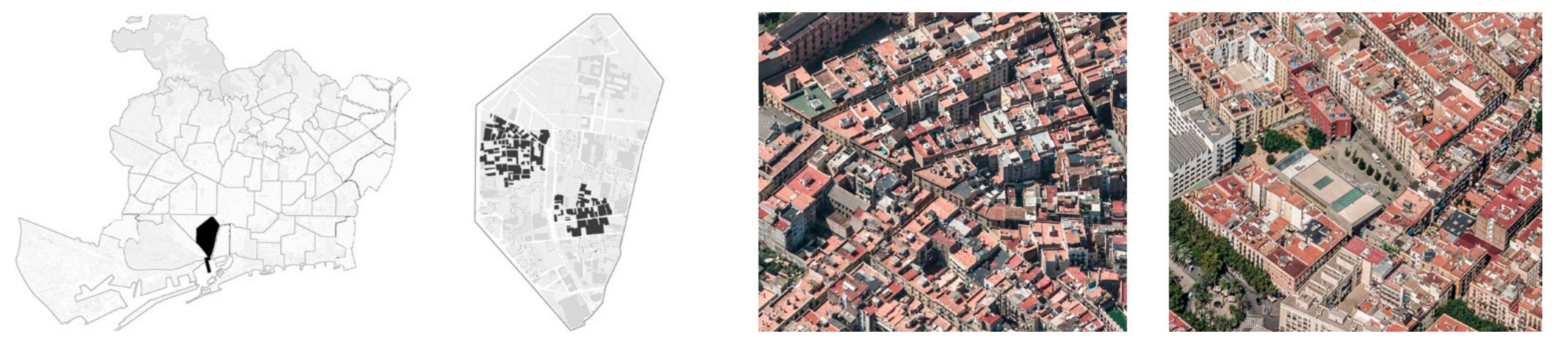
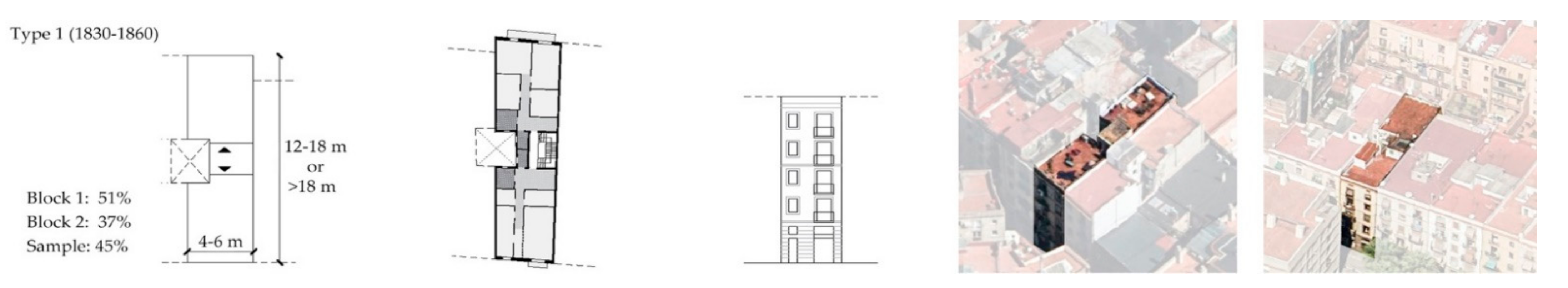
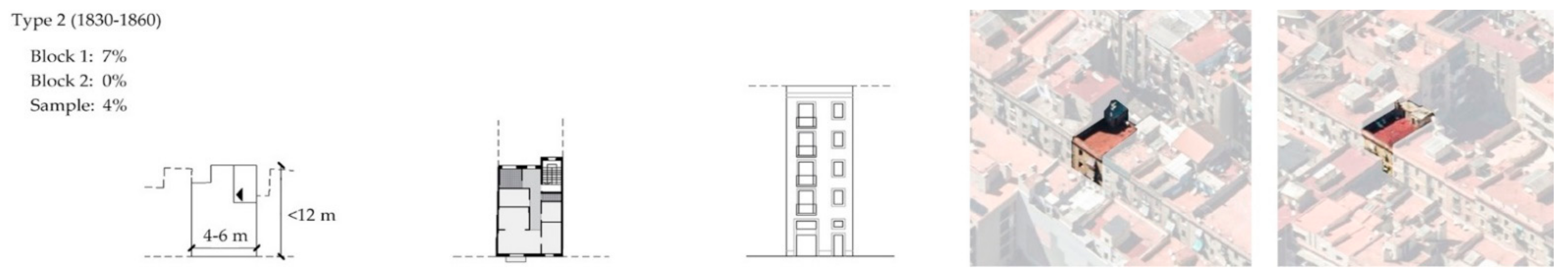
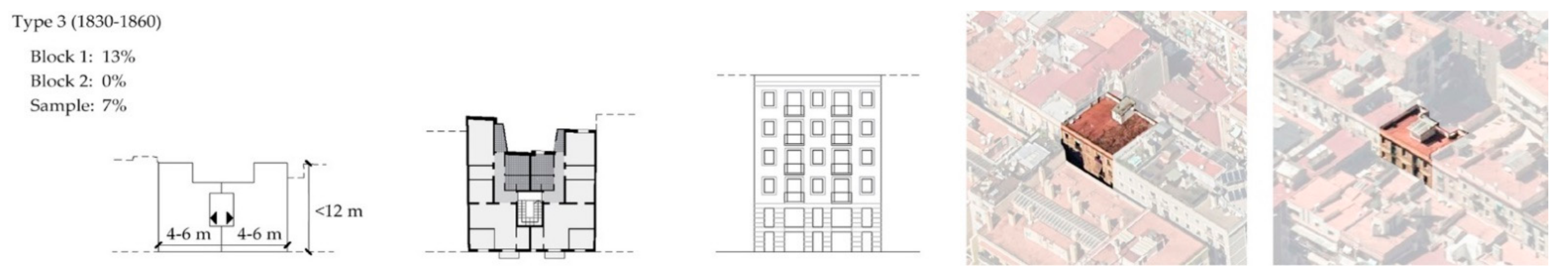
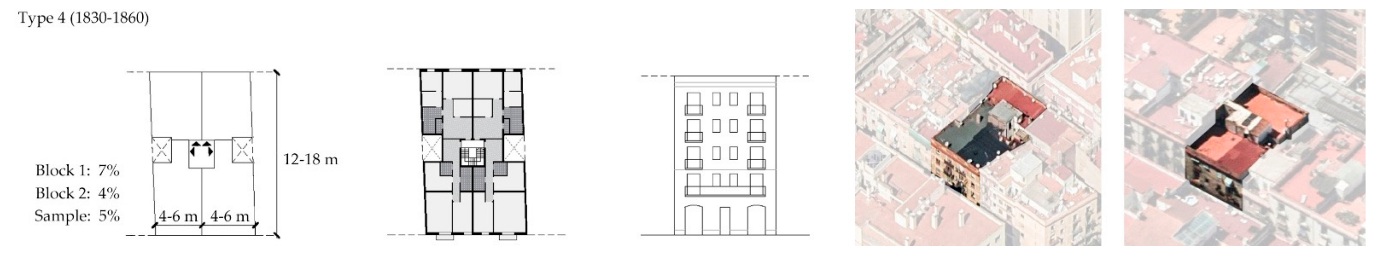
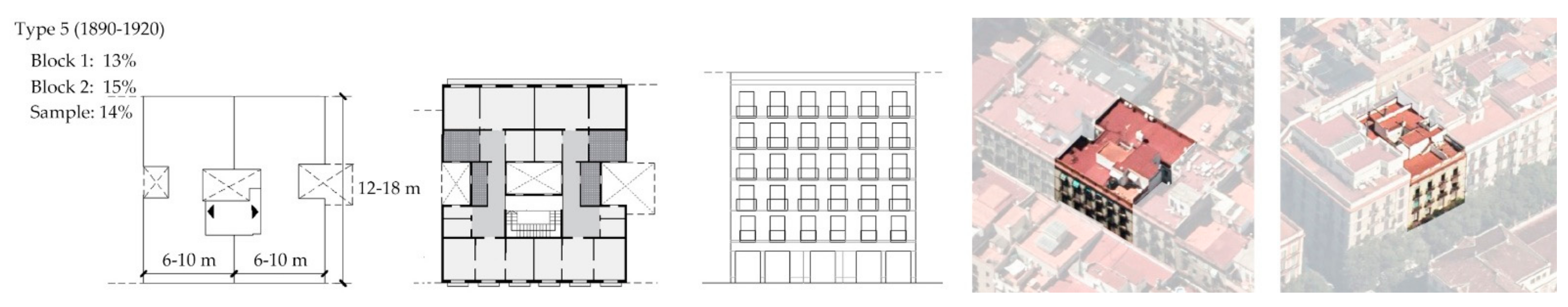
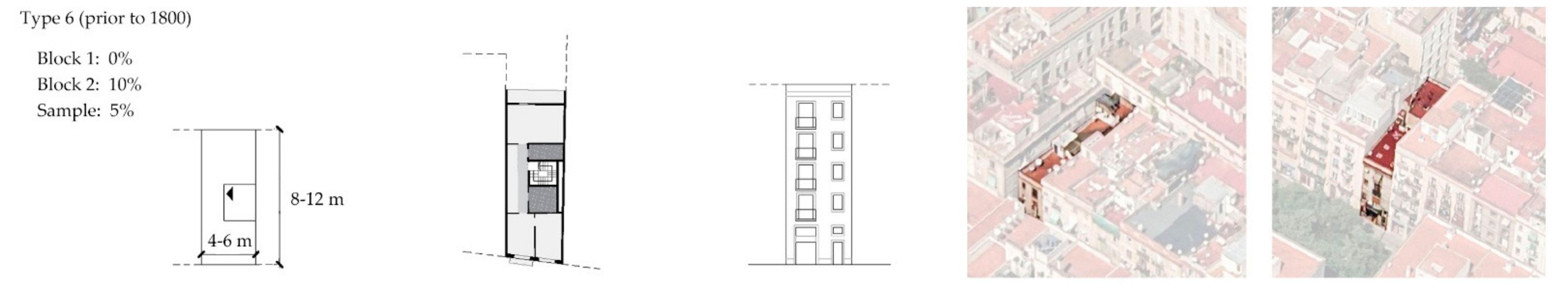
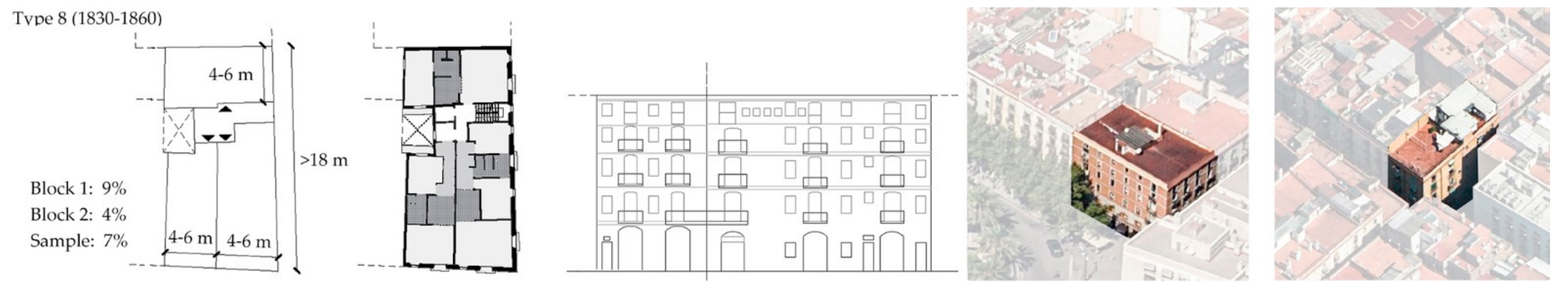
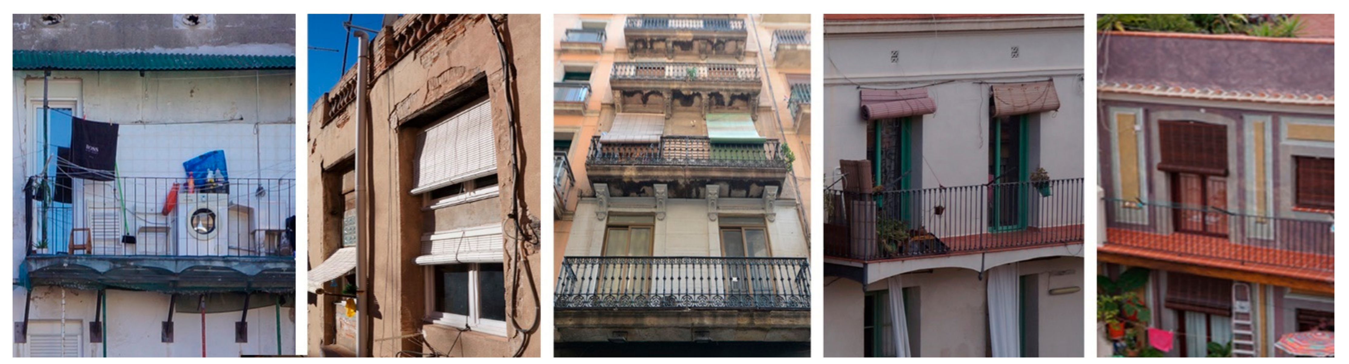
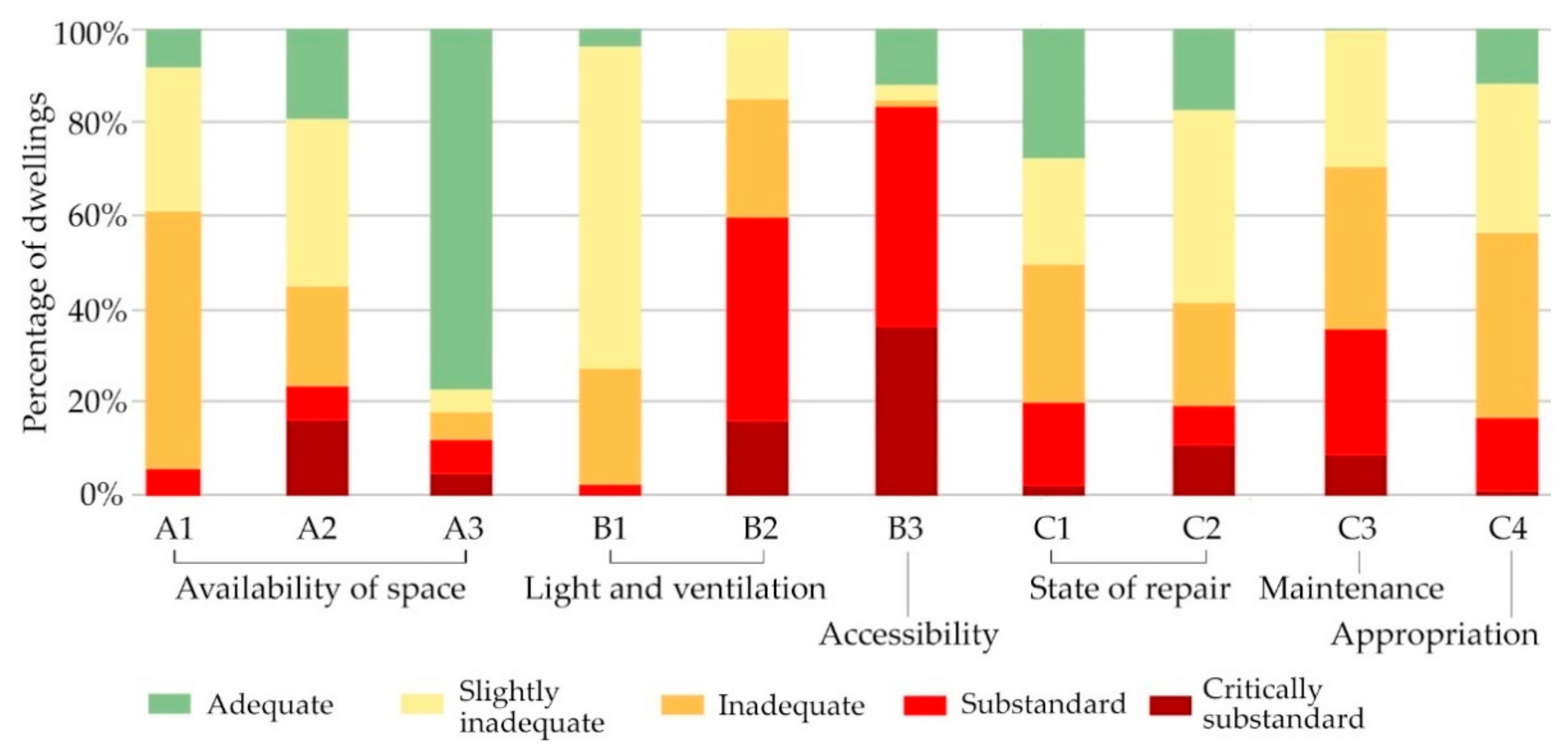
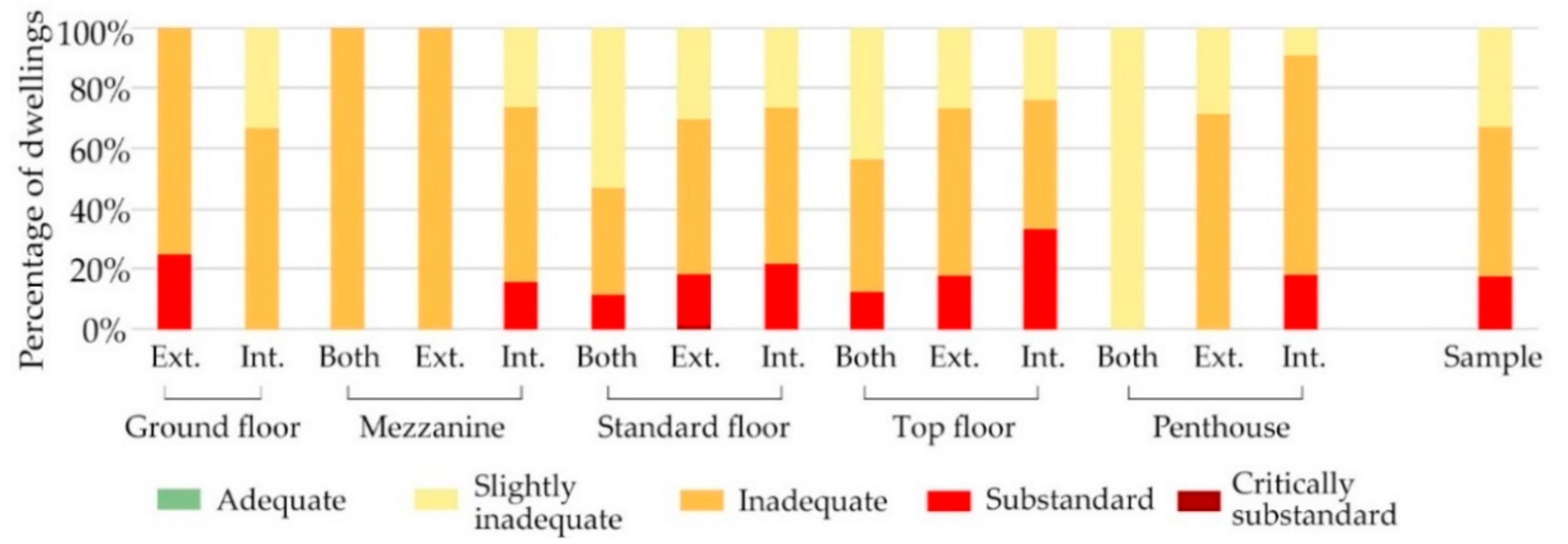
Table 1.
Types of dwellings according to location within the building, and percentage of dwelling types segmented by city block. Dwellings with one exterior façade that open only onto the street; dwellings with one interior façade that open only onto the inner urban courtyard; dwellings with two façades that open both onto the street and the courtyard (front and back of the building).
| Types of Dwelling | Block 1 | Block 2 | Sample |
|---|---|---|---|
| Ground floor with one exterior façade | 3.8% | 0.0% | 2.0% |
| Ground floor with one interior façade | 1.6% | 0.7% | 1.2% |
| Mezzanine with two façades | 0.9% | 0.0% | 0.5% |
| Mezzanine with one exterior façade | 0.9% | 0.0% | 0.5% |
| Mezzanine with one interior façade | 5.0% | 1.1% | 3.2% |
| Upper floors with two façades | 9.0% | 30.1% | 19.1% |
| Upper floors with one exterior façade | 30.2% | 22.7% | 27.0% |
| Upper floors with one interior façade | 23.7% | 18.4% | 21.4% |
| Top floor with two façades | 2.8% | 8.2% | 5.4% |
| Top floor with one exterior façade | 10.3% | 8.2% | 9.4% |
| Top floor with one interior façade | 7.8% | 6.0% | 7.0% |
| Penthouse with two façades | 0.0% | 0.7% | 0.3% |
| Exterior penthouse | 0.3% | 2.1% | 1.2% |
| Interior penthouse | 2.2% | 1.4% | 1.8% |
Table 2.
Standard indicators and scores. A1-B3 refers to the subgroups of indicators explained in this section. Sources for legal standards are specified in each indicator. Text in italics indicates contextual criteria used in the absence of official regulations.
Table 2.
Standard indicators and scores. A1-B3 refers to the subgroups of indicators explained in this section. Sources for legal standards are specified in each indicator. Text in italics indicates contextual criteria used in the absence of official regulations.
| Standard Indicators | Substandard Housing | Inadequate Housing | Adequate Housing | |||
|---|---|---|---|---|---|---|
| Critically Substandard | Substandard | Inadequate | Slightly Inadequate | Adequate | Above Adequate | |
| A1 Usable dwelling area [67,92] | <15 m2 | 15–20 m2 | <36 m2 | 30–60 m2 [92] | 60–120 m2 [92] | >120 m2 [92] |
| A1 Dimensions of entranceway [120,121] | - | - | Width < 2.2 m Depth < 2 m | Depends on context | Depends on context | Depends on context |
| A2 Usable dwelling area (s)/resident (n) [119,121] | s<8+8n [121] | - | s<16+10n [119] | - | s>16+10n [119] | - |
| A3 Predominant use of exterior private spaces or common spaces (overcrowding signs) [120,121] | - | - | Insufficient room for hanging clothes | Insufficient space for recreational use | Insufficient space for multiple uses | Ample space |
| B1 Distance to the most distant opposing façade [67,92,120,121] | <1.8 m | 1.8–3 m | 3–4.5 m [92] | 4.5–6 m [92] | >6 m [92] | Depends on context |
| B1 Surface area of lightwell [67,92] | <4 m2 | 4–9 m2 | 9–13 m2 | Depends on context | Courtyard [92] | >Courtyard [92] |
| B1 Smallest dimension of lightwell [67,92,93] | <2 m | <1/7 height (m) | <3 m | 3–6 m [92,93] | >6 m [92,93] | Depends on context |
| B1 Exterior perimeter [92,121] | - | <interior surface area/16 [92] | <interior surface area/12 | <interior surface area/9 | >interior surface area/9 | Depends on context |
| B1 Façade width [67,92] | <2.2 m | - | 2.2–4.5 m | 4.5–6.5 m [92] | 6.5–10 m [92] | >10 m [92] |
| B2 Ventilation of stairwell [120,121] | - | - | Inexistent | Insufficient (does not meet standards for courtyards) | Sufficient (meets standards for courtyards) | Good (legal courtyard) |
| B2 Natural illumination of entryway [120,121] | - | - | Inexistent | No transparency | Illumination and transparency | Depends on context |
| B2 Natural illumination of stairwell [120,121] | - | - | Inexistent | Insufficient (does not meet standards for courtyards | Sufficient (patio and stairway bulkhead meet standards) | Good (legal courtyard and stairway bulkhead) |
| B3 Availability of elevator [67] | 5 stories or more without elevator | 4 stories without elevator | 3 stories without elevator | 2 stories without elevator | Has elevator | - |
| B3 Accessibility of front door [120,121] | <0.8 m wide or <2 m tall | High step at entrance | Low step at entrance | - | >0.8 m wide or >2 m tall, no steps | |
| B3 Accessibility of entryway [120,121] | <1.2 m wide | Includes steps | Width < 2.2 | - | Width > 2.2, no steps | |
Table 3.
Habitability dimensions for which a weighted sum of indicators was prepared along with their weight in relation to the availability of space, ventilation and illumination, accessibility and state of repair.
Table 3.
Habitability dimensions for which a weighted sum of indicators was prepared along with their weight in relation to the availability of space, ventilation and illumination, accessibility and state of repair.
| Habitability Dimensions | Indicator Subgroup | Weights |
|---|---|---|
| Availability of space | Usable area (A1) | 0.19 |
| Usable space/resident (A2) | 0.72 | |
| Overcrowding signs (A3) | 0.08 | |
| Light and ventilation | Ventilation and illumination of dwelling interiors (B1) | 0.8 |
| Ventilation and illumination of common spaces (B2) | 0.2 | |
| Accessibility | Accessibility (B3) | 1 |
| State of repair | State of repair of dwellings (C1) | 0.20 |
| State of repair of common spaces (C2) | 0.33 | |
| Maintenance (C3) | 0.33 | |
| Appropriation (C4) | 0.14 |
Table 4.
Overall habitability evaluation.
| Overall Evaluation | Dimension | Weights |
|---|---|---|
| Habitability | Availability of space (A) | 0.37 |
| Light and ventilation (B1 + B2) | 0.12 | |
| Accessibility (B3) | 0.16 | |
| State of repair (C) | 0.35 |
Publisher’s Note: MDPI stays neutral with regard to jurisdictional claims in published maps and institutional affiliations. |
© 2021 by the authors. Licensee MDPI, Basel, Switzerland. This article is an open access article distributed under the terms and conditions of the Creative Commons Attribution (CC BY) license (https://creativecommons.org/licenses/by/4.0/).
Share and Cite
MDPI and ACS Style
Vima-Grau, S.; Cornadó, C.; Ravetllat, P.-J.; Garcia-Almirall, P. Multiscale Integral Assessment of Habitability in the Case of El Raval in Barcelona. Sustainability 2021, 13, 4598. https://doi.org/10.3390/su13094598
AMA Style
Vima-Grau S, Cornadó C, Ravetllat P-J, Garcia-Almirall P. Multiscale Integral Assessment of Habitability in the Case of El Raval in Barcelona. Sustainability. 2021; 13(9):4598. https://doi.org/10.3390/su13094598
Chicago/Turabian StyleVima-Grau, Sara, Còssima Cornadó, Pere-Joan Ravetllat, and Pilar Garcia-Almirall. 2021. "Multiscale Integral Assessment of Habitability in the Case of El Raval in Barcelona" Sustainability 13, no. 9: 4598. https://doi.org/10.3390/su13094598
Note that from the first issue of 2016, this journal uses article numbers instead of page numbers. See further details here.