Using Disaster Outcomes to Validate Components of Social Vulnerability to Floods: Flood Deaths and Property Damage across the USA


Abstract
:1. Introduction
1.1. From Risk to Vulnerability
1.2. Measuring and Validating Social Vulnerability to Flood Hazards
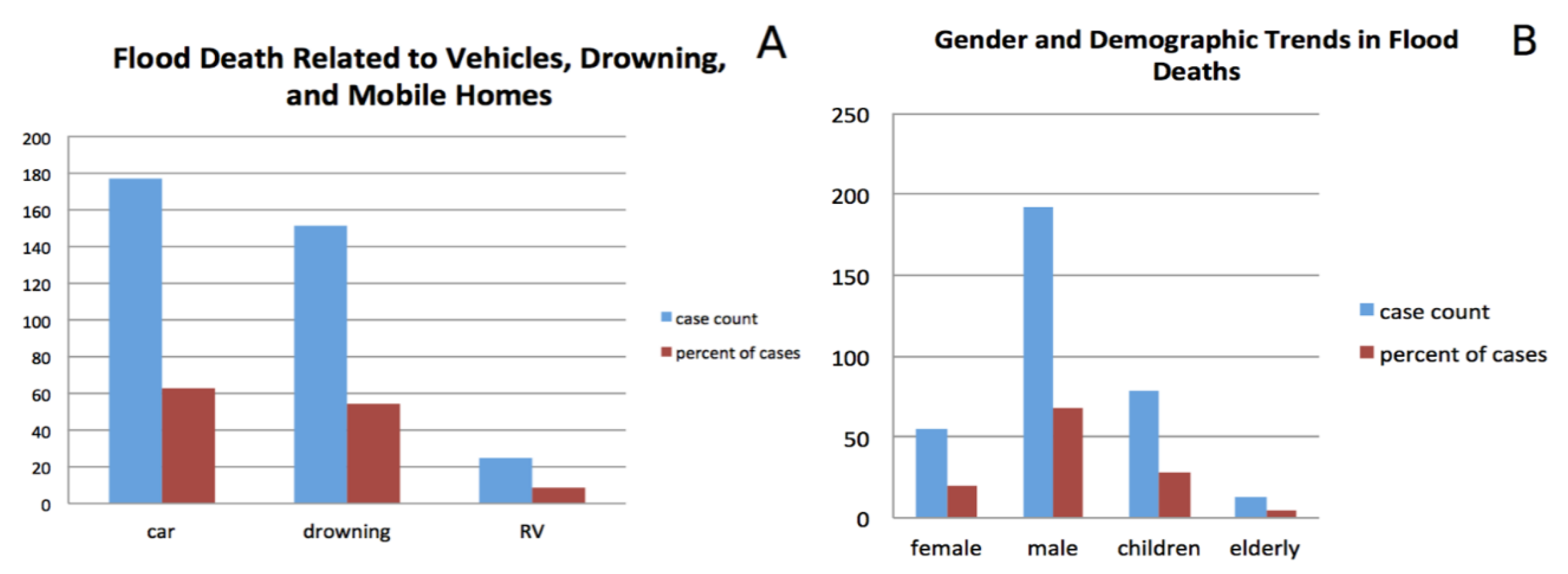
1.2.1. Flood Fatality
1.2.2. Property Damage
1.3. Validating Social Vulnerability Based on Disaster Outcomes
- Which demographic variables predict fatalities directly attributed to floods?
- Which demographic variables are associated with higher relative flood property damages?
- Does a composite index of social vulnerability (SoVI) correlate with flood death and damage when accounting for hazard intensity?
- Which populations and their locations are most likely to experience death and damage in a large (500-year) future flood event?
2. Materials and Methods
2.1. Data
2.1.1. Property and Fatality Data
2.1.2. Flood Hazard Magnitude and Built Environment Data
2.1.3. Social Vulnerability Data
2.2. Regression Models
2.3. Variable Selection and Model Construction
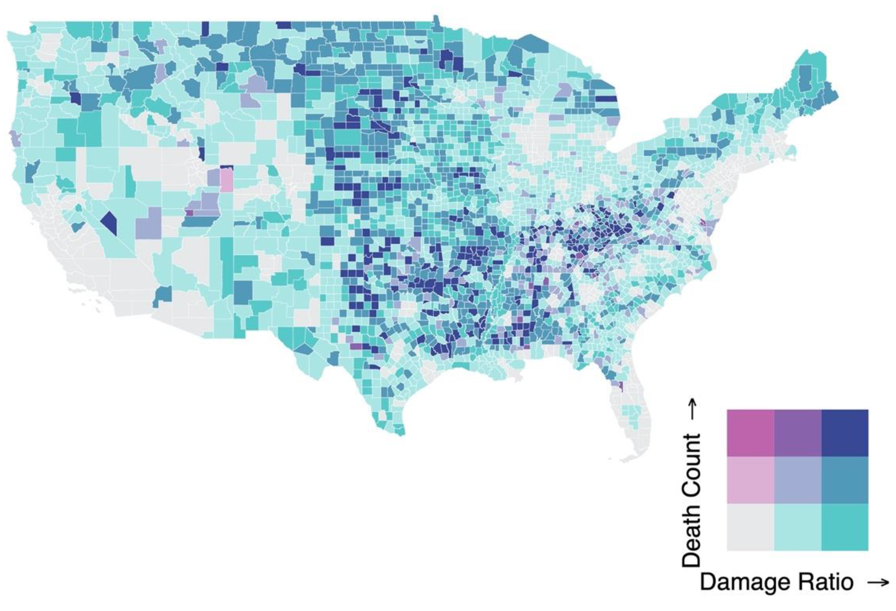
2.4. Predictive Maps
3. Results
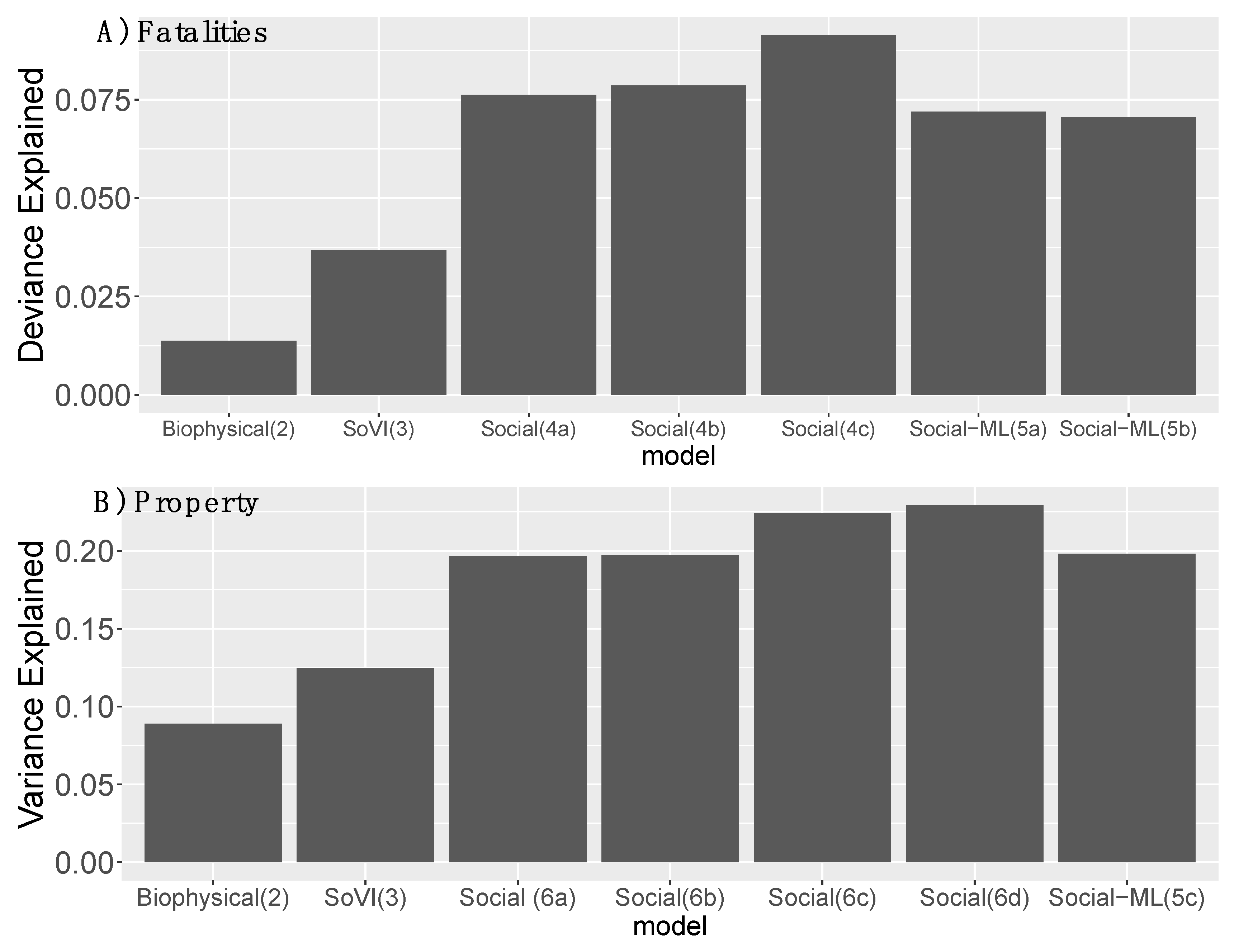
3.1. Fatalities
3.2. Property Damage
3.3. Social versus Biophysical Influence Explaining Variation in Death and Damage
3.4. Predicted Spatial Distribution of Death and Damage in a 500-Year Flood Event
4. Discussion
4.1. Flood Fatalities
4.2. Property Damage
4.3. Spatial Distribution of Death and Damage and Model Limitations
4.4. Further Research Needs
5. Conclusions
Author Contributions
Funding
Acknowledgments
Conflicts of Interest
Data Availability
References
- Burton, I. The Environment as Hazard; Guilford Press: New York, NY, USA, 1993; ISBN 0-89862-159-3. [Google Scholar]
- Kates, R.W.; Burton, I. Gilbert F. White, 1911–2006 Local Legacies, National Achievements, and Global Visions. Ann. Assoc. Am. Geogr. 2008, 98, 479–486. [Google Scholar] [CrossRef]
- Watts, M. On the poverty of theory: Natural hazards research in context. In Interpretations of Calamity from the Viewpoint of Human Ecology; Hewitt, K., Ed.; Allen & Unwin: Boston, MA, USA, 1983; pp. 231–262. [Google Scholar]
- Blaikie, P.; Terry, C.; Ian, D.; Ben, W. At Risk: Natural Hazards, People’s Vulnerability, and Disasters. Hum. Ecol. 1996, 24, 141–145. [Google Scholar] [CrossRef]
- Cutter, S.L. Vulnerability to environmental hazards. Prog. Hum. Geogr. 1996, 20, 529–539. [Google Scholar] [CrossRef]
- Turner, B.L.; Kasperson, R.E.; Matson, P.A.; McCarthy, J.J.; Corell, R.W.; Christensen, L.; Eckley, N.; Kasperson, J.X.; Luers, A.; Martello, M.L.; et al. A framework for vulnerability analysis in sustainability science. Proc. Natl. Acad. Sci. USA 2003, 100, 8074–8079. [Google Scholar] [CrossRef] [PubMed] [Green Version]
- White, G.F. Natural Hazards, Local, National, Global; Oxford University Press: Oxford, UK, 1974. [Google Scholar]
- Adger, W.N. Vulnerability. Glob. Environ. Chang. 2006, 16, 268–281. [Google Scholar] [CrossRef]
- Birkmann, J.; Wisner, B. Measuring the Unmeasurable: The Challenge of Vulnerability; UNU-EHS: Bonn, Germany, 2006; ISBN 3-9810582-6-7. [Google Scholar]
- Eakin, H.; Luers, A.L. Assessing the Vulnerability of Social-Environmental Systems. Annu. Rev. Environ. Resour. 2006, 31, 365–394. [Google Scholar] [CrossRef] [Green Version]
- Eriksen, S.H.; Kelly, P.M. Developing Credible Vulnerability Indicators for Climate Adaptation Policy Assessment. Mitig. Adapt. Strateg. Glob. Chang. 2007, 12, 495–524. [Google Scholar] [CrossRef]
- IPCC Climate Change 2014—Impacts, Adaptation and Vulnerability: Regional Aspects; Cambridge University Press: Cambridge, UK, 2014.
- Smit, B.; Wandel, J. Adaptation, adaptive capacity, and vulnerability. Glob. Environ. Chang. 2006, 16, 282–292. [Google Scholar] [CrossRef]
- Ford, J.D.; Smit, B. A Framework for Assessing the Vulnerability of Communities in the Canadian Arctic to Risks Associated with Climate Change. ARCTIC 2004, 57, 389–400. [Google Scholar] [CrossRef]
- Younus, M.; Kabir, M. Climate Change Vulnerability Assessment and Adaptation of Bangladesh: Mechanisms, Notions and Solutions. Sustainability 2018, 10, 4286. [Google Scholar] [CrossRef] [Green Version]
- Mustafa, D. The Production of an Urban Hazardscape in Pakistan: Modernity, Vulnerability, and the Range of Choice. Ann. Assoc. Am. Geogr. 2005, 95, 566–586. [Google Scholar] [CrossRef]
- Turner, B.L.; Matson, P.A.; McCarthy, J.J.; Corell, R.W.; Christensen, L.; Eckley, N.; Hovelsrud-Broda, G.K.; Kasperson, J.X.; Kasperson, R.E.; Luers, A.; et al. Illustrating the coupled human-environment system for vulnerability analysis: Three case studies. Proc. Natl. Acad. Sci. USA 2003, 100, 8080–8085. [Google Scholar] [CrossRef] [PubMed] [Green Version]
- Schoon, M.; Fabricius, C.; Anderies, J.M.; Nelson, M. Synthesis: Vulnerability, traps, and transformations—long-term perspectives from archaeology. Ecol. Soc. 2011, 16, 24. [Google Scholar] [CrossRef] [Green Version]
- Yoon, D.K. Assessment of social vulnerability to natural disasters: A comparative study. Nat. Hazards 2012, 63, 823–843. [Google Scholar] [CrossRef]
- O’Brien, K.; Sygna, L.; Haugen, J.E. Vulnerable or Resilient? A Multi-Scale Assessment of Climate Impacts and Vulnerability in Norway. Clim. Chang. 2004, 64, 193–225. [Google Scholar] [CrossRef]
- Younus, M.A.F. An assessment of vulnerability and adaptation to cyclones through impact assessment guidelines: A bottom-up case study from Bangladesh coast. Nat. Hazards 2017, 89, 1437–1459. [Google Scholar] [CrossRef]
- Younus, M.A.F.; Harvey, N. Community-based flood vulnerability and adaptation assessment: A case study from Bangladesh. J. Environ. Assess. Policy Manag. 2013, 15, 1350010. [Google Scholar] [CrossRef]
- Rickless, D.S.; Yao, X.A.; Orland, B.; Welch-Devine, M. Assessing Social Vulnerability through a Local Lens: An Integrated Geovisual Approach. Ann. Am. Assoc. Geogr. 2020, 110, 36–55. [Google Scholar] [CrossRef]
- Tanim, S.H.; Tobin, G.A. Social Factors and Evacuation Vulnerability: An Application in Pinellas County, Florida. Pap. Appl. Geogr. 2018, 4, 123–136. [Google Scholar] [CrossRef]
- Shao, W.; Jackson, N.P.; Ha, H.; Winemiller, T. Assessing community vulnerability to floods and hurricanes along the Gulf Coast of the United States. Disasters 2020, 44, 518–547. [Google Scholar] [CrossRef]
- Cutter, S.L.; Boruff, B.J.; Shirley, W.L. Social vulnerability to environmental hazards. Soc. Sci. Q. 2003, 84, 242–261. [Google Scholar] [CrossRef]
- Gu, H.; Du, S.; Liao, B.; Wen, J.; Wang, C.; Chen, R.; Chen, B. A hierarchical pattern of urban social vulnerability in Shanghai, China and its implications for risk management. Sustain. Cities Soc. 2018, 41, 170–179. [Google Scholar] [CrossRef]
- Cutter, S.L.; Finch, C. Temporal and spatial changes in social vulnerability to natural hazards. Proc. Natl. Acad. Sci. USA 2008, 105, 2301–2306. [Google Scholar] [CrossRef] [PubMed] [Green Version]
- Federal Emergency Management Agency National Risk Index. Available online: https://nationalriskindex-test.fema.gov/ (accessed on 27 July 2017).
- De Sherbinin, A.; Apotsos, A.; Chevrier, J. Mapping the future: Policy applications of climate vulnerability mapping in West Africa. Geogr. J. 2017, 183, 414–425. [Google Scholar] [CrossRef]
- Spielman, S.E.; Tuccillo, J.; Folch, D.C.; Schweikert, A.; Davies, R.; Wood, N.; Tate, E. Evaluating social vulnerability indicators: Criteria and their application to the Social Vulnerability Index. Nat. Hazards 2020, 100, 417–436. [Google Scholar] [CrossRef] [Green Version]
- Tate, E. Social vulnerability indices: A comparative assessment using uncertainty and sensitivity analysis. Nat. Hazards 2012, 63, 325–347. [Google Scholar] [CrossRef]
- Tate, E. Uncertainty Analysis for a Social Vulnerability Index. Ann. Assoc. Am. Geogr. 2013, 103, 526–543. [Google Scholar] [CrossRef]
- Rufat, S.; Tate, E.; Emrich, C.T.; Antolini, F. How Valid Are Social Vulnerability Models? Ann. Am. Assoc. Geogr. 2019, 109, 1131–1153. [Google Scholar] [CrossRef]
- De Sherbinin, A.; Bukvic, A.; Rohat, G.; Gall, M.; McCusker, B.; Preston, B.; Apotsos, A.; Fish, C.; Kienberger, S.; Muhonda, P.; et al. Climate vulnerability mapping: A systematic review and future prospects. Wiley Interdiscip. Rev. Clim. Chang. 2019. [Google Scholar] [CrossRef]
- Adger, W.N. Social and ecological resilience: Are they related? Prog. Hum. Geogr. 2000, 24, 347–364. [Google Scholar] [CrossRef]
- Adger, W.N.; Huq, S.; Brown, K.; Conway, D.; Hulme, M. Adaptation to climate change in the developing world. Prog. Dev. Stud. 2003, 3, 179–195. [Google Scholar] [CrossRef]
- Denevan, W.M. Adaptation, variation, and cultural geography. Prof. Geogr. 1983, 35, 399–407. [Google Scholar] [CrossRef]
- Eakin, H. The ‘turn to capacity’ in vulnerability research. In Applied Studies in Climate Adaptation; Palutikof, J.P., Boulter, S.L., Barnett, J., Rissik, D., Eds.; John Wiley & Sons Ltd.: Hoboken, NJ, USA, 2014; pp. 225–230. [Google Scholar]
- Holling, C.S. Understanding the complexity of economic, ecological, and social systems. Ecosystems 2001, 4, 390–405. [Google Scholar] [CrossRef]
- Kates, R.W.; Travis, W.R.; Wilbanks, T.J. Transformational adaptation when incremental adaptations to climate change are insufficient. Proc. Natl. Acad. Sci. USA 2012, 109, 7156–7161. [Google Scholar] [CrossRef] [Green Version]
- Turner, B.L. Vulnerability and resilience: Coalescing or paralleling approaches for sustainability science? Glob. Environ. Chang. 2010, 20, 570–576. [Google Scholar] [CrossRef]
- Wise, R.M.; Fazey, I.; Stafford Smith, M.; Park, S.E.; Eakin, H.C.; Archer Van Garderen, E.R.M.; Campbell, B. Reconceptualising adaptation to climate change as part of pathways of change and response. Glob. Environ. Chang. 2014, 28, 325–336. [Google Scholar] [CrossRef] [Green Version]
- Fischer, A.P.; Frazier, T.G. Social Vulnerability to Climate Change in Temperate Forest Areas: New Measures of Exposure, Sensitivity, and Adaptive Capacity. Ann. Am. Assoc. Geogr. 2018, 108, 658–678. [Google Scholar] [CrossRef]
- Lutz, W.; Muttarak, R.; Striessnig, E. Universal education is key to enhanced climate adaptation. Science 2014, 346, 1061–1062. [Google Scholar] [CrossRef]
- Cutter, S.L.; Ahearn, J.A.; Amadei, B.; Crawford, P.; Eide, E.A.; Galloway, G.E.; Goodchild, M.F.; Kunreuther, H.C.; Li-Vollmer, M.; Schoch-Spana, M.; et al. Disaster resilience: A national imperative. Environ. Sci. Policy Sustain. Dev. 2013, 55, 25–29. [Google Scholar] [CrossRef]
- Luers, A.L. The surface of vulnerability: An analytical framework for examining environmental change. Glob. Environ. Chang. Part A 2005, 15, 214–223. [Google Scholar] [CrossRef]
- Cutter, S.L.; Derakhshan, S. Temporal and spatial change in disaster resilience in US counties, 2010–2015. Environ. Hazards 2020, 19, 10–29. [Google Scholar] [CrossRef]
- Bakkensen, L.A.; Fox-Lent, C.; Read, L.K.; Linkov, I. Validating Resilience and Vulnerability Indices in the Context of Natural Disasters: Validating Resilience and Vulnerability Indices. Risk Anal. 2017, 37, 982–1004. [Google Scholar] [CrossRef] [PubMed] [Green Version]
- Jongman, B.; Hochrainer-stigler, S.; Feyen, L.; Aerts, J.C.J.H.; Mechler, R.; Botzen, W.J.W.; Bouwer, L.M.; Pflug, G.; Rojas, R.; Ward, P.J. Increasing stress on disaster-risk finance due to large floods. Nat. Clim. Chang. 2014, 4, 1–5. [Google Scholar] [CrossRef]
- Jongman, B.; Ward, P.J.; Aerts, J.C.J.H. Global exposure to river and coastal flooding: Long term trends and changes. Glob. Environ. Chang. 2012, 22, 823–835. [Google Scholar] [CrossRef]
- Ward, P.J.; Jongman, B.; Weiland, F.S.; Bouwman, A.; van Beek, R.; Bierkens, M.F.P.; Ligtvoet, W.; Winsemius, H.C. Assessing flood risk at the global scale: Model setup, results, and sensitivity. Environ. Res. Lett. 2013, 8, 44019. [Google Scholar] [CrossRef]
- Winsemius, H.C.; Van Beek, L.P.H.; Jongman, B.; Ward, P.J.; Bouwman, A. A framework for global river flood risk assessments. Hydrol. Earth Syst. Sci. 2013, 17, 1871–1892. [Google Scholar] [CrossRef] [Green Version]
- Smith, A.; Bates, P.D.; Wing, O.; Sampson, C.; Quinn, N.; Neal, J. New estimates of flood exposure in developing countries using high-resolution population data. Nat. Commun. 2019, 10. [Google Scholar] [CrossRef] [Green Version]
- Wing, O.E.J.; Bates, P.D.; Smith, A.M.; Sampson, C.C.; Johnson, K.A.; Fargione, J.; Morefield, P. Estimates of present and future flood risk in the conterminous United States. Environ. Res. Lett. 2018, 13, 034023. [Google Scholar] [CrossRef]
- Nofal, O.M.; van de Lindt, J.W. Understanding flood risk in the context of community resilience modeling for the built environment: Research needs and trends. Sustain. Resilient Infrastruct. 2020, 1–17. [Google Scholar] [CrossRef]
- Mustafa, D. Reinforcing vulnerability? Disaster relief, recovery, and response to the 2001 flood in Rawalpindi, Pakistan. Glob. Environ. Chang. Part B Environ. Hazards 2003, 5, 71–82. [Google Scholar] [CrossRef]
- Rufat, S.; Tate, E.; Burton, C.G.; Maroof, A.S. Social vulnerability to floods: Review of case studies and implications for measurement. Int. J. Disaster Risk Reduct. 2015, 14, 470–486. [Google Scholar] [CrossRef] [Green Version]
- Azar, D.; Rain, D. Identifying population vulnerable to hydrological hazards in San Juan, Puerto Rico. GeoJournal 2007, 69, 23–43. [Google Scholar] [CrossRef]
- Fekete, A. Validation of a social vulnerability index in context to river-floods in Germany. Nat. Hazards Earth Syst. Sci. 2009, 9, 393–403. [Google Scholar] [CrossRef] [Green Version]
- Finch, C.; Emrich, C.T.; Cutter, S.L. Disaster disparities and differential recovery in New Orleans. Popul. Environ. 2010, 31, 179–202. [Google Scholar] [CrossRef]
- Parry, L.; Davies, G.; Almeida, O.; Frausin, G.; de Moraés, A.; Rivero, S.; Filizola, N.; Torres, P. Social Vulnerability to Climatic Shocks Is Shaped by Urban Accessibility. Ann. Am. Assoc. Geogr. 2018, 108, 125–143. [Google Scholar] [CrossRef] [Green Version]
- Younus, M.A.F.; Harvey, N. Economic consequences of failed autonomous adaptation to extreme floods: A case study from Bangladesh. Local Econ. J. Local Econ. Policy Unit 2014, 29, 22–37. [Google Scholar] [CrossRef]
- Raker, E.J. Natural Hazards, Disasters, and Demographic Change: The Case of Severe Tornadoes in the United States, 1980–2010. Demography 2020, 57, 653–674. [Google Scholar] [CrossRef]
- Emrich, C.T.; Tate, E.; Larson, S.E.; Zhou, Y. Measuring social equity in flood recovery funding. Environ. Hazards 2020, 19, 228–250. [Google Scholar] [CrossRef]
- Abbas, H.B.; Routray, J.K. Vulnerability to flood-induced public health risks in Sudan. Disaster Prev. Manag. Int. J. 2014, 23, 395–419. [Google Scholar] [CrossRef]
- Alderman, K.; Turner, L.R.; Tong, S. Floods and human health: A systematic review. Environ. Int. 2012, 47, 37–47. [Google Scholar] [CrossRef] [Green Version]
- Fothergill, A. Gender, risk, and disaster. Int. J. Mass Emergencies Disasters 1996, 14, 33–56. [Google Scholar]
- Neumayer, E.; Plümper, T. The Gendered Nature of Natural Disasters: The Impact of Catastrophic Events on the Gender Gap in Life Expectancy, 1981–2002. Ann. Assoc. Am. Geogr. 2007, 97, 551–566. [Google Scholar] [CrossRef] [Green Version]
- Chowdhury, A.M.R.; Bhuyia, A.U.; Choudhury, A.Y.; Sen, R. The Bangladesh cyclone of 1991: Why so many people died. Disasters 1993, 17, 291–304. [Google Scholar] [CrossRef] [PubMed]
- Ashley, S.T.; Ashley, W.S. Flood Fatalities in the United States. J. Appl. Meteorol. Climatol. 2008, 47, 805–818. [Google Scholar] [CrossRef]
- Jonkman, S.N.; Kelman, I. An analysis of the causes and circumstances of flood disaster deaths. Disasters 2005, 29, 75–97. [Google Scholar] [CrossRef] [PubMed]
- Lowe, D.; Ebi, K.; Forsberg, B. Factors Increasing Vulnerability to Health Effects before, during and after Floods. Int. J. Environ. Res. Public. Health 2013, 10, 7015–7067. [Google Scholar] [CrossRef] [PubMed]
- Ngo, E.B. When disasters and age collide: Reviewing vulnerability of the elderly. Nat. Hazards Rev. 2001, 2, 80–89. [Google Scholar] [CrossRef]
- Peek, L. Children and disasters: Understanding vulnerability, developing capacities, and promoting resilience—An introduction. Child. Youth Environ. 2008, 18, 1–29. [Google Scholar]
- Fothergill, A.; Maestas, E.G.; Darlington, J.D. Race, ethnicity and disasters in the United States: A review of the literature. Disasters 1999, 23, 156–173. [Google Scholar] [CrossRef]
- Sharkey, P. Survival and Death in New Orleans: An Empirical Look at the Human Impact of Katrina. J. Black Stud. 2007, 37, 482–501. [Google Scholar] [CrossRef]
- Brunkard, J.; Namulanda, G.; Ratard, R. Hurricane Katrina Deaths, Louisiana, 2005. Disaster Med. Public Health Prep. 2008, 2, 215–223. [Google Scholar] [CrossRef] [PubMed] [Green Version]
- Zahran, S.; Brody, S.D.; Peacock, W.G.; Vedlitz, A.; Grover, H. Social vulnerability and the natural and built environment: A model of flood casualties in Texas. Disasters 2008, 32, 537–560. [Google Scholar] [CrossRef] [PubMed]
- Rivera, J.D.; Miller, D.S. Continually Neglected: Situating Natural Disasters in the African American Experience. J. Black Stud. 2007, 37, 502–522. [Google Scholar] [CrossRef]
- Jongman, B.; Winsemius, H.C.; Aerts, J.C.J.H.; Coughlan de Perez, E.; van Aalst, M.K.; Kron, W.; Ward, P.J. Declining vulnerability to river floods and the global benefits of adaptation. Proc. Natl. Acad. Sci. USA 2015, 201414439. [Google Scholar] [CrossRef] [Green Version]
- Di Baldassarre, G.; Montanari, A.; Lins, H.; Koutsoyiannis, D.; Brandimarte, L.; Blöschl, G. Flood fatalities in Africa: From diagnosis to mitigation: FLOOD FATALITIES IN AFRICA. Geophys. Res. Lett. 2010, 37, 1–5. [Google Scholar] [CrossRef] [Green Version]
- Formetta, G.; Feyen, L. Empirical evidence of declining global vulnerability to climate-related hazards. Glob. Environ. Chang. 2019, 57, 101920. [Google Scholar] [CrossRef] [PubMed]
- Federal Interagency Committee on Emergency Medical Services 2011 National EMS Assessment; National Highway Traffic Safety Administration, DOT HS; The National Academies Presss: Washington, DC, USA, 2011; p. 538.
- Minge, E.D.; National Cooperative Highway Research Program; National Cooperative Highway Research Program Synthesis Program; Transportation Research Board; National Academies of Sciences, Engineering, and Medicine. Emergency Medical Services Response to Motor Vehicle Crashes in Rural Areas; Transportation Research Board: Washington, DC, USA, 2013; ISBN 978-0-309-27104-2. [Google Scholar]
- Cutter, S.L.; Ash, K.D.; Emrich, C.T. Urban–Rural Differences in Disaster Resilience. Ann. Am. Assoc. Geogr. 2016, 1–17. [Google Scholar] [CrossRef]
- Lam, N.S.N.; Arenas, H.; Pace, K.; LeSage, J.; Campanella, R. Predictors of Business Return in New Orleans after Hurricane Katrina. PLoS ONE 2012, 7, e47935. [Google Scholar] [CrossRef] [PubMed]
- Zhang, Y.; Lindell, M.K.; Prater, C.S. Vulnerability of community businesses to environmental disasters. Disasters 2009, 33, 38–57. [Google Scholar] [CrossRef] [Green Version]
- Fothergill, A.; Peek, L.A. Poverty and disasters in the United States: A review of recent sociological findings. Nat. Hazards 2004, 32, 89–110. [Google Scholar] [CrossRef]
- Chinh, D.; Gain, A.; Dung, N.; Haase, D.; Kreibich, H. Multi-Variate Analyses of Flood Loss in Can Tho City, Mekong Delta. Water 2015, 8, 6. [Google Scholar] [CrossRef] [Green Version]
- Kelman, I.; Spence, R. A limit analysis of unreinforced masonry failing under flood water pressure. Mason. Int. 2003, 16, 51–61. [Google Scholar]
- Norris, F.H.; Smith, T.; Kaniasty, K. Revisiting the experience–behavior hypothesis: The effects of hurricane Hugo on hazard preparedness and other self-protective acts. Basic Appl. Soc. Psychol. 1999, 21, 37–47. [Google Scholar]
- Peacock, W.G.; Girard, C. Ethnic and racial inequalities in hurricane damage and insurance settlements. Hurric. Andrew Ethn. Gend. Sociol. Disasters 1997, 171–190. [Google Scholar]
- Elliott, J.R.; Pais, J. Race, class, and Hurricane Katrina: Social differences in human responses to disaster. Soc. Sci. Res. 2006, 35, 295–321. [Google Scholar] [CrossRef]
- Działek, J.; Biernacki, W.; Bokwa, A. Challenges to social capacity building in flood-affected areas of southern Poland. Nat. Hazards Earth Syst. Sci. 2013, 13, 2555–2566. [Google Scholar] [CrossRef]
- Khunwishit, S.; McEntire, D.A. Testing Social Vulnerability Theory: A Quantitative Study of Hurricane Katrina’s Perceived Impact on Residents living in FEMA Designated Disaster Areas. J. Homel. Secur. Emerg. Manag. 2012, 9, 16. [Google Scholar] [CrossRef]
- Kamel, N. Social Marginalisation, Federal Assistance and Repopulation Patterns in the New Orleans Metropolitan Area following Hurricane Katrina. Urban Stud. 2012, 49, 3211–3231. [Google Scholar] [CrossRef]
- Atreya, A.; Ferreira, S.; Michel-Kerjan, E. What drives households to buy flood insurance? New evidence from Georgia. Ecol. Econ. 2015, 117, 153–161. [Google Scholar] [CrossRef]
- Fothergill, A. Heads above Water: Gender, Class, and Family in the Grand Forks Flood; SUNY Press: New York, NY, USA, 2012; ISBN 0-7914-8472-6. [Google Scholar]
- American Society of Civil Engineers. 2012 Report Card For Texas’ Infrastructure; American Society of Civil Engineers: Reston, VA, USA, 2012. [Google Scholar]
- American Society of Civil Engineers. Flood Control in New Mexico; American Society of Civil Engineers: Reston, VA, USA, 2005. [Google Scholar]
- National Research Council Dam and Levee Safety and Community Resilience: A Vision for Future Practice; National Academies Press: Washington, DC, USA, 2012.
- Government Accounting Office (GAO) Flood Insurance: Participation of Indian Tribes in Federal and Private Programs; GAO: Washington, DC, USA, 2012.
- Qiang, Y.; Lam, N.S.N.; Cai, H.; Zou, L. Changes in Exposure to Flood Hazards in the United States. Ann. Am. Assoc. Geogr. 2017, 107, 1332–1350. [Google Scholar] [CrossRef]
- Koks, E.E.; Jongman, B.; Husby, T.G.; Botzen, W.J.W. Combining hazard, exposure and social vulnerability to provide lessons for flood risk management. Environ. Sci. Policy 2015, 47, 42–52. [Google Scholar] [CrossRef]
- Flanagan, B.E.; Gregory, E.W.; Hallisey, E.J.; Heitgerd, J.L.; Lewis, B. A Social Vulnerability Index for Disaster Management. J. Homel. Secur. Emerg. Manag. 2011, 8, 1–22. [Google Scholar] [CrossRef]
- Cutter, S.L.; Emrich, C.T. Social Vulnerability Index (SoVI®): Methodology and Limitations. Available online: https://data.femadata.com (accessed on 27 July 2017).
- Peacock, W.G.; Brody, S.D.; Seitz, W.A.; Merrell, W.J.; Vedlitz, A.; Zahran, S.; Harriss, R.C.; Stickney, R. Advancing Resilience of Coastal Localities: Developing, Implementing, and Sustaining the Use of Coastal Resilience Indicators: A Final Report; Hazard Reduction Recovery Center: College Station, TX, USA, 2010; pp. 1–148. [Google Scholar]
- Foster, K.A. In search of regional resilience. Urban Reg. Policy Its Eff. Build. Resilient Reg. 2012, 4, 24–59. [Google Scholar]
- Liu, D.; Li, Y. Social vulnerability of rural households to flood hazards in western mountainous regions of Henan province, China. Nat. Hazards Earth Syst. Sci. 2016, 16, 1123–1134. [Google Scholar] [CrossRef] [Green Version]
- Oulahen, G.; Mortsch, L.; Tang, K.; Harford, D. Unequal Vulnerability to Flood Hazards: “Ground Truthing” a Social Vulnerability Index of Five Municipalities in Metro Vancouver, Canada. Ann. Assoc. Am. Geogr. 2015, 105, 473–495. [Google Scholar] [CrossRef]
- Füssel, H.-M. Vulnerability: A generally applicable conceptual framework for climate change research. Glob. Environ. Chang. 2007, 17, 155–167. [Google Scholar] [CrossRef]
- Chen, C.; Noble, I.; Hellmann, J.; Coffee, J.; Murillo, M.; Chawla, N. University of Notre Dame Global Adaptation Index; University of Notre Dame: Notre Dame, IN, USA, 2015. [Google Scholar]
- Soares, M.B.; Gagnon, A.S.; Doherty, R.M. Conceptual elements of climate change vulnerability assessments: A review. Int. J. Clim. Chang. Strateg. Manag. 2012, 6–35. [Google Scholar] [CrossRef]
- Reckien, D.; Lwasa, S.; Satterthwaite, D.; McEvoy, D.; Creutzig, F.; Montgomery, M.; Schensul, D.; Balk, D.; Khan, I. Equity, environmental justice, and urban climate change. Clim. Chang. Cities Second Assess. Rep. Urban Clim. Chang. Res. Netw. 2018, 173–224. [Google Scholar]
- Hinkel, J. “Indicators of vulnerability and adaptive capacity”: Towards a clarification of the science–policy interface. Glob. Environ. Chang. 2011, 21, 198–208. [Google Scholar] [CrossRef]
- Mechler, R.; Bouwer, L.M.; Schinko, T.; Surminski, S.; Linnerooth-Bayer, J. Loss and Damage from Climate Change; Springer Nature: Basel, Switzerland, 2019. [Google Scholar]
- CEMHS The Spatial Hazard Events and Losses Database for the United States Version 14.1. 2019. Available online: https://cemhs.asu.edu/sites/default/files/2018-05/sheldus_readme.pdf (accessed on 17 July 2017).
- Downton, M.W.; Pielke, R.A. How Accurate are Disaster Loss Data? The Case of U.S. Flood Damage. Nat. Hazards 2005, 35, 211–228. [Google Scholar] [CrossRef] [Green Version]
- Wing, O.E.J.; Pinter, N.; Bates, P.D.; Kousky, C. New insights into US flood vulnerability revealed from flood insurance big data. Nat. Commun. 2020, 11, 1444. [Google Scholar] [CrossRef] [PubMed] [Green Version]
- FEMA Public Assistance Funded Projects Detail; FEMA. 2017. Available online: https://www.fema.gov/openfema-dataset-public-assistance-funded-projects-details-v1 (accessed on 17 July 2017).
- Simley, J.D.; Carswell, W.J., Jr. The National Map—Hydrography: US Geological Survey Fact Sheet 2009–3054; US Geological Survey Nationcal Center: Reston, VA, USA, 2009. [Google Scholar]
- Ries, K.G., III; Guthrie, J.D.; Rea, A.H.; Steeves, P.A.; Stewart, D.W. StreamStats: A water resources web application. US Geol. Surv. Fact Sheet 2008, 3067. [Google Scholar] [CrossRef] [Green Version]
- Brody, S.D.; Zahran, S.; Highfield, W.E.; Grover, H.; Vedlitz, A. Identifying the impact of the built environment on flood damage in Texas. Disasters 2008, 32, 1–18. [Google Scholar] [CrossRef] [PubMed]
- Homer, C.G.; Dewitz, J.A.; Yang, L.; Jin, S.; Danielson, P.; Xian, G.; Coulston, J.; Herold, N.D.; Wickham, J.D.; Megown, K. Completion of the 2011 National Land Cover Database for the conterminous United States-Representing a decade of land cover change information. Photogramm. Eng. Remote Sens. 2015, 81, 345–354. [Google Scholar]
- Zeileis, A.; Kleiber, C.; Jackman, S. Regression models for count data in R. J. Stat. Softw. 2008, 27, 1–25. [Google Scholar] [CrossRef] [Green Version]
- Hilbe, J.M.; Robinson, J.O. msme: Functions and Datasets for “Methods of Statistical Model Estimation”. 2018. Available online: https://cran.r-project.org/web/packages/msme/msme.pdf (accessed on 17 July 2017).
- Burnham, K.P.; Anderson, D.R. Multimodel Inference: Understanding AIC and BIC in Model Selection. Sociol. Methods Res. 2004, 33, 261–304. [Google Scholar] [CrossRef]
- Akaike, H. A new look at the statistical model identification. IEEE Trans. Autom. Control 1974, 19, 716–723. [Google Scholar] [CrossRef]
- Zuur, A.F.; Ieno, E.N.; Walker, N.; Saveliev, A.A.; Smith, G.M. Mixed Effects Models and Extensions in Ecology with R; Statistics for Biology and Health; Springer: New York, NY, USA, 2009; ISBN 978-0-387-87457-9. [Google Scholar]
- Bivand, R.S.; Wong, D.W. Comparing implementations of global and local indicators of spatial association. Test 2018, 27, 716–748. [Google Scholar] [CrossRef]
- Reckien, D. What is in an index? Construction method, data metric, and weighting scheme determine the outcome of composite social vulnerability indices in New York City. Reg. Environ. Chang. 2018, 18, 1439–1451. [Google Scholar] [CrossRef] [Green Version]
- Ridgeway, G.; Edwards, D.; Kriegler, B.; Schroedl, S.; Southworth, H. gbm: Generalized Boosted Regression Models. 2015. Available online: https://cran.r-project.org/web/packages/gbm/index.html (accessed on 17 July 2017).
- Fox, J.; Weisberg, S. An R Companion to Applied Regression; Sage publications: New York, NY, USA, 2018; ISBN 1-5443-3648-9. [Google Scholar]
- Kalogirou, S. Destination Choice of Athenians: An Application of Geographically Weighted Versions of Standard and Zero Inflated P oisson Spatial Interaction Models. Geogr. Anal. 2016, 48, 191–230. [Google Scholar] [CrossRef]
- CIESEN. Elderly Population, Percentage of People Who are Age 65 and Older. 2000. Available online: http://ciesin.columbia.edu/sub_guide.html (accessed on 17 July 2017).
- Mcleman, R.; Smit, B. Vulnerability to climate change hazards and risks: Crop and flood insurance. Can. Geogr. Geogr. Can. 2006, 50, 217–226. [Google Scholar] [CrossRef]
- Tate, E.; Strong, A.; Kraus, T.; Xiong, H. Flood recovery and property acquisition in Cedar Rapids, Iowa. Nat. Hazards 2016, 80, 2055–2079. [Google Scholar] [CrossRef] [Green Version]
- Hardy, R.D.; Hauer, M.E. Social vulnerability projections improve sea-level rise risk assessments. Appl. Geogr. 2018, 91, 10–20. [Google Scholar] [CrossRef] [Green Version]
- Parks, R.M.; Bennett, J.E.; Tamura-Wicks, H.; Kontis, V.; Toumi, R.; Danaei, G.; Ezzati, M. Anomalously warm temperatures are associated with increased injury deaths. Nat. Med. 2020, 26, 65–70. [Google Scholar] [CrossRef] [Green Version]
- Cooley, D.; Nychka, D.; Naveau, P. Bayesian Spatial Modeling of Extreme Precipitation Return Levels. J. Am. Stat. Assoc. 2007, 102, 824–840. [Google Scholar] [CrossRef]
- Cai, H.; Lam, N.S.N.; Zou, L.; Qiang, Y. Modeling the Dynamics of Community Resilience to Coastal Hazards Using a Bayesian Network. Ann. Am. Assoc. Geogr. 2018, 108, 1260–1279. [Google Scholar] [CrossRef]
- De Sherbinin, A.; Bardy, G. Social vulnerability to floods in two coastal megacities: New York City and Mumbai. Vienna Yearb. Popul. Res. 2016, 1, 131–165. [Google Scholar] [CrossRef] [Green Version]


| Study | Geographic Extent | Temporal Extent | Scale | N | Hazard Control | Flood Outcome Variable | Main Sociodemographic Variables |
|---|---|---|---|---|---|---|---|
| Rufat et al. 2019 | New York and New Jersey affected Sandy area | one hazard (Sandy 2012) | census track | 3947 | Flood depth | FEMA Individual Assistance | +SoVI |
| % property loss | +socioeconomic status | ||||||
| Zahran et al. 2008 | Texas | 1997–2001 | county | 832 | precipitation | Fatality | + social vulnerability (defined as high minority and lower economic status) |
| Finch et al. 2010 | New Orleans | one hazard (Katrina 2005) | census tract | 181 | Flood Depth | Rate of return to home | -SoVI |
| Bakkensen et al. 2017 * | 10 states (Southeastern USA) | 2000–2012 | county | 41,916 | NCDC (National Climate Data Center) magnitude | Fatality | +SVI -CDRI, -RCI |
| Damage | +SoVI, +SVI, -CDRI, -RCI | ||||||
| Fekete et al. 2009 | 3 regions (River Elbe, Mulde, and Danube, Germany) | one hazard in 2002 | house-hold | 1697 | none | Displacement | +urban, +homeowner, +rooms |
| Shelter | +age, +homeowner |
| Variable | Description | Rationale | Hypothesized Relationship | Source | Census Group or Table |
|---|---|---|---|---|---|
| totalPopulation | Total population | To offset fatality models (control for highly populated areas) * | +F | 2010 DC | P3 |
| %Black | Percent of population Black | Residential locations in high hazard areas | +F, +D | 2010 DC | P2 |
| %NativeAmerican | Percent of population Native American | +F, +D | 2010 DC | P3 | |
| %Asian | Percent of population Asian | +F, +D | 2010 DC | P3 | |
| %Hispanic | Percent of population Hispanic | +F, +D | 2010 DC | P4 | |
| %Female | Percent of population female | Lower wages, family care responsibilities can increase vulnerability, but men more likely to die in floods | -F | 2010 DC | P12 |
| %FemaleCivilianWorkforce | Percent of women who are working | +D | 2010 5-year ACS | B23001 | |
| %FemaleHeadOfHouse | Percent households headed by females | +F, +D | 2010 DC | P18 | |
| %Under5yo | Percent population under 5 | Higher potential for fatalities- drowning | +F | 2010 DC | P12 |
| %Over65yo | Percent population over 65 | Difficulty evacuating due to mobility constraints | +F | 2010 DC | P12 |
| %NursingHome | Percent population in nursing home | +F | 2010 DC | P42 | |
| %NoEnglish | Percent of population with household has a limited English-speaking status | Difficulty communicating for evacuation * | +F | 2010 5-year ACS | B16002 |
| perCapitaIncome | Per capital income in past 12 months | Lower incomes indicate poverty | +D | 2010 5-year ACS | B19301 |
| %RenterOcc | Percent population in rental homes | Less invested in flood mitigation to prevent damage | +D | 2010 DC | H4 |
| %Unoccupied | Percent of houses unoccupied | Value, quality, of housing stock may indicate “economic health” of a community, overcrowded and vacant housing may be likely to experience more damage | +D | 2010 DC | H3 |
| medianHouseValue | Median value of owner-occupied housing (USD) | -D | 2010 5-year ACS | B25077 | |
| medianRent | Median value of renter occupied housing (USD) | -D | 2010 5-year ACS | B25064 | |
| %MobileHomes | Percent of population living in mobile homes | +D, +F | 2010 5-year ACS | B25024 | |
| peoplePerUnit | Number of people per room | +D | 2010 5-year ACS | B25014 | |
| totalHouseValue | Calculated by summing number of homes in each value category, and adding total value | Used to normalize property damage data * | +D | 2010 5-year ACS | B25075 |
| %NoCar | Percent of homes with no vehicle | Could be easier to evacuate, also an indicator of relative less poverty | +F | 2010 5-year ACS | B25044 |
| %UnderPoverty | Percent of population living in poverty, defined threshold varies by age, household and number of children | Related to ability to absorb losses and invest in resilience to hazard impacts, access insurance and other programs | +D | 2010 5-year ACS | C17002 |
| %Households200k | Percent of households making at least USD 200,000 in joint income in past year | -D | 2010 5-year ACS | B19001 | |
| %LessThan12yearsEducation | Percent of population who have not completed 12th grade (high school) | Low education constrains ability to understanding warning information | +F | 2010 5-year ACS | B15002 |
| %NoHealthInsurance | Percent of population with no health insurance | Hospitals, and ability to access care due to mobility constraints and health insurance, could affect disaster impacts | +F | 2010 5-year ACS | B27001 |
| %AmbulatoryDifficulty | Percent of population with mobility constraints | +F | 2013 5-year ACS | B18105 | |
| HOSTPTC | Per capita number of community hospitals | +F | SOVI variables | ||
| %SocialSecurity | Percent population with social security income | Social dependence indicates economic marginalization requiring extra support | +long term D (not property) | 2010 5-year ACS | B19055 |
| %EmployedInServices | Percent population employed in services including healthcare support, fire-fighting, policing, food preparing and maintenance | Occupations that could be affected by hazard event (e.g., jobs that may not return post-disaster) | +long term D (not property) | 2010 5-year ACS | C24010 |
| %EmployedInExtractive | Percent population employed in mining, quarrying, gas extraction or forestry | +long term D (not property) | 2010 5-year ACS | C24030 | |
| %CivilianUnemployed | Percent population unemployed in labor force | Less economic capacity to invest in resilience | +D | 2010 5-year ACS | B23001 |
| %Family | Percent of families where both parents are present | Potential for dual incomes or house labor may increase ability to invest in flood mitigation | -D | 2010 DC | P19 |
| %Rural | Rural population/total population per country | Ruralness related to flood fatalities due to access issues, less flood mitigation investment * | +D, +F | 2010 DC | (P002001/P002005) in P2 |
| SoVI | 2006–2010 Social Vulnerability Index | Hypothesized link to propensity for loss in hazards | +D, +F | University South Carolina | NA |
| Race-poverty | Multiplying %Black, Hispanic, Asian and Native American with poverty | Intersectional race and poverty lead to outsized hazard impacts, not race alone (Elliot and Pais 2006) | +D | 2010 DC and 2010 ACS | P2,3,4 and C170002 |
| Model # | Rationale | Independent Variables | Dependent Variables |
|---|---|---|---|
| 1 | Null Model | 1 | Fatality, Damage |
| 2 | Biophysical Variables | floodReturnTime + %Impervious+ flashflood ** | |
| 3 | SoVI index, controlling for hazard intensity | US_SOVI+ floodReturnTime+ %impervious+ flashFlood | |
| 4a | Social factors identified in literature | floodReturnTime + flashFlood + %Rural + %MobileHomes + %UnderPoverty + %Under5yo + %Over65yo + %NoEnglish + %AmbulatoryDifficulty+ %NoHealthInsurance+ HOSPTPC +%LessThan12yearsEducation+ %NoCar | |
| 4b | Social factors identified in the literature + regional variation | floodReturnTime + flashFlood + %Rural + %MobileHomes + %UnderPoverty + %Under5yo + %Over65yo + %NoEnglish + %AmbulatoryDifficulty + %NoHealthInsurance+ %LessThan12yearsEducation + HOSPTPC + %NoCar + regions | |
| 4c | Social factors identified in the literature + divisional variation | floodReturnTime + flashFlood + %Rural + %MobileHomes + %UnderPoverty + %Under5yo + %Over65yo + %NoEnglish + %AmbulatoryDifficulty +%NoHealthInsurance+ %LessThan12yearsEducation + HOSPTPC + %NoCar +divisions | |
| 5a | Social factors identified via machine learning | floodReturnTime + flashFlood + %Rural + %NoEnglish + %Asian | |
| 5b | floodReturnTime + flashFlood + %MobileHomes + %Unoccupied + perCapitaIncome * + %Rural + peoplePerUnit + medianRent + %NoCar + %Hispanic + %NursingHome | Fatality as binary (any deaths >1 set to 1) | |
| 5c | floodReturnTime + %Rural+ %Black ***+ %Asian+%Civilianunemployed+HOSPTPC+%NoCar+%Under5yo+%Unoccupied+ medianHouseValue | Property Damage (as ratio of housing value) | |
| 6a | Social factors identified in the literature | floodReturnTime + medianHouseValue + %Black +%Asian+ %Hispanic + %Native American+peopleperunit+%unoccupied+ %renters + %Rural + %MobileHomes + %UnderPoverty | |
| 6b | Social factors identified in the literature + regional variation | floodReturnTime + medianHouseValue + %Black +%Asian+ %Hispanic + %Native American+peopleperunit+%unoccupied+ %renters + %Rural + %MobileHomes + %UnderPoverty + regions | |
| 6c | Social factors identified in the literature + divisional variation | floodReturnTime + medianHouseValue + %Black +%Asian+ %Hispanic + %Native American+peopleperunit+%unoccupied+ %renters + %Rural + %MobileHomes + %UnderPoverty + divisions | |
| 6d | Social factors identified in the literature with race–poverty interaction + divisional variation | floodReturnTime + medianHouseValue + %Black * %UnderPoverty +%Asian *%UnderPoverty + %Hispanic * %UnderPoverty + %Native American*%UnderPoverty +peopleperunit+%unoccupied+ %renters + %Rural + %MobileHomes + divisions |
| Variable | Relative Influence—Fatalities as Counts | Relative Influence—Fatalities as Binary | Relative Influence—ln Property Damage Ratio |
|---|---|---|---|
| %MobileHomes | 37.99 | 0.19 | |
| %Unoccupied | 16.79 | 1.12 | |
| perCapitaIncome | 14.76 | 1.25 | |
| %Rural | 85.89 | 14.01 | 49.28 |
| %Households200k | 5.90 | 3.06 | |
| peoplePerUnit | 4.09 | 0 | |
| medianRent | 3.87 | 11.93 | |
| %NoCar | 1.41 | 1.31 | |
| %Hispanic | 0.76 | 0.54 | |
| %NursingHome | 0.44 | 0.91 | |
| %No English | 9.67 | 0.48 | |
| %Asian | 4.44 | 3.51 | |
| %Hospital | 7.76 | ||
| %Black | 1.93 | ||
| %Unemployed | 1.81 | ||
| %FemaleHeadHouse | 1.77 | ||
| %under5 | 1.56 | ||
| %perCapitaIncome | 1.25 | ||
| %Unoccupied |
| Zero Inflated Fatality Models | |||||||
|---|---|---|---|---|---|---|---|
| Dependent Variable: | |||||||
| Death Count | |||||||
| Biophysical (2) | SoVI (3) | Social (Lit) (4a) | Social (Lit)+reg (4b) | Social (Lit)+div (4c) | Social-ML (count) (5a) | Social-ML (binary) (5b) | |
| floodReturnTime | 0.199 *** (0.074) | 0.215 *** (0.070) | 0.212 *** (0.056) | 0.206 *** (0.055) | 0.108 ** (0.047) | 0.114 ** (0.049) | 0.201 *** (0.055) |
| flashFlood | 0.109 (0.197) | 0.041 (0.184) | −0.093 (0.164) | −0.137 (0.164) | −0.049 (0.165) | 0.115 (0.165) | −0.103 (0.164) |
| %Impervious | −0.541 *** (0.080) | −0.407 *** (0.075) | |||||
| US_SOVI | 0.331 *** (0.041) | ||||||
| %Black | −0.077 (0.104) | −0.191 * (0.114) | −0.161 (0.117) | ||||
| %Female | −0.039 (0.149) | −0.126 (0.150) | −0.083 (0.155) | ||||
| %NoHealthInsurance | 0.326 ** (0.135) | 0.258 * (0.140) | 0.199 (0.146) | ||||
| %Asian | −0.149 * (0.080) | ||||||
| %NursingHome | 0.296 ** (0.118) | ||||||
| %Rural | 0.793 *** (0.127) | 0.784 *** (0.133) | 0.761 *** (0.128) | 1.102 *** (0.093) | 0.678 *** (0.147) | ||
| peoplePerUnit | 0.177 (0.153) | ||||||
| %Unoccupied | 0.311 *** (0.117) | ||||||
| %MobileHomes | 0.070 (0.145) | 0.032 (0.153) | 0.082 (0.149) | 0.413 *** (0.125) | |||
| %UnderPoverty | −0.261 (0.207) | −0.204 (0.207) | −0.139 (0.212) | ||||
| %Under5yo | 0.429 *** (0.133) | 0.497 *** (0.142) | 0.448 *** (0.137) | ||||
| %Over65yo | 0.452 *** (0.139) | 0.555 *** (0.145) | 0.510 *** (0.144) | ||||
| %NoEnglish | −0.644 (0.498) | −0.776 (0.511) | −0.992 * (0.518) | 0.207 (0.383) | |||
| perCapitaIncome | 0.287 (0.177) | ||||||
| %Hispanic | 0.087 (0.174) | ||||||
| %NoCar | 0.145 (0.147) | 0.225 (0.159) | 0.235 (0.166) | 0.038 (0.117) | |||
| %AmbulatoryDifficulty | 0.276 ** (0.140) | 0.150 (0.149) | 0.109 (0.151) | ||||
| NE_region | 0.123 (0.399) | ||||||
| S_region | 0.597 * (0.306) | ||||||
| MW_region | 0.015 (0.332) | ||||||
| NE_MA_division | 0.357 (0.314) | ||||||
| S_SA_division | 0.290 (0.313) | ||||||
| S_ESC_division | 0.838 *** (0.301) | ||||||
| S_WSC_division | 0.915 *** (0.259) | ||||||
| medianRent | −0.340 * (0.174) | ||||||
| Constant | −14.521 *** (0.158) | −14.379 *** (0.146) | −14.507 *** (0.159) | −14.777 *** (0.298) | −14.329 *** (0.235) | −13.829 *** (0.200) | −14.313 *** (0.135) |
| Observations | 11,629 | 11,629 | 11,629 | 11,629 | 11,629 | 11,629 | 11,629 |
| Log Likelihood | −1440.462 | −1406.797 | −1349.118 | −1345.736 | −1327.129 | −1355.418 | −1357.420 |
| Akaike Inf. Crit. | 2894.924 | 2829.594 | 2732.235 | 2731.472 | 2696.258 | 2728.836 | 2744.839 |
| OLS Property Models | |||||||
|---|---|---|---|---|---|---|---|
| Dependent Variable: | |||||||
| Property Damage as Ratio of Total Housing Value | |||||||
| Biophysical (2) | SoVI (3) | Social (Lit) (6a) | Social (Lit)+reg (6b) | Social (Lit)+div (6c) | Social+div+race-class(6d) | Social-ML (5c) | |
| floodReturnTime | 0.354 *** (0.029) | 0.359 *** (0.028) | 0.392 *** (0.027) | 0.387 *** (0.027) | 0.401 *** (0.027) | 0.403 *** (0.027) | 0.397 *** (0.027) |
| %Impervious | −1.013 *** (0.033) | −0.827 *** (0.033) | |||||
| US_SOVI | 0.283 *** (0.013) | ||||||
| medianHouseValue | −0.450 *** (0.048) | −0.427 *** (0.052) | −0.287 *** (0.057) | −0.398 *** (0.059) | −0.555 *** (0.045) | ||
| %Asian | −0.207 *** (0.048) | −0.211 *** (0.049) | −0.277 *** (0.048) | −0.400 *** (0.063) | −0.229 *** (0.047) | ||
| %Hispanic | −0.058 (0.067) | −0.002 (0.072) | −0.209 *** (0.073) | −0.243 *** (0.078) | |||
| %NativeAmerican | 0.087 ** (0.037) | 0.086 ** (0.039) | 0.037 (0.039) | −0.027 (0.066) | |||
| %Black | −0.032 (0.036) | 0.015 (0.039) | 0.038 (0.038) | −0.193 *** (0.050) | 0.112 *** (0.035) | ||
| peoplePerUnit | −0.227 *** (0.057) | −0.221 *** (0.057) | −0.267 *** (0.059) | −0.274 *** (0.060) | |||
| %CivilianUnemployed | −0.100 ** (0.045) | ||||||
| %NoCar | −0.132 ** (0.059) | ||||||
| %Under5yo | −0.072 ** (0.035) | ||||||
| %Unoccupied | 0.088 ** (0.043) | 0.072 (0.045) | 0.073 (0.045) | 0.104 ** (0.045) | 0.116 *** (0.042) | ||
| %RenterOcc | −0.086 * (0.048) | −0.084 * (0.049) | −0.190 *** (0.049) | −0.031 (0.053) | |||
| HOSPTPC | 0.231 *** (0.030) | ||||||
| %Rural | 0.923 *** (0.049) | 0.917 *** (0.049) | 0.721 *** (0.050) | 0.680 *** (0.051) | 0.853 *** (0.040) | ||
| %MobileHomes | −0.195 *** (0.044) | −0.112 ** (0.050) | 0.045 (0.050) | 0.091 * (0.051) | |||
| %UnderPoverty | 0.329 *** (0.066) | 0.346 *** (0.067) | 0.481 *** (0.067) | 0.315 *** (0.070) | |||
| NE_region | 0.383 *** (0.146) | ||||||
| S_region | −0.019 (0.128) | ||||||
| MW_region | 0.242 * (0.141) | ||||||
| W_P_division | 0.782 *** (0.203) | 0.989 *** (0.206) | |||||
| NE_NE_division | 0.798 *** (0.189) | 0.707 *** (0.193) | |||||
| NE_MA_division | 0.442 *** (0.165) | 0.389 ** (0.169) | |||||
| MW_ENC_division | −0.343 ** (0.152) | −0.354 ** (0.155) | |||||
| MW_WNC_division | 1.057 *** (0.151) | 0.970 *** (0.153) | |||||
| S_SA_division | −0.577 *** (0.148) | −0.392 ** (0.155) | |||||
| S_ESC_division | −0.172 (0.159) | −0.071 (0.163) | |||||
| S_WSC_division | 0.729 *** (0.143) | 0.816 *** (0.148) | |||||
| %Asian:%UnderPoverty | −0.253 *** (0.059) | ||||||
| %tUnderPoverty:%Hispanic | 0.158 *** (0.053) | ||||||
| %UnderPoverty:%NativeAmerican | 0.057 * (0.032) | ||||||
| %UnderPoverty:%Black | 0.231 *** (0.033) | ||||||
| Constant | −11.446 *** (0.029) | −11.334 *** (0.029) | −11.337 *** (0.031) | −11.445 *** (0.110) | −11.651 *** (0.118) | −11.842 *** (0.122) | −11.355 *** (0.029) |
| Observations | 11,629 | 11,629 | 11,629 | 11,629 | 11,629 | 11,629 | 11,629 |
| Adjusted R2 | 0.089 | 0.125 | 0.196 | 0.197 | 0.224 | 0.229 | 0.198 |
| F Statistic | 568.158 *** (df = 2; 11,626) | 553.060 *** (df = 3; 11,625) | 237.754 *** (df = 12; 11,616) | 191.508 *** (df = 15; 11,613) | 168.896 *** (df = 20; 11,608) | 145.003 *** (df = 24; 11,604) | 288.230 *** (df = 10; 11,618) |
| County | Deaths | SoVI | County | Property Damage | County | SoVI |
|---|---|---|---|---|---|---|
| Baylor, TX | 4 | 0.90 | Holmes, MS | 0.258 | Buffalo, SD | 0.87 |
| Stone, AR | 4 | 0.88 | Jefferson, MS | 0.181 | Daniels, MT | 0.93 |
| McIntosh, OK | 4 | 0.94 | Hudspeth, TX | 0.144 | Sioux, ND | 0.97 |
| Letcher, KY | 4 | 0.79 | Shannon, SD | 0.099 | Brooks, TX | 1 |
| Motley, TX | 4 | 0.94 | Todd, SD | 0.098 | Bronx, NY | 1 |
| Sabine, LA | 4 | 0.85 | Wilcox, AL | 0.091 | Todd, SD | 0.88 |
| McPherson, NE | 3 | 0.56 | Buffalo, IL | 0.080 | Shannon, SD | 1 |
| Hickman, KY | 3 | 0.83 | Issaquena, MS | 0.064 | Menominee, WI | 0.99 |
| Menard, TX | 3 | 0.99 | Allendale, SC | 0.062 | La Salle, TX | 0.90 |
| Montgomery, AR | 3 | 0.96 | Sioux, ND | 0.059 | Clay, GA | 1 |
© 2020 by the authors. Licensee MDPI, Basel, Switzerland. This article is an open access article distributed under the terms and conditions of the Creative Commons Attribution (CC BY) license (http://creativecommons.org/licenses/by/4.0/).
Share and Cite
Tellman, B.; Schank, C.; Schwarz, B.; Howe, P.D.; de Sherbinin, A. Using Disaster Outcomes to Validate Components of Social Vulnerability to Floods: Flood Deaths and Property Damage across the USA. Sustainability 2020, 12, 6006. https://doi.org/10.3390/su12156006
Tellman B, Schank C, Schwarz B, Howe PD, de Sherbinin A. Using Disaster Outcomes to Validate Components of Social Vulnerability to Floods: Flood Deaths and Property Damage across the USA. Sustainability. 2020; 12(15):6006. https://doi.org/10.3390/su12156006
Chicago/Turabian StyleTellman, Beth, Cody Schank, Bessie Schwarz, Peter D. Howe, and Alex de Sherbinin. 2020. "Using Disaster Outcomes to Validate Components of Social Vulnerability to Floods: Flood Deaths and Property Damage across the USA" Sustainability 12, no. 15: 6006. https://doi.org/10.3390/su12156006