

A Global Systematic Review of Improving Crop Model Estimations by Assimilating Remote Sensing Data: Implications for Small-Scale Agricultural Systems

Abstract
:1. Introduction
2. Materials and Methods
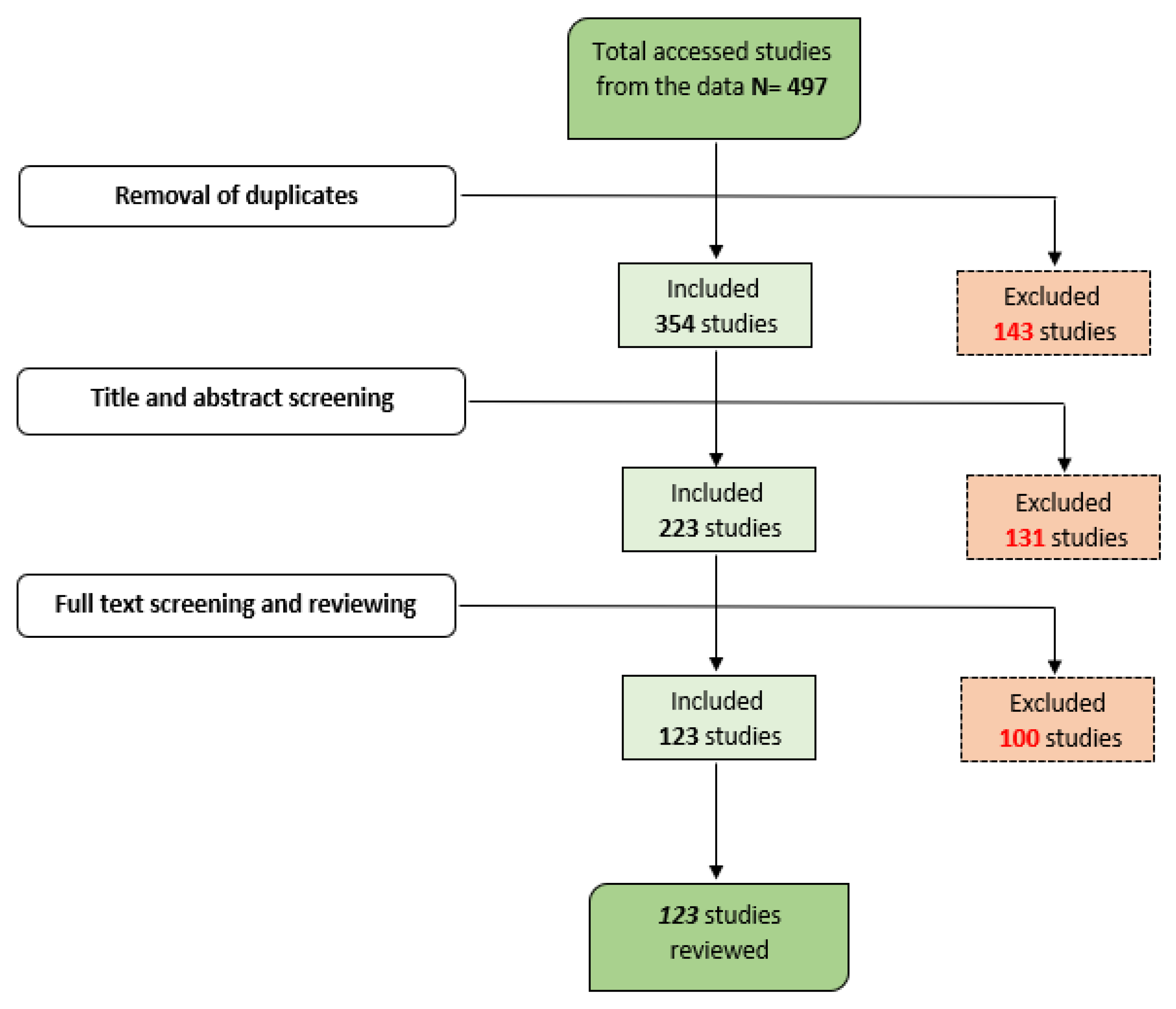
2.1. Systematic Review
2.2. Literature Selection Process
2.3. Review Analysis
3. Results
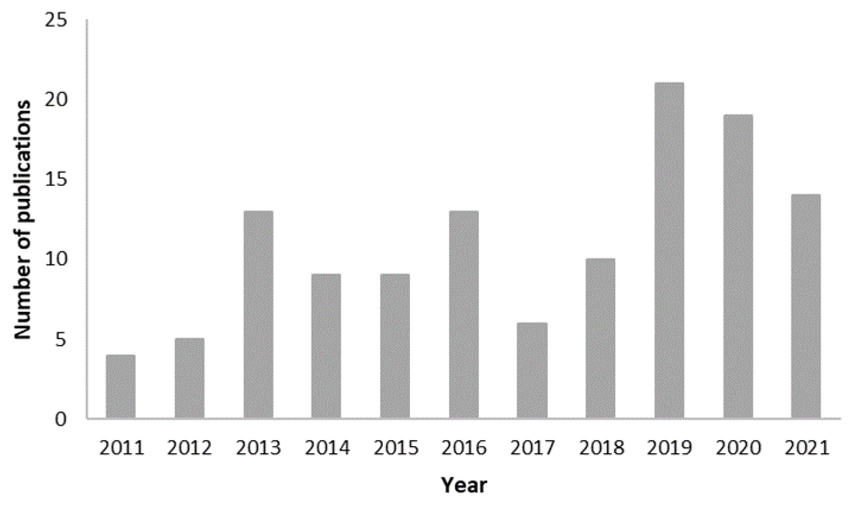
3.1. Temporal Scope
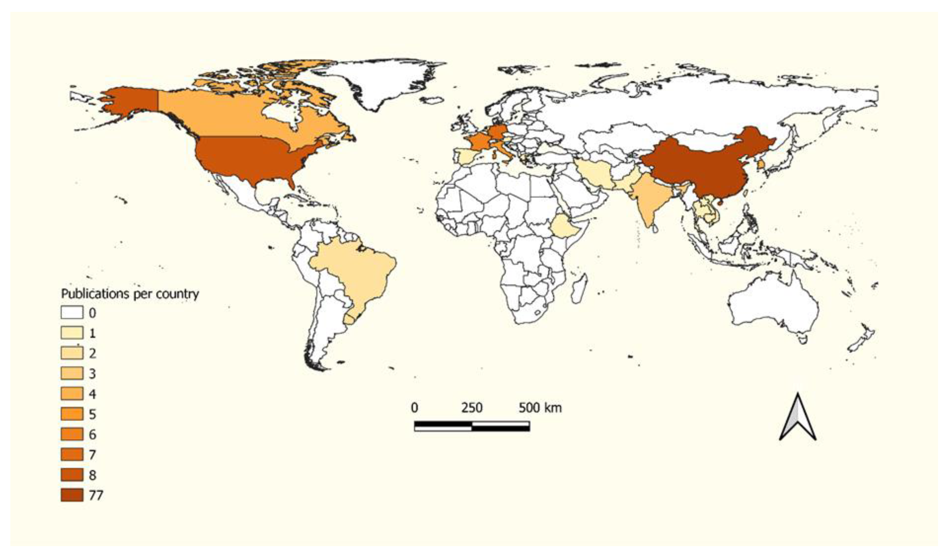
3.2. Geographical Distribution
3.3. Crop Models
3.4. Remote Sensing Datasets
3.5. Data Assimilation Methods and Application Scale
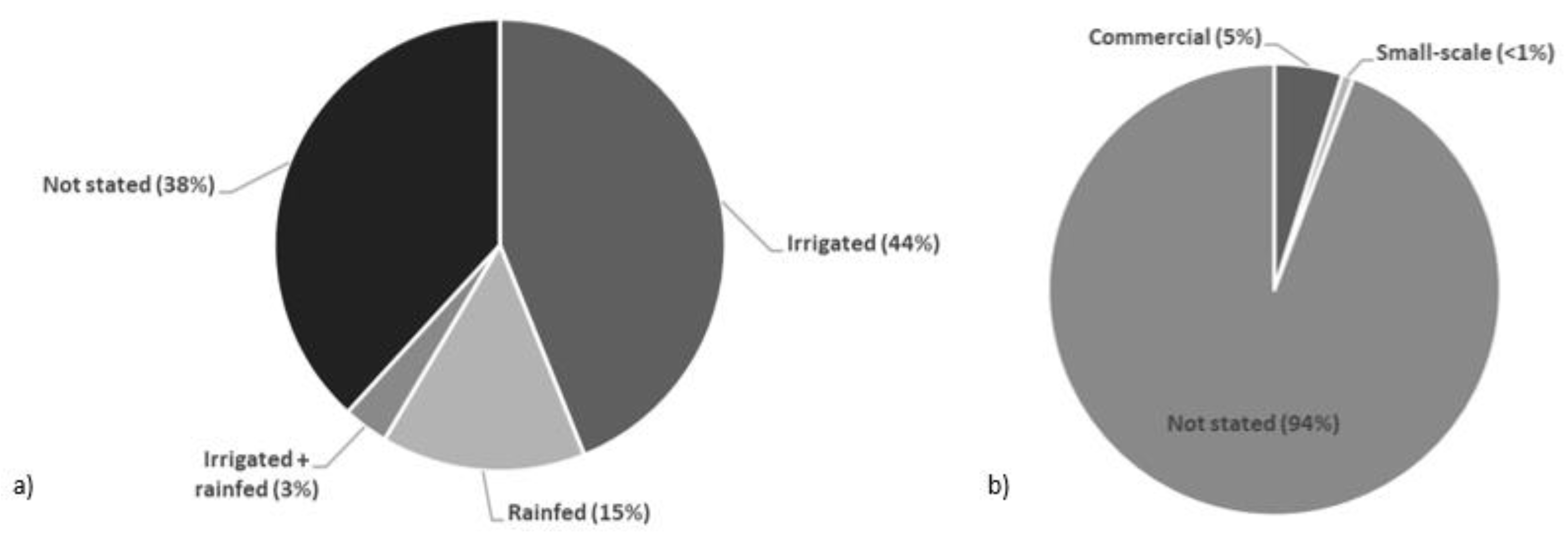
3.6. Types of Agricultural Cropping Systems
4. Discussion
4.1. Current Status of Data Assimilation in Remote Sensing and Crop Models
4.2. Complementary Advancement of Crop Models and Remote Sensing Datasets
4.3. Type of Data Assimilation Methods
4.4. Application of Data Assimilation in Small-Scale Agricultural Systems
4.5. Future Opportunities
Prospects of Data Assimilation Research in Africa
5. Conclusions
Author Contributions
Funding
Data Availability Statement
Conflicts of Interest
Appendix A

| Crop | CGM | RS Data | State Variable | Scale | Aim | Reference |
|---|---|---|---|---|---|---|
| Jujube | WOFOST | Landsat-8 | LAI | Field | Yield, AGB | [59] |
| Rice | STICS | SPOT-4, SPOT-5, Landsat-8 | LAI | Field | AGB, SD | [35] |
| Rice | STICS + PROSAIL | Sentinel-2 | LAI, SD | Field, regional | Yield | [66] |
| Wheat | DSSAT | Landsat-7, Landsat-8 | NDWI | Field, regional | Yield, SM | [64] |
| Wheat | SAFY | Sentinel-2, PlanetScope | LAI | Field | Yield | [89] |
| Rice | ORYZA | Sentinel-1 | LAI | Regional | Yield | [56] |
| Sugarcane | MOSICAS | SPOT-4, SPOT-5 | NDVI | Field | Yield | [60] |
| Sugarcane | MOSICAS | SPOT-4, SPOT-5 | FAPAR | Field | Yield | [19] |
| Sugarcane | SWAP-WOFOST | UAV | LAI, SM | Field | Yield | [53] |
| Wheat | WOFOST | SPOT-VGT | LAI, SD | Regional | Yield | [45] |
| Crop | Model | RS Data | State Variable | Assimilation Algorithm | Scale | Aim | Reference |
|---|---|---|---|---|---|---|---|
| Jujube | WOFOST | Landsat-8 | LAI | SUBPLEX | Field | Yield | [58] |
| Jujube | WOFOST | Landsat-8 | LAI | SCE | Field | Yield, AGB | [59] |
| Soybean | SAFY | Radarsat-2, Formosat-2, SPOT-4, SPOT-5 | LAI, AGB | Simplex | Field | Yield, AGB | [73] |
| Wheat | AquaCrop + PROSAIL | Huanjing-1, Landsat-8 | LAI, CC | Simplex | Field | Yield | [119] |
| Wheat | AquaCrop + PROSAIL | Huanjing-1, Landsat-8 | LAI, CC | Simplex | Field | Yield | [51] |
| Wheat | DSSAT | Landsat-8 | LAI, LNA | SCE, SA, DE | Regional | GPC | [118] |
| Rice | STICS + PROSAIL | Sentinel-2 | LAI, SD | Simplex | Field, regional | Yield | [66] |
| Wheat | DSSAT + PROSAIL | Field sensor | Reflectance, NDVI | VFSA | Field | LAI | [75] |
| Wheat | DSSAT + PROSAIL | Field sensor | Reflectance, NDVI | VFSA | Field | LAI | [104] |
| Rice | WARM + PROSAIL | Landsat-7, Landsat-8 | LAI | Simplex | Field | Yield | [136] |
| Wheat | WOFOST + PROSAIL | Landsat-8, MODIS | Reflectance | SCE | Field, regional | Yield | [80] |
| Wheat | SAFY + ESTARFM | Landsat-8, MODIS | GLAI | SCE | Field | AGB | [91] |
| Maize | DSSAT + MCRM | MODIS | LAI, EVI | GA | Regional | Yield | [88] |
| Wheat | WOFOST | MODIS | LAI | SCE | Field, regional | LAI, MD | [137] |
| Wheat | SAFY | Landsat-7, Landsat-8, Sentinel-2 | LAI | ULM | Field | Yield | [43] |
| Soybean | WOFOST | Sentinel-2 | LAI | SUBPLEX | Field | Yield | [7] |
| Wheat | SWAP-WOFOST | MODIS | LAI, ET | SCE | Field, regional | Yield | [63] |
| Wheat | SWAP-WOFOST | MODIS | LAI, ET | SCE | Field, regional | Yield | [16] |
| Wheat, Maize, Soybean | STICS | Landsat-7, SPOT-5 | LAI | Simplex | Field | Yield, AGB | [55] |
| Maize | STICS | Landsat-7, SPOT-5, CASI | LAI | Simplex | Regional | Yield, SWC | [105] |
| Rice | GRAMI | COMS GOCI, MODIS | LAI | POWELL, Quasi-Newton | Regional | ET, GPP | [138] |
| Rice | WOFOST | Landsat-8 | LAI | PSO | Regional | WRT | [93] |
| Wheat | AquaCrop | Field sensor | NDMI | PSO | Regional | Yield, AGB | [76] |
| Wheat | AquaCrop | Huanjing-1, MODIS | LAI, AGB, EVI, RVI, MTV12 | PSO | Regional | Yield, AGB, CC | [115] |
| Maize | AquaCrop | Field sensor | CC, AGB | PSO | Sub-field | Yield | [52] |
| Maize | DSSAT | RapidEye | AGB | SA | Field | Yield | [70] |
| Wheat | DSSAT | Field sensor | CNA | PSO | Regional | Yield, GPC | [81] |
| Wheat | DSSAT | Field sensor | LAI, CNA | PSO | Regional | Yield, GPC | [85] |
| Wheat | WOFOST | MODIS | LAI | SCE | Regional | Yield | [123] |
| Rice | SIMRIW | COSMO-SkyMed | LAI | Simplex | Regional | Yield | [116] |
| Sugarcane | MOSICAS | SPOT-4, SPOT-5 | FAPAR | SA | Field | Yield | [19] |
| Rice | GRAMI | COMS GOCI, RapidEye | LAI | POWELL, Quasi- Newton | Field, regional | Yield | [106] |
| Rice | GRAMI | COMS GOCI, RapidEye | LAI | POWELL, Quasi- Newton | Regional | Yield | [139] |
| Wheat | EPIC + PROSAIL | Sentinel-2 | LAI | Fmincon | Field, regional | Yield | [111] |
| Wheat | EPIC | MODIS | LAI | SCE | Regional | Yield, SD | [61] |
| Soybean | GRAMI | Field sensor | LAI | POWELL | Field | Yield | [101] |
| Wheat | AquaCrop + PROSAIL | Huanjing-1, Landsat-8 | LAI, CC | PSO | Field, regional | Yield | [84] |
| Rice | DSSAT | MODIS | LAI | PSO | Regional | Yield | [92] |
| Wheat | DSSAT + PROSAIL | Field sensor | LAI | PEST, GA | Field | Yield, CC, CNA | [120] |
| Wheat | WOFOST | MODIS. | LAI | POWELL, SCE | Field, regional | Yield | [33] |
| Sunflower | SUNFLOW | GEOSAT-1, Formosat-2, Landsat-8, Sentinel-2, SPOT-5 | LAI | LSE | Field | Yield | [36] |
| Wheat | AquaCrop | Sentinel-2 | CC | PSO | Field | Yield | [140] |
| Maize | MCWLA | GLASS, MODIS | LAI, VTCI | GA | Regional | Yield | [32] |
| Rice | RiceGrow | Field sensor, Huanjing-1 | LNA, LAI | PSO, SCE | Field, regional | Yield | [86] |
| Wheat | WOFOST + PROSAIL | MODIS | GAI | Simplex | Regional | Yield, AGB | [96] |
| Wheat | WOFOST + PROSAIL | GaoFen-1, Huanjing-1 | LAI | SCE | Field, regional | Yield | [117] |
| Wheat | WOFOST + PROSAIL | GaoFen-1, Huanjing-1 | LAI | SCE | Field, regional | Yield, SM | [97] |
| Wheat | SWAP-WOFOST | MODIS | LAI | SCE | Regional | Phenology | [98] |
| Wheat | SAFY | Field sensor | LAI | SCE | Field | LAI, AGB | [50] |
| Wheat | MCWLA | GLASS | LAI, SM, phenology | PSO | Regional | Yield | [68] |
| Wheat | SAFY | Field sensor | LAI | SCE | Field | Yield, ET AGB, SM | [90] |
| Rice | WOFOST | Huanjing-1 | LAI | PSO | Regional | WSO, WRT | [141] |
| Wheat | WOFOST | Huanjing-1, Landsat-8 | LAI | LSM | Regional | Yield | [142] |
| Wheat | DSSAT | ESACCI, MODIS | SM, LAI | SCE-UA | Field | Yield | [143] |
| Wheat | WOFOST | MODIS | LAI | SCE-UA | Regional | MD, anthesis | [62] |
| Wheat | WheatGrow + PROSAIL | HUANJING-1 | NDVI, RVI, SAVI, EVI, LAI, LAN | PSO | Regional | LAI, LNA, Yield | [79] |
| Maize | DSSAT | Field sensor | LAI | VFSA | Regional | LAI | [144] |
| Wheat | AquaCrop | Sentinel-2 | CC | PSO | Field | Yield | [37] |
| Wheat | WheatGrow + PROSAIL | Huanjing-1, SPOT-5, SPOT-6 | RVI, NDVI, SAVI, EVI | LUT | Regional | Yield, LAI, LNA | [78] |
| Rice | MCWLA | GLASS | LAI, phenology | PSO | Regional | Yield, phenology | [87] |
| Rice | WOFOST + PROSAIL | GaoFen-1 | FAPAR | PSO | Regional | FAPAR | [72] |
| Wheat | PROMET + SLC | Landsat-7, RapidEye | LAI | LUT | Field | Yield | [121] |
| Rice | STICS | SPOT-4, SPOT-5, Landsat-8 | LAI | Simplex | Field | AGB, SD | [35] |
| Soybean, maize | SAFY + STARFM | Landsat-8, MODIS | GLAI | SCE | Subfield | Yield, AGB, phenology | [49] |
| Wheat | WOFOST | Landsat-8, MODIS | LAI | SCE | Field, regional | Yield | [145] |
| Crop | Model | RS Dataset | State Variable | Assimilation Algorithm | Scale | Aim | Reference |
|---|---|---|---|---|---|---|---|
| Jujube | WOFOST | Landsat-8 | LAI | EnKF | Field | Yield | [58] |
| Wheat | WOFOST | MODIS | LAI | EnKF | Field, regional | Yield | [44] |
| Wheat | AquaCrop + PROSAIL | Huanjing-1, Landsat-8 | LAI, CC | EnKF | Field | Yield | [119] |
| Wheat | AquaCrop + PROSAIL | Huanjing-1, Landsat-8 | LAI, CC | EnKF | Field | Yield | [51] |
| Soybean | DSSAT | SMOS | SM | EnKF | Regional | LAI, GW | [41] |
| Wheat | MCWLA | Copernicus, GLASS, GLOBMAP | LAI | 4DVAR, En4DVAR | Regional | Yield | [22] |
| Wheat | MCWLA | GLASS | LAI | KF | Regional | Yield | [110] |
| Maize | WOFOST + PROSAIL | Huanjing-1 | LAI | EnKF | Field | Yield | [67] |
| Maize | WOFOST | Huanjing-1 | LAI | EnKF | Field, regional | SAN | [146] |
| Maize | WOFOST | Huanjing-1 | LAI | EnKF | Regional | SAN | [95] |
| Maize | WOFOST | UAV | LAI | EnKF | Regional | LAI | [113] |
| Maize | DSSAT | SMAP | SM | EnKF | Regional | Yield, IA | [107] |
| Wheat | WheatGrow + PROSAIL | Huanjing-1, SPOT6 | LAI | EnKF | Field, regional | LNA, Yield | [71] |
| Wheat | DSSAT + PROSAIL | Field sensor | Reflectance, NDVI | EnKF, 4DVAR | Field | LAI | [75] |
| Wheat | DSSAT + PROSAIL | Field sensor | Reflectance, NDVI | 4DVAR | Field | LAI | [104] |
| Wheat | WheatGrow | Landsat-5 | LAI, LNA | EnSRF, EnKF | Regional | Yield | [147] |
| Wheat | WOFOST + PROSAIL | Landsat-5, Landsat-8 | LAI | 4DVAR | Regional | Yield | [148] |
| Wheat | WOFOST | Landsat-5, MODIS | LAI | EnKF, KF | Regional | Yield | [10] |
| Wheat | WOFOST | Landsat-8, MODIS | LAI | 4DVAR | Field, regional | Yield | [145] |
| Wheat | WOFOST + PROSAIL | Landsat-8, MODIS | Reflectance | 4DVAR | Field, regional | Yield | [80] |
| Maize | DSSAT | AMSR-E | SM | EnKF | Field, regional | Yield | [15] |
| Wheat | WOFOST + CASA | Sentinel-2 | LAI, FAPAR | EnKF | Field | Yield, NPP | [46] |
| Wheat | DSSAT + ACRM | Huanjing-1 | LAI | PF | Field, regional | Yield | [102] |
| Wheat | DSSAT + ACRM | Huanjing-1 | LAI | POD4DVar | Field, regional | Yield | [149] |
| Maize | SAFY | Landsat-5, Landsat-7, Landsat-8 | LAI | EnKF | Field | Yield, AGB | [34] |
| Wheat | DSSAT + PROSAIL | Field sensor | LAI | EnKF | Field | NDVI | [47] |
| Maize | WOFOST | Landsat-7 | LAI | EnKF | Regional | Yield | [103] |
| Wheat | DSSAT + PROSAIL | GaoFen-1, Huanjing-1, Landsat-8 | LAI | PF, POD4Dvar | Field | Yield | [124] |
| Wheat | DSSAT + ACRM | Huanjing-1 | LAI | EnKF | Field, regional | Yield, phenology | [150] |
| Wheat | WOFOST | MODIS | LAI | PF | Field, regional | Yield | [31] |
| Soybean | DSSAT + MIMICS | MODIS | SM, LAI, AGB | EnKF | Regional | LAI, AGB | [151] |
| Maize | DSSAT | AMSR-E, SMOS | SM | EnKF | Field | Yield | [77] |
| Wheat | DSSAT | Sentinel-2 | LAI, SM | EnKF | Field, regional | Yield | [48] |
| Wheat | DSSAT | Sentinel-2 | LAI | EnKF | Field, regional | Yield | [83] |
| Wheat | WOFOST + ACRM | Huanjing-1 | NDVI | EnKF | Regional | Yield | [152] |
| Maize | APSIM + PROSAIL | RapidEye | CSF | PF | Field | AGB | [69] |
| Maize | DSSAT + ALEXI | RDSMP | SM | EnKF | Regional | Yield | [94] |
| Wheat, barley | SWAP-WOFOST | MODIS | LAI | KF | Regional | Yield, AGB | [57] |
| Wheat | WOFOST + PROSAIL | Sentinel-1, Sentinel-2 | LAI, SM | EnKF | Field, regional | Yield | [82] |
| Maize | SAFY | UAV | LAI | EnKF | Field | Yield | [14] |
| Sugarcane | SWAP-WOFOST | UAV | LAI, SM | EnKF | Field | Yield | [53] |
| Maize | SAFY | Sentinel-2 | LAI | EnKF | Field | Yield, AGB | [40] |
| Wheat | SIMPLACE- LINTUL5 + PROSAIL | Sentinel-2 | LAI | EnKF, WM | Sub-field | AGB | [65] |
| Wheat | SIMPLACE- LINTUL5 + PROSAIL | Sentinel-2 | LAI | EnKF | Sub-field | AGB, water stress | [38] |
| Sunflower | SUNFLOW | GEOSAT-1, Formosat-2, Landsat-8, Sentinel-2, SPOT-5 | LAI | EnKF | Field | Yield | [36] |
| Wheat | AquaCrop | Sentinel-2 | CC | EnKF | Field | Yield | [140] |
| Wheat | AquaCrop | VENµS | fvc | DREAM(KZS) | Regional | Yield, AGB | [39] |
| Maize | WOFOST | Field sensor | LAI | EnKF | Regional | Yield, GPP | [153] |
| Wheat | DSSAT | MODIS | VTCI | 4DVAR | Field, regional | Yield | [154] |
| Wheat | WOFOST | MODIS | LAI | EnKF | Field, regional | Yield | [155] |
| Rice | WOFOST | Huanjing-1 | LAI | EnKF | Regional | Yield | [32] |
| Wheat | AquaCrop | Sentinel-2 | CC | KF | Field | Yield | [37] |
| Wheat | WOFOST + PROSAIL | MODIS | GLAI | EnKF | Regional | Yield, AGB | [96] |
| Wheat | WOFOST | MODIS | LAI | EnKF | Regional | Yield | [156] |
| Wheat | SAFY | Field sensor | LAI | EnKF | Field | Yield, SM, AGB, ET | [90] |
| Wheat | WOFOST + PROSAIL | GaoFen-1, Huanjing-1 | LAI | EnKF, EnSRF, VW-4DEnSRF | Regional | Yield, SM | [97] |
| Sugarcane | SWAP-WOFOST | UAV | Phenology | IES | Field | Yield | [54] |
| Wheat | AquaCrop | UAV | CC | PF | Field | CC, cdc | [74] |
| Wheat | WOFOST | Sentinel-2 | SM | EnKF | Regional | Yield | [72] |
| Maize | WOFOST | MODIS | LAI | EnKF | Regional | Yield, GD | [142] |
| Maize, wheat | WOFOST | MODIS | LAI | EnKF | Field | LAI | [100] |
| Wheat | WOFOST | Sentinel-1, Sentinel-2 | SM | EnKF | Regional | Yield | [157] |
References
- Morton, J.F. The impact of climate change on smallholder and subsistence agriculture. Proc. Natl. Acad. Sci. USA 2007, 104, 19680–19685. [Google Scholar] [CrossRef] [PubMed]
- Williams, P.A.; Crespo, O.; Abu, M.; Simpson, N.P. A systematic review of how vulnerability of smallholder agricultural systems to changing climate is assessed in Africa. Environ. Res. Lett. 2018, 13, 103004. [Google Scholar] [CrossRef]
- Choruma, D.; Balkovic, J.; Odume, O.N. Calibration and Validation of the EPIC Model for Maize Production in the Eastern Cape, South Africa. Agronomy 2019, 9, 494. [Google Scholar] [CrossRef]
- He, M.; Kimball, J.; Maneta, M.; Maxwell, B.; Moreno, A.; Beguería, S.; Wu, X. Regional Crop Gross Primary Productivity and Yield Estimation Using Fused Landsat-MODIS Data. Remote Sens. 2018, 10, 372. [Google Scholar] [CrossRef]
- Kephe, P.N.; Ayisi, K.K.; Petja, B.M. Challenges and opportunities in crop simulation modelling under seasonal and projected climate change scenarios for crop production in South Africa. Agric. Food Secur. 2021, 10, 10. [Google Scholar] [CrossRef]
- Nagamani, K.; Nethaji Mariappan, V.E. Remote Sensing, GIS and Crop Simulation Models—A Review. Int. J. Curr. Res. Biosci. Plant Biol. 2017, 4, 80–92. [Google Scholar] [CrossRef]
- Gaso, D.V.; de Wit, A.; Berger, A.G.; Kooistra, L. Predicting within-field soybean yield variability by coupling Sentinel-2 leaf area index with a crop growth model. Agric. For. Meteorol. 2021, 308–309, 108553. [Google Scholar] [CrossRef]
- Enenkel, M.; Reimer, C.; Dorigo, W.; Wagner, W.; Pfeil, I.; Parinussa, R.; De Jeu, R. Combining satellite observations to develop a global soil moisture product for near-real-time applications. Hydrol. Earth Syst. Sci. 2016, 20, 4191–4208. [Google Scholar] [CrossRef]
- Marin, F.; Jones, J.W.; Boote, K.J. A Stochastic Method for Crop Models: Including Uncertainty in a Sugarcane Model. Agron. J. 2017, 109, 483–495. [Google Scholar] [CrossRef]
- Huang, J.X.; Sedano, F.; Huang, Y.B.; Ma, H.Y.; Li, X.L.; Liang, S.L.; Tian, L.Y.; Zhang, X.D.; Fan, J.L.; Wu, W.B. Assimilating a synthetic Kalman filter leaf area index series into the WOFOST model to improve regional winter wheat yield estimation. Agric. For. Meteorol. 2016, 216, 188–202. [Google Scholar] [CrossRef]
- Fang, H.L.; Liang, S.L.; Hoogenboom, G.; Teasdale, J.; Cavigelli, M. Corn-yield estimation through assimilation of remotely sensed data into the CSM-CERES-Maize model. Int. J. Remote Sens. 2008, 29, 3011–3032. [Google Scholar] [CrossRef]
- Yao, F.; Tang, Y.; Wang, P.; Zhang, J. Estimation of maize yield by using a process-based model and remote sensing data in the Northeast China Plain. Phys. Chem. Earth Parts A/B/C 2015, 87–88, 142–152. [Google Scholar] [CrossRef]
- Yuping, M.; Shili, W.; Li, Z.; Yingyu, H.; Liwei, Z.; Yanbo, H.; Futang, W. Monitoring winter wheat growth in North China by combining a crop model and remote sensing data. Int. J. Appl. Earth Obs. Geoinf. 2008, 10, 426–437. [Google Scholar] [CrossRef]
- Peng, X.S.; Han, W.T.; Ao, J.Y.; Wang, Y. Assimilation of LAI Derived from UAV Multispectral Data into the SAFY Model to Estimate Maize Yield. Remote Sens. 2021, 13, 17. [Google Scholar] [CrossRef]
- Ines, A.V.M.; Das, N.N.; Hansen, J.W.; Njoku, E.G. Assimilation of remotely sensed soil moisture and vegetation with a crop simulation model for maize yield prediction. Remote Sens. Environ. 2013, 138, 149–164. [Google Scholar] [CrossRef]
- Huang, J.X.; Ma, H.Y.; Su, W.; Zhang, X.D.; Huang, Y.B.; Fan, J.L.; Wu, W.B. Jointly Assimilating MODIS LAI and ET Products Into the SWAP Model for Winter Wheat Yield Estimation. IEEE J. Sel. Top. Appl. Earth Obs. Remote Sens. 2015, 8, 4060–4071. [Google Scholar] [CrossRef]
- Camino, C.; González-Dugo, V.; Hernández, P.; Sillero, J.C.; Zarco-Tejada, P.J. Improved nitrogen retrievals with airborne-derived fluorescence and plant traits quantified from VNIR-SWIR hyperspectral imagery in the context of precision agriculture. Int. J. Appl. Earth Obs. Geoinf. 2018, 70, 105–117. [Google Scholar] [CrossRef]
- Clevers, J.; Kooistra, L.; van den Brande, M. Using Sentinel-2 Data for Retrieving LAI and Leaf and Canopy Chlorophyll Content of a Potato Crop. Remote Sens. 2017, 9, 405. [Google Scholar] [CrossRef]
- Morel, J.; Begue, A.; Todoroff, P.; Martine, J.-F.; Lebourgeois, V.; Petit, M. Coupling a sugarcane crop model with the remotely sensed time series of fIPAR to optimise the yield estimation. Eur. J. Agron. 2014, 61, 60–68. [Google Scholar] [CrossRef]
- Mishra, V.; Cruise, J.; Mecikalski, J.; Hain, C.; Anderson, M. A Remote-Sensing Driven Tool for Estimating Crop Stress and Yields. Remote Sens. 2013, 5, 3331–3356. [Google Scholar] [CrossRef]
- Battude, M.; Al Bitar, A.; Morin, D.; Cros, J.; Huc, M.; Marais Sicre, C.; Le Dantec, V.; Demarez, V. Estimating maize biomass and yield over large areas using high spatial and temporal resolution Sentinel-2 like remote sensing data. Remote Sens. Environ. 2016, 184, 668–681. [Google Scholar] [CrossRef]
- Chen, Y.; Tao, F.L. Improving the practicability of remote sensing data-assimilation-based crop yield estimations over a large area using a spatial assimilation algorithm and ensemble assimilation strategies. Agric. For. Meteorol. 2020, 291, 14. [Google Scholar] [CrossRef]
- Huang, J.X.; Gomez-Dans, J.L.; Huang, H.; Ma, H.Y.; Wu, Q.L.; Lewis, P.E.; Liang, S.L.; Chen, Z.X.; Xue, J.H.; Wu, Y.T.; et al. Assimilation of remote sensing into crop growth models: Current status and perspectives. Agric. For. Meteorol. 2019, 276, 16. [Google Scholar] [CrossRef]
- Jin, X.L.; Kumar, L.; Li, Z.H.; Feng, H.K.; Xu, X.G.; Yang, G.J.; Wang, J.H. A review of data assimilation of remote sensing and crop models. Eur. J. Agron. 2018, 92, 141–152. [Google Scholar] [CrossRef]
- Kasampalis, D.A.; Alexandridis, T.K.; Deva, C.; Challinor, A.; Moshou, D.; Zalidis, G. Contribution of Remote Sensing on Crop Models: A Review. J. Imaging 2018, 4, 19. [Google Scholar] [CrossRef]
- Sun, P.; Wu, Y.; Xiao, J.; Hui, J.; Hu, J.; Zhao, F.; Qiu, L.; Liu, S. Remote sensing and modeling fusion for investigating the ecosystem water-carbon coupling processes. Sci. Total Environ. 2019, 697, 134064. [Google Scholar] [CrossRef]
- Livoreil, B.; Glanville, J.; Haddaway, N.R.; Bayliss, H.; Bethel, A.; de Lachapelle, F.F.; Robalino, S.; Savilaakso, S.; Zhou, W.; Petrokofsky, G.; et al. Systematic searching for environmental evidence using multiple tools and sources. Environ. Evid. 2017, 6, 23. [Google Scholar] [CrossRef]
- Onyango, C.M.; Nyaga, J.M.; Wetterlind, J.; Soderstrom, M.; Piikki, K. Precision Agriculture for Resource Use Efficiency in Smallholder Farming Systems in Sub-Saharan Africa: A Systematic Review. Sustainability 2021, 13, 1158. [Google Scholar] [CrossRef]
- Spires, M.; Shackleton, S.; Cundill, G. Barriers to implementing planned community-based adaptation in developing countries: A systematic literature review. Clim. Dev. 2014, 6, 277–287. [Google Scholar] [CrossRef]
- Barnett, A.; Blas, E.; Whiteside, A. AIDS briefs: Subsistence agriculture. In USAID Health and Human Resources Analysis and Research for Africa Project; World Health Organization: Washington, DC, USA, 1997. [Google Scholar]
- Liu, J.; Huang, J.; Tian, L.; Su, W. Particle filter-based assimilation algorithm for improving regional winter wheat yield estimation. Sens. Lett. 2014, 12, 763–769. [Google Scholar] [CrossRef]
- Wang, L.; Wang, P.; Liang, S.; Zhu, Y.; Khan, J.; Fang, S. Monitoring maize growth on the North China Plain using a hybrid genetic algorithm-based back-propagation neural network model. Comput. Electron. Agric. 2020, 170, 12. [Google Scholar] [CrossRef]
- Tian, L.Y.; Li, Z.X.; Huang, J.X.; Wang, L.M.; Su, W.; Zhang, C.; Liu, J.M. Comparison of Two Optimization Algorithms for Estimating Regional Winter Wheat Yield by Integrating MODIS Leaf Area Index and World Food Studies Model. Sens. Lett. 2013, 11, 1261–1268. [Google Scholar] [CrossRef]
- Kang, Y.H.; Ozdogan, M. Field-level crop yield mapping with Landsat using a hierarchical data assimilation approach. Remote Sens. Environ. 2019, 228, 144–163. [Google Scholar] [CrossRef]
- Courault, D.; Ruget, F.; Talab-ou-Ali, H.; Hagolle, O.; Delmotte, S.; Barbier, J.-M.; Boschetti, M.; Mouret, J.-C. Combining crop model and remote sensing data at high resolution for the assessment of rice agricultural practices in the South-Eastern France (Take 5 experiment SPOT4-SPOT5). In Proceedings of the Living Planet Symposium, Prague, Czech Republic, 9–13 May 2016; p. 171. [Google Scholar]
- Trepos, R.; Champolivier, L.; Dejoux, J.F.; Al Bitar, A.; Casadebaig, P.; Debaeke, P. Forecasting Sunflower Grain Yield by Assimilating Leaf Area Index into a Crop Model. Remote Sens. 2020, 12, 23. [Google Scholar] [CrossRef]
- Wagner, M.P.; Taravat, A.; Oppelt, N. Particle swarm optimization for assimilation of remote sensing data in dynamic crop models. In Remote Sensing for Agriculture, Ecosystems, and Hydrology XXI; SPIE: Bellingham, WA, USA, 2019; pp. 174–183. [Google Scholar]
- Tewes, A.; Montzka, C.; Nolte, M.; Krauss, G.; Hoffmann, H.; Gaiser, T. Assimilation of Sentinel-2 Estimated LAI into a Crop Model: Influence of Timing and Frequency of Acquisitions on Simulation of Water Stress and Biomass Production of Winter Wheat. Agronomy 2020, 10, 22. [Google Scholar] [CrossRef]
- Upreti, D.; Pignatti, S.; Pascucci, S.; Tolomio, M.; Huang, W.J.; Casa, R. Bayesian Calibration of the Aquacrop-OS Model for Durum Wheat by Assimilation of Canopy Cover Retrieved from VEN mu S Satellite Data. Remote Sens. 2020, 12, 23. [Google Scholar] [CrossRef]
- Silvestro, P.C.; Casa, R.; Hanus, J.; Koetz, B.; Rascher, U.; Schuettemeyer, D.; Siegmann, B.; Skokovic, D.; Sobrino, J.; Tudoroiu, M. Synergistic Use of Multispectral Data and Crop Growth Modelling for Spatial and Temporal Evapotranspiration Estimations. Remote Sens. 2021, 13, 25. [Google Scholar] [CrossRef]
- Chakrabarti, S.; Bongiovanni, T.; Judge, J.; Zotarelli, L.; Bayer, C. Assimilation of SMOS Soil Moisture for Quantifying Drought Impacts on Crop Yield in Agricultural Regions. IEEE J. Sel. Top. Appl. Earth Obs. Remote Sens. 2014, 7, 3867–3879. [Google Scholar] [CrossRef]
- Liu, F.; Liu, X.N.; Wu, L.; Xu, Z.; Gong, L. Optimizing the Temporal Scale in the Assimilation of Remote Sensing and WOFOST Model for Dynamically Monitoring Heavy Metal Stress in Rice. IEEE J. Sel. Top. Appl. Earth Obs. Remote Sens. 2016, 9, 1685–1695. [Google Scholar] [CrossRef]
- Gaso, D.V.; Berger, A.G.; Ciganda, V.S. Predicting wheat grain yield and spatial variability at field scale using a simple regression or a crop model in conjunction with Landsat images. Comput. Electron. Agric. 2019, 159, 75–83. [Google Scholar] [CrossRef]
- Beyene, A.N.; Zeng, H.; Wu, B.; Zhu, L.; Gebremicael, T.G.; Zhang, M.; Bezabh, T. Coupling remote sensing and crop growth model to estimate national wheat yield in Ethiopia. Big Earth Data 2021, 6, 18–35. [Google Scholar] [CrossRef]
- Tripathy, R.; Chaudhari, K.N.; Mukherjee, J.; Ray, S.S.; Patel, N.K.; Panigrahy, S.; Parihar, J.S. Forecasting wheat yield in Punjab state of India by combining crop simulation model WOFOST and remotely sensed inputs. Remote Sens. Lett. 2013, 4, 19–28. [Google Scholar] [CrossRef]
- Ji, F.; Meng, J.; Cheng, Z.; Fang, H.; Wang, Y. Crop Yield Estimation at Field Scales by Assimilating Time Series of Sentinel-2 Data Into a Modified CASA-WOFOST Coupled Model. IEEE Trans. Geosci. Remote Sens. 2021, 60, 1–14. [Google Scholar] [CrossRef]
- Li, R.; Li, C.-J.; Dong, Y.-Y.; Liu, F.; Wang, J.-H.; Yang, X.-D.; Pan, Y.-C. Assimilation of Remote Sensing and Crop Model for LAI Estimation Based on Ensemble Kaiman Filter. Agric. Sci. China 2011, 10, 1595–1602. [Google Scholar] [CrossRef]
- Liu, Z.C.; Xu, Z.J.; Bi, R.; Wang, C.; He, P.; Jing, Y.D.; Yang, W.D. Estimation of Winter Wheat Yield in Arid and Semiarid Regions Based on Assimilated Multi-Source Sentinel Data and the CERES-Wheat Model. Sensors 2021, 21, 16. [Google Scholar] [CrossRef]
- Liao, C.H.; Wang, J.F.; Dong, T.F.; Shang, J.L.; Liu, J.G.; Song, Y. Using spatio-temporal fusion of Landsat-8 and MODIS data to derive phenology, biomass and yield estimates for corn and soybean. Sci. Total Environ. 2019, 650, 1707–1721. [Google Scholar] [CrossRef]
- Zhang, C.; Liu, J.; Dong, T.; Pattey, E.; Shang, J.; Tang, M.; Cai, H.; Saddique, Q. Coupling Hyperspectral Remote Sensing Data with a Crop Model to Study Winter Wheat Water Demand. Remote Sens. 2019, 11, 19. [Google Scholar] [CrossRef]
- Casa, R.; Silvestro, P.C.; Yang, H.; Pignatti, S.; Pascucci, S.; Yang, G. Assimilation of remotely sensed canopy variables into crop models for an assessment of drought-related yield losses: A comparison of models of different complexity. In Proceedings of the 2016 IEEE International Geoscience and Remote Sensing Symposium (IGARSS), Beijing, China, 10–15 July 2016; IEEE: Piscataway, NJ, USA, 2016; pp. 5925–5928. [Google Scholar]
- Jin, X.L.; Li, Z.H.; Feng, H.K.; Ren, Z.B.; Li, S.K. Estimation of maize yield by assimilating biomass and canopy cover derived from hyperspectral data into the AquaCrop model. Agric. Water Manag. 2020, 227, 10. [Google Scholar] [CrossRef]
- Shi, L.; Hu, S.; Zha, Y. Estimation of Sugarcane Yield by Assimilating UAV and Ground Measurements Via Ensemble Kalman Filter. In Proceedings of the IGARSS 2018-2018 IEEE International Geoscience and Remote Sensing Symposium, Valencia, Spain, 22–27 July 2018; pp. 8816–8819. [Google Scholar] [CrossRef]
- Yu, D.; Zha, Y.; Shi, L.; Jin, X.; Hu, S.; Yang, Q.; Huang, K.; Zeng, W. Improvement of sugarcane yield estimation by assimilating UAV-derived plant height observations. Eur. J. Agron. 2020, 121, 16. [Google Scholar] [CrossRef]
- Jégo, G.; Pattey, E.; Liu, J. Using Leaf Area Index, retrieved from optical imagery, in the STICS crop model for predicting yield and biomass of field crops. Field Crops Res. 2012, 131, 63–74. [Google Scholar] [CrossRef]
- Mohite, J.; Sawant, S.; Sakkan, M.; Shivalli, P.; Kodimela, K.; Pappula, S. Spatialization of rice crop yield using Sentinel-1 SAR and Oryza Crop Growth Simulation Model. In Proceedings of the 2019 8th International Conference on Agro-Geoinformatics (Agro-Geoinformatics), Istanbul, Turkey, 16–19 July 2019; pp. 1–6. [Google Scholar] [CrossRef]
- Mokhtari, A.; Noory, H.; Vazifedoust, M. Improving crop yield estimation by assimilating LAI and inputting satellite-based surface incoming solar radiation into SWAP model. Agric. For. Meteorol. 2018, 250, 159–170. [Google Scholar] [CrossRef]
- Bai, T.C.; Wang, S.G.; Meng, W.B.; Zhang, N.N.; Wang, T.; Chen, Y.Q.; Mercatoris, B. Assimilation of Remotely-Sensed LAI into WOFOST Model with the SUBPLEX Algorithm for Improving the Field-Scale Jujube Yield Forecasts. Remote Sens. 2019, 11, 20. [Google Scholar] [CrossRef]
- Bai, T.C.; Zhang, N.N.; Mercatoris, B.; Chen, Y.Q. Improving Jujube Fruit Tree Yield Estimation at the Field Scale by Assimilating a Single Landsat Remotely-Sensed LAI into the WOFOST Model. Remote Sens. 2019, 11, 22. [Google Scholar] [CrossRef]
- Morel, J.; Martiné, J.; Bégué, A.; Todoroff, P.; Petit, M. A comparison of two coupling methods for improving a sugarcane model yield estimation with a NDVI-derived variable. Proc. SPIE 2012, 8531, 85310E. [Google Scholar] [CrossRef]
- Ren, J.; Chen, Z.; Tang, H.; Yu, F.; Huang, Q. Simulation of regional winter wheat yield by combining epic model and remotely sensed LAI based on global optimization algorithm. In Proceedings of the 2011 IEEE International Geoscience and Remote Sensing Symposium, Vancouver, BC, Canada, 24–29 July 2011; pp. 4058–4061. [Google Scholar] [CrossRef]
- Zhuo, W.; Huang, J.; Gao, X.; Ma, H.; Huang, H.; Su, W.; Meng, J.; Li, Y.; Chen, H.; Yin, D. Prediction of Winter Wheat Maturity Dates through Assimilating Remotely Sensed Leaf Area Index into Crop Growth Model. Remote Sens. 2020, 12, 19. [Google Scholar] [CrossRef]
- Huang, J.; Ma, H.; Liu, J.; Zhu, D.; Zhang, X. Regional winter wheat yield estimation by assimilating MODIS ET and LAI products into SWAP model. In Proceedings of the 2013 Second International Conference on Agro-Geoinformatics (Agro-Geoinformatics), Fairfax, VA, USA, 12–16 August 2013; IEEE: Piscataway, NJ, USA, 2013; pp. 454–459. [Google Scholar]
- Fahad, M.; Ahmad, I.; Rehman, M.; Waqas, M.M.; Gul, F. Regional Wheat Yield Estimation by Integration of Remotely Sensed Soil Moisture into a Crop Model. Can. J. Remote Sens. 2019, 45, 770–781. [Google Scholar] [CrossRef]
- Tewes, A.; Hoffmann, H.; Nolte, M.; Krauss, G.; Schafer, F.; Kerkhoff, C.; Gaiser, T. How Do Methods Assimilating Sentinel-2-Derived LAI Combined with Two Different Sources of Soil Input Data Affect the Crop Model-Based Estimation of Wheat Biomass at Sub-Field Level? Remote Sens. 2020, 12, 21. [Google Scholar] [CrossRef]
- Courault, D.; Hossard, L.; Demarez, V.; Dechatre, H.; Irfan, K.; Baghdadi, N.; Flamain, F.; Ruget, F. STICS crop model and Sentinel-2 images for monitoring rice growth and yield in the Camargue region. Agron. Sustain. Dev. 2021, 41, 49. [Google Scholar] [CrossRef]
- Cheng, Z.Q.; Meng, J.H.; Wang, Y.M. Improving Spring Maize Yield Estimation at Field Scale by Assimilating Time-Series HJ-1 CCD Data into the WOFOST Model Using a New Method with Fast Algorithms. Remote Sens. 2016, 8, 22. [Google Scholar] [CrossRef]
- Zhang, Z.; Li, Z.; Chen, Y.; Zhang, L.; Tao, F. Improving regional wheat yields estimations by multi-step-assimilating of a crop model with multi-source data. Agric. For. Meteorol. 2020, 290, 13. [Google Scholar] [CrossRef]
- Machwitz, M.; Giustarini, L.; Bossung, C.; Frantz, D.; Schlerf, M.; Lilienthal, H.; Wandera, L.; Matgen, P.; Hoffmann, L.; Udelhoven, T. Enhanced biomass prediction by assimilating satellite data into a crop growth model. Environ. Model. Softw. 2014, 62, 437–453. [Google Scholar] [CrossRef]
- Joshi, V.R.; Thorp, K.R.; Coulter, J.A.; Johnson, G.A.; Porter, P.M.; Strock, J.S.; Garcia, A.G.Y. Improving Site-Specific Maize Yield Estimation by Integrating Satellite Multispectral Data into a Crop Model. Agronomy 2019, 9, 18. [Google Scholar] [CrossRef]
- Guo, C.L.; Tang, Y.N.; Lu, J.S.; Zhu, Y.; Cao, W.X.; Cheng, T.; Zhang, L.; Tian, Y.C. Predicting wheat productivity: Integrating time series of vegetation indices into crop modeling via sequential assimilation. Agric. For. Meteorol. 2019, 272, 69–80. [Google Scholar] [CrossRef]
- Zhou, G.; Liu, M.; Liu, X.; Li, J. Combination of Crop Growth Model and Radiation Transfer Model with Remote Sensing Data Assimilation for Fapar Estimation. In Proceedings of the IGARSS 2018-2018 IEEE International Geoscience and Remote Sensing Symposium, Valencia, Spain, 22–27 July 2018; pp. 1882–1885. [Google Scholar] [CrossRef]
- Betbeder, J.; Fieuzal, R.; Baup, F. Assimilation of LAI and Dry Biomass Data From Optical and SAR Images Into an Agro-Meteorological Model to Estimate Soybean Yield. IEEE J. Sel. Top. Appl. Earth Obs. Remote Sens. 2016, 9, 2540–2553. [Google Scholar] [CrossRef]
- Zhang, T.; Su, J.; Liu, C.; Chen, W.-H. State and parameter estimation of the AquaCrop model for winter wheat using sensitivity informed particle filter. Comput. Electron. Agric. 2021, 180, 11. [Google Scholar] [CrossRef]
- Dong, Y.Y.; Wang, J.H.; Li, C.J.; Yang, G.J.; Wang, Q.; Liu, F.; Zhao, J.L.; Wang, H.F.; Huang, W.J. Comparison and Analysis of Data Assimilation Algorithms for Predicting the Leaf Area Index of Crop Canopies. IEEE J. Sel. Top. Appl. Earth Obs. Remote Sens. 2013, 6, 188–201. [Google Scholar] [CrossRef]
- Jin, X.L.; Kumar, L.; Li, Z.H.; Xu, X.G.; Yang, G.J.; Wang, J.H. Estimation of Winter Wheat Biomass and Yield by Combining the AquaCrop Model and Field Hyperspectral Data. Remote Sens. 2016, 8, 15. [Google Scholar] [CrossRef]
- Liu, D.; Mishra, A.K.; Yu, Z.B. Evaluation of hydroclimatic variables for maize yield estimation using crop model and remotely sensed data assimilation. Stoch. Environ. Res. Risk Assess. 2019, 33, 1283–1295. [Google Scholar] [CrossRef]
- Zhang, L.; Guo, C.L.; Zhao, L.Y.; Zhu, Y.; Cao, W.X.; Tian, Y.C.; Cheng, T.; Wang, X. Estimating wheat yield by integrating the WheatGrow and PROSAIL models. Field Crops Res. 2016, 192, 55–66. [Google Scholar] [CrossRef]
- Guo, C.L.; Zhang, L.; Zhou, X.; Zhu, Y.; Cao, W.X.; Qiu, X.L.; Cheng, T.; Tian, Y.C. Integrating remote sensing information with crop model to monitor wheat growth and yield based on simulation zone partitioning. Precis. Agric. 2018, 19, 55–78. [Google Scholar] [CrossRef]
- Huang, J.X.; Ma, H.Y.; Sedano, F.; Lewis, P.; Liang, S.; Wu, Q.L.; Su, W.; Zhang, X.D.; Zhu, D.H. Evaluation of regional estimates of winter wheat yield by assimilating three remotely sensed reflectance datasets into the coupled WOFOST-PROSAIL model. Eur. J. Agron. 2019, 102, 1–13. [Google Scholar] [CrossRef]
- Li, Z.H.; Jin, X.L.; Zhao, C.J.; Wang, J.H.; Xu, X.G.; Yang, G.J.; Li, C.J.; Shen, J.X. Estimating wheat yield and quality by coupling the DSSAT-CERES model and proximal remote sensing. Eur. J. Agron. 2015, 71, 53–62. [Google Scholar] [CrossRef]
- Pan, H.Z.; Chen, Z.X.; de Wit, A.; Ren, J.Q. Joint Assimilation of Leaf Area Index and Soil Moisture from Sentinel-1 and Sentinel-2 Data into the WOFOST Model for Winter Wheat Yield Estimation. Sensors 2019, 19, 17. [Google Scholar] [CrossRef]
- Liu, Z.C.; Chao, W.; Bi, R.T.; Zhu, H.F.; He, P.; Jing, Y.D.; Yang, W.D. Winter wheat yield estimation based on assimilated Sentinel-2 images with the CERES-Wheat model. J. Integr. Agric. 2021, 20, 1958–1968. [Google Scholar] [CrossRef]
- Silvestro, P.C.; Pignatti, S.; Pascucci, S.; Yang, H.; Li, Z.H.; Yang, G.J.; Huang, W.J.; Casa, R. Estimating Wheat Yield in China at the Field and District Scale from the Assimilation of Satellite Data into the Aquacrop and Simple Algorithm for Yield (SAFY) Models. Remote Sens. 2017, 9, 24. [Google Scholar] [CrossRef]
- Li, Z.H.; Wang, J.H.; Xu, X.G.; Zhao, C.J.; Jin, X.L.; Yang, G.J.; Feng, H.K. Assimilation of Two Variables Derived from Hyperspectral Data into the DSSAT-CERES Model for Grain Yield and Quality Estimation. Remote Sens. 2015, 7, 12400–12418. [Google Scholar] [CrossRef]
- Wang, H.; Zhu, Y.; Li, W.; Cao, W.; Tian, Y. Integrating remotely sensed leaf area index and leaf nitrogen accumulation with RiceGrow model based on particle swarm optimization algorithm for rice grain yield assessment. J. Appl. Remote Sens. 2014, 8, 16. [Google Scholar] [CrossRef]
- Zhang, J.; Zhang, Z.; Wang, C.; Tao, F. Double-Rice System Simulation in a Topographically Diverse Region—A Remote-Sensing-Driven Case Study in Hunan Province of China. Remote Sens. 2019, 11, 19. [Google Scholar] [CrossRef]
- Fang, H.; Liang, S.; Hoogenboom, G. Integration of MODIS LAI and vegetation index products with the CSM–CERES–Maize model for corn yield estimation. Int. J. Remote Sens. 2011, 32, 1039–1065. [Google Scholar] [CrossRef]
- Manivasagam, V.S.; Sadeh, Y.; Kaplan, G.; Bonfil, D.J.; Rozenstein, O. Studying the Feasibility of Assimilating Sentinel-2 and PlanetScope Imagery into the SAFY Crop Model to Predict Within-Field Wheat Yield. Remote Sens. 2021, 13, 16. [Google Scholar] [CrossRef]
- Zhang, C.; Liu, J.; Shang, J.; Dong, T.; Tang, M.; Feng, S.; Cai, H. Improving winter wheat biomass and evapotranspiration simulation by assimilating leaf area index from spectral information into a crop growth model. Agric. Water Manag. 2021, 255, 107057. [Google Scholar] [CrossRef]
- Dong, T.F.; Liu, J.G.; Qian, B.D.; Zhao, T.; Jing, Q.; Geng, X.Y.; Wang, J.F.; Huffman, T.; Shang, J.L. Estimating winter wheat biomass by assimilating leaf area index derived from fusion of Landsat-8 and MODIS data. Int. J. Appl. Earth Obs. Geoinf. 2016, 49, 63–74. [Google Scholar] [CrossRef]
- Son, N.; Chen, C.; Chen, C.; Chang, L.; Chiang, S. Rice yield estimation through assimilating satellite data into a crop simumlation model. Int. Arch. Photogramm. Remote Sens. Spat. Inf. Sci. 2016, 41, 993–996. [Google Scholar] [CrossRef]
- Jin, M.; Liu, X.N.; Wu, L.; Liu, M.L. An improved assimilation method with stress factors incorporated in the WOFOST model for the efficient assessment of heavy metal stress levels in rice. Int. J. Appl. Earth Obs. Geoinf. 2015, 41, 118–129. [Google Scholar] [CrossRef]
- Mishra, V.; Cruise, J.F.; Mecikalski, J.R. Assimilation of coupled microwave/thermal infrared soil moisture profiles into a crop model for robust maize yield estimates over Southeast United States. Eur. J. Agron. 2021, 123, 15. [Google Scholar] [CrossRef]
- Cheng, Z.Q.; Meng, J.H.; Shang, J.L.; Liu, J.G.; Qiao, Y.Y.; Qian, B.D.; Jing, Q.; Dong, T.F. Improving Soil Available Nutrient Estimation by Integrating Modified WOFOST Model and Time-Series Earth Observations. IEEE Trans. Geosci. Remote Sens. 2019, 57, 2896–2908. [Google Scholar] [CrossRef]
- De Wit, A.; Duveiller, G.; Defourny, P. Estimating regional winter wheat yield with WOFOST through the assimilation of green area index retrieved from MODIS observations. Agric. For. Meteorol. 2012, 164, 39–52. [Google Scholar] [CrossRef]
- Wu, S.; Yang, P.; Ren, J.; Chen, Z.; Li, H. Regional winter wheat yield estimation based on the WOFOST model and a novel VW-4DEnSRF assimilation algorithm. Remote Sens. Environ. 2021, 255, 22. [Google Scholar] [CrossRef]
- Xu, W.; Jiang, H.; Huang, J. Regional Crop Yield Assessment by Combination of a Crop Growth Model and Phenology Information Derived from MODIS. Sens. Lett. 2011, 9, 981–989. [Google Scholar] [CrossRef]
- Pagani, V.; Guarneri, T.; Busetto, L.; Ranghetti, L.; Boschetti, M.; Movedi, E.; Campos-Taberner, M.; Javier Garcia-Haro, F.; Katsantonis, D.; Stavrakoudis, D.; et al. A high-resolution, integrated system for rice yield forecasting at district level. Agric. Syst. 2019, 168, 181–190. [Google Scholar] [CrossRef]
- Zhu, X.; Zhao, Y.; Feng, X. A methodology for estimating Leaf Area Index by assimilating remote sensing data into crop model based on temporal and spatial knowledge. Chin. Geogr. Sci. 2013, 23, 550–561. [Google Scholar] [CrossRef]
- Shawon, A.R.; Ko, J.; Ha, B.; Jeong, S.; Kim, D.K.; Kim, H.Y. Assessment of a Proximal Sensing-integrated Crop Model for Simulation of Soybean Growth and Yield. Remote Sens. 2020, 12, 22. [Google Scholar] [CrossRef]
- Jiang, Z.W.; Chen, Z.X.; Chen, J.; Liu, J.; Ren, J.Q.; Li, Z.N.; Sun, L.; Li, H. Application of Crop Model Data Assimilation With a Particle Filter for Estimating Regional Winter Wheat Yields. IEEE J. Sel. Top. Appl. Earth Obs. Remote Sens. 2014, 7, 4422–4431. [Google Scholar] [CrossRef]
- Li, Y.; Zhou, Q.G.; Zhou, J.; Zhang, G.F.; Chen, C.; Wang, J. Assimilating remote sensing information into a coupled hydrology-crop growth model to estimate regional maize yield in arid regions. Ecol. Model. 2014, 291, 15–27. [Google Scholar] [CrossRef]
- Dong, Y.Y.; Zhao, C.J.; Yang, G.J.; Chen, L.P.; Wang, J.H.; Feng, H.K. Integrating a very fast simulated annealing optimization algorithm for crop leaf area index variational assimilation. Math. Comput. Model. 2013, 58, 871–879. [Google Scholar] [CrossRef]
- Jego, G.; Pattey, E.; Mesbah, S.M.; Liu, J.G.; Duchesne, I. Impact of the spatial resolution of climatic data and soil physical properties on regional corn yield predictions using the STICS crop model. Int. J. Appl. Earth Obs. Geoinf. 2015, 41, 11–22. [Google Scholar] [CrossRef]
- Nguyen, V.; Jeong, S.; Ko, J.; Ng, C.T.; Yeom, J. Mathematical Integration of Remotely-Sensed Information into a Crop Modelling Process for Mapping Crop Productivity. Remote Sens. 2019, 11, 17. [Google Scholar] [CrossRef]
- El Sharif, H.; Wang, J.F.; Georgakakos, A.P. Modeling Regional Crop Yield and Irrigation Demand Using SMAP Type of Soil Moisture Data. J. Hydrometeorol. 2015, 16, 904–916. [Google Scholar] [CrossRef]
- Mabhaudhi, T.; Modi, A.T. Indigenous crops: Sowing the seeds of knowledge on underutilised crops. Water Wheel 2016, 15, 40–41. [Google Scholar]
- Wimalasiri, E.M.; Jahanshiri, E.; Chimonyo, V.; Azam-Ali, S.N.; Gregory, P.J. Crop model ideotyping for agricultural diversification. MethodsX 2021, 8, 101420. [Google Scholar] [CrossRef]
- Chen, Y.; Zhang, Z.; Tao, F.L. Improving regional winter wheat yield estimation through assimilation of phenology and leaf area index from remote sensing data. Eur. J. Agron. 2018, 101, 163–173. [Google Scholar] [CrossRef]
- Novelli, F.; Vuolo, F. Assimilation of Sentinel-2 Leaf Area Index Data into a Physically-Based Crop Growth Model for Yield Estimation. Agronomy 2019, 9, 18. [Google Scholar] [CrossRef]
- Jiang, J.; Johansen, K.; Tu, Y.-H.; McCabe, M.F. Multi-sensor and multi-platform consistency and interoperability between UAV, Planet CubeSat, Sentinel-2, and Landsat reflectance data. GIScience Remote Sens. 2022, 59, 936–958. [Google Scholar] [CrossRef]
- Cheng, Z.Q.; Meng, J.H.; Shang, J.L.; Liu, J.G.; Huang, J.X.; Qiao, Y.Y.; Qian, B.D.; Jing, Q.; Dong, T.F.; Yu, L.H. Generating Time-Series LAI Estimates of Maize Using Combined Methods Based on Multispectral UAV Observations and WOFOST Model. Sensors 2020, 20, 19. [Google Scholar] [CrossRef]
- Nhamo, L.; Magidi, J.; Nyamugama, A.; Clulow, A.D.; Sibanda, M.; Chimonyo, V.G.; Mabhaudhi, T. Prospects of improving agricultural and water productivity through unmanned aerial vehicles. Agriculture 2020, 10, 256. [Google Scholar] [CrossRef]
- Jin, X.L.; Li, Z.H.; Yang, G.J.; Yang, H.; Feng, H.K.; Xu, X.G.; Wang, J.H.; Li, X.C.; Luo, J.H. Winter wheat yield estimation based on multi-source medium resolution optical and radar imaging data and the AquaCrop model using the particle swarm optimization algorithm. ISPRS J. Photogramm. Remote Sens. 2017, 126, 24–37. [Google Scholar] [CrossRef]
- Maki, M.; Sekiguchi, K.; Homma, K.; Hirooka, Y.; Oki, K. Estimation of rice yield by SIMRIW-RS, a model that integrates remote sensing data into a crop growth model. J. Agric. Meteorol. 2017, 73, 2–8. [Google Scholar] [CrossRef]
- Wu, S.; Yang, P.; Chen, Z.; Ren, J.; Li, H.; Sun, L. Estimating winter wheat yield by assimilation of remote sensing data with a four-dimensional variation algorithm considering anisotropic background error and time window. Agric. For. Meteorol. 2021, 301–302, 16. [Google Scholar] [CrossRef]
- Chen, P.F. Estimation of Winter Wheat Grain Protein Content Based on Multisource Data Assimilation. Remote Sens. 2020, 12, 20. [Google Scholar] [CrossRef]
- Casa, R.; Silvestro, P.C.; Yang, H.; Pignatti, S.; Pascucci, S.; Yang, G. Development of farmland drought assessment tools based on the assimilation of remotely sensed canopy biophysical variables into crop water response models. In Proceedings of the 2015 IEEE International Geoscience and Remote Sensing Symposium (IGARSS), Milan, Italy, 26–31 July 2015; IEEE: Piscataway, NJ, USA, 2015; pp. 4005–4008. [Google Scholar]
- Thorp, K.R.; Wang, G.; West, A.L.; Moran, M.S.; Bronson, K.F.; White, J.W.; Mon, J. Estimating crop biophysical properties from remote sensing data by inverting linked radiative transfer and ecophysiological models. Remote Sens. Environ. 2012, 124, 224–233. [Google Scholar] [CrossRef]
- Hank, T.B.; Bach, H.; Mauser, W. Using a Remote Sensing-Supported Hydro-Agroecological Model for Field-Scale Simulation of Heterogeneous Crop Growth and Yield: Application for Wheat in Central Europe. Remote Sens. 2015, 7, 3934–3965. [Google Scholar] [CrossRef]
- Jindo, K.; Kozan, O.; de Wit, A. Data Assimilation of Remote Sensing Data into a Crop Growth Model. In Precision Agriculture: Modelling; Springer: Berlin/Heidelberg, Germany, 2023; pp. 185–197. [Google Scholar]
- Ma, G.N.; Huang, J.X.; Wu, W.B.; Fan, J.L.; Zou, J.Q.; Wu, S.J. Assimilation of MODIS-LAI into the WOFOST model for forecasting regional winter wheat yield. Math. Comput. Model. 2013, 58, 634–643. [Google Scholar] [CrossRef]
- Li, H.; Chen, Z.X.; Liu, G.H.; Jiang, Z.W.; Huang, C. Improving Winter Wheat Yield Estimation from the CERES-Wheat Model to Assimilate Leaf Area Index with Different Assimilation Methods and Spatio-Temporal Scales. Remote Sens. 2017, 9, 23. [Google Scholar] [CrossRef]
- Du, L.; Xu, L.; Li, Y.; Liu, C.; Li, Z.; Wong, J.S.; Lei, B. China’s Agricultural Irrigation and Water Conservancy Projects: A Policy Synthesis and Discussion of Emerging Issues. Sustainability 2019, 11, 7027. [Google Scholar] [CrossRef]
- Bai, Y.; Wong, M.; Shi, W.-Z.; Wu, L.-X.; Qin, K. Advancing of Land Surface Temperature Retrieval Using Extreme Learning Machine and Spatio-Temporal Adaptive Data Fusion Algorithm. Remote Sens. 2015, 7, 4424–4441. [Google Scholar] [CrossRef]
- Cucho-Padin, G.; Loayza, H.; Palacios, S.; Balcazar, M.; Carbajal, M.; Quiroz, R. Development of low-cost remote sensing tools and methods for supporting smallholder agriculture. Appl. Geomat. 2019, 12, 247–263. [Google Scholar] [CrossRef]
- Antle, J.M.; Valdivia, R.O.; Boote, K.J.; Janssen, S.; Jones, J.W.; Porter, C.H.; Rosenzweig, C.; Ruane, A.C.; Thorburn, P.J. AgMIP’s transdisciplinary agricultural systems approach to regional integrated assessment of climate impacts, vulnerability, and adaptation. In Handbook of Climate Change and Agroecosystems; Imperial College Press: London, UK, 2015; pp. 27–44. [Google Scholar]
- Gitz, V.; Meybeck, A.; Lipper, L.; Young, C.D.; Braatz, S. Climate change and food security: Risks and responses. Food Agric. Organ. United Nations (FAO) Rep. 2016, 110, 2–4. [Google Scholar]
- Zinyengere, N.; Crespo, O.; Hachigonta, S.; Tadross, M.-U.N.D.P. Crop model usefulness in drylands of southern Africa: An application of DSSAT. South Afr. J. Plant Soil 2015, 32, 95–104. [Google Scholar] [CrossRef]
- Leroux, L.; Baron, C.; Zoungrana, B.; Traore, S.B.; Lo Seen, D.; Begue, A. Crop Monitoring Using Vegetation and Thermal Indices for Yield Estimates: Case Study of a Rainfed Cereal in Semi-Arid West Africa. IEEE J. Sel. Top. Appl. Earth Obs. Remote Sens. 2016, 9, 347–362. [Google Scholar] [CrossRef]
- Chivasa, W.; Mutanga, O.; Biradar, C. Application of remote sensing in estimating maize grain yield in heterogeneous African agricultural landscapes: A review. Int. J. Remote Sens. 2017, 38, 6816–6845. [Google Scholar] [CrossRef]
- Zinyengere, N.; Crespo, O.; Hachigonta, S.; Tadross, M. Local impacts of climate change and agronomic practices on dry land crops in Southern Africa. Agric. Ecosyst. Environ. 2014, 197, 1–10. [Google Scholar] [CrossRef]
- Rurinda, J.; van Wijk, M.T.; Mapfumo, P.; Descheemaeker, K.; Supit, I.; Giller, K.E. Climate change and maize yield in southern Africa: What can farm management do? Glob. Chang. Biol. 2015, 21, 4588–4601. [Google Scholar] [CrossRef]
- Blatchford, M.L.; Mannaerts, C.M.; Njuki, S.M.; Nouri, H.; Zeng, Y.; Pelgrum, H.; Wonink, S.; Karimi, P. Evaluation of WaPOR V2 evapotranspiration products across Africa. Hydrol. Process. 2020, 34, 3200–3221. [Google Scholar] [CrossRef]
- Gilardelli, C.; Stella, T.; Confalonieri, R.; Ranghetti, L.; Campos-Taberner, M.; Garcia-Haro, F.J.; Boschetti, M. Downscaling rice yield simulation at sub-field scale using remotely sensed LAI data. Eur. J. Agron. 2019, 103, 108–116. [Google Scholar] [CrossRef]
- Gao, X.; Huang, J.; Ma, H.; Zhuo, W.; Zhu, D. Regional winter wheat maturity date prediction using remote sensing-crop model data assimilation and numerical weather prediction. In Proceedings of the 2018 7th International Conference on Agro-geoinformatics (Agro-geoinformatics), Hangzhou, China, 6–9 August 2018; IEEE: Piscataway, NJ, USA, 2018; pp. 1–5. [Google Scholar]
- Jeong, S.; Ko, J.; Kang, M.; Yeom, J.; Ng, C.T.; Lee, S.H.; Lee, Y.G.; Kim, H.Y. Geographical variations in gross primary production and evapotranspiration of paddy rice in the Korean Peninsula. Sci. Total Environ. 2020, 714, 23. [Google Scholar] [CrossRef] [PubMed]
- Jeong, S.; Ko, J.; Yeom, J.-M. Nationwide Projection of Rice Yield Using a Crop Model Integrated with Geostationary Satellite Imagery: A Case Study in South Korea. Remote Sens. 2018, 10, 1665. [Google Scholar] [CrossRef]
- Wagner, M.P.; Slawig, T.; Taravat, A.; Oppelt, N. Remote Sensing Data Assimilation in Dynamic Crop Models Using Particle Swarm Optimization. ISPRS Int. Geo-Inf. 2020, 9, 24. [Google Scholar] [CrossRef]
- Zhao, B.; Liu, M.; Wu, J.; Liu, X.; Liu, M.; Wu, L. Parallel Computing for Obtaining Regional Scale Rice Growth Conditions Based on WOFOST and Satellite Images. IEEE Access 2020, 8, 223675–223685. [Google Scholar] [CrossRef]
- Zhao, H.; Pei, Z. Crop growth monitoring by integration of time series remote sensing imagery and the WOFOST model. In Proceedings of the 2013 Second International Conference on Agro-Geoinformatics (Agro-Geoinformatics), Fairfax, VA, USA, 12–16 August 2013; pp. 568–571. [Google Scholar] [CrossRef]
- Zhou, H.; Wu, J.; Li, X.; Geng, G.; Liu, L. Improving soil moisture estimation by assimilating remotely sensed data into crop growth model for agricultural drought monitoring. In Proceedings of the 2016 IEEE International Geoscience and Remote Sensing Symposium (IGARSS), Beijing, China, 10–15 July 2016; pp. 4229–4232. [Google Scholar] [CrossRef]
- Jin, H.A.; Li, A.N.; Wang, J.D.; Bo, Y.C. Improvement of spatially and temporally continuous crop leaf area index by integration of CERES-Maize model and MODIS data. Eur. J. Agron. 2016, 78, 1–12. [Google Scholar] [CrossRef]
- Huang, J.X.; Tian, L.Y.; Liang, S.L.; Ma, H.Y.; Becker-Reshef, I.; Huang, Y.B.; Su, W.; Zhang, X.D.; Zhu, D.H.; Wu, W.B. Improving winter wheat yield estimation by assimilation of the leaf area index from Landsat TM and MODIS data into the WOFOST model. Agric. For. Meteorol. 2015, 204, 106–121. [Google Scholar] [CrossRef]
- Cheng, Z.Q.; Meng, J.H.; Qiao, Y.Y.; Wang, Y.M.; Dong, W.Q.; Han, Y.X. Preliminary Study of Soil Available Nutrient Simulation Using a Modified WOFOST Model and Time-Series Remote Sensing Observations. Remote Sens. 2018, 10, 21. [Google Scholar] [CrossRef]
- Huang, H.; Huang, J.; Wu, Y. Markov Chain Monte Carlo and Four-Dimensional Variational Approach Based Winter Wheat Yield Estimation. In Proceedings of the IGARSS 2020-2020 IEEE International Geoscience and Remote Sensing Symposium, Waikoloa, HI, USA, 26 September–2 October 2020; pp. 5290–5293. [Google Scholar] [CrossRef]
- Huang, Y.; Zhu, Y.; Li, W.; Cao, W.; Tian, Y. Assimilating Remotely Sensed Information with the WheatGrow Model Based on the Ensemble Square Root Filter forImproving Regional Wheat Yield Forecasts. Plant. Prod. Sci. 2013, 16, 352–364. [Google Scholar] [CrossRef]
- Jiang, Z.W.; Chen, Z.X.; Chen, J.; Ren, J.Q.; Li, Z.N.; Sun, L. The Estimation of Regional Crop Yield Using Ensemble-Based Four-Dimensional Variational Data Assimilation. Remote Sens. 2014, 6, 2664–2681. [Google Scholar] [CrossRef]
- Li, H.; Jiang, Z.W.; Chen, Z.X.; Ren, J.Q.; Liu, B.; Hasituyu. Assimilation of temporal-spatial leaf area index into the CERES-Wheat model with ensemble Kalman filter and uncertainty assessment for improving winter wheat yield estimation. J. Integr. Agric. 2017, 16, 2283–2299. [Google Scholar] [CrossRef]
- Liu, P.W.; Bongiovanni, T.; Monsivais-Huertero, A.; Judge, J.; Steele-Dunne, S.; Bindlish, R.; Jackson, T.J. Assimilation of Active and Passive Microwave Observations for Improved Estimates of Soil Moisture and Crop Growth. IEEE J. Sel. Top. Appl. Earth Obs. Remote Sens. 2016, 9, 1357–1369. [Google Scholar] [CrossRef]
- Ma, H.; Huang, J.; Zhu, D.; Liu, J.; Su, W.; Zhang, C.; Fan, J. Estimating regional winter wheat yield by assimilation of time series of HJ-1 CCD NDVI into WOFOST–ACRM model with Ensemble Kalman Filter. Math. Comput. Model. 2013, 58, 759–770. [Google Scholar] [CrossRef]
- Wang, J.; Li, X.; Lu, L.; Fang, F. Estimating near future regional corn yields by integrating multi-source observations into a crop growth model. Eur. J. Agron. 2013, 49, 126–140. [Google Scholar] [CrossRef]
- Wang, X.; Jia, K.; Liang, S.; Zhang, Y. Fractional Vegetation Cover Estimation Method Through Dynamic Bayesian Network Combining Radiative Transfer Model and Crop Growth Model. IEEE Trans. Geosci. Remote Sens. 2016, 54, 7442–7450. [Google Scholar] [CrossRef]
- Wang, L.; Huang, J.; Wang, L.; Huang, J.; Wang, L.; Huang, J.; Gao, P.; Wu, H. Estimating winter wheat yield by assimilation of MODIS LAI into WOFOST model with Ensemble Kalman Filter. In Proceedings of the 2017 6th International Conference on Agro-Geoinformatics, Fairfax VA, USA, 7–10 August 2017; pp. 1–5. [Google Scholar] [CrossRef]
- Wu, S.; Huang, J.; Liu, X.; Fan, J.; Ma, G.; Zou, J. Assimilating MODIS-LAI into Crop Growth Model with EnKF to Predict Regional Crop Yield. In Computer and Computing Technologies in Agriculture V; Li, D., Chen, Y., Eds.; Springer: Berlin/Heidelberg, Germany, 2012; pp. 410–418. [Google Scholar]
- Zhuo, W.; Huang, J.; Li, L.; Zhang, X.; Ma, H.; Gao, X.; Huang, H.; Xu, B.; Xiao, X. Assimilating Soil Moisture Retrieved from Sentinel-1 and Sentinel-2 Data into WOFOST Model to Improve Winter Wheat Yield Estimation. Remote Sens. 2019, 11, 17. [Google Scholar] [CrossRef]


| Search Protocol | Inclusion Criteria | Exclusion Criteria |
|---|---|---|
| Initial database and document search | English literature | Non-English literature |
| The use of both remote sensing and crop models | Studies on the exclusive use of remote sensing or crop models | |
| Application in cropping systems | Application in other sectors such as hydrology, health, fire, forests, and pests | |
| Removal of duplicates | Single studies | Duplicated studies from the different databases |
| Title and abstract screening | Studies after 2011 | Studies before 2011 |
| Original studies | A literature review or discourse analysis | |
| Assimilation of remote sensing data into crop models to assess and/or monitor crop growth and crop yield | Title and/or abstract that is out of the general scope of the current study, abstract not available, or abstract without the data assimilation of remote sensing and crop models | |
| Full-text screening and reviewing | Assimilation of remote sensing data into crop models using forcing, recalibration, or updating methods | No mention of data assimilation methods; remote sensing data used as a proxy indicator |
| Studies aimed at improving crop yield and the accuracy of crop growth outputs predictions | Studies not aimed at improving crop productivity and the accuracy of crop growth output predictions | |
| Studies that used process-based crop models (PBCMs) | Studies that used other types of crop models | |
| Clearly stated the assimilation algorithm used | No mention of the assimilation algorithm used | |
| National, subnational, and local scale | Regional and global analyses |
| Satellite (Years Active) | Sensor | Spatial Resolution | Temporal Resolution | Total Papers |
|---|---|---|---|---|
| MODIS (Terra: 1999–present, Aqua: 2002–present) | Terra; Aqua | 250–1000 m | 1–2 days | 34 |
| Landsat-5 (1984–2013) | MSS; TM | 30–120 m | 16 days | 27 |
| Landsat-7 (1999–present) | ETM | |||
| Landsat-8 (2013–present) | OLI; TIRS | |||
| HJ-1 A/B CCD (2009–present) | Optical | 30 m | 2–4 days | 22 |
| Sentinel-1 (2013–present) | Radar | 5–60 m | 1–5 days | 17 |
| Sentinel-2 (2015–present) | Optical | |||
| Field sensors | Multiple | Varies | Varies | 13 |
| SPOT 4 (1993–2013) | Optical | 2.5–30 m | 1–26 days | 11 |
| SPOT 5 (2002–2015) | ||||
| SPOT 6 (2012–present) | ||||
| GLASS (1981–2018) | Multiple | 1–5 km | 8 days | 5 |
| Unmanned aerial vehicle (UAV) | Multiple | Varies | Varies | 5 |
| RapidEye (2003–present) | Optical | 6.5 m | 1–5.5 days | 4 |
| GaoFen-1 (2006–present) | Optical | 16 m | 4 days | 3 |
| COMS GOCI (2010–present) | Optical | 500 m | Daily | 3 |
| RadarSAT-2 (2007–present) | Radar | 5–100 m | 1–6 days | 3 |
| SMOS (2009–present) | MIRAS | 35 km | 3 days | 2 |
| AMSR-E (2002–2011) | Optical | 5.4–56 km | Daily | 2 |
| FormoSat-2 (2004–2016) | Optical | 2–8 m | Daily | 2 |
| GEOSAT-1 (2009–present) | Optical | 22 m | Daily | 1 |
| Data Assimilation Method | |||
|---|---|---|---|
| Forcing | Recalibration | Updating | |
| Number of iterations | Fewer | More | Fewer |
| Computational time | Less | More | Less |
| Flexibility | No | Yes | Yes |
| Propagation of uncertainty | Possibly | Minimize errors | Minimize errors |
| Number of parameters | Fewer | More | More |
| Complexity | Less | Less | More |
Disclaimer/Publisher’s Note: The statements, opinions and data contained in all publications are solely those of the individual author(s) and contributor(s) and not of MDPI and/or the editor(s). MDPI and/or the editor(s) disclaim responsibility for any injury to people or property resulting from any ideas, methods, instructions or products referred to in the content. |
© 2023 by the authors. Licensee MDPI, Basel, Switzerland. This article is an open access article distributed under the terms and conditions of the Creative Commons Attribution (CC BY) license (https://creativecommons.org/licenses/by/4.0/).
Share and Cite
Dlamini, L.; Crespo, O.; van Dam, J.; Kooistra, L. A Global Systematic Review of Improving Crop Model Estimations by Assimilating Remote Sensing Data: Implications for Small-Scale Agricultural Systems. Remote Sens. 2023, 15, 4066. https://doi.org/10.3390/rs15164066
Dlamini L, Crespo O, van Dam J, Kooistra L. A Global Systematic Review of Improving Crop Model Estimations by Assimilating Remote Sensing Data: Implications for Small-Scale Agricultural Systems. Remote Sensing. 2023; 15(16):4066. https://doi.org/10.3390/rs15164066
Chicago/Turabian StyleDlamini, Luleka, Olivier Crespo, Jos van Dam, and Lammert Kooistra. 2023. "A Global Systematic Review of Improving Crop Model Estimations by Assimilating Remote Sensing Data: Implications for Small-Scale Agricultural Systems" Remote Sensing 15, no. 16: 4066. https://doi.org/10.3390/rs15164066